Bridge Statistics for Tulsa, Oklahoma (OK)
Condition, Traffic, Stress, Structural Evaluation, Project Costs
- National Bridge Inventory (NBI) Statistics
- 1,018Number of bridges
- 12,605ft / 3,842mTotal length
- $1,477,519,000Total costs
- 19,139,960Total average daily traffic
- 1,822,874Total average daily truck traffic
- National Bridge Inventory (NBI) Registered Bridges for Tulsa
- No street view available for this location
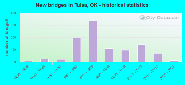
- New bridges - historical statistics
- 11910-1919
- 11920-1929
- 91930-1939
- 261940-1949
- 221950-1959
- 1971960-1969
- 3341970-1979
- 1101980-1989
- 961990-1999
- 1422000-2009
- 692010-2019
- 112020-2022
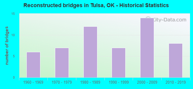
- Reconstructed bridges - Historical Statistics
- 61960-1969
- 71970-1979
- 121980-1989
- 71990-1999
- 142000-2009
- 82010-2019
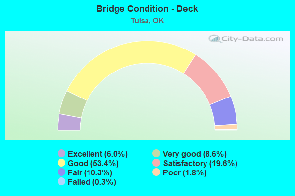
- Bridge Condition - Deck
- 6.0%Excellent
- 8.6%Very good
- 53.4%Good
- 19.6%Satisfactory
- 10.3%Fair
- 1.8%Poor
- 0.3%Failed
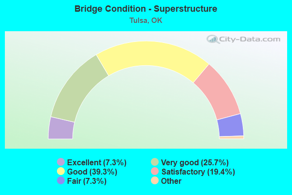
- Bridge Condition - Superstructure
- 7.3%Excellent
- 25.7%Very good
- 39.3%Good
- 19.4%Satisfactory
- 7.3%Fair
- 1.0%Poor
- 0.3%Critical
- 0.3%Failed
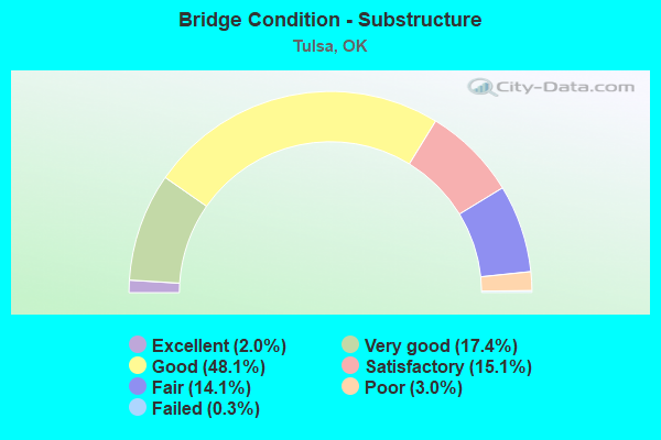
- Bridge Condition - Substructure
- 2.0%Excellent
- 17.4%Very good
- 48.1%Good
- 15.1%Satisfactory
- 14.1%Fair
- 3.0%Poor
- 0.3%Failed
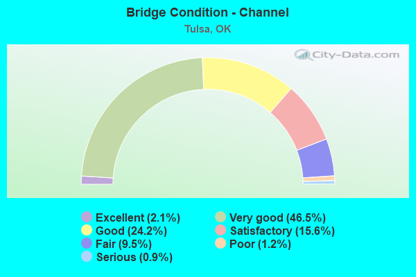
- Bridge Condition - Channel
- 2.1%Excellent
- 46.5%Very good
- 24.2%Good
- 15.6%Satisfactory
- 9.5%Fair
- 1.2%Poor
- 0.9%Serious
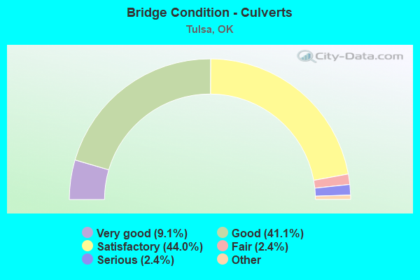
- Bridge Condition - Culverts
- 9.1%Excellent
- 41.1%Very good
- 44.0%Good
- 2.4%Satisfactory
- 2.4%Fair
- 1.0%Poor
- 2.4%Serious
Find on map >> Show street view
Structure Number: 18094, Location: 4.8 MI N JCT I-44 (Lat: 36.205833, Lng: -95.851389), Route carried "under" structure: US 169, Year Built: 1971, Structure Length: 0. m, Average Daily Traffic: 60,600 (year 2020), Truck Traffic: 8%, Features Intersected: U.S. 169 UNDER, Facility Carried by Structure: E. 36TH N. ST.
Minimum Vertical Clearance: 4.93m (16.17ft), Kilometerpoint: 7.498, Lanes on structure: 6, Lanes under structure: 8, Material/Design: Prestressed concrete, Design/Construction: Stringer/Multi-beam, Length of Maximum Span: 30.5m (100.1ft)
Find on map >> Show street view
Structure Number: 18097, Location: 1.41 MI N SH 51 (Lat: 36.157636, Lng: -95.980689), Route carried "under" structure: Interstate 444, Year Built: 1971, Structure Length: 0. m, Average Daily Traffic: 46,000 (year 2020), Truck Traffic: 12%, Features Intersected: I-444 UNDER, Facility Carried by Structure: 2ND ST.
Minimum Vertical Clearance: 4.77m (15.65ft), Kilometerpoint: 1.706, Lanes on structure: 3, Lanes under structure: 2, Material/Design: Steel, Design/Construction: Stringer/Multi-beam, Length of Maximum Span: 28.7m (94.2ft)
Find on map >> Show street view
Structure Number: 18097, Location: 1.41 MI N SH 51 (Lat: 36.157636, Lng: -95.980689), Route carried "under" structure: Ramp Interstate 244, Year Built: 1971, Structure Length: 0. m, Average Daily Traffic: 10,000 (year 2020), Truck Traffic: 12%, Features Intersected: I-444 UNDER, Facility Carried by Structure: 2ND ST.
Minimum Vertical Clearance: 5.03m (16.50ft), Kilometerpoint: 1.706, Lanes on structure: 3, Lanes under structure: 1, Material/Design: Steel, Design/Construction: Stringer/Multi-beam, Length of Maximum Span: 28.7m (94.2ft)
Find on map >> Show street view
Structure Number: 18097, Location: 1.41 MI N SH 51 (Lat: 36.157636, Lng: -95.980689), Route carried "under" structure: Interstate 444, Year Built: 1971, Structure Length: 0. m, Average Daily Traffic: 46,000 (year 2020), Truck Traffic: 12%, Features Intersected: I-444 UNDER, Facility Carried by Structure: 2ND ST.
Minimum Vertical Clearance: 4.62m (15.16ft), Kilometerpoint: 1.706, Lanes on structure: 3, Lanes under structure: 2, Material/Design: Steel, Design/Construction: Stringer/Multi-beam, Length of Maximum Span: 28.7m (94.2ft)
Find on map >> Show street view
Structure Number: 18097, Location: 1.41 MI N SH 51 (Lat: 36.157636, Lng: -95.980689), Route carried "under" structure: Ramp Interstate 444, Year Built: 1971, Structure Length: 0. m, Average Daily Traffic: 10,000 (year 2020), Truck Traffic: 12%, Features Intersected: I-444 UNDER, Facility Carried by Structure: 2ND ST.
Minimum Vertical Clearance: 5.23m (17.16ft), Kilometerpoint: 1.706, Lanes on structure: 3, Lanes under structure: 1, Material/Design: Steel, Design/Construction: Stringer/Multi-beam, Length of Maximum Span: 28.7m (94.2ft)
Find on map >> Show street view
Structure Number: 18102, Location: 6.5 MI N I-44 (Lat: 36.160803, Lng: -95.986919), Route carried "under" structure: City street , Year Built: 1971, Structure Length: 0. m, Average Daily Traffic: 1,000 (year 2020), Truck Traffic: 5%, Features Intersected: GREENWOOD AVE. UNDER, Facility Carried by Structure: I-244
Minimum Vertical Clearance: 6.45m (21.16ft), Kilometerpoint: 10.491, Lanes on structure: 3, Lanes under structure: 2, Material/Design: Steel, Design/Construction: Stringer/Multi-beam, Length of Maximum Span: 35.1m (115.2ft)
Find on map >> Show street view
Structure Number: 1811, Location: 6.9 MI N I-44 (Lat: 36.158511, Lng: -95.980219), Route carried "under" structure: Ramp City street , Year Built: 1971, Structure Length: 0. m, Average Daily Traffic: 1,000 (year 2020), Truck Traffic: 7%, Features Intersected: I-444 NB UNDER, Facility Carried by Structure: I-244 E-S RAMP
Minimum Vertical Clearance: 5.49m (18.01ft), Kilometerpoint: 2.334, Lanes on structure: 1, Lanes under structure: 1, Material/Design: Steel, Design/Construction: Stringer/Multi-beam, Length of Maximum Span: 25.6m (84.0ft)
Find on map >> Show street view
Structure Number: 1811, Location: 6.9 MI N I-44 (Lat: 36.158511, Lng: -95.980219), Route carried "under" structure: Interstate 444, Year Built: 1971, Structure Length: 0. m, Average Daily Traffic: 46,000 (year 2020), Truck Traffic: 12%, Features Intersected: I-444 NB UNDER, Facility Carried by Structure: I-244 E-S RAMP
Minimum Vertical Clearance: 5.00m (16.40ft), Kilometerpoint: 2.334, Lanes on structure: 1, Lanes under structure: 2, Material/Design: Steel, Design/Construction: Stringer/Multi-beam, Length of Maximum Span: 25.6m (84.0ft)
Find on map >> Show street view
Structure Number: 18111, Location: 0.1 MI N JCT I-244 (Lat: 36.162311, Lng: -95.981183), Route carried "under" structure: US 75, Year Built: 1971, Structure Length: 0. m, Average Daily Traffic: 5,000 (year 2020), Truck Traffic: 8%, Features Intersected: U.S. 75 UNDER, Facility Carried by Structure: ARCHER ST.
Minimum Vertical Clearance: 5.33m (17.49ft), Kilometerpoint: 0.000, Lanes on structure: 2, Lanes under structure: 1, Material/Design: Steel continuous, Design/Construction: Stringer/Multi-beam, Length of Maximum Span: 39.3m (128.9ft)
Find on map >> Show street view
Structure Number: 18111, Location: 0.1 MI N JCT I-244 (Lat: 36.162311, Lng: -95.981183), Route carried "under" structure: State highway 244, Year Built: 1971, Structure Length: 0. m, Average Daily Traffic: 5,000 (year 2020), Truck Traffic: 12%, Features Intersected: U.S. 75 UNDER, Facility Carried by Structure: ARCHER ST.
Minimum Vertical Clearance: 4.85m (15.91ft), Kilometerpoint: 0.000, Lanes on structure: 2, Lanes under structure: 1, Material/Design: Steel continuous, Design/Construction: Stringer/Multi-beam, Length of Maximum Span: 39.3m (128.9ft)
Find on map >> Show street view
Structure Number: 18111, Location: 0.1 MI N JCT I-244 (Lat: 36.162311, Lng: -95.981183), Route carried "under" structure: US 75, Year Built: 1971, Structure Length: 0. m, Average Daily Traffic: 5,000 (year 2020), Truck Traffic: 8%, Features Intersected: U.S. 75 UNDER, Facility Carried by Structure: ARCHER ST.
Minimum Vertical Clearance: 4.65m (15.26ft), Kilometerpoint: 0.000, Lanes on structure: 2, Lanes under structure: 1, Material/Design: Steel continuous, Design/Construction: Stringer/Multi-beam, Length of Maximum Span: 39.3m (128.9ft)
Find on map >> Show street view
Structure Number: 18111, Location: 0.1 MI N JCT I-244 (Lat: 36.162311, Lng: -95.981183), Route carried "under" structure: US 75, Year Built: 1971, Structure Length: 0. m, Average Daily Traffic: 39,600 (year 2020), Truck Traffic: 8%, Features Intersected: U.S. 75 UNDER, Facility Carried by Structure: ARCHER ST.
Minimum Vertical Clearance: 5.11m (16.77ft), Kilometerpoint: 0.290, Lanes on structure: 2, Lanes under structure: 3, Material/Design: Steel continuous, Design/Construction: Stringer/Multi-beam, Length of Maximum Span: 39.3m (128.9ft)
Find on map >> Show street view
Structure Number: 18111, Location: 0.1 MI N JCT I-244 (Lat: 36.162311, Lng: -95.981183), Route carried "under" structure: US 75, Year Built: 1971, Structure Length: 0. m, Average Daily Traffic: 39,600 (year 2020), Truck Traffic: 8%, Features Intersected: U.S. 75 UNDER, Facility Carried by Structure: ARCHER ST.
Minimum Vertical Clearance: 5.21m (17.09ft), Kilometerpoint: 0.290, Lanes on structure: 2, Lanes under structure: 3, Material/Design: Steel continuous, Design/Construction: Stringer/Multi-beam, Length of Maximum Span: 39.3m (128.9ft)
Find on map >> Show street view
Structure Number: 18113, Location: I-244 & 75 JCT. (Lat: 36.160519, Lng: -95.981203), Route carried "under" structure: US 75, Year Built: 1971, Structure Length: 0. m, Average Daily Traffic: 20,350 (year 2020), Truck Traffic: 8%, Features Intersected: U.S. 75 & RAMP UNDER, Facility Carried by Structure: I-244 RAMP W-N
Minimum Vertical Clearance: 8.58m (28.15ft), Kilometerpoint: 0.097, Lanes on structure: 1, Lanes under structure: 2, Material/Design: Steel continuous, Design/Construction: Stringer/Multi-beam, Length of Maximum Span: 33.2m (108.9ft)
Find on map >> Show street view
Structure Number: 18113, Location: I-244 & 75 JCT. (Lat: 36.160519, Lng: -95.981203), Route carried "under" structure: Ramp US , Year Built: 1971, Structure Length: 0. m, Average Daily Traffic: 1,000 (year 2020), Truck Traffic: 8%, Features Intersected: U.S. 75 & RAMP UNDER, Facility Carried by Structure: I-244 RAMP W-N
Minimum Vertical Clearance: 4.62m (15.16ft), Kilometerpoint: 0.097, Lanes on structure: 1, Lanes under structure: 1, Material/Design: Steel continuous, Design/Construction: Stringer/Multi-beam, Length of Maximum Span: 33.2m (108.9ft)
Find on map >> Show street view
Structure Number: 18113, Location: I-244 & 75 JCT. (Lat: 36.160519, Lng: -95.981203), Route carried "under" structure: Ramp US , Year Built: 1971, Structure Length: 0. m, Average Daily Traffic: 1,000 (year 2020), Truck Traffic: 8%, Features Intersected: U.S. 75 & RAMP UNDER, Facility Carried by Structure: I-244 RAMP W-N
Minimum Vertical Clearance: 9.02m (29.59ft), Kilometerpoint: 0.097, Lanes on structure: 1, Lanes under structure: 2, Material/Design: Steel continuous, Design/Construction: Stringer/Multi-beam, Length of Maximum Span: 33.2m (108.9ft)
Find on map >> Show street view
Structure Number: 18118, Location: 5.7 MI N I-44 (Lat: 36.160261, Lng: -96.001208), Route carried "under" structure: Ramp Interstate 244, Year Built: 1971, Structure Length: 0. m, Average Daily Traffic: 29,500 (year 2020), Truck Traffic: 12%, Features Intersected: I-244 WB E-S UNDER, Facility Carried by Structure: TISDALE EXPY N-E
Minimum Vertical Clearance: 5.15m (16.90ft), Kilometerpoint: 24.618, Lanes on structure: 1, Lanes under structure: 2, Material/Design: Concrete continuous, Design/Construction: Slab, Length of Maximum Span: 17.7m (58.1ft)
Find on map >> Show street view
Structure Number: 18118, Location: 5.7 MI N I-44 (Lat: 36.160261, Lng: -96.001208), Route carried "under" structure: Interstate 244, Year Built: 1971, Structure Length: 0. m, Average Daily Traffic: 29,500 (year 2020), Truck Traffic: 12%, Features Intersected: I-244 WB E-S UNDER, Facility Carried by Structure: TISDALE EXPY N-E
Minimum Vertical Clearance: 4.90m (16.08ft), Kilometerpoint: 9.220, Lanes on structure: 1, Lanes under structure: 2, Material/Design: Concrete continuous, Design/Construction: Slab, Length of Maximum Span: 17.7m (58.1ft)
Find on map >> Show street view
Structure Number: 18127, Location: 5.7 MI N I-44 (Lat: 36.159794, Lng: -95.999883), Route carried "under" structure: Interstate 244, Year Built: 1971, Structure Length: 0. m, Average Daily Traffic: 62,700 (year 2020), Truck Traffic: 12%, Features Intersected: I-244 UNDER, Facility Carried by Structure: TISDALE EXPY
Minimum Vertical Clearance: 4.82m (15.81ft), Kilometerpoint: 9.284, Lanes on structure: 2, Lanes under structure: 2, Material/Design: Steel continuous, Design/Construction: Girder and Floorbeam System, Length of Maximum Span: 27.4m (89.9ft)
Find on map >> Show street view
Structure Number: 18127, Location: 5.7 MI N I-44 (Lat: 36.159794, Lng: -95.999883), Route carried "under" structure: US 412, Year Built: 1971, Structure Length: 0. m, Average Daily Traffic: 55,000 (year 2020), Truck Traffic: 7%, Features Intersected: I-244 UNDER, Facility Carried by Structure: TISDALE EXPY
Minimum Vertical Clearance: 4.75m (15.58ft), Kilometerpoint: 24.683, Lanes on structure: 2, Lanes under structure: 2, Material/Design: Steel continuous, Design/Construction: Girder and Floorbeam System, Length of Maximum Span: 27.4m (89.9ft)
Find on map >> Show street view
Structure Number: 18127, Location: 5.7 MI N I-44 (Lat: 36.159794, Lng: -95.999883), Route carried "under" structure: Interstate 244, Year Built: 1971, Structure Length: 0. m, Average Daily Traffic: 55,000 (year 2020), Truck Traffic: 12%, Features Intersected: I-244 UNDER, Facility Carried by Structure: TISDALE EXPY
Minimum Vertical Clearance: 5.18m (16.99ft), Kilometerpoint: 24.683, Lanes on structure: 2, Lanes under structure: 2, Material/Design: Steel continuous, Design/Construction: Girder and Floorbeam System, Length of Maximum Span: 27.4m (89.9ft)
Find on map >> Show street view
Structure Number: 18127, Location: 5.7 MI N I-44 (Lat: 36.159794, Lng: -95.999883), Route carried "under" structure: Ramp US , Year Built: 1971, Structure Length: 0. m, Average Daily Traffic: 60,000 (year 2020), Truck Traffic: 7%, Features Intersected: I-244 UNDER, Facility Carried by Structure: TISDALE EXPY
Minimum Vertical Clearance: 4.62m (15.16ft), Kilometerpoint: 0.161, Lanes on structure: 2, Lanes under structure: 1, Material/Design: Steel continuous, Design/Construction: Girder and Floorbeam System, Length of Maximum Span: 27.4m (89.9ft)
Find on map >> Show street view
Structure Number: 18128, Location: 6.9 MI N I-44 (Lat: 36.158642, Lng: -95.980764), Route carried "under" structure: City street , Year Built: 1971, Structure Length: 0. m, Average Daily Traffic: 5,000 (year 2020), Truck Traffic: 5%, Features Intersected: I-444 UNDER, Facility Carried by Structure: I-244 RMP TO E.1ST
Minimum Vertical Clearance: 4.47m (14.67ft), Kilometerpoint: 1.722, Lanes on structure: 2, Lanes under structure: 1, Material/Design: Steel, Design/Construction: Stringer/Multi-beam, Length of Maximum Span: 25.0m (82.0ft)
Find on map >> Show street view
Structure Number: 18128, Location: 6.9 MI N I-44 (Lat: 36.158642, Lng: -95.980764), Route carried "under" structure: Interstate 444, Year Built: 1971, Structure Length: 0. m, Average Daily Traffic: 46,000 (year 2020), Truck Traffic: 12%, Features Intersected: I-444 UNDER, Facility Carried by Structure: I-244 RMP TO E.1ST
Minimum Vertical Clearance: 4.77m (15.65ft), Kilometerpoint: 1.915, Lanes on structure: 2, Lanes under structure: 5, Material/Design: Steel, Design/Construction: Stringer/Multi-beam, Length of Maximum Span: 25.0m (82.0ft)
Find on map >> Show street view
Structure Number: 18129, Location: 0.5 MI E JCT I-244 (Lat: 36.145169, Lng: -95.995083), Route carried "under" structure: Ramp City street , Year Built: 1971, Structure Length: 0. m, Average Daily Traffic: 1,000 (year 2020), Truck Traffic: 5%, Features Intersected: U.S. 64 / US 75 / SH 51, Facility Carried by Structure: 12TH ST.
Minimum Vertical Clearance: 4.98m (16.34ft), Kilometerpoint: 0.000, Lanes on structure: 4, Lanes under structure: 1, Material/Design: Steel continuous, Design/Construction: Girder and Floorbeam System, Length of Maximum Span: 40.8m (133.9ft)
Find on map >> Show street view
Structure Number: 18129, Location: 0.5 MI E JCT I-244 (Lat: 36.145169, Lng: -95.995083), Route carried "under" structure: Interstate 444, Year Built: 1971, Structure Length: 0. m, Average Daily Traffic: 47,200 (year 2020), Truck Traffic: 12%, Features Intersected: U.S. 64 / US 75 / SH 51, Facility Carried by Structure: 12TH ST.
Minimum Vertical Clearance: 5.05m (16.57ft), Kilometerpoint: 1.014, Lanes on structure: 4, Lanes under structure: 6, Material/Design: Steel continuous, Design/Construction: Girder and Floorbeam System, Length of Maximum Span: 40.8m (133.9ft)
Find on map >> Show street view
Structure Number: 18132, Location: US75 & I-444 JCT (Lat: 36.159064, Lng: -95.979128), Route carried "under" structure: Ramp Interstate 244, Year Built: 1971, Structure Length: 0. m, Average Daily Traffic: 1,000 (year 2020), Truck Traffic: 12%, Features Intersected: 2ND/ 1 ST. & US75 UNDER, Facility Carried by Structure: U.S. 75 RAMP N - E
Minimum Vertical Clearance: 6.14m (20.14ft), Kilometerpoint: 11.216, Lanes on structure: 1, Lanes under structure: 2, Material/Design: Steel continuous, Design/Construction: Girder and Floorbeam System, Length of Maximum Span: 32.6m (107.0ft)
Find on map >> Show street view
Structure Number: 18132, Location: US75 & I-444 JCT (Lat: 36.159064, Lng: -95.979128), Route carried "under" structure: City street , Year Built: 1971, Structure Length: 0. m, Average Daily Traffic: 5,000 (year 2020), Truck Traffic: 5%, Features Intersected: 2ND/ 1 ST. & US75 UNDER, Facility Carried by Structure: U.S. 75 RAMP N - E
Minimum Vertical Clearance: 9.32m (30.58ft), Kilometerpoint: 0.000, Lanes on structure: 1, Lanes under structure: 1, Material/Design: Steel continuous, Design/Construction: Girder and Floorbeam System, Length of Maximum Span: 32.6m (107.0ft)
Find on map >> Show street view
Structure Number: 18132, Location: US75 & I-444 JCT (Lat: 36.159064, Lng: -95.979128), Route carried "under" structure: Ramp Interstate 244, Year Built: 1971, Structure Length: 0. m, Average Daily Traffic: 1,000 (year 2020), Truck Traffic: 12%, Features Intersected: 2ND/ 1 ST. & US75 UNDER, Facility Carried by Structure: U.S. 75 RAMP N - E
Minimum Vertical Clearance: 4.57m (14.99ft), Kilometerpoint: 0.000, Lanes on structure: 1, Lanes under structure: 1, Material/Design: Steel continuous, Design/Construction: Girder and Floorbeam System, Length of Maximum Span: 32.6m (107.0ft)
Find on map >> Show street view
Structure Number: 18132, Location: US75 & I-444 JCT (Lat: 36.159064, Lng: -95.979128), Route carried "under" structure: Interstate 444, Year Built: 1971, Structure Length: 0. m, Average Daily Traffic: 39,600 (year 2020), Truck Traffic: 12%, Features Intersected: 2ND/ 1 ST. & US75 UNDER, Facility Carried by Structure: U.S. 75 RAMP N - E
Minimum Vertical Clearance: 5.89m (19.32ft), Kilometerpoint: 0.000, Lanes on structure: 1, Lanes under structure: 2, Material/Design: Steel continuous, Design/Construction: Girder and Floorbeam System, Length of Maximum Span: 32.6m (107.0ft)
Find on map >> Show street view
Structure Number: 18136, Location: 5.6 MI N I-44 (Lat: 36.158206, Lng: -96.002106), Route carried "under" structure: Interstate 244, Year Built: 1971, Structure Length: 0. m, Average Daily Traffic: 10,000 (year 2020), Truck Traffic: 12%, Features Intersected: U.S. 64 UNDER
Minimum Vertical Clearance: 5.28m (17.32ft), Kilometerpoint: 24.232, Lanes on structure: 2, Lanes under structure: 2, Material/Design: Steel, Design/Construction: Girder and Floorbeam System, Length of Maximum Span: 32.0m (105.0ft)
Find on map >> Show street view
Structure Number: 18136, Location: 5.6 MI N I-44 (Lat: 36.158206, Lng: -96.002106), Route carried "under" structure: Interstate 244, Year Built: 1971, Structure Length: 0. m, Average Daily Traffic: 10,000 (year 2020), Truck Traffic: 12%, Features Intersected: U.S. 64 UNDER
Minimum Vertical Clearance: 7.71m (25.30ft), Kilometerpoint: 24.232, Lanes on structure: 2, Lanes under structure: 1, Material/Design: Steel, Design/Construction: Girder and Floorbeam System, Length of Maximum Span: 32.0m (105.0ft)
Find on map >> Show street view
Structure Number: 18136, Location: 5.6 MI N I-44 (Lat: 36.158206, Lng: -96.002106), Route carried "under" structure: US 412, Year Built: 1971, Structure Length: 0. m, Average Daily Traffic: 55,000 (year 2020), Truck Traffic: 8%, Features Intersected: U.S. 64 UNDER, Facility Carried by Structure: I-244
Minimum Vertical Clearance: 4.75m (15.58ft), Kilometerpoint: 24.232, Lanes on structure: 2, Lanes under structure: 2, Material/Design: Steel, Design/Construction: Girder and Floorbeam System, Length of Maximum Span: 32.0m (105.0ft)
Find on map >> Show street view
Structure Number: 18145, Location: 6.7 MI N I-44 (Lat: 36.159694, Lng: -95.982836), Route carried "under" structure: Ramp Interstate 244, Year Built: 1971, Structure Length: 0. m, Average Daily Traffic: 5,000 (year 2020), Truck Traffic: 12%, Features Intersected: I-444 / BNSF R.R. UNDER
Minimum Vertical Clearance: 14.37m (47.15ft), Kilometerpoint: 11.038, Lanes on structure: 2, Lanes under structure: 1, Material/Design: Steel continuous, Design/Construction: Stringer/Multi-beam, Length of Maximum Span: 25.6m (84.0ft)
Find on map >> Show street view
Structure Number: 18145, Location: 6.7 MI N I-44 (Lat: 36.159694, Lng: -95.982836), Route carried "under" structure: Ramp Interstate 244, Year Built: 1971, Structure Length: 0. m, Average Daily Traffic: 20,000 (year 2020), Truck Traffic: 12%, Features Intersected: I-444 / BNSF R.R. UNDER
Minimum Vertical Clearance: 5.38m (17.65ft), Kilometerpoint: 11.117, Lanes on structure: 2, Lanes under structure: 1, Material/Design: Steel continuous, Design/Construction: Stringer/Multi-beam, Length of Maximum Span: 25.6m (84.0ft)
Find on map >> Show street view
Structure Number: 18145, Location: 6.7 MI N I-44 (Lat: 36.159694, Lng: -95.982836), Route carried "under" structure: Ramp Interstate 244, Year Built: 1971, Structure Length: 0. m, Average Daily Traffic: 7,200 (year 2020), Truck Traffic: 12%, Features Intersected: I-444 / BNSF R.R. UNDER
Minimum Vertical Clearance: 6.37m (20.90ft), Kilometerpoint: 11.199, Lanes on structure: 2, Lanes under structure: 2, Material/Design: Steel continuous, Design/Construction: Stringer/Multi-beam, Length of Maximum Span: 25.6m (84.0ft)
Find on map >> Show street view
Structure Number: 18145, Location: 6.7 MI N I-44 (Lat: 36.159694, Lng: -95.982836), Route carried "under" structure: Interstate 444, Year Built: 1971, Structure Length: 0. m, Average Daily Traffic: 46,000 (year 2020), Truck Traffic: 12%, Features Intersected: I-444 / BNSF R.R. UNDER, Facility Carried by Structure: I-244 EB
Minimum Vertical Clearance: 12.55m (41.17ft), Kilometerpoint: 2.253, Lanes on structure: 2, Lanes under structure: 2, Material/Design: Steel continuous, Design/Construction: Stringer/Multi-beam, Length of Maximum Span: 25.6m (84.0ft)
Find on map >> Show street view
Structure Number: 18145, Location: 6.7 MI N I-44 (Lat: 36.159694, Lng: -95.982836), Route carried "under" structure: Interstate 444, Year Built: 1971, Structure Length: 0. m, Average Daily Traffic: 20,350 (year 2020), Truck Traffic: 12%, Features Intersected: I-444 / BNSF R.R. UNDER, Facility Carried by Structure: I-244 EB
Minimum Vertical Clearance: 13.82m (45.34ft), Kilometerpoint: 2.253, Lanes on structure: 2, Lanes under structure: 2, Material/Design: Steel continuous, Design/Construction: Stringer/Multi-beam, Length of Maximum Span: 25.6m (84.0ft)
Find on map >> Show street view
Structure Number: 18145, Location: 6.7 MI N I-44 (Lat: 36.159694, Lng: -95.982836), Route carried "under" structure: Ramp City street , Year Built: 1971, Structure Length: 0. m, Average Daily Traffic: 5,000 (year 2020), Truck Traffic: 5%, Features Intersected: I-444 / BNSF R.R. UNDER, Facility Carried by Structure: I-244 EB
Minimum Vertical Clearance: 30+ m (98+ ft), Kilometerpoint: 1.722, Lanes on structure: 2, Lanes under structure: 1, Material/Design: Steel continuous, Design/Construction: Stringer/Multi-beam, Length of Maximum Span: 25.6m (84.0ft)
Find on map >> Show street view
Structure Number: 18145, Location: 6.7 MI N I-44 (Lat: 36.159694, Lng: -95.982836), Route carried "under" structure: Ramp US 75, Year Built: 1971, Structure Length: 0. m, Average Daily Traffic: 5,000 (year 2020), Truck Traffic: 8%, Features Intersected: I-444 / BNSF R.R. UNDER, Facility Carried by Structure: I-244 EB
Minimum Vertical Clearance: 7.34m (24.08ft), Kilometerpoint: 0.000, Lanes on structure: 2, Lanes under structure: 1, Material/Design: Steel continuous, Design/Construction: Stringer/Multi-beam, Length of Maximum Span: 25.6m (84.0ft)
Find on map >> Show street view
Structure Number: 18146, Location: 6.6 MI N I-44 (Lat: 36.160742, Lng: -95.984808), Route carried "under" structure: City street , Year Built: 1971, Structure Length: 0. m, Average Daily Traffic: 5,000 (year 2020), Truck Traffic: 5%, Features Intersected: I-444 & SK&O R.R. UNDER, Facility Carried by Structure: I-244 WB
Minimum Vertical Clearance: 4.60m (15.09ft), Kilometerpoint: 10.684, Lanes on structure: 2, Lanes under structure: 2, Material/Design: Steel continuous, Design/Construction: Girder and Floorbeam System, Length of Maximum Span: 39.9m (130.9ft)
Find on map >> Show street view
Structure Number: 18146, Location: 6.6 MI N I-44 (Lat: 36.160742, Lng: -95.984808), Route carried "under" structure: Ramp Interstate 244, Year Built: 1971, Structure Length: 0. m, Average Daily Traffic: 10,000 (year 2020), Truck Traffic: 12%, Features Intersected: I-444 & SK&O R.R. UNDER
Minimum Vertical Clearance: 4.88m (16.01ft), Kilometerpoint: 10.747, Lanes on structure: 2, Lanes under structure: 1, Material/Design: Steel continuous, Design/Construction: Girder and Floorbeam System, Length of Maximum Span: 39.9m (130.9ft)
Find on map >> Show street view
Structure Number: 18146, Location: 6.6 MI N I-44 (Lat: 36.160742, Lng: -95.984808), Route carried "under" structure: Interstate 244, Year Built: 1971, Structure Length: 0. m, Average Daily Traffic: 10,000 (year 2020), Truck Traffic: 12%, Features Intersected: I-444 & SK&O R.R. UNDER
Minimum Vertical Clearance: 4.72m (15.49ft), Kilometerpoint: 10.779, Lanes on structure: 2, Lanes under structure: 1, Material/Design: Steel continuous, Design/Construction: Girder and Floorbeam System, Length of Maximum Span: 39.9m (130.9ft)
Find on map >> Show street view
Structure Number: 18146, Location: 6.6 MI N I-44 (Lat: 36.160742, Lng: -95.984808), Route carried "under" structure: Interstate 244, Year Built: 1971, Structure Length: 0. m, Average Daily Traffic: 10,000 (year 2020), Truck Traffic: 12%, Features Intersected: I-444 & SK&O R.R. UNDER
Minimum Vertical Clearance: 12.55m (41.17ft), Kilometerpoint: 10.910, Lanes on structure: 2, Lanes under structure: 1, Material/Design: Steel continuous, Design/Construction: Girder and Floorbeam System, Length of Maximum Span: 39.9m (130.9ft)
Find on map >> Show street view
Structure Number: 18146, Location: 6.6 MI N I-44 (Lat: 36.160742, Lng: -95.984808), Route carried "under" structure: Interstate 444, Year Built: 1971, Structure Length: 0. m, Average Daily Traffic: 20,350 (year 2020), Truck Traffic: 12%, Features Intersected: I-444 & SK&O R.R. UNDER, Facility Carried by Structure: I-244 WB
Minimum Vertical Clearance: 14.68m (48.16ft), Kilometerpoint: 2.253, Lanes on structure: 2, Lanes under structure: 2, Material/Design: Steel continuous, Design/Construction: Girder and Floorbeam System, Length of Maximum Span: 39.9m (130.9ft)
Find on map >> Show street view
Structure Number: 18146, Location: 6.6 MI N I-44 (Lat: 36.160742, Lng: -95.984808), Route carried "under" structure: Ramp US 75, Year Built: 1971, Structure Length: 0. m, Average Daily Traffic: 1,000 (year 2020), Truck Traffic: 5%, Features Intersected: I-444 & SK&O R.R. UNDER, Facility Carried by Structure: I-244 WB
Minimum Vertical Clearance: 8.51m (27.92ft), Kilometerpoint: 0.000, Lanes on structure: 2, Lanes under structure: 1, Material/Design: Steel continuous, Design/Construction: Girder and Floorbeam System, Length of Maximum Span: 39.9m (130.9ft)
Find on map >> Show street view
Structure Number: 18146, Location: 6.6 MI N I-44 (Lat: 36.160742, Lng: -95.984808), Route carried "under" structure: Ramp US 75, Year Built: 1971, Structure Length: 0. m, Average Daily Traffic: 5,000 (year 2020), Truck Traffic: 8%, Features Intersected: I-444 & SK&O R.R. UNDER, Facility Carried by Structure: I-244 WB
Minimum Vertical Clearance: 5.97m (19.59ft), Kilometerpoint: 0.000, Lanes on structure: 2, Lanes under structure: 1, Material/Design: Steel continuous, Design/Construction: Girder and Floorbeam System, Length of Maximum Span: 39.9m (130.9ft)
Find on map >> Show street view
Structure Number: 18146, Location: 6.6 MI N I-44 (Lat: 36.160742, Lng: -95.984808), Route carried "under" structure: Interstate 444, Year Built: 1971, Structure Length: 0. m, Average Daily Traffic: 46,000 (year 2020), Truck Traffic: 12%, Features Intersected: I-444 & SK&O R.R. UNDER, Facility Carried by Structure: I-244 WB
Minimum Vertical Clearance: 12.34m (40.49ft), Kilometerpoint: 2.253, Lanes on structure: 2, Lanes under structure: 2, Material/Design: Steel continuous, Design/Construction: Girder and Floorbeam System, Length of Maximum Span: 39.9m (130.9ft)
Find on map >> Show street view
Structure Number: 18146, Location: 6.6 MI N I-44 (Lat: 36.160742, Lng: -95.984808), Route carried "under" structure: City street , Year Built: 1971, Structure Length: 0. m, Average Daily Traffic: 900 (year 2020), Truck Traffic: 5%, Features Intersected: I-444 & SK&O R.R. UNDER, Facility Carried by Structure: I-244 WB
Minimum Vertical Clearance: 7.16m (23.49ft), Kilometerpoint: 11.199, Lanes on structure: 2, Lanes under structure: 1, Material/Design: Steel continuous, Design/Construction: Girder and Floorbeam System, Length of Maximum Span: 39.9m (130.9ft)
Find on map >> Show street view
Structure Number: 18146, Location: 6.6 MI N I-44 (Lat: 36.160742, Lng: -95.984808), Route carried "under" structure: City street , Year Built: 1971, Structure Length: 0. m, Average Daily Traffic: 5,000 (year 2020), Truck Traffic: 5%, Features Intersected: I-444 & SK&O R.R. UNDER, Facility Carried by Structure: I-244 WB
Minimum Vertical Clearance: 12.52m (41.08ft), Kilometerpoint: 1.722, Lanes on structure: 2, Lanes under structure: 1, Material/Design: Steel continuous, Design/Construction: Girder and Floorbeam System, Length of Maximum Span: 39.9m (130.9ft)
Find on map >> Show street view
Structure Number: 18146, Location: 6.6 MI N I-44 (Lat: 36.160742, Lng: -95.984808), Route carried "under" structure: Ramp Interstate 244, Year Built: 1971, Structure Length: 0. m, Average Daily Traffic: 10,000 (year 2020), Truck Traffic: 12%, Features Intersected: I-444 & SK&O R.R. UNDER
Minimum Vertical Clearance: 4.82m (15.81ft), Kilometerpoint: 11.038, Lanes on structure: 2, Lanes under structure: 1, Material/Design: Steel continuous, Design/Construction: Girder and Floorbeam System, Length of Maximum Span: 39.9m (130.9ft)
Find on map >> Show street view
Structure Number: 18146, Location: 6.6 MI N I-44 (Lat: 36.160742, Lng: -95.984808), Route carried "under" structure: City street , Year Built: 1971, Structure Length: 0. m, Average Daily Traffic: 1,000 (year 2020), Truck Traffic: 5%, Features Intersected: I-444 & SK&O R.R. UNDER, Facility Carried by Structure: I-244 WB
Minimum Vertical Clearance: 7.16m (23.49ft), Kilometerpoint: 11.087, Lanes on structure: 2, Lanes under structure: 1, Material/Design: Steel continuous, Design/Construction: Girder and Floorbeam System, Length of Maximum Span: 39.9m (130.9ft)
Find on map >> Show street view
Structure Number: 18146, Location: 6.6 MI N I-44 (Lat: 36.160742, Lng: -95.984808), Route carried "under" structure: Ramp Interstate 244, Year Built: 1971, Structure Length: 0. m, Average Daily Traffic: 2,000 (year 2020), Truck Traffic: 12%, Features Intersected: I-444 & SK&O R.R. UNDER
Minimum Vertical Clearance: 5.64m (18.50ft), Kilometerpoint: 11.117, Lanes on structure: 2, Lanes under structure: 2, Material/Design: Steel continuous, Design/Construction: Girder and Floorbeam System, Length of Maximum Span: 39.9m (130.9ft)
Find on map >> Show street view
Structure Number: 18253, Location: 2.7 MI N I-44 (Lat: 36.118653, Lng: -96.008686), Route carried "under" structure: City street , Year Built: 1972, Structure Length: 0. m, Average Daily Traffic: 800 (year 2020), Truck Traffic: 5%, Features Intersected: 31ST ST. UNDER, Facility Carried by Structure: I-244
Minimum Vertical Clearance: 4.62m (15.16ft), Kilometerpoint: 4.488, Lanes on structure: 6, Lanes under structure: 2, Material/Design: Steel, Design/Construction: Stringer/Multi-beam, Length of Maximum Span: 24.4m (80.1ft)
Find on map >> Show street view
Structure Number: 18254, Location: 10.5 MI N JCT SH 67 (Lat: 36.096989, Lng: -96.006531), Route carried "under" structure: City street , Year Built: 1972, Structure Length: 0. m, Average Daily Traffic: 300 (year 2020), Truck Traffic: 5%, Features Intersected: 46TH ST. UNDER, Facility Carried by Structure: U.S. 75 NB
Minimum Vertical Clearance: 4.60m (15.09ft), Kilometerpoint: 16.943, Lanes on structure: 2, Lanes under structure: 2, Material/Design: Steel, Design/Construction: Stringer/Multi-beam, Length of Maximum Span: 23.8m (78.1ft)
Find on map >> Show street view
Structure Number: 18255, Location: 10.5 MI N JCT SH 67 (Lat: 36.096992, Lng: -96.006897), Route carried "under" structure: City street , Year Built: 1972, Structure Length: 0. m, Average Daily Traffic: 300 (year 2020), Truck Traffic: 5%, Features Intersected: 46TH ST. UNDER, Facility Carried by Structure: U.S. 75 SB
Minimum Vertical Clearance: 4.34m (14.24ft), Kilometerpoint: 16.943, Lanes on structure: 2, Lanes under structure: 2, Material/Design: Steel, Design/Construction: Stringer/Multi-beam, Length of Maximum Span: 23.8m (78.1ft)
Find on map >> Show street view
Structure Number: 18266, Location: 5.9 MI N I-244 (Lat: 36.235014, Lng: -95.944897), Route carried "under" structure: City street , Year Built: 1972, Structure Length: 0. m, Average Daily Traffic: 800 (year 2020), Truck Traffic: 5%, Features Intersected: 56TH ST. UNDER, Facility Carried by Structure: U.S. 75 NB
Minimum Vertical Clearance: 4.98m (16.34ft), Kilometerpoint: 9.574, Lanes on structure: 3, Lanes under structure: 4, Material/Design: Prestressed concrete, Design/Construction: Stringer/Multi-beam, Length of Maximum Span: 30.5m (100.1ft)
Find on map >> Show street view
Structure Number: 18267, Location: 10.2 MI N JCT SH 67 (Lat: 36.092222, Lng: -96.006431), Route carried "under" structure: City street , Year Built: 1972, Structure Length: 0. m, Average Daily Traffic: 300 (year 2020), Truck Traffic: 5%, Features Intersected: 49TH ST. UNDER, Facility Carried by Structure: U.S. 75 NB
Minimum Vertical Clearance: 4.52m (14.83ft), Kilometerpoint: 16.412, Lanes on structure: 3, Lanes under structure: 2, Material/Design: Steel, Design/Construction: Stringer/Multi-beam, Length of Maximum Span: 30.5m (100.1ft)
Find on map >> Show street view
Structure Number: 18268, Location: 10.2 MI N JCT SH 67 (Lat: 36.092222, Lng: -96.006881), Route carried "under" structure: City street , Year Built: 1972, Structure Length: 0. m, Average Daily Traffic: 300 (year 2020), Truck Traffic: 5%, Features Intersected: 49TH ST. UNDER, Facility Carried by Structure: U.S. 75 SB
Minimum Vertical Clearance: 5.72m (18.77ft), Kilometerpoint: 16.412, Lanes on structure: 3, Lanes under structure: 2, Material/Design: Steel, Design/Construction: Stringer/Multi-beam, Length of Maximum Span: 30.5m (100.1ft)
Find on map >> Show street view
Structure Number: 18276, Location: 5.3 MI N I-44 (Lat: 36.154700, Lng: -96.001025), Route carried "under" structure: City street , Year Built: 1972, Structure Length: 0. m, Average Daily Traffic: 1,000 (year 2020), Truck Traffic: 5%, Features Intersected: ARCHER ST. UNDER, Facility Carried by Structure: I-244
Minimum Vertical Clearance: 5.05m (16.57ft), Kilometerpoint: 8.657, Lanes on structure: 3, Lanes under structure: 2, Material/Design: Concrete continuous, Design/Construction: Slab, Length of Maximum Span: 15.5m (50.9ft)
Find on map >> Show street view
Structure Number: 18277, Location: 5.3 MI N I-44 (Lat: 36.154700, Lng: -96.001617), Route carried "under" structure: City street , Year Built: 1972, Structure Length: 0. m, Average Daily Traffic: 1,000 (year 2020), Truck Traffic: 5%, Features Intersected: ARCHER ST. UNDER, Facility Carried by Structure: I-244
Minimum Vertical Clearance: 4.82m (15.81ft), Kilometerpoint: 8.657, Lanes on structure: 4, Lanes under structure: 2, Material/Design: Concrete continuous, Design/Construction: Slab, Length of Maximum Span: 15.5m (50.9ft)
Find on map >> Show street view
Structure Number: 18282, Location: 0.6 MI N SH 51 (Lat: 36.152564, Lng: -95.980083), Route carried "under" structure: City street , Year Built: 1972, Structure Length: 0. m, Average Daily Traffic: 500 (year 2020), Truck Traffic: 5%, Features Intersected: 6TH ST. UNDER, Facility Carried by Structure: U.S. 75
Minimum Vertical Clearance: 4.67m (15.32ft), Kilometerpoint: 1.062, Lanes on structure: 8, Lanes under structure: 4, Material/Design: Steel, Design/Construction: Stringer/Multi-beam, Length of Maximum Span: 20.9m (68.6ft)
Find on map >> Show street view
Structure Number: 18308, Location: 0.1 MI E JCT I-244 (Lat: 36.145303, Lng: -96.002453), Route carried "under" structure: City street , Year Built: 1972, Structure Length: 0. m, Average Daily Traffic: 300 (year 2020), Truck Traffic: 5%, Features Intersected: SOUTHWEST BLVD. UNDER, Facility Carried by Structure: I-444 RAMP
Minimum Vertical Clearance: 4.93m (16.17ft), Kilometerpoint: 0.209, Lanes on structure: 1, Lanes under structure: 4, Material/Design: Steel, Design/Construction: Stringer/Multi-beam, Length of Maximum Span: 27.4m (89.9ft)
Find on map >> Show street view
Structure Number: 18309, Location: 4.2 MI N I-244 (Lat: 36.210333, Lng: -95.945494), Route carried "under" structure: City street , Year Built: 1972, Structure Length: 0. m, Average Daily Traffic: 800 (year 2020), Truck Traffic: 5%, Features Intersected: MOHAWK BLVD UNDER, Facility Carried by Structure: U.S. 75 NB
Minimum Vertical Clearance: 4.62m (15.16ft), Kilometerpoint: 6.790, Lanes on structure: 3, Lanes under structure: 2, Material/Design: Prestressed concrete, Design/Construction: Stringer/Multi-beam, Length of Maximum Span: 30.5m (100.1ft)
Find on map >> Show street view
Structure Number: 1831, Location: 4.2 MI N I-244 (Lat: 36.210122, Lng: -95.945989), Route carried "under" structure: City street , Year Built: 1972, Structure Length: 0. m, Average Daily Traffic: 800 (year 2020), Truck Traffic: 5%, Features Intersected: MOHAWK BLVD UNDER, Facility Carried by Structure: U.S. 75 SB
Minimum Vertical Clearance: 4.93m (16.17ft), Kilometerpoint: 6.790, Lanes on structure: 3, Lanes under structure: 2, Material/Design: Prestressed concrete, Design/Construction: Stringer/Multi-beam, Length of Maximum Span: 30.5m (100.1ft)
Find on map >> Show street view
Structure Number: 18311, Location: 11 MI N JCT SH 67 (Lat: 36.104158, Lng: -96.008967), Route carried "under" structure: City street , Year Built: 1972, Structure Length: 0. m, Average Daily Traffic: 400 (year 2020), Truck Traffic: 5%, Features Intersected: 41ST ST. UNDER, Facility Carried by Structure: U.S. 75 NB
Minimum Vertical Clearance: 4.85m (15.91ft), Kilometerpoint: 17.762, Lanes on structure: 2, Lanes under structure: 5, Material/Design: Steel continuous, Design/Construction: Girder and Floorbeam System, Length of Maximum Span: 26.2m (86.0ft)
Find on map >> Show street view
Structure Number: 18312, Location: 11 MI N JCT SH 67 (Lat: 36.104164, Lng: -96.009356), Route carried "under" structure: City street , Year Built: 1972, Structure Length: 0. m, Average Daily Traffic: 400 (year 2020), Truck Traffic: 5%, Features Intersected: 41ST ST. UNDER, Facility Carried by Structure: U.S. 75 SB
Minimum Vertical Clearance: 4.75m (15.58ft), Kilometerpoint: 17.762, Lanes on structure: 2, Lanes under structure: 5, Material/Design: Steel continuous, Design/Construction: Girder and Floorbeam System, Length of Maximum Span: 26.2m (86.0ft)
Find on map >> Show street view
Structure Number: 18315, Location: 3.9 MI N JCT. I-244 (Lat: 36.206111, Lng: -95.946389), Route carried "under" structure: US 75, Year Built: 1972, Structure Length: 0. m, Average Daily Traffic: 40,000 (year 2020), Truck Traffic: 8%, Features Intersected: U.S. 75 UNDER, Facility Carried by Structure: 36TH ST. N. EB
Minimum Vertical Clearance: 4.90m (16.08ft), Kilometerpoint: 6.323, Lanes on structure: 2, Lanes under structure: 6, Material/Design: Prestressed concrete, Design/Construction: Stringer/Multi-beam, Length of Maximum Span: 30.5m (100.1ft)
Find on map >> Show street view
Structure Number: 18316, Location: 3.9 MI N JCT I-244 (Lat: 36.206111, Lng: -95.946389), Route carried "under" structure: US 75, Year Built: 1972, Structure Length: 0. m, Average Daily Traffic: 40,000 (year 2020), Truck Traffic: 8%, Features Intersected: U.S. 75 UNDER, Facility Carried by Structure: 36TH ST. N. WB
Minimum Vertical Clearance: 5.38m (17.65ft), Kilometerpoint: 6.339, Lanes on structure: 2, Lanes under structure: 6, Material/Design: Prestressed concrete, Design/Construction: Stringer/Multi-beam, Length of Maximum Span: 30.5m (100.1ft)
Find on map >> Show street view
Structure Number: 18342, Location: 2.2 MI N JCT I-44 (Lat: 36.110844, Lng: -96.011583), Route carried "under" structure: City street , Year Built: 1972, Structure Length: 0. m, Average Daily Traffic: 400 (year 2020), Truck Traffic: 5%, Features Intersected: S.W. BLVD.& R.R.UNDER, Facility Carried by Structure: U.S. 75 NB
Minimum Vertical Clearance: 7.98m (26.18ft), Kilometerpoint: 18.553, Lanes on structure: 2, Lanes under structure: 5, Material/Design: Steel continuous, Design/Construction: Stringer/Multi-beam, Length of Maximum Span: 32.7m (107.3ft)
Find on map >> Show street view
Structure Number: 18351, Location: 0.1 MI E JCT I-244 (Lat: 36.147133, Lng: -96.001867), Route carried "under" structure: City street , Year Built: 1972, Structure Length: 0. m, Average Daily Traffic: 400 (year 2020), Truck Traffic: 5%, Features Intersected: S.W. BLVD. UNDER, Facility Carried by Structure: I-444 RAMP E-N
Minimum Vertical Clearance: 4.67m (15.32ft), Kilometerpoint: 0.354, Lanes on structure: 1, Lanes under structure: 4, Material/Design: Steel continuous, Design/Construction: Girder and Floorbeam System, Length of Maximum Span: 25.6m (84.0ft)
Find on map >> Show street view
Structure Number: 18351, Location: 0.1 MI E JCT I-244 (Lat: 36.147133, Lng: -96.001867), Route carried "under" structure: Ramp State highway , Year Built: 1972, Structure Length: 0. m, Average Daily Traffic: 5,000 (year 2020), Truck Traffic: 7%, Features Intersected: S.W. BLVD. UNDER, Facility Carried by Structure: I-444 RAMP E-N
Minimum Vertical Clearance: 5.05m (16.57ft), Kilometerpoint: 0.354, Lanes on structure: 1, Lanes under structure: 1, Material/Design: Steel continuous, Design/Construction: Girder and Floorbeam System, Length of Maximum Span: 25.6m (84.0ft)
Find on map >> Show street view
Structure Number: 18353, Location: 6.6 MI N I-44 (Lat: 36.160433, Lng: -95.985017), Route carried "under" structure: City street , Year Built: 1972, Structure Length: 0. m, Average Daily Traffic: 1,000 (year 2020), Truck Traffic: 5%, Features Intersected: SK & O R.R & ARCHER ST, Facility Carried by Structure: I-244 RAMP
Minimum Vertical Clearance: 5.38m (17.65ft), Kilometerpoint: 10.652, Lanes on structure: 2, Lanes under structure: 4, Material/Design: Steel continuous, Design/Construction: Stringer/Multi-beam, Length of Maximum Span: 34.1m (111.9ft)
Find on map >> Show street view
Structure Number: 18356, Location: 6.6 MI N I-44 (Lat: 36.160336, Lng: -95.985197), Route carried "under" structure: City street , Year Built: 1972, Structure Length: 0. m, Average Daily Traffic: 1,000 (year 2020), Truck Traffic: 5%, Features Intersected: SK & O R.R & ARCHER ST, Facility Carried by Structure: I-244
Minimum Vertical Clearance: 5.61m (18.41ft), Kilometerpoint: 10.652, Lanes on structure: 2, Lanes under structure: 4, Material/Design: Steel, Design/Construction: Girder and Floorbeam System, Length of Maximum Span: 26.2m (86.0ft)
Find on map >> Show street view
Structure Number: 18357, Location: 4.8 MI N I-44 (Lat: 36.145736, Lng: -96.001611), Route carried "under" structure: Ramp State highway 244, Year Built: 1972, Structure Length: 0. m, Average Daily Traffic: 5,000 (year 2020), Truck Traffic: 12%, Features Intersected: I-244 NB UNDER, Facility Carried by Structure: I-444 RAMP N-E
Minimum Vertical Clearance: 6.53m (21.42ft), Kilometerpoint: 7.755, Lanes on structure: 2, Lanes under structure: 1, Material/Design: Steel continuous, Design/Construction: Stringer/Multi-beam, Length of Maximum Span: 22.9m (75.1ft)
Find on map >> Show street view
Structure Number: 18357, Location: 4.8 MI N I-44 (Lat: 36.145736, Lng: -96.001611), Route carried "under" structure: City street , Year Built: 1972, Structure Length: 0. m, Average Daily Traffic: 5,000 (year 2020), Truck Traffic: 5%, Features Intersected: I-244 NB UNDER, Facility Carried by Structure: I-444 RAMP N-E
Minimum Vertical Clearance: 6.73m (22.08ft), Kilometerpoint: 7.755, Lanes on structure: 2, Lanes under structure: 4, Material/Design: Steel continuous, Design/Construction: Stringer/Multi-beam, Length of Maximum Span: 22.9m (75.1ft)
Find on map >> Show street view
Structure Number: 18357, Location: 4.8 MI N I-44 (Lat: 36.145736, Lng: -96.001611), Route carried "under" structure: Interstate 244, Year Built: 1972, Structure Length: 0. m, Average Daily Traffic: 62,700 (year 2020), Truck Traffic: 12%, Features Intersected: I-244 NB UNDER, Facility Carried by Structure: I-444 RAMP N-E
Minimum Vertical Clearance: 5.11m (16.77ft), Kilometerpoint: 7.755, Lanes on structure: 2, Lanes under structure: 2, Material/Design: Steel continuous, Design/Construction: Stringer/Multi-beam, Length of Maximum Span: 22.9m (75.1ft)
Find on map >> Show street view
Structure Number: 18358, Location: 4.7 MI N I-44 (Lat: 36.145864, Lng: -96.001400), Route carried "under" structure: Ramp Interstate 444, Year Built: 1972, Structure Length: 0. m, Average Daily Traffic: 22,650 (year 2020), Truck Traffic: 12%, Features Intersected: I-244 UNDER
Minimum Vertical Clearance: 4.90m (16.08ft), Kilometerpoint: 0.290, Lanes on structure: 1, Lanes under structure: 2, Material/Design: Steel continuous, Design/Construction: Stringer/Multi-beam, Length of Maximum Span: 35.1m (115.2ft)
Find on map >> Show street view
Structure Number: 18358, Location: 4.7 MI N I-44 (Lat: 36.145864, Lng: -96.001400), Route carried "under" structure: City street , Year Built: 1972, Structure Length: 0. m, Average Daily Traffic: 2,000 (year 2020), Truck Traffic: 12%, Features Intersected: I-244 UNDER, Facility Carried by Structure: I-444 WB RAMP
Minimum Vertical Clearance: 30+ m (98+ ft), Kilometerpoint: 0.290, Lanes on structure: 1, Lanes under structure: 4, Material/Design: Steel continuous, Design/Construction: Stringer/Multi-beam, Length of Maximum Span: 35.1m (115.2ft)
Find on map >> Show street view
Structure Number: 18358, Location: 4.7 MI N I-44 (Lat: 36.145864, Lng: -96.001400), Route carried "under" structure: Interstate 244, Year Built: 1972, Structure Length: 0. m, Average Daily Traffic: 59,000 (year 2020), Truck Traffic: 12%, Features Intersected: I-244 UNDER, Facility Carried by Structure: I-444 WB RAMP
Minimum Vertical Clearance: 7.26m (23.82ft), Kilometerpoint: 7.643, Lanes on structure: 1, Lanes under structure: 2, Material/Design: Steel continuous, Design/Construction: Stringer/Multi-beam, Length of Maximum Span: 35.1m (115.2ft)
Find on map >> Show street view
Structure Number: 18358, Location: 4.7 MI N I-44 (Lat: 36.145864, Lng: -96.001400), Route carried "under" structure: Ramp City street , Year Built: 1972, Structure Length: 0. m, Average Daily Traffic: 1,000 (year 2020), Truck Traffic: 12%, Features Intersected: I-244 UNDER, Facility Carried by Structure: I-444 WB RAMP
Minimum Vertical Clearance: 7.77m (25.49ft), Kilometerpoint: 0.290, Lanes on structure: 1, Lanes under structure: 1, Material/Design: Steel continuous, Design/Construction: Stringer/Multi-beam, Length of Maximum Span: 35.1m (115.2ft)
Find on map >> Show street view
Structure Number: 18359, Location: 2.2 MI N I-44 (Lat: 36.111650, Lng: -96.012453), Route carried "under" structure: City street , Year Built: 1972, Structure Length: 0. m, Average Daily Traffic: 5,000 (year 2020), Truck Traffic: 10%, Features Intersected: I-244/ SW BLVD./R.R. UND, Facility Carried by Structure: U.S. 75
Minimum Vertical Clearance: 6.30m (20.67ft), Kilometerpoint: 3.669, Lanes on structure: 2, Lanes under structure: 5, Material/Design: Steel continuous, Design/Construction: Girder and Floorbeam System, Length of Maximum Span: 35.7m (117.1ft)
Find on map >> Show street view
Structure Number: 18359, Location: 2.2 MI N I-44 (Lat: 36.111650, Lng: -96.012453), Route carried "under" structure: Interstate 244, Year Built: 1972, Structure Length: 0. m, Average Daily Traffic: 19,700 (year 2020), Truck Traffic: 12%, Features Intersected: I-244/ SW BLVD./R.R. UND, Facility Carried by Structure: U.S. 75
Minimum Vertical Clearance: 4.93m (16.17ft), Kilometerpoint: 3.685, Lanes on structure: 2, Lanes under structure: 1, Material/Design: Steel continuous, Design/Construction: Girder and Floorbeam System, Length of Maximum Span: 35.7m (117.1ft)
Find on map >> Show street view
Structure Number: 1836, Location: 5.2 MI N I-44 (Lat: 36.151944, Lng: -96.001389), Route carried "under" structure: Interstate 244, Year Built: 1972, Structure Length: 0. m, Average Daily Traffic: 59,000 (year 2020), Truck Traffic: 12%, Features Intersected: I-244 & BNSF R.R. UNDER
Minimum Vertical Clearance: 4.88m (16.01ft), Kilometerpoint: 8.367, Lanes on structure: 1, Lanes under structure: 3, Material/Design: Steel continuous, Design/Construction: Stringer/Multi-beam, Length of Maximum Span: 28.7m (94.2ft)
Find on map >> Show street view
Structure Number: 18364, Location: 5.1 MI N I-44 (Lat: 36.151094, Lng: -96.001886), Route carried "under" structure: City street , Year Built: 1972, Structure Length: 0. m, Average Daily Traffic: 5,000 (year 2020), Truck Traffic: 5%, Features Intersected: I-244 & BNSF R.R. UNDER, Facility Carried by Structure: 2ND ST. RAMP
Minimum Vertical Clearance: 4.80m (15.75ft), Kilometerpoint: 0.000, Lanes on structure: 1, Lanes under structure: 4, Material/Design: Steel continuous, Design/Construction: Stringer/Multi-beam, Length of Maximum Span: 34.1m (111.9ft)
Find on map >> Show street view
Structure Number: 18364, Location: 5.1 MI N I-44 (Lat: 36.151094, Lng: -96.001886), Route carried "under" structure: Interstate 244, Year Built: 1972, Structure Length: 0. m, Average Daily Traffic: 59,000 (year 2020), Truck Traffic: 12%, Features Intersected: I-244 & BNSF R.R. UNDER, Facility Carried by Structure: 2ND ST. RAMP
Minimum Vertical Clearance: 4.94m (16.21ft), Kilometerpoint: 8.238, Lanes on structure: 1, Lanes under structure: 6, Material/Design: Steel continuous, Design/Construction: Stringer/Multi-beam, Length of Maximum Span: 34.1m (111.9ft)
Find on map >> Show street view
Structure Number: 1846, Location: 13.3 MI S-E OSAGE CO (Lat: 36.157658, Lng: -96.029294), Route carried "under" structure: City street , Year Built: 1973, Structure Length: 0. m, Average Daily Traffic: 400 (year 2020), Truck Traffic: 5%, Features Intersected: 33RD W AVE. UNDER, Facility Carried by Structure: U.S. 64 WB
Minimum Vertical Clearance: 4.65m (15.26ft), Kilometerpoint: 21.673, Lanes on structure: 3, Lanes under structure: 1, Material/Design: Steel, Design/Construction: Stringer/Multi-beam, Length of Maximum Span: 16.5m (54.1ft)
Find on map >> Show street view
Structure Number: 18492, Location: 10.8 MI S-E OSAGE CO (Lat: 36.148083, Lng: -96.071172), Route carried "under" structure: City street , Year Built: 1973, Structure Length: 0. m, Average Daily Traffic: 300 (year 2020), Truck Traffic: 5%, Features Intersected: 7TH ST. UNDER, Facility Carried by Structure: U.S. 64 WB
Minimum Vertical Clearance: 4.57m (14.99ft), Kilometerpoint: 17.490, Lanes on structure: 3, Lanes under structure: 2, Material/Design: Steel continuous, Design/Construction: Stringer/Multi-beam, Length of Maximum Span: 16.8m (55.1ft)
Find on map >> Show street view
Structure Number: 18493, Location: 10.8 MI S-E OSAGE CO (Lat: 36.148328, Lng: -96.070533), Route carried "under" structure: City street , Year Built: 1973, Structure Length: 0. m, Average Daily Traffic: 300 (year 2020), Truck Traffic: 5%, Features Intersected: 7TH ST. UNDER, Facility Carried by Structure: U.S. 64 EB
Minimum Vertical Clearance: 4.90m (16.08ft), Kilometerpoint: 17.490, Lanes on structure: 3, Lanes under structure: 2, Material/Design: Steel continuous, Design/Construction: Stringer/Multi-beam, Length of Maximum Span: 16.8m (55.1ft)
Find on map >> Show street view
Structure Number: 18535, Location: 14.5 MI S-E OSAGE CO (Lat: 36.156544, Lng: -96.007297), Route carried "under" structure: City street , Year Built: 1973, Structure Length: 0. m, Average Daily Traffic: 400 (year 2020), Truck Traffic: 5%, Features Intersected: QUANAH AVE. UNDER, Facility Carried by Structure: U.S. 64 WB
Minimum Vertical Clearance: 5.21m (17.09ft), Kilometerpoint: 23.701, Lanes on structure: 3, Lanes under structure: 2, Material/Design: Steel continuous, Design/Construction: Stringer/Multi-beam, Length of Maximum Span: 21.0m (68.9ft)
Find on map >> Show street view
Structure Number: 18536, Location: 14.5 MI S-E OSAGE CO (Lat: 36.156194, Lng: -96.007178), Route carried "under" structure: City street , Year Built: 1973, Structure Length: 0. m, Average Daily Traffic: 400 (year 2020), Truck Traffic: 5%, Features Intersected: QUANAH AVE. UNDER, Facility Carried by Structure: U.S. 64 EB
Minimum Vertical Clearance: 5.64m (18.50ft), Kilometerpoint: 23.701, Lanes on structure: 3, Lanes under structure: 2, Material/Design: Steel continuous, Design/Construction: Stringer/Multi-beam, Length of Maximum Span: 21.0m (68.9ft)
Find on map >> Show street view
Structure Number: 18545, Location: 12.3 MI S-E OSAGE CO (Lat: 36.158839, Lng: -96.047500), Route carried "under" structure: City street , Year Built: 1973, Structure Length: 0. m, Average Daily Traffic: 300 (year 2020), Truck Traffic: 5%, Features Intersected: 49TH W AVE. UNDER, Facility Carried by Structure: U.S. 64 WB
Minimum Vertical Clearance: 4.60m (15.09ft), Kilometerpoint: 19.969, Lanes on structure: 3, Lanes under structure: 5, Material/Design: Steel continuous, Design/Construction: Stringer/Multi-beam, Length of Maximum Span: 25.6m (84.0ft)