Bridge Statistics for Toledo, Ohio (OH)
Condition, Traffic, Stress, Structural Evaluation, Project Costs
- National Bridge Inventory (NBI) Statistics
- 309Number of bridges
- 7,083ft / 2,159mTotal length
- $659,445,000Total costs
- 7,287,020Total average daily traffic
- 979,698Total average daily truck traffic
- National Bridge Inventory (NBI) Registered Bridges for Toledo
- No street view available for this location
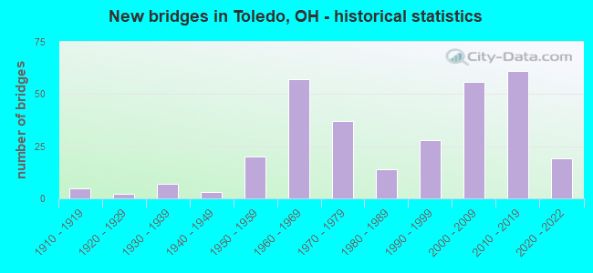
- New bridges - historical statistics
- 51910-1919
- 21920-1929
- 71930-1939
- 31940-1949
- 201950-1959
- 571960-1969
- 371970-1979
- 141980-1989
- 281990-1999
- 562000-2009
- 612010-2019
- 192020-2022

- Reconstructed bridges - Historical Statistics
- 11950-1959
- 01960-1969
- 11970-1979
- 31980-1989
- 111990-1999
- 192000-2009
- 192010-2019
- 52020-2022


- Bridge Condition - Deck
- 32.0%Excellent
- 32.6%Very good
- 23.3%Good
- 7.0%Satisfactory
- 3.5%Fair
- 1.2%Poor
- 0.6%Serious

- Bridge Condition - Superstructure
- 28.2%Excellent
- 26.4%Very good
- 31.6%Good
- 10.9%Satisfactory
- 1.7%Fair
- 1.1%Poor

- Bridge Condition - Substructure
- 25.9%Excellent
- 29.3%Very good
- 33.3%Good
- 10.9%Satisfactory
- 0.6%Poor

- Bridge Condition - Channel
- 24.7%Excellent
- 34.4%Very good
- 24.7%Good
- 12.9%Satisfactory
- 2.2%Fair
- 1.1%Poor

- Bridge Condition - Culverts
- 16.7%Very good
- 55.6%Good
- 27.8%Satisfactory
Find on map >> Show street view
Structure Number: 480622, Location: JCT. IR 280 and SR25 (Lat: 41.674689, Lng: -83.515231), Route carried "under" structure: State highway 25, Year Built: 1988, Structure Length: 0. m, Average Daily Traffic: 12,297 (year 2018), Truck Traffic: 4%, Features Intersected: IR 280
Minimum Vertical Clearance: 4.85m (15.91ft), Kilometerpoint: 18.324, Lanes on structure: 6, Lanes under structure: 4, Material/Design: Steel continuous, Design/Construction: Stringer/Multi-beam, Length of Maximum Span: 28.3m (92.8ft)
Find on map >> Show street view
Structure Number: 4806263, Location: JCT CENTRAL AVE I-280 (Lat: 41.678989, Lng: -83.515661), Route carried "under" structure: Interstate 280, Year Built: 2000, Structure Length: 0. m, Average Daily Traffic: 64,897 (year 2019), Truck Traffic: 11%, Features Intersected: CENTRAL AVENUE
Minimum Vertical Clearance: 5.03m (16.50ft), Kilometerpoint: 7.918, Lanes on structure: 4, Lanes under structure: 4, Material/Design: Steel continuous, Design/Construction: Stringer/Multi-beam, Length of Maximum Span: 27.7m (90.9ft)
Find on map >> Show street view
Structure Number: 4806344, Location: JCT I280 & MANHATTAN BLVD (Lat: 41.687489, Lng: -83.516689), Route carried "under" structure: Interstate 280, Year Built: 2004, Structure Length: 0. m, Average Daily Traffic: 15,896 (year 2019), Truck Traffic: 8%, Features Intersected: MANHATTAN BOULEVARD
Minimum Vertical Clearance: 5.05m (16.57ft), Kilometerpoint: 8.835, Lanes on structure: 5, Lanes under structure: 3, Material/Design: Steel, Design/Construction: Stringer/Multi-beam, Length of Maximum Span: 30.8m (101.0ft)
Find on map >> Show street view
Structure Number: 4806379, Location: JCT I280 & MANHATTAN BLVD (Lat: 41.687550, Lng: -83.515681), Route carried "under" structure: Interstate 280, Year Built: 2004, Structure Length: 0. m, Average Daily Traffic: 27,312 (year 2019), Truck Traffic: 14%, Features Intersected: MANHATTAN BLVD
Minimum Vertical Clearance: 5.03m (16.50ft), Kilometerpoint: 8.835, Lanes on structure: 5, Lanes under structure: 3, Material/Design: Steel continuous, Design/Construction: Stringer/Multi-beam, Length of Maximum Span: 23.2m (76.1ft)
Find on map >> Show street view
Structure Number: 4806433, Location: JCT I 280 SB & I 75 NB (Lat: 41.689200, Lng: -83.516600), Route carried "under" structure: Interstate 280, Year Built: 2004, Structure Length: 0. m, Average Daily Traffic: 16,195 (year 2010), Truck Traffic: 21%, Features Intersected: IR 280 NB RAMP TO SB IR7
Minimum Vertical Clearance: 5.01m (16.44ft), Kilometerpoint: 9.061, Lanes on structure: 1, Lanes under structure: 3, Material/Design: Steel, Design/Construction: Stringer/Multi-beam, Length of Maximum Span: 33.5m (109.9ft)
Find on map >> Show street view
Structure Number: 4807324, Location: 0.23 Mi. N. of IR 80/90 (Lat: 41.595419, Lng: -83.691781), Route carried "under" structure: Interstate 475, Year Built: 1968, Structure Length: 0. m, Average Daily Traffic: 80,199 (year 2019), Truck Traffic: 9%, Features Intersected: CR 84 GARDEN ROAD
Minimum Vertical Clearance: 4.88m (16.01ft), Kilometerpoint: 5.617, Lanes on structure: 2, Lanes under structure: 4, Material/Design: Steel continuous, Design/Construction: Stringer/Multi-beam, Length of Maximum Span: 25.0m (82.0ft)
Find on map >> Show street view
Structure Number: 4807359, Location: 0.56 Mi. N. of IR 80/90 (Lat: 41.599989, Lng: -83.690789), Route carried "under" structure: Interstate 475, Year Built: 1968, Structure Length: 0. m, Average Daily Traffic: 80,199 (year 2019), Truck Traffic: 9%, Features Intersected: C1571-PERRYSBURG HOLLAND
Minimum Vertical Clearance: 5.05m (16.57ft), Kilometerpoint: 6.148, Lanes on structure: 2, Lanes under structure: 4, Material/Design: Steel continuous, Design/Construction: Stringer/Multi-beam, Length of Maximum Span: 36.6m (120.1ft)
Find on map >> Show street view
Structure Number: 4807626, Location: Int. IR 475 & Hill Ave. (Lat: 41.638500, Lng: -83.694711), Route carried "under" structure: County highway C0030, Year Built: 1968, Structure Length: 0. m, Average Daily Traffic: 9,196 (year 2018), Truck Traffic: 2%, Features Intersected: IR 475
Minimum Vertical Clearance: 4.79m (15.72ft), Kilometerpoint: 5.549, Lanes on structure: 3, Lanes under structure: 2, Material/Design: Steel continuous, Design/Construction: Stringer/Multi-beam, Length of Maximum Span: 22.4m (73.5ft)
Find on map >> Show street view
Structure Number: 480765, Location: Int. IR 475 & Hill Ave. (Lat: 41.638489, Lng: -83.694300), Route carried "under" structure: County highway C0030, Year Built: 1968, Structure Length: 0. m, Average Daily Traffic: 9,196 (year 2018), Truck Traffic: 2%, Features Intersected: IR 475
Minimum Vertical Clearance: 4.78m (15.68ft), Kilometerpoint: 5.584, Lanes on structure: 3, Lanes under structure: 2, Material/Design: Steel continuous, Design/Construction: Stringer/Multi-beam, Length of Maximum Span: 22.4m (73.5ft)
Find on map >> Show street view
Structure Number: 4807685, Location: Int. IR 475 & Dorr St. (Lat: 41.653631, Lng: -83.695161), Route carried "under" structure: State highway 246, Year Built: 1968, Structure Length: 0. m, Average Daily Traffic: 7,935 (year 2018), Truck Traffic: 8%, Features Intersected: IR 475
Minimum Vertical Clearance: 5.08m (16.67ft), Kilometerpoint: 10.400, Lanes on structure: 3, Lanes under structure: 2, Material/Design: Steel continuous, Design/Construction: Stringer/Multi-beam, Length of Maximum Span: 22.4m (73.5ft)
Find on map >> Show street view
Structure Number: 4807715, Location: Int. IR 475 & Dorr St. (Lat: 41.653631, Lng: -83.694761), Route carried "under" structure: State highway 246, Year Built: 1968, Structure Length: 0. m, Average Daily Traffic: 7,935 (year 2018), Truck Traffic: 8%, Features Intersected: IR 475
Minimum Vertical Clearance: 5.08m (16.67ft), Kilometerpoint: 10.437, Lanes on structure: 3, Lanes under structure: 2, Material/Design: Steel continuous, Design/Construction: Stringer/Multi-beam, Length of Maximum Span: 22.4m (73.5ft)
Find on map >> Show street view
Structure Number: 4807774, Location: IR 475 & Bancroft St. (Lat: 41.660969, Lng: -83.694531), Route carried "under" structure: Interstate 475, Year Built: 1968, Structure Length: 0. m, Average Daily Traffic: 80,920 (year 2018), Truck Traffic: 9%, Features Intersected: CR 22-BANCROFT STREET
Minimum Vertical Clearance: 4.93m (16.17ft), Kilometerpoint: 12.923, Lanes on structure: 4, Lanes under structure: 4, Material/Design: Steel continuous, Design/Construction: Stringer/Multi-beam, Length of Maximum Span: 25.3m (83.0ft)
Find on map >> Show street view
Structure Number: 4808045, Location: 1.65 MI E - US23 & IR 475 (Lat: 41.689839, Lng: -83.663439), Route carried "under" structure: Interstate 475, Year Built: 1969, Structure Length: 0. m, Average Daily Traffic: 49,660 (year 2010), Truck Traffic: 12%, Features Intersected: M0062 COREY ROAD
Minimum Vertical Clearance: 5.23m (17.16ft), Kilometerpoint: 18.314, Lanes on structure: 2, Lanes under structure: 4, Material/Design: Steel continuous, Design/Construction: Stringer/Multi-beam, Length of Maximum Span: 17.4m (57.1ft)
Find on map >> Show street view
Structure Number: 4808134, Location: 2.65 MI E - US23 & IR 475 (Lat: 41.688039, Lng: -83.644461), Route carried "under" structure: Interstate 475, Year Built: 1968, Structure Length: 0. m, Average Daily Traffic: 52,022 (year 2018), Truck Traffic: 9%, Features Intersected: C0083 TALMADGE ROAD
Minimum Vertical Clearance: 5.01m (16.44ft), Kilometerpoint: 19.924, Lanes on structure: 5, Lanes under structure: 4, Material/Design: Steel continuous, Design/Construction: Stringer/Multi-beam, Length of Maximum Span: 14.6m (47.9ft)
Find on map >> Show street view
Structure Number: 4808169, Location: 3.10 MI E - US23 & IR 475 (Lat: 41.688219, Lng: -83.635611), Route carried "under" structure: Interstate 475, Year Built: 1968, Structure Length: 0. m, Average Daily Traffic: 71,067 (year 2018), Truck Traffic: 9%, Features Intersected: WOODLEY ROAD
Minimum Vertical Clearance: 5.01m (16.44ft), Kilometerpoint: 20.648, Lanes on structure: 2, Lanes under structure: 4, Material/Design: Steel continuous, Design/Construction: Stringer/Multi-beam, Length of Maximum Span: 14.6m (47.9ft)
Find on map >> Show street view
Structure Number: 4808193, Location: 3.75 MI E - US23 & IR 475 (Lat: 41.686550, Lng: -83.623050), Route carried "under" structure: City street C0501, Year Built: 1968, Structure Length: 0. m, Average Daily Traffic: 21,856 (year 2019), Truck Traffic: 4%, Features Intersected: IR 475
Minimum Vertical Clearance: 4.62m (15.16ft), Kilometerpoint: 9.704, Lanes on structure: 4, Lanes under structure: 7, Material/Design: Steel continuous, Design/Construction: Stringer/Multi-beam, Length of Maximum Span: 31.7m (104.0ft)
Find on map >> Show street view
Structure Number: 4808223, Location: 4.15 Mi E - US23 & IR 475 (Lat: 41.685350, Lng: -83.616039), Route carried "under" structure: Interstate 475, Year Built: 1970, Structure Length: 0. m, Average Daily Traffic: 71,290 (year 2019), Truck Traffic: 9%, Features Intersected: RAMP FROM SB 51 TO EB 47
Minimum Vertical Clearance: 5.03m (16.50ft), Kilometerpoint: 22.354, Lanes on structure: 2, Lanes under structure: 4, Material/Design: Steel continuous, Design/Construction: Stringer/Multi-beam, Length of Maximum Span: 21.6m (70.9ft)
Find on map >> Show street view
Structure Number: 4808282, Location: 0.19 Mi. E. of SR 51 (Lat: 41.685489, Lng: -83.610389), Route carried "under" structure: Interstate 475, Year Built: 1970, Structure Length: 0. m, Average Daily Traffic: 80,228 (year 2019), Truck Traffic: 9%, Features Intersected: M0766 BOWEN ROAD
Minimum Vertical Clearance: 5.03m (16.50ft), Kilometerpoint: 22.820, Lanes on structure: 2, Lanes under structure: 6, Material/Design: Steel continuous, Design/Construction: Stringer/Multi-beam, Length of Maximum Span: 18.3m (60.0ft)
Find on map >> Show street view
Structure Number: 4808312, Location: 0.36 Mi E. - SR 51 (Lat: 41.685661, Lng: -83.607361), Route carried "under" structure: Interstate 475, Year Built: 1970, Structure Length: 0. m, Average Daily Traffic: 80,228 (year 2019), Truck Traffic: 9%, Features Intersected: M1899 RUSHLAND AVE
Minimum Vertical Clearance: 5.03m (16.50ft), Kilometerpoint: 23.078, Lanes on structure: 2, Lanes under structure: 6, Material/Design: Steel continuous, Design/Construction: Stringer/Multi-beam, Length of Maximum Span: 18.3m (60.0ft)
Find on map >> Show street view
Structure Number: 4808355, Location: 1/4 MI N SR 51 (Lat: 41.684881, Lng: -83.603719), Route carried "under" structure: Interstate 475, Year Built: 2009, Structure Length: 0. m, Average Daily Traffic: 83,030 (year 2010), Truck Traffic: 11%, Features Intersected: M0502 DOUGLAS ROAD
Minimum Vertical Clearance: 5.51m (18.08ft), Kilometerpoint: 23.384, Lanes on structure: 5, Lanes under structure: 6, Material/Design: Steel continuous, Design/Construction: Stringer/Multi-beam, Length of Maximum Span: 29.3m (96.1ft)
Find on map >> Show street view
Structure Number: 4808444, Location: JCT I-475 & SHERBROOKE RD (Lat: 41.683061, Lng: -83.599619), Route carried "under" structure: Interstate 475, Year Built: 2013, Structure Length: 0. m, Average Daily Traffic: 97,026 (year 2019), Truck Traffic: 9%, Features Intersected: M1962 SHERBROOKE ROAD
Minimum Vertical Clearance: 5.23m (17.16ft), Kilometerpoint: 23.786, Lanes on structure: 2, Lanes under structure: 9, Material/Design: Steel continuous, Design/Construction: Stringer/Multi-beam, Length of Maximum Span: 31.1m (102.0ft)
Find on map >> Show street view
Structure Number: 4808495, Location: 0.7 MI W. of IR 75 (Lat: 41.678100, Lng: -83.587300), Route carried "under" structure: State highway 120, Year Built: 1970, Structure Length: 0. m, Average Daily Traffic: 15,405 (year 2018), Truck Traffic: 4%, Features Intersected: IR 475
Minimum Vertical Clearance: 4.72m (15.49ft), Kilometerpoint: 24.349, Lanes on structure: 8, Lanes under structure: 4, Material/Design: Steel continuous, Design/Construction: Stringer/Multi-beam, Length of Maximum Span: 26.5m (86.9ft)
Find on map >> Show street view
Structure Number: 4808509, Location: JCT I475 & PROMEDICA PKWY (Lat: 41.679531, Lng: -83.591381), Route carried "under" structure: Interstate 475, Year Built: 2013, Structure Length: 0. m, Average Daily Traffic: 97,026 (year 2019), Truck Traffic: 9%, Features Intersected: M9006 PROMEDICA PARKWAY
Minimum Vertical Clearance: 5.08m (16.67ft), Kilometerpoint: 24.575, Lanes on structure: 4, Lanes under structure: 8, Material/Design: Steel continuous, Design/Construction: Stringer/Multi-beam, Length of Maximum Span: 32.3m (106.0ft)
Find on map >> Show street view
Structure Number: 4808525, Location: JCT IR475 & UPTON AVE (Lat: 41.678969, Lng: -83.589339), Route carried "under" structure: County highway C0522, Year Built: 2013, Structure Length: 0. m, Average Daily Traffic: 8,553 (year 2019), Truck Traffic: 8%, Features Intersected: IR 475
Minimum Vertical Clearance: 4.72m (15.49ft), Kilometerpoint: 2.981, Lanes on structure: 8, Lanes under structure: 4, Material/Design: Steel, Design/Construction: Stringer/Multi-beam, Length of Maximum Span: 33.8m (110.9ft)
Find on map >> Show street view
Structure Number: 4808533, Location: JCT I-475 & UPTON AVE (Lat: 41.679439, Lng: -83.589361), Route carried "under" structure: City street C0522, Year Built: 2013, Structure Length: 0. m, Average Daily Traffic: 8,553 (year 2019), Truck Traffic: 8%, Features Intersected: IR 475 Ramp D4
Minimum Vertical Clearance: 4.72m (15.49ft), Kilometerpoint: 10.799, Lanes on structure: 1, Lanes under structure: 4, Material/Design: Steel, Design/Construction: Stringer/Multi-beam, Length of Maximum Span: 37.8m (124.0ft)
Find on map >> Show street view
Structure Number: 4808541, Location: JCT I-475 & UPTON AVE (Lat: 41.678550, Lng: -83.589331), Route carried "under" structure: City street C0522, Year Built: 2013, Structure Length: 0. m, Average Daily Traffic: 8,553 (year 2019), Truck Traffic: 8%, Features Intersected: IR 475 RAMP D6
Minimum Vertical Clearance: 4.72m (15.49ft), Kilometerpoint: 2.876, Lanes on structure: 1, Lanes under structure: 4, Material/Design: Steel, Design/Construction: Stringer/Multi-beam, Length of Maximum Span: 29.9m (98.1ft)
Find on map >> Show street view
Structure Number: 4808584, Location: 0.36 MI W - US23 & IR 475 (Lat: 41.674861, Lng: -83.579411), Route carried "under" structure: Interstate 475, Year Built: 1970, Structure Length: 0. m, Average Daily Traffic: 90,124 (year 2018), Truck Traffic: 9%, Features Intersected: AUBURN AVE.
Minimum Vertical Clearance: 5.11m (16.77ft), Kilometerpoint: 25.669, Lanes on structure: 2, Lanes under structure: 6, Material/Design: Steel continuous, Design/Construction: Stringer/Multi-beam, Length of Maximum Span: 29.0m (95.1ft)
Find on map >> Show street view
Structure Number: 4808681, Location: JCT 475 & 75 (Lat: 41.675381, Lng: -83.575311), Route carried "under" structure: Ramp Interstate 75, Year Built: 2013, Structure Length: 0. m, Average Daily Traffic: 90,150 (year 2018), Truck Traffic: 9%, Features Intersected: IR 475
Minimum Vertical Clearance: 8.59m (28.18ft), Kilometerpoint: 7.403, Lanes on structure: 1, Lanes under structure: 2, Material/Design: Steel continuous, Design/Construction: Stringer/Multi-beam, Length of Maximum Span: 46.9m (153.9ft)
Find on map >> Show street view
Structure Number: 4860004, Location: E. OF SUMMIT (Lat: 41.651139, Lng: -83.526289), Route carried "under" structure: City street 2153, Year Built: 1914, Structure Length: 0. m, Average Daily Traffic: 3,479 (year 2015), Truck Traffic: 5%, Features Intersected: CHERRY ST BRIDGE, Facility Carried by Structure: WATER STREET
Minimum Vertical Clearance: 5.21m (17.09ft), Kilometerpoint: 0.032, Lanes on structure: 5, Lanes under structure: 2, Material/Design: Steel, Design/Construction: Movable - Bascule, Length of Maximum Span: 74.5m (244.4ft)
Find on map >> Show street view
Structure Number: 4860543, Location: .5 MI S OF HILL (Lat: 41.631261, Lng: -83.625919), Route carried "under" structure: City street 209, Year Built: 1954, Structure Length: 0. m, Average Daily Traffic: 1,295 (year 2015), Truck Traffic: 5%, Features Intersected: BYRNE ROAD, Facility Carried by Structure: SOUTH STREET
Minimum Vertical Clearance: 6.71m (22.01ft), Kilometerpoint: 14.548, Lanes on structure: 4, Lanes under structure: 2, Material/Design: Steel continuous, Design/Construction: Stringer/Multi-beam, Length of Maximum Span: 21.9m (71.9ft)
Find on map >> Show street view
Structure Number: 4861116, Location: 0.74 MI N OF DORR STR (Lat: 41.663150, Lng: -83.608381), Route carried "under" structure: City street 1W06, Year Built: 1980, Structure Length: 0. m, Average Daily Traffic: 33 (year 2015), Truck Traffic: 6%, Features Intersected: N. DOUGLAS RD., Facility Carried by Structure: BANCROFT STREET
Minimum Vertical Clearance: 4.67m (15.32ft), Kilometerpoint: 13.728, Lanes on structure: 4, Lanes under structure: 4, Material/Design: Steel continuous, Design/Construction: Stringer/Multi-beam, Length of Maximum Span: 26.2m (86.0ft)
Find on map >> Show street view
Structure Number: 4861175, Location: 2.0 MI E OF CHERRY STREET (Lat: 41.679119, Lng: -83.516900), Route carried "under" structure: City street BKEYE, Year Built: 1958, Structure Length: 0. m, Average Daily Traffic: 100 (year 1951), Features Intersected: E. CENTRAL AVE, Facility Carried by Structure: BUCKEYE STREET
Minimum Vertical Clearance: 6.15m (20.18ft), Kilometerpoint: 0.000, Lanes on structure: 4, Lanes under structure: 2, Material/Design: Steel continuous, Design/Construction: Stringer/Multi-beam, Length of Maximum Span: 14.3m (46.9ft)
Find on map >> Show street view
Structure Number: 4861531, Location: JEEP DRIVE (Lat: 41.698981, Lng: -83.527661), Route carried "under" structure: City street O1W43, Year Built: 2006, Structure Length: 0. m, Average Daily Traffic: 1,295 (year 2015), Truck Traffic: 5%, Features Intersected: JEEP DRIVE, Facility Carried by Structure: STICKNEY AVENUE
Minimum Vertical Clearance: 5.05m (16.57ft), Kilometerpoint: 6.759, Lanes on structure: 2, Lanes under structure: 2, Material/Design: Steel continuous, Design/Construction: Stringer/Multi-beam, Length of Maximum Span: 27.4m (89.9ft)
Find on map >> Show street view
Structure Number: 8729085, Location: 3.7MI EAST OF EXIT 59 (Lat: 41.577431, Lng: -83.601461), Route carried "under" structure: State highway 65, Year Built: 1954, Structure Length: 0. m, Average Daily Traffic: 7,463 (year 2015), Truck Traffic: 3%, Features Intersected: I80 OHIO TPK
Minimum Vertical Clearance: 4.83m (15.85ft), Kilometerpoint: 33.152, Lanes on structure: 2, Lanes under structure: 2, Material/Design: Steel continuous, Design/Construction: Stringer/Multi-beam, Length of Maximum Span: 24.4m (80.1ft)