Bridge Statistics for Toledo, Ohio (OH)
Condition, Traffic, Stress, Structural Evaluation, Project Costs
- National Bridge Inventory (NBI) Statistics
- 309Number of bridges
- 7,083ft / 2,159mTotal length
- $659,445,000Total costs
- 7,287,020Total average daily traffic
- 979,698Total average daily truck traffic
- National Bridge Inventory (NBI) Registered Bridges for Toledo
- No street view available for this location
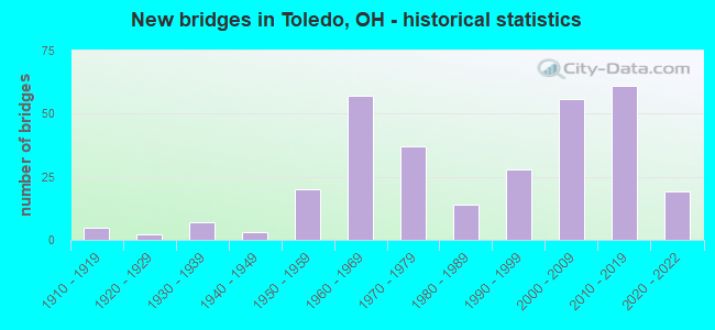
- New bridges - historical statistics
- 51910-1919
- 21920-1929
- 71930-1939
- 31940-1949
- 201950-1959
- 571960-1969
- 371970-1979
- 141980-1989
- 281990-1999
- 562000-2009
- 612010-2019
- 192020-2022

- Reconstructed bridges - Historical Statistics
- 11950-1959
- 01960-1969
- 11970-1979
- 31980-1989
- 111990-1999
- 192000-2009
- 192010-2019
- 52020-2022


- Bridge Condition - Deck
- 32.0%Excellent
- 32.6%Very good
- 23.3%Good
- 7.0%Satisfactory
- 3.5%Fair
- 1.2%Poor
- 0.6%Serious

- Bridge Condition - Superstructure
- 28.2%Excellent
- 26.4%Very good
- 31.6%Good
- 10.9%Satisfactory
- 1.7%Fair
- 1.1%Poor

- Bridge Condition - Substructure
- 25.9%Excellent
- 29.3%Very good
- 33.3%Good
- 10.9%Satisfactory
- 0.6%Poor

- Bridge Condition - Channel
- 24.7%Excellent
- 34.4%Very good
- 24.7%Good
- 12.9%Satisfactory
- 2.2%Fair
- 1.1%Poor

- Bridge Condition - Culverts
- 16.7%Very good
- 55.6%Good
- 27.8%Satisfactory
Find on map >> Show street view
Structure Number: 4808509, Location: JCT I475 & PROMEDICA PKWY (Lat: 41.679531, Lng: -83.591381), Route carried "on" structure: City street M9006, Year Built: 2013, Status: Open, Structure Length: 5.88m (19.29ft), Average Daily Traffic: 12,160 (year 2010), Truck Traffic: 2%, Average Future Daily Traffic: 156,330 (year 2030), Design Load: HS 25 or greater, Features Intersected: IR 475, Facility Carried by Structure: PROMEDICA PKWY
Minimum Vertical Clearance: 30+ m (98+ ft), Kilometerpoint: 0.628, Lanes on structure: 4, Lanes under structure: 8, Owner: State Highway Agency, Approaching Roadway Width: 15.9m (52.2ft), Material/Design: Steel continuous, Design/Construction: Stringer/Multi-beam, Number Of Spans In Main Unit: 2, Length of Maximum Span: 32.3m (106.0ft), Curb or Sidewalk Widths: Left: 2.4m (7.9ft), Right: 2.4m (7.9ft), Curb-To-Curb Width: 15.9m (52.2ft), Out-to-Out Width: 21.3m (69.9ft)
Condition: Deck: Excellent, Superstructure: Very good, Substructure: Very good, Operating Rating: 81.0 metric tons, Method Used To Determine Operating Rating: Load Factor (LF) rating reported by rating factor (RF) method using MS18 loading, Inventory Rating: 77.8 metric tons, Method Used To Determine Inventory Rating: Load Factor (LF) rating reported by rating factor (RF) method using MS18 loading, Structural Evaluation: Equal to present desirable criteria, Deck Geometry: Meets minimum limits, Underclear: Somewhat better than minimum adequacy, Approach Roadway Alignment: Equal to present desirable criteria, Designated Inspection Frequency: Every 24 months, Inspection Date: January 2021, Deck Structure Type: Concrete Cast-file-Place, Wearing Surface/Protective System: Wearing Surface: Monolithic Concrete, Deck Protection: Epoxy Coated Reinforcing
Find on map >> Show street view
Structure Number: 4808525, Location: JCT IR475 & UPTON AVE (Lat: 41.678969, Lng: -83.589339), Route carried "on" structure: Interstate 475, Year Built: 2013, Status: Open, Structure Length: 3.47m (11.38ft), Average Daily Traffic: 97,026 (year 2019), Truck Traffic: 9%, Average Future Daily Traffic: 110,000 (year 2039), Design Load: HS 25 or greater, Features Intersected: UPTON AVENUE
Minimum Vertical Clearance: 30+ m (98+ ft), Kilometerpoint: 24.752, Lanes on structure: 8, Lanes under structure: 4, Base Highway Network: Yes, Owner: State Highway Agency, Approaching Roadway Width: 20.7m (67.9ft), Skew: 33 degrees, Material/Design: Steel, Design/Construction: Stringer/Multi-beam, Number Of Spans In Main Unit: 1, Length of Maximum Span: 33.8m (110.9ft), Curb-To-Curb Width: 47.2m (154.9ft), Out-to-Out Width: 49.1m (161.1ft)
Condition: Deck: Very good, Superstructure: Excellent, Substructure: Excellent, Operating Rating: 81.0 metric tons, Method Used To Determine Operating Rating: Load Factor (LF) rating reported by rating factor (RF) method using MS18 loading, Inventory Rating: 77.8 metric tons, Method Used To Determine Inventory Rating: Load Factor (LF) rating reported by rating factor (RF) method using MS18 loading, Structural Evaluation: Superior to present desirable criteria, Deck Geometry: Superior to present desirable criteria, Underclear: Meets minimum limits, Approach Roadway Alignment: Equal to present desirable criteria, Designated Inspection Frequency: Every 24 months, Inspection Date: January 2021, Deck Structure Type: Concrete Cast-file-Place, Wearing Surface/Protective System: Wearing Surface: Monolithic Concrete, Deck Protection: Epoxy Coated Reinforcing
Find on map >> Show street view
Structure Number: 4808533, Location: JCT I-475 & UPTON AVE (Lat: 41.679439, Lng: -83.589361), Route carried "on" structure: Ramp Interstate 475, Year Built: 2013, Status: Open, Structure Length: 3.84m (12.60ft), Average Daily Traffic: 5,022 (year 2019), Truck Traffic: 3%, Average Future Daily Traffic: 7,634 (year 2039), Design Load: HS 25 or greater, Features Intersected: RAMP D4 OVER UPTON AVENU, Facility Carried by Structure: RAMP D4
Minimum Vertical Clearance: 30+ m (98+ ft), Kilometerpoint: 24.720, Lanes on structure: 1, Lanes under structure: 4, Base Highway Network: Yes, Owner: State Highway Agency, Approaching Roadway Width: 9.1m (29.9ft), Skew: 4 degrees, Material/Design: Steel, Design/Construction: Stringer/Multi-beam, Number Of Spans In Main Unit: 1, Length of Maximum Span: 37.8m (124.0ft), Curb-To-Curb Width: 9.1m (29.9ft), Out-to-Out Width: 10.1m (33.1ft)
Condition: Deck: Very good, Superstructure: Excellent, Substructure: Very good, Operating Rating: 81.0 metric tons, Method Used To Determine Operating Rating: Load Factor (LF) rating reported by rating factor (RF) method using MS18 loading, Inventory Rating: 77.8 metric tons, Method Used To Determine Inventory Rating: Load Factor (LF) rating reported by rating factor (RF) method using MS18 loading, Structural Evaluation: Equal to present desirable criteria, Deck Geometry: Superior to present desirable criteria, Underclear: Somewhat better than minimum adequacy, Approach Roadway Alignment: Equal to present desirable criteria, Designated Inspection Frequency: Every 24 months, Inspection Date: January 2021, Deck Structure Type: Concrete Cast-file-Place, Wearing Surface/Protective System: Wearing Surface: Monolithic Concrete, Deck Protection: Epoxy Coated Reinforcing
Find on map >> Show street view
Structure Number: 4808541, Location: JCT I-475 & UPTON AVE (Lat: 41.678550, Lng: -83.589331), Route carried "on" structure: Ramp Interstate 475, Year Built: 2013, Status: Open, Structure Length: 3.05m (10.01ft), Average Daily Traffic: 5,709 (year 2019), Truck Traffic: 3%, Average Future Daily Traffic: 7,634 (year 2039), Design Load: HS 25 or greater, Features Intersected: RAMP D6 OVER UPTON AVENU, Facility Carried by Structure: RAMP D6
Minimum Vertical Clearance: 30+ m (98+ ft), Kilometerpoint: 24.800, Lanes on structure: 1, Lanes under structure: 4, Base Highway Network: Yes, Owner: State Highway Agency, Approaching Roadway Width: 9.1m (29.9ft), Skew: 1 degrees, Material/Design: Steel, Design/Construction: Stringer/Multi-beam, Number Of Spans In Main Unit: 1, Length of Maximum Span: 29.9m (98.1ft), Curb-To-Curb Width: 9.1m (29.9ft), Out-to-Out Width: 10.1m (33.1ft)
Condition: Deck: Very good, Superstructure: Excellent, Substructure: Excellent, Operating Rating: 81.0 metric tons, Method Used To Determine Operating Rating: Load Factor (LF) rating reported by rating factor (RF) method using MS18 loading, Inventory Rating: 77.8 metric tons, Method Used To Determine Inventory Rating: Load Factor (LF) rating reported by rating factor (RF) method using MS18 loading, Structural Evaluation: Superior to present desirable criteria, Deck Geometry: Superior to present desirable criteria, Underclear: Meets minimum limits, Approach Roadway Alignment: Equal to present desirable criteria, Designated Inspection Frequency: Every 24 months, Inspection Date: January 2021, Deck Structure Type: Concrete Cast-file-Place, Wearing Surface/Protective System: Wearing Surface: Monolithic Concrete, Deck Protection: Epoxy Coated Reinforcing
Find on map >> Show street view
Structure Number: 4808584, Location: 0.36 MI W - US23 & IR 475 (Lat: 41.674861, Lng: -83.579411), Route carried "on" structure: City street M0661, Year Built: 1970, Year Reconstructed: 2010, Status: Open, Structure Length: 13.32m (43.70ft), Average Daily Traffic: 3,975 (year 2018), Truck Traffic: 2%, Average Future Daily Traffic: 4,000 (year 2038), Design Load: HS 20+Mod, Features Intersected: IR 475, Facility Carried by Structure: AUBURN AVE.
Minimum Vertical Clearance: 30+ m (98+ ft), Kilometerpoint: 1.463, Lanes on structure: 2, Lanes under structure: 6, Owner: State Highway Agency, Approaching Roadway Width: 15.9m (52.2ft), Material/Design: Steel continuous, Design/Construction: Stringer/Multi-beam, Number Of Spans In Main Unit: 5, Length of Maximum Span: 29.0m (95.1ft), Curb or Sidewalk Widths: Left: 1.8m (5.9ft), Right: 1.8m (5.9ft), Curb-To-Curb Width: 12.2m (40.0ft), Out-to-Out Width: 16.6m (54.5ft)
Condition: Deck: Very good, Superstructure: Good, Substructure: Very good, Channel: Satisfactory, Operating Rating: 42.1 metric tons, Method Used To Determine Operating Rating: Load Factor (LF) rating reported by rating factor (RF) method using MS18 loading, Inventory Rating: 32.4 metric tons, Method Used To Determine Inventory Rating: Load Factor (LF) rating reported by rating factor (RF) method using MS18 loading, Structural Evaluation: Better than present minimum criteria, Deck Geometry: Equal to present minimum criteria, Underclear: Meets minimum limits, Waterway Adequacy: Equal to present desirable criteria, Approach Roadway Alignment: Equal to present desirable criteria, Designated Inspection Frequency: Every 24 months, Inspection Date: Febuary 2021, Deck Structure Type: Concrete Cast-file-Place, Wearing Surface/Protective System: Wearing Surface: Monolithic Concrete, Deck Protection: Epoxy Coated Reinforcing
Find on map >> Show street view
Structure Number: 4808614, Location: 0.30 MI W - US23 & IR 475 (Lat: 41.675761, Lng: -83.576831), Route carried "on" structure: Interstate 475, Year Built: 1970, Year Reconstructed: 2013, Status: Open, Structure Length: 8.90m (29.20ft), Average Daily Traffic: 47,730 (year 2010), Truck Traffic: 12%, Average Future Daily Traffic: 66,249 (year 2030), Design Load: HS 20, Features Intersected: OTTAWA RIVER
Minimum Vertical Clearance: 30+ m (98+ ft), Kilometerpoint: 25.782, Lanes on structure: 2, Base Highway Network: Yes, Owner: State Highway Agency, Approaching Roadway Width: 15.5m (50.9ft), Skew: 6 degrees, Material/Design: Steel continuous, Design/Construction: Stringer/Multi-beam, Number Of Spans In Main Unit: 4, Length of Maximum Span: 24.4m (80.1ft), Curb-To-Curb Width: 15.2m (49.9ft), Out-to-Out Width: 16.6m (54.5ft)
Condition: Deck: Very good, Superstructure: Excellent, Substructure: Very good, Channel: Good, Operating Rating: 42.1 metric tons, Method Used To Determine Operating Rating: Allowable Stress (AS) rating reported by rating factor (RF) method using MS18 loading, Inventory Rating: 32.4 metric tons, Method Used To Determine Inventory Rating: Allowable Stress (AS) rating reported by rating factor (RF) method using MS18 loading, Structural Evaluation: Equal to present desirable criteria, Deck Geometry: Superior to present desirable criteria, Waterway Adequacy: Equal to present desirable criteria, Approach Roadway Alignment: Equal to present desirable criteria, Designated Inspection Frequency: Every 24 months, Inspection Date: Febuary 2021, Deck Structure Type: Concrete Cast-file-Place, Wearing Surface/Protective System: Wearing Surface: Monolithic Concrete
Find on map >> Show street view
Structure Number: 4808649, Location: 0.30 MI W - US23 & IR 475 (Lat: 41.675331, Lng: -83.578181), Route carried "on" structure: Interstate 475, Year Built: 1970, Year Reconstructed: 2013, Status: Open, Structure Length: 10.42m (34.19ft), Average Daily Traffic: 47,730 (year 2010), Truck Traffic: 12%, Average Future Daily Traffic: 66,249 (year 2030), Design Load: HS 20, Features Intersected: OTTAWA RIVER
Minimum Vertical Clearance: 30+ m (98+ ft), Kilometerpoint: 25.782, Lanes on structure: 3, Base Highway Network: Yes, Owner: State Highway Agency, Approaching Roadway Width: 18.9m (62.0ft), Skew: 5 degrees, Material/Design: Steel continuous, Design/Construction: Stringer/Multi-beam, Number Of Spans In Main Unit: 5, Length of Maximum Span: 22.6m (74.1ft), Curb-To-Curb Width: 18.9m (62.0ft), Out-to-Out Width: 25.0m (82.0ft)
Condition: Deck: Very good, Superstructure: Very good, Substructure: Very good, Channel: Good, Operating Rating: 42.1 metric tons, Method Used To Determine Operating Rating: Allowable Stress (AS) rating reported by rating factor (RF) method using MS18 loading, Inventory Rating: 32.4 metric tons, Method Used To Determine Inventory Rating: Allowable Stress (AS) rating reported by rating factor (RF) method using MS18 loading, Structural Evaluation: Equal to present desirable criteria, Deck Geometry: Superior to present desirable criteria, Waterway Adequacy: Equal to present desirable criteria, Approach Roadway Alignment: Equal to present desirable criteria, Designated Inspection Frequency: Every 24 months, Inspection Date: Febuary 2021, Deck Structure Type: Concrete Cast-file-Place, Wearing Surface/Protective System: Wearing Surface: Monolithic Concrete
Find on map >> Show street view
Structure Number: 4808681, Location: JCT 475 & 75 (Lat: 41.675381, Lng: -83.575311), Route carried "on" structure: Interstate 475, Year Built: 2013, Status: Open, Structure Length: 13.75m (45.11ft), Average Daily Traffic: 19,646 (year 2018), Truck Traffic: 15%, Average Future Daily Traffic: 40,682 (year 2038), Design Load: HS 25 or greater, Features Intersected: W-N OVER W-S AND IR-75 S
Minimum Vertical Clearance: 30+ m (98+ ft), Kilometerpoint: 26.039, Lanes on structure: 1, Lanes under structure: 2, Base Highway Network: Yes, Owner: State Highway Agency, Approaching Roadway Width: 16.2m (53.1ft), Skew: 9 degrees, Material/Design: Steel continuous, Design/Construction: Stringer/Multi-beam, Number Of Spans In Main Unit: 3, Length of Maximum Span: 46.9m (153.9ft), Curb-To-Curb Width: 16.2m (53.1ft), Out-to-Out Width: 17.1m (56.1ft)
Condition: Deck: Excellent, Superstructure: Excellent, Substructure: Very good, Operating Rating: 81.0 metric tons, Method Used To Determine Operating Rating: Load Factor (LF) rating reported by rating factor (RF) method using MS18 loading, Inventory Rating: 77.8 metric tons, Method Used To Determine Inventory Rating: Load Factor (LF) rating reported by rating factor (RF) method using MS18 loading, Structural Evaluation: Equal to present desirable criteria, Deck Geometry: Superior to present desirable criteria, Underclear: Better than present minimum criteria, Approach Roadway Alignment: Equal to present desirable criteria, Designated Inspection Frequency: Every 24 months, Inspection Date: Febuary 2021, Deck Structure Type: Concrete Cast-file-Place, Wearing Surface/Protective System: Wearing Surface: Monolithic Concrete, Deck Protection: Epoxy Coated Reinforcing
Find on map >> Show street view
Structure Number: 4831586, Location: .02 MI. S. OF GIBSON (Lat: 41.716719, Lng: -83.526150), Route carried "on" structure: County highway C0746, Year Built: 1951, Status: Posted for load, Structure Length: 0.82m (2.69ft), Average Daily Traffic: 1,295 (year 2015), Truck Traffic: 5%, Average Future Daily Traffic: 1,797 (year 2035), Design Load: H 15, Features Intersected: SHANTEE CREEK 1802, Facility Carried by Structure: OMAR RD.
Minimum Vertical Clearance: 30+ m (98+ ft), Kilometerpoint: 0.435, Lanes on structure: 2, Owner: County Highway Agency, Approaching Roadway Width: 9.1m (29.9ft), Material/Design: Concrete, Design/Construction: Culvert, Number Of Spans In Main Unit: 3, Length of Maximum Span: 2.1m (6.9ft)
Condition: Channel: Very good, Culverts: Satisfactory, Operating Rating: 35.6 metric tons, Method Used To Determine Operating Rating: Load Factor (LF) rating reported by rating factor (RF) method using MS18 loading, Inventory Rating: 22.7 metric tons, Method Used To Determine Inventory Rating: Load Factor (LF) rating reported by rating factor (RF) method using MS18 loading, Structural Evaluation: Equal to present minimum criteria, Waterway Adequacy: Better than present minimum criteria, Approach Roadway Alignment: Better than present minimum criteria, Bridge Posting: Required (Relationship of Operating Rating to Maximum Legal Load: 0.1 - 9.9% below), Designated Inspection Frequency: Every 12 months, Inspection Date: November 2021
Find on map >> Show street view
Structure Number: 4831713, Location: 0.46 M. W. OF WHITEFORD (Lat: 41.690989, Lng: -83.673631), Route carried "on" structure: County highway C0005, Year Built: 1993, Year Reconstructed: 2013, Status: Open, Structure Length: 5.06m (16.60ft), Average Daily Traffic: 8,520 (year 2015), Truck Traffic: 7%, Average Future Daily Traffic: 11,826 (year 2035), Design Load: HS 20, Features Intersected: OTTAWA RIVER 0109, Facility Carried by Structure: SYLVANIA AVENUE
Minimum Vertical Clearance: 30+ m (98+ ft), Kilometerpoint: 17.059, Lanes on structure: 4, Owner: County Highway Agency, Approaching Roadway Width: 16.5m (54.1ft), Skew: 1 degrees, Material/Design: Prestressed concrete continuous, Design/Construction: Stringer/Multi-beam, Number Of Spans In Main Unit: 2, Length of Maximum Span: 24.4m (80.1ft), Curb or Sidewalk Widths: Left: 1.2m (3.9ft), Right: 2.4m (7.9ft), Curb-To-Curb Width: 16.7m (54.8ft), Out-to-Out Width: 21.4m (70.2ft)
Condition: Deck: Excellent, Superstructure: Very good, Substructure: Excellent, Channel: Very good, Operating Rating: 42.1 metric tons, Method Used To Determine Operating Rating: Load Factor (LF) rating reported by rating factor (RF) method using MS18 loading, Inventory Rating: 32.4 metric tons, Method Used To Determine Inventory Rating: Load Factor (LF) rating reported by rating factor (RF) method using MS18 loading, Structural Evaluation: Equal to present desirable criteria, Deck Geometry: Somewhat better than minimum adequacy, Waterway Adequacy: Superior to present desirable criteria, Approach Roadway Alignment: Superior to present desirable criteria, Length Of Structure Improvement: 1.31m (4.30ft), Designated Inspection Frequency: Every 24 months, Inspection Date: November 2021, Roadway Improvement Cost: $6,000, Total Project Cost: $94,000, Deck Structure Type: Concrete Cast-file-Place, Wearing Surface/Protective System: Wearing Surface: Integral Concrete, Deck Protection: Epoxy Coated Reinforcing
Find on map >> Show street view
Structure Number: 4831748, Location: 0.08 MI. S. OF NEBRASKA (Lat: 41.645600, Lng: -83.703611), Route carried "on" structure: County highway C0073, Year Built: 1977, Status: Open, Structure Length: 0.91m (2.99ft), Average Daily Traffic: 11,268 (year 2015), Truck Traffic: 7%, Average Future Daily Traffic: 15,640 (year 2035), Design Load: HS 20, Features Intersected: HELDMAN DITCH 0529, Facility Carried by Structure: MCCORD RD.
Minimum Vertical Clearance: 30+ m (98+ ft), Kilometerpoint: 3.734, Lanes on structure: 2, Owner: County Highway Agency, Approaching Roadway Width: 13.4m (44.0ft), Skew: 4 degrees, Material/Design: Concrete, Design/Construction: Culvert, Number Of Spans In Main Unit: 2, Length of Maximum Span: 3.7m (12.1ft)
Condition: Channel: Very good, Culverts: Good, Operating Rating: 42.1 metric tons, Method Used To Determine Operating Rating: Load Factor (LF) rating reported by rating factor (RF) method using MS18 loading, Inventory Rating: 32.4 metric tons, Method Used To Determine Inventory Rating: Load Factor (LF) rating reported by rating factor (RF) method using MS18 loading, Structural Evaluation: Better than present minimum criteria, Waterway Adequacy: Superior to present desirable criteria, Approach Roadway Alignment: Superior to present desirable criteria, Designated Inspection Frequency: Every 24 months, Inspection Date: October 2021
Find on map >> Show street view
Structure Number: 4832043, Location: 0.37 MI. E. OF MCCORD RD. (Lat: 41.638739, Lng: -83.695050), Route carried "on" structure: County highway C0030, Year Built: 1982, Status: Open, Structure Length: 0.73m (2.40ft), Average Daily Traffic: 7,310 (year 2015), Truck Traffic: 8%, Average Future Daily Traffic: 10,146 (year 2035), Design Load: HS 20+Mod, Features Intersected: HELDMAN DITCH 0538, Facility Carried by Structure: HILL AVENUE
Minimum Vertical Clearance: 30+ m (98+ ft), Kilometerpoint: 5.520, Lanes on structure: 2, Owner: County Highway Agency, Approaching Roadway Width: 13.4m (44.0ft), Material/Design: Concrete, Design/Construction: Frame, Number Of Spans In Main Unit: 2, Length of Maximum Span: 3.4m (11.2ft), Curb-To-Curb Width: 13.4m (44.0ft), Out-to-Out Width: 21.9m (71.9ft)
Condition: Deck: Very good, Superstructure: Very good, Substructure: Good, Channel: Good, Operating Rating: 48.6 metric tons, Method Used To Determine Operating Rating: Load Factor (LF) rating reported by rating factor (RF) method using MS18 loading, Inventory Rating: 38.9 metric tons, Method Used To Determine Inventory Rating: Load Factor (LF) rating reported by rating factor (RF) method using MS18 loading, Structural Evaluation: Better than present minimum criteria, Deck Geometry: Equal to present minimum criteria, Waterway Adequacy: Equal to present desirable criteria, Approach Roadway Alignment: Superior to present desirable criteria, Designated Inspection Frequency: Every 24 months, Inspection Date: October 2021, Deck Structure Type: Concrete Cast-file-Place, Wearing Surface/Protective System: Wearing Surface: Bituminous
Find on map >> Show street view
Structure Number: 4832094, Location: 0.1 MI. S. OF NEBRASKA (Lat: 41.645389, Lng: -83.702469), Route carried "on" structure: County highway T0985, Year Built: 1982, Status: Open, Structure Length: 0.73m (2.40ft), Average Daily Traffic: 1,949 (year 2015), Truck Traffic: 5%, Average Future Daily Traffic: 2,705 (year 2035), Features Intersected: HELDMAN DITCH 2411, Facility Carried by Structure: BANQUOT RD.
Minimum Vertical Clearance: 30+ m (98+ ft), Kilometerpoint: 38.801, Lanes on structure: 2, Owner: County Highway Agency, Approaching Roadway Width: 16.2m (53.1ft), Skew: 2 degrees, Material/Design: Concrete, Design/Construction: Culvert, Number Of Spans In Main Unit: 2, Length of Maximum Span: 3.0m (9.8ft)
Condition: Channel: Good, Culverts: Good, Operating Rating: 42.1 metric tons, Method Used To Determine Operating Rating: Load Factor (LF) rating reported by rating factor (RF) method using MS18 loading, Inventory Rating: 32.4 metric tons, Method Used To Determine Inventory Rating: Load Factor (LF) rating reported by rating factor (RF) method using MS18 loading, Structural Evaluation: Better than present minimum criteria, Waterway Adequacy: Equal to present minimum criteria, Approach Roadway Alignment: Superior to present desirable criteria, Designated Inspection Frequency: Every 24 months, Inspection Date: November 2021
Find on map >> Show street view
Structure Number: 4832132, Location: 0.1 MI. S. OF NEBRASKA (Lat: 41.645411, Lng: -83.701500), Route carried "on" structure: County highway T0992, Year Built: 1982, Status: Open, Structure Length: 0.70m (2.30ft), Average Daily Traffic: 1,295 (year 2015), Truck Traffic: 5%, Average Future Daily Traffic: 1,797 (year 2035), Features Intersected: HELDMAN DITCH 2412, Facility Carried by Structure: DORCAS RD.
Minimum Vertical Clearance: 30+ m (98+ ft), Kilometerpoint: 38.817, Lanes on structure: 1, Owner: County Highway Agency, Approaching Roadway Width: 3.7m (12.1ft), Material/Design: Concrete, Design/Construction: Culvert, Number Of Spans In Main Unit: 2, Length of Maximum Span: 3.0m (9.8ft)
Condition: Channel: Very good, Culverts: Good, Operating Rating: 42.1 metric tons, Method Used To Determine Operating Rating: Load Factor (LF) rating reported by rating factor (RF) method using MS18 loading, Inventory Rating: 32.4 metric tons, Method Used To Determine Inventory Rating: Load Factor (LF) rating reported by rating factor (RF) method using MS18 loading, Structural Evaluation: Better than present minimum criteria, Waterway Adequacy: Equal to present minimum criteria, Approach Roadway Alignment: Superior to present desirable criteria, Designated Inspection Frequency: Every 24 months, Inspection Date: November 2021
Find on map >> Show street view
Structure Number: 4832264, Location: 0.4 MI. N. OF BANCROFT ST (Lat: 41.666389, Lng: -83.697500), Route carried "on" structure: County highway T0915, Year Built: 1984, Status: Open, Structure Length: 0.70m (2.30ft), Average Daily Traffic: 1,949 (year 2015), Truck Traffic: 5%, Average Future Daily Traffic: 2,705 (year 2035), Design Load: HS 20+Mod, Features Intersected: HILL DITCH 1770, Facility Carried by Structure: WILFORD RD.
Minimum Vertical Clearance: 30+ m (98+ ft), Kilometerpoint: 28.485, Lanes on structure: 2, Owner: County Highway Agency, Approaching Roadway Width: 12.2m (40.0ft), Skew: 3 degrees, Material/Design: Prestressed concrete, Design/Construction: Box Beam or Girders - Multiple, Number Of Spans In Main Unit: 1, Length of Maximum Span: 6.1m (20.0ft), Curb-To-Curb Width: 12.2m (40.0ft), Out-to-Out Width: 12.2m (40.0ft)
Condition: Deck: Very good, Superstructure: Very good, Substructure: Very good, Channel: Excellent, Operating Rating: 42.1 metric tons, Method Used To Determine Operating Rating: Load Factor (LF) rating reported by rating factor (RF) method using MS18 loading, Inventory Rating: 32.4 metric tons, Method Used To Determine Inventory Rating: Load Factor (LF) rating reported by rating factor (RF) method using MS18 loading, Structural Evaluation: Equal to present desirable criteria, Deck Geometry: Better than present minimum criteria, Waterway Adequacy: Superior to present desirable criteria, Approach Roadway Alignment: Superior to present desirable criteria, Designated Inspection Frequency: Every 24 months, Inspection Date: October 2021, Deck Structure Type: Concrete Cast-file-Place, Wearing Surface/Protective System: Wearing Surface: Monolithic Concrete, Deck Protection: Epoxy Coated Reinforcing
Find on map >> Show street view
Structure Number: 4832744, Location: 0.04 MI. S. OF SILVER DR. (Lat: 41.721439, Lng: -83.528061), Route carried "on" structure: County highway C0169, Year Built: 1999, Status: Open, Structure Length: 0.67m (2.20ft), Average Daily Traffic: 10,211 (year 2015), Truck Traffic: 5%, Average Future Daily Traffic: 14,173 (year 2035), Design Load: HS 20+Mod, Features Intersected: SILVER CREEK 1509, Facility Carried by Structure: STICKNEY AVENUE
Minimum Vertical Clearance: 30+ m (98+ ft), Kilometerpoint: 0.418, Lanes on structure: 2, Owner: County Highway Agency, Approaching Roadway Width: 9.8m (32.2ft), Material/Design: Concrete, Design/Construction: Frame, Number Of Spans In Main Unit: 1, Length of Maximum Span: 6.4m (21.0ft), Curb or Sidewalk Widths: Left: 0.0m, Right: 1.2m (3.9ft), Curb-To-Curb Width: 9.6m (31.5ft), Out-to-Out Width: 15.2m (49.9ft)
Condition: Deck: Very good, Superstructure: Excellent, Substructure: Excellent, Channel: Excellent, Operating Rating: 42.1 metric tons, Method Used To Determine Operating Rating: Allowable Stress (AS) rating reported by rating factor (RF) method using MS18 loading, Inventory Rating: 32.4 metric tons, Method Used To Determine Inventory Rating: Allowable Stress (AS) rating reported by rating factor (RF) method using MS18 loading, Structural Evaluation: Equal to present desirable criteria, Deck Geometry: High priority of corrective action, Waterway Adequacy: Superior to present desirable criteria, Approach Roadway Alignment: Superior to present desirable criteria, Designated Inspection Frequency: Every 24 months, Inspection Date: November 2021, Deck Structure Type: Concrete Cast-file-Place, Wearing Surface/Protective System: Wearing Surface: Bituminous, Membrane: Preformed Fabric, Deck Protection: Other
Find on map >> Show street view
Structure Number: 486, Location: 0.04M SW ROHR BLVD (Lat: 41.610150, Lng: -83.590111), Route carried "on" structure: City street M1W20, Year Built: 2014, Status: Open, Structure Length: 2.23m (7.32ft), Average Daily Traffic: 2,692 (year 2015), Truck Traffic: 5%, Average Future Daily Traffic: 3,736 (year 2035), Design Load: HL 93, Features Intersected: Delaware Creek 1277, Facility Carried by Structure: River Road
Minimum Vertical Clearance: 6.10m (20.01ft), Kilometerpoint: 16.914, Lanes on structure: 2, Owner: County Highway Agency, Approaching Roadway Width: 9.8m (32.2ft), Skew: 1 degrees, Material/Design: Steel continuous, Design/Construction: Stringer/Multi-beam, Number Of Spans In Main Unit: 1, Length of Maximum Span: 21.6m (70.9ft), Curb or Sidewalk Widths: Left: 1.5m (4.9ft), Right: 1.5m (4.9ft), Curb-To-Curb Width: 9.8m (32.2ft), Out-to-Out Width: 13.4m (44.0ft)
Condition: Deck: Very good, Superstructure: Excellent, Substructure: Excellent, Channel: Excellent, Operating Rating: 45.4 metric tons, Method Used To Determine Operating Rating: Load and Resistance Factor Rating (LRFR) rating reported by rating factor(RF) method using HL-93 loadings, Inventory Rating: 35.6 metric tons, Method Used To Determine Inventory Rating: Load and Resistance Factor Rating (LRFR) rating reported by rating factor(RF) method using HL-93 loadings, Structural Evaluation: Superior to present desirable criteria, Deck Geometry: Meets minimum limits, Waterway Adequacy: Superior to present desirable criteria, Approach Roadway Alignment: Better than present minimum criteria, Length Of Structure Improvement: 2.23m (7.32ft), Designated Inspection Frequency: Every 24 months, Inspection Date: November 2021, Roadway Improvement Cost: $75,000, Total Project Cost: $1,011,000 ( Estimate for 2014), Deck Structure Type: Concrete Cast-file-Place, Wearing Surface/Protective System: Wearing Surface: Monolithic Concrete, Membrane: Epoxy, Deck Protection: Epoxy Coated Reinforcing
Find on map >> Show street view
Structure Number: 4860004, Location: E. OF SUMMIT (Lat: 41.651139, Lng: -83.526289), Route carried "on" structure: County highway 500, Year Built: 1914, Year Reconstructed: 2008, Status: Open, Structure Length: 37.74m (123.82ft), Average Daily Traffic: 9,536 (year 2015), Truck Traffic: 7%, Average Future Daily Traffic: 13,236 (year 2035), Design Load: HS 25 or greater, Features Intersected: MAUMEE RIVER AND WATER S, Facility Carried by Structure: CHERRY STREET
Minimum Vertical Clearance: 30+ m (98+ ft), Kilometerpoint: 4.181, Lanes on structure: 5, Lanes under structure: 2, Owner: City or Municipal Highway Agency, Approaching Roadway Width: 19.5m (64.0ft), Navigation Control: Yes ( Vertical Clearance: 9.4m (30.8ft), Horizontal Clearance: 61.0m (200.1ft)), Material/Design: Steel, Design/Construction: Movable - Bascule, Number Of Spans In Main Unit: 1, Number Of Approach Spans: 10, Length of Maximum Span: 74.5m (244.4ft), Curb or Sidewalk Widths: Left: 2.4m (7.9ft), Right: 2.4m (7.9ft), Curb-To-Curb Width: 19.5m (64.0ft), Out-to-Out Width: 25.5m (83.7ft)
Condition: Deck: Good, Superstructure: Satisfactory, Substructure: Satisfactory, Channel: Satisfactory, Operating Rating: 74.5 metric tons, Method Used To Determine Operating Rating: Load Factor (LF) rating reported by rating factor (RF) method using MS18 loading, Inventory Rating: 45.4 metric tons, Method Used To Determine Inventory Rating: Load Factor (LF) rating reported by rating factor (RF) method using MS18 loading, Structural Evaluation: Equal to present minimum criteria, Deck Geometry: Meets minimum limits, Underclear: Better than present minimum criteria, Waterway Adequacy: Superior to present desirable criteria, Approach Roadway Alignment: Equal to present desirable criteria, Designated Inspection Frequency: Every 12 months, Underwater Inspection Frequency: Every 60 months, Other Special Inspection Frequency: Every 60 months, Inspection Date: August 2021, Underwater Inspection Date: April 2021, Other Special Inspection Date: November 2018, Deck Structure Type: Closed Grating, Wearing Surface/Protective System: Wearing Surface: Integral Concrete
Find on map >> Show street view
Structure Number: 4860063, Location: .2 M N OF AIRPORT/WESTERN (Lat: 41.636669, Lng: -83.567500), Route carried "on" structure: City street M0631, Year Built: 2000, Status: Open, Structure Length: 3.72m (12.20ft), Average Daily Traffic: 944 (year 2015), Truck Traffic: 5%, Average Future Daily Traffic: 1,310 (year 2035), Design Load: HS 20+Mod, Features Intersected: SWAN CREEK, Facility Carried by Structure: HAWLEY ST
Minimum Vertical Clearance: 30+ m (98+ ft), Kilometerpoint: 12.987, Lanes on structure: 2, Owner: City or Municipal Highway Agency, Approaching Roadway Width: 7.9m (25.9ft), Skew: 2 degrees, Material/Design: Prestressed concrete, Design/Construction: Stringer/Multi-beam, Number Of Spans In Main Unit: 1, Length of Maximum Span: 36.0m (118.1ft), Curb or Sidewalk Widths: Left: 1.5m (4.9ft), Right: 1.5m (4.9ft), Curb-To-Curb Width: 7.8m (25.6ft), Out-to-Out Width: 11.4m (37.4ft)
Condition: Deck: Good, Superstructure: Good, Substructure: Very good, Operating Rating: 74.5 metric tons, Method Used To Determine Operating Rating: Load Factor (LF) rating reported by rating factor (RF) method using MS18 loading, Inventory Rating: 45.4 metric tons, Method Used To Determine Inventory Rating: Load Factor (LF) rating reported by rating factor (RF) method using MS18 loading, Structural Evaluation: Better than present minimum criteria, Deck Geometry: Meets minimum limits, Waterway Adequacy: Superior to present desirable criteria, Approach Roadway Alignment: Equal to present minimum criteria, Designated Inspection Frequency: Every 24 months, Inspection Date: November 2021, Deck Structure Type: Concrete Cast-file-Place, Wearing Surface/Protective System: Wearing Surface: Monolithic Concrete, Membrane: Epoxy, Deck Protection: Epoxy Coated Reinforcing
Find on map >> Show street view
Structure Number: 4860071, Location: BENORE E OF SUDER (Lat: 41.713661, Lng: -83.503161), Route carried "on" structure: City street 1W62, Year Built: 1957, Status: Open, Structure Length: 6.19m (20.31ft), Average Daily Traffic: 12,889 (year 2015), Truck Traffic: 5%, Average Future Daily Traffic: 17,890 (year 2035), Design Load: H 20, Features Intersected: GRAND TRUNK WESTERN RR, Facility Carried by Structure: BENORE
Minimum Vertical Clearance: 30+ m (98+ ft), Kilometerpoint: 0.505, Lanes on structure: 4, Owner: City or Municipal Highway Agency, Approaching Roadway Width: 18.3m (60.0ft), Skew: 24 degrees, Material/Design: Steel continuous, Design/Construction: Stringer/Multi-beam, Number Of Spans In Main Unit: 3, Length of Maximum Span: 22.9m (75.1ft), Curb-To-Curb Width: 17.1m (56.1ft), Out-to-Out Width: 19.0m (62.3ft)
Condition: Deck: Fair, Superstructure: Satisfactory, Substructure: Satisfactory, Operating Rating: 97.2 metric tons, Method Used To Determine Operating Rating: Load Factor (LF) rating reported by rating factor (RF) method using MS18 loading, Inventory Rating: 58.3 metric tons, Method Used To Determine Inventory Rating: Load Factor (LF) rating reported by rating factor (RF) method using MS18 loading, Structural Evaluation: Equal to present minimum criteria, Deck Geometry: Somewhat better than minimum adequacy, Underclear: Equal to present minimum criteria, Approach Roadway Alignment: Equal to present desirable criteria, Designated Inspection Frequency: Every 12 months, Inspection Date: November 2021, Deck Structure Type: Concrete Cast-file-Place, Wearing Surface/Protective System: Wearing Surface: Bituminous, Membrane: Built-up
Find on map >> Show street view
Structure Number: 4860101, Location: SUMMIT ST AT CITY LIMITS (Lat: 41.724281, Lng: -83.479439), Route carried "on" structure: City street M1W20, Year Built: 1940, Year Reconstructed: 2005, Status: Open, Structure Length: 12.74m (41.80ft), Average Daily Traffic: 3,252 (year 2015), Truck Traffic: 7%, Average Future Daily Traffic: 4,514 (year 2035), Design Load: HS 20+Mod, Features Intersected: OTTAWA RIVER 0352, Facility Carried by Structure: SUMMIT STREET
Minimum Vertical Clearance: 30+ m (98+ ft), Kilometerpoint: 5.665, Lanes on structure: 4, Owner: City or Municipal Highway Agency, Approaching Roadway Width: 17.1m (56.1ft), Material/Design: Steel continuous, Design/Construction: Stringer/Multi-beam, Number Of Spans In Main Unit: 6, Length of Maximum Span: 24.4m (80.1ft), Curb or Sidewalk Widths: Left: 1.8m (5.9ft), Right: 1.8m (5.9ft), Curb-To-Curb Width: 17.1m (56.1ft), Out-to-Out Width: 21.8m (71.5ft)
Condition: Deck: Excellent, Superstructure: Excellent, Substructure: Very good, Channel: Excellent, Operating Rating: 43.4 metric tons, Method Used To Determine Operating Rating: Load Factor (LF) rating reported by rating factor (RF) method using MS18 loading, Inventory Rating: 25.9 metric tons, Method Used To Determine Inventory Rating: Load Factor (LF) rating reported by rating factor (RF) method using MS18 loading, Structural Evaluation: Equal to present minimum criteria, Deck Geometry: Somewhat better than minimum adequacy, Waterway Adequacy: Equal to present desirable criteria, Approach Roadway Alignment: Superior to present desirable criteria, Length Of Structure Improvement: 24.38m (79.99ft), Designated Inspection Frequency: Every 24 months, Underwater Inspection Frequency: Every 60 months, Inspection Date: November 2021, Underwater Inspection Date: July 2017, Roadway Improvement Cost: $961,000, Total Project Cost: $4,739,000, Deck Structure Type: Concrete Cast-file-Place, Wearing Surface/Protective System: Wearing Surface: Monolithic Concrete, Deck Protection: Epoxy Coated Reinforcing
Find on map >> Show street view
Structure Number: 4860128, Location: BERDAN E OF I75 (Lat: 41.687989, Lng: -83.561350), Route carried "on" structure: City street 1W02, Year Built: 1972, Status: Open, Structure Length: 3.05m (10.01ft), Average Daily Traffic: 10,885 (year 2015), Truck Traffic: 7%, Average Future Daily Traffic: 15,108 (year 2035), Design Load: HS 20, Features Intersected: OTTAWA RIVER, Facility Carried by Structure: BERDAN AVENUE
Minimum Vertical Clearance: 30+ m (98+ ft), Kilometerpoint: 0.650, Lanes on structure: 6, Owner: City or Municipal Highway Agency, Approaching Roadway Width: 12.8m (42.0ft), Skew: 32 degrees, Material/Design: Prestressed concrete, Design/Construction: Stringer/Multi-beam, Number Of Spans In Main Unit: 2, Length of Maximum Span: 14.3m (46.9ft), Curb or Sidewalk Widths: Left: 1.8m (5.9ft), Right: 1.8m (5.9ft), Curb-To-Curb Width: 24.4m (80.1ft), Out-to-Out Width: 28.7m (94.2ft)
Condition: Deck: Satisfactory, Superstructure: Good, Substructure: Satisfactory, Channel: Good, Operating Rating: 77.8 metric tons, Method Used To Determine Operating Rating: Load Factor (LF) rating reported by rating factor (RF) method using MS18 loading, Inventory Rating: 45.4 metric tons, Method Used To Determine Inventory Rating: Load Factor (LF) rating reported by rating factor (RF) method using MS18 loading, Structural Evaluation: Equal to present minimum criteria, Deck Geometry: Somewhat better than minimum adequacy, Waterway Adequacy: Superior to present desirable criteria, Approach Roadway Alignment: Equal to present desirable criteria, Designated Inspection Frequency: Every 12 months, Inspection Date: October 2021, Deck Structure Type: Concrete Cast-file-Place, Wearing Surface/Protective System: Wearing Surface: Integral Concrete
Find on map >> Show street view
Structure Number: 4860136, Location: LAGRANGE N OF I75 (Lat: 41.689389, Lng: -83.544881), Route carried "on" structure: City street 1W08, Year Built: 1966, Year Reconstructed: 2008, Status: Open, Structure Length: 5.59m (18.34ft), Average Daily Traffic: 9,550 (year 2015), Truck Traffic: 7%, Average Future Daily Traffic: 13,255 (year 2035), Design Load: HS 20, Features Intersected: OTTAWA RIVER, Facility Carried by Structure: LAGRANGE STREET
Minimum Vertical Clearance: 30+ m (98+ ft), Kilometerpoint: 6.566, Lanes on structure: 4, Owner: City or Municipal Highway Agency, Approaching Roadway Width: 16.5m (54.1ft), Material/Design: Steel continuous, Design/Construction: Stringer/Multi-beam, Number Of Spans In Main Unit: 3, Length of Maximum Span: 20.9m (68.6ft), Curb or Sidewalk Widths: Left: 1.8m (5.9ft), Right: 1.8m (5.9ft), Curb-To-Curb Width: 16.5m (54.1ft), Out-to-Out Width: 20.7m (67.9ft)
Condition: Deck: Good, Superstructure: Very good, Substructure: Good, Channel: Very good, Operating Rating: 97.2 metric tons, Method Used To Determine Operating Rating: Load Factor (LF) rating reported by rating factor (RF) method using MS18 loading, Inventory Rating: 71.9 metric tons, Method Used To Determine Inventory Rating: Load Factor (LF) rating reported by rating factor (RF) method using MS18 loading, Structural Evaluation: Better than present minimum criteria, Deck Geometry: Meets minimum limits, Waterway Adequacy: Equal to present desirable criteria, Approach Roadway Alignment: Equal to present desirable criteria, Designated Inspection Frequency: Every 24 months, Inspection Date: October 2021, Deck Structure Type: Concrete Cast-file-Place, Wearing Surface/Protective System: Wearing Surface: Monolithic Concrete
Find on map >> Show street view
Structure Number: 4860152, Location: PHILLIPS N OF I75 (Lat: 41.687619, Lng: -83.552611), Route carried "on" structure: City street 1W17, Year Built: 1971, Year Reconstructed: 2005, Status: Open, Structure Length: 3.90m (12.80ft), Average Daily Traffic: 13,310 (year 2015), Truck Traffic: 7%, Average Future Daily Traffic: 18,474 (year 2035), Design Load: HS 20+Mod, Features Intersected: OTTAWA RIVER, Facility Carried by Structure: PHILLIPS AVENUE
Minimum Vertical Clearance: 30+ m (98+ ft), Kilometerpoint: 6.647, Lanes on structure: 5, Owner: City or Municipal Highway Agency, Approaching Roadway Width: 22.9m (75.1ft), Skew: 29 degrees, Material/Design: Steel continuous, Design/Construction: Stringer/Multi-beam, Number Of Spans In Main Unit: 2, Length of Maximum Span: 19.2m (63.0ft), Curb or Sidewalk Widths: Left: 1.8m (5.9ft), Right: 1.5m (4.9ft), Curb-To-Curb Width: 18.3m (60.0ft), Out-to-Out Width: 25.9m (85.0ft)
Condition: Deck: Very good, Superstructure: Excellent, Substructure: Very good, Channel: Very good, Operating Rating: 97.2 metric tons, Method Used To Determine Operating Rating: Load Factor (LF) rating reported by rating factor (RF) method using MS18 loading, Inventory Rating: 58.3 metric tons, Method Used To Determine Inventory Rating: Load Factor (LF) rating reported by rating factor (RF) method using MS18 loading, Structural Evaluation: Equal to present desirable criteria, Deck Geometry: High priority of replacement, Waterway Adequacy: Superior to present desirable criteria, Approach Roadway Alignment: Equal to present desirable criteria, Designated Inspection Frequency: Every 24 months, Inspection Date: October 2021, Deck Structure Type: Concrete Cast-file-Place, Wearing Surface/Protective System: Wearing Surface: Monolithic Concrete, Membrane: Epoxy, Deck Protection: Epoxy Coated Reinforcing
Find on map >> Show street view
Structure Number: 4860188, Location: N OF LASKEY (Lat: 41.709681, Lng: -83.547011), Route carried "on" structure: City street 1W33, Year Built: 2017, Status: Open, Structure Length: 0.94m (3.08ft), Average Daily Traffic: 4,079 (year 2016), Truck Traffic: 7%, Average Future Daily Traffic: 2,798 (year 2036), Design Load: HL 93, Features Intersected: SHANTEE CREEK, Facility Carried by Structure: CRABB ROAD
Minimum Vertical Clearance: 30+ m (98+ ft), Kilometerpoint: 7.323, Lanes on structure: 2, Owner: City or Municipal Highway Agency, Approaching Roadway Width: 11.0m (36.1ft), Material/Design: Concrete, Design/Construction: Culvert, Number Of Spans In Main Unit: 1, Length of Maximum Span: 8.8m (28.9ft)
Condition: Channel: Excellent, Culverts: Very good, Operating Rating: 46.0 metric tons, Method Used To Determine Operating Rating: Load and Resistance Factor Rating (LRFR) rating reported by rating factor(RF) method using HL-93 loadings, Inventory Rating: 35.6 metric tons, Method Used To Determine Inventory Rating: Load and Resistance Factor Rating (LRFR) rating reported by rating factor(RF) method using HL-93 loadings, Structural Evaluation: Equal to present desirable criteria, Waterway Adequacy: Superior to present desirable criteria, Approach Roadway Alignment: Equal to present desirable criteria, Length Of Structure Improvement: 2.77m (9.09ft), Designated Inspection Frequency: Every 12 months, Inspection Date: November 2021, Total Project Cost: $1,000,000, Wearing Surface/Protective System: Membrane: Epoxy
Find on map >> Show street view
Structure Number: 4860233, Location: 0.1 MI S OF SHORELAND AVE (Lat: 41.710500, Lng: -83.499781), Route carried "on" structure: City street M1W16, Year Built: 2012, Status: Open, Structure Length: 3.22m (10.56ft), Average Daily Traffic: 6,612 (year 2015), Truck Traffic: 5%, Average Future Daily Traffic: 9,177 (year 2035), Design Load: HS 25 or greater, Features Intersected: OTTAWA RIVER 1050, Facility Carried by Structure: SUDER AVENUE
Minimum Vertical Clearance: 30+ m (98+ ft), Kilometerpoint: 5.633, Lanes on structure: 4, Owner: City or Municipal Highway Agency, Approaching Roadway Width: 16.5m (54.1ft), Material/Design: Prestressed concrete, Design/Construction: Box Beam or Girders - Multiple, Number Of Spans In Main Unit: 1, Length of Maximum Span: 31.2m (102.4ft), Curb or Sidewalk Widths: Left: 1.8m (5.9ft), Right: 1.8m (5.9ft), Curb-To-Curb Width: 16.5m (54.1ft), Out-to-Out Width: 22.1m (72.5ft)
Condition: Deck: Excellent, Superstructure: Excellent, Substructure: Excellent, Channel: Excellent, Operating Rating: 97.2 metric tons, Method Used To Determine Operating Rating: Load and Resistance Factor Rating (LRFR) rating reported by rating factor(RF) method using HL-93 loadings, Inventory Rating: 64.8 metric tons, Method Used To Determine Inventory Rating: Load and Resistance Factor Rating (LRFR) rating reported by rating factor(RF) method using HL-93 loadings, Structural Evaluation: Superior to present desirable criteria, Deck Geometry: Meets minimum limits, Waterway Adequacy: Equal to present desirable criteria, Approach Roadway Alignment: Equal to present desirable criteria, Designated Inspection Frequency: Every 24 months, Inspection Date: November 2021, Deck Structure Type: Concrete Cast-file-Place, Wearing Surface/Protective System: Wearing Surface: Monolithic Concrete, Deck Protection: Epoxy Coated Reinforcing
Find on map >> Show street view
Structure Number: 4860276, Location: 0.1 MI S OF BANCROFT ST (Lat: 41.661750, Lng: -83.607731), Route carried "on" structure: City street 1W04, Year Built: 2013, Status: Open, Structure Length: 4.02m (13.19ft), Average Daily Traffic: 2,273 (year 2015), Truck Traffic: 7%, Average Future Daily Traffic: 3,155 (year 2035), Design Load: HL 93, Features Intersected: OTTAWA RIVER, Facility Carried by Structure: WESTWOOD MR2186A
Minimum Vertical Clearance: 30+ m (98+ ft), Kilometerpoint: 13.696, Lanes on structure: 2, Owner: City or Municipal Highway Agency, Approaching Roadway Width: 11.6m (38.1ft), Material/Design: Concrete continuous, Design/Construction: Slab, Number Of Spans In Main Unit: 3, Length of Maximum Span: 15.2m (49.9ft), Curb or Sidewalk Widths: Left: 0.0m, Right: 1.5m (4.9ft), Curb-To-Curb Width: 11.6m (38.1ft), Out-to-Out Width: 13.7m (44.9ft)
Condition: Deck: Very good, Superstructure: Very good, Substructure: Excellent, Channel: Excellent, Operating Rating: 48.6 metric tons, Method Used To Determine Operating Rating: Load and Resistance Factor Rating (LRFR) rating reported by rating factor(RF) method using HL-93 loadings, Inventory Rating: 38.9 metric tons, Method Used To Determine Inventory Rating: Load and Resistance Factor Rating (LRFR) rating reported by rating factor(RF) method using HL-93 loadings, Structural Evaluation: Equal to present desirable criteria, Deck Geometry: Somewhat better than minimum adequacy, Waterway Adequacy: Superior to present desirable criteria, Approach Roadway Alignment: Superior to present desirable criteria, Designated Inspection Frequency: Every 24 months, Inspection Date: September 2021, Deck Structure Type: Concrete Cast-file-Place, Wearing Surface/Protective System: Wearing Surface: Monolithic Concrete, Deck Protection: Epoxy Coated Reinforcing
Find on map >> Show street view
Structure Number: 4860314, Location: ERIE N OF COLLINGWOOD (Lat: 41.641850, Lng: -83.547131), Route carried "on" structure: City street 1W34, Year Built: 1947, Year Reconstructed: 2005, Status: Open, Structure Length: 5.68m (18.64ft), Average Daily Traffic: 3,197 (year 2015), Truck Traffic: 7%, Average Future Daily Traffic: 4,437 (year 2035), Design Load: HS 25 or greater, Features Intersected: SWAN CREEK, Facility Carried by Structure: ERIE STREET
Minimum Vertical Clearance: 30+ m (98+ ft), Kilometerpoint: 1.133, Lanes on structure: 4, Owner: City or Municipal Highway Agency, Approaching Roadway Width: 14.6m (47.9ft), Material/Design: Steel continuous, Design/Construction: Stringer/Multi-beam, Number Of Spans In Main Unit: 3, Length of Maximum Span: 21.3m (69.9ft), Curb or Sidewalk Widths: Left: 1.8m (5.9ft), Right: 1.8m (5.9ft), Curb-To-Curb Width: 14.6m (47.9ft), Out-to-Out Width: 18.9m (62.0ft)
Condition: Deck: Good, Superstructure: Good, Substructure: Very good, Channel: Good, Operating Rating: 97.2 metric tons, Method Used To Determine Operating Rating: Load Factor (LF) rating reported by rating factor (RF) method using MS18 loading, Inventory Rating: 87.5 metric tons, Method Used To Determine Inventory Rating: Load Factor (LF) rating reported by rating factor (RF) method using MS18 loading, Structural Evaluation: Better than present minimum criteria, Deck Geometry: High priority of replacement, Waterway Adequacy: Equal to present desirable criteria, Approach Roadway Alignment: Equal to present desirable criteria, Designated Inspection Frequency: Every 24 months, Inspection Date: November 2021, Deck Structure Type: Concrete Cast-file-Place, Wearing Surface/Protective System: Wearing Surface: Monolithic Concrete, Deck Protection: Epoxy Coated Reinforcing
Find on map >> Show street view
Structure Number: 486033, Location: W OF ANTHONY WAYNE TRAIL (Lat: 41.642139, Lng: -83.552311), Route carried "on" structure: City street 1W27, Year Built: 1965, Year Reconstructed: 2015, Status: Open, Structure Length: 5.70m (18.70ft), Average Daily Traffic: 887 (year 2015), Truck Traffic: 5%, Average Future Daily Traffic: 1,231 (year 2035), Design Load: HS 20, Features Intersected: SWAN CREEK, Facility Carried by Structure: COLLINGWOOD BLVD
Minimum Vertical Clearance: 30+ m (98+ ft), Kilometerpoint: 12.151, Lanes on structure: 4, Base Highway Network: Yes, Owner: City or Municipal Highway Agency, Approaching Roadway Width: 16.5m (54.1ft), Skew: 3 degrees, Material/Design: Steel continuous, Design/Construction: Stringer/Multi-beam, Number Of Spans In Main Unit: 3, Length of Maximum Span: 21.0m (68.9ft), Curb or Sidewalk Widths: Left: 0.0m, Right: 1.8m (5.9ft), Curb-To-Curb Width: 17.1m (56.1ft), Out-to-Out Width: 19.6m (64.3ft)
Condition: Deck: Excellent, Superstructure: Excellent, Substructure: Excellent, Channel: Excellent, Operating Rating: 97.2 metric tons, Method Used To Determine Operating Rating: Load Factor (LF) rating reported by rating factor (RF) method using MS18 loading, Inventory Rating: 68.0 metric tons, Method Used To Determine Inventory Rating: Load Factor (LF) rating reported by rating factor (RF) method using MS18 loading, Structural Evaluation: Superior to present desirable criteria, Deck Geometry: Somewhat better than minimum adequacy, Waterway Adequacy: Superior to present desirable criteria, Approach Roadway Alignment: Equal to present desirable criteria, Designated Inspection Frequency: Every 24 months, Inspection Date: October 2021, Deck Structure Type: Concrete Cast-file-Place, Wearing Surface/Protective System: Wearing Surface: Monolithic Concrete, Deck Protection: Epoxy Coated Reinforcing
Find on map >> Show street view
Structure Number: 4860349, Location: W OF WOODSDALE (Lat: 41.630639, Lng: -83.587419), Route carried "on" structure: City street 1W58, Year Built: 1927, Year Reconstructed: 2003, Status: Posted for load, Structure Length: 5.73m (18.80ft), Average Daily Traffic: 15,550 (year 2021), Truck Traffic: 5%, Average Future Daily Traffic: 21,550 (year 2041), Features Intersected: SWAN CREEK, Facility Carried by Structure: SOUTH AVENUE
Minimum Vertical Clearance: 30+ m (98+ ft), Kilometerpoint: 12.907, Lanes on structure: 2, Owner: City or Municipal Highway Agency, Approaching Roadway Width: 11.0m (36.1ft), Material/Design: Concrete, Design/Construction: Arch - Deck, Number Of Spans In Main Unit: 3, Length of Maximum Span: 32.3m (106.0ft), Curb or Sidewalk Widths: Left: 2.3m (7.5ft), Right: 2.3m (7.5ft), Curb-To-Curb Width: 11.0m (36.1ft), Out-to-Out Width: 16.4m (53.8ft)
Condition: Deck: Good, Superstructure: Good, Substructure: Satisfactory, Channel: Very good, Operating Rating: 30.1 metric tons, Method Used To Determine Operating Rating: Load Factor (LF) rating reported by rating factor (RF) method using MS18 loading, Inventory Rating: 18.1 metric tons, Method Used To Determine Inventory Rating: Load Factor (LF) rating reported by rating factor (RF) method using MS18 loading, Structural Evaluation: Meets minimum limits, Deck Geometry: Meets minimum limits, Waterway Adequacy: Equal to present desirable criteria, Approach Roadway Alignment: Equal to present desirable criteria, Bridge Posting: Required (Relationship of Operating Rating to Maximum Legal Load: 30.0 - 39.9% below), Designated Inspection Frequency: Every 12 months, Inspection Date: October 2021, Wearing Surface/Protective System: Wearing Surface: Monolithic Concrete, Deck Protection: Epoxy Coated Reinforcing
Find on map >> Show street view
Structure Number: 4860357, Location: .4 MI N OF DORR (Lat: 41.657789, Lng: -83.622011), Route carried "on" structure: City street 1W03, Year Built: 1928, Year Reconstructed: 1975, Status: Posted for load, Structure Length: 2.89m (9.48ft), Average Daily Traffic: 21,072 (year 2018), Truck Traffic: 2%, Average Future Daily Traffic: 29,248 (year 2038), Design Load: HS 20, Features Intersected: OTTAWA RIVER, Facility Carried by Structure: SECOR ROAD
Minimum Vertical Clearance: 30+ m (98+ ft), Kilometerpoint: 1.368, Lanes on structure: 4, Owner: City or Municipal Highway Agency, Approaching Roadway Width: 16.5m (54.1ft), Skew: 20 degrees, Material/Design: Prestressed concrete, Design/Construction: Box Beam or Girders - Multiple, Number Of Spans In Main Unit: 1, Length of Maximum Span: 27.5m (90.2ft), Curb or Sidewalk Widths: Left: 0.0m, Right: 1.8m (5.9ft), Curb-To-Curb Width: 16.5m (54.1ft), Out-to-Out Width: 19.3m (63.3ft)
Condition: Superstructure: Poor, Substructure: Satisfactory, Channel: Poor, Operating Rating: 29.2 metric tons, Method Used To Determine Operating Rating: Load Factor (LF) rating reported by rating factor (RF) method using MS18 loading, Inventory Rating: 16.2 metric tons, Method Used To Determine Inventory Rating: Load Factor (LF) rating reported by rating factor (RF) method using MS18 loading, Structural Evaluation: Meets minimum limits, Deck Geometry: Meets minimum limits, Waterway Adequacy: Equal to present desirable criteria, Approach Roadway Alignment: Equal to present desirable criteria, Bridge Posting: Required (Relationship of Operating Rating to Maximum Legal Load: 20.0 - 29.9% below), Designated Inspection Frequency: Every 12 months, Inspection Date: September 2021, Deck Structure Type: Other, Wearing Surface/Protective System: Wearing Surface: Bituminous
Find on map >> Show street view
Structure Number: 4860374, Location: 0.2M E of Westwood Ave. (Lat: 41.663331, Lng: -83.604719), Route carried "on" structure: City street M1W06, Year Built: 2017, Status: Open, Structure Length: 3.11m (10.20ft), Average Daily Traffic: 10,326 (year 2017), Truck Traffic: 2%, Average Future Daily Traffic: 12,288 (year 2037), Design Load: HL 93, Features Intersected: Ottawa River 1059, Facility Carried by Structure: Bancroft Street
Minimum Vertical Clearance: 30+ m (98+ ft), Kilometerpoint: 13.712, Lanes on structure: 3, Owner: County Highway Agency, Approaching Roadway Width: 13.4m (44.0ft), Material/Design: Steel, Design/Construction: Stringer/Multi-beam, Number Of Spans In Main Unit: 1, Length of Maximum Span: 30.5m (100.1ft), Curb or Sidewalk Widths: Left: 1.8m (5.9ft), Right: 1.8m (5.9ft), Curb-To-Curb Width: 13.4m (44.0ft), Out-to-Out Width: 17.8m (58.4ft)
Condition: Deck: Excellent, Superstructure: Excellent, Substructure: Excellent, Channel: Excellent, Operating Rating: 77.8 metric tons, Method Used To Determine Operating Rating: Load and Resistance Factor Rating (LRFR) rating reported by rating factor(RF) method using HL-93 loadings, Inventory Rating: 61.6 metric tons, Method Used To Determine Inventory Rating: Load and Resistance Factor Rating (LRFR) rating reported by rating factor(RF) method using HL-93 loadings, Structural Evaluation: Superior to present desirable criteria, Deck Geometry: Somewhat better than minimum adequacy, Waterway Adequacy: Superior to present desirable criteria, Approach Roadway Alignment: Better than present minimum criteria, Designated Inspection Frequency: Every 24 months, Inspection Date: November 2021, Deck Structure Type: Concrete Cast-file-Place, Wearing Surface/Protective System: Wearing Surface: Monolithic Concrete, Deck Protection: Epoxy Coated Reinforcing
Find on map >> Show street view
Structure Number: 4860438, Location: 0.1M E OF HOLL'D-SYLVANIA (Lat: 41.595039, Lng: -83.686500), Route carried "on" structure: City street M1W48, Year Built: 1968, Status: Open, Structure Length: 4.33m (14.21ft), Average Daily Traffic: 11,529 (year 2015), Truck Traffic: 5%, Average Future Daily Traffic: 16,002 (year 2035), Design Load: H 20, Features Intersected: SWAN CREEK 2448, Facility Carried by Structure: GARDEN ROAD
Minimum Vertical Clearance: 30+ m (98+ ft), Kilometerpoint: 16.093, Lanes on structure: 2, Owner: City or Municipal Highway Agency, Approaching Roadway Width: 13.4m (44.0ft), Skew: 2 degrees, Material/Design: Steel continuous, Design/Construction: Stringer/Multi-beam, Number Of Spans In Main Unit: 3, Length of Maximum Span: 16.2m (53.1ft), Curb-To-Curb Width: 13.4m (44.0ft), Out-to-Out Width: 13.4m (44.0ft)
Condition: Deck: Satisfactory, Superstructure: Fair, Substructure: Satisfactory, Channel: Satisfactory, Operating Rating: 55.7 metric tons, Method Used To Determine Operating Rating: Load and Resistance Factor Rating (LRFR) rating reported by rating factor(RF) method using HL-93 loadings, Inventory Rating: 33.4 metric tons, Method Used To Determine Inventory Rating: Load and Resistance Factor Rating (LRFR) rating reported by rating factor(RF) method using HL-93 loadings, Structural Evaluation: Somewhat better than minimum adequacy, Deck Geometry: Equal to present minimum criteria, Waterway Adequacy: Superior to present desirable criteria, Approach Roadway Alignment: Superior to present desirable criteria, Designated Inspection Frequency: Every 12 months, Inspection Date: November 2021, Deck Structure Type: Concrete Cast-file-Place, Wearing Surface/Protective System: Wearing Surface: Integral Concrete
Find on map >> Show street view
Structure Number: 486047, Location: 0.4 MI. S. OF ALEXIS (Lat: 41.716489, Lng: -83.527939), Route carried "on" structure: City street M1W43, Year Built: 1997, Status: Open, Structure Length: 1.87m (6.14ft), Average Daily Traffic: 10,211 (year 2015), Truck Traffic: 5%, Average Future Daily Traffic: 14,173 (year 2035), Design Load: HS 25 or greater, Features Intersected: SHANTEE CK 1510, Facility Carried by Structure: STICKNEY AVE
Minimum Vertical Clearance: 30+ m (98+ ft), Kilometerpoint: 7.419, Lanes on structure: 2, Owner: City or Municipal Highway Agency, Approaching Roadway Width: 7.3m (24.0ft), Material/Design: Prestressed concrete, Design/Construction: Box Beam or Girders - Multiple, Number Of Spans In Main Unit: 1, Length of Maximum Span: 18.3m (60.0ft), Curb-To-Curb Width: 7.3m (24.0ft), Out-to-Out Width: 12.2m (40.0ft)
Condition: Deck: Very good, Superstructure: Excellent, Substructure: Very good, Channel: Excellent, Operating Rating: 94.0 metric tons, Method Used To Determine Operating Rating: Load Factor (LF) rating reported by rating factor (RF) method using MS18 loading, Inventory Rating: 71.3 metric tons, Method Used To Determine Inventory Rating: Load Factor (LF) rating reported by rating factor (RF) method using MS18 loading, Structural Evaluation: Equal to present desirable criteria, Deck Geometry: High priority of replacement, Waterway Adequacy: Superior to present desirable criteria, Approach Roadway Alignment: Superior to present desirable criteria, Designated Inspection Frequency: Every 24 months, Inspection Date: November 2021, Deck Structure Type: Concrete Cast-file-Place, Wearing Surface/Protective System: Wearing Surface: Monolithic Concrete, Deck Protection: Epoxy Coated Reinforcing
Find on map >> Show street view
Structure Number: 4860519, Location: FRONT (Lat: 41.671711, Lng: -83.484789), Route carried "on" structure: City street FRONT, Year Built: 1998, Status: Open, Structure Length: 7.83m (25.69ft), Average Daily Traffic: 6,316 (year 2015), Truck Traffic: 7%, Average Future Daily Traffic: 8,767 (year 2035), Design Load: HS 25 or greater, Features Intersected: NORFOLK SOUTHERN
Minimum Vertical Clearance: 30+ m (98+ ft), Kilometerpoint: 2.591, Lanes on structure: 4, Base Highway Network: Yes, Owner: City or Municipal Highway Agency, Approaching Roadway Width: 18.9m (62.0ft), Material/Design: Steel continuous, Design/Construction: Stringer/Multi-beam, Number Of Spans In Main Unit: 3, Length of Maximum Span: 29.3m (96.1ft), Curb or Sidewalk Widths: Left: 1.8m (5.9ft), Right: 1.8m (5.9ft), Curb-To-Curb Width: 18.9m (62.0ft), Out-to-Out Width: 23.3m (76.4ft)
Condition: Deck: Good, Superstructure: Very good, Substructure: Very good, Operating Rating: 48.6 metric tons, Method Used To Determine Operating Rating: Load and Resistance Factor Rating (LRFR) rating reported by rating factor(RF) method using HL-93 loadings, Inventory Rating: 35.6 metric tons, Method Used To Determine Inventory Rating: Load and Resistance Factor Rating (LRFR) rating reported by rating factor(RF) method using HL-93 loadings, Structural Evaluation: Equal to present desirable criteria, Deck Geometry: Equal to present minimum criteria, Underclear: Better than present minimum criteria, Approach Roadway Alignment: Equal to present minimum criteria, Designated Inspection Frequency: Every 24 months, Inspection Date: September 2021, Deck Structure Type: Concrete Cast-file-Place, Wearing Surface/Protective System: Wearing Surface: Monolithic Concrete, Deck Protection: Epoxy Coated Reinforcing
Find on map >> Show street view
Structure Number: 4860527, Location: .25 MI. N OF A.W.T. (Lat: 41.641189, Lng: -83.557450), Route carried "on" structure: City street M0276, Year Built: 1999, Status: Open, Structure Length: 3.51m (11.52ft), Average Daily Traffic: 3,350 (year 2004), Truck Traffic: 5%, Average Future Daily Traffic: 4,650 (year 2024), Design Load: HS 20+Mod, Features Intersected: SWAN CRK, Facility Carried by Structure: CITY PARK
Minimum Vertical Clearance: 30+ m (98+ ft), Kilometerpoint: 12.118, Lanes on structure: 2, Owner: City or Municipal Highway Agency, Approaching Roadway Width: 10.7m (35.1ft), Material/Design: Steel, Design/Construction: Stringer/Multi-beam, Number Of Spans In Main Unit: 1, Length of Maximum Span: 34.4m (112.9ft), Curb or Sidewalk Widths: Left: 1.8m (5.9ft), Right: 1.8m (5.9ft), Curb-To-Curb Width: 10.8m (35.4ft), Out-to-Out Width: 14.5m (47.6ft)
Condition: Deck: Good, Superstructure: Very good, Substructure: Very good, Channel: Very good, Operating Rating: 38.9 metric tons, Method Used To Determine Operating Rating: Load Factor (LF) rating reported by rating factor (RF) method using MS18 loading, Inventory Rating: 22.7 metric tons, Method Used To Determine Inventory Rating: Load Factor (LF) rating reported by rating factor (RF) method using MS18 loading, Structural Evaluation: Equal to present minimum criteria, Deck Geometry: Somewhat better than minimum adequacy, Waterway Adequacy: Superior to present desirable criteria, Approach Roadway Alignment: Equal to present minimum criteria, Designated Inspection Frequency: Every 24 months, Inspection Date: October 2021, Deck Structure Type: Concrete Cast-file-Place, Wearing Surface/Protective System: Wearing Surface: Monolithic Concrete, Deck Protection: Epoxy Coated Reinforcing
Find on map >> Show street view
Structure Number: 4860543, Location: .5 MI S OF HILL (Lat: 41.631261, Lng: -83.625919), Route carried "on" structure: City street 1W03, Year Built: 1954, Year Reconstructed: 2006, Status: Open, Structure Length: 14.97m (49.11ft), Average Daily Traffic: 31,058 (year 2015), Truck Traffic: 7%, Average Future Daily Traffic: 43,109 (year 2035), Design Load: HS 25 or greater, Features Intersected: NORFOLK STHRN & SOUTH ST, Facility Carried by Structure: BYRNE ROAD
Minimum Vertical Clearance: 30+ m (98+ ft), Kilometerpoint: 14.548, Lanes on structure: 4, Lanes under structure: 2, Owner: City or Municipal Highway Agency, Approaching Roadway Width: 20.1m (65.9ft), Skew: 22 degrees, Material/Design: Steel continuous, Design/Construction: Stringer/Multi-beam, Number Of Spans In Main Unit: 8, Length of Maximum Span: 21.9m (71.9ft), Curb or Sidewalk Widths: Left: 1.8m (5.9ft), Right: 1.8m (5.9ft), Curb-To-Curb Width: 15.9m (52.2ft), Out-to-Out Width: 20.1m (65.9ft)
Condition: Deck: Good, Superstructure: Very good, Substructure: Good, Operating Rating: 32.4 metric tons, Method Used To Determine Operating Rating: Load and Resistance Factor Rating (LRFR) rating reported by rating factor(RF) method using HL-93 loadings, Inventory Rating: 25.9 metric tons, Method Used To Determine Inventory Rating: Load and Resistance Factor Rating (LRFR) rating reported by rating factor(RF) method using HL-93 loadings, Structural Evaluation: Equal to present minimum criteria, Deck Geometry: Meets minimum limits, Underclear: Better than present minimum criteria, Approach Roadway Alignment: Equal to present desirable criteria, Designated Inspection Frequency: Every 24 months, Inspection Date: November 2021, Deck Structure Type: Concrete Cast-file-Place, Wearing Surface/Protective System: Wearing Surface: Monolithic Concrete, Membrane: Epoxy, Deck Protection: Epoxy Coated Reinforcing