Hardshell, Kentucky
Submit your own pictures of this place and show them to the world
- OSM Map
- General Map
- Google Map
- MSN Map

| Males: 1,121 | |
| Females: 1,118 |
| Median resident age: | 34.9 years |
| Kentucky median age: | 35.9 years |
Zip code: 41317
| Hardshell: | $36,292 |
| KY: | $59,341 |
Estimated per capita income in 2022: $25,568 (it was $12,668 in 2000)
Hardshell CCD income, earnings, and wages data
Estimated median house or condo value in 2022: $64,396 (it was $31,600 in 2000)
| Hardshell: | $64,396 |
| KY: | $196,300 |
Mean prices in 2022: all housing units: $108,382; detached houses: $133,291; townhouses or other attached units: $289,655; in 2-unit structures: $119,763; mobile homes: $67,558
Detailed information about poverty and poor residents in Hardshell, KY
Compare current foreclosures near Hardshell, KY:
| Photo | Address | Area | Beds / Baths | Price | Details |
|---|---|---|---|---|---|

|
#1
Pecan St
Hazard, KY 41701
|
2,411 sq. feet
|
2 baths 3 beds |
show details | |

|
#2
Laurel St
Hazard, KY 41701
|
1,898 sq. feet
|
2 baths 3 beds |
show details | |

|
#3
Shady Crk
Leburn, KY 41831
|
1,468 sq. feet
|
2 baths 3 beds |
show details | |

|
#4
Begley Ct # 3
Hazard, KY 41701
|
1,792 sq. feet
|
2 baths 3 beds |
show details | |

|
#5
John Blood Holw
Busy, KY 41723
|
1,500 sq. feet
|
1 baths 3 beds |
show details | |

|
#6
Carmel Rd
Rowdy, KY 41367
|
3,000 sq. feet
|
2 baths 3 beds |
show details | |

|
#7
Whitaker Fork Rd
Hazard, KY 41701
|
1,080 sq. feet
|
2 baths 3 beds |
show details | |

|
#8
Sandlick Branch Rd
Emmalena, KY 41740
|
1,512 sq. feet
|
1 baths 3 beds |
show details | |

|
#9
Impala Dr
Busy, KY 41723
|
1,344 sq. feet
|
1 baths 3 beds |
show details | |

|
#10
Highway 721
Hazard, KY 41701
|
984 sq. feet
|
1 baths 2 beds |
show details |
| Photo | Address | Area | Beds / Baths | Price | Details |
|---|---|---|---|---|---|

|
#11
Railroad Ct
Hazard, KY 41701
|
- sq. feet
|
1 baths 2 beds |
show details | |

|
#12
Orchard Heights Rd
Hazard, KY 41701
|
- sq. feet
|
1 baths 3 beds |
show details | |

|
#13
Moore St
Hazard, KY 41701
|
- sq. feet
|
1 baths 4 beds |
show details | |

|
#14
Broadway St
Hazard, KY 41701
|
1,024 sq. feet
|
- baths - beds |
show details | |

|
#15
Elk Fork Rd
Hazard, KY 41701
|
500 sq. feet
|
- baths - beds |
show details | |

|
#16
Highway 721
Hazard, KY 41701
|
- sq. feet
|
- baths - beds |
show details | |

|
#17
Hudson Drive
Hazard, KY 41701
|
- sq. feet
|
- baths - beds |
show details | |

|
#18
28 Hwy
Hazard, KY 41701
|
- sq. feet
|
- baths - beds |
show details | |

|
#19
Elk Fork Rd
Hazard, KY 41701
|
- sq. feet
|
- baths - beds |
show details | |

|
#20
Jacks Br
Hazard, KY 41701
|
- sq. feet
|
- baths - beds |
show details |
| Photo | Address | Area | Beds / Baths | Price | Details |
|---|---|---|---|---|---|

|
#21
Eddieville Dr
Jackson, KY 41339
|
- sq. feet
|
- baths - beds |
show details | |

|
#22
Beattyville Rd
Jackson, KY 41339
|
- sq. feet
|
- baths - beds |
show details | |

|
#23
Curt Hicks Drive
Carrie, KY 41725
|
- sq. feet
|
- baths - beds |
show details | |

|
#24
Lotts Creek Rd
Hazard, KY 41701
|
- sq. feet
|
- baths - beds |
show details | |

|
#25
Gorman Ridge Rd
Hazard, KY 41701
|
- sq. feet
|
- baths - beds |
show details | |

|
#26
Riley Branch Rd
Clayhole, KY 41317
|
- sq. feet
|
- baths - beds |
show details | |

|
#27
Parkview Dr
Hazard, KY 41701
|
- sq. feet
|
- baths - beds |
show details | |

|
#28
Raccoon Creek Rd
Hazard, KY 41701
|
- sq. feet
|
- baths - beds |
show details | |

|
#29
Ky 1812
Campton, KY 41301
|
- sq. feet
|
- baths - beds |
show details | |

|
#30
Possum Trot Rd
Leburn, KY 41831
|
- sq. feet
|
- baths - beds |
show details |
| Photo | Address | Area | Beds / Baths | Price | Details |
|---|---|---|---|---|---|

|
#31
Highway 15 N
Vancleve, KY 41385
|
- sq. feet
|
- baths - beds |
show details | |

|
#32
Twin Rocks Ln
Hazard, KY 41701
|
- sq. feet
|
- baths - beds |
show details | |

|
#33
Bee Tree Rd
Salyersville, KY 41465
|
- sq. feet
|
- baths - beds |
show details | |

|
#34
Hindman Hills Rd Apt 13
Hindman, KY 41822
|
- sq. feet
|
- baths - beds |
show details | |

|
#35
Elma Ln
Hazard, KY 41701
|
- sq. feet
|
- baths - beds |
show details | |

|
#36
Cornett Hill Dr
Hazard, KY 41701
|
- sq. feet
|
- baths - beds |
show details | |

|
#37
Lower Taulbee Fork Rd
Vancleve, KY 41385
|
- sq. feet
|
- baths - beds |
show details | |

|
#38
Railroad Ct
Hazard, KY 41701
|
- sq. feet
|
- baths - beds |
show details | |

|
#39
Picnic Area Ln
Buckhorn, KY 41721
|
- sq. feet
|
- baths - beds |
show details | |

|
#40
Highway 1812 N
Vancleve, KY 41385
|
- sq. feet
|
- baths - beds |
show details |
| Photo | Address | Area | Beds / Baths | Price | Details |
|---|---|---|---|---|---|

|
#41
Gorman Hollow Rd
Hazard, KY 41701
|
- sq. feet
|
- baths - beds |
show details | |

|
#42
Highway 550 W
Hindman, KY 41822
|
- sq. feet
|
- baths - beds |
show details | |

|
#43
Billy Riley Rd
Booneville, KY 41314
|
- sq. feet
|
- baths - beds |
show details | |

|
#44
Gorman Hollow Rd Apt 211
Hazard, KY 41701
|
- sq. feet
|
- baths - beds |
show details | |

|
#45
Gorman Hollow Rd
Hazard, KY 41701
|
- sq. feet
|
- baths - beds |
show details | |

|
#46
Cherokee Hills Rd Apt 408
Hazard, KY 41701
|
- sq. feet
|
- baths - beds |
show details | |

|
#47
Montgomery Creek Rd
Emmalena, KY 41740
|
960 sq. feet
|
- baths - beds |
show details | |

|
#48
Pigeonroost Rd
Ary, KY 41712
|
- sq. feet
|
- baths - beds |
show details | |

|
#49
N Ky Highway 15
Hazard, KY 41701
|
1,200 sq. feet
|
- baths - beds |
show details | |

|
Check over 1 million property listings on Foreclosure.com!
|
browse all offers | |||

- 2,25197.6%White alone
- 391.7%Hispanic
- 130.6%Two or more races
- 30.1%Black alone

Races in Hardshell detailed stats: ancestries, foreign born residents, place of birth
 Recent articles from our blog. Our writers, many of them Ph.D. graduates or candidates, create easy-to-read articles on a wide variety of topics.
Current Local Time: EST time zone
Elevation: 760 feet
Land area: 91.3 square miles.
Population density: 25 people per square mile (very low).

| Hardshell CCD: | 0.8% ($255) |
| Kentucky: | 0.8% ($610) |
Nearest city with pop. 50,000+: Fayette, KY  (79.5 miles , pop. 260,512).
Nearest city with pop. 1,000,000+: Chicago, IL (384.6 miles , pop. 2,896,016).
Nearest cities:
), ), ), ), ), Latitude: 37.45 N, Longitude: 83.24 W
Area code commonly used in this area: 606


| Here: | 7.1% |
| Kentucky: | 3.8% |

- Educational services (15.6%)
- Health care (11.5%)
- Construction (8.2%)
- Truck transportation (5.6%)
- Mining, quarrying, oil & gas extraction (5.4%)
- Motor vehicle & parts dealers (5.1%)
- Accommodation & food services (5.0%)

- Construction (13.3%)
- Educational services (11.6%)
- Mining, quarrying, oil & gas extraction (10.2%)
- Motor vehicle & parts dealers (9.6%)
- Truck transportation (6.2%)
- Repair & maintenance (5.9%)
- Furniture & related product manufacturing (5.7%)

- Health care (21.7%)
- Educational services (20.1%)
- Accommodation & food services (10.7%)
- Transportation equipment (5.5%)
- Truck transportation (4.9%)
- Food (4.5%)
- Social assistance (4.5%)

- Building and grounds cleaning and maintenance occupations (6.9%)
- Other management occupations, except farmers and farm managers (6.2%)
- Metal workers and plastic workers (4.5%)
- Retail sales workers, except cashiers (4.4%)
- Cashiers (4.4%)
- Registered nurses (4.4%)
- Vehicle and mobile equipment mechanics, installers, and repairers (4.2%)

- Building and grounds cleaning and maintenance occupations (9.1%)
- Retail sales workers, except cashiers (8.2%)
- Vehicle and mobile equipment mechanics, installers, and repairers (7.9%)
- Other management occupations, except farmers and farm managers (6.2%)
- Extraction workers (6.2%)
- Construction laborers (5.9%)
- Metal workers and plastic workers (5.9%)

- Registered nurses (9.4%)
- Cashiers (9.4%)
- Other teachers, instructors, education, training, and library occupations (7.8%)
- Secretaries and administrative assistants (7.8%)
- Other food preparation and serving workers, including supervisors (7.4%)
- Other management occupations, except farmers and farm managers (6.1%)
- Counselors, social workers, and other community and social service specialists (4.5%)
Average climate in Hardshell, Kentucky
Based on data reported by over 4,000 weather stations


(lower is better)

Air Quality Index (AQI) level in 2022 was 81.6. This is about average.
| City: | 81.6 |
| U.S.: | 72.6 |

Ozone [ppb] level in 2022 was 24.9. This is better than average. Closest monitor was 11.9 miles away from the city center.
| City: | 24.9 |
| U.S.: | 33.3 |

Particulate Matter (PM2.5) [µg/m3] level in 2022 was 9.26. This is about average. Closest monitor was 11.9 miles away from the city center.
| City: | 9.26 |
| U.S.: | 8.11 |
Tornado activity:
Hardshell-area historical tornado activity is significantly below Kentucky state average. It is 57% smaller than the overall U.S. average.
On 6/9/1961, a category F3 (max. wind speeds 158-206 mph) tornado 32.8 miles away from the Hardshell place center killed one person and injured 63 people and caused between $500,000 and $5,000,000 in damages.
On 5/18/1995, a category F2 (max. wind speeds 113-157 mph) tornado 9.4 miles away from the place center caused between $50,000 and $500,000 in damages.
Earthquake activity:
Hardshell-area historical earthquake activity is significantly above Kentucky state average. It is 42% greater than the overall U.S. average.On 7/27/1980 at 18:52:21, a magnitude 5.2 (5.1 MB, 4.7 MS, 5.0 UK, 5.2 UK, Class: Moderate, Intensity: VI - VII) earthquake occurred 64.7 miles away from the city center
On 8/9/2020 at 12:07:37, a magnitude 5.1 (5.1 MW, Depth: 4.7 mi) earthquake occurred 136.4 miles away from Hardshell center
On 8/23/2011 at 17:51:04, a magnitude 5.8 (5.8 MW, Depth: 3.7 mi) earthquake occurred 291.8 miles away from Hardshell center
On 9/7/1988 at 02:28:09, a magnitude 4.6 (4.5 MB, 4.6 LG, Class: Light, Intensity: IV - V) earthquake occurred 59.1 miles away from Hardshell center
On 11/30/1973 at 07:48:41, a magnitude 4.7 (4.7 MB, 4.6 ML) earthquake occurred 121.4 miles away from the city center
On 4/18/2008 at 09:36:59, a magnitude 5.4 (5.1 MB, 4.8 MS, 5.4 MW, 5.2 MW) earthquake occurred 262.8 miles away from Hardshell center
Magnitude types: regional Lg-wave magnitude (LG), body-wave magnitude (MB), local magnitude (ML), surface-wave magnitude (MS), moment magnitude (MW)
Natural disasters:
The number of natural disasters in Breathitt County (35) is a lot greater than the US average (15).Major Disasters (Presidential) Declared: 28
Emergencies Declared: 3
Causes of natural disasters: Floods: 25, Storms: 22, Tornadoes: 12, Mudslides: 7, Winter Storms: 6, Landslides: 5, Winds: 3, Snows: 2, Blizzard: 1, Fire: 1, Freeze: 1, Heavy Rain: 1, Hurricane: 1, Snowfall: 1, Snowstorm: 1, Other: 1 (Note: some incidents may be assigned to more than one category).
Colleges/universities with over 2000 students nearest to Hardshell:
- Hazard Community and Technical College (about 16 miles; Hazard, KY; Full-time enrollment: 2,087)
- Big Sandy Community and Technical College (about 30 miles; Prestonsburg, KY; FT enrollment: 2,660)
- Southeast Kentucky Community and Technical College (about 36 miles; Cumberland, KY; FT enrollment: 2,196)
- Morehead State University (about 52 miles; Morehead, KY; FT enrollment: 7,523)
- Eastern Kentucky University (about 62 miles; Richmond, KY; FT enrollment: 13,525)
- Lincoln Memorial University (about 65 miles; Harrogate, TN; FT enrollment: 3,706)
- University of the Cumberlands (about 72 miles; Williamsburg, KY; FT enrollment: 3,585)
Points of interest:
Notable locations in Hardshell: Camp Robinson University of Kentucky Engineering Camp (A), University of Kentucky Experimental Farm (B), Bethel Childrens Home (C), Watts Volunteer Fire Department (D). Display/hide their locations on the map
Churches in Hardshell include: Faith Church (A), Lewis Fork Church (B), Little Jerusalem Church (C), Neace Memorial Church (D), New Bethlehem Church (E), Philadelphia Church (F), Pilgrim Rest Church (G), Rehoboth Mountain Mission (H), Buckhorn Church (I). Display/hide their locations on the map
Cemeteries: Haddix Cemetery (1), Jones Cemetery (2), Turner Cemetery (3), Harvey Cemetery (4), Combs Cemetery (5), Miller Cemetery (6), Strong Cemetery (7). Display/hide their locations on the map
Streams, rivers, and creeks: Cockrell Fork (A), Barge Creek (B), Bear Branch (C), Bearwallow Branch (D), Bee Branch (E), Boardinghouse Branch (F), Booker Fork (G), Bowman Branch (H), Bricky Branch (I). Display/hide their locations on the map
| This place: | 2.5 people |
| Kentucky: | 2.5 people |
| This place: | 70.5% |
| Whole state: | 66.9% |
| This place: | 7.8% |
| Whole state: | 6.4% |
Likely homosexual households (counted as self-reported same-sex unmarried-partner households)
- Lesbian couples: 0.3% of all households
- Gay men: 0.4% of all households
| This place: | 34.1% |
| Whole state: | 15.8% |
| This place: | 16.7% |
| Whole state: | 6.6% |
For population 15 years and over in Hardshell:

- Never married: 26.2%
- Now married: 55.8%
- Separated: 0.4%
- Widowed: 7.8%
- Divorced: 10.2%
For population 25 years and over in Hardshell:
- High school or higher: 54.0%
- Bachelor's degree or higher: 8.2%
- Graduate or professional degree: 4.4%
- Unemployed: 7.4%
- Mean travel time to work (commute): 37.1 minutes


| Here: | 17.6 |
| Kentucky average: | 13.8 |
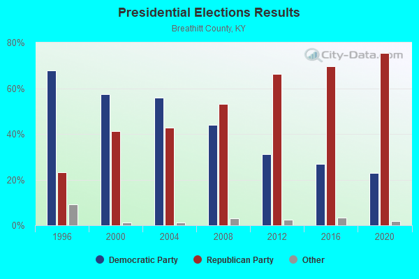
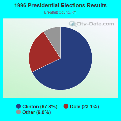
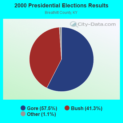
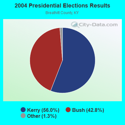
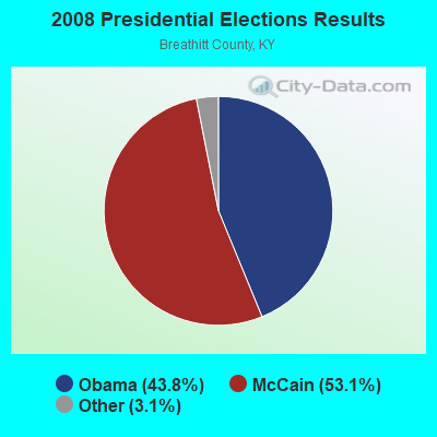
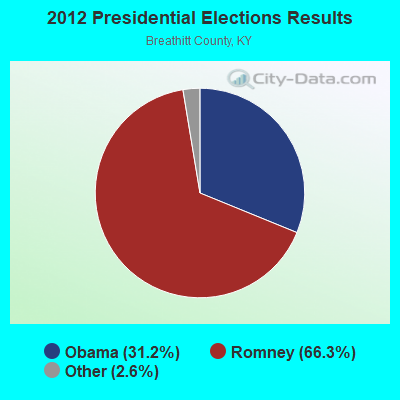
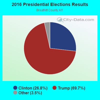
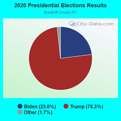
Graphs represent county-level data. Detailed 2008 Election Results
Religion statistics for Hardshell, KY (based on Breathitt County data)
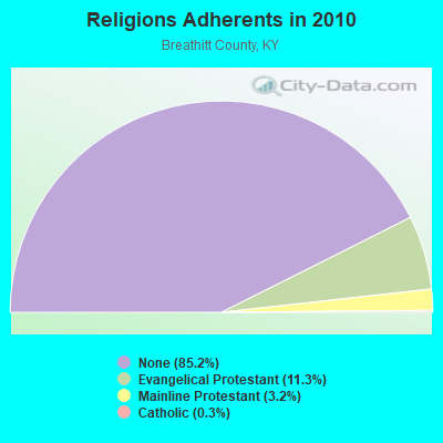
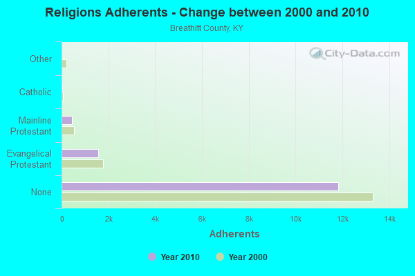
| Religion | Adherents | Congregations |
|---|---|---|
| Evangelical Protestant | 1,563 | 20 |
| Mainline Protestant | 448 | 6 |
| Catholic | 35 | 1 |
| Other | 3 | 1 |
| None | 11,829 | - |
Food Environment Statistics:
| Breathitt County: | 2.55 / 10,000 pop. |
| State: | 2.19 / 10,000 pop. |
| Breathitt County: | 5.10 / 10,000 pop. |
| State: | 4.36 / 10,000 pop. |
| Breathitt County: | 3.19 / 10,000 pop. |
| State: | 5.74 / 10,000 pop. |
| Breathitt County: | 14.2% |
| State: | 11.0% |
| Here: | 35.5% |
| Kentucky: | 30.0% |
| Breathitt County: | 18.6% |
| Kentucky: | 15.9% |
Strongest AM radio stations in Hardshell:
- WEKG (810 AM; daytime; 5 kW; JACKSON, KY; Owner: INTERMOUNTAIN B/CING CO., INC.)
- WMTC (730 AM; 5 kW; VANCLEVE, KY; Owner: THE KENTUCKY MOUNTAIN HOLINESS ASSN.)
- WKIC (1390 AM; 5 kW; HAZARD, KY)
- WKYH (600 AM; 5 kW; PAINTSVILLE, KY; Owner: HIGHLANDS BROADCASTING CORPORATION)
- WPRT (960 AM; 5 kW; PRESTONSBURG, KY; Owner: EAST KENTUCKY RADIO NETWORK, INC.)
- WKVL (850 AM; daytime; 50 kW; KNOXVILLE, TN; Owner: HORNE RADIO, LLC)
- WDOC (1310 AM; 5 kW; PRESTONSBURG, KY)
- WQXY (1560 AM; daytime; 1 kW; HAZARD, KY; Owner: BLACK GOLD BROADCASTING)
- WLSI (900 AM; 5 kW; PIKEVILLE, KY; Owner: EAST KENTUCKY BROADCASTING CORPORATION)
- WTCW (920 AM; 4 kW; WHITESBURG, KY; Owner: T.C.W. BROADCASTING , INC.)
- WTVN (610 AM; 50 kW; COLUMBUS, OH; Owner: CITICASTERS LICENSES, L.P.)
- WHAS (840 AM; 50 kW; LOUISVILLE, KY; Owner: CLEAR CHANNEL BROADCASTING LICENSES, INC.)
- WLW (700 AM; 50 kW; CINCINNATI, OH; Owner: JACOR BROADCASTING CORPORATION)
Strongest FM radio stations in Hardshell:
- WZQQ (97.9 FM; HYDEN, KY; Owner: LESLIE COUNTY BROADCASTING, INC.)
- WJSN-FM (106.5 FM; JACKSON, KY; Owner: INTERMOUNTAIN BROADCASTING CO.)
- WJMD (104.7 FM; HAZARD, KY; Owner: HAZARD BROADCASTING SERVICES)
- WSGS (101.1 FM; HAZARD, KY; Owner: MOUNTAIN BROADCASTING SERVICE, INC.)
- WEKH (90.9 FM; HAZARD, KY; Owner: EASTERN KENTUCKY UNIVERSITY)
- WSEH (102.7 FM; CUMBERLAND, KY; Owner: CUMBERLAND CITY BROADCASTING, INC.)
- WKCB-FM (107.1 FM; HINDMAN, KY; Owner: HINDMAN BROADCASTING CORPORATION)
- WIFX-FM (94.3 FM; JENKINS, KY; Owner: LETCHER COUNTY BROADCASTING, INC)
- WXKQ-FM (103.9 FM; WHITESBURG, KY; Owner: T.C.W. BROADCASTING , INC.)
- WMMT (88.7 FM; WHITESBURG, KY; Owner: APPALSHOP, INCORPORATED)
- WAXM (93.5 FM; BIG STONE GAP, VA; Owner: VALLEY BROADCASTING, INC.)
- WQHY (95.5 FM; PRESTONSBURG, KY; Owner: WDOC, INC.)
- WDXC (102.3 FM; POUND, VA; Owner: WDXC RADIO, INC.)
- WWJD (91.7 FM; PIPPA PASSES, KY; Owner: ALICE LLOYD COLLEGE)
- WMTC-FM (99.9 FM; VANCLEVE, KY; Owner: KENTUCKY MOUNTAIN HOLINESS ASSOC.)
- WLJC (102.1 FM; BEATTYVILLE, KY; Owner: HOUR OF HARVEST, INCORPORATED)
- W223AA (92.5 FM; BIG STONE GAP, VA; Owner: VALLEY BROADCASTING, INC.)
- WTUK (105.1 FM; HARLAN, KY; Owner: EASTERN BROADCASTING COMPANY)
- WPKE-FM (103.1 FM; COAL RUN, KY; Owner: EAST KENTUCKY BROADCASTING CORP.)
- WKLW-FM (94.7 FM; PAINTSVILLE, KY; Owner: B & G BROADCASTING, INC.)
TV broadcast stations around Hardshell:
- W26BK (Channel 26; TALBERT, KY; Owner: MS COMMUNICATIONS, LLC)
- W16BI (Channel 16; TALBERT, KY; Owner: MS COMMUNICATIONS, LLC)
- W64CM (Channel 64; TALBERT, KY; Owner: MS COMMUNICATIONS, LLC)
- W66DA (Channel 66; TALBERT, KY; Owner: MS COMMUNICATIONS, LLC)
- WYMT-TV (Channel 57; HAZARD, KY; Owner: WYMT LICENSEE CORP.)
- W24BT (Channel 24; TALBERT, KY; Owner: MS COMMUNICATIONS, LLC)
- W54CI (Channel 54; TALBERT, KY; Owner: MS COMMUNICATIONS, LLC)
- WKHA (Channel 35; HAZARD, KY; Owner: KENTUCKY AUTHORITY FOR EDUCATIONAL TV)
- WLJC-TV (Channel 65; BEATTYVILLE, KY; Owner: HOUR OF HARVEST, INC.)
- WUPX-TV (Channel 67; MOREHEAD, KY; Owner: PAXSON LEXINGTON LICENSE, INC.)
- W31BU (Channel 31; TALBERT, KY; Owner: MS COMMUNICATIONS, LLC)
- W53BQ (Channel 53; TALBERT, KY; Owner: MS COMMUNICATIONS, LLC)
- W69ED (Channel 69; TALBERT, KY; Owner: MS COMMUNICATIONS, LLC)

Hardshell fatal accident list:
Apr 15, 1992 04:15 PM, 476, Vehicles: 1, Persons: 2, Fatalities: 1

- 62.9%Electricity
- 14.2%Coal or coke
- 12.9%Bottled, tank, or LP gas
- 7.2%Fuel oil, kerosene, etc.
- 2.0%Wood
- 0.8%Utility gas

- 50.0%Electricity
- 19.2%Bottled, tank, or LP gas
- 16.9%Wood
- 13.8%Fuel oil, kerosene, etc.
Hardshell compared to Kentucky state average:
- Median household income below state average.
- Median house value significantly below state average.
- Unemployed percentage below state average.
- Black race population percentage significantly below state average.
- Hispanic race population percentage below state average.
- Median age below state average.
- Foreign-born population percentage significantly below state average.
- Renting percentage below state average.
- Length of stay since moving in significantly above state average.
- Number of rooms per house significantly below state average.
- House age significantly below state average.
- Percentage of population with a bachelor's degree or higher significantly below state average.