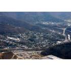
Hazard, Kentucky
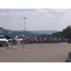
Hazard: raiseing money for the children in Hazard
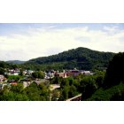
Hazard: On a hill in Hazard
Hazard: ROUTE 15 GRAPEVINE
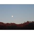
Hazard: God's Blessing in Hazard
Hazard: hazard,ky.
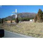
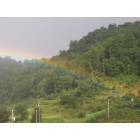
Hazard: Broken Cross on way to Florida

Hazard: Trucks move it all in Virginia
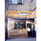
Hazard: Hazard Sandwich Shop

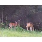
Hazard: Road to Buckhorn State Park
Hazard: Downtown Hazard
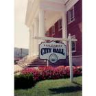
Hazard: Hazard City Hall
- add
your
Submit your own pictures of this city and show them to the world
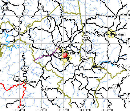
- OSM Map
- General Map
- Google Map
- MSN Map
Population change since 2000: +4.0%
 |
| Males: 2,478 | |
| Females: 2,521 |
| Median resident age: | 40.6 years |
| Kentucky median age: | 39.4 years |
Zip codes: 41701.
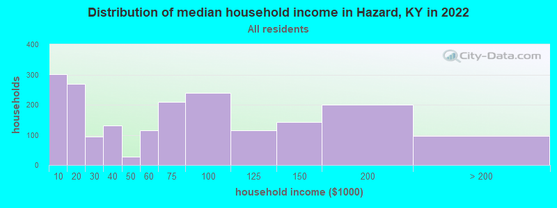
| Hazard: | $64,925 |
| KY: | $59,341 |
Estimated per capita income in 2022: $44,143 (it was $14,782 in 2000)
Hazard city income, earnings, and wages data
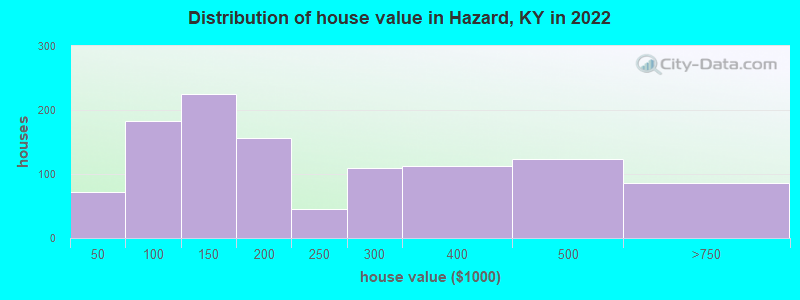
Estimated median house or condo value in 2022: $162,918 (it was $65,600 in 2000)
| Hazard: | $162,918 |
| KY: | $196,300 |
Mean prices in 2022: all housing units: $299,118; detached houses: $315,718; mobile homes: $23,366
Median gross rent in 2022: $705.
(28.2% for White Non-Hispanic residents, 77.0% for Black residents, 100.0% for American Indian residents, 45.8% for two or more races residents)
Detailed information about poverty and poor residents in Hazard, KY
Compare current foreclosures in Hazard, KY:
| Photo | Address | Area | Beds / Baths | Price | Details |
|---|---|---|---|---|---|

|
#1
Laurel St
Hazard, KY 41701
|
1,898 sq. feet
|
2 baths 3 beds |
show details | |

|
#2
Pecan St
Hazard, KY 41701
|
2,411 sq. feet
|
2 baths 3 beds |
show details | |

|
#3
Highway 721
Hazard, KY 41701
|
984 sq. feet
|
1 baths 2 beds |
show details | |

|
#4
Begley Ct # 3
Hazard, KY 41701
|
1,792 sq. feet
|
2 baths 3 beds |
show details | |

|
#5
Whitaker Fork Rd
Hazard, KY 41701
|
1,080 sq. feet
|
2 baths 3 beds |
show details | |

|
#6
Orchard Heights Rd
Hazard, KY 41701
|
- sq. feet
|
1 baths 3 beds |
show details | |

|
#7
Moore St
Hazard, KY 41701
|
- sq. feet
|
1 baths 4 beds |
show details | |

|
#8
Railroad Ct
Hazard, KY 41701
|
- sq. feet
|
1 baths 2 beds |
show details | |

|
#9
Gorman Hollow Rd
Hazard, KY 41701
|
- sq. feet
|
- baths - beds |
show details | |

|
#10
N Main St
Hazard, KY 41701
|
- sq. feet
|
- baths - beds |
show details |
| Photo | Address | Area | Beds / Baths | Price | Details |
|---|---|---|---|---|---|

|
#11
Parkview Dr
Hazard, KY 41701
|
- sq. feet
|
- baths - beds |
show details | |

|
#12
28 Hwy
Hazard, KY 41701
|
- sq. feet
|
- baths - beds |
show details | |

|
#13
Roy Campbell Dr Apt 101
Hazard, KY 41701
|
- sq. feet
|
- baths - beds |
show details | |

|
#14
Jacks Br
Hazard, KY 41701
|
- sq. feet
|
- baths - beds |
show details | |

|
#15
Elk Fork Rd
Hazard, KY 41701
|
- sq. feet
|
- baths - beds |
show details | |

|
#16
Walton Mountain Ln
Hazard, KY 41701
|
- sq. feet
|
- baths - beds |
show details | |

|
#17
Railroad Ct
Hazard, KY 41701
|
- sq. feet
|
- baths - beds |
show details | |

|
#18
Lotts Creek Rd
Hazard, KY 41701
|
- sq. feet
|
- baths - beds |
show details | |

|
#19
Hudson Drive
Hazard, KY 41701
|
- sq. feet
|
- baths - beds |
show details | |

|
#20
Twin Rocks Ln
Hazard, KY 41701
|
- sq. feet
|
- baths - beds |
show details |
| Photo | Address | Area | Beds / Baths | Price | Details |
|---|---|---|---|---|---|

|
#21
N Ky Highway 15
Hazard, KY 41701
|
- sq. feet
|
- baths - beds |
show details | |

|
#22
N Ky Highway 15
Hazard, KY 41701
|
1,200 sq. feet
|
- baths - beds |
show details | |

|
#23
Gorman Hollow Rd
Hazard, KY 41701
|
- sq. feet
|
- baths - beds |
show details | |

|
#24
Cornett Hill Dr
Hazard, KY 41701
|
- sq. feet
|
- baths - beds |
show details | |

|
#25
Elma Ln
Hazard, KY 41701
|
- sq. feet
|
- baths - beds |
show details | |

|
#26
Hull School Rd
Hazard, KY 41701
|
1,120 sq. feet
|
- baths - beds |
show details | |

|
#27
Desiree Ln
Hazard, KY 41701
|
- sq. feet
|
- baths - beds |
show details | |

|
#28
Elk Fork Rd
Hazard, KY 41701
|
500 sq. feet
|
- baths - beds |
show details | |

|
#29
Shady Pine Ln
Hazard, KY 41701
|
- sq. feet
|
- baths - beds |
show details | |

|
#30
Jacks Branch Rd
Hazard, KY 41701
|
- sq. feet
|
- baths - beds |
show details |
| Photo | Address | Area | Beds / Baths | Price | Details |
|---|---|---|---|---|---|

|
#31
Gorman Ridge Rd
Hazard, KY 41701
|
- sq. feet
|
- baths - beds |
show details | |

|
#32
Broadway St
Hazard, KY 41701
|
1,024 sq. feet
|
- baths - beds |
show details | |

|
#33
Gorman Hollow Rd Apt 211
Hazard, KY 41701
|
- sq. feet
|
- baths - beds |
show details | |

|
#34
Cherokee Hills Rd Apt 408
Hazard, KY 41701
|
- sq. feet
|
- baths - beds |
show details | |

|
#35
Lost Creek Rd
Hazard, KY 41701
|
- sq. feet
|
- baths - beds |
show details | |

|
#36
Raccoon Creek Rd
Hazard, KY 41701
|
- sq. feet
|
- baths - beds |
show details | |

|
#37
Highway 721
Hazard, KY 41701
|
- sq. feet
|
- baths - beds |
show details | |

|
#38
Whitaker Fork Rd
Hazard, KY 41701
|
- sq. feet
|
- baths - beds |
show details | |

|
#39
Upper Second Creek Rd
Hazard, KY 41701
|
- sq. feet
|
- baths - beds |
show details | |

|
Check over 1 million property listings on Foreclosure.com!
|
browse all offers | |||


- 4,50986.6%White alone
- 2885.5%Two or more races
- 1673.2%Asian alone
- 1502.9%Hispanic
- 731.4%Black alone
- 340.7%American Indian alone

Races in Hazard detailed stats: ancestries, foreign born residents, place of birth
According to our research of Kentucky and other state lists, there were 32 registered sex offenders living in Hazard, Kentucky as of May 22, 2024.
The ratio of all residents to sex offenders in Hazard is 169 to 1.
Type |
2009 |
2010 |
2011 |
2012 |
2013 |
2014 |
2015 |
2016 |
2017 |
2018 |
2019 |
2020 |
2021 |
2022 |
|---|---|---|---|---|---|---|---|---|---|---|---|---|---|---|
| Murders (per 100,000) | 0 (0.0) | 0 (0.0) | 0 (0.0) | 0 (0.0) | 4 (73.3) | 0 (0.0) | 0 (0.0) | 0 (0.0) | 0 (0.0) | 0 (0.0) | 1 (20.3) | 0 (0.0) | 0 (0.0) | 0 (0.0) |
| Rapes (per 100,000) | 4 (83.5) | 3 (67.3) | 4 (89.1) | 2 (44.7) | 3 (55.0) | 1 (18.5) | 6 (113.0) | 3 (56.5) | 1 (19.0) | 4 (79.4) | 3 (60.8) | 2 (41.7) | 2 (42.4) | 6 (119.7) |
| Robberies (per 100,000) | 5 (104.4) | 4 (89.8) | 7 (156.0) | 7 (156.5) | 7 (128.3) | 5 (92.3) | 11 (207.2) | 2 (37.7) | 5 (94.9) | 5 (99.3) | 1 (20.3) | 3 (62.6) | 1 (21.2) | 0 (0.0) |
| Assaults (per 100,000) | 6 (125.3) | 8 (179.5) | 8 (178.3) | 10 (223.5) | 17 (311.6) | 7 (129.3) | 4 (75.4) | 1 (18.8) | 7 (132.9) | 5 (99.3) | 9 (182.3) | 6 (125.1) | 3 (63.5) | 3 (59.9) |
| Burglaries (per 100,000) | 37 (772.6) | 93 (2,087) | 45 (1,003) | 59 (1,319) | 46 (843.3) | 42 (775.6) | 45 (847.8) | 24 (452.0) | 19 (360.7) | 18 (357.5) | 20 (405.0) | 17 (354.5) | 11 (233.0) | 7 (139.7) |
| Thefts (per 100,000) | 218 (4,552) | 213 (4,780) | 317 (7,065) | 251 (5,610) | 206 (3,776) | 292 (5,392) | 236 (4,446) | 241 (4,539) | 172 (3,265) | 112 (2,224) | 110 (2,228) | 96 (2,002) | 53 (1,123) | 24 (478.9) |
| Auto thefts (per 100,000) | 11 (229.7) | 12 (269.3) | 11 (245.2) | 4 (89.4) | 12 (220.0) | 3 (55.4) | 9 (169.6) | 8 (150.7) | 11 (208.8) | 16 (317.8) | 14 (283.5) | 18 (375.3) | 17 (360.1) | 15 (299.3) |
| Arson (per 100,000) | 4 (83.5) | 0 (0.0) | 1 (22.3) | 2 (44.7) | 2 (36.7) | 1 (18.5) | 2 (37.7) | 0 (0.0) | 1 (19.0) | 2 (39.7) | 3 (60.8) | 1 (20.9) | 1 (21.2) | 0 (0.0) |
| City-Data.com crime index | 377.7 | 475.5 | 526.2 | 451.3 | 519.2 | 342.8 | 418.4 | 285.5 | 242.8 | 252.6 | 271.8 | 212.1 | 143.0 | 160.6 |
The City-Data.com crime index weighs serious crimes and violent crimes more heavily. Higher means more crime, U.S. average is 246.1. It adjusts for the number of visitors and daily workers commuting into cities.
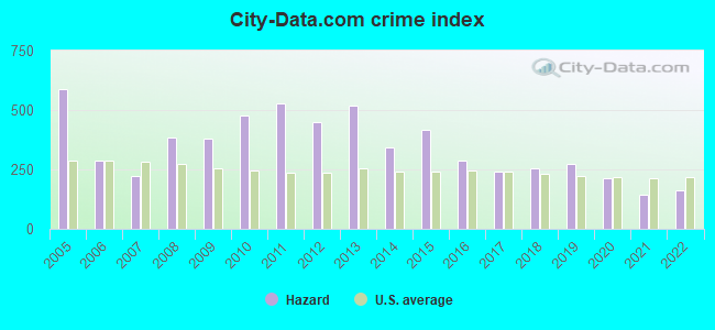
Crime rate in Hazard detailed stats: murders, rapes, robberies, assaults, burglaries, thefts, arson
Full-time law enforcement employees in 2021, including police officers: 26 (18 officers - 17 male; 1 female).
| Officers per 1,000 residents here: | 3.81 |
| Kentucky average: | 1.89 |
 Recent articles from our blog. Our writers, many of them Ph.D. graduates or candidates, create easy-to-read articles on a wide variety of topics.


Latest news from Hazard, KY collected exclusively by city-data.com from local newspapers, TV, and radio stations
Ancestries: American (33.8%), English (19.8%), Irish (10.3%), Scotch-Irish (6.7%), Scottish (5.6%), Italian (3.2%).
Current Local Time: EST time zone
Incorporated on 04/30/1884
Land area: 7.02 square miles.
Population density: 712 people per square mile (low).
154 residents are foreign born (2.6% Asia, 0.3% Africa).
| This city: | 3.0% |
| Kentucky: | 4.1% |
Median real estate property taxes paid for housing units with mortgages in 2022: $1,538 (0.8%)
Median real estate property taxes paid for housing units with no mortgage in 2022: $941 (0.7%)
Nearest city with pop. 50,000+: Johnson City, TN  (78.2 miles , pop. 55,469).
Nearest city with pop. 200,000+: Fayette, KY (89.1 miles , pop. 260,512).
Nearest city with pop. 1,000,000+: Chicago, IL (397.1 miles , pop. 2,896,016).
Nearest cities:
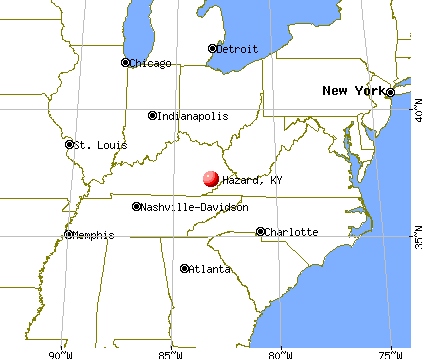
), ), ), ), ), ), )Latitude: 37.26 N, Longitude: 83.19 W
Daytime population change due to commuting: +6,151 (+118.2%)
Workers who live and work in this city: 1,344 (79.7%)
Area code: 606

Hazard, Kentucky accommodation & food services, waste management - Economy and Business Data
Single-family new house construction building permits:
- 2016: 6 buildings, average cost: $106,600
- 2015: 5 buildings, average cost: $106,600
- 2014: 5 buildings, average cost: $106,600
- 2013: 6 buildings, average cost: $132,500
- 2012: 9 buildings, average cost: $97,500
- 2011: 8 buildings, average cost: $97,500
- 2010: 9 buildings, average cost: $87,500
- 2009: 8 buildings, average cost: $85,500
- 2008: 7 buildings, average cost: $125,300
- 2007: 10 buildings, average cost: $125,300
- 2006: 12 buildings, average cost: $125,300
- 2005: 16 buildings, average cost: $76,500
- 2004: 14 buildings, average cost: $76,500
- 2003: 13 buildings, average cost: $76,500
- 2002: 12 buildings, average cost: $89,900
- 2001: 11 buildings, average cost: $89,900
- 2000: 10 buildings, average cost: $101,300
- 1999: 9 buildings, average cost: $86,000
- 1998: 6 buildings, average cost: $113,100
- 1997: 8 buildings, average cost: $105,600


| Here: | 5.4% |
| Kentucky: | 3.8% |


- Health care (18.0%)
- Educational services (7.7%)
- Finance & insurance (6.1%)
- Public administration (5.2%)
- Mining, quarrying, oil & gas extraction (4.7%)
- Repair & maintenance (4.6%)
- Construction (3.8%)

- Health care (11.4%)
- Mining, quarrying, oil & gas extraction (9.4%)
- Repair & maintenance (9.3%)
- Public administration (8.2%)
- Construction (7.6%)
- Truck transportation (4.4%)
- Building material & garden equipment & supplies dealers (4.4%)

- Health care (24.5%)
- Educational services (14.4%)
- Finance & insurance (10.0%)
- Accommodation & food services (6.7%)
- Department & other general merchandise stores (4.8%)
- Apparel (4.4%)
- Personal & laundry services (4.2%)

- Other sales and related occupations, including supervisors (8.6%)
- Electrical equipment mechanics and other installation, maintenance, and repair workers, including supervisors (4.6%)
- Driver/sales workers and truck drivers (4.2%)
- Other office and administrative support workers, including supervisors (3.9%)
- Health technologists and technicians (3.8%)
- Information and record clerks, except customer service representatives (3.7%)
- Physicians and surgeons (3.2%)

- Other sales and related occupations, including supervisors (10.0%)
- Electrical equipment mechanics and other installation, maintenance, and repair workers, including supervisors (9.3%)
- Driver/sales workers and truck drivers (8.5%)
- Vehicle and mobile equipment mechanics, installers, and repairers (6.0%)
- Physicians and surgeons (4.2%)
- Carpenters (4.0%)
- Engineers (3.6%)

- Other sales and related occupations, including supervisors (7.1%)
- Other office and administrative support workers, including supervisors (7.1%)
- Registered nurses (6.3%)
- Health technologists and technicians (5.5%)
- Preschool, kindergarten, elementary, and middle school teachers (4.5%)
- Information and record clerks, except customer service representatives (4.4%)
- Textile, apparel, and furnishings workers (4.4%)
Average climate in Hazard, Kentucky
Based on data reported by over 4,000 weather stations


|
|

(lower is better)

Air Quality Index (AQI) level in 2022 was 81.6. This is about average.
| City: | 81.6 |
| U.S.: | 72.6 |

Ozone [ppb] level in 2022 was 24.9. This is better than average. Closest monitor was 1.2 miles away from the city center.
| City: | 24.9 |
| U.S.: | 33.3 |

Particulate Matter (PM2.5) [µg/m3] level in 2022 was 9.26. This is about average. Closest monitor was 2.1 miles away from the city center.
| City: | 9.26 |
| U.S.: | 8.11 |
Tornado activity:
Hazard-area historical tornado activity is significantly below Kentucky state average. It is 62% smaller than the overall U.S. average.
On 5/18/1995, a category F2 (max. wind speeds 113-157 mph) tornado 13.4 miles away from the Hazard city center caused between $50,000 and $500,000 in damages.
On 6/9/1961, a category F3 (max. wind speeds 158-206 mph) tornado 42.7 miles away from the city center killed one person and injured 63 people and caused between $500,000 and $5,000,000 in damages.
Earthquake activity:
Hazard-area historical earthquake activity is significantly above Kentucky state average. It is 43% greater than the overall U.S. average.On 7/27/1980 at 18:52:21, a magnitude 5.2 (5.1 MB, 4.7 MS, 5.0 UK, 5.2 UK, Class: Moderate, Intensity: VI - VII) earthquake occurred 77.4 miles away from Hazard center
On 8/9/2020 at 12:07:37, a magnitude 5.1 (5.1 MW, Depth: 4.7 mi) earthquake occurred 128.1 miles away from the city center
On 8/23/2011 at 17:51:04, a magnitude 5.8 (5.8 MW, Depth: 3.7 mi) earthquake occurred 291.7 miles away from Hazard center
On 9/7/1988 at 02:28:09, a magnitude 4.6 (4.5 MB, 4.6 LG, Class: Light, Intensity: IV - V) earthquake occurred 71.9 miles away from the city center
On 11/30/1973 at 07:48:41, a magnitude 4.7 (4.7 MB, 4.6 ML) earthquake occurred 109.4 miles away from Hazard center
On 11/10/2012 at 17:08:14, a magnitude 4.2 (4.2 MW, Depth: 10.6 mi) earthquake occurred 11.2 miles away from Hazard center
Magnitude types: regional Lg-wave magnitude (LG), body-wave magnitude (MB), local magnitude (ML), surface-wave magnitude (MS), moment magnitude (MW)
Natural disasters:
The number of natural disasters in Perry County (34) is a lot greater than the US average (15).Major Disasters (Presidential) Declared: 28
Emergencies Declared: 3
Causes of natural disasters: Floods: 25, Storms: 25, Tornadoes: 12, Mudslides: 10, Landslides: 6, Winter Storms: 5, Winds: 3, Snowstorms: 2, Blizzard: 1, Freeze: 1, Hurricane: 1, Snow: 1, Snowfall: 1, Other: 1 (Note: some incidents may be assigned to more than one category).
Main business address for: Kentucky First Federal Bancorp (SAVINGS INSTITUTION, FEDERALLY CHARTERED).
Hospitals and medical centers in Hazard:
- HAZARD ARH REGIONAL MEDICAL CENTER (Voluntary non-profit - Private, provides emergency services, 100 MEDICAL CENTER DRIVE)
- MOUNTAIN COMMUNITY HOSPICE (3115 NORTH MAIN STREET, SUITE 101)
- HAZARD HEALTH AND REHABILITATION CENTER (390 PARK AVENUE)
- FMC - HAZARD (516 VILLAGE LANE)
- HAZARD ARH HHA (100 AIRPORT GARDENS ROAD)
Airports and heliports located in Hazard:
- Wendell H Ford Airport (CPF) (Runways: 2, Air Taxi Ops: 1,320, Itinerant Ops: 4,200, Local Ops: 3,850, Military Ops: 800)
- Hazard Arh Heliport (9JY9)
College/University in Hazard:
Other colleges/universities with over 2000 students near Hazard:
- Southeast Kentucky Community and Technical College (about 23 miles; Cumberland, KY; Full-time enrollment: 2,196)
- Big Sandy Community and Technical College (about 38 miles; Prestonsburg, KY; FT enrollment: 2,660)
- Lincoln Memorial University (about 54 miles; Harrogate, TN; FT enrollment: 3,706)
- University of the Cumberlands (about 65 miles; Williamsburg, KY; FT enrollment: 3,585)
- Morehead State University (about 66 miles; Morehead, KY; FT enrollment: 7,523)
- Northeast State Community College (about 69 miles; Blountville, TN; FT enrollment: 4,480)
- Eastern Kentucky University (about 70 miles; Richmond, KY; FT enrollment: 13,525)
Public high schools in Hazard:
- PERRY COUNTY CENTRAL HIGH SCHOOL (Students: 989, Location: 305 PARK AVE, Grades: 9-12)
- HAZARD HIGH SCHOOL (Students: 316, Location: 157 BULLDOG LN, Grades: 9-12)
- CORDIA SCHOOL (Students: 123, Location: 6050 LOTTS CREEK ROAD, Grades: PK-12)
Public elementary/middle schools in Hazard:
- ROY G. EVERSOLE ELEMENTARY SCHOOL (Students: 335, Location: 601 BROADWAY, Grades: PK-4)
- HAZARD MIDDLE SCHOOL (Location: 325 SCHOOL STREET, Grades: 5-8)
- EAST PERRY COUNTY ELEMENTARY SCHOOL (Location: 301 PERRY CIRCLE RD, Grades: PK-8)
User-submitted facts and corrections:
- I would like to post our web address for our Senior Center. www.hpscc.org The name is the Hazard Perry County Senior Center
Points of interest:
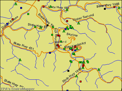
Notable locations in Hazard: Hazard City Hall (A), Kentucky Division of Forestry Kentucky River District (B), Hazard Fire Department (C), Hazard Fire Department Station 2 (D), Perry County Ambulance Authority (E). Display/hide their locations on the map
Main business address in Hazard: Kentucky First Federal Bancorp (A). Display/hide its location on the map
Churches in Hazard include: Town Mountain Baptist Church (A), Lothair Church (B). Display/hide their locations on the map
Streams, rivers, and creeks: Davidson Branch (A), Walker Branch (B), Upper Second Creek (C), Messer Branch (D), Garman Branch (E). Display/hide their locations on the map
Parks in Hazard include: Perry County Park (1), Neace Gorman Park (2). Display/hide their locations on the map
Hotels: Big EZ Roadhouse (200 Dawahare Drive), Chaney Enterprises (306 Morton Boulevard), Combs Motel (1616 North Main Street), Days Inn (359 Morton Boulevard), Hampton Inn & Suites Hazard- KY (70 Morton Boulevard), Super 8 Motel (125 Village Lane), Holiday Inn (200 Dawahare Dr), Daniel Boone Motor Inn (90 Boone Ridge Road), Super 8 Hazard KY (125 Village Lane).
Courts: Kentucky Commonwealth - Court Of Justice-Circuit Judge (Court House), Perry Co Fiscal Court Maintenance Garage (2715 Christopher Road), Kentucky Commonwealth - Administative Offices Of The Courts- Court Designated Wo (545 Main Street), Perry County Fiscal Court (497 Perry Park Road).
Birthplace of: Jon Olinger - 2005 NFL player (Carolina Panthers, born: Aug 24, 1980), Rebecca Gayheart - (born 1972), actress, Cora Combs - Female professional wrestler, Cindy Jackson - Vegetarian, Glen Combs - Basketball player, Mary Lou Turner - Country singer.
Drinking water stations with addresses in Hazard and their reported violations in the past:
HAZARD WATER DEPARTMENT (Population served: 26,730, Surface water):Past health violations:Past monitoring violations:
- MCL, Average - Between JUL-2013 and SEP-2013, Contaminant: Total Haloacetic Acids (HAA5). Follow-up actions: St Public Notif requested (NOV-06-2013), St Formal NOV issued (NOV-06-2013), St Public Notif received (NOV-27-2013)
- MCL, Monthly (TCR) - In JUL-2007, Contaminant: Coliform. Follow-up actions: St Public Notif requested (SEP-24-2007), St Formal NOV issued (SEP-24-2007), St Compliance achieved (OCT-10-2007), St Public Notif received (OCT-22-2007)
- Monthly Turbidity Exceed (Enhanced SWTR) - In JAN-2010, Contaminant: IESWTR. Follow-up actions: St Public Notif requested (MAR-23-2010), St Formal NOV issued (MAR-23-2010), St Compliance achieved (MAY-19-2010), St Public Notif received (AUG-16-2011)
- One minor monitoring violation
- One regular monitoring violation
| This city: | 2.3 people |
| Kentucky: | 2.5 people |
| This city: | 60.8% |
| Whole state: | 66.9% |
| This city: | 6.9% |
| Whole state: | 6.4% |
Likely homosexual households (counted as self-reported same-sex unmarried-partner households)
- Lesbian couples: 0.3% of all households
- Gay men: 0.5% of all households
13 people in emergency and transitional shelters (with sleeping facilities) for people experiencing homelessness in 2010
People in group quarters in Hazard in 2000:
- 198 people in nursing homes
- 74 people in mental (psychiatric) hospitals or wards
- 47 people in local jails and other confinement facilities (including police lockups)
- 17 people in other noninstitutional group quarters
Banks with branches in Hazard (2011 data):
- Peoples Bank & Trust Company of Hazard: Airport Gardens Branch, East Main Street Branch, Daniel Boone Branch, Wal-Mart Branch, Peoples Express Bank & Merchant Cent, Peoples Bank & Trust Company Of Haza. Info updated 2009/06/25: Bank assets: $287.1 mil, Deposits: $250.1 mil, local headquarters, positive income, Commercial Lending Specialization, 7 total offices, Holding Company: Hazard Bancorp
- Community Trust Bank, Inc.: Hazard Black Gold Branch, Hazard Main Street Branch, Hazard Village Branch, Hazard Airport Gardens Branch. Info updated 2011/03/25: Bank assets: $3,573.0 mil, Deposits: $2,890.4 mil, headquarters in Pikeville, KY, positive income, Commercial Lending Specialization, 80 total offices, Holding Company: Community Trust Bancorp, Inc.
- 1st Trust Bank, Inc.: at 24 Commerce Drive, branch established on 2004/12/13; Black Gold Branch at 106 Black Gold Court, branch established on 2006/08/01. Info updated 2006/11/03: Bank assets: $137.0 mil, Deposits: $124.6 mil, local headquarters, positive income, Commercial Lending Specialization, 2 total offices
- Whitaker Bank: Mountain Credit Branch at Highway 15 South, branch established on 2001/07/16; Hazard Branch at Morton Drive, branch established on 2005/02/23. Info updated 2008/07/07: Bank assets: $1,497.1 mil, Deposits: $1,225.4 mil, headquarters in Lexington, KY, positive income, Commercial Lending Specialization, 39 total offices, Holding Company: Whitaker Bank Corporation Of Kentucky
- First Federal Savings and Loan Association: First Federal Savings And Loan Assoc at Main & Lovern Streets, branch established on 1960/07/26. Info updated 2011/07/21: Bank assets: $99.4 mil, Deposits: $69.3 mil, local headquarters, positive income, Mortgage Lending Specialization, 1 total offices
For population 15 years and over in Hazard:

- Never married: 31.8%
- Now married: 42.5%
- Separated: 6.8%
- Widowed: 5.6%
- Divorced: 13.2%
For population 25 years and over in Hazard:
- High school or higher: 85.3%
- Bachelor's degree or higher: 23.9%
- Graduate or professional degree: 15.3%
- Unemployed: 7.5%
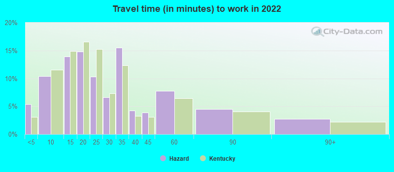
- Mean travel time to work (commute): 15.2 minutes


| Here: | 13.4 |
| Kentucky average: | 11.7 |
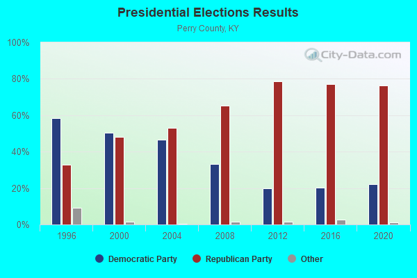
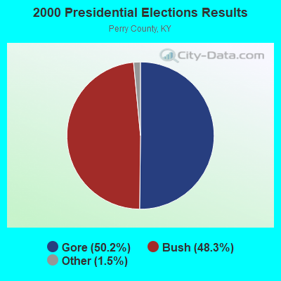
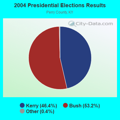
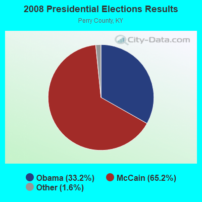
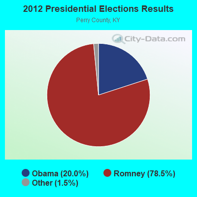
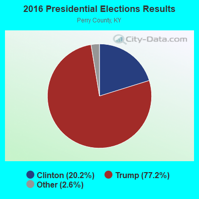
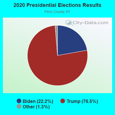
Graphs represent county-level data. Detailed 2008 Election Results
Religion statistics for Hazard, KY (based on Perry County data)
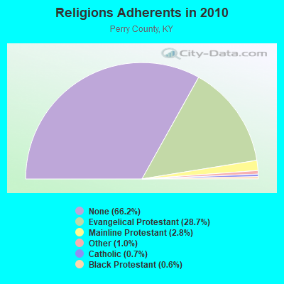
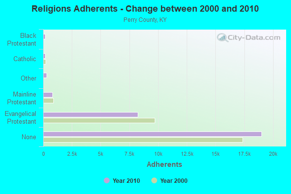
| Religion | Adherents | Congregations |
|---|---|---|
| Evangelical Protestant | 8,245 | 61 |
| Mainline Protestant | 791 | 10 |
| Other | 301 | 1 |
| Catholic | 188 | 1 |
| Black Protestant | 180 | 1 |
| None | 19,007 | - |
Food Environment Statistics:
| Perry County: | 3.09 / 10,000 pop. |
| Kentucky: | 2.19 / 10,000 pop. |
| This county: | 1.03 / 10,000 pop. |
| State: | 0.74 / 10,000 pop. |
| This county: | 6.86 / 10,000 pop. |
| Kentucky: | 4.36 / 10,000 pop. |
| Perry County: | 5.14 / 10,000 pop. |
| Kentucky: | 5.74 / 10,000 pop. |
| Here: | 10.9% |
| State: | 11.0% |
| Here: | 34.7% |
| Kentucky: | 30.0% |
| This county: | 23.0% |
| Kentucky: | 15.9% |
Health and Nutrition:
| Here: | 53.9% |
| Kentucky: | 49.9% |
| This city: | 47.1% |
| Kentucky: | 47.0% |
| Here: | 28.4 |
| Kentucky: | 28.6 |
| Here: | 16.6% |
| Kentucky: | 21.0% |
| Here: | 15.3% |
| Kentucky: | 10.1% |
| Hazard: | 6.7 |
| State: | 6.8 |
| Hazard: | 31.1% |
| State: | 33.8% |
| This city: | 54.5% |
| Kentucky: | 56.8% |
| Hazard: | 83.9% |
| State: | 78.9% |
More about Health and Nutrition of Hazard, KY Residents
| Local government employment and payroll (March 2022) | |||||
| Function | Full-time employees | Monthly full-time payroll | Average yearly full-time wage | Part-time employees | Monthly part-time payroll |
|---|---|---|---|---|---|
| Water Supply | 23 | $57,033 | $29,756 | 0 | $0 |
| Police Protection - Officers | 19 | $71,818 | $45,359 | 0 | $0 |
| Streets and Highways | 17 | $38,739 | $27,345 | 0 | $0 |
| Firefighters | 16 | $58,973 | $44,230 | 4 | $1,027 |
| Sewerage | 11 | $31,292 | $34,137 | 0 | $0 |
| Police - Other | 10 | $37,204 | $44,645 | 0 | $0 |
| Financial Administration | 9 | $30,617 | $40,823 | 0 | $0 |
| Other Government Administration | 5 | $9,542 | $22,901 | 10 | $865 |
| Gas Supply | 4 | $25,035 | $75,105 | 0 | $0 |
| Parks and Recreation | 3 | $7,480 | $29,920 | 10 | $6,855 |
| Housing and Community Development (Local) | 2 | $8,202 | $49,212 | 0 | $0 |
| Totals for Government | 119 | $375,935 | $37,909 | 24 | $8,748 |
Hazard government finances - Expenditure in 2021 (per resident):
- Construction - Water Utilities: $5,686,000 ($1137.43)
Gas Utilities: $2,088,000 ($417.68)
Sewerage: $827,000 ($165.43)
Housing and Community Development: $417,000 ($83.42)
Parks and Recreation: $341,000 ($68.21)
- Current Operations - Water Utilities: $4,832,000 ($966.59)
Sewerage: $2,016,000 ($403.28)
Gas Utilities: $1,958,000 ($391.68)
Police Protection: $1,718,000 ($343.67)
Regular Highways: $1,428,000 ($285.66)
Central Staff Services: $1,359,000 ($271.85)
Local Fire Protection: $1,135,000 ($227.05)
Parks and Recreation: $607,000 ($121.42)
Solid Waste Management: $412,000 ($82.42)
Public Welfare - Other: $20,000 ($4.00)
- Gas Utilities - Interest on Debt: $23,000 ($4.60)
- General - Interest on Debt: $82,000 ($16.40)
- Other Capital Outlay - Central Staff Services: $598,000 ($119.62)
Regular Highways: $134,000 ($26.81)
Water Utilities: $120,000 ($24.00)
Local Fire Protection: $88,000 ($17.60)
Sewerage: $64,000 ($12.80)
Gas Utilities: $46,000 ($9.20)
Police Protection: $40,000 ($8.00)
Parks and Recreation: $32,000 ($6.40)
Solid Waste Management: $30,000 ($6.00)
- Total Salaries and Wages: $4,006,000 ($801.36)
- Water Utilities - Interest on Debt: $181,000 ($36.21)
Hazard government finances - Revenue in 2021 (per resident):
- Charges - Sewerage: $1,343,000 ($268.65)
Solid Waste Management: $595,000 ($119.02)
Other: $244,000 ($48.81)
Parks and Recreation: $118,000 ($23.60)
- Federal Intergovernmental - General Local Government Support: $469,000 ($93.82)
Highways: $240,000 ($48.01)
Housing and Community Development: $205,000 ($41.01)
Other: $95,000 ($19.00)
- Local Intergovernmental - Other: $25,000 ($5.00)
General Local Government Support: $14,000 ($2.80)
- Miscellaneous - Sale of Property: $251,000 ($50.21)
Rents: $118,000 ($23.60)
Fines and Forfeits: $69,000 ($13.80)
Donations From Private Sources: $45,000 ($9.00)
Interest Earnings: $28,000 ($5.60)
- Revenue - Water Utilities: $5,135,000 ($1027.21)
Gas Utilities: $2,170,000 ($434.09)
- State Intergovernmental - Other: $265,000 ($53.01)
Highways: $206,000 ($41.21)
General Local Government Support: $7,000 ($1.40)
- Tax - Individual Income: $3,663,000 ($732.75)
Property: $1,236,000 ($247.25)
Insurance Premiums Sales: $577,000 ($115.42)
Corporation Net Income: $471,000 ($94.22)
Public Utilities Sales: $219,000 ($43.81)
Alcoholic Beverage License: $155,000 ($31.01)
Other License: $5,000 ($1.00)
Hazard government finances - Debt in 2021 (per resident):
- Long Term Debt - Outstanding Unspecified Public Purpose: $17,564,000 ($3513.50)
Issue, Unspecified Public Purpose: $9,971,000 ($1994.60)
Beginning Outstanding - Unspecified Public Purpose: $8,928,000 ($1785.96)
Beginning Outstanding - Public Debt for Private Purpose: $4,553,000 ($910.78)
Outstanding Nonguaranteed - Industrial Revenue: $4,115,000 ($823.16)
Retired Unspecified Public Purpose: $1,336,000 ($267.25)
Retired Nonguaranteed - Public Debt for Private Purpose: $438,000 ($87.62)
Hazard government finances - Cash and Securities in 2021 (per resident):
- Other Funds - Cash and Securities: $8,149,000 ($1630.13)
- Sinking Funds - Cash and Securities: $4,115,000 ($823.16)
| Businesses in Hazard, KY | ||||
| Name | Count | Name | Count | |
|---|---|---|---|---|
| AT&T | 1 | Little Caesars Pizza | 1 | |
| Advance Auto Parts | 1 | Long John Silver's | 1 | |
| Applebee's | 1 | Lowe's | 1 | |
| Arby's | 1 | Maurices | 1 | |
| Burger King | 1 | McDonald's | 2 | |
| CVS | 1 | Nike | 4 | |
| Chevrolet | 1 | Papa John's Pizza | 1 | |
| Dairy Queen | 1 | Pizza Hut | 2 | |
| Fashion Bug | 1 | RadioShack | 1 | |
| FedEx | 3 | Rite Aid | 1 | |
| Ford | 1 | SAS Shoes | 1 | |
| GNC | 1 | Sears | 1 | |
| GameStop | 1 | Subway | 3 | |
| H&R Block | 2 | Super 8 | 1 | |
| Hardee's | 1 | Taco Bell | 1 | |
| Hilton | 1 | U-Haul | 1 | |
| JCPenney | 1 | UPS | 3 | |
| KFC | 1 | Vans | 2 | |
| Kmart | 1 | Walmart | 1 | |
| La-Z-Boy | 1 | Wendy's | 2 | |
| Lane Furniture | 1 | |||
Strongest AM radio stations in Hazard:
- WKIC (1390 AM; 5 kW; HAZARD, KY)
- WQXY (1560 AM; daytime; 1 kW; HAZARD, KY; Owner: BLACK GOLD BROADCASTING)
- WEKG (810 AM; daytime; 5 kW; JACKSON, KY; Owner: INTERMOUNTAIN B/CING CO., INC.)
- WMTC (730 AM; 5 kW; VANCLEVE, KY; Owner: THE KENTUCKY MOUNTAIN HOLINESS ASSN.)
- WTCW (920 AM; 4 kW; WHITESBURG, KY; Owner: T.C.W. BROADCASTING , INC.)
- WKVL (850 AM; daytime; 50 kW; KNOXVILLE, TN; Owner: HORNE RADIO, LLC)
- WFSR (970 AM; 5 kW; HARLAN, KY; Owner: EASTERN BROADCASTING COMPAY)
- WKCB (1340 AM; 1 kW; HINDMAN, KY; Owner: HINDMAN BROADCASTING CORPORATION)
- WEZC (1480 AM; daytime; 5 kW; NEON, KY; Owner: JESUS COMMUNICATION ILNC.)
- WPRT (960 AM; 5 kW; PRESTONSBURG, KY; Owner: EAST KENTUCKY RADIO NETWORK, INC.)
- WLSI (900 AM; 5 kW; PIKEVILLE, KY; Owner: EAST KENTUCKY BROADCASTING CORPORATION)
- WKYH (600 AM; 5 kW; PAINTSVILLE, KY; Owner: HIGHLANDS BROADCASTING CORPORATION)
- WHLN (1410 AM; 5 kW; HARLAN, KY)
Strongest FM radio stations in Hazard:
- WJMD (104.7 FM; HAZARD, KY; Owner: HAZARD BROADCASTING SERVICES)
- WZQQ (97.9 FM; HYDEN, KY; Owner: LESLIE COUNTY BROADCASTING, INC.)
- WSGS (101.1 FM; HAZARD, KY; Owner: MOUNTAIN BROADCASTING SERVICE, INC.)
- WEKH (90.9 FM; HAZARD, KY; Owner: EASTERN KENTUCKY UNIVERSITY)
- WSEH (102.7 FM; CUMBERLAND, KY; Owner: CUMBERLAND CITY BROADCASTING, INC.)
- WAXM (93.5 FM; BIG STONE GAP, VA; Owner: VALLEY BROADCASTING, INC.)
- WIFX-FM (94.3 FM; JENKINS, KY; Owner: LETCHER COUNTY BROADCASTING, INC)
- WXKQ-FM (103.9 FM; WHITESBURG, KY; Owner: T.C.W. BROADCASTING , INC.)
- WKCB-FM (107.1 FM; HINDMAN, KY; Owner: HINDMAN BROADCASTING CORPORATION)
- WMMT (88.7 FM; WHITESBURG, KY; Owner: APPALSHOP, INCORPORATED)
- WTUK (105.1 FM; HARLAN, KY; Owner: EASTERN BROADCASTING COMPANY)
- WDXC (102.3 FM; POUND, VA; Owner: WDXC RADIO, INC.)
- WJSN-FM (106.5 FM; JACKSON, KY; Owner: INTERMOUNTAIN BROADCASTING CO.)
- W223AA (92.5 FM; BIG STONE GAP, VA; Owner: VALLEY BROADCASTING, INC.)
- WWJD (91.7 FM; PIPPA PASSES, KY; Owner: ALICE LLOYD COLLEGE)
- WTFM (98.5 FM; KINGSPORT, TN; Owner: HOLSTON VALLEY BROADCASTING CORP.)
- WPKE-FM (103.1 FM; COAL RUN, KY; Owner: EAST KENTUCKY BROADCASTING CORP.)
- WQHY (95.5 FM; PRESTONSBURG, KY; Owner: WDOC, INC.)
- WZLK (107.5 FM; VIRGIE, KY; Owner: EAST KENTUCKY BROADCASTING CORPORATION)
- WDHR (93.1 FM; PIKEVILLE, KY; Owner: EAST KENTUCKY BROADCASTING CORP.)
TV broadcast stations around Hazard:
- WYMT-TV (Channel 57; HAZARD, KY; Owner: WYMT LICENSEE CORP.)
- WKHA (Channel 35; HAZARD, KY; Owner: KENTUCKY AUTHORITY FOR EDUCATIONAL TV)
- W24BT (Channel 24; TALBERT, KY; Owner: MS COMMUNICATIONS, LLC)
- W31BU (Channel 31; TALBERT, KY; Owner: MS COMMUNICATIONS, LLC)
- W53BQ (Channel 53; TALBERT, KY; Owner: MS COMMUNICATIONS, LLC)
- W69ED (Channel 69; TALBERT, KY; Owner: MS COMMUNICATIONS, LLC)
- W26BK (Channel 26; TALBERT, KY; Owner: MS COMMUNICATIONS, LLC)
- W16BI (Channel 16; TALBERT, KY; Owner: MS COMMUNICATIONS, LLC)
- W20BO (Channel 20; TALBERT, KY; Owner: MS COMMUNICATIONS, LLC)
- W64CM (Channel 64; TALBERT, KY; Owner: MS COMMUNICATIONS, LLC)
- W66DA (Channel 66; TALBERT, KY; Owner: MS COMMUNICATIONS, LLC)
- WLJC-TV (Channel 65; BEATTYVILLE, KY; Owner: HOUR OF HARVEST, INC.)
- WUPX-TV (Channel 67; MOREHEAD, KY; Owner: PAXSON LEXINGTON LICENSE, INC.)
- W54CI (Channel 54; TALBERT, KY; Owner: MS COMMUNICATIONS, LLC)

- National Bridge Inventory (NBI) Statistics
- 69Number of bridges
- 951ft / 290mTotal length
- $9,402,000Total costs
- 296,694Total average daily traffic
- 15,111Total average daily truck traffic

- New bridges - historical statistics
- 21920-1929
- 21930-1939
- 21940-1949
- 51950-1959
- 131960-1969
- 81970-1979
- 81980-1989
- 91990-1999
- 52000-2009
- 92010-2019
- 62020-2022
FCC Registered Antenna Towers: 94 (See the full list of FCC Registered Antenna Towers)
FCC Registered Commercial Land Mobile Towers: 4 (See the full list of FCC Registered Commercial Land Mobile Towers in Hazard, KY)
FCC Registered Private Land Mobile Towers: 4 (See the full list of FCC Registered Private Land Mobile Towers)
FCC Registered Broadcast Land Mobile Towers: 30 (See the full list of FCC Registered Broadcast Land Mobile Towers)
FCC Registered Microwave Towers: 35 (See the full list of FCC Registered Microwave Towers in this town)
FCC Registered Paging Towers: 4 (See the full list of FCC Registered Paging Towers)
FCC Registered Maritime Coast & Aviation Ground Towers: 1 (See the full list of FCC Registered Maritime Coast & Aviation Ground Towers)
FCC Registered Amateur Radio Licenses: 62 (See the full list of FCC Registered Amateur Radio Licenses in Hazard)
FAA Registered Aircraft: 21 (See the full list of FAA Registered Aircraft in Hazard)
2004 - 2018 National Fire Incident Reporting System (NFIRS) incidents
- Fire incident types reported to NFIRS in Hazard, KY
- 78445.1%Structure Fires
- 52630.2%Outside Fires
- 30817.7%Mobile Property/Vehicle Fires
- 1227.0%Other
 According to the data from the years 2004 - 2018 the average number of fires per year is 116. The highest number of fires - 171 took place in 2005, and the least - 36 in 2017. The data has a dropping trend.
 When looking into fire subcategories, the most reports belonged to: Structure Fires (45.1%), and Outside Fires (30.2%).
Fire-safe hotels and motels in Hazard, Kentucky:
- Pleasure Cove Motel, 524 Main St, Hazard, Kentucky 41701 , Phone: (606) 439-2345
- Super 8 Motel Hazard, 125 Village Ln, Hazard, Kentucky 41701 , Phone: (606) 436-8888, Fax: (606) 439-0768
- Americas Best Value Inn, 359 Morton Blvd, Hazard, Kentucky 41701 , Phone: (606) 436-4777, Fax: (606) 436-0877
- Hampton Inn & Suites, 70 Morton Blvd, Hazard, Kentucky 41701 , Phone: (606) 439-0902, Fax: (606) 439-0903
- Holiday Inn Express And Suites, 192 Corporate Dr, Hazard, Kentucky 41701 , Phone: (606) 487-0595, Fax: (606) 487-0415
| Most common first names in Hazard, KY among deceased individuals | ||
| Name | Count | Lived (average) |
|---|---|---|
| James | 108 | 69.1 years |
| John | 107 | 73.0 years |
| Mary | 101 | 77.3 years |
| William | 92 | 72.8 years |
| Robert | 52 | 69.1 years |
| Martha | 41 | 80.1 years |
| Charles | 41 | 70.1 years |
| George | 32 | 73.5 years |
| Margaret | 31 | 77.8 years |
| Nancy | 30 | 76.3 years |
| Most common last names in Hazard, KY among deceased individuals | ||
| Last name | Count | Lived (average) |
|---|---|---|
| Combs | 272 | 74.6 years |
| Campbell | 131 | 71.2 years |
| Smith | 130 | 69.9 years |
| Napier | 72 | 75.6 years |
| Baker | 69 | 74.3 years |
| Jones | 68 | 71.6 years |
| Cornett | 64 | 76.4 years |
| Miller | 64 | 68.8 years |
| Fugate | 62 | 73.1 years |
| Hall | 55 | 75.1 years |
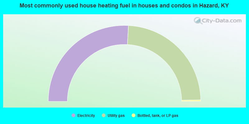
- 51.6%Electricity
- 47.7%Utility gas
- 0.6%Bottled, tank, or LP gas
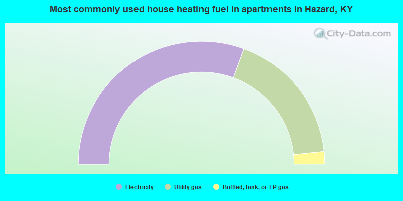
- 61.2%Electricity
- 35.5%Utility gas
- 3.3%Bottled, tank, or LP gas
Hazard compared to Kentucky state average:
- Unemployed percentage below state average.
- Black race population percentage significantly below state average.
- Renting percentage above state average.
- Length of stay since moving in significantly above state average.
- Institutionalized population percentage significantly above state average.
Hazard on our top lists:
- #24 on the list of "Top 101 cities with largest percentage of males in industries: health care and social assistance (population 5,000+)"
- #31 on the list of "Top 101 cities with largest percentage of females in industries: health care and social assistance (population 5,000+)"
- #42 on the list of "Top 101 cities with the largest percentage of people in mental (psychiatric) hospitals or wards (population 1,000+)"
- #48 on the list of "Top 101 cities with the most people taking a taxi to work (population 5,000+)"
- #53 on the list of "Top 101 cities with the most full-time firefighters per 1000 residents (population 5,000+)"
- #56 on the list of "Top 101 cities with largest percentage of males in occupations: community and social service occupations (population 5,000+)"
- #58 on the list of "Top 101 cities with largest percentage of males in occupations: health technologists and technicians (population 5,000+)"
- #63 on the list of "Top 101 cities that people commute into (largest positive percentage daily daytime population change due to commuting) (population 5,000+)"
- #63 on the list of "Top 101 cities with the most full-time park and recreation workers per 1000 residents (population 5,000+)"
- #69 on the list of "Top 101 cities with the largest household incomes disparities (population 5,000+)"
- #71 on the list of "Top 101 cities with the highest number of police officers per 1000 residents (population 5,000+)"
- #88 on the list of "Top 101 cities with largest percentage of males in occupations: healthcare support occupations (population 5,000+)"
- #15 on the list of "Top 101 counties with the smallest number of children under 18 without health insurance coverage in 2000"
- #30 on the list of "Top 101 counties with the lowest Ozone (1-hour) air pollution readings in 2012 (ppm)"
- #38 on the list of "Top 101 counties with the smallest number of people without health insurance coverage in 2000"
- #70 on the list of "Top 101 counties with the lowest ground withdrawal of fresh water for public supply"
- #78 on the list of "Top 101 counties with the lowest percentage of residents relocating to other counties in 2011"

|
Total of 1 patent application in 2008-2024.