Dice, Kentucky
Submit your own pictures of this place and show them to the world
- OSM Map
- General Map
- Google Map
- MSN Map

| Males: 1,249 | |
| Females: 1,235 |
| Median resident age: | 34.8 years |
| Kentucky median age: | 35.9 years |
Zip code: 41701
| Dice: | $43,830 |
| KY: | $59,341 |
Estimated per capita income in 2022: $27,421 (it was $11,844 in 2000)
Dice CCD income, earnings, and wages data
Estimated median house or condo value in 2022: $99,181 (it was $39,800 in 2000)
| Dice: | $99,181 |
| KY: | $196,300 |
Mean prices in 2022: all housing units: $145,504; detached houses: $183,549; townhouses or other attached units: $204,848; mobile homes: $52,921
Detailed information about poverty and poor residents in Dice, KY


- 2,47599.2%White alone
- 120.5%Two or more races
- 70.3%Hispanic
- 10.04%Black alone
- 10.04%Asian alone

Races in Dice detailed stats: ancestries, foreign born residents, place of birth
 Recent articles from our blog. Our writers, many of them Ph.D. graduates or candidates, create easy-to-read articles on a wide variety of topics.
Current Local Time: EST time zone
Elevation: 938 feet
Land area: 45.8 square miles.
Population density: 54 people per square mile (very low).

| Dice CCD: | 0.5% ($199) |
| Kentucky: | 0.8% ($610) |
Nearest city with pop. 50,000+: Huntington, WV  (82.4 miles , pop. 51,475).
Nearest city with pop. 200,000+: Fayette, KY (84.3 miles , pop. 260,512).
Nearest city with pop. 1,000,000+: Chicago, IL (390.1 miles , pop. 2,896,016).
Nearest cities:
), ), ), ), )Latitude: 37.38 N, Longitude: 83.19 W
Area code commonly used in this area: 606


| Here: | 5.4% |
| Kentucky: | 3.8% |

- Educational services (17.4%)
- Mining, quarrying, oil & gas extraction (12.6%)
- Health care (11.2%)
- Construction (6.6%)
- Public administration (5.0%)
- Food & beverage stores (4.6%)
- Accommodation & food services (4.4%)

- Mining, quarrying, oil & gas extraction (21.6%)
- Construction (12.5%)
- Educational services (9.4%)
- Administrative & support & waste management services (6.5%)
- Motor vehicle & parts dealers (5.5%)
- Rail transportation (5.2%)
- Health care (4.2%)

- Educational services (26.5%)
- Health care (19.1%)
- Food & beverage stores (9.7%)
- Apparel (7.9%)
- Public administration (6.2%)
- Accommodation & food services (6.2%)
- Department & other general merchandise stores (5.9%)

- Construction traders workers except carpenters, electricians, painters, plumbers, and construction laborers (6.1%)
- Vehicle and mobile equipment mechanics, installers, and repairers (5.8%)
- Driver/sales workers and truck drivers (5.8%)
- Nursing, psychiatric, and home health aides (4.8%)
- Preschool, kindergarten, elementary, and middle school teachers (4.7%)
- Other sales and related occupations, including supervisors (4.7%)
- Other office and administrative support workers, including supervisors (4.6%)

- Construction traders workers except carpenters, electricians, painters, plumbers, and construction laborers (11.5%)
- Driver/sales workers and truck drivers (10.9%)
- Vehicle and mobile equipment mechanics, installers, and repairers (8.9%)
- Electrical equipment mechanics and other installation, maintenance, and repair workers, including supervisors (5.5%)
- Other protective service workers, including supervisors (4.7%)
- Teachers, secondary school (4.2%)
- Postsecondary teachers (3.9%)

- Nursing, psychiatric, and home health aides (10.3%)
- Preschool, kindergarten, elementary, and middle school teachers (8.5%)
- Cashiers (7.4%)
- Waiters and waitresses (6.2%)
- Other sales and related occupations, including supervisors (5.9%)
- Other office and administrative support workers, including supervisors (5.9%)
- Child care workers (5.6%)
Average climate in Dice, Kentucky
Based on data reported by over 4,000 weather stations


(lower is better)

Air Quality Index (AQI) level in 2022 was 81.6. This is about average.
| City: | 81.6 |
| U.S.: | 72.6 |

Ozone [ppb] level in 2022 was 24.9. This is better than average. Closest monitor was 7.0 miles away from the city center.
| City: | 24.9 |
| U.S.: | 33.3 |

Particulate Matter (PM2.5) [µg/m3] level in 2022 was 9.26. This is about average. Closest monitor was 7.0 miles away from the city center.
| City: | 9.26 |
| U.S.: | 8.11 |
Tornado activity:
Dice-area historical tornado activity is significantly below Kentucky state average. It is 61% smaller than the overall U.S. average.
On 6/9/1961, a category F3 (max. wind speeds 158-206 mph) tornado 37.5 miles away from the Dice place center killed one person and injured 63 people and caused between $500,000 and $5,000,000 in damages.
On 5/18/1995, a category F2 (max. wind speeds 113-157 mph) tornado 10.4 miles away from the place center caused between $50,000 and $500,000 in damages.
Earthquake activity:
Dice-area historical earthquake activity is significantly above Kentucky state average. It is 41% greater than the overall U.S. average.On 7/27/1980 at 18:52:21, a magnitude 5.2 (5.1 MB, 4.7 MS, 5.0 UK, 5.2 UK, Class: Moderate, Intensity: VI - VII) earthquake occurred 70.2 miles away from the city center
On 8/9/2020 at 12:07:37, a magnitude 5.1 (5.1 MW, Depth: 4.7 mi) earthquake occurred 131.8 miles away from Dice center
On 8/23/2011 at 17:51:04, a magnitude 5.8 (5.8 MW, Depth: 3.7 mi) earthquake occurred 290.0 miles away from the city center
On 9/7/1988 at 02:28:09, a magnitude 4.6 (4.5 MB, 4.6 LG, Class: Light, Intensity: IV - V) earthquake occurred 64.7 miles away from Dice center
On 11/30/1973 at 07:48:41, a magnitude 4.7 (4.7 MB, 4.6 ML) earthquake occurred 117.6 miles away from Dice center
On 11/10/2012 at 17:08:14, a magnitude 4.2 (4.2 MW, Depth: 10.6 mi) earthquake occurred 18.5 miles away from Dice center
Magnitude types: regional Lg-wave magnitude (LG), body-wave magnitude (MB), local magnitude (ML), surface-wave magnitude (MS), moment magnitude (MW)
Natural disasters:
The number of natural disasters in Perry County (34) is a lot greater than the US average (15).Major Disasters (Presidential) Declared: 28
Emergencies Declared: 3
Causes of natural disasters: Floods: 25, Storms: 25, Tornadoes: 12, Mudslides: 10, Landslides: 6, Winter Storms: 5, Winds: 3, Snowstorms: 2, Blizzard: 1, Freeze: 1, Hurricane: 1, Snow: 1, Snowfall: 1, Other: 1 (Note: some incidents may be assigned to more than one category).
Hospitals and medical centers near Dice:
- HAZARD HEALTH AND REHABILITATION CENTER (Nursing Home, about 7 miles away; HAZARD, KY)
- MOUNTAIN COMMUNITY HOSPICE (Hospital, about 8 miles away; HAZARD, KY)
- KENTUCKY RIVER DISTRICT HHA (Home Health Center, about 13 miles away; HINDMAN, KY)
- KNOTT COUNTY HEALTH AND REHABILITATION CENTER (Nursing Home, about 13 miles away; HINDMAN, KY)
Colleges/universities with over 2000 students nearest to Dice:
- Hazard Community and Technical College (about 11 miles; Hazard, KY; Full-time enrollment: 2,087)
- Southeast Kentucky Community and Technical College (about 31 miles; Cumberland, KY; FT enrollment: 2,196)
- Big Sandy Community and Technical College (about 31 miles; Prestonsburg, KY; FT enrollment: 2,660)
- Morehead State University (about 58 miles; Morehead, KY; FT enrollment: 7,523)
- Lincoln Memorial University (about 62 miles; Harrogate, TN; FT enrollment: 3,706)
- Eastern Kentucky University (about 66 miles; Richmond, KY; FT enrollment: 13,525)
- University of the Cumberlands (about 70 miles; Williamsburg, KY; FT enrollment: 3,585)
Points of interest:
Notable locations in Dice: Troublesome Creek Volunteer Fire Department (A), Lost Creek Volunteer Fire Department (B), Homeplace Community Center (C). Display/hide their locations on the map
Churches in Dice include: Faith Gospel Witness Mission (A), Hunter Memorial Church (B), New Life Church (C), New Mount Zion Church (D), Orthodox Church (E), Riverside Church (F). Display/hide their locations on the map
Cemeteries: Campbell Cemetery (1), Chestnut Gap Cemetery (2), Hays Cemetery (3), Cockerell Fork Cemetery (4), Allen Cemetery (5), Ary Cemetery (6), Williams Cemetery (7). Display/hide their locations on the map
Streams, rivers, and creeks: Ball Branch (A), Balls Fork (B), Big Branch (C), Brushy Branch (D), Wolfpen Branch (E), Upper Beaverdam Branch (F), Coates Branch (G), Coalstone Branch (H), Trace Fork (I). Display/hide their locations on the map
| This place: | 2.5 people |
| Kentucky: | 2.5 people |
| This place: | 69.8% |
| Whole state: | 66.9% |
| This place: | 7.4% |
| Whole state: | 6.4% |
Likely homosexual households (counted as self-reported same-sex unmarried-partner households)
- Lesbian couples: 0.3% of all households
- Gay men: 0.7% of all households
| This place: | 29.0% |
| Whole state: | 15.8% |
| This place: | 11.3% |
| Whole state: | 6.6% |
For population 15 years and over in Dice:

- Never married: 20.5%
- Now married: 60.1%
- Separated: 2.8%
- Widowed: 6.9%
- Divorced: 12.5%
For population 25 years and over in Dice:
- High school or higher: 56.1%
- Bachelor's degree or higher: 8.4%
- Graduate or professional degree: 4.3%
- Unemployed: 10.4%
- Mean travel time to work (commute): 28.3 minutes


| Here: | 18.9 |
| Kentucky average: | 13.8 |
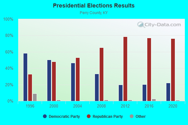
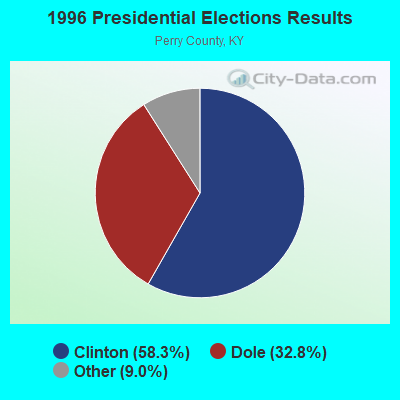
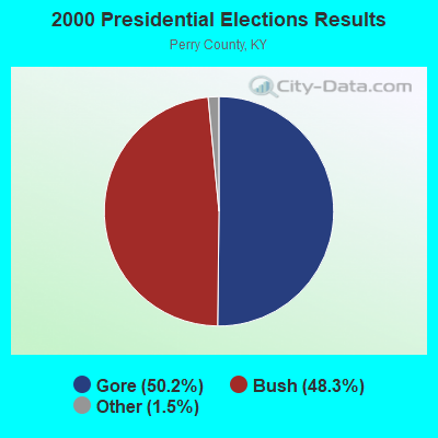
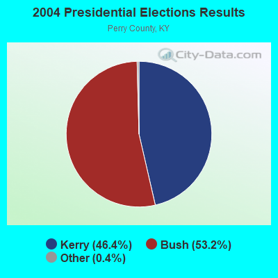
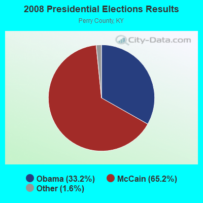
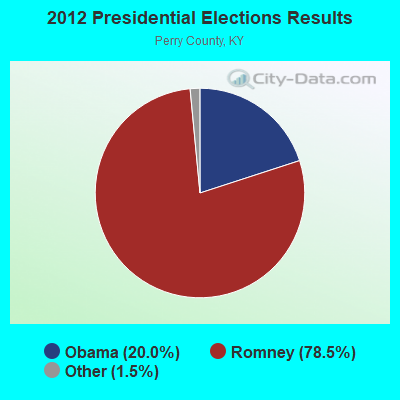
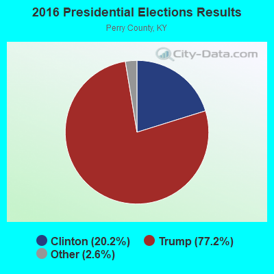
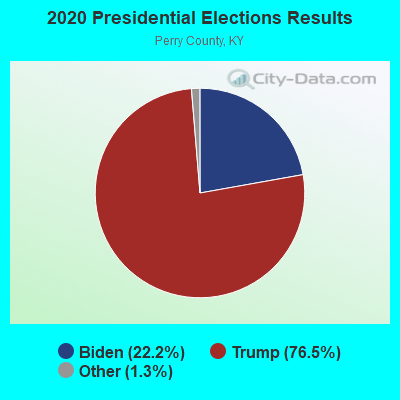
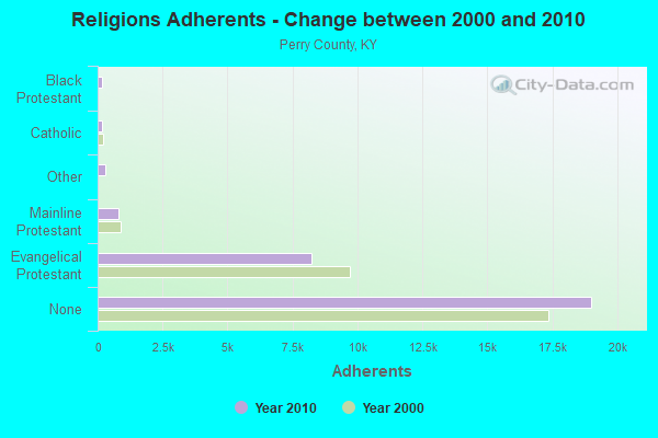
Graphs represent county-level data. Detailed 2008 Election Results
Religion statistics for Dice, KY (based on Perry County data)
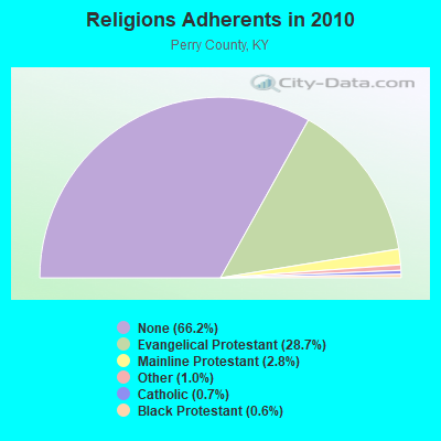
| Religion | Adherents | Congregations |
|---|---|---|
| Evangelical Protestant | 8,245 | 61 |
| Mainline Protestant | 791 | 10 |
| Other | 301 | 1 |
| Catholic | 188 | 1 |
| Black Protestant | 180 | 1 |
| None | 19,007 | - |
Food Environment Statistics:
| Perry County: | 3.09 / 10,000 pop. |
| State: | 2.19 / 10,000 pop. |
| Here: | 1.03 / 10,000 pop. |
| Kentucky: | 0.74 / 10,000 pop. |
| Perry County: | 6.86 / 10,000 pop. |
| Kentucky: | 4.36 / 10,000 pop. |
| Perry County: | 5.14 / 10,000 pop. |
| State: | 5.74 / 10,000 pop. |
| Here: | 10.9% |
| Kentucky: | 11.0% |
| Here: | 34.7% |
| Kentucky: | 30.0% |
| Perry County: | 23.0% |
| Kentucky: | 15.9% |
Strongest AM radio stations in Dice:
- WKIC (1390 AM; 5 kW; HAZARD, KY)
- WEKG (810 AM; daytime; 5 kW; JACKSON, KY; Owner: INTERMOUNTAIN B/CING CO., INC.)
- WMTC (730 AM; 5 kW; VANCLEVE, KY; Owner: THE KENTUCKY MOUNTAIN HOLINESS ASSN.)
- WQXY (1560 AM; daytime; 1 kW; HAZARD, KY; Owner: BLACK GOLD BROADCASTING)
- WKCB (1340 AM; 1 kW; HINDMAN, KY; Owner: HINDMAN BROADCASTING CORPORATION)
- WPRT (960 AM; 5 kW; PRESTONSBURG, KY; Owner: EAST KENTUCKY RADIO NETWORK, INC.)
- WKYH (600 AM; 5 kW; PAINTSVILLE, KY; Owner: HIGHLANDS BROADCASTING CORPORATION)
- WKVL (850 AM; daytime; 50 kW; KNOXVILLE, TN; Owner: HORNE RADIO, LLC)
- WTCW (920 AM; 4 kW; WHITESBURG, KY; Owner: T.C.W. BROADCASTING , INC.)
- WLSI (900 AM; 5 kW; PIKEVILLE, KY; Owner: EAST KENTUCKY BROADCASTING CORPORATION)
- WDOC (1310 AM; 5 kW; PRESTONSBURG, KY)
- WEZC (1480 AM; daytime; 5 kW; NEON, KY; Owner: JESUS COMMUNICATION ILNC.)
- WFSR (970 AM; 5 kW; HARLAN, KY; Owner: EASTERN BROADCASTING COMPAY)
Strongest FM radio stations in Dice:
- WZQQ (97.9 FM; HYDEN, KY; Owner: LESLIE COUNTY BROADCASTING, INC.)
- WJMD (104.7 FM; HAZARD, KY; Owner: HAZARD BROADCASTING SERVICES)
- WSGS (101.1 FM; HAZARD, KY; Owner: MOUNTAIN BROADCASTING SERVICE, INC.)
- WEKH (90.9 FM; HAZARD, KY; Owner: EASTERN KENTUCKY UNIVERSITY)
- WJSN-FM (106.5 FM; JACKSON, KY; Owner: INTERMOUNTAIN BROADCASTING CO.)
- WKCB-FM (107.1 FM; HINDMAN, KY; Owner: HINDMAN BROADCASTING CORPORATION)
- WSEH (102.7 FM; CUMBERLAND, KY; Owner: CUMBERLAND CITY BROADCASTING, INC.)
- WIFX-FM (94.3 FM; JENKINS, KY; Owner: LETCHER COUNTY BROADCASTING, INC)
- WXKQ-FM (103.9 FM; WHITESBURG, KY; Owner: T.C.W. BROADCASTING , INC.)
- WMMT (88.7 FM; WHITESBURG, KY; Owner: APPALSHOP, INCORPORATED)
- WAXM (93.5 FM; BIG STONE GAP, VA; Owner: VALLEY BROADCASTING, INC.)
- WWJD (91.7 FM; PIPPA PASSES, KY; Owner: ALICE LLOYD COLLEGE)
- WDXC (102.3 FM; POUND, VA; Owner: WDXC RADIO, INC.)
- WQHY (95.5 FM; PRESTONSBURG, KY; Owner: WDOC, INC.)
- WTUK (105.1 FM; HARLAN, KY; Owner: EASTERN BROADCASTING COMPANY)
- W223AA (92.5 FM; BIG STONE GAP, VA; Owner: VALLEY BROADCASTING, INC.)
- WPKE-FM (103.1 FM; COAL RUN, KY; Owner: EAST KENTUCKY BROADCASTING CORP.)
- WDHR (93.1 FM; PIKEVILLE, KY; Owner: EAST KENTUCKY BROADCASTING CORP.)
- WZLK (107.5 FM; VIRGIE, KY; Owner: EAST KENTUCKY BROADCASTING CORPORATION)
- WXLR (104.9 FM; HAROLD, KY; Owner: ADAM D GEARHEART)
TV broadcast stations around Dice:
- W26BK (Channel 26; TALBERT, KY; Owner: MS COMMUNICATIONS, LLC)
- WYMT-TV (Channel 57; HAZARD, KY; Owner: WYMT LICENSEE CORP.)
- W16BI (Channel 16; TALBERT, KY; Owner: MS COMMUNICATIONS, LLC)
- W24BT (Channel 24; TALBERT, KY; Owner: MS COMMUNICATIONS, LLC)
- WKHA (Channel 35; HAZARD, KY; Owner: KENTUCKY AUTHORITY FOR EDUCATIONAL TV)
- W31BU (Channel 31; TALBERT, KY; Owner: MS COMMUNICATIONS, LLC)
- W53BQ (Channel 53; TALBERT, KY; Owner: MS COMMUNICATIONS, LLC)
- W69ED (Channel 69; TALBERT, KY; Owner: MS COMMUNICATIONS, LLC)
- W64CM (Channel 64; TALBERT, KY; Owner: MS COMMUNICATIONS, LLC)
- W66DA (Channel 66; TALBERT, KY; Owner: MS COMMUNICATIONS, LLC)
- WLJC-TV (Channel 65; BEATTYVILLE, KY; Owner: HOUR OF HARVEST, INC.)
- WUPX-TV (Channel 67; MOREHEAD, KY; Owner: PAXSON LEXINGTON LICENSE, INC.)
- W54CI (Channel 54; TALBERT, KY; Owner: MS COMMUNICATIONS, LLC)
- W20BO (Channel 20; TALBERT, KY; Owner: MS COMMUNICATIONS, LLC)

Dice fatal accident list:
May 12, 1998 07:12 PM, 15 Mile Creek Rd., Vehicles: 1, Persons: 1, Fatalities: 1

- 79.5%Electricity
- 11.1%Coal or coke
- 3.4%Wood
- 2.5%Bottled, tank, or LP gas
- 1.6%Utility gas
- 0.9%Fuel oil, kerosene, etc.
- 0.9%No fuel used

- 60.3%Electricity
- 21.1%Coal or coke
- 15.7%Fuel oil, kerosene, etc.
- 2.9%Bottled, tank, or LP gas
Dice compared to Kentucky state average:
- Median house value below state average.
- Black race population percentage significantly below state average.
- Hispanic race population percentage significantly below state average.
- Median age below state average.
- Foreign-born population percentage significantly below state average.
- Renting percentage below state average.
- Length of stay since moving in significantly above state average.
- Number of rooms per house significantly below state average.
- House age significantly below state average.
- Percentage of population with a bachelor's degree or higher significantly below state average.