Haddix, Kentucky
Submit your own pictures of this place and show them to the world
- OSM Map
- General Map
- Google Map
- MSN Map

| Males: 1,122 | |
| Females: 1,083 |
| Median resident age: | 33.7 years |
| Kentucky median age: | 35.9 years |
Zip code: 41339
| Haddix: | $36,130 |
| KY: | $59,341 |
Estimated per capita income in 2022: $16,865 (it was $8,356 in 2000)
Haddix CCD income, earnings, and wages data
Estimated median house or condo value in 2022: $43,203 (it was $21,200 in 2000)
| Haddix: | $43,203 |
| KY: | $196,300 |
Mean prices in 2022: all housing units: $108,382; detached houses: $133,291; townhouses or other attached units: $289,655; in 2-unit structures: $119,763; mobile homes: $67,558
Detailed information about poverty and poor residents in Haddix, KY


- 2,25399.2%White alone
- 120.5%Hispanic
- 30.1%Asian alone
- 30.1%Two or more races

Races in Haddix detailed stats: ancestries, foreign born residents, place of birth
 Recent articles from our blog. Our writers, many of them Ph.D. graduates or candidates, create easy-to-read articles on a wide variety of topics.
Current Local Time: EST time zone
Elevation: 760 feet
Land area: 54.0 square miles.
Population density: 41 people per square mile (very low).

| Haddix CCD: | 0.9% ($199) |
| Kentucky: | 0.8% ($610) |
Nearest city with pop. 50,000+: Fayette, KY  (74.0 miles , pop. 260,512).
Nearest city with pop. 1,000,000+: Chicago, IL (381.3 miles , pop. 2,896,016).
Nearest cities:
), ), ), ), )Latitude: 37.44 N, Longitude: 83.37 W
Area code commonly used in this area: 606


| Here: | 7.1% |
| Kentucky: | 3.8% |

- Educational services (13.5%)
- Health care (12.5%)
- Construction (7.1%)
- Department & other general merchandise stores (6.3%)
- Public administration (6.0%)
- Administrative & support & waste management services (5.0%)
- Rail transportation (4.5%)

- Construction (13.5%)
- Administrative & support & waste management services (9.5%)
- Educational services (9.2%)
- Rail transportation (8.6%)
- Mining, quarrying, oil & gas extraction (8.3%)
- Furniture & related product manufacturing (5.7%)
- Truck transportation (5.2%)

- Health care (23.7%)
- Educational services (18.3%)
- Department & other general merchandise stores (11.4%)
- Public administration (7.6%)
- Social assistance (6.6%)
- Food & beverage stores (5.7%)
- Arts, entertainment, recreation (5.4%)

- Retail sales workers, except cashiers (7.7%)
- Building and grounds cleaning and maintenance occupations (7.4%)
- Cashiers (6.5%)
- Nursing, psychiatric, and home health aides (5.7%)
- Other production occupations, including supervisors (5.6%)
- Laborers and material movers, hand (5.3%)
- Preschool, kindergarten, elementary, and middle school teachers (4.8%)

- Other production occupations, including supervisors (10.6%)
- Laborers and material movers, hand (8.9%)
- Construction traders workers except carpenters, electricians, painters, plumbers, and construction laborers (7.2%)
- Preschool, kindergarten, elementary, and middle school teachers (5.2%)
- Other protective service workers, including supervisors (5.2%)
- Electrical equipment mechanics and other installation, maintenance, and repair workers, including supervisors (5.2%)
- Counselors, social workers, and other community and social service specialists (4.6%)

- Cashiers (13.6%)
- Building and grounds cleaning and maintenance occupations (12.3%)
- Nursing, psychiatric, and home health aides (12.0%)
- Retail sales workers, except cashiers (12.0%)
- Child care workers (6.6%)
- Cooks and food preparation workers (4.7%)
- Preschool, kindergarten, elementary, and middle school teachers (4.4%)
Average climate in Haddix, Kentucky
Based on data reported by over 4,000 weather stations


(lower is better)

Air Quality Index (AQI) level in 2022 was 81.6. This is about average.
| City: | 81.6 |
| U.S.: | 72.6 |

Ozone [ppb] level in 2022 was 24.9. This is better than average. Closest monitor was 13.8 miles away from the city center.
| City: | 24.9 |
| U.S.: | 33.3 |

Particulate Matter (PM2.5) [µg/m3] level in 2022 was 9.26. This is about average. Closest monitor was 13.8 miles away from the city center.
| City: | 9.26 |
| U.S.: | 8.11 |
Tornado activity:
Haddix-area historical tornado activity is significantly below Kentucky state average. It is 52% smaller than the overall U.S. average.
On 6/9/1961, a category F3 (max. wind speeds 158-206 mph) tornado 27.3 miles away from the Haddix place center killed one person and injured 63 people and caused between $500,000 and $5,000,000 in damages.
On 5/18/1995, a category F2 (max. wind speeds 113-157 mph) tornado 4.1 miles away from the place center caused between $50,000 and $500,000 in damages.
Earthquake activity:
Haddix-area historical earthquake activity is significantly above Kentucky state average. It is 46% greater than the overall U.S. average.On 7/27/1980 at 18:52:21, a magnitude 5.2 (5.1 MB, 4.7 MS, 5.0 UK, 5.2 UK, Class: Moderate, Intensity: VI - VII) earthquake occurred 61.7 miles away from Haddix center
On 8/9/2020 at 12:07:37, a magnitude 5.1 (5.1 MW, Depth: 4.7 mi) earthquake occurred 142.2 miles away from Haddix center
On 8/23/2011 at 17:51:04, a magnitude 5.8 (5.8 MW, Depth: 3.7 mi) earthquake occurred 299.1 miles away from Haddix center
On 9/7/1988 at 02:28:09, a magnitude 4.6 (4.5 MB, 4.6 LG, Class: Light, Intensity: IV - V) earthquake occurred 56.2 miles away from the city center
On 4/18/2008 at 09:36:59, a magnitude 5.4 (5.1 MB, 4.8 MS, 5.4 MW, 5.2 MW) earthquake occurred 256.2 miles away from Haddix center
On 11/30/1973 at 07:48:41, a magnitude 4.7 (4.7 MB, 4.6 ML) earthquake occurred 118.1 miles away from the city center
Magnitude types: regional Lg-wave magnitude (LG), body-wave magnitude (MB), local magnitude (ML), surface-wave magnitude (MS), moment magnitude (MW)
Natural disasters:
The number of natural disasters in Breathitt County (35) is a lot greater than the US average (15).Major Disasters (Presidential) Declared: 28
Emergencies Declared: 3
Causes of natural disasters: Floods: 25, Storms: 22, Tornadoes: 12, Mudslides: 7, Winter Storms: 6, Landslides: 5, Winds: 3, Snows: 2, Blizzard: 1, Fire: 1, Freeze: 1, Heavy Rain: 1, Hurricane: 1, Snowfall: 1, Snowstorm: 1, Other: 1 (Note: some incidents may be assigned to more than one category).
Colleges/universities with over 2000 students nearest to Haddix:
- Hazard Community and Technical College (about 18 miles; Hazard, KY; Full-time enrollment: 2,087)
- Big Sandy Community and Technical College (about 37 miles; Prestonsburg, KY; FT enrollment: 2,660)
- Southeast Kentucky Community and Technical College (about 39 miles; Cumberland, KY; FT enrollment: 2,196)
- Morehead State University (about 53 miles; Morehead, KY; FT enrollment: 7,523)
- Eastern Kentucky University (about 56 miles; Richmond, KY; FT enrollment: 13,525)
- Lincoln Memorial University (about 62 miles; Harrogate, TN; FT enrollment: 3,706)
- University of the Cumberlands (about 66 miles; Williamsburg, KY; FT enrollment: 3,585)
Points of interest:
Notable locations in Haddix: Curt P O (A), Wolfe Coal Volunteer Fire Department (B). Display/hide their locations on the map
Churches in Haddix include: High Top Church (A), Hilltop Church (B), Whick Church (C), Bethlehem Church (D), Howards Creek Church (E), Drew Memorial Church (F). Display/hide their locations on the map
Cemeteries: Thorpe Cemetery (1), Haddix Cemetery (2), Turner Cemetery (3), Campbell Cemetery (4), Figured Beech Cemetery (5), White and Francis Cemetery (6), Medlock Cemetery (7). Display/hide their locations on the map
Streams, rivers, and creeks: Dry Bread Branch (A), Barn Branch (B), Bear Branch (C), Bush Branch (D), Georges Branch (E), Haddix Fork (F), Howards Creek (G), Kay Fork (H), Tumbling Branch (I). Display/hide their locations on the map
| This place: | 2.7 people |
| Kentucky: | 2.5 people |
| This place: | 74.8% |
| Whole state: | 66.9% |
| This place: | 5.4% |
| Whole state: | 6.4% |
Likely homosexual households (counted as self-reported same-sex unmarried-partner households)
- Lesbian couples: 0.3% of all households
- Gay men: 0.0% of all households
| This place: | 34.6% |
| Whole state: | 15.8% |
| This place: | 12.5% |
| Whole state: | 6.6% |
8 people in hospitals or wards for drug/alcohol abuse in 2000
8 people in mental (psychiatric) hospitals or wards in 2000
For population 15 years and over in Haddix:

- Never married: 26.9%
- Now married: 56.4%
- Separated: 4.1%
- Widowed: 6.7%
- Divorced: 10.0%
For population 25 years and over in Haddix:
- High school or higher: 49.4%
- Bachelor's degree or higher: 4.5%
- Graduate or professional degree: 1.5%
- Unemployed: 11.9%
- Mean travel time to work (commute): 40.2 minutes


| Here: | 18.5 |
| Kentucky average: | 13.8 |
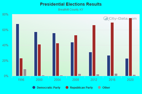
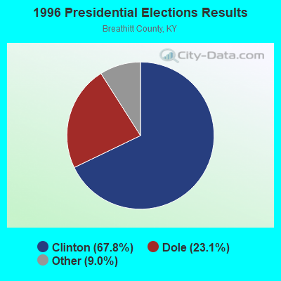
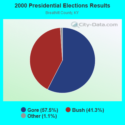
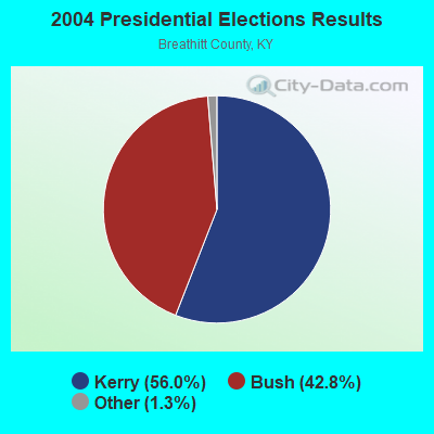
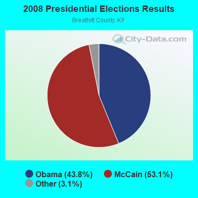
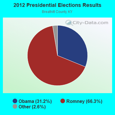
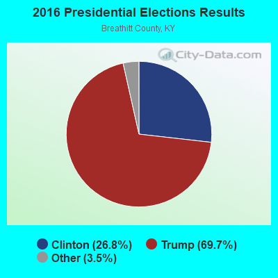
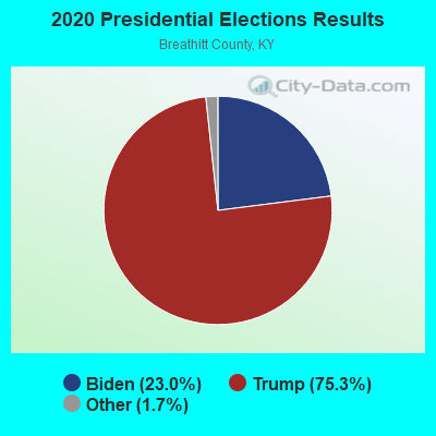
Graphs represent county-level data. Detailed 2008 Election Results
Religion statistics for Haddix, KY (based on Breathitt County data)
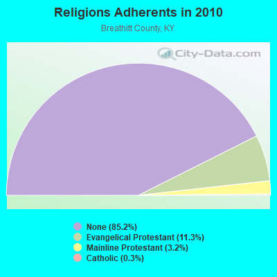
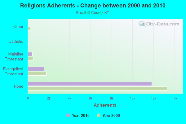
| Religion | Adherents | Congregations |
|---|---|---|
| Evangelical Protestant | 1,563 | 20 |
| Mainline Protestant | 448 | 6 |
| Catholic | 35 | 1 |
| Other | 3 | 1 |
| None | 11,829 | - |
Food Environment Statistics:
| Breathitt County: | 2.55 / 10,000 pop. |
| State: | 2.19 / 10,000 pop. |
| Breathitt County: | 5.10 / 10,000 pop. |
| Kentucky: | 4.36 / 10,000 pop. |
| Breathitt County: | 3.19 / 10,000 pop. |
| Kentucky: | 5.74 / 10,000 pop. |
| This county: | 14.2% |
| State: | 11.0% |
| This county: | 35.5% |
| State: | 30.0% |
| This county: | 18.6% |
| Kentucky: | 15.9% |
Strongest AM radio stations in Haddix:
- WEKG (810 AM; daytime; 5 kW; JACKSON, KY; Owner: INTERMOUNTAIN B/CING CO., INC.)
- WMTC (730 AM; 5 kW; VANCLEVE, KY; Owner: THE KENTUCKY MOUNTAIN HOLINESS ASSN.)
- WKIC (1390 AM; 5 kW; HAZARD, KY)
- WKVL (850 AM; daytime; 50 kW; KNOXVILLE, TN; Owner: HORNE RADIO, LLC)
- WKYH (600 AM; 5 kW; PAINTSVILLE, KY; Owner: HIGHLANDS BROADCASTING CORPORATION)
- WPRT (960 AM; 5 kW; PRESTONSBURG, KY; Owner: EAST KENTUCKY RADIO NETWORK, INC.)
- WKLB (1290 AM; 5 kW; MANCHESTER, KY; Owner: BARKER BROADCASTING COMPANY, INC.)
- WHAS (840 AM; 50 kW; LOUISVILLE, KY; Owner: CLEAR CHANNEL BROADCASTING LICENSES, INC.)
- WTVN (610 AM; 50 kW; COLUMBUS, OH; Owner: CITICASTERS LICENSES, L.P.)
- WLW (700 AM; 50 kW; CINCINNATI, OH; Owner: JACOR BROADCASTING CORPORATION)
- WFSR (970 AM; 5 kW; HARLAN, KY; Owner: EASTERN BROADCASTING COMPAY)
- WTCW (920 AM; 4 kW; WHITESBURG, KY; Owner: T.C.W. BROADCASTING , INC.)
- WQXY (1560 AM; daytime; 1 kW; HAZARD, KY; Owner: BLACK GOLD BROADCASTING)
Strongest FM radio stations in Haddix:
- WJSN-FM (106.5 FM; JACKSON, KY; Owner: INTERMOUNTAIN BROADCASTING CO.)
- WZQQ (97.9 FM; HYDEN, KY; Owner: LESLIE COUNTY BROADCASTING, INC.)
- WJMD (104.7 FM; HAZARD, KY; Owner: HAZARD BROADCASTING SERVICES)
- WSGS (101.1 FM; HAZARD, KY; Owner: MOUNTAIN BROADCASTING SERVICE, INC.)
- WEKH (90.9 FM; HAZARD, KY; Owner: EASTERN KENTUCKY UNIVERSITY)
- WSEH (102.7 FM; CUMBERLAND, KY; Owner: CUMBERLAND CITY BROADCASTING, INC.)
- WMTC-FM (99.9 FM; VANCLEVE, KY; Owner: KENTUCKY MOUNTAIN HOLINESS ASSOC.)
- WLJC (102.1 FM; BEATTYVILLE, KY; Owner: HOUR OF HARVEST, INCORPORATED)
- WAXM (93.5 FM; BIG STONE GAP, VA; Owner: VALLEY BROADCASTING, INC.)
- WIFX-FM (94.3 FM; JENKINS, KY; Owner: LETCHER COUNTY BROADCASTING, INC)
- WXKQ-FM (103.9 FM; WHITESBURG, KY; Owner: T.C.W. BROADCASTING , INC.)
- WMMT (88.7 FM; WHITESBURG, KY; Owner: APPALSHOP, INCORPORATED)
- WKCB-FM (107.1 FM; HINDMAN, KY; Owner: HINDMAN BROADCASTING CORPORATION)
- WOCS (88.3 FM; LEROSE, KY; Owner: BOARD OF REGENTS - MOREHEAD STATE UNIVERSITY)
- WTUK (105.1 FM; HARLAN, KY; Owner: EASTERN BROADCASTING COMPANY)
- WTBK (105.7 FM; MANCHESTER, KY; Owner: MANCHESTER COMMUNICATIONS, INC.)
- WDXC (102.3 FM; POUND, VA; Owner: WDXC RADIO, INC.)
- WQHY (95.5 FM; PRESTONSBURG, KY; Owner: WDOC, INC.)
- W223AA (92.5 FM; BIG STONE GAP, VA; Owner: VALLEY BROADCASTING, INC.)
- WWJD (91.7 FM; PIPPA PASSES, KY; Owner: ALICE LLOYD COLLEGE)
TV broadcast stations around Haddix:
- W26BK (Channel 26; TALBERT, KY; Owner: MS COMMUNICATIONS, LLC)
- W16BI (Channel 16; TALBERT, KY; Owner: MS COMMUNICATIONS, LLC)
- W64CM (Channel 64; TALBERT, KY; Owner: MS COMMUNICATIONS, LLC)
- W66DA (Channel 66; TALBERT, KY; Owner: MS COMMUNICATIONS, LLC)
- W54CI (Channel 54; TALBERT, KY; Owner: MS COMMUNICATIONS, LLC)
- WYMT-TV (Channel 57; HAZARD, KY; Owner: WYMT LICENSEE CORP.)
- WLJC-TV (Channel 65; BEATTYVILLE, KY; Owner: HOUR OF HARVEST, INC.)
- W24BT (Channel 24; TALBERT, KY; Owner: MS COMMUNICATIONS, LLC)
- WUPX-TV (Channel 67; MOREHEAD, KY; Owner: PAXSON LEXINGTON LICENSE, INC.)
- WKHA (Channel 35; HAZARD, KY; Owner: KENTUCKY AUTHORITY FOR EDUCATIONAL TV)
- W31BU (Channel 31; TALBERT, KY; Owner: MS COMMUNICATIONS, LLC)
- W53BQ (Channel 53; TALBERT, KY; Owner: MS COMMUNICATIONS, LLC)
- W69ED (Channel 69; TALBERT, KY; Owner: MS COMMUNICATIONS, LLC)

Haddix fatal accident list:
Nov 21, 2005 05:35 PM, Sr-1110, Sr-397, Lat: 37.483070, Lon: -83.373220, Vehicles: 2, Persons: 3, Fatalities: 1
Nov 4, 2000 02:45 AM, Sr-15, Vehicles: 1, Persons: 1, Fatalities: 1
Feb 4, 1995 02:40 AM, 15, Vehicles: 1, Persons: 3, Fatalities: 1, Drunk persons involved: 1
FCC Registered Antenna Towers:
4- W A Gillum, 0.7 Mile Wnw Of (Lat: 37.491444 Lon: -83.359417), Type: 94.5, Structure height: 21025 m, Overall height: 91.4 m, Registrant: Lukas, Nace, Gutierrez & Sachs, LLP, Pgist@fcclaw.Com, Suite 1200, Mclea-n, Phone: (703) 584-8665
- W A Gillum, 0.7 Mile Wnw Of (Lat: 37.491444 Lon: -83.359417), Type: 94.5, Structure height: 21025 m, Overall height: 91.4 m, Registrant: Lukas, Nace, Gutierrez & Sachs, LLP, Pgist@fcclaw.Com, Suite 1200, Mclea-n, Phone: (703) 584-8665
- W A Gillum, 0.7 Mile Wnw Of (Lat: 37.491444 Lon: -83.359417), Type: 94.5, Structure height: 21025 m, Overall height: 91.4 m, Registrant: Lukas, Nace, Gutierrez & Sachs, LLP, Pgist@fcclaw.Com, Suite 1200, Mclea-n, Phone: (703) 584-8665
- Michael L Johnson, 0.7 Mile Wnw Of (Lat: 37.491444 Lon: -83.359417), Type: 94.5, Structure height: 21025 m, Overall height: 91.4 m, Registrant: East Kentucky Network, LLC D/B/A Appalachian Wireless, Compliance@ekn.Com, , Ivel, Phone: (606) 477-2355

- 49.9%Electricity
- 17.2%Bottled, tank, or LP gas
- 12.6%Coal or coke
- 10.9%Fuel oil, kerosene, etc.
- 7.5%Wood
- 1.0%Utility gas
- 0.9%No fuel used

- 42.0%Electricity
- 23.1%Bottled, tank, or LP gas
- 16.8%Coal or coke
- 9.8%Fuel oil, kerosene, etc.
- 4.2%Utility gas
- 4.2%Wood
Haddix compared to Kentucky state average:
- Median household income below state average.
- Median house value significantly below state average.
- Black race population percentage significantly below state average.
- Hispanic race population percentage significantly below state average.
- Median age below state average.
- Foreign-born population percentage significantly below state average.
- Renting percentage below state average.
- Length of stay since moving in significantly above state average.
- Number of rooms per house significantly below state average.
- House age significantly below state average.
- Number of college students below state average.
- Percentage of population with a bachelor's degree or higher significantly below state average.
Haddix on our top lists:
- #61 on the list of "Top 101 cities with the largest percentage of people in hospitals or wards for drug/alcohol abuse (population 1,000+)"
- #64 (41339) on the list of "Top 101 zip codes with the largest percentage of United States first ancestries (pop 5,000+)"
- #22 on the list of "Top 101 counties with the smallest number of children under 18 without health insurance coverage in 2000"
- #32 on the list of "Top 101 counties with the smallest number of people without health insurance coverage in 2000"
- #36 on the list of "Top 101 counties with the lowest percentage of residents relocating from other counties between 2010 and 2011"