Taulbee, Kentucky
Submit your own pictures of this place and show them to the world
- OSM Map
- General Map
- Google Map
- MSN Map

| Males: 668 | |
| Females: 641 |
| Median resident age: | 35.4 years |
| Kentucky median age: | 35.9 years |
Zip code: 41385
| Taulbee: | $34,244 |
| KY: | $59,341 |
Estimated per capita income in 2022: $20,399 (it was $10,107 in 2000)
Taulbee CCD income, earnings, and wages data
Estimated median house or condo value in 2022: $79,069 (it was $38,800 in 2000)
| Taulbee: | $79,069 |
| KY: | $196,300 |
Mean prices in 2022: all housing units: $108,382; detached houses: $133,291; townhouses or other attached units: $289,655; in 2-unit structures: $119,763; mobile homes: $67,558
Detailed information about poverty and poor residents in Taulbee, KY


- 1,31197.2%White alone
- 161.2%Black alone
- 50.4%Asian alone
- 50.4%Two or more races
- 50.4%Hispanic
- 40.3%American Indian alone
- 30.2%Native Hawaiian and Other
Pacific Islander alone

Races in Taulbee detailed stats: ancestries, foreign born residents, place of birth
 Recent articles from our blog. Our writers, many of them Ph.D. graduates or candidates, create easy-to-read articles on a wide variety of topics.
Current Local Time: EST time zone
Elevation: 760 feet
Land area: 60.2 square miles.
Population density: 22 people per square mile (very low).

| Taulbee CCD: | 1.0% ($404) |
| Kentucky: | 0.8% ($610) |
Nearest city with pop. 50,000+: Fayette, KY  (66.9 miles , pop. 260,512).
Nearest city with pop. 1,000,000+: Chicago, IL (369.8 miles , pop. 2,896,016).
Nearest cities:
), ), ), ), )Latitude: 37.64 N, Longitude: 83.37 W
Area code commonly used in this area: 606


| Here: | 7.1% |
| Kentucky: | 3.8% |

- Educational services (14.8%)
- Health care (10.2%)
- Furniture & related product manufacturing (8.0%)
- Public administration (8.0%)
- Department & other general merchandise stores (6.2%)
- Religious, grantmaking, civic, professional, similar organizations (5.0%)
- Mining, quarrying, oil & gas extraction (4.6%)

- Furniture & related product manufacturing (13.7%)
- Educational services (9.2%)
- Mining, quarrying, oil & gas extraction (7.9%)
- Motor vehicle & parts dealers (7.5%)
- Utilities (7.5%)
- Department & other general merchandise stores (7.2%)
- Public administration (5.8%)

- Educational services (22.5%)
- Health care (20.6%)
- Public administration (11.0%)
- Religious, grantmaking, civic, professional, similar organizations (8.6%)
- Finance & insurance (6.7%)
- Gasoline stations (5.3%)
- Accommodation & food services (5.3%)

- Other production occupations, including supervisors (10.0%)
- Building and grounds cleaning and maintenance occupations (8.8%)
- Laborers and material movers, hand (6.0%)
- Cashiers (5.2%)
- Other management occupations, except farmers and farm managers (5.0%)
- Driver/sales workers and truck drivers (4.6%)
- Health technologists and technicians (4.4%)

- Other production occupations, including supervisors (15.4%)
- Building and grounds cleaning and maintenance occupations (10.3%)
- Driver/sales workers and truck drivers (7.9%)
- Material recording, scheduling, dispatching, and distributing workers (5.5%)
- Other management occupations, except farmers and farm managers (5.1%)
- Extraction workers (5.1%)
- Retail sales workers, except cashiers (4.8%)

- Cashiers (12.4%)
- Cooks and food preparation workers (8.6%)
- Laborers and material movers, hand (7.7%)
- Counselors, social workers, and other community and social service specialists (7.2%)
- Building and grounds cleaning and maintenance occupations (6.7%)
- Health technologists and technicians (6.7%)
- Information and record clerks, except customer service representatives (6.2%)
Average climate in Taulbee, Kentucky
Based on data reported by over 4,000 weather stations


Tornado activity:
Taulbee-area historical tornado activity is significantly below Kentucky state average. It is 47% smaller than the overall U.S. average.
On 6/9/1961, a category F3 (max. wind speeds 158-206 mph) tornado 21.8 miles away from the Taulbee place center killed one person and injured 63 people and caused between $500,000 and $5,000,000 in damages.
On 4/3/1974, a category F4 (max. wind speeds 207-260 mph) tornado 46.6 miles away from the place center killed 7 people and injured 28 people.
Earthquake activity:
Taulbee-area historical earthquake activity is significantly above Kentucky state average. It is 43% greater than the overall U.S. average.On 7/27/1980 at 18:52:21, a magnitude 5.2 (5.1 MB, 4.7 MS, 5.0 UK, 5.2 UK, Class: Moderate, Intensity: VI - VII) earthquake occurred 49.9 miles away from the city center
On 8/9/2020 at 12:07:37, a magnitude 5.1 (5.1 MW, Depth: 4.7 mi) earthquake occurred 149.4 miles away from the city center
On 9/7/1988 at 02:28:09, a magnitude 4.6 (4.5 MB, 4.6 LG, Class: Light, Intensity: IV - V) earthquake occurred 44.4 miles away from the city center
On 8/23/2011 at 17:51:04, a magnitude 5.8 (5.8 MW, Depth: 3.7 mi) earthquake occurred 297.8 miles away from Taulbee center
On 4/18/2008 at 09:36:59, a magnitude 5.4 (5.1 MB, 4.8 MS, 5.4 MW, 5.2 MW) earthquake occurred 252.1 miles away from Taulbee center
On 11/30/1973 at 07:48:41, a magnitude 4.7 (4.7 MB, 4.6 ML) earthquake occurred 131.4 miles away from Taulbee center
Magnitude types: regional Lg-wave magnitude (LG), body-wave magnitude (MB), local magnitude (ML), surface-wave magnitude (MS), moment magnitude (MW)
Natural disasters:
The number of natural disasters in Breathitt County (35) is a lot greater than the US average (15).Major Disasters (Presidential) Declared: 28
Emergencies Declared: 3
Causes of natural disasters: Floods: 25, Storms: 22, Tornadoes: 12, Mudslides: 7, Winter Storms: 6, Landslides: 5, Winds: 3, Snows: 2, Blizzard: 1, Fire: 1, Freeze: 1, Heavy Rain: 1, Hurricane: 1, Snowfall: 1, Snowstorm: 1, Other: 1 (Note: some incidents may be assigned to more than one category).
Colleges/universities with over 2000 students nearest to Taulbee:
- Hazard Community and Technical College (about 31 miles; Hazard, KY; Full-time enrollment: 2,087)
- Big Sandy Community and Technical College (about 33 miles; Prestonsburg, KY; FT enrollment: 2,660)
- Morehead State University (about 39 miles; Morehead, KY; FT enrollment: 7,523)
- Southeast Kentucky Community and Technical College (about 51 miles; Cumberland, KY; FT enrollment: 2,196)
- Eastern Kentucky University (about 52 miles; Richmond, KY; FT enrollment: 13,525)
- Bluegrass Community and Technical College (about 68 miles; Lexington, KY; FT enrollment: 8,560)
- University of Kentucky (about 68 miles; Lexington, KY; FT enrollment: 23,517)
Points of interest:
Churches in Taulbee include: Grace Chapel (A), Zion Hill Mission (B), Mudlick Church (C), Faith Pentecostal Church (D), Blanche Haddix Church (E), Vancleve Church (F). Display/hide their locations on the map
Cemeteries: Puckett Cemetery (1), White Oak Cemetery (2), Clear Fork Cemetery (3), Day Cemetery (4), Dunn Cemetery (5), Field Branch Cemetery (6), Hurst Cemetery (7). Display/hide their locations on the map
Streams, rivers, and creeks: Negro Fork (A), Peggs Fork (B), Big Falling Rock Branch (C), Big Leslie Branch (D), Boone Fork (E), Wells Branch (F), Davis Creek (G), Wolf Pen Branch (H), Turtle Branch (I). Display/hide their locations on the map
| This place: | 2.5 people |
| Kentucky: | 2.5 people |
| This place: | 75.6% |
| Whole state: | 66.9% |
| This place: | 5.8% |
| Whole state: | 6.4% |
Likely homosexual households (counted as self-reported same-sex unmarried-partner households)
- Lesbian couples: 0.4% of all households
- Gay men: 0.2% of all households
| This place: | 36.5% |
| Whole state: | 15.8% |
| This place: | 13.7% |
| Whole state: | 6.6% |
74 people in college dormitories (includes college quarters off campus) in 2000
2 people in other nonhousehold living situations in 2000
For population 15 years and over in Taulbee:

- Never married: 21.0%
- Now married: 63.9%
- Separated: 3.0%
- Widowed: 4.1%
- Divorced: 11.0%
For population 25 years and over in Taulbee:
- High school or higher: 64.5%
- Bachelor's degree or higher: 6.2%
- Graduate or professional degree: 0.8%
- Unemployed: 2.9%
- Mean travel time to work (commute): 32.3 minutes


| Here: | 14.4 |
| Kentucky average: | 13.8 |
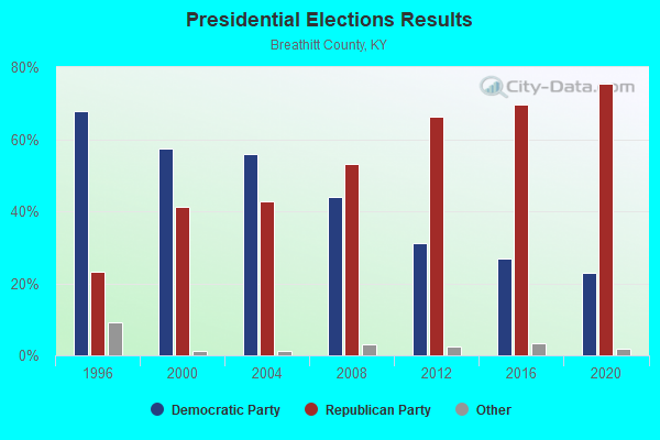
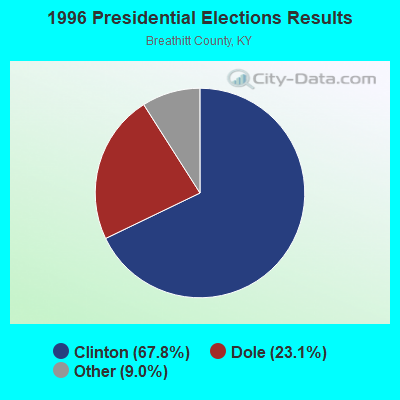
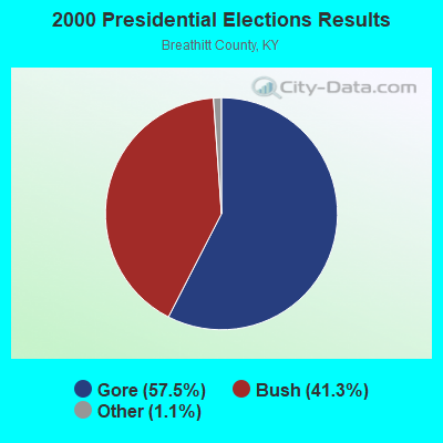
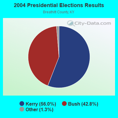
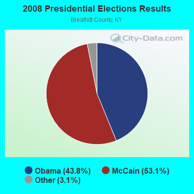
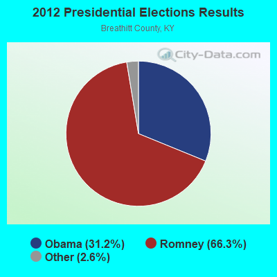
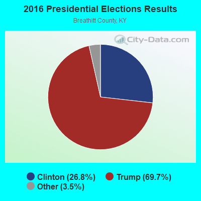
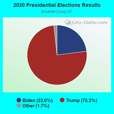
Graphs represent county-level data. Detailed 2008 Election Results
Religion statistics for Taulbee, KY (based on Breathitt County data)
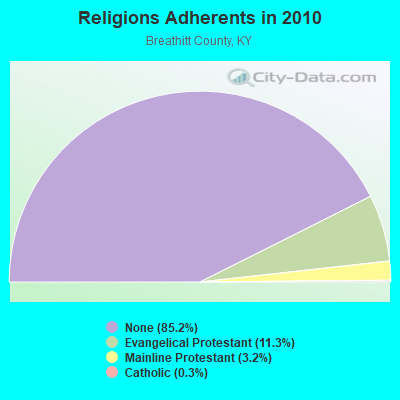
| Religion | Adherents | Congregations |
|---|---|---|
| Evangelical Protestant | 1,563 | 20 |
| Mainline Protestant | 448 | 6 |
| Catholic | 35 | 1 |
| Other | 3 | 1 |
| None | 11,829 | - |
Food Environment Statistics:
| Here: | 2.55 / 10,000 pop. |
| Kentucky: | 2.19 / 10,000 pop. |
| Breathitt County: | 5.10 / 10,000 pop. |
| State: | 4.36 / 10,000 pop. |
| This county: | 3.19 / 10,000 pop. |
| State: | 5.74 / 10,000 pop. |
| Breathitt County: | 14.2% |
| State: | 11.0% |
| Breathitt County: | 35.5% |
| Kentucky: | 30.0% |
| This county: | 18.6% |
| State: | 15.9% |
Strongest AM radio stations in Taulbee:
- WMTC (730 AM; 5 kW; VANCLEVE, KY; Owner: THE KENTUCKY MOUNTAIN HOLINESS ASSN.)
- WEKG (810 AM; daytime; 5 kW; JACKSON, KY; Owner: INTERMOUNTAIN B/CING CO., INC.)
- WKYH (600 AM; 5 kW; PAINTSVILLE, KY; Owner: HIGHLANDS BROADCASTING CORPORATION)
- WPRT (960 AM; 5 kW; PRESTONSBURG, KY; Owner: EAST KENTUCKY RADIO NETWORK, INC.)
- WKVL (850 AM; daytime; 50 kW; KNOXVILLE, TN; Owner: HORNE RADIO, LLC)
- WKIC (1390 AM; 5 kW; HAZARD, KY)
- WTVN (610 AM; 50 kW; COLUMBUS, OH; Owner: CITICASTERS LICENSES, L.P.)
- WLW (700 AM; 50 kW; CINCINNATI, OH; Owner: JACOR BROADCASTING CORPORATION)
- WHAS (840 AM; 50 kW; LOUISVILLE, KY; Owner: CLEAR CHANNEL BROADCASTING LICENSES, INC.)
- WDOC (1310 AM; 5 kW; PRESTONSBURG, KY)
- WRLV (1140 AM; daytime; 1 kW; SALYERSVILLE, KY; Owner: WALLINGFORD BROADCASTING COMPANY, INC)
- WLSI (900 AM; 5 kW; PIKEVILLE, KY; Owner: EAST KENTUCKY BROADCASTING CORPORATION)
- WSAI (1530 AM; 50 kW; CINCINNATI, OH; Owner: JACOR BROADCASTING CORPORATION)
Strongest FM radio stations in Taulbee:
- WJSN-FM (106.5 FM; JACKSON, KY; Owner: INTERMOUNTAIN BROADCASTING CO.)
- WMTC-FM (99.9 FM; VANCLEVE, KY; Owner: KENTUCKY MOUNTAIN HOLINESS ASSOC.)
- WCBJ (103.7 FM; CAMPTON, KY; Owner: MORGAN COUNTY INDUSTRIES INC)
- WLJC (102.1 FM; BEATTYVILLE, KY; Owner: HOUR OF HARVEST, INCORPORATED)
- WSGS (101.1 FM; HAZARD, KY; Owner: MOUNTAIN BROADCASTING SERVICE, INC.)
- WZQQ (97.9 FM; HYDEN, KY; Owner: LESLIE COUNTY BROADCASTING, INC.)
- WJMD (104.7 FM; HAZARD, KY; Owner: HAZARD BROADCASTING SERVICES)
- WEKH (90.9 FM; HAZARD, KY; Owner: EASTERN KENTUCKY UNIVERSITY)
- WSEH (102.7 FM; CUMBERLAND, KY; Owner: CUMBERLAND CITY BROADCASTING, INC.)
- WQHY (95.5 FM; PRESTONSBURG, KY; Owner: WDOC, INC.)
- WIFX-FM (94.3 FM; JENKINS, KY; Owner: LETCHER COUNTY BROADCASTING, INC)
- WSKV-FM (104.9 FM; STANTON, KY; Owner: PARKS BROADCASTING, INC.)
- WAXM (93.5 FM; BIG STONE GAP, VA; Owner: VALLEY BROADCASTING, INC.)
- WXKQ-FM (103.9 FM; WHITESBURG, KY; Owner: T.C.W. BROADCASTING , INC.)
- WMMT (88.7 FM; WHITESBURG, KY; Owner: APPALSHOP, INCORPORATED)
- WMKY (90.3 FM; MOREHEAD, KY; Owner: MOREHEAD STATE UNIVERSITY)
- WOCS (88.3 FM; LEROSE, KY; Owner: BOARD OF REGENTS - MOREHEAD STATE UNIVERSITY)
- WRLV-FM (106.5 FM; SALYERSVILLE, KY; Owner: WALLINGFORD BROADCASTING COMPANY, INC.)
- WKLW-FM (94.7 FM; PAINTSVILLE, KY; Owner: B & G BROADCASTING, INC.)
- WKCB-FM (107.1 FM; HINDMAN, KY; Owner: HINDMAN BROADCASTING CORPORATION)
TV broadcast stations around Taulbee:
- W26BK (Channel 26; TALBERT, KY; Owner: MS COMMUNICATIONS, LLC)
- W16BI (Channel 16; TALBERT, KY; Owner: MS COMMUNICATIONS, LLC)
- W64CM (Channel 64; TALBERT, KY; Owner: MS COMMUNICATIONS, LLC)
- W66DA (Channel 66; TALBERT, KY; Owner: MS COMMUNICATIONS, LLC)
- W54CI (Channel 54; TALBERT, KY; Owner: MS COMMUNICATIONS, LLC)
- WLJC-TV (Channel 65; BEATTYVILLE, KY; Owner: HOUR OF HARVEST, INC.)
- WUPX-TV (Channel 67; MOREHEAD, KY; Owner: PAXSON LEXINGTON LICENSE, INC.)
- WYMT-TV (Channel 57; HAZARD, KY; Owner: WYMT LICENSEE CORP.)
- W24BT (Channel 24; TALBERT, KY; Owner: MS COMMUNICATIONS, LLC)
- WKHA (Channel 35; HAZARD, KY; Owner: KENTUCKY AUTHORITY FOR EDUCATIONAL TV)
FCC Registered Antenna Towers:
6- W A Gillum, 1.4 Miles Ese Of (Lat: 37.632639 Lon: -83.309861), Type: 62.5, Structure height: 21025 m, Overall height: 61 m, Registrant: Lukas, Lafuria, Gutierrez & Sachs, LLP, Pgist@fcclaw.Com, Suite 1200, Tyson-s, Phone: (703) 584-8665
- W A Gillum, 1.4 Miles Ese Of (Lat: 37.632639 Lon: -83.309861), Type: 62.5, Structure height: 21025 m, Overall height: 61 m, Registrant: Lukas, Lafuria, Gutierrez & Sachs, LLP, Pgist@fcclaw.Com, Suite 1200, Tyson-s, Phone: (703) 584-8665
- W A Gillum, 1.4 Miles Ese Of (Lat: 37.632639 Lon: -83.309861), Type: 62.5, Structure height: 21025 m, Overall height: 61 m, Registrant: Lukas, Lafuria, Gutierrez & Sachs, LLP, Pgist@fcclaw.Com, Suite 1200, Tyson-s, Phone: (703) 584-8665
- W. A Gillum, 1.4 Miles Ese Of, Type: 76.2, Structure height: 21025 m, Overall height: 73.2 m, Licensee ID: L, Registrant: East Kentucky Network, LLC D/B/A Appalachian Wireless, Compliance@ekn.Com, , Ivel, Phone: (606) 477-2355
- W.A. Gillum, 1.4 Miles Ese Of (Lat: 37.632639 Lon: -83.309861), Type: 76.2, Structure height: 21025 m, Overall height: 73.2 m, Registrant: East Kentucky Network, LLC D/B/A Appalachian Wireless, Compliance@ekn.Com, , Ivel, Phone: (606) 477-2355
- Michael L Johnson, 1.4 Miles Ese Of (Lat: 37.632639 Lon: -83.309861), Type: 62.5, Structure height: 21025 m, Overall height: 61 m, Registrant: East Kentucky Network, LLC D/B/A Appalachian Wireless, Compliance@ekn.Com, , Ivel, Phone: (606) 477-2355

- 35.8%Electricity
- 29.0%Utility gas
- 19.6%Bottled, tank, or LP gas
- 9.1%Wood
- 4.4%Coal or coke
- 2.1%Fuel oil, kerosene, etc.

- 36.3%Utility gas
- 33.6%Coal or coke
- 15.1%Electricity
- 15.1%Fuel oil, kerosene, etc.
Taulbee compared to Kentucky state average:
- Median household income below state average.
- Median house value significantly below state average.
- Unemployed percentage significantly below state average.
- Black race population percentage significantly below state average.
- Hispanic race population percentage significantly below state average.
- Median age below state average.
- Foreign-born population percentage significantly below state average.
- Renting percentage below state average.
- Length of stay since moving in significantly above state average.
- Number of rooms per house significantly below state average.
- House age significantly below state average.
- Percentage of population with a bachelor's degree or higher significantly below state average.