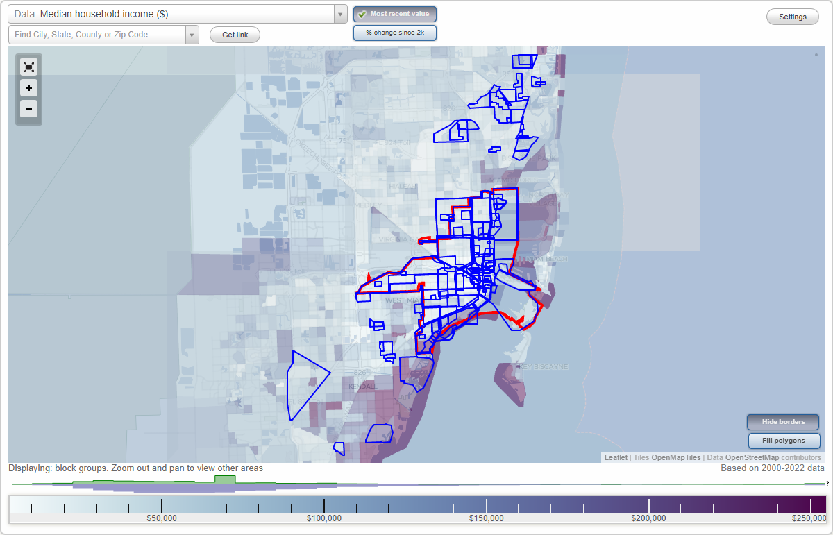
Miami, Florida Neighborhood Map - Income, House Prices, Occupations, Boundaries
Settings
X

- City boundary
- Neighborhood boundaries
Business Search - 14 Million verified businesses
Neighborhoods:
Allapattah, Allen Park, Aventura Town Center, Bay Point, Bayside, Belle Meade, Beverly Terrace, Biscayne Gardens, Biscayne South, Brickell, Brickell Key, Bryan Park, Buena Vista, Buena Vista East, Buena Vista West, Cakegrove, Cambridge Lawns, Cambridge Lawns Historic District, Camp Biscayne, City Center, Club Row, Coconut Grove, Coconut Grove Park, Coral Gate, Coral Way, Design District, Downtown, Downtown Business District, Downtown Coral Gables, Downtown Miami, Downtown North Miami, East Coconut Grove, East Little Havana, Edgewater, Flagami, Floral Park, Gables Estates, Glenwood Heights, Golden Pines, Hadley Park, Highland Lakes, Highland Village, Hometown, Hospital District, Keystone Islands, Kings Bay, Kumquat Village, Liberty City, Lincoln Heights, Little Haiti, Little Havana, Little River, Lower Brickell, Ludlam, Ludlum, Lummus Park, Magnolia Park, Mary Brickell Village, Media and Entertainment District, MiMo, Miami Central Business District, Miami Fashion District, Miami Financial District, Miami Government District, Miami Jewelry District, Miami River, Miami Riverwalk, Midtown, Mision Esperanza, Mitchell Lake Estates, Mitchell Lake Estates, Model City, Morningside, North Miami, Northeast Coconut Grove, Overtown, Park West, Performing Arts District, Pickwick, Port of Miami, Riverside Community, Rockdale, San Souci Estates, Shenandoah, Shorecrest, Silver Bluff, Skylake, South Coconut Grove, South Miami, South River Drive, Southwest Coconut Grove, Spring Garden, Sun Swept Isles, Sunray East, Sunray West, Sunrise Harbor, Sunset VIllas, Thunder Alley, Tigertail, Uleta, Umoja Village, Upper Brickell, Upper East Side, Upper West Side, VOCG, Washington Park, Watson Island, West Flagler, West Kendall, West Little Havana, West Miami, Windward, Wynwood Art DistrictAllapattah neighborhood in Miami statistics: (Find on map)
Area: 4.208 square miles
Population: 36,560
Population density:
Median household income in 2021:
Median rent in in 2021:
Male vs Females
Median age
Housing prices:
Average estimated value of detached houses in 2021 (32.7% of all units):
Average estimated '21 value of housing units in 5-or-more-unit structures (31.1% of all units):
Most popular occupations of males: construction, extraction, and maintenance occupations (30.4%); service occupations (18.0%); transportation occupations (12.4%); sales and office occupations (8.3%); management occupations (except farmers) (5.0%); material moving occupations (4.5%); production occupations (3.3%)
Most popular occupations of females: service occupations (38.5%); sales and office occupations (28.5%); healthcare practitioners and technical occupations (5.2%); management occupations (except farmers) (5.1%); material moving occupations (5.0%); production occupations (3.2%); education, training, and library occupations (3.1%)
Limited-access highways (interstate or state) in this neighborhood: I- 95.
Highways in this neighborhood: State Hwy 948 (NW 36th St); Airport Expy (State Hwy 112); US Hwy 441 (NW 7th Ave); NW 27th Ave (State Hwy 817, State Hwy 9); State Hwy 836 (E West Expy).
Roads and streets: NW 20th St; NW 32nd St; NW 23rd St; NW 28th St; NW 41st St; NW 21st Ter; NW 35th St; NW 30th St; NW 34th St; NW 38th St; NW 33rd St; NW 10th Ave; NW 12th Pl (NW 12th Ave); NW 29th St; NW 17th Ave; NW 26th St; NW 14th Ave; NW 21st St; NW 31st St; NW 22nd St; NW 19th Ave; NW 22nd Ave; NW 15th Ave; NW 24th St; NW 13th Ave; NW 18th Ave; NW North River Dr; NW 24th Ave; NW 11th Ave; NW 8th Ave; NW 25th Ave; NW 27th St; NW 39th St; NW 19th St; NW 22nd Ct; NW 23rd Ave; NW 21st Ave; NW 37th St; NW 17th St; NW 15th St; NW 18th St; NW 16th St; NW 14th St; NW 40th St; NW 6th Ave; NW North River Dr (NW 18th Ter); NW 29th Ter; NW 9th Ave; NW 23rd Ct; NW 25th St; NW 19th Ter; NW 24th Ct; NW 16th Ter; NW 13th Ct; NW 21st Ct; NW 6th Ct; NW 14th Ter; NW 15th Rd; NW 16th Ave; NW 11th Ct; NW 7th Ct; NW 22nd Pl; NW 22nd Ter; NW 12th St; NW 20th Ave; NW 11th Pl; NW 7th Pl; NW 9th Ct; NW 26th Ave; NW 8th Ct; NW 12th Pl; NW 20th Ct; NW 37th Ave; NW 13th Pl; NW 13th Ter; Highland Rd; NW 23rd Ter; NW 6th Pl; NW 18th Ct; NW 10th Ct; Sunnybrook Rd; NW 14th Ct; NW 13th St; NW 31st Ter; NW 7th Avcr; NW 31st Ave; NW 30th Ave; NW 29th Ave; NW 7th Avenue Cir; NW 18th Pl; NW 11th St; NW 35th Ave; NW 36th Ave; NW 33rd Ave; NW 28th Ter; NW 34th Ave; NW 32nd Ave; NW 11th Rd; Spring Garden Rd.
Railroad features: Seaboard Coast Line RR.
Other features: Wagner Creek Cnl.
Other features: Wagner Crk.
Allapattah neighborhood detailed profile
Area: 4.208 square miles
Population: 36,560
Population density:
| Allapattah: | 8,687 people per square mile |
| Miami: | 12,332 people per square mile |
Median household income in 2021:
| Allapattah: | $33,995 |
| Miami: | $48,789 |
Median rent in in 2021:
| Allapattah: | $919 |
| Miami: | $1,309 |
Male vs Females
| Males: | 19,651 |
| Females: | 16,909 |
Median age
| Males: | 37.4 years |
| Females: | 41.3 years |
Housing prices:
Average estimated value of detached houses in 2021 (32.7% of all units):
| Allapattah: | $288,726 |
| Florida: | $399,750 |
Average estimated '21 value of housing units in 5-or-more-unit structures (31.1% of all units):
| Allapattah: | $375,824 |
| Florida: | $369,045 |
Most popular occupations of males: construction, extraction, and maintenance occupations (30.4%); service occupations (18.0%); transportation occupations (12.4%); sales and office occupations (8.3%); management occupations (except farmers) (5.0%); material moving occupations (4.5%); production occupations (3.3%)
Most popular occupations of females: service occupations (38.5%); sales and office occupations (28.5%); healthcare practitioners and technical occupations (5.2%); management occupations (except farmers) (5.1%); material moving occupations (5.0%); production occupations (3.2%); education, training, and library occupations (3.1%)
Limited-access highways (interstate or state) in this neighborhood: I- 95.
Highways in this neighborhood: State Hwy 948 (NW 36th St); Airport Expy (State Hwy 112); US Hwy 441 (NW 7th Ave); NW 27th Ave (State Hwy 817, State Hwy 9); State Hwy 836 (E West Expy).
Roads and streets: NW 20th St; NW 32nd St; NW 23rd St; NW 28th St; NW 41st St; NW 21st Ter; NW 35th St; NW 30th St; NW 34th St; NW 38th St; NW 33rd St; NW 10th Ave; NW 12th Pl (NW 12th Ave); NW 29th St; NW 17th Ave; NW 26th St; NW 14th Ave; NW 21st St; NW 31st St; NW 22nd St; NW 19th Ave; NW 22nd Ave; NW 15th Ave; NW 24th St; NW 13th Ave; NW 18th Ave; NW North River Dr; NW 24th Ave; NW 11th Ave; NW 8th Ave; NW 25th Ave; NW 27th St; NW 39th St; NW 19th St; NW 22nd Ct; NW 23rd Ave; NW 21st Ave; NW 37th St; NW 17th St; NW 15th St; NW 18th St; NW 16th St; NW 14th St; NW 40th St; NW 6th Ave; NW North River Dr (NW 18th Ter); NW 29th Ter; NW 9th Ave; NW 23rd Ct; NW 25th St; NW 19th Ter; NW 24th Ct; NW 16th Ter; NW 13th Ct; NW 21st Ct; NW 6th Ct; NW 14th Ter; NW 15th Rd; NW 16th Ave; NW 11th Ct; NW 7th Ct; NW 22nd Pl; NW 22nd Ter; NW 12th St; NW 20th Ave; NW 11th Pl; NW 7th Pl; NW 9th Ct; NW 26th Ave; NW 8th Ct; NW 12th Pl; NW 20th Ct; NW 37th Ave; NW 13th Pl; NW 13th Ter; Highland Rd; NW 23rd Ter; NW 6th Pl; NW 18th Ct; NW 10th Ct; Sunnybrook Rd; NW 14th Ct; NW 13th St; NW 31st Ter; NW 7th Avcr; NW 31st Ave; NW 30th Ave; NW 29th Ave; NW 7th Avenue Cir; NW 18th Pl; NW 11th St; NW 35th Ave; NW 36th Ave; NW 33rd Ave; NW 28th Ter; NW 34th Ave; NW 32nd Ave; NW 11th Rd; Spring Garden Rd.
Railroad features: Seaboard Coast Line RR.
Other features: Wagner Creek Cnl.
Other features: Wagner Crk.
Allapattah neighborhood detailed profile
Allen Park neighborhood in Miami statistics: (Find on map)
Area: 0.568 square miles
Population: 3,448
Population density:
Median household income in 2021:
Median rent in in 2021:
Male vs Females
Median age
Housing prices:
Average estimated value of detached houses in 2021 (50.1% of all units):
Average estimated value of townhouses or other attached units in 2021 (3.5% of all units):
Average estimated '21 value of housing units in 5-or-more-unit structures (8.8% of all units):
Most popular occupations of males: service occupations (36.2%); transportation occupations (19.5%); production occupations (13.4%); construction, extraction, and maintenance occupations (8.7%); education, training, and library occupations (6.8%); material moving occupations (4.2%); community and social services occupations (3.2%)
Most popular occupations of females: service occupations (39.6%); sales and office occupations (27.0%); healthcare practitioners and technical occupations (12.2%); management occupations (except farmers) (5.7%); education, training, and library occupations (5.5%); production occupations (4.0%); business and financial operations occupations (3.3%)
Highways in this neighborhood: State Hwy 909 (W Dixie Hwy).
Roads and streets: NE 18th Ave; NE 159th St; NE 161st St; NE 151st St; NE 162nd St; NE 160th St; NE 154th St; NE 153rd St; NE 21st Ave; NE 157th Ter; NE 158th St; NE 19th Pl; NE 17th Ave; NE 19th Ct; NE 18th Pl; NE 18th Ct; NE 155th St; NE 154th Ter.
Railroad features: Florida East Coast Rlwy.
Allen Park neighborhood detailed profile
Area: 0.568 square miles
Population: 3,448
Population density:
| Allen Park: | 6,071 people per square mile |
| Miami: | 12,332 people per square mile |
Median household income in 2021:
| Allen Park: | $47,617 |
| Miami: | $48,789 |
Median rent in in 2021:
| Allen Park: | $862 |
| Miami: | $1,309 |
Male vs Females
| Males: | 1,584 |
| Females: | 1,863 |
Median age
| Males: | 36.9 years |
| Females: | 34.5 years |
Housing prices:
Average estimated value of detached houses in 2021 (50.1% of all units):
| Allen Park: | $177,419 |
| Florida: | $399,750 |
Average estimated value of townhouses or other attached units in 2021 (3.5% of all units):
| This neighborhood: | $300,210 |
| Florida: | $293,437 |
Average estimated '21 value of housing units in 5-or-more-unit structures (8.8% of all units):
| Allen Park: | $332,344 |
| Florida: | $369,045 |
Most popular occupations of males: service occupations (36.2%); transportation occupations (19.5%); production occupations (13.4%); construction, extraction, and maintenance occupations (8.7%); education, training, and library occupations (6.8%); material moving occupations (4.2%); community and social services occupations (3.2%)
Most popular occupations of females: service occupations (39.6%); sales and office occupations (27.0%); healthcare practitioners and technical occupations (12.2%); management occupations (except farmers) (5.7%); education, training, and library occupations (5.5%); production occupations (4.0%); business and financial operations occupations (3.3%)
Highways in this neighborhood: State Hwy 909 (W Dixie Hwy).
Roads and streets: NE 18th Ave; NE 159th St; NE 161st St; NE 151st St; NE 162nd St; NE 160th St; NE 154th St; NE 153rd St; NE 21st Ave; NE 157th Ter; NE 158th St; NE 19th Pl; NE 17th Ave; NE 19th Ct; NE 18th Pl; NE 18th Ct; NE 155th St; NE 154th Ter.
Railroad features: Florida East Coast Rlwy.
Allen Park neighborhood detailed profile
Aventura Town Center neighborhood in Miami statistics: (Find on map)
Area: 0.294 square miles
Highways in this neighborhood: State Hwy 856 (NE 192nd St); US Hwy 1 (Biscayne Blvd).
Roads and streets: NE 185th St; NE 190th St; NE 187th St; NE 191st St; NE 29th Ave; NE 193rd St; NE 184 Way; W Country Club Dr; NE 185 St; NE 28th Ct; NE 186th St; NE 188th St; NE 27 Ct.
Aventura Town Center neighborhood detailed profile
Bay Point neighborhood in Miami statistics: (Find on map)
Area: 0.530 square miles
Population: 601
Population density:
Median household income in 2021:
Median rent in in 2021:
Male vs Females
Median age
Housing prices:
Average estimated value of detached houses in 2021 (30.9% of all units):
Average estimated '21 value of housing units in 5-or-more-unit structures (37.7% of all units):
Most popular occupations of males: management occupations (except farmers) (24.5%); sales and office occupations (23.1%); architecture and engineering occupations (16.8%); service occupations (10.5%); construction, extraction, and maintenance occupations (6.7%); transportation occupations (4.6%); healthcare practitioners and technical occupations (3.8%)
Most popular occupations of females: management occupations (except farmers) (25.8%); sales and office occupations (24.8%); architecture and engineering occupations (18.0%); service occupations (14.8%); healthcare practitioners and technical occupations (3.8%); arts, design, entertainment, sports, and media occupations (3.6%); education, training, and library occupations (3.0%)
Highways in this neighborhood: US Hwy 1 (Biscayne Blvd).
Roads and streets: Federal Hwy; Lake Rd; Bay Point Rd; Sabal Palm Rd; NE 55th Ter; Island Rd; NE 50th Ter; NE 51st St; NE 52nd St; NE 52nd Ter; NE 53rd St; Gate Ln; NE 55th St; NE 7th Ave; NE 5th Ave; Melaleuca Ln; Buttonwood Ln; Banyan Ln; Palm Ln; Hibiscus Ln; Pidgeon Plum Ln; Myrica Ln; NE 54th St.
Railroad features: Florida East Coast Rlwy.
Bay Point neighborhood detailed profile
Area: 0.530 square miles
Population: 601
Population density:
| Bay Point (Bay Point Estates): | 1,134 people per square mile |
| Miami: | 12,332 people per square mile |
Median household income in 2021:
| Bay Point (Bay Point Estates): | $82,686 |
| Miami: | $48,789 |
Median rent in in 2021:
| Bay Point (Bay Point Estates): | $1,728 |
| Miami: | $1,309 |
Male vs Females
| Males: | 317 |
| Females: | 284 |
Median age
| Males: | 44.4 years |
| Females: | 43.6 years |
Housing prices:
Average estimated value of detached houses in 2021 (30.9% of all units):
| Bay Point (Bay Point Estates): | $2,518,203 |
| Florida: | $399,750 |
Average estimated '21 value of housing units in 5-or-more-unit structures (37.7% of all units):
| Bay Point (Bay Point Estates): | $239,245 |
| Florida: | $369,045 |
Most popular occupations of males: management occupations (except farmers) (24.5%); sales and office occupations (23.1%); architecture and engineering occupations (16.8%); service occupations (10.5%); construction, extraction, and maintenance occupations (6.7%); transportation occupations (4.6%); healthcare practitioners and technical occupations (3.8%)
Most popular occupations of females: management occupations (except farmers) (25.8%); sales and office occupations (24.8%); architecture and engineering occupations (18.0%); service occupations (14.8%); healthcare practitioners and technical occupations (3.8%); arts, design, entertainment, sports, and media occupations (3.6%); education, training, and library occupations (3.0%)
Highways in this neighborhood: US Hwy 1 (Biscayne Blvd).
Roads and streets: Federal Hwy; Lake Rd; Bay Point Rd; Sabal Palm Rd; NE 55th Ter; Island Rd; NE 50th Ter; NE 51st St; NE 52nd St; NE 52nd Ter; NE 53rd St; Gate Ln; NE 55th St; NE 7th Ave; NE 5th Ave; Melaleuca Ln; Buttonwood Ln; Banyan Ln; Palm Ln; Hibiscus Ln; Pidgeon Plum Ln; Myrica Ln; NE 54th St.
Railroad features: Florida East Coast Rlwy.
Bay Point neighborhood detailed profile
Bayside neighborhood in Miami statistics: (Find on map)
Area: 0.163 square miles
Population: 569
Population density:
Median household income in 2021:
Median rent in in 2021:
Male vs Females
Median age
Most popular occupations of males: management occupations (except farmers) (28.9%); sales and office occupations (13.0%); business and financial operations occupations (11.4%); education, training, and library occupations (10.3%); service occupations (9.1%); computer and mathematical occupations (5.6%); legal occupations (5.5%)
Most popular occupations of females: sales and office occupations (28.0%); management occupations (except farmers) (21.1%); business and financial operations occupations (15.9%); service occupations (11.3%); education, training, and library occupations (6.5%); material moving occupations (4.8%); legal occupations (4.4%)
Highways in this neighborhood: Biscayne Blvd (US Hwy 1).
Roads and streets: NE 72nd St; NE 72nd Ter; NE 71st St; NE 69th St; NE 70th St; NE 68th St; Palm Bay Ct (Palm Bay Plz); NE 10th Ave; NE 8th Ave.
Bayside neighborhood detailed profile
Area: 0.163 square miles
Population: 569
Population density:
| Bayside (Bayside Historic Distric): | 3,489 people per square mile |
| Miami: | 12,332 people per square mile |
Median household income in 2021:
| Bayside (Bayside Historic Distric): | $71,110 |
| Miami: | $48,789 |
Median rent in in 2021:
| Bayside (Bayside Historic Distric): | $1,679 |
| Miami: | $1,309 |
Male vs Females
| Males: | 357 |
| Females: | 211 |
Median age
| Males: | 43.9 years |
| Females: | 45.9 years |
Most popular occupations of males: management occupations (except farmers) (28.9%); sales and office occupations (13.0%); business and financial operations occupations (11.4%); education, training, and library occupations (10.3%); service occupations (9.1%); computer and mathematical occupations (5.6%); legal occupations (5.5%)
Most popular occupations of females: sales and office occupations (28.0%); management occupations (except farmers) (21.1%); business and financial operations occupations (15.9%); service occupations (11.3%); education, training, and library occupations (6.5%); material moving occupations (4.8%); legal occupations (4.4%)
Highways in this neighborhood: Biscayne Blvd (US Hwy 1).
Roads and streets: NE 72nd St; NE 72nd Ter; NE 71st St; NE 69th St; NE 70th St; NE 68th St; Palm Bay Ct (Palm Bay Plz); NE 10th Ave; NE 8th Ave.
Bayside neighborhood detailed profile
Belle Meade neighborhood in Miami statistics: (Find on map)
Area: 0.392 square miles
Population: 1,624
Population density:
Median household income in 2021:
Median rent in in 2021:
Male vs Females
Median age
Most popular occupations of males: management occupations (except farmers) (19.8%); education, training, and library occupations (16.3%); sales and office occupations (15.1%); arts, design, entertainment, sports, and media occupations (10.6%); service occupations (10.3%); healthcare practitioners and technical occupations (7.0%); production occupations (5.4%)
Most popular occupations of females: sales and office occupations (35.8%); business and financial operations occupations (17.9%); service occupations (11.8%); management occupations (except farmers) (11.1%); healthcare practitioners and technical occupations (10.3%); arts, design, entertainment, sports, and media occupations (3.9%); education, training, and library occupations (3.6%)
Highways in this neighborhood: Biscayne Blvd (US Hwy 1).
Roads and streets: NE 72nd St; NE 72nd Ter; NE 73rd St; NE 74th St; NE 71st St; NE 69th St; Belle Meade Isle Dr; NE 70th St; NE 76th St; NE 75th St; NE 8th Ave; NE 77th St; NE 7th Ave; NE 6th Ct; Belle Meade Blvd; NE 68th St; NE 7th Ct; NE 9th Ave; NE 77th Ter; Palm Bay Ct (Palm Bay Plz); NE 10th Ave.
Other features: Little River Cnl.
Belle Meade neighborhood detailed profile
Area: 0.392 square miles
Population: 1,624
Population density:
| Belle Meade: | 4,146 people per square mile |
| Miami: | 12,332 people per square mile |
Median household income in 2021:
| Belle Meade: | $65,958 |
| Miami: | $48,789 |
Median rent in in 2021:
| Belle Meade: | $1,474 |
| Miami: | $1,309 |
Male vs Females
| Males: | 1,009 |
| Females: | 614 |
Median age
| Males: | 38.4 years |
| Females: | 47.3 years |
Most popular occupations of males: management occupations (except farmers) (19.8%); education, training, and library occupations (16.3%); sales and office occupations (15.1%); arts, design, entertainment, sports, and media occupations (10.6%); service occupations (10.3%); healthcare practitioners and technical occupations (7.0%); production occupations (5.4%)
Most popular occupations of females: sales and office occupations (35.8%); business and financial operations occupations (17.9%); service occupations (11.8%); management occupations (except farmers) (11.1%); healthcare practitioners and technical occupations (10.3%); arts, design, entertainment, sports, and media occupations (3.9%); education, training, and library occupations (3.6%)
Highways in this neighborhood: Biscayne Blvd (US Hwy 1).
Roads and streets: NE 72nd St; NE 72nd Ter; NE 73rd St; NE 74th St; NE 71st St; NE 69th St; Belle Meade Isle Dr; NE 70th St; NE 76th St; NE 75th St; NE 8th Ave; NE 77th St; NE 7th Ave; NE 6th Ct; Belle Meade Blvd; NE 68th St; NE 7th Ct; NE 9th Ave; NE 77th Ter; Palm Bay Ct (Palm Bay Plz); NE 10th Ave.
Other features: Little River Cnl.
Belle Meade neighborhood detailed profile
Beverly Terrace neighborhood in Miami statistics: (Find on map)
Area: 0.024 square miles
Population: 279
Population density:
Median household income in 2021:
Median rent in in 2021:
Male vs Females
Median age
Housing prices:
Average estimated value of detached houses in 2021 (1.3% of all units):
Average estimated '21 value of housing units in 5-or-more-unit structures (75.8% of all units):
Most popular occupations of males: management occupations (except farmers) (21.9%); service occupations (16.3%); sales and office occupations (15.3%); construction, extraction, and maintenance occupations (12.1%); transportation occupations (9.8%); business and financial operations occupations (8.3%); education, training, and library occupations (6.1%)
Most popular occupations of females: sales and office occupations (32.1%); management occupations (except farmers) (18.4%); service occupations (16.0%); healthcare practitioners and technical occupations (12.2%); business and financial operations occupations (8.9%); legal occupations (7.4%); arts, design, entertainment, sports, and media occupations (2.0%)
Highways in this neighborhood: US Hwy 1 (Biscayne Blvd).
Roads and streets: NE 32nd St; NE 33rd St; NE 4th Ave.
Beverly Terrace neighborhood detailed profile
Area: 0.024 square miles
Population: 279
Population density:
| Beverly Terrace (Beverly Terrace Historic District): | 11,822 people per square mile |
| Miami: | 12,332 people per square mile |
Median household income in 2021:
| Beverly Terrace (Beverly Terrace Historic District): | $55,370 |
| Miami: | $48,789 |
Median rent in in 2021:
| Beverly Terrace (Beverly Terrace Historic District): | $1,739 |
| Miami: | $1,309 |
Male vs Females
| Males: | 137 |
| Females: | 141 |
Median age
| Males: | 32.5 years |
| Females: | 32.5 years |
Housing prices:
Average estimated value of detached houses in 2021 (1.3% of all units):
| Beverly Terrace (Beverly Terrace Historic District): | $648,741 |
| Florida: | $399,750 |
Average estimated '21 value of housing units in 5-or-more-unit structures (75.8% of all units):
| Beverly Terrace (Beverly Terrace Historic District): | $554,737 |
| Florida: | $369,045 |
Most popular occupations of males: management occupations (except farmers) (21.9%); service occupations (16.3%); sales and office occupations (15.3%); construction, extraction, and maintenance occupations (12.1%); transportation occupations (9.8%); business and financial operations occupations (8.3%); education, training, and library occupations (6.1%)
Most popular occupations of females: sales and office occupations (32.1%); management occupations (except farmers) (18.4%); service occupations (16.0%); healthcare practitioners and technical occupations (12.2%); business and financial operations occupations (8.9%); legal occupations (7.4%); arts, design, entertainment, sports, and media occupations (2.0%)
Highways in this neighborhood: US Hwy 1 (Biscayne Blvd).
Roads and streets: NE 32nd St; NE 33rd St; NE 4th Ave.
Beverly Terrace neighborhood detailed profile
Biscayne Gardens neighborhood in Miami statistics: (Find on map)
Area: 0.635 square miles
Population: 4,360
Population density:
Median household income in 2021:
Median rent in in 2021:
Male vs Females
Median age
Most popular occupations of males: service occupations (50.5%); sales and office occupations (13.7%); education, training, and library occupations (7.8%); production occupations (2.7%); transportation occupations (2.2%); material moving occupations (2.0%); computer and mathematical occupations (1.4%)
Most popular occupations of females: service occupations (42.2%); sales and office occupations (27.2%); healthcare practitioners and technical occupations (12.0%); management occupations (except farmers) (8.7%); education, training, and library occupations (3.5%); production occupations (2.8%); business and financial operations occupations (2.0%)
Limited-access highways (interstate or state) in this neighborhood: I- 95.
Highways in this neighborhood: US Hwy 441 (NW 7th Ave).
Roads and streets: S Biscayne River Dr; NW 151st St; NW 147th St; NW 153rd St; NW 146th St; NW 148th St; NW 6th Ave; NW 150th St; NW 5th Ave; NW 149th St; NW 6th Ct; NW 2nd Ave; NW 3rd Ave; NW 4th Ave; NW 152nd St; S River Dr; Garden Dr; NW 12th Ave; NW 11th Ct; NW 11th Ave; NW 149th Ter; NW 10th Ct; NW 8th Ct; NW 10th Ave; NW 10th Pl; NW 8th Ave; NW 9th Ct; NW 148th Ter; NW 9th Ave; N Miami Ave; NW 7th Ct; NW 16th Dr.
Biscayne Gardens neighborhood detailed profile
Area: 0.635 square miles
Population: 4,360
Population density:
| Biscayne Gardens: | 6,861 people per square mile |
| Miami: | 12,332 people per square mile |
Median household income in 2021:
| Biscayne Gardens: | $55,677 |
| Miami: | $48,789 |
Median rent in in 2021:
| Biscayne Gardens: | $1,618 |
| Miami: | $1,309 |
Male vs Females
| Males: | 2,151 |
| Females: | 2,209 |
Median age
| Males: | 34.6 years |
| Females: | 41.6 years |
Most popular occupations of males: service occupations (50.5%); sales and office occupations (13.7%); education, training, and library occupations (7.8%); production occupations (2.7%); transportation occupations (2.2%); material moving occupations (2.0%); computer and mathematical occupations (1.4%)
Most popular occupations of females: service occupations (42.2%); sales and office occupations (27.2%); healthcare practitioners and technical occupations (12.0%); management occupations (except farmers) (8.7%); education, training, and library occupations (3.5%); production occupations (2.8%); business and financial operations occupations (2.0%)
Limited-access highways (interstate or state) in this neighborhood: I- 95.
Highways in this neighborhood: US Hwy 441 (NW 7th Ave).
Roads and streets: S Biscayne River Dr; NW 151st St; NW 147th St; NW 153rd St; NW 146th St; NW 148th St; NW 6th Ave; NW 150th St; NW 5th Ave; NW 149th St; NW 6th Ct; NW 2nd Ave; NW 3rd Ave; NW 4th Ave; NW 152nd St; S River Dr; Garden Dr; NW 12th Ave; NW 11th Ct; NW 11th Ave; NW 149th Ter; NW 10th Ct; NW 8th Ct; NW 10th Ave; NW 10th Pl; NW 8th Ave; NW 9th Ct; NW 148th Ter; NW 9th Ave; N Miami Ave; NW 7th Ct; NW 16th Dr.
Biscayne Gardens neighborhood detailed profile
Biscayne South neighborhood in Miami statistics: (Find on map)
Area: 0.196 square miles
Population: 172
Population density:
Median household income in 2021:
Median rent in in 2021:
Male vs Females
Median age
Housing prices:
Average estimated value of detached houses in 2021 (22.1% of all units):
Average estimated value of townhouses or other attached units in 2021 (8.1% of all units):
Average estimated '21 value of housing units in 5-or-more-unit structures (40.7% of all units):
Most popular occupations of males: construction, extraction, and maintenance occupations (36.9%); sales and office occupations (14.4%); service occupations (12.9%); transportation occupations (11.4%); management occupations (except farmers) (11.0%); production occupations (3.1%); material moving occupations (1.1%)
Most popular occupations of females: service occupations (57.0%); sales and office occupations (10.4%); production occupations (10.1%); education, training, and library occupations (9.4%); management occupations (except farmers) (5.8%); arts, design, entertainment, sports, and media occupations (4.7%); healthcare practitioners and technical occupations (1.9%)
Highways in this neighborhood: Biscayne Blvd (US Hwy 1); State Hwy 916 (NE 135th St, State Hwy 924).
Roads and streets: Seabreeze Dr (NE 20th Pl); NE 139th St; Highlands Dr; NE 140th St; NE 20th Ct; NE 151st St; NE 146th St.
Railroad features: Florida East Coast Rlwy.
Biscayne South neighborhood detailed profile
Area: 0.196 square miles
Population: 172
Population density:
| Biscayne South: | 876 people per square mile |
| Miami: | 12,332 people per square mile |
Median household income in 2021:
| Biscayne South: | $45,953 |
| Miami: | $48,789 |
Median rent in in 2021:
| Biscayne South: | $755 |
| Miami: | $1,309 |
Male vs Females
| Males: | 77 |
| Females: | 95 |
Median age
| Males: | 43.2 years |
| Females: | 40.3 years |
Housing prices:
Average estimated value of detached houses in 2021 (22.1% of all units):
| Biscayne South: | $177,419 |
| Florida: | $399,750 |
Average estimated value of townhouses or other attached units in 2021 (8.1% of all units):
| This neighborhood: | $300,210 |
| Florida: | $293,437 |
Average estimated '21 value of housing units in 5-or-more-unit structures (40.7% of all units):
| Biscayne South: | $332,344 |
| Florida: | $369,045 |
Most popular occupations of males: construction, extraction, and maintenance occupations (36.9%); sales and office occupations (14.4%); service occupations (12.9%); transportation occupations (11.4%); management occupations (except farmers) (11.0%); production occupations (3.1%); material moving occupations (1.1%)
Most popular occupations of females: service occupations (57.0%); sales and office occupations (10.4%); production occupations (10.1%); education, training, and library occupations (9.4%); management occupations (except farmers) (5.8%); arts, design, entertainment, sports, and media occupations (4.7%); healthcare practitioners and technical occupations (1.9%)
Highways in this neighborhood: Biscayne Blvd (US Hwy 1); State Hwy 916 (NE 135th St, State Hwy 924).
Roads and streets: Seabreeze Dr (NE 20th Pl); NE 139th St; Highlands Dr; NE 140th St; NE 20th Ct; NE 151st St; NE 146th St.
Railroad features: Florida East Coast Rlwy.
Biscayne South neighborhood detailed profile
Brickell neighborhood in Miami statistics: (Find on map)
Area: 0.981 square miles
Limited-access highways (interstate or state) in this neighborhood: I- 95.
Highways in this neighborhood: US Hwy 1 (Brickell Ave); State Hwy 90 (8th St SE, US Hwy 41); State Hwy 90 (SW 7th St); State Hwy 972 (SW 3rd Ave); Rickenbacker Cswy (State Hwy 913).
Roads and streets: S Miami Ave; SW 1st Ave; SW 2nd Ave; Brickell Bay Dr (S Bayshore Dr); SW 15th Rd; SW 12th St; SW 10th St; SE 13th St; SW 11th St; SW 9th St; SE 1st Ave; SW 13th St; SW 17th Rd; SE 5th St; SW 6th St; SE 14th St; SE 15th Rd; SE 25th Rd; SE 6th St; SW 18th Rd; SE 12th St; SW 14th St; SE 14th Ln; SE 14th Ter; SE 9th St; SE 11th St; SE 12th Ter; SE 10th St; SW 25th Rd; SW 26th Rd; SW 5th St; SW 19th Rd; SW 18th Ter; SW 2nd Ct; SW 1st Ct; SW 14th Ter; Brickell Key Dr; SE 26th Rd; SW Miami Avenue Rd; SW 21st Rd; SW 22nd Rd; SW 23rd Rd; SW 20th Rd; SW 24th Rd; SW 16th Rd; SW 6th Ter; SW 4th St.
Railroad features: Florida East Coast Rlwy.
Brickell neighborhood detailed profile
Brickell Key neighborhood in Miami statistics: (Find on map)
Area: 0.147 square miles
Roads and streets: Brickell Key Dr; Brickell Key Blvd; Claughton Island Dr.
Brickell Key neighborhood detailed profile
Area: 0.147 square miles
Roads and streets: Brickell Key Dr; Brickell Key Blvd; Claughton Island Dr.
Brickell Key neighborhood detailed profile
Bryan Park neighborhood in Miami statistics: (Find on map)
Area: 0.287 square miles
Population: 3,880
Population density:
Median household income in 2021:
Median rent in in 2021:
Male vs Females
Median age
Housing prices:
Average estimated value of detached houses in 2021 (35.2% of all units):
Average estimated value of townhouses or other attached units in 2021 (18.6% of all units):
Average estimated value of housing units in 2-unit structures in 2021 (12.6% of all units):
Average estimated '21 value of housing units in 5-or-more-unit structures (6.1% of all units):
Most popular occupations of males: service occupations (21.2%); construction, extraction, and maintenance occupations (16.3%); sales and office occupations (15.2%); business and financial operations occupations (12.5%); management occupations (except farmers) (8.5%); transportation occupations (7.9%); healthcare practitioners and technical occupations (3.2%)
Most popular occupations of females: sales and office occupations (54.0%); service occupations (14.5%); education, training, and library occupations (8.1%); construction, extraction, and maintenance occupations (5.8%); healthcare practitioners and technical occupations (5.0%); management occupations (except farmers) (4.0%); material moving occupations (3.4%)
Highways in this neighborhood: 8th St SE (State Hwy 90, US Hwy 41); SW 27th Ave (State Hwy 9, State Hwy 817).
Roads and streets: SW 10th St; SW 11th St; SW 9th St; SW 12th St; SW 15th St; SW 13th St; SW 14th St; SW 22nd Ave; SW 24th Ave; SW 25th Ave; SW 23rd Ave; SW 11th Ter; SW 24th Ct; SW 22nd Ct; SW 23rd Ct.
Bryan Park neighborhood detailed profile
Area: 0.287 square miles
Population: 3,880
Population density:
| Bryan Park: | 13,515 people per square mile |
| Miami: | 12,332 people per square mile |
Median household income in 2021:
| Bryan Park: | $47,488 |
| Miami: | $48,789 |
Median rent in in 2021:
| Bryan Park: | $1,184 |
| Miami: | $1,309 |
Male vs Females
| Males: | 1,806 |
| Females: | 2,073 |
Median age
| Males: | 39.3 years |
| Females: | 47.4 years |
Housing prices:
Average estimated value of detached houses in 2021 (35.2% of all units):
| Bryan Park: | $486,672 |
| Florida: | $399,750 |
Average estimated value of townhouses or other attached units in 2021 (18.6% of all units):
| This neighborhood: | $576,396 |
| Florida: | $293,437 |
Average estimated value of housing units in 2-unit structures in 2021 (12.6% of all units):
| This neighborhood: | $328,427 |
| Florida: | $321,785 |
Average estimated '21 value of housing units in 5-or-more-unit structures (6.1% of all units):
| Bryan Park: | $384,423 |
| Florida: | $369,045 |
Most popular occupations of males: service occupations (21.2%); construction, extraction, and maintenance occupations (16.3%); sales and office occupations (15.2%); business and financial operations occupations (12.5%); management occupations (except farmers) (8.5%); transportation occupations (7.9%); healthcare practitioners and technical occupations (3.2%)
Most popular occupations of females: sales and office occupations (54.0%); service occupations (14.5%); education, training, and library occupations (8.1%); construction, extraction, and maintenance occupations (5.8%); healthcare practitioners and technical occupations (5.0%); management occupations (except farmers) (4.0%); material moving occupations (3.4%)
Highways in this neighborhood: 8th St SE (State Hwy 90, US Hwy 41); SW 27th Ave (State Hwy 9, State Hwy 817).
Roads and streets: SW 10th St; SW 11th St; SW 9th St; SW 12th St; SW 15th St; SW 13th St; SW 14th St; SW 22nd Ave; SW 24th Ave; SW 25th Ave; SW 23rd Ave; SW 11th Ter; SW 24th Ct; SW 22nd Ct; SW 23rd Ct.
Bryan Park neighborhood detailed profile
Buena Vista neighborhood in Miami statistics: (Find on map)
Area: 1.144 square miles
Population: 10,338
Population density:
Median household income in 2021:
Median rent in in 2021:
Male vs Females
Median age
Housing prices:
Average estimated value of detached houses in 2021 (57.0% of all units):
Average estimated '21 value of housing units in 5-or-more-unit structures (20.5% of all units):
Most popular occupations of males: service occupations (28.7%); sales and office occupations (14.6%); management occupations (except farmers) (8.8%); farming, fishing, and forestry occupations (8.1%); transportation occupations (7.7%); construction, extraction, and maintenance occupations (7.3%); material moving occupations (5.3%)
Most popular occupations of females: service occupations (23.8%); sales and office occupations (23.2%); community and social services occupations (8.8%); business and financial operations occupations (8.7%); healthcare practitioners and technical occupations (8.6%); management occupations (except farmers) (6.5%); education, training, and library occupations (5.5%)
Limited-access highways (interstate or state) in this neighborhood: Julia Tuttle Cswy (I- 195); I- 95.
Highways in this neighborhood: .
Roads and streets: N Miami Ave; NW 2nd Ave; NW 3rd Ave; NW 1st Ave; NE 2nd Ave; NW 6th Ave; NW 5th Ave; Federal Hwy; NW 47th St; NW 53rd St; NE 54th St; NW 46th St; NE 1st Ave; NW 54th St; NW 52nd St; NW 50th St; NW 51st St; NW 49th St; NW 48th St; NW 42nd St; NW 45th St; NW 44th St; NW 41st St; NW 40th St; NW 37th St; NE 4th Ave; NW 39th St; NE 51st St; NE 48th St; NE 47th St; NW 47th Ter; NE 53rd St; NE 46th St; NW 43rd St; NE 45th St; NE 50th St; NE 44th St; NE 43rd St; NW 6th Ct; NE 1st Ct; NE 42nd St; NE 39th St; NE 52nd St; NW 38th St; NE 38th St; NE 49th St; NE 40th St; NE 41st St; NE 50th Ter; N E 49th St; NE Miami Ct; NE 48th Ter; NE Miami Pl; N Federal Hwy; NE 3rd Ct; NE 2nd Ct; NE 52nd Ter; NW 4th Pl; NE 3rd Ave; Miami Pl.
Railroad features: Florida East Coast Rlwy.
Buena Vista neighborhood detailed profile
Area: 1.144 square miles
Population: 10,338
Population density:
| Buena Vista: | 9,037 people per square mile |
| Miami: | 12,332 people per square mile |
Median household income in 2021:
| Buena Vista: | $45,201 |
| Miami: | $48,789 |
Median rent in in 2021:
| Buena Vista: | $1,248 |
| Miami: | $1,309 |
Male vs Females
| Males: | 5,065 |
| Females: | 5,272 |
Median age
| Males: | 37.7 years |
| Females: | 37.1 years |
Housing prices:
Average estimated value of detached houses in 2021 (57.0% of all units):
| Buena Vista: | $463,328 |
| Florida: | $399,750 |
Average estimated '21 value of housing units in 5-or-more-unit structures (20.5% of all units):
| Buena Vista: | $365,660 |
| Florida: | $369,045 |
Most popular occupations of males: service occupations (28.7%); sales and office occupations (14.6%); management occupations (except farmers) (8.8%); farming, fishing, and forestry occupations (8.1%); transportation occupations (7.7%); construction, extraction, and maintenance occupations (7.3%); material moving occupations (5.3%)
Most popular occupations of females: service occupations (23.8%); sales and office occupations (23.2%); community and social services occupations (8.8%); business and financial operations occupations (8.7%); healthcare practitioners and technical occupations (8.6%); management occupations (except farmers) (6.5%); education, training, and library occupations (5.5%)
Limited-access highways (interstate or state) in this neighborhood: Julia Tuttle Cswy (I- 195); I- 95.
Highways in this neighborhood: .
Roads and streets: N Miami Ave; NW 2nd Ave; NW 3rd Ave; NW 1st Ave; NE 2nd Ave; NW 6th Ave; NW 5th Ave; Federal Hwy; NW 47th St; NW 53rd St; NE 54th St; NW 46th St; NE 1st Ave; NW 54th St; NW 52nd St; NW 50th St; NW 51st St; NW 49th St; NW 48th St; NW 42nd St; NW 45th St; NW 44th St; NW 41st St; NW 40th St; NW 37th St; NE 4th Ave; NW 39th St; NE 51st St; NE 48th St; NE 47th St; NW 47th Ter; NE 53rd St; NE 46th St; NW 43rd St; NE 45th St; NE 50th St; NE 44th St; NE 43rd St; NW 6th Ct; NE 1st Ct; NE 42nd St; NE 39th St; NE 52nd St; NW 38th St; NE 38th St; NE 49th St; NE 40th St; NE 41st St; NE 50th Ter; N E 49th St; NE Miami Ct; NE 48th Ter; NE Miami Pl; N Federal Hwy; NE 3rd Ct; NE 2nd Ct; NE 52nd Ter; NW 4th Pl; NE 3rd Ave; Miami Pl.
Railroad features: Florida East Coast Rlwy.
Buena Vista neighborhood detailed profile
Buena Vista East neighborhood in Miami statistics: (Find on map)
Area: 0.125 square miles
Population: 1,181
Population density:
Median household income in 2021:
Median rent in in 2021:
Male vs Females
Median age
Average estimated value of detached houses in 2021 (56.2% of all units):
Most popular occupations of males: service occupations (27.8%); management occupations (except farmers) (17.0%); farming, fishing, and forestry occupations (15.1%); material moving occupations (13.2%); transportation occupations (9.5%); arts, design, entertainment, sports, and media occupations (9.4%); sales and office occupations (6.0%)
Most popular occupations of females: service occupations (22.4%); business and financial operations occupations (21.7%); education, training, and library occupations (11.3%); community and social services occupations (10.6%); sales and office occupations (10.1%); healthcare practitioners and technical occupations (9.2%); management occupations (except farmers) (4.9%)
Roads and streets: N Miami Ave; NW 2nd Ave; NW 1st Ave; NW 45th St; NW 44th St; NW 46th St; NW 42nd St; NW 47th Ter; NW 48th St; NW 47th St.
Buena Vista East neighborhood detailed profile
Area: 0.125 square miles
Population: 1,181
Population density:
| Buena Vista East (Buena Vista East Historic District): | 9,421 people per square mile |
| Miami: | 12,332 people per square mile |
Median household income in 2021:
| Buena Vista East (Buena Vista East Historic District): | $63,463 |
| Miami: | $48,789 |
Median rent in in 2021:
| Buena Vista East (Buena Vista East Historic District): | $1,200 |
| Miami: | $1,309 |
Male vs Females
| Males: | 552 |
| Females: | 629 |
Median age
| Males: | 42.3 years |
| Females: | 42.0 years |
Average estimated value of detached houses in 2021 (56.2% of all units):
| Buena Vista East (Buena Vista East Historic District): | $386,636 |
| Florida: | $399,750 |
Most popular occupations of males: service occupations (27.8%); management occupations (except farmers) (17.0%); farming, fishing, and forestry occupations (15.1%); material moving occupations (13.2%); transportation occupations (9.5%); arts, design, entertainment, sports, and media occupations (9.4%); sales and office occupations (6.0%)
Most popular occupations of females: service occupations (22.4%); business and financial operations occupations (21.7%); education, training, and library occupations (11.3%); community and social services occupations (10.6%); sales and office occupations (10.1%); healthcare practitioners and technical occupations (9.2%); management occupations (except farmers) (4.9%)
Roads and streets: N Miami Ave; NW 2nd Ave; NW 1st Ave; NW 45th St; NW 44th St; NW 46th St; NW 42nd St; NW 47th Ter; NW 48th St; NW 47th St.
Buena Vista East neighborhood detailed profile
Buena Vista West neighborhood in Miami statistics: (Find on map)
Area: 0.707 square miles
Population: 6,956
Population density:
Median household income in 2021:
Median rent in in 2021:
Male vs Females
Median age
Housing prices:
Average estimated value of detached houses in 2021 (68.3% of all units):
Average estimated '21 value of housing units in 5-or-more-unit structures (12.3% of all units):
Most popular occupations of males: service occupations (22.1%); sales and office occupations (15.8%); farming, fishing, and forestry occupations (14.0%); material moving occupations (8.6%); construction, extraction, and maintenance occupations (7.3%); management occupations (except farmers) (7.0%); transportation occupations (6.2%)
Most popular occupations of females: service occupations (23.2%); sales and office occupations (17.7%); business and financial operations occupations (13.3%); community and social services occupations (8.4%); education, training, and library occupations (8.1%); healthcare practitioners and technical occupations (7.9%); management occupations (except farmers) (5.6%)
Limited-access highways (interstate or state) in this neighborhood: I- 95; Julia Tuttle Cswy (I- 195).
Highways in this neighborhood: .
Roads and streets: N Miami Ave; NW 1st Ave; NW 2nd Ave; NW 3rd Ave; NW 6th Ave; NW 5th Ave; NW 47th St; NW 53rd St; NW 46th St; NW 54th St; NW 52nd St; NW 50th St; NW 51st St; NW 49th St; NW 48th St; NW 42nd St; NW 45th St; NW 44th St; NW 41st St; NW 40th St; NW 39th St; NW 47th Ter; NW 43rd St; NW 38th St; NW 6th Ct; NW 4th Pl; NE 54th St.
Buena Vista West neighborhood detailed profile
Area: 0.707 square miles
Population: 6,956
Population density:
| Buena Vista West: | 9,845 people per square mile |
| Miami: | 12,332 people per square mile |
Median household income in 2021:
| Buena Vista West: | $45,120 |
| Miami: | $48,789 |
Median rent in in 2021:
| Buena Vista West: | $1,154 |
| Miami: | $1,309 |
Male vs Females
| Males: | 3,233 |
| Females: | 3,723 |
Median age
| Males: | 38.4 years |
| Females: | 38.0 years |
Housing prices:
Average estimated value of detached houses in 2021 (68.3% of all units):
| Buena Vista West: | $518,486 |
| Florida: | $399,750 |
Average estimated '21 value of housing units in 5-or-more-unit structures (12.3% of all units):
| Buena Vista West: | $375,824 |
| Florida: | $369,045 |
Most popular occupations of males: service occupations (22.1%); sales and office occupations (15.8%); farming, fishing, and forestry occupations (14.0%); material moving occupations (8.6%); construction, extraction, and maintenance occupations (7.3%); management occupations (except farmers) (7.0%); transportation occupations (6.2%)
Most popular occupations of females: service occupations (23.2%); sales and office occupations (17.7%); business and financial operations occupations (13.3%); community and social services occupations (8.4%); education, training, and library occupations (8.1%); healthcare practitioners and technical occupations (7.9%); management occupations (except farmers) (5.6%)
Limited-access highways (interstate or state) in this neighborhood: I- 95; Julia Tuttle Cswy (I- 195).
Highways in this neighborhood: .
Roads and streets: N Miami Ave; NW 1st Ave; NW 2nd Ave; NW 3rd Ave; NW 6th Ave; NW 5th Ave; NW 47th St; NW 53rd St; NW 46th St; NW 54th St; NW 52nd St; NW 50th St; NW 51st St; NW 49th St; NW 48th St; NW 42nd St; NW 45th St; NW 44th St; NW 41st St; NW 40th St; NW 39th St; NW 47th Ter; NW 43rd St; NW 38th St; NW 6th Ct; NW 4th Pl; NE 54th St.
Buena Vista West neighborhood detailed profile
Cakegrove neighborhood in Miami statistics: (Find on map)
Area: 0.890 square miles
Population: 7,057
Population density:
Median household income in 2021:
Median rent in in 2021:
Male vs Females
Median age
Most popular occupations of males: service occupations (30.0%); construction, extraction, and maintenance occupations (17.0%); production occupations (12.5%); material moving occupations (8.6%); management occupations (except farmers) (6.4%); healthcare practitioners and technical occupations (5.9%); education, training, and library occupations (5.5%)
Most popular occupations of females: service occupations (34.1%); sales and office occupations (17.5%); production occupations (14.2%); management occupations (except farmers) (9.6%); healthcare practitioners and technical occupations (9.3%); business and financial operations occupations (8.4%); life, physical, and social science occupations (2.2%)
Highways in this neighborhood: State Hwy 826 (NE 163rd St).
Roads and streets: NE 159th St; NE 160th St; NE 158th St; NE 10th Ave; NE 12th Ave; NE 9th Ave; NE 13th Ave; NE 162nd St; NE 157th St; NE 161st St; NE 155th St; NE 8th Ave; NE 14th Ave; NE 15th Ave; NE 11th Ct; NE 11th Ave; NE 155th Ter; NE 156th St; NE 157th Ter; NE 156th Ter; Miami Dr; NE 10th Ct; N Miami Beach Blvd; NE 160th Ter; NE 168th St; NE 8th Ct; NE 164th St; NE 167th St; NE 154th St; NE 166th St; NE 165th Ter; NE 161st Ter; NE 169th St; NE 165th St; NE 9th Pl; NE 16th Ave; NE 151st Ter; NE 154th Ter; NE 9th Ct; NE 152nd Ter; NE 153rd Ter; NE 6th Ct; NE 170th St; NE 15th Ct; NE 15th Pl; NE 153rd St; NE 152nd St; NE 14th Ct; NE 7th Ct; NE 12th Ct; NE 8th Pl; NE 7th Ave.
Cakegrove neighborhood detailed profile
Area: 0.890 square miles
Population: 7,057
Population density:
| Cakegrove: | 7,931 people per square mile |
| Miami: | 12,332 people per square mile |
Median household income in 2021:
| Cakegrove: | $48,912 |
| Miami: | $48,789 |
Median rent in in 2021:
| Cakegrove: | $1,326 |
| Miami: | $1,309 |
Male vs Females
| Males: | 3,480 |
| Females: | 3,576 |
Median age
| Males: | 33.7 years |
| Females: | 40.8 years |
Most popular occupations of males: service occupations (30.0%); construction, extraction, and maintenance occupations (17.0%); production occupations (12.5%); material moving occupations (8.6%); management occupations (except farmers) (6.4%); healthcare practitioners and technical occupations (5.9%); education, training, and library occupations (5.5%)
Most popular occupations of females: service occupations (34.1%); sales and office occupations (17.5%); production occupations (14.2%); management occupations (except farmers) (9.6%); healthcare practitioners and technical occupations (9.3%); business and financial operations occupations (8.4%); life, physical, and social science occupations (2.2%)
Highways in this neighborhood: State Hwy 826 (NE 163rd St).
Roads and streets: NE 159th St; NE 160th St; NE 158th St; NE 10th Ave; NE 12th Ave; NE 9th Ave; NE 13th Ave; NE 162nd St; NE 157th St; NE 161st St; NE 155th St; NE 8th Ave; NE 14th Ave; NE 15th Ave; NE 11th Ct; NE 11th Ave; NE 155th Ter; NE 156th St; NE 157th Ter; NE 156th Ter; Miami Dr; NE 10th Ct; N Miami Beach Blvd; NE 160th Ter; NE 168th St; NE 8th Ct; NE 164th St; NE 167th St; NE 154th St; NE 166th St; NE 165th Ter; NE 161st Ter; NE 169th St; NE 165th St; NE 9th Pl; NE 16th Ave; NE 151st Ter; NE 154th Ter; NE 9th Ct; NE 152nd Ter; NE 153rd Ter; NE 6th Ct; NE 170th St; NE 15th Ct; NE 15th Pl; NE 153rd St; NE 152nd St; NE 14th Ct; NE 7th Ct; NE 12th Ct; NE 8th Pl; NE 7th Ave.
Cakegrove neighborhood detailed profile
Cambridge Lawns neighborhood in Miami statistics: (Find on map)
Area: 0.585 square miles
Population: 5,682
Population density:
Median household income in 2021:
Median rent in in 2021:
Male vs Females
Median age
Housing prices:
Average estimated value of detached houses in 2021 (27.7% of all units):
Average estimated value of townhouses or other attached units in 2021 (11.2% of all units):
Most popular occupations of males: service occupations (24.0%); sales and office occupations (18.7%); construction, extraction, and maintenance occupations (15.5%); material moving occupations (7.8%); management occupations (except farmers) (7.2%); production occupations (6.7%); business and financial operations occupations (4.0%)
Most popular occupations of females: sales and office occupations (29.8%); service occupations (18.2%); management occupations (except farmers) (14.2%); education, training, and library occupations (10.3%); arts, design, entertainment, sports, and media occupations (4.0%); construction, extraction, and maintenance occupations (3.6%); community and social services occupations (3.5%)
Highways in this neighborhood: State Hwy 959 (S Red Rd).
Roads and streets: SW 56th St (Miller Dr); SW 63rd Ct; SW 64th St; SW 62nd Ave; SW 63rd Ave; SW 68th St; SW 58th Ave; SW 62nd Ter; SW 61st St; SW 60th Ave; SW 62nd St; SW 66th St; SW 60th St; SW 59th Ave; SW 62nd Pl; SW 59th St; SW 59th Pl; SW 58th Pl; SW 58th Ter; SW 56th Ter; SW 62nd Ct; SW 58th St; SW 63rd St; SW 61st Ct; SW 59th Ct; SW 63rd Ter; SW 57th Dr; SW 58th Ct; SW 57th Ct; SW 57th Ter; SW 57th St; SW 57th Pl; SW 67th St; SW 64th Ter; SW 60th Ct; SW 66th Ter; SW 61st Ave; SW 60th Ter; Ponce de Leon Blvd.
Cambridge Lawns neighborhood detailed profile
Area: 0.585 square miles
Population: 5,682
Population density:
| Cambridge Lawns: | 9,709 people per square mile |
| Miami: | 12,332 people per square mile |
Median household income in 2021:
| Cambridge Lawns: | $94,332 |
| Miami: | $48,789 |
Median rent in in 2021:
| Cambridge Lawns: | $1,354 |
| Miami: | $1,309 |
Male vs Females
| Males: | 2,553 |
| Females: | 3,129 |
Median age
| Males: | 36.9 years |
| Females: | 41.0 years |
Housing prices:
Average estimated value of detached houses in 2021 (27.7% of all units):
| Cambridge Lawns: | $927,831 |
| Florida: | $399,750 |
Average estimated value of townhouses or other attached units in 2021 (11.2% of all units):
| This neighborhood: | $355,962 |
| Florida: | $293,437 |
Most popular occupations of males: service occupations (24.0%); sales and office occupations (18.7%); construction, extraction, and maintenance occupations (15.5%); material moving occupations (7.8%); management occupations (except farmers) (7.2%); production occupations (6.7%); business and financial operations occupations (4.0%)
Most popular occupations of females: sales and office occupations (29.8%); service occupations (18.2%); management occupations (except farmers) (14.2%); education, training, and library occupations (10.3%); arts, design, entertainment, sports, and media occupations (4.0%); construction, extraction, and maintenance occupations (3.6%); community and social services occupations (3.5%)
Highways in this neighborhood: State Hwy 959 (S Red Rd).
Roads and streets: SW 56th St (Miller Dr); SW 63rd Ct; SW 64th St; SW 62nd Ave; SW 63rd Ave; SW 68th St; SW 58th Ave; SW 62nd Ter; SW 61st St; SW 60th Ave; SW 62nd St; SW 66th St; SW 60th St; SW 59th Ave; SW 62nd Pl; SW 59th St; SW 59th Pl; SW 58th Pl; SW 58th Ter; SW 56th Ter; SW 62nd Ct; SW 58th St; SW 63rd St; SW 61st Ct; SW 59th Ct; SW 63rd Ter; SW 57th Dr; SW 58th Ct; SW 57th Ct; SW 57th Ter; SW 57th St; SW 57th Pl; SW 67th St; SW 64th Ter; SW 60th Ct; SW 66th Ter; SW 61st Ave; SW 60th Ter; Ponce de Leon Blvd.
Cambridge Lawns neighborhood detailed profile
Cambridge Lawns Historic District neighborhood in Miami statistics: (Find on map)
Area: 0.125 square miles
Population: 778
Population density:
Median household income in 2021:
Median rent in in 2021:
Male vs Females
Median age
Housing prices:
Average estimated value of detached houses in 2021 (52.1% of all units):
Average estimated value of townhouses or other attached units in 2021 (18.0% of all units):
Most popular occupations of males: service occupations (24.8%); construction, extraction, and maintenance occupations (22.1%); sales and office occupations (15.1%); production occupations (5.1%); education, training, and library occupations (4.9%); management occupations (except farmers) (4.5%); business and financial operations occupations (3.9%)
Most popular occupations of females: sales and office occupations (29.0%); service occupations (20.8%); management occupations (except farmers) (8.0%); construction, extraction, and maintenance occupations (8.0%); legal occupations (7.4%); computer and mathematical occupations (6.3%); healthcare practitioners and technical occupations (5.4%)
Roads and streets: SW 63rd Ct; SW 62nd Ave; SW 62nd Pl; SW 63rd Ave; SW 56th St (Miller Dr); SW 64th St; SW 57th Dr; SW 58th St; SW 57th St; SW 60th St; SW 61st St; SW 62nd Ter; SW 59th St; SW 62nd Ct; SW 62nd St; SW 63rd Ter.
Cambridge Lawns Historic District neighborhood detailed profile
Area: 0.125 square miles
Population: 778
Population density:
| Cambridge Lawns Historic District (Historic District): | 6,243 people per square mile |
| Miami: | 12,332 people per square mile |
Median household income in 2021:
| Cambridge Lawns Historic District (Historic District): | $99,962 |
| Miami: | $48,789 |
Median rent in in 2021:
| Cambridge Lawns Historic District (Historic District): | $1,499 |
| Miami: | $1,309 |
Male vs Females
| Males: | 401 |
| Females: | 377 |
Median age
| Males: | 28.6 years |
| Females: | 30.1 years |
Housing prices:
Average estimated value of detached houses in 2021 (52.1% of all units):
| Cambridge Lawns Historic District (Historic District): | $12,254,480 |
| Florida: | $399,750 |
Average estimated value of townhouses or other attached units in 2021 (18.0% of all units):
| This neighborhood: | $355,962 |
| Florida: | $293,437 |
Most popular occupations of males: service occupations (24.8%); construction, extraction, and maintenance occupations (22.1%); sales and office occupations (15.1%); production occupations (5.1%); education, training, and library occupations (4.9%); management occupations (except farmers) (4.5%); business and financial operations occupations (3.9%)
Most popular occupations of females: sales and office occupations (29.0%); service occupations (20.8%); management occupations (except farmers) (8.0%); construction, extraction, and maintenance occupations (8.0%); legal occupations (7.4%); computer and mathematical occupations (6.3%); healthcare practitioners and technical occupations (5.4%)
Roads and streets: SW 63rd Ct; SW 62nd Ave; SW 62nd Pl; SW 63rd Ave; SW 56th St (Miller Dr); SW 64th St; SW 57th Dr; SW 58th St; SW 57th St; SW 60th St; SW 61st St; SW 62nd Ter; SW 59th St; SW 62nd Ct; SW 62nd St; SW 63rd Ter.
Cambridge Lawns Historic District neighborhood detailed profile
Camp Biscayne neighborhood in Miami statistics: (Find on map)
Area: 0.264 square miles
Population: 654
Population density:
Median household income in 2021:
Median rent in in 2021:
Male vs Females
Median age
Housing prices:
Average estimated value of detached houses in 2021 (88.5% of all units):
Average estimated value of townhouses or other attached units in 2021 (26.9% of all units):
Average estimated '21 value of housing units in 5-or-more-unit structures (49.6% of all units):
Most popular occupations of males: management occupations (except farmers) (22.5%); service occupations (15.9%); healthcare practitioners and technical occupations (12.8%); sales and office occupations (12.7%); legal occupations (10.6%); architecture and engineering occupations (7.2%); education, training, and library occupations (5.9%)
Most popular occupations of females: service occupations (21.8%); sales and office occupations (18.4%); management occupations (except farmers) (17.7%); arts, design, entertainment, sports, and media occupations (10.7%); computer and mathematical occupations (7.9%); education, training, and library occupations (5.7%); life, physical, and social science occupations (4.8%)
Roads and streets: Main Hwy; Royal Rd; Wildwood Dr; McFarlane Rd; Devon Rd; Munroe Dr; Anchorage Way; Via Abitare Way; Grand Ave; Franklin Ave; S Bayshore Dr; Mary St; del Monde St; Devon Ct; Main Lodge Dr; Banyan Cir; Clark Ct; Monroe Dr (Munroe Dr).
Camp Biscayne neighborhood detailed profile
Area: 0.264 square miles
Population: 654
Population density:
| Camp Biscayne: | 2,481 people per square mile |
| Miami: | 12,332 people per square mile |
Median household income in 2021:
| Camp Biscayne: | $130,527 |
| Miami: | $48,789 |
Median rent in in 2021:
| Camp Biscayne: | $1,149 |
| Miami: | $1,309 |
Male vs Females
| Males: | 399 |
| Females: | 255 |
Median age
| Males: | 36.0 years |
| Females: | 46.6 years |
Housing prices:
Average estimated value of detached houses in 2021 (88.5% of all units):
| Camp Biscayne: | $1,018,598 |
| Florida: | $399,750 |
Average estimated value of townhouses or other attached units in 2021 (26.9% of all units):
| This neighborhood: | $1,259,833 |
| Florida: | $293,437 |
Average estimated '21 value of housing units in 5-or-more-unit structures (49.6% of all units):
| Camp Biscayne: | $820,500 |
| Florida: | $369,045 |
Most popular occupations of males: management occupations (except farmers) (22.5%); service occupations (15.9%); healthcare practitioners and technical occupations (12.8%); sales and office occupations (12.7%); legal occupations (10.6%); architecture and engineering occupations (7.2%); education, training, and library occupations (5.9%)
Most popular occupations of females: service occupations (21.8%); sales and office occupations (18.4%); management occupations (except farmers) (17.7%); arts, design, entertainment, sports, and media occupations (10.7%); computer and mathematical occupations (7.9%); education, training, and library occupations (5.7%); life, physical, and social science occupations (4.8%)
Roads and streets: Main Hwy; Royal Rd; Wildwood Dr; McFarlane Rd; Devon Rd; Munroe Dr; Anchorage Way; Via Abitare Way; Grand Ave; Franklin Ave; S Bayshore Dr; Mary St; del Monde St; Devon Ct; Main Lodge Dr; Banyan Cir; Clark Ct; Monroe Dr (Munroe Dr).
Camp Biscayne neighborhood detailed profile
City Center neighborhood in Miami statistics: (Find on map)
Area: 0.565 square miles
Population: 2,617
Population density:
Median household income in 2021:
Median rent in in 2021:
Male vs Females
Median age
Housing prices:
Average estimated value of detached houses in 2021 (23.4% of all units):
Average estimated value of townhouses or other attached units in 2021 (3.9% of all units):
Average estimated '21 value of housing units in 5-or-more-unit structures (10.0% of all units):
Most popular occupations of males: service occupations (38.9%); transportation occupations (28.9%); construction, extraction, and maintenance occupations (10.8%); community and social services occupations (4.9%); business and financial operations occupations (4.8%); healthcare practitioners and technical occupations (3.8%); production occupations (3.1%)
Most popular occupations of females: service occupations (34.7%); sales and office occupations (31.7%); healthcare practitioners and technical occupations (12.3%); education, training, and library occupations (6.6%); production occupations (5.7%); business and financial operations occupations (4.9%); arts, design, entertainment, sports, and media occupations (3.9%)
Highways in this neighborhood: NE 163rd St (State Hwy 826).
Roads and streets: NE 164th St; NE 170th St; NE 167th St; NE 169th St; NE 168th St; W Dixie Hwy (NE 22nd Ave); NE 165th St; S Glades Dr; NE 19th Ave; NE 171st St; NE 21st Ave; NE 20th Ave; NE 18th Ave; N Glades Dr; W Dixie Hwy; NE 17th Ave; Miami Dr; NE 23rd Ave; NE 16th Ave; NE 15th Ave.
Railroad features: Florida East Coast Rlwy.
City Center neighborhood detailed profile
Area: 0.565 square miles
Population: 2,617
Population density:
| City Center: | 4,634 people per square mile |
| Miami: | 12,332 people per square mile |
Median household income in 2021:
| City Center: | $47,617 |
| Miami: | $48,789 |
Median rent in in 2021:
| City Center: | $774 |
| Miami: | $1,309 |
Male vs Females
| Males: | 1,300 |
| Females: | 1,317 |
Median age
| Males: | 36.9 years |
| Females: | 34.5 years |
Housing prices:
Average estimated value of detached houses in 2021 (23.4% of all units):
| City Center: | $177,419 |
| Florida: | $399,750 |
Average estimated value of townhouses or other attached units in 2021 (3.9% of all units):
| This neighborhood: | $300,210 |
| Florida: | $293,437 |
Average estimated '21 value of housing units in 5-or-more-unit structures (10.0% of all units):
| City Center: | $332,344 |
| Florida: | $369,045 |
Most popular occupations of males: service occupations (38.9%); transportation occupations (28.9%); construction, extraction, and maintenance occupations (10.8%); community and social services occupations (4.9%); business and financial operations occupations (4.8%); healthcare practitioners and technical occupations (3.8%); production occupations (3.1%)
Most popular occupations of females: service occupations (34.7%); sales and office occupations (31.7%); healthcare practitioners and technical occupations (12.3%); education, training, and library occupations (6.6%); production occupations (5.7%); business and financial operations occupations (4.9%); arts, design, entertainment, sports, and media occupations (3.9%)
Highways in this neighborhood: NE 163rd St (State Hwy 826).
Roads and streets: NE 164th St; NE 170th St; NE 167th St; NE 169th St; NE 168th St; W Dixie Hwy (NE 22nd Ave); NE 165th St; S Glades Dr; NE 19th Ave; NE 171st St; NE 21st Ave; NE 20th Ave; NE 18th Ave; N Glades Dr; W Dixie Hwy; NE 17th Ave; Miami Dr; NE 23rd Ave; NE 16th Ave; NE 15th Ave.
Railroad features: Florida East Coast Rlwy.
City Center neighborhood detailed profile
Club Row neighborhood in Miami statistics: (Find on map)
Area: 0.082 square miles
Population: 1,470
Population density:
Median household income in 2021:
Median rent in in 2021:
Male vs Females
Median age
Most popular occupations of males: sales and office occupations (36.1%); construction, extraction, and maintenance occupations (22.1%); service occupations (16.0%); material moving occupations (8.5%); education, training, and library occupations (8.3%); transportation occupations (4.0%); management occupations (except farmers) (2.8%)
Most popular occupations of females: service occupations (45.4%); sales and office occupations (30.5%); management occupations (except farmers) (11.4%); healthcare practitioners and technical occupations (8.0%); arts, design, entertainment, sports, and media occupations (2.7%); transportation occupations (1.9%)
Limited-access highways (interstate or state) in this neighborhood: I- 395 (State Hwy 836).
Highways in this neighborhood: US Hwy 41 (Biscayne Blvd, US Hwy 1).
Roads and streets: NE 11th Ter; NE 12th St; NE 11th St; NE 10th St; NW 1st Ave; NE 2nd Ave; NE 1st Ave; NW 12th St; N Miami Ave; NW 11th St; NW 10th St; NE Miami Ct; NW 11th Ter; NW Miami Ct.
Railroad features: Florida East Coast Rlwy.
Club Row neighborhood detailed profile
Area: 0.082 square miles
Population: 1,470
Population density:
| Club Row: | 17,965 people per square mile |
| Miami: | 12,332 people per square mile |
Median household income in 2021:
| Club Row: | $28,853 |
| Miami: | $48,789 |
Median rent in in 2021:
| Club Row: | $803 |
| Miami: | $1,309 |
Male vs Females
| Males: | 719 |
| Females: | 751 |
Median age
| Males: | 35.0 years |
| Females: | 29.9 years |
Most popular occupations of males: sales and office occupations (36.1%); construction, extraction, and maintenance occupations (22.1%); service occupations (16.0%); material moving occupations (8.5%); education, training, and library occupations (8.3%); transportation occupations (4.0%); management occupations (except farmers) (2.8%)
Most popular occupations of females: service occupations (45.4%); sales and office occupations (30.5%); management occupations (except farmers) (11.4%); healthcare practitioners and technical occupations (8.0%); arts, design, entertainment, sports, and media occupations (2.7%); transportation occupations (1.9%)
Limited-access highways (interstate or state) in this neighborhood: I- 395 (State Hwy 836).
Highways in this neighborhood: US Hwy 41 (Biscayne Blvd, US Hwy 1).
Roads and streets: NE 11th Ter; NE 12th St; NE 11th St; NE 10th St; NW 1st Ave; NE 2nd Ave; NE 1st Ave; NW 12th St; N Miami Ave; NW 11th St; NW 10th St; NE Miami Ct; NW 11th Ter; NW Miami Ct.
Railroad features: Florida East Coast Rlwy.
Club Row neighborhood detailed profile
Coconut Grove neighborhood in Miami statistics: (Find on map)
Area: 5.074 square miles
Population: 24,680
Population density:
Median household income in 2021:
Median rent in in 2021:
Male vs Females
Median age
Housing prices:
Average estimated value of detached houses in 2021 (75.1% of all units):
Average estimated value of townhouses or other attached units in 2021 (12.7% of all units):
Average estimated '21 value of housing units in 5-or-more-unit structures (12.8% of all units):
Most popular occupations of males: management occupations (except farmers) (25.5%); sales and office occupations (16.6%); business and financial operations occupations (16.4%); service occupations (9.6%); legal occupations (5.3%); education, training, and library occupations (4.9%); healthcare practitioners and technical occupations (3.9%)
Most popular occupations of females: sales and office occupations (28.6%); management occupations (except farmers) (23.4%); service occupations (15.0%); business and financial operations occupations (7.4%); education, training, and library occupations (6.1%); legal occupations (4.6%); computer and mathematical occupations (3.8%)
Limited-access highways (interstate or state) in this neighborhood: I- 95.
Highways in this neighborhood: Dixie Hwy (US Hwy 1); Bird Ave; US Hwy 1 (Federal Hwy); Rickenbacker Cswy (State Hwy 913); SW 40th St (State Hwy 976).
Roads and streets: Tigertail Ave; S Bayshore Dr; S Douglas Rd (SW 37th Ave); Grand Ave; Oak Ave; S Bayshore Dr (S Miami Ave); SW 42nd Ave; Day Ave; Florida Ave; Poinciana Ave; Main Hwy; Shipping Ave; Plaza St; Hibiscus St; Frow Ave; Charles Ave; SW 27th Ave; Loquat Ave; Battersea Rd; Franklin Ave; Virginia St; Braganza Ave; Thomas Ave; Jefferson St; Lincoln Ave; McDonald St; Mary St; Elizabeth St; Percival Ave; el Prado Blvd; William Ave; Trapp Ave; Crawford Ave; Park Ave; SW 27th Ln; SW 28th St; Brooker St; Matilda St; SW 22nd Ave; Matheson Ave; Marler Ave; Micanopy Ave; Stewart Ave; Aviation Ave; Ingraham Hwy; SW 17th Ave; Royal Rd; W Trade Ave; Brickell Ave; St Gaudens Rd; SW 27th Ter; Devon Rd; Crystal Ct; Bay Heights Dr; Emathla St; Shore Dr W; S Mooring Way; Swanson Ave; Shore Dr E; Halissee St; Inagua Ave; Kirk St; Nocatee Dr; Washington St; Kumquat Ave; Fair Isle St; Lucaya St; Alatka St; Samana Dr; Indiana St; la Playa Blvd; Ohio St; S Bayshore Ln; Calusa St; Gifford Ln; SW 29th Ter; Darwin St; N Prospect Dr; Ah We Wa St; Wa Kee Na Dr; SW 1st Ave; Margaret St; Center St; Avocado Ave; Palmetto Ave; Hardie Ave; Royal Palm Ave; Malaga Ave; Bonita Ave; Secoffee St; Washington Ave; Jackson Ave; Ventura Ave; Kiaora Ave; Espanola Dr; Coconut Ave; Charles Ter; N Bay Homes Dr; Coacoochee St; Bayview Rd; Natoma St; Wood Ave; Lennox Dr; Justison Rd; N Mooring Way; Wildwood Dr; McFarlane Rd; Frantz Rd; Irvington Ave; Solana Rd; New York St; Barbarossa Ave; Woodridge Rd; Munroe Dr; Leafy Way; Lybyer Ave; Anchorage Way; Carter St; Pan American Dr; Mercy Way; SW 28th Ter; Abaco Ave; Shore Dr S; Via Abitare Way; Ruiz Ave; Raynolds Ave; Hardie St; Hilola St; Opechee Dr; Seminole St; Onaway Dr; Washington Dr; SW 32nd Rd; SW 30th Ct; Utopia Ct; SW 23rd Ave; Crystal View Ct; Jefferson Dr; Lincoln Dr; Sky Line Dr; Allamanda St; Bay Breeze Ave; Bridgeport Ave; Little Ave; Chucunantah Rd; Freeman St; Mundy St; Grant Dr; SW 24th Ave; Ensenada Ave; Bayshore Villas Dr; Vista Ct; Grove St; Biscayne Park Ter (Bayshore Villas Dr); Kent Ct; Rockerman Rd; Park Ln; Pamona Ave; SW 27th St; Mooring Ct; Degarmo Ln; SW 27th Way; Orange St; Cornelia Dr; S Bayhomes Dr; Pinta Rd; Hiawatha Ave; SW 26th Rd; E Glencoe St; Commodore Plz; SW 28th Rd; Coco Grove Ave; Shore Dr N; Bougainville Rd; Rice St; Andros Ave; Treasure Trove Ln; Industrial Ave (George Allen Ave); Naomi St; SW 31st Rd; Fairhaven Pl; Pamona Ln; Blaine St; Nethia Dr; Whitehead St; Midway St; W Glencoe St; Brickell Ct; Kent Rd; Brighton Pl; Higgs St; E Fairview St; SE 26th Rd; Morris Ln; SW 30th Rd; SE 32nd Rd; W Fairview St; Charthouse Dr; Curtiss Ln; Taluga Dr; Sans Soucci Dr; SW Miami Ct; St Gaudens Ct; SW 26th Ave; Park Dr; Pine Ave; Tigertail Ct; Justison Ct; SW 38th Ave; Linden Ln; West Dr; Catalina St; del Monde St; S Bayshore Ct; Louise St; Sunshine Rd; Fuller St; Devon Ct; Klebba Ln; NW Franklin Ct; Paola Dr; Via Abitare (Via Abitare Way); SW 27th Rd; Rogers Rd; Lime Ct; Anne Ct; Peachy St; Carole Ct; Crystal Ter; Mayfair Dr; Bayside Ct; Carmen Ct; Lamb Ct; Perry Frow Dr; Ruth St; Charles Allen Ave; Main Lodge Dr; Cultry Dr; Glencoe St; Madison Ln; N Bayhomes Rd (N Bayhomes Dr); Poinciana Closed Rd; Banyan Cir; Clark Ct; Surrey Dr; Natoma St (SW 19th Ave); SW 16th Ave; Autumn Cir; S Grand Ave; SW 31st Ave; SW 32nd Ave (McDonald St); Park Ct; Summer Cir; Le Jeune Ct; SW Greenwood Dr; Spring Cir.
Railroad features: Florida East Coast Rlwy.
Coconut Grove neighborhood detailed profile
Area: 5.074 square miles
Population: 24,680
Population density:
| Coconut Grove (Coco Grove): | 4,864 people per square mile |
| Miami: | 12,332 people per square mile |
Median household income in 2021:
| Coconut Grove (Coco Grove): | $116,799 |
| Miami: | $48,789 |
Median rent in in 2021:
| Coconut Grove (Coco Grove): | $1,837 |
| Miami: | $1,309 |
Male vs Females
| Males: | 11,759 |
| Females: | 12,920 |
Median age
| Males: | 39.1 years |
| Females: | 36.8 years |
Housing prices:
Average estimated value of detached houses in 2021 (75.1% of all units):
| Coconut Grove (Coco Grove): | $364,828 |
| Florida: | $399,750 |
Average estimated value of townhouses or other attached units in 2021 (12.7% of all units):
| This neighborhood: | $1,557,973 |
| Florida: | $293,437 |
Average estimated '21 value of housing units in 5-or-more-unit structures (12.8% of all units):
| Coconut Grove (Coco Grove): | $820,500 |
| Florida: | $369,045 |
Most popular occupations of males: management occupations (except farmers) (25.5%); sales and office occupations (16.6%); business and financial operations occupations (16.4%); service occupations (9.6%); legal occupations (5.3%); education, training, and library occupations (4.9%); healthcare practitioners and technical occupations (3.9%)
Most popular occupations of females: sales and office occupations (28.6%); management occupations (except farmers) (23.4%); service occupations (15.0%); business and financial operations occupations (7.4%); education, training, and library occupations (6.1%); legal occupations (4.6%); computer and mathematical occupations (3.8%)
Limited-access highways (interstate or state) in this neighborhood: I- 95.
Highways in this neighborhood: Dixie Hwy (US Hwy 1); Bird Ave; US Hwy 1 (Federal Hwy); Rickenbacker Cswy (State Hwy 913); SW 40th St (State Hwy 976).
Roads and streets: Tigertail Ave; S Bayshore Dr; S Douglas Rd (SW 37th Ave); Grand Ave; Oak Ave; S Bayshore Dr (S Miami Ave); SW 42nd Ave; Day Ave; Florida Ave; Poinciana Ave; Main Hwy; Shipping Ave; Plaza St; Hibiscus St; Frow Ave; Charles Ave; SW 27th Ave; Loquat Ave; Battersea Rd; Franklin Ave; Virginia St; Braganza Ave; Thomas Ave; Jefferson St; Lincoln Ave; McDonald St; Mary St; Elizabeth St; Percival Ave; el Prado Blvd; William Ave; Trapp Ave; Crawford Ave; Park Ave; SW 27th Ln; SW 28th St; Brooker St; Matilda St; SW 22nd Ave; Matheson Ave; Marler Ave; Micanopy Ave; Stewart Ave; Aviation Ave; Ingraham Hwy; SW 17th Ave; Royal Rd; W Trade Ave; Brickell Ave; St Gaudens Rd; SW 27th Ter; Devon Rd; Crystal Ct; Bay Heights Dr; Emathla St; Shore Dr W; S Mooring Way; Swanson Ave; Shore Dr E; Halissee St; Inagua Ave; Kirk St; Nocatee Dr; Washington St; Kumquat Ave; Fair Isle St; Lucaya St; Alatka St; Samana Dr; Indiana St; la Playa Blvd; Ohio St; S Bayshore Ln; Calusa St; Gifford Ln; SW 29th Ter; Darwin St; N Prospect Dr; Ah We Wa St; Wa Kee Na Dr; SW 1st Ave; Margaret St; Center St; Avocado Ave; Palmetto Ave; Hardie Ave; Royal Palm Ave; Malaga Ave; Bonita Ave; Secoffee St; Washington Ave; Jackson Ave; Ventura Ave; Kiaora Ave; Espanola Dr; Coconut Ave; Charles Ter; N Bay Homes Dr; Coacoochee St; Bayview Rd; Natoma St; Wood Ave; Lennox Dr; Justison Rd; N Mooring Way; Wildwood Dr; McFarlane Rd; Frantz Rd; Irvington Ave; Solana Rd; New York St; Barbarossa Ave; Woodridge Rd; Munroe Dr; Leafy Way; Lybyer Ave; Anchorage Way; Carter St; Pan American Dr; Mercy Way; SW 28th Ter; Abaco Ave; Shore Dr S; Via Abitare Way; Ruiz Ave; Raynolds Ave; Hardie St; Hilola St; Opechee Dr; Seminole St; Onaway Dr; Washington Dr; SW 32nd Rd; SW 30th Ct; Utopia Ct; SW 23rd Ave; Crystal View Ct; Jefferson Dr; Lincoln Dr; Sky Line Dr; Allamanda St; Bay Breeze Ave; Bridgeport Ave; Little Ave; Chucunantah Rd; Freeman St; Mundy St; Grant Dr; SW 24th Ave; Ensenada Ave; Bayshore Villas Dr; Vista Ct; Grove St; Biscayne Park Ter (Bayshore Villas Dr); Kent Ct; Rockerman Rd; Park Ln; Pamona Ave; SW 27th St; Mooring Ct; Degarmo Ln; SW 27th Way; Orange St; Cornelia Dr; S Bayhomes Dr; Pinta Rd; Hiawatha Ave; SW 26th Rd; E Glencoe St; Commodore Plz; SW 28th Rd; Coco Grove Ave; Shore Dr N; Bougainville Rd; Rice St; Andros Ave; Treasure Trove Ln; Industrial Ave (George Allen Ave); Naomi St; SW 31st Rd; Fairhaven Pl; Pamona Ln; Blaine St; Nethia Dr; Whitehead St; Midway St; W Glencoe St; Brickell Ct; Kent Rd; Brighton Pl; Higgs St; E Fairview St; SE 26th Rd; Morris Ln; SW 30th Rd; SE 32nd Rd; W Fairview St; Charthouse Dr; Curtiss Ln; Taluga Dr; Sans Soucci Dr; SW Miami Ct; St Gaudens Ct; SW 26th Ave; Park Dr; Pine Ave; Tigertail Ct; Justison Ct; SW 38th Ave; Linden Ln; West Dr; Catalina St; del Monde St; S Bayshore Ct; Louise St; Sunshine Rd; Fuller St; Devon Ct; Klebba Ln; NW Franklin Ct; Paola Dr; Via Abitare (Via Abitare Way); SW 27th Rd; Rogers Rd; Lime Ct; Anne Ct; Peachy St; Carole Ct; Crystal Ter; Mayfair Dr; Bayside Ct; Carmen Ct; Lamb Ct; Perry Frow Dr; Ruth St; Charles Allen Ave; Main Lodge Dr; Cultry Dr; Glencoe St; Madison Ln; N Bayhomes Rd (N Bayhomes Dr); Poinciana Closed Rd; Banyan Cir; Clark Ct; Surrey Dr; Natoma St (SW 19th Ave); SW 16th Ave; Autumn Cir; S Grand Ave; SW 31st Ave; SW 32nd Ave (McDonald St); Park Ct; Summer Cir; Le Jeune Ct; SW Greenwood Dr; Spring Cir.
Railroad features: Florida East Coast Rlwy.
Coconut Grove neighborhood detailed profile
Coconut Grove Park neighborhood in Miami statistics: (Find on map)
Area: 0.322 square miles
Highways in this neighborhood: Dixie Hwy (US Hwy 1).
Roads and streets: SW 27th Ave; Tigertail Ave; Lincoln Ave; Trapp Ave; SW 27th Ln; SW 28th St; SW 22nd Ave; SW 27th Ter; Jefferson St; Swanson Ave; Inagua Ave; Washington St; Lucaya St; Calusa St; Kirk St; Aviation Ave; Abaco Ave; SW 23rd Ave; Freeman St; SW 24th Ave; SW 27th Way; Andros Ave; Blaine St; Bird Ave; SW 26th Ave; Tigertail Ct; Darwin St.
Railroad features: Florida East Coast Rlwy.
Coconut Grove Park neighborhood detailed profile
Coral Gate neighborhood in Miami statistics: (Find on map)
Area: 0.084 square miles
Population: 1,431
Population density:
Median household income in 2021:
Median rent in in 2021:
Male vs Females
Median age
Housing prices:
Average estimated value of detached houses in 2021 (21.8% of all units):
Average estimated value of townhouses or other attached units in 2021 (43.7% of all units):
Average estimated value of housing units in 2-unit structures in 2021 (10.0% of all units):
Average estimated '21 value of housing units in 5-or-more-unit structures (6.2% of all units):
Most popular occupations of males: construction, extraction, and maintenance occupations (35.4%); service occupations (21.1%); management occupations (except farmers) (9.6%); education, training, and library occupations (8.4%); production occupations (6.2%); computer and mathematical occupations (4.8%); material moving occupations (2.2%)
Most popular occupations of females: service occupations (44.5%); sales and office occupations (31.0%); business and financial operations occupations (6.2%); healthcare practitioners and technical occupations (5.0%); legal occupations (4.3%); management occupations (except farmers) (3.4%); education, training, and library occupations (3.2%)
Roads and streets: SW 13th St; SW 16th St; SW 16th Ter; SW 14th St; SW 32nd Ave; SW 31st Ave; SW 30th Ave; SW 15th St.
Coral Gate neighborhood detailed profile
Area: 0.084 square miles
Population: 1,431
Population density:
| Coral Gate: | 17,028 people per square mile |
| Miami: | 12,332 people per square mile |
Median household income in 2021:
| Coral Gate: | $53,831 |
| Miami: | $48,789 |
Median rent in in 2021:
| Coral Gate: | $1,309 |
| Miami: | $1,309 |
Male vs Females
| Males: | 757 |
| Females: | 674 |
Median age
| Males: | 38.4 years |
| Females: | 45.5 years |
Housing prices:
Average estimated value of detached houses in 2021 (21.8% of all units):
| Coral Gate: | $489,927 |
| Florida: | $399,750 |
Average estimated value of townhouses or other attached units in 2021 (43.7% of all units):
| This neighborhood: | $395,829 |
| Florida: | $293,437 |
Average estimated value of housing units in 2-unit structures in 2021 (10.0% of all units):
| This neighborhood: | $328,427 |
| Florida: | $321,785 |
Average estimated '21 value of housing units in 5-or-more-unit structures (6.2% of all units):
| Coral Gate: | $384,423 |
| Florida: | $369,045 |
Most popular occupations of males: construction, extraction, and maintenance occupations (35.4%); service occupations (21.1%); management occupations (except farmers) (9.6%); education, training, and library occupations (8.4%); production occupations (6.2%); computer and mathematical occupations (4.8%); material moving occupations (2.2%)
Most popular occupations of females: service occupations (44.5%); sales and office occupations (31.0%); business and financial operations occupations (6.2%); healthcare practitioners and technical occupations (5.0%); legal occupations (4.3%); management occupations (except farmers) (3.4%); education, training, and library occupations (3.2%)
Roads and streets: SW 13th St; SW 16th St; SW 16th Ter; SW 14th St; SW 32nd Ave; SW 31st Ave; SW 30th Ave; SW 15th St.
Coral Gate neighborhood detailed profile
Coral Way neighborhood in Miami statistics: (Find on map)
Area: 6.060 square miles
Population: 73,752
Population density:
Median household income in 2021:
Median rent in in 2021:
Male vs Females
Median age
Housing prices:
Average estimated value of detached houses in 2021 (49.3% of all units):
Average estimated value of townhouses or other attached units in 2021 (21.7% of all units):
Average estimated value of housing units in 2-unit structures in 2021 (9.2% of all units):
Average estimated '21 value of housing units in 5-or-more-unit structures (5.1% of all units):
Most popular occupations of males: service occupations (20.9%); construction, extraction, and maintenance occupations (16.3%); management occupations (except farmers) (14.7%); sales and office occupations (14.2%); business and financial operations occupations (4.8%); transportation occupations (4.4%); arts, design, entertainment, sports, and media occupations (3.9%)
Most popular occupations of females: sales and office occupations (34.3%); service occupations (25.2%); business and financial operations occupations (9.4%); education, training, and library occupations (5.9%); management occupations (except farmers) (5.3%); healthcare practitioners and technical occupations (4.8%); transportation occupations (2.8%)
Limited-access highways (interstate or state) in this neighborhood: I- 95.
Highways in this neighborhood: Dixie Hwy (US Hwy 1); SW 22nd St (State Hwy 972); 8th St SE (State Hwy 90, US Hwy 41); State Hwy 817 (State Hwy 9, SW 27th Ave); State Hwy 90 (8th St SW, US Hwy 41); US Hwy 1 (Brickell Ave); SW 40th St (State Hwy 976); US Hwy 1 (Federal Hwy); Rickenbacker Cswy (State Hwy 913); Bird Ave.
Roads and streets: SW 11th St; SW 10th St; SW 12th St; SW 16th St; SW 23rd St; SW 22nd Ter; SW 9th St; SW 13th St; SW 21st St; SW 17th St; SW 20th St; SW 19th St; SW 18th St; SW 15th St; SW 37th Ave (S Douglas Rd); SW 24th Ter; SW 23rd Ter; SW 24th St; SW 14th St; SW 16th Ter; SW 1st Ave; SW 25th St; SW 3rd Ave; SW 25th Ter; SW 21st Ter; SW 32nd Ave; SW 26th St; SW 19th Ter; SW 31st Ave; SW 27th St; SW 24th Ave; SW 36th Ave; SW 29th Ave; SW 25th Ave; SW 22nd Ave; SW 23rd Ave; SW 34th Ave; SW 19th Ave; SW 16th Ave; SW 4th Ave; SW 17th Ave; SW 21st Ave; SW 18th Ave; SW 17th Ter; SW 14th Ave; SW 5th Ave; SW 2nd Ave; SW 30th Ave; SW 13th Ave; S Miami Ave; SW 33rd Ave; SW 12th Ave; SW 11th Ter; SW 27th Ter; SW 7th Ave; SW 26th Rd; SW 14th Ter; SW 23rd Rd; SW 24th Rd; SW 28th St; SW 25th Rd; SW 28th Rd; SW 29th St; SW 22nd Rd; SW 38th Ave; SW 32nd Ct; SW 21st Rd; SW 27th Rd; SW 18th Ter; SW 9th Ave; SW 33rd Ct; SW 20th Rd; SW 19th Rd; SW 28th Ln; SW 15th Rd; SW 36th Ct; SW 27th Ln; SW 26th Ter; SW 26th Ln; Coral Gate Dr; SW 35th Ave; SW 18th Rd; SW 29th Rd; SW 31st Ct; SW 39th Ave; Ponce de Leon Blvd; SW 20th Ave; SW 38th Ct; SW 29th Ter; SW 17th Rd; SW 17th Ln; SW 13th Ct; SW 30th Rd; Shore Dr W; SW 37th Ct; SW 9th Ter; SW 30th Ct; SW 10th Ave; SW 31st Rd; SW 11th Ave; SW 12th Ct; SW 32nd Rd; SW 16th Ct; SW 29th Ct; SW 13th Ter; SW 15th Ave; SE 15th Rd; SW 28th Ave; SE 25th Rd; SW 34th Ct; SW 2nd Ct; SW 17th Ct; SW 16th Ln; Monegro St; SW 9th Ct; SW 6th Ave; SW 8th Ave; Shipping Ave; SW 10th Street Rd; SW 31st Pl; Wa Kee Na Dr; SW 32nd Pl; Cadima Ave; SW 24th Ct; SW 28th Ter; SW 8th Ct; Orange St; SW 15th Ter; Peacock Ave; Ruiz Ave; SW 18th Ct; SW 27th Ct; SW 28th Ct; San Sebastian Ave; SW 29th Pl; Nethia Dr; San Lorenzo Ave; SW 10th Ter; SE 26th Rd; Alhambra Cir; SW 26th Ave; SW 30th Pl; SW 20th Ct; SW 22nd Ct; SW 23rd Ct; SW 27th Way; SW 16th Rd; Halissee St; Ashton Ct; SW 18th St (SW 18 St); Alatka St; SW 35th Ct; S Coconut Grove Dr; W Trade Ave; Romano Ave; Taluga Dr; Camilo Ave; Sarto Ave; Aledo Ave; Brooker St; S Bayshore Dr (Brickell Bay Dr); Brickell Ct.
Railroad features: Florida East Coast Rlwy.
Coral Way neighborhood detailed profile
Area: 6.060 square miles
Population: 73,752
Population density:
| Coral Way: | 12,170 people per square mile |
| Miami: | 12,332 people per square mile |
Median household income in 2021:
| Coral Way: | $56,986 |
| Miami: | $48,789 |
Median rent in in 2021:
| Coral Way: | $1,327 |
| Miami: | $1,309 |
Male vs Females
| Males: | 36,036 |
| Females: | 37,716 |
Median age
| Males: | 42.1 years |
| Females: | 48.9 years |
Housing prices:
Average estimated value of detached houses in 2021 (49.3% of all units):
| Coral Way: | $474,844 |
| Florida: | $399,750 |
Average estimated value of townhouses or other attached units in 2021 (21.7% of all units):
| This neighborhood: | $231,538 |
| Florida: | $293,437 |
Average estimated value of housing units in 2-unit structures in 2021 (9.2% of all units):
| This neighborhood: | $284,218 |
| Florida: | $321,785 |
Average estimated '21 value of housing units in 5-or-more-unit structures (5.1% of all units):
| Coral Way: | $224,926 |
| Florida: | $369,045 |
Most popular occupations of males: service occupations (20.9%); construction, extraction, and maintenance occupations (16.3%); management occupations (except farmers) (14.7%); sales and office occupations (14.2%); business and financial operations occupations (4.8%); transportation occupations (4.4%); arts, design, entertainment, sports, and media occupations (3.9%)
Most popular occupations of females: sales and office occupations (34.3%); service occupations (25.2%); business and financial operations occupations (9.4%); education, training, and library occupations (5.9%); management occupations (except farmers) (5.3%); healthcare practitioners and technical occupations (4.8%); transportation occupations (2.8%)
Limited-access highways (interstate or state) in this neighborhood: I- 95.
Highways in this neighborhood: Dixie Hwy (US Hwy 1); SW 22nd St (State Hwy 972); 8th St SE (State Hwy 90, US Hwy 41); State Hwy 817 (State Hwy 9, SW 27th Ave); State Hwy 90 (8th St SW, US Hwy 41); US Hwy 1 (Brickell Ave); SW 40th St (State Hwy 976); US Hwy 1 (Federal Hwy); Rickenbacker Cswy (State Hwy 913); Bird Ave.
Roads and streets: SW 11th St; SW 10th St; SW 12th St; SW 16th St; SW 23rd St; SW 22nd Ter; SW 9th St; SW 13th St; SW 21st St; SW 17th St; SW 20th St; SW 19th St; SW 18th St; SW 15th St; SW 37th Ave (S Douglas Rd); SW 24th Ter; SW 23rd Ter; SW 24th St; SW 14th St; SW 16th Ter; SW 1st Ave; SW 25th St; SW 3rd Ave; SW 25th Ter; SW 21st Ter; SW 32nd Ave; SW 26th St; SW 19th Ter; SW 31st Ave; SW 27th St; SW 24th Ave; SW 36th Ave; SW 29th Ave; SW 25th Ave; SW 22nd Ave; SW 23rd Ave; SW 34th Ave; SW 19th Ave; SW 16th Ave; SW 4th Ave; SW 17th Ave; SW 21st Ave; SW 18th Ave; SW 17th Ter; SW 14th Ave; SW 5th Ave; SW 2nd Ave; SW 30th Ave; SW 13th Ave; S Miami Ave; SW 33rd Ave; SW 12th Ave; SW 11th Ter; SW 27th Ter; SW 7th Ave; SW 26th Rd; SW 14th Ter; SW 23rd Rd; SW 24th Rd; SW 28th St; SW 25th Rd; SW 28th Rd; SW 29th St; SW 22nd Rd; SW 38th Ave; SW 32nd Ct; SW 21st Rd; SW 27th Rd; SW 18th Ter; SW 9th Ave; SW 33rd Ct; SW 20th Rd; SW 19th Rd; SW 28th Ln; SW 15th Rd; SW 36th Ct; SW 27th Ln; SW 26th Ter; SW 26th Ln; Coral Gate Dr; SW 35th Ave; SW 18th Rd; SW 29th Rd; SW 31st Ct; SW 39th Ave; Ponce de Leon Blvd; SW 20th Ave; SW 38th Ct; SW 29th Ter; SW 17th Rd; SW 17th Ln; SW 13th Ct; SW 30th Rd; Shore Dr W; SW 37th Ct; SW 9th Ter; SW 30th Ct; SW 10th Ave; SW 31st Rd; SW 11th Ave; SW 12th Ct; SW 32nd Rd; SW 16th Ct; SW 29th Ct; SW 13th Ter; SW 15th Ave; SE 15th Rd; SW 28th Ave; SE 25th Rd; SW 34th Ct; SW 2nd Ct; SW 17th Ct; SW 16th Ln; Monegro St; SW 9th Ct; SW 6th Ave; SW 8th Ave; Shipping Ave; SW 10th Street Rd; SW 31st Pl; Wa Kee Na Dr; SW 32nd Pl; Cadima Ave; SW 24th Ct; SW 28th Ter; SW 8th Ct; Orange St; SW 15th Ter; Peacock Ave; Ruiz Ave; SW 18th Ct; SW 27th Ct; SW 28th Ct; San Sebastian Ave; SW 29th Pl; Nethia Dr; San Lorenzo Ave; SW 10th Ter; SE 26th Rd; Alhambra Cir; SW 26th Ave; SW 30th Pl; SW 20th Ct; SW 22nd Ct; SW 23rd Ct; SW 27th Way; SW 16th Rd; Halissee St; Ashton Ct; SW 18th St (SW 18 St); Alatka St; SW 35th Ct; S Coconut Grove Dr; W Trade Ave; Romano Ave; Taluga Dr; Camilo Ave; Sarto Ave; Aledo Ave; Brooker St; S Bayshore Dr (Brickell Bay Dr); Brickell Ct.
Railroad features: Florida East Coast Rlwy.
Coral Way neighborhood detailed profile
Design District neighborhood in Miami statistics: (Find on map)
Area: 0.225 square miles
Population: 2,346
Population density:
Median household income in 2021:
Median rent in in 2021:
Male vs Females
Median age
Housing prices:
Average estimated value of detached houses in 2021 (42.9% of all units):
Average estimated '21 value of housing units in 5-or-more-unit structures (22.6% of all units):
Most popular occupations of males: service occupations (26.5%); management occupations (except farmers) (13.1%); sales and office occupations (11.4%); material moving occupations (8.5%); construction, extraction, and maintenance occupations (8.1%); education, training, and library occupations (6.1%); transportation occupations (5.8%)
Most popular occupations of females: service occupations (24.1%); sales and office occupations (22.7%); business and financial operations occupations (12.7%); management occupations (except farmers) (11.1%); healthcare practitioners and technical occupations (7.5%); community and social services occupations (5.1%); legal occupations (3.6%)
Limited-access highways (interstate or state) in this neighborhood: I- 195 (Julia Tuttle Cswy).
Highways in this neighborhood: State Hwy 948 (NW 36th St); Biscayne Blvd (US Hwy 1).
Roads and streets: NE 39th St; NE 36th St; NE 38th St; N Miami Ave; NE 2nd Ave; NE 1st Ave; NW 37th St; NE 42nd St; NW 39th St; NW 41st St; NW 38th St; NE 40th St; NE 41st St; NW 40th St; NW 1st Ave; NW 2nd Ave; NE 1st Ct; N Federal Hwy; NE Miami Ct; NE 37th St; Federal Hwy; NE Miami Pl.
Railroad features: Florida East Coast Rlwy.
Design District neighborhood detailed profile
Area: 0.225 square miles
Population: 2,346
Population density:
| Design District: | 10,433 people per square mile |
| Miami: | 12,332 people per square mile |
Median household income in 2021:
| Design District: | $78,546 |
| Miami: | $48,789 |
Median rent in in 2021:
| Design District: | $1,357 |
| Miami: | $1,309 |
Male vs Females
| Males: | 1,217 |
| Females: | 1,129 |
Median age
| Males: | 36.4 years |
| Females: | 34.7 years |
Housing prices:
Average estimated value of detached houses in 2021 (42.9% of all units):
| Design District: | $387,349 |
| Florida: | $399,750 |
Average estimated '21 value of housing units in 5-or-more-unit structures (22.6% of all units):
| Design District: | $372,077 |
| Florida: | $369,045 |
Most popular occupations of males: service occupations (26.5%); management occupations (except farmers) (13.1%); sales and office occupations (11.4%); material moving occupations (8.5%); construction, extraction, and maintenance occupations (8.1%); education, training, and library occupations (6.1%); transportation occupations (5.8%)
Most popular occupations of females: service occupations (24.1%); sales and office occupations (22.7%); business and financial operations occupations (12.7%); management occupations (except farmers) (11.1%); healthcare practitioners and technical occupations (7.5%); community and social services occupations (5.1%); legal occupations (3.6%)
Limited-access highways (interstate or state) in this neighborhood: I- 195 (Julia Tuttle Cswy).
Highways in this neighborhood: State Hwy 948 (NW 36th St); Biscayne Blvd (US Hwy 1).
Roads and streets: NE 39th St; NE 36th St; NE 38th St; N Miami Ave; NE 2nd Ave; NE 1st Ave; NW 37th St; NE 42nd St; NW 39th St; NW 41st St; NW 38th St; NE 40th St; NE 41st St; NW 40th St; NW 1st Ave; NW 2nd Ave; NE 1st Ct; N Federal Hwy; NE Miami Ct; NE 37th St; Federal Hwy; NE Miami Pl.
Railroad features: Florida East Coast Rlwy.
Design District neighborhood detailed profile
Downtown neighborhood in Miami statistics: (Find on map)
Area: 1.916 square miles
Population: 17,754
Population density:
Median household income in 2021:
Median rent in in 2021:
Male vs Females
Median age
Housing prices:
Average estimated value of detached houses in 2021 (2.7% of all units):
Average estimated '21 value of housing units in 5-or-more-unit structures (88.8% of all units):
Most popular occupations of males: management occupations (except farmers) (22.8%); construction, extraction, and maintenance occupations (19.4%); service occupations (19.2%); sales and office occupations (13.8%); material moving occupations (6.6%); business and financial operations occupations (5.2%); computer and mathematical occupations (5.2%)
Most popular occupations of females: sales and office occupations (37.2%); management occupations (except farmers) (19.4%); service occupations (19.4%); business and financial operations occupations (9.2%); healthcare practitioners and technical occupations (7.4%); legal occupations (5.3%); life, physical, and social science occupations (3.2%)
Limited-access highways (interstate or state) in this neighborhood: I- 95; State Hwy 836 (I- 395).
Highways in this neighborhood: Biscayne Blvd (US Hwy 41, US Hwy 1); US Hwy 1 (Brickell Ave); W Flagler St (State Hwy 968); State Hwy 90 (8th St SE, US Hwy 41); State Hwy 90 (SW 7th St); State Hwy 972 (SW 3rd Ave); State Hwy 968 (E Flagler St); US Hwy 41 (Mac Arthur Cswy).
Roads and streets: S Miami Ave; NE 2nd Ave; NE 1st Ave; SW 1st Ave; N Miami Ave; SW 2nd Ave; Brickell Bay Dr (S Bayshore Dr); NE 15th St; NW 3rd St; NE 14th St; NW 2nd St; SE 1st Ave; NW 1st St; NW 1st Ave; NE 13th St; SW 2nd St; NE Miami Ct; NW 4th St; NE 16th St; SW 1st St; SE 1st St; NE 1st St; NE 2nd St; SW 15th Rd; NE 3rd St; NW North River Dr; NE 1st Ct; NE 4th St; SE 13th St; SW 12th St; SW 10th St; NE 5th St; SW 11th St; SW 9th St; NE 12th St; Miamarina Parkway Dr; SW 3rd St; SW North River Dr; Port Blvd; N Bayshore Dr; SW 13th St; NE 17th St; NE 6th St; SE 2nd St; NE 11th Ter; SE 5th St; SE 3rd St; NE 7th St; NE 11th St; NE 8th St; NE 9th St; NE 10th St; SE 14th St; SE 2nd Ave; NW 2nd Ave; NW 3rd Ave; SE 15th Rd; NW 3rd Ct; SE 4th St; SW 1st Ct; NE Miami Pl; SE 3rd Ave; NW Miami Ct; SE 6th St; NE 14th Ter; NE 13th Ter; SE 12th St; SW 6th St; NW 1st Ct; Biscayne Blvd Way; SW 14th St; SW 4th St; SE 14th Ln; Herald Plz; SE 14th Ter; SE 9th St; SE 11th St; SE 12th Ter; SE 10th St; NE 3rd Ave; Brickell Key Dr; Chopin Plz; NE 15th Ter; NW 6th St; NW 5th St; Macarthur Cswy; SW 14th Ter; NE Bayshore Ct; SW Miami Avenue Rd; NW 12th St; NW 13th St; NW 4th Ave; NE 2nd Ct; SW 6th Ter; SW 5th St; NW 11th Ter; NW 14th St; S E 2nd Ave; Plz Venetia.
Railroad features: Florida East Coast Rlwy; Florida East Coast.
Downtown neighborhood detailed profile
Area: 1.916 square miles
Population: 17,754
Population density:
| Downtown: | 9,268 people per square mile |
| Miami: | 12,332 people per square mile |
Median household income in 2021:
| Downtown: | $81,313 |
| Miami: | $48,789 |
Median rent in in 2021:
| Downtown: | $2,154 |
| Miami: | $1,309 |
Male vs Females
| Males: | 9,991 |
| Females: | 7,763 |
Median age
| Males: | 37.0 years |
| Females: | 33.8 years |
Housing prices:
Average estimated value of detached houses in 2021 (2.7% of all units):
| Downtown: | $451,351 |
| Florida: | $399,750 |
Average estimated '21 value of housing units in 5-or-more-unit structures (88.8% of all units):
| Downtown: | $554,737 |
| Florida: | $369,045 |
Most popular occupations of males: management occupations (except farmers) (22.8%); construction, extraction, and maintenance occupations (19.4%); service occupations (19.2%); sales and office occupations (13.8%); material moving occupations (6.6%); business and financial operations occupations (5.2%); computer and mathematical occupations (5.2%)
Most popular occupations of females: sales and office occupations (37.2%); management occupations (except farmers) (19.4%); service occupations (19.4%); business and financial operations occupations (9.2%); healthcare practitioners and technical occupations (7.4%); legal occupations (5.3%); life, physical, and social science occupations (3.2%)
Limited-access highways (interstate or state) in this neighborhood: I- 95; State Hwy 836 (I- 395).
Highways in this neighborhood: Biscayne Blvd (US Hwy 41, US Hwy 1); US Hwy 1 (Brickell Ave); W Flagler St (State Hwy 968); State Hwy 90 (8th St SE, US Hwy 41); State Hwy 90 (SW 7th St); State Hwy 972 (SW 3rd Ave); State Hwy 968 (E Flagler St); US Hwy 41 (Mac Arthur Cswy).
Roads and streets: S Miami Ave; NE 2nd Ave; NE 1st Ave; SW 1st Ave; N Miami Ave; SW 2nd Ave; Brickell Bay Dr (S Bayshore Dr); NE 15th St; NW 3rd St; NE 14th St; NW 2nd St; SE 1st Ave; NW 1st St; NW 1st Ave; NE 13th St; SW 2nd St; NE Miami Ct; NW 4th St; NE 16th St; SW 1st St; SE 1st St; NE 1st St; NE 2nd St; SW 15th Rd; NE 3rd St; NW North River Dr; NE 1st Ct; NE 4th St; SE 13th St; SW 12th St; SW 10th St; NE 5th St; SW 11th St; SW 9th St; NE 12th St; Miamarina Parkway Dr; SW 3rd St; SW North River Dr; Port Blvd; N Bayshore Dr; SW 13th St; NE 17th St; NE 6th St; SE 2nd St; NE 11th Ter; SE 5th St; SE 3rd St; NE 7th St; NE 11th St; NE 8th St; NE 9th St; NE 10th St; SE 14th St; SE 2nd Ave; NW 2nd Ave; NW 3rd Ave; SE 15th Rd; NW 3rd Ct; SE 4th St; SW 1st Ct; NE Miami Pl; SE 3rd Ave; NW Miami Ct; SE 6th St; NE 14th Ter; NE 13th Ter; SE 12th St; SW 6th St; NW 1st Ct; Biscayne Blvd Way; SW 14th St; SW 4th St; SE 14th Ln; Herald Plz; SE 14th Ter; SE 9th St; SE 11th St; SE 12th Ter; SE 10th St; NE 3rd Ave; Brickell Key Dr; Chopin Plz; NE 15th Ter; NW 6th St; NW 5th St; Macarthur Cswy; SW 14th Ter; NE Bayshore Ct; SW Miami Avenue Rd; NW 12th St; NW 13th St; NW 4th Ave; NE 2nd Ct; SW 6th Ter; SW 5th St; NW 11th Ter; NW 14th St; S E 2nd Ave; Plz Venetia.
Railroad features: Florida East Coast Rlwy; Florida East Coast.
Downtown neighborhood detailed profile
Downtown Business District neighborhood in Miami statistics: (Find on map)
Area: 0.190 square miles
Population: 1,619
Population density:
Median household income in 2021:
Median rent in in 2021:
Male vs Females
Median age
Most popular occupations of males: business and financial operations occupations (189.5%); production occupations (163.3%); education, training, and library occupations (84.2%); arts, design, entertainment, sports, and media occupations (76.0%); architecture and engineering occupations (71.6%); healthcare practitioners and technical occupations (70.5%); legal occupations (45.0%)
Most popular occupations of females: business and financial operations occupations (95.9%); legal occupations (91.7%); construction, extraction, and maintenance occupations (75.4%); healthcare practitioners and technical occupations (70.5%); computer and mathematical occupations (59.1%); sales and office occupations (36.3%); service occupations (18.6%)
Highways in this neighborhood: State Hwy 986 (SW 72nd St); Dixie Hwy (US Hwy 1); State Hwy 959 (S Red Rd).
Roads and streets: SW 70th St; SW 68th St; Yumuri St; SW 69th St; SW 59th Pl; San Ignacio Ave; San Remo Ave; Progress Rd (E Coast St); Commerce Ln; Madruga Ave; SW 61st Ave; SW 62nd Ave; SW 71st St; Venera Ave; SW 61st Ct; SW 58th Ave; SW 57th Ct; SW 58th Pl; Monza Ave.
Railroad features: Florida East Coast Rlwy.
Downtown Business District neighborhood detailed profile
Area: 0.190 square miles
Population: 1,619
Population density:
| Downtown Business District (Downtown): | 8,519 people per square mile |
| Miami: | 12,332 people per square mile |
Median household income in 2021:
| Downtown Business District (Downtown): | $96,371 |
| Miami: | $48,789 |
Median rent in in 2021:
| Downtown Business District (Downtown): | $1,857 |
| Miami: | $1,309 |
Male vs Females
| Males: | 674 |
| Females: | 944 |
Median age
| Males: | 22.3 years |
| Females: | 21.2 years |
Most popular occupations of males: business and financial operations occupations (189.5%); production occupations (163.3%); education, training, and library occupations (84.2%); arts, design, entertainment, sports, and media occupations (76.0%); architecture and engineering occupations (71.6%); healthcare practitioners and technical occupations (70.5%); legal occupations (45.0%)
Most popular occupations of females: business and financial operations occupations (95.9%); legal occupations (91.7%); construction, extraction, and maintenance occupations (75.4%); healthcare practitioners and technical occupations (70.5%); computer and mathematical occupations (59.1%); sales and office occupations (36.3%); service occupations (18.6%)
Highways in this neighborhood: State Hwy 986 (SW 72nd St); Dixie Hwy (US Hwy 1); State Hwy 959 (S Red Rd).
Roads and streets: SW 70th St; SW 68th St; Yumuri St; SW 69th St; SW 59th Pl; San Ignacio Ave; San Remo Ave; Progress Rd (E Coast St); Commerce Ln; Madruga Ave; SW 61st Ave; SW 62nd Ave; SW 71st St; Venera Ave; SW 61st Ct; SW 58th Ave; SW 57th Ct; SW 58th Pl; Monza Ave.
Railroad features: Florida East Coast Rlwy.
Downtown Business District neighborhood detailed profile
Downtown Coral Gables neighborhood in Miami statistics: (Find on map)
Area: 0.271 square miles
Population: 1,930
Population density:
Median household income in 2021:
Median rent in in 2021:
Male vs Females
Median age
Housing prices:
Average estimated value of detached houses in 2021 (50.7% of all units):
Average estimated value of townhouses or other attached units in 2021 (25.6% of all units):
Average estimated value of housing units in 2-unit structures in 2021 (10.4% of all units):
Average estimated '21 value of housing units in 5-or-more-unit structures (8.4% of all units):
Most popular occupations of males: service occupations (41.5%); sales and office occupations (21.8%); construction, extraction, and maintenance occupations (10.6%); healthcare practitioners and technical occupations (8.8%); arts, design, entertainment, sports, and media occupations (8.5%); management occupations (except farmers) (7.4%); legal occupations (6.3%)
Most popular occupations of females: service occupations (26.7%); sales and office occupations (21.6%); management occupations (except farmers) (13.1%); legal occupations (10.8%); business and financial operations occupations (8.5%); education, training, and library occupations (8.5%); healthcare practitioners and technical occupations (5.8%)
Highways in this neighborhood: SW 24th St (State Hwy 972); SW 42nd Ave (State Hwy 953).
Roads and streets: Ponce de Leon Blvd; Andalusia Ave; Giralda Ave; Almeria Ave; Valencia Ave; Palermo Ave; Sevilla Ave; Aragon Ave; SW 37th Ave (S Douglas Rd); Galiano St; Salzedo St; Alhambra Cir; Alhambra Plz; Merrick Way.
Downtown Coral Gables neighborhood detailed profile
Area: 0.271 square miles
Population: 1,930
Population density:
| Downtown Coral Gables (Downtown): | 7,113 people per square mile |
| Miami: | 12,332 people per square mile |
Median household income in 2021:
| Downtown Coral Gables (Downtown): | $62,292 |
| Miami: | $48,789 |
Median rent in in 2021:
| Downtown Coral Gables (Downtown): | $2,076 |
| Miami: | $1,309 |
Male vs Females
| Males: | 1,098 |
| Females: | 831 |
Median age
| Males: | 28.2 years |
| Females: | 46.0 years |
Housing prices:
Average estimated value of detached houses in 2021 (50.7% of all units):
| Downtown Coral Gables (Downtown): | $397,292 |
| Florida: | $399,750 |
Average estimated value of townhouses or other attached units in 2021 (25.6% of all units):
| This neighborhood: | $231,538 |
| Florida: | $293,437 |
Average estimated value of housing units in 2-unit structures in 2021 (10.4% of all units):
| This neighborhood: | $284,218 |
| Florida: | $321,785 |
Average estimated '21 value of housing units in 5-or-more-unit structures (8.4% of all units):
| Downtown Coral Gables (Downtown): | $352,500 |
| Florida: | $369,045 |
Most popular occupations of males: service occupations (41.5%); sales and office occupations (21.8%); construction, extraction, and maintenance occupations (10.6%); healthcare practitioners and technical occupations (8.8%); arts, design, entertainment, sports, and media occupations (8.5%); management occupations (except farmers) (7.4%); legal occupations (6.3%)
Most popular occupations of females: service occupations (26.7%); sales and office occupations (21.6%); management occupations (except farmers) (13.1%); legal occupations (10.8%); business and financial operations occupations (8.5%); education, training, and library occupations (8.5%); healthcare practitioners and technical occupations (5.8%)
Highways in this neighborhood: SW 24th St (State Hwy 972); SW 42nd Ave (State Hwy 953).
Roads and streets: Ponce de Leon Blvd; Andalusia Ave; Giralda Ave; Almeria Ave; Valencia Ave; Palermo Ave; Sevilla Ave; Aragon Ave; SW 37th Ave (S Douglas Rd); Galiano St; Salzedo St; Alhambra Cir; Alhambra Plz; Merrick Way.
Downtown Coral Gables neighborhood detailed profile
Downtown Miami neighborhood in Miami statistics: (Find on map)
Area: 11.083 square miles
Population: 82,180
Population density:
Median household income in 2021:
Median rent in in 2021:
Male vs Females
Median age
Housing prices:
Average estimated value of detached houses in 2021 (13.1% of all units):
Average estimated value of townhouses or other attached units in 2021 (7.5% of all units):
Average estimated '21 value of housing units in 5-or-more-unit structures (65.4% of all units):
Most popular occupations of males: service occupations (25.2%); sales and office occupations (16.5%); management occupations (except farmers) (14.1%); construction, extraction, and maintenance occupations (12.9%); business and financial operations occupations (7.9%); transportation occupations (7.6%); material moving occupations (5.0%)
Most popular occupations of females: service occupations (27.9%); sales and office occupations (22.9%); transportation occupations (12.4%); management occupations (except farmers) (11.6%); business and financial operations occupations (6.8%); healthcare practitioners and technical occupations (5.9%); education, training, and library occupations (3.8%)
Limited-access highways (interstate or state) in this neighborhood: I- 95; State Hwy 836 (I- 395).
Highways in this neighborhood: US Hwy 41 (Mac Arthur Cswy); Biscayne Blvd (US Hwy 41, US Hwy 1); Rickenbacker Cswy (State Hwy 913); US Hwy 1 (Brickell Ave); W Flagler St (State Hwy 968); State Hwy 90 (8th St SE, US Hwy 41); State Hwy 90 (SW 7th St); State Hwy 972 (SW 3rd Ave); State Hwy 968 (E Flagler St); US Hwy 441 (NW 7th Ave).
Roads and streets: Port Blvd; Sewage Plant Rd; NE 2nd Ave; N Miami Ave; NE 1st Ave; S Miami Ave; SW 1st Ave; NW 1st Ave; NW 11th St; NW 7th St; Venetian Way; NW 10th St; SW 2nd Ave; NW 5th St; NW 8th St; NW 6th St; NW 9th St; NW North River Dr; N Bayshore Dr; NW 3rd Ave; NW 2nd Ave; Brickell Bay Dr (S Bayshore Dr); NE 15th St; NW 3rd St; NE Miami Ct; NE 14th St; S America Way (Caribbean Way); Africa Way; NE 17th Ter; NW 2nd St; NW 1st Ct; Brickell Key Dr; SE 1st Ave; NW 11th Ter; NW 1st St; NW 3rd Ct; NE 20th St; NE 13th St; SW 2nd St; NW 5th Ave; NE 19th St; N American Way; SW 15th Rd; SW 1st St; NW 4th St; NE 16th St; Australia Way; N Venetian Dr; Virginia Beach Dr; NE 1st Ct; SE 1st St; NE 1st St; NE 21st St; NE 2nd St; SW 12th St; NE 20th Ter; NE 3rd St; S American Way; NW 4th Ave; SW 10th St; NE 4th St; NE 17th St; SE 13th St; SW 11th St; NE 4th Ave; NW Miami Ct; Asia Way; NE 5th St; SW 9th St; NE 12th St; Miamarina Parkway Dr; SW 3rd St; SW North River Dr; NW 6th Ave; SW 13th St; NW 7th Street Rd; NE 6th St; SE 2nd St; NE 11th Ter; Caribbean Way; S Venetian Way; SE 5th St; N Venetian Way; SE 3rd St; NE 7th St; NE 11th St; NE 18th St; NE 8th St; NE 9th St; NE 10th St; SW 6th St; NW 8th Street Rd; SE 14th St; NE Miami Pl; SE 2nd Ave; SE 15th Rd; NE 2nd Ct; SE 4th St; SW 1st Ct; SE 3rd Ave; NE 19th Ter; SE 6th St; NE 14th Ter; NE 13th Ter; SE 12th St; Europe Way; SW 4th St; Biscayne Blvd Way; SW 14th St; Antarctica Way; SE 14th Ln; Herald Plz; NW 9th Ct; SE 14th Ter; SE 9th St; Arthur Lamb Jr Rd; NW 13th St; SE 11th St; Venetian Way San Marino Is (Venetian Way S); SE 12th Ter; NW 10th Ave; SE 10th St; Venetian Way N; NW 12th St; NE 3rd Ave; NW 14th St; Chopin Plz; NW 7th Ct; SW 5th St; NW 9th Ave; NE 15th Ter; Brickell Key Blvd; NW 4th Ct; NW 2nd Ct; Macarthur Cswy; SW 14th Ter; NE Bayshore Ct; NW 15th St; SW Miami Avenue Rd; NW 16th St; Venetian Cswy; SW 4th Ave; NE 13th Ave (NE 13th Ct); NE 13th Pl; NE 12th Pl; SW 6th Ter; NW 17th St; N America Way; Claughton Island Dr; S E 2nd Ave; Plz Venetia.
Railroad features: Florida East Coast Rlwy; Florida East Coast; Seaboard Coast Line RR.
Downtown Miami neighborhood detailed profile
Area: 11.083 square miles
Population: 82,180
Population density:
| Downtown Miami (Downtown): | 7,415 people per square mile |
| Miami: | 12,332 people per square mile |
Median household income in 2021:
| Downtown Miami (Downtown): | $41,577 |
| Miami: | $48,789 |
Median rent in in 2021:
| Downtown Miami (Downtown): | $1,070 |
| Miami: | $1,309 |
Male vs Females
| Males: | 42,486 |
| Females: | 39,694 |
Median age
| Males: | 36.7 years |
| Females: | 36.9 years |
Housing prices:
Average estimated value of detached houses in 2021 (13.1% of all units):
| Downtown Miami (Downtown): | $4,509,748 |
| Florida: | $399,750 |
Average estimated value of townhouses or other attached units in 2021 (7.5% of all units):
| This neighborhood: | $770,732 |
| Florida: | $293,437 |
Average estimated '21 value of housing units in 5-or-more-unit structures (65.4% of all units):
| Downtown Miami (Downtown): | $2,894,118 |
| Florida: | $369,045 |
Most popular occupations of males: service occupations (25.2%); sales and office occupations (16.5%); management occupations (except farmers) (14.1%); construction, extraction, and maintenance occupations (12.9%); business and financial operations occupations (7.9%); transportation occupations (7.6%); material moving occupations (5.0%)
Most popular occupations of females: service occupations (27.9%); sales and office occupations (22.9%); transportation occupations (12.4%); management occupations (except farmers) (11.6%); business and financial operations occupations (6.8%); healthcare practitioners and technical occupations (5.9%); education, training, and library occupations (3.8%)
Limited-access highways (interstate or state) in this neighborhood: I- 95; State Hwy 836 (I- 395).
Highways in this neighborhood: US Hwy 41 (Mac Arthur Cswy); Biscayne Blvd (US Hwy 41, US Hwy 1); Rickenbacker Cswy (State Hwy 913); US Hwy 1 (Brickell Ave); W Flagler St (State Hwy 968); State Hwy 90 (8th St SE, US Hwy 41); State Hwy 90 (SW 7th St); State Hwy 972 (SW 3rd Ave); State Hwy 968 (E Flagler St); US Hwy 441 (NW 7th Ave).
Roads and streets: Port Blvd; Sewage Plant Rd; NE 2nd Ave; N Miami Ave; NE 1st Ave; S Miami Ave; SW 1st Ave; NW 1st Ave; NW 11th St; NW 7th St; Venetian Way; NW 10th St; SW 2nd Ave; NW 5th St; NW 8th St; NW 6th St; NW 9th St; NW North River Dr; N Bayshore Dr; NW 3rd Ave; NW 2nd Ave; Brickell Bay Dr (S Bayshore Dr); NE 15th St; NW 3rd St; NE Miami Ct; NE 14th St; S America Way (Caribbean Way); Africa Way; NE 17th Ter; NW 2nd St; NW 1st Ct; Brickell Key Dr; SE 1st Ave; NW 11th Ter; NW 1st St; NW 3rd Ct; NE 20th St; NE 13th St; SW 2nd St; NW 5th Ave; NE 19th St; N American Way; SW 15th Rd; SW 1st St; NW 4th St; NE 16th St; Australia Way; N Venetian Dr; Virginia Beach Dr; NE 1st Ct; SE 1st St; NE 1st St; NE 21st St; NE 2nd St; SW 12th St; NE 20th Ter; NE 3rd St; S American Way; NW 4th Ave; SW 10th St; NE 4th St; NE 17th St; SE 13th St; SW 11th St; NE 4th Ave; NW Miami Ct; Asia Way; NE 5th St; SW 9th St; NE 12th St; Miamarina Parkway Dr; SW 3rd St; SW North River Dr; NW 6th Ave; SW 13th St; NW 7th Street Rd; NE 6th St; SE 2nd St; NE 11th Ter; Caribbean Way; S Venetian Way; SE 5th St; N Venetian Way; SE 3rd St; NE 7th St; NE 11th St; NE 18th St; NE 8th St; NE 9th St; NE 10th St; SW 6th St; NW 8th Street Rd; SE 14th St; NE Miami Pl; SE 2nd Ave; SE 15th Rd; NE 2nd Ct; SE 4th St; SW 1st Ct; SE 3rd Ave; NE 19th Ter; SE 6th St; NE 14th Ter; NE 13th Ter; SE 12th St; Europe Way; SW 4th St; Biscayne Blvd Way; SW 14th St; Antarctica Way; SE 14th Ln; Herald Plz; NW 9th Ct; SE 14th Ter; SE 9th St; Arthur Lamb Jr Rd; NW 13th St; SE 11th St; Venetian Way San Marino Is (Venetian Way S); SE 12th Ter; NW 10th Ave; SE 10th St; Venetian Way N; NW 12th St; NE 3rd Ave; NW 14th St; Chopin Plz; NW 7th Ct; SW 5th St; NW 9th Ave; NE 15th Ter; Brickell Key Blvd; NW 4th Ct; NW 2nd Ct; Macarthur Cswy; SW 14th Ter; NE Bayshore Ct; NW 15th St; SW Miami Avenue Rd; NW 16th St; Venetian Cswy; SW 4th Ave; NE 13th Ave (NE 13th Ct); NE 13th Pl; NE 12th Pl; SW 6th Ter; NW 17th St; N America Way; Claughton Island Dr; S E 2nd Ave; Plz Venetia.
Railroad features: Florida East Coast Rlwy; Florida East Coast; Seaboard Coast Line RR.
Downtown Miami neighborhood detailed profile
Downtown North Miami neighborhood in Miami statistics: (Find on map)
Area: 0.172 square miles
Population: 329
Population density:
Median household income in 2021:
Median rent in in 2021:
Male vs Females
Median age
Most popular occupations of males: transportation occupations (73.5%); education, training, and library occupations (47.6%); production occupations (33.5%); community and social services occupations (23.4%); service occupations (22.0%); material moving occupations (17.6%); management occupations (except farmers) (17.1%)
Most popular occupations of females: service occupations (125.0%); sales and office occupations (42.1%); community and social services occupations (22.1%); education, training, and library occupations (20.0%); healthcare practitioners and technical occupations (15.7%); management occupations (except farmers) (14.0%); transportation occupations (14.0%)
Highways in this neighborhood: NE 125th St (State Hwy 922); NE 6th Ave (State Hwy 915).
Roads and streets: NE 124th St; NE 127th St; NE 126th St; NE 123rd St; W Dixie Hwy; NE 8th Ave; NE 7th Ave; NE 10th Ave; NE 9th Ave; NE 123rd Ter; NE 6th Ct; NE 4th Ct; NE 7th Ct.
Downtown North Miami neighborhood detailed profile
Area: 0.172 square miles
Population: 329
Population density:
| Downtown North Miami (NoMi): | 1,913 people per square mile |
| Miami: | 12,332 people per square mile |
Median household income in 2021:
| Downtown North Miami (NoMi): | $53,409 |
| Miami: | $48,789 |
Median rent in in 2021:
| Downtown North Miami (NoMi): | $1,152 |
| Miami: | $1,309 |
Male vs Females
| Males: | 113 |
| Females: | 216 |
Median age
| Males: | 23.8 years |
| Females: | 38.9 years |
Most popular occupations of males: transportation occupations (73.5%); education, training, and library occupations (47.6%); production occupations (33.5%); community and social services occupations (23.4%); service occupations (22.0%); material moving occupations (17.6%); management occupations (except farmers) (17.1%)
Most popular occupations of females: service occupations (125.0%); sales and office occupations (42.1%); community and social services occupations (22.1%); education, training, and library occupations (20.0%); healthcare practitioners and technical occupations (15.7%); management occupations (except farmers) (14.0%); transportation occupations (14.0%)
Highways in this neighborhood: NE 125th St (State Hwy 922); NE 6th Ave (State Hwy 915).
Roads and streets: NE 124th St; NE 127th St; NE 126th St; NE 123rd St; W Dixie Hwy; NE 8th Ave; NE 7th Ave; NE 10th Ave; NE 9th Ave; NE 123rd Ter; NE 6th Ct; NE 4th Ct; NE 7th Ct.
Downtown North Miami neighborhood detailed profile
East Coconut Grove neighborhood in Miami statistics: (Find on map)
Area: 2.184 square miles
Population: 5,820
Population density:
Median household income in 2021:
Median rent in in 2021:
Male vs Females
Median age
Housing prices:
Average estimated value of detached houses in 2021 (86.0% of all units):
Average estimated value of townhouses or other attached units in 2021 (24.4% of all units):
Average estimated '21 value of housing units in 5-or-more-unit structures (43.9% of all units):
Most popular occupations of males: management occupations (except farmers) (20.8%); service occupations (15.9%); sales and office occupations (12.0%); healthcare practitioners and technical occupations (11.0%); legal occupations (9.5%); architecture and engineering occupations (6.1%); education, training, and library occupations (6.1%)
Most popular occupations of females: service occupations (21.2%); sales and office occupations (18.8%); management occupations (except farmers) (15.3%); computer and mathematical occupations (9.1%); arts, design, entertainment, sports, and media occupations (8.9%); education, training, and library occupations (5.8%); legal occupations (5.0%)
Highways in this neighborhood: Bird Ave; Rickenbacker Cswy (State Hwy 913).
Roads and streets: Tigertail Ave; S Bayshore Dr; S Bayshore Dr (S Miami Ave); SW 27th Ave; Lincoln Ave; Virginia St; Mary St; Trapp Ave; SW 28th St; Matilda St; Shipping Ave; Day Ave; Micanopy Ave; Aviation Ave; SW 22nd Ave; Crystal Ct; Grand Ave; Emathla St; Jefferson St; Swanson Ave; Shore Dr E; Inagua Ave; Kirk St; SW 17th Ave; Oak Ave; Washington St; Fair Isle St; Lucaya St; S Bayshore Ln; Brickell Ave; Calusa St; Gifford Ln; Darwin St; Ah We Wa St; Center St; SW 27th Ter; Main Hwy; W Trade Ave; SW 27th Ln; Espanola Dr; Coconut Ave; Nocatee Dr; Coacoochee St; Bay Heights Dr; Wildwood Dr; McFarlane Rd; Munroe Dr; Halissee St; Pan American Dr; Alatka St; Mercy Way; Abaco Ave; Via Abitare Way; Jackson Ave; Seminole St; Onaway Dr; Secoffee St; Natoma St; Crystal View Ct; Sky Line Dr; Allamanda St; Chucunantah Rd; Freeman St; Bayshore Villas Dr; Vista Ct; Biscayne Park Ter (Bayshore Villas Dr); Rockerman Rd; SW 27th Way; Florida Ave; Orange St; Cornelia Dr; Hiawatha Ave; E Glencoe St; Commodore Plz; SW 23rd Ave; Rice St; Andros Ave; Treasure Trove Ln; Hilola St; Naomi St; Opechee Dr; Fairhaven Pl; Blaine St; Whitehead St; W Glencoe St; Shore Dr S; SW 24th Ave; E Fairview St; Morris Ln; SE 32nd Rd; W Fairview St; Charthouse Dr; SW Miami Ct; Tigertail Ct; SW 32nd Rd; McDonald St; Catalina St; SW 31st Rd; del Monde St; S Bayshore Ct; Louise St; Fuller St; Paola Dr; Via Abitare (Via Abitare Way); Lime Ct; Peachy St; Crystal Ter; Ruth St; Main Lodge Dr; Samana Dr; Glencoe St; Banyan Cir; Clark Ct; SW Greenwood Dr; Grove Isle Dr.
East Coconut Grove neighborhood detailed profile
Area: 2.184 square miles
Population: 5,820
Population density:
| East Coconut Grove (North Coconut Grove): | 2,665 people per square mile |
| Miami: | 12,332 people per square mile |
Median household income in 2021:
| East Coconut Grove (North Coconut Grove): | $131,883 |
| Miami: | $48,789 |
Median rent in in 2021:
| East Coconut Grove (North Coconut Grove): | $968 |
| Miami: | $1,309 |
Male vs Females
| Males: | 3,519 |
| Females: | 2,300 |
Median age
| Males: | 38.4 years |
| Females: | 47.2 years |
Housing prices:
Average estimated value of detached houses in 2021 (86.0% of all units):
| East Coconut Grove (North Coconut Grove): | $2,292,134 |
| Florida: | $399,750 |
Average estimated value of townhouses or other attached units in 2021 (24.4% of all units):
| This neighborhood: | $1,708,068 |
| Florida: | $293,437 |
Average estimated '21 value of housing units in 5-or-more-unit structures (43.9% of all units):
| East Coconut Grove (North Coconut Grove): | $570,323 |
| Florida: | $369,045 |
Most popular occupations of males: management occupations (except farmers) (20.8%); service occupations (15.9%); sales and office occupations (12.0%); healthcare practitioners and technical occupations (11.0%); legal occupations (9.5%); architecture and engineering occupations (6.1%); education, training, and library occupations (6.1%)
Most popular occupations of females: service occupations (21.2%); sales and office occupations (18.8%); management occupations (except farmers) (15.3%); computer and mathematical occupations (9.1%); arts, design, entertainment, sports, and media occupations (8.9%); education, training, and library occupations (5.8%); legal occupations (5.0%)
Highways in this neighborhood: Bird Ave; Rickenbacker Cswy (State Hwy 913).
Roads and streets: Tigertail Ave; S Bayshore Dr; S Bayshore Dr (S Miami Ave); SW 27th Ave; Lincoln Ave; Virginia St; Mary St; Trapp Ave; SW 28th St; Matilda St; Shipping Ave; Day Ave; Micanopy Ave; Aviation Ave; SW 22nd Ave; Crystal Ct; Grand Ave; Emathla St; Jefferson St; Swanson Ave; Shore Dr E; Inagua Ave; Kirk St; SW 17th Ave; Oak Ave; Washington St; Fair Isle St; Lucaya St; S Bayshore Ln; Brickell Ave; Calusa St; Gifford Ln; Darwin St; Ah We Wa St; Center St; SW 27th Ter; Main Hwy; W Trade Ave; SW 27th Ln; Espanola Dr; Coconut Ave; Nocatee Dr; Coacoochee St; Bay Heights Dr; Wildwood Dr; McFarlane Rd; Munroe Dr; Halissee St; Pan American Dr; Alatka St; Mercy Way; Abaco Ave; Via Abitare Way; Jackson Ave; Seminole St; Onaway Dr; Secoffee St; Natoma St; Crystal View Ct; Sky Line Dr; Allamanda St; Chucunantah Rd; Freeman St; Bayshore Villas Dr; Vista Ct; Biscayne Park Ter (Bayshore Villas Dr); Rockerman Rd; SW 27th Way; Florida Ave; Orange St; Cornelia Dr; Hiawatha Ave; E Glencoe St; Commodore Plz; SW 23rd Ave; Rice St; Andros Ave; Treasure Trove Ln; Hilola St; Naomi St; Opechee Dr; Fairhaven Pl; Blaine St; Whitehead St; W Glencoe St; Shore Dr S; SW 24th Ave; E Fairview St; Morris Ln; SE 32nd Rd; W Fairview St; Charthouse Dr; SW Miami Ct; Tigertail Ct; SW 32nd Rd; McDonald St; Catalina St; SW 31st Rd; del Monde St; S Bayshore Ct; Louise St; Fuller St; Paola Dr; Via Abitare (Via Abitare Way); Lime Ct; Peachy St; Crystal Ter; Ruth St; Main Lodge Dr; Samana Dr; Glencoe St; Banyan Cir; Clark Ct; SW Greenwood Dr; Grove Isle Dr.
East Coconut Grove neighborhood detailed profile
East Little Havana neighborhood in Miami statistics: (Find on map)
Area: 1.999 square miles
Population: 52,184
Population density:
Median household income in 2021:
Median rent in in 2021:
Male vs Females
Median age
Housing prices:
Average estimated value of detached houses in 2021 (16.0% of all units):
Average estimated '21 value of housing units in 5-or-more-unit structures (9.1% of all units):
Most popular occupations of males: construction, extraction, and maintenance occupations (36.8%); service occupations (19.1%); sales and office occupations (11.1%); transportation occupations (5.8%); material moving occupations (4.9%); business and financial operations occupations (4.2%); management occupations (except farmers) (3.5%)
Most popular occupations of females: service occupations (52.1%); sales and office occupations (26.0%); construction, extraction, and maintenance occupations (3.6%); transportation occupations (2.9%); material moving occupations (2.3%); management occupations (except farmers) (2.1%); arts, design, entertainment, sports, and media occupations (2.0%)
Limited-access highways (interstate or state) in this neighborhood: I- 95.
Highways in this neighborhood: State Hwy 90 (8th St SE, US Hwy 41); State Hwy 90 (SW 7th St); SW Flagler Ter (State Hwy 968); State Hwy 836 (E West Expy); US Hwy 441 (NW 7th Ave); SW 3rd Ave (State Hwy 972).
Roads and streets: W Flagler St; SW 4th St; SW 5th St; SW 6th St; SW 11th St; SW 1st St; SW 2nd St; SW 3rd St; SW 10th St; NW 1st St; NW 2nd St; NW 3rd St; NW South River Dr; SW 9th St; SW 5th Ave; SW 7th Ave; SW 9th Ave; NW 17th Ave; SW 10th Ave; SW 4th Ave; SW 11th Ave; NW 6th St; SW 12th Ave; NW 4th St; SW 13th Ave; SW 14th Ave; SW 16th Ave; NW 7th St; SW 17th Ave; NW 5th St; SW 12th St; SW 15th Ave; SW 13th St; SW 6th Ave; SW 8th Ave; NW 13th Ave; NW 12th Ave (NW 12th Pl); NW 11th Ave; NW 15th Ave; NW 10th Ave; NW 16th Ave; NW 14th Ave; NW 9th Ave; SW 12th Ct; SW 13th Ct; NW 8th Ter; SW 11th Ter; SW 8th Ct; NW 8th Ave; NW 17th Ct; SW 19th Rd; SW 21st Rd; NW 14th Ct; SW 9th Ct; SW 23rd Rd; NW 8th St; SW 15th Rd; SW South River Dr; SW 18th Ter; NW 9th St; SW 20th Rd; SW 22nd Rd; SW 7th Ct; NW 6th Ave; NW 13th Ct; SW 17th Rd; SW 18th Rd; NW 12th Ct; SW 24th Rd; SW 6th Ct.
East Little Havana neighborhood detailed profile
Area: 1.999 square miles
Population: 52,184
Population density:
| East Little Havana: | 26,108 people per square mile |
| Miami: | 12,332 people per square mile |
Median household income in 2021:
| East Little Havana: | $38,542 |
| Miami: | $48,789 |
Median rent in in 2021:
| East Little Havana: | $1,053 |
| Miami: | $1,309 |
Male vs Females
| Males: | 25,969 |
| Females: | 26,215 |
Median age
| Males: | 39.7 years |
| Females: | 45.8 years |
Housing prices:
Average estimated value of detached houses in 2021 (16.0% of all units):
| East Little Havana: | $494,017 |
| Florida: | $399,750 |
Average estimated '21 value of housing units in 5-or-more-unit structures (9.1% of all units):
| East Little Havana: | $456,096 |
| Florida: | $369,045 |
Most popular occupations of males: construction, extraction, and maintenance occupations (36.8%); service occupations (19.1%); sales and office occupations (11.1%); transportation occupations (5.8%); material moving occupations (4.9%); business and financial operations occupations (4.2%); management occupations (except farmers) (3.5%)
Most popular occupations of females: service occupations (52.1%); sales and office occupations (26.0%); construction, extraction, and maintenance occupations (3.6%); transportation occupations (2.9%); material moving occupations (2.3%); management occupations (except farmers) (2.1%); arts, design, entertainment, sports, and media occupations (2.0%)
Limited-access highways (interstate or state) in this neighborhood: I- 95.
Highways in this neighborhood: State Hwy 90 (8th St SE, US Hwy 41); State Hwy 90 (SW 7th St); SW Flagler Ter (State Hwy 968); State Hwy 836 (E West Expy); US Hwy 441 (NW 7th Ave); SW 3rd Ave (State Hwy 972).
Roads and streets: W Flagler St; SW 4th St; SW 5th St; SW 6th St; SW 11th St; SW 1st St; SW 2nd St; SW 3rd St; SW 10th St; NW 1st St; NW 2nd St; NW 3rd St; NW South River Dr; SW 9th St; SW 5th Ave; SW 7th Ave; SW 9th Ave; NW 17th Ave; SW 10th Ave; SW 4th Ave; SW 11th Ave; NW 6th St; SW 12th Ave; NW 4th St; SW 13th Ave; SW 14th Ave; SW 16th Ave; NW 7th St; SW 17th Ave; NW 5th St; SW 12th St; SW 15th Ave; SW 13th St; SW 6th Ave; SW 8th Ave; NW 13th Ave; NW 12th Ave (NW 12th Pl); NW 11th Ave; NW 15th Ave; NW 10th Ave; NW 16th Ave; NW 14th Ave; NW 9th Ave; SW 12th Ct; SW 13th Ct; NW 8th Ter; SW 11th Ter; SW 8th Ct; NW 8th Ave; NW 17th Ct; SW 19th Rd; SW 21st Rd; NW 14th Ct; SW 9th Ct; SW 23rd Rd; NW 8th St; SW 15th Rd; SW South River Dr; SW 18th Ter; NW 9th St; SW 20th Rd; SW 22nd Rd; SW 7th Ct; NW 6th Ave; NW 13th Ct; SW 17th Rd; SW 18th Rd; NW 12th Ct; SW 24th Rd; SW 6th Ct.
East Little Havana neighborhood detailed profile
Edgewater neighborhood in Miami statistics: (Find on map)
Area: 1.519 square miles
Population: 13,761
Population density:
Median household income in 2021:
Median rent in in 2021:
Male vs Females
Median age
Housing prices:
Average estimated value of detached houses in 2021 (11.4% of all units):
Average estimated '21 value of housing units in 5-or-more-unit structures (62.4% of all units):
Most popular occupations of males: construction, extraction, and maintenance occupations (23.9%); service occupations (17.9%); management occupations (except farmers) (13.7%); sales and office occupations (11.9%); transportation occupations (8.2%); material moving occupations (4.0%); business and financial operations occupations (3.6%)
Most popular occupations of females: service occupations (34.6%); sales and office occupations (30.7%); management occupations (except farmers) (10.6%); healthcare practitioners and technical occupations (6.6%); business and financial operations occupations (5.1%); education, training, and library occupations (3.5%); legal occupations (2.6%)
Limited-access highways (interstate or state) in this neighborhood: I- 195 (Julia Tuttle Cswy).
Highways in this neighborhood: Biscayne Blvd (US Hwy 1); State Hwy 948 (NW 36th St).
Roads and streets: NE 2nd Ave; N Miami Ave; NW 2nd Ave; NW 1st Ave; NW 5th Ave; NE 4th Ave; NW 3rd Ave; NE 29th St; NE 27th St; NE 26th St; NE 25th St; NE 24th St; NW 37th St; NE 23rd St; NE 22nd St; NW 27th St; NW 34th St; NW 35th St; NE 28th St; NW 26th St; NW 32nd St; NW 30th St; NW 33rd St; NW 22nd St; NW 24th St; NW 23rd St; NW 31st St; NW 28th St; NW 25th St; NW 29th St; NE 17th Ter; NE 20th St; NE 19th St; NE 21st St; NE 36th St; N Bayshore Dr; NE 30th St; NE 31st St; NE 20th Ter; NW 34th Ter; NE 2nd Ct; NE 34th St; NE 35th St; NE 26th Ter; NE 32nd St; NE 23rd Ter; NW 20th St; NE 18th St; NE 27th Ter; NW 21st St; NE 30th Ter; NW 22nd Ln; NW 1st Pl; NW 1st Ct; NW Miami Ct; NE 5th Ave; NE 33rd St; NE 19th Ter; NE 35th Ter; NW 22nd Ter; NE 37th St; NE 22nd Ter; NE 7th Ave; NE 29th Ter; NE Miami Ct; NW 27th Ter; NE 25th Ter; NE 1st Ct; NE 6th Ave; NW 3rd Ct; Federal Hwy; NE 1st Ave; NW 21st Ter; NW 4th Ave; NW 5th Ct.
Railroad features: Florida East Coast Rlwy.
Edgewater neighborhood detailed profile
Area: 1.519 square miles
Population: 13,761
Population density:
| Edgewater (Wynwood): | 9,059 people per square mile |
| Miami: | 12,332 people per square mile |
Median household income in 2021:
| Edgewater (Wynwood): | $55,860 |
| Miami: | $48,789 |
Median rent in in 2021:
| Edgewater (Wynwood): | $1,357 |
| Miami: | $1,309 |
Male vs Females
| Males: | 7,119 |
| Females: | 6,641 |
Median age
| Males: | 37.0 years |
| Females: | 35.6 years |
Housing prices:
Average estimated value of detached houses in 2021 (11.4% of all units):
| Edgewater (Wynwood): | $338,623 |
| Florida: | $399,750 |
Average estimated '21 value of housing units in 5-or-more-unit structures (62.4% of all units):
| Edgewater (Wynwood): | $426,438 |
| Florida: | $369,045 |
Most popular occupations of males: construction, extraction, and maintenance occupations (23.9%); service occupations (17.9%); management occupations (except farmers) (13.7%); sales and office occupations (11.9%); transportation occupations (8.2%); material moving occupations (4.0%); business and financial operations occupations (3.6%)
Most popular occupations of females: service occupations (34.6%); sales and office occupations (30.7%); management occupations (except farmers) (10.6%); healthcare practitioners and technical occupations (6.6%); business and financial operations occupations (5.1%); education, training, and library occupations (3.5%); legal occupations (2.6%)
Limited-access highways (interstate or state) in this neighborhood: I- 195 (Julia Tuttle Cswy).
Highways in this neighborhood: Biscayne Blvd (US Hwy 1); State Hwy 948 (NW 36th St).
Roads and streets: NE 2nd Ave; N Miami Ave; NW 2nd Ave; NW 1st Ave; NW 5th Ave; NE 4th Ave; NW 3rd Ave; NE 29th St; NE 27th St; NE 26th St; NE 25th St; NE 24th St; NW 37th St; NE 23rd St; NE 22nd St; NW 27th St; NW 34th St; NW 35th St; NE 28th St; NW 26th St; NW 32nd St; NW 30th St; NW 33rd St; NW 22nd St; NW 24th St; NW 23rd St; NW 31st St; NW 28th St; NW 25th St; NW 29th St; NE 17th Ter; NE 20th St; NE 19th St; NE 21st St; NE 36th St; N Bayshore Dr; NE 30th St; NE 31st St; NE 20th Ter; NW 34th Ter; NE 2nd Ct; NE 34th St; NE 35th St; NE 26th Ter; NE 32nd St; NE 23rd Ter; NW 20th St; NE 18th St; NE 27th Ter; NW 21st St; NE 30th Ter; NW 22nd Ln; NW 1st Pl; NW 1st Ct; NW Miami Ct; NE 5th Ave; NE 33rd St; NE 19th Ter; NE 35th Ter; NW 22nd Ter; NE 37th St; NE 22nd Ter; NE 7th Ave; NE 29th Ter; NE Miami Ct; NW 27th Ter; NE 25th Ter; NE 1st Ct; NE 6th Ave; NW 3rd Ct; Federal Hwy; NE 1st Ave; NW 21st Ter; NW 4th Ave; NW 5th Ct.
Railroad features: Florida East Coast Rlwy.
Edgewater neighborhood detailed profile
Flagami neighborhood in Miami statistics: (Find on map)
Area: 5.770 square miles
Population: 43,890
Population density:
Median household income in 2021:
Median rent in in 2021:
Male vs Females
Median age
Housing prices:
Average estimated value of detached houses in 2021 (84.0% of all units):
Average estimated value of townhouses or other attached units in 2021 (29.0% of all units):
Average estimated '21 value of housing units in 5-or-more-unit structures (11.2% of all units):
Average estimated value of mobile home in 2021 (9.5% of all units):
Most popular occupations of males: sales and office occupations (29.9%); service occupations (17.4%); construction, extraction, and maintenance occupations (14.6%); transportation occupations (10.2%); material moving occupations (6.0%); management occupations (except farmers) (5.1%); production occupations (3.2%)
Most popular occupations of females: sales and office occupations (33.2%); service occupations (31.6%); business and financial operations occupations (8.4%); education, training, and library occupations (6.1%); management occupations (except farmers) (4.8%); healthcare practitioners and technical occupations (4.0%); transportation occupations (3.0%)
Highways in this neighborhood: E West Expy (State Hwy 836); State Hwy 968 (W Flagler St); US Hwy 41 (8th St SW, State Hwy 90); State Hwy 953 (NW 42nd Ave); NW 27th Ave (State Hwy 9, State Hwy 817); State Hwy 959 (NW 57th Ave); State Hwy 959 (SW 57th Ave).
Roads and streets: NW 7th St; NW 14th St; NW 11th St; NW 9th St; NW 2nd St; NW 3rd St; NW 5th St; SW 6th St; SW 4th St; Tamiami Canal Rd; NW 13th St; SW 2nd St; NW 15th St; NW 18th St (NW Tamiami Canal Dr); NW 16th St; NW 4th St; NW 12th St; NW 17th St; NW South River Dr; NW 37th Ave; NW 45th Ave; NW 34th Ave; SW 71st Ave; SW 69th Ave; NW 20th St; NW 18th Ter; NW 32nd Ave; NW 36th Ave; NW 31st Ave; SW 5th St; SW 72nd Ave; NW 33rd Ave; NW 43rd Ave; NW 19th St; SW 16th St; SW 12th St; NW 6th St; NW 19th Ter; NW 4th Ter; NW 44th Ave; NW 30th Ave; NW 29th Ave; SW 5th Ter; SW 7th St; NW 47th Ave; SW 14th St; Flagami Blvd; SW 73rd Ave; NW 16th Ter; Delaware Pkwy; NW 2nd Ter; NW 22nd Ave; SW 63rd Ct; NW 12th Ter; SW 3rd St; Tamiami Blvd; NW 26th Ave; NW 14th Ter; NW 1st St; SW 67th Ave; SW 68th Ave; NW 28th Ave; SW 63rd Ave; SW 66th Ave; SW 65th Ave; SW 71st Ct; SW 64th Ave; SW 64th Ct; SW 62nd Ave; SW 62nd Ct; SW 61st Ave; SW 60th Ave; SW 74th Ave; NW 24th Ave; SW 70th Ave; SW 74th Ct; SW 75th Ave; NW 32nd Ct; SW 76th Ave; SW 59th Ave; NW 51st Ave; NW 53rd Ave; NW 58th Ave; NW 57th Ct; NW 41st Ave; NW 58th Ct; NW 59th Ave; NW 59th Ct; NW 60th Ave; NW 60th Ct; SW 76th Ct; NW 43rd Pl; NW 25th Ave; SW 2nd Ter; NW 61st Ave; SW 9th St; SW 10th St; NW 49th Ave; NW 48th Ct; SW 15th St; NW 24th Ct; NW 62nd Ave; NW 35th Ave; NW 39th Ct; NW 12th Street Dr; NW 32nd Pl; SW 58th Ave; SW 73rd Ct; NW 63rd Ave; SW 13th St; SW 72nd Ct; NW 62nd Ct; SW 13th Ter; NW 56th Ave; NW 55th Ct; NW 23rd Ct; NW 23rd Ave; NW 42nd Ct; NW 64th Ave; NW 63rd Ct; NW 48th Pl; Alley Way; NW 30th Pl; NW 52nd Ave; SW 60th Ct; NW 30th Ct; NW 27th Ct; NW 50th Ave; SW 73rd Pl; NW 65th Ave; NW 64th Ct; NW 35th Ct (Pasco Jose de la Luz Y Caballero Ct); NW 39th Ave; NW 40th Ave; SW 67th Ct; NW 48th Ave; NW 47th Ct; NW 56th Ct; NW 46th Ave; NW 22nd Ct; NW 22nd Pl; NW 17th Ave; NW 43rd Ct; NW 67th Ave; NW 10th St; NW 66th Ave; SW 58th Ct; NW 29th Ct; NW 13th Ter; NW 38th Ave; NW 67th Ct; NW 13th Ln; SW 71st Pl; NW 68th Ave; NW Flagler Ter; NW 8th Ter; SW 8th St; NW 26th Avenue Rd; NW 68th Ct; NW 20th Ave; NW 18th Pl; NW 18th Ct; SW 11th St; NW 33rd Ct; SW 1st St; NW 19th Ct; NW 19th Ave; SW 57th Ct; SW 59th Ct; NW 21st Ave; NW 69th Ave; NW 55th Pl; NW 36th Ct; NW 51st Pl; NW 18th Ave; NW 17th Ct; NW 42nd St; NW 11th Ter; NW 17th Ter; SW 17th Ter; NW 43rd St; S River Dr; NW 15th Ave; NW 33rd Pl; SW 68th Ct; NW 21st Ct; NW Canal Dr; NW 20th Ct; NW 72nd Ave.
Railroad features: Florida East Coast Rlwy; Seaboard Coast Line RR.
Other features: Tamiami Cnl; Coral Gables Cnl; Miami Cnl.
Other features: Blue Lagoon.
Other features: Comfort Cnl.
Flagami neighborhood detailed profile
Area: 5.770 square miles
Population: 43,890
Population density:
| Flagami: | 7,606 people per square mile |
| Miami: | 12,332 people per square mile |
Median household income in 2021:
| Flagami: | $53,600 |
| Miami: | $48,789 |
Median rent in in 2021:
| Flagami: | $1,315 |
| Miami: | $1,309 |
Male vs Females
| Males: | 21,765 |
| Females: | 22,124 |
Median age
| Males: | 44.3 years |
| Females: | 47.5 years |
Housing prices:
Average estimated value of detached houses in 2021 (84.0% of all units):
| Flagami: | $348,595 |
| Florida: | $399,750 |
Average estimated value of townhouses or other attached units in 2021 (29.0% of all units):
| This neighborhood: | $237,128 |
| Florida: | $293,437 |
Average estimated '21 value of housing units in 5-or-more-unit structures (11.2% of all units):
| Flagami: | $182,973 |
| Florida: | $369,045 |
Average estimated value of mobile home in 2021 (9.5% of all units):
| Flagami: | $21,815 |
| Florida: | $101,985 |
Most popular occupations of males: sales and office occupations (29.9%); service occupations (17.4%); construction, extraction, and maintenance occupations (14.6%); transportation occupations (10.2%); material moving occupations (6.0%); management occupations (except farmers) (5.1%); production occupations (3.2%)
Most popular occupations of females: sales and office occupations (33.2%); service occupations (31.6%); business and financial operations occupations (8.4%); education, training, and library occupations (6.1%); management occupations (except farmers) (4.8%); healthcare practitioners and technical occupations (4.0%); transportation occupations (3.0%)
Highways in this neighborhood: E West Expy (State Hwy 836); State Hwy 968 (W Flagler St); US Hwy 41 (8th St SW, State Hwy 90); State Hwy 953 (NW 42nd Ave); NW 27th Ave (State Hwy 9, State Hwy 817); State Hwy 959 (NW 57th Ave); State Hwy 959 (SW 57th Ave).
Roads and streets: NW 7th St; NW 14th St; NW 11th St; NW 9th St; NW 2nd St; NW 3rd St; NW 5th St; SW 6th St; SW 4th St; Tamiami Canal Rd; NW 13th St; SW 2nd St; NW 15th St; NW 18th St (NW Tamiami Canal Dr); NW 16th St; NW 4th St; NW 12th St; NW 17th St; NW South River Dr; NW 37th Ave; NW 45th Ave; NW 34th Ave; SW 71st Ave; SW 69th Ave; NW 20th St; NW 18th Ter; NW 32nd Ave; NW 36th Ave; NW 31st Ave; SW 5th St; SW 72nd Ave; NW 33rd Ave; NW 43rd Ave; NW 19th St; SW 16th St; SW 12th St; NW 6th St; NW 19th Ter; NW 4th Ter; NW 44th Ave; NW 30th Ave; NW 29th Ave; SW 5th Ter; SW 7th St; NW 47th Ave; SW 14th St; Flagami Blvd; SW 73rd Ave; NW 16th Ter; Delaware Pkwy; NW 2nd Ter; NW 22nd Ave; SW 63rd Ct; NW 12th Ter; SW 3rd St; Tamiami Blvd; NW 26th Ave; NW 14th Ter; NW 1st St; SW 67th Ave; SW 68th Ave; NW 28th Ave; SW 63rd Ave; SW 66th Ave; SW 65th Ave; SW 71st Ct; SW 64th Ave; SW 64th Ct; SW 62nd Ave; SW 62nd Ct; SW 61st Ave; SW 60th Ave; SW 74th Ave; NW 24th Ave; SW 70th Ave; SW 74th Ct; SW 75th Ave; NW 32nd Ct; SW 76th Ave; SW 59th Ave; NW 51st Ave; NW 53rd Ave; NW 58th Ave; NW 57th Ct; NW 41st Ave; NW 58th Ct; NW 59th Ave; NW 59th Ct; NW 60th Ave; NW 60th Ct; SW 76th Ct; NW 43rd Pl; NW 25th Ave; SW 2nd Ter; NW 61st Ave; SW 9th St; SW 10th St; NW 49th Ave; NW 48th Ct; SW 15th St; NW 24th Ct; NW 62nd Ave; NW 35th Ave; NW 39th Ct; NW 12th Street Dr; NW 32nd Pl; SW 58th Ave; SW 73rd Ct; NW 63rd Ave; SW 13th St; SW 72nd Ct; NW 62nd Ct; SW 13th Ter; NW 56th Ave; NW 55th Ct; NW 23rd Ct; NW 23rd Ave; NW 42nd Ct; NW 64th Ave; NW 63rd Ct; NW 48th Pl; Alley Way; NW 30th Pl; NW 52nd Ave; SW 60th Ct; NW 30th Ct; NW 27th Ct; NW 50th Ave; SW 73rd Pl; NW 65th Ave; NW 64th Ct; NW 35th Ct (Pasco Jose de la Luz Y Caballero Ct); NW 39th Ave; NW 40th Ave; SW 67th Ct; NW 48th Ave; NW 47th Ct; NW 56th Ct; NW 46th Ave; NW 22nd Ct; NW 22nd Pl; NW 17th Ave; NW 43rd Ct; NW 67th Ave; NW 10th St; NW 66th Ave; SW 58th Ct; NW 29th Ct; NW 13th Ter; NW 38th Ave; NW 67th Ct; NW 13th Ln; SW 71st Pl; NW 68th Ave; NW Flagler Ter; NW 8th Ter; SW 8th St; NW 26th Avenue Rd; NW 68th Ct; NW 20th Ave; NW 18th Pl; NW 18th Ct; SW 11th St; NW 33rd Ct; SW 1st St; NW 19th Ct; NW 19th Ave; SW 57th Ct; SW 59th Ct; NW 21st Ave; NW 69th Ave; NW 55th Pl; NW 36th Ct; NW 51st Pl; NW 18th Ave; NW 17th Ct; NW 42nd St; NW 11th Ter; NW 17th Ter; SW 17th Ter; NW 43rd St; S River Dr; NW 15th Ave; NW 33rd Pl; SW 68th Ct; NW 21st Ct; NW Canal Dr; NW 20th Ct; NW 72nd Ave.
Railroad features: Florida East Coast Rlwy; Seaboard Coast Line RR.
Other features: Tamiami Cnl; Coral Gables Cnl; Miami Cnl.
Other features: Blue Lagoon.
Other features: Comfort Cnl.
Flagami neighborhood detailed profile
Floral Park neighborhood in Miami statistics: (Find on map)
Area: 0.069 square miles
Population: 685
Population density:
Median household income in 2021:
Median rent in in 2021:
Male vs Females
Median age
Average estimated value of detached houses in 2021 (83.1% of all units):
Most popular occupations of males: service occupations (29.0%); sales and office occupations (27.5%); management occupations (except farmers) (16.0%); business and financial operations occupations (14.5%); production occupations (13.7%); material moving occupations (7.6%); construction, extraction, and maintenance occupations (4.3%)
Most popular occupations of females: sales and office occupations (57.3%); transportation occupations (12.7%); service occupations (10.9%); healthcare practitioners and technical occupations (8.1%); legal occupations (6.5%); business and financial operations occupations (5.6%); education, training, and library occupations (5.4%)
Roads and streets: NW 56th St; NW 57th St; NW 59th St; NW 60th St; NW 58th St; NW 18th Ave; NW 17th Ave; NW 19th Ave.
Floral Park neighborhood detailed profile
Area: 0.069 square miles
Population: 685
Population density:
| Floral Park: | 9,879 people per square mile |
| Miami: | 12,332 people per square mile |
Median household income in 2021:
| Floral Park: | $43,869 |
| Miami: | $48,789 |
Median rent in in 2021:
| Floral Park: | $1,397 |
| Miami: | $1,309 |
Male vs Females
| Males: | 331 |
| Females: | 354 |
Median age
| Males: | 34.9 years |
| Females: | 32.0 years |
Average estimated value of detached houses in 2021 (83.1% of all units):
| Floral Park: | $240,461 |
| Florida: | $399,750 |
Most popular occupations of males: service occupations (29.0%); sales and office occupations (27.5%); management occupations (except farmers) (16.0%); business and financial operations occupations (14.5%); production occupations (13.7%); material moving occupations (7.6%); construction, extraction, and maintenance occupations (4.3%)
Most popular occupations of females: sales and office occupations (57.3%); transportation occupations (12.7%); service occupations (10.9%); healthcare practitioners and technical occupations (8.1%); legal occupations (6.5%); business and financial operations occupations (5.6%); education, training, and library occupations (5.4%)
Roads and streets: NW 56th St; NW 57th St; NW 59th St; NW 60th St; NW 58th St; NW 18th Ave; NW 17th Ave; NW 19th Ave.
Floral Park neighborhood detailed profile
Gables Estates neighborhood in Miami statistics: (Find on map)
Area: 3.246 square miles
Population: 5,061
Population density:
Median household income in 2021:
Median rent in in 2021:
Male vs Females
Median age
Housing prices:
Average estimated value of detached houses in 2021 (80.2% of all units):
Average estimated value of townhouses or other attached units in 2021 (21.5% of all units):
Average estimated '21 value of housing units in 3-to-4-unit structures (140.9% of all units):
Most popular occupations of males: management occupations (except farmers) (28.9%); sales and office occupations (17.2%); healthcare practitioners and technical occupations (9.9%); business and financial operations occupations (7.5%); construction, extraction, and maintenance occupations (5.8%); legal occupations (5.6%); service occupations (4.8%)
Most popular occupations of females: management occupations (except farmers) (29.9%); sales and office occupations (25.2%); business and financial operations occupations (9.3%); service occupations (8.5%); arts, design, entertainment, sports, and media occupations (6.8%); legal occupations (5.0%); healthcare practitioners and technical occupations (4.9%)
Highways in this neighborhood: State Hwy 986 (SW 72nd St); SW 42nd Ave.
Roads and streets: Arvida Pkwy; Old Cutler Rd; Leucadendra Dr; Casuarina Concourse; School House Rd (SW 52nd Ave); Solano Prado; Isla Dorado Blvd; SW 49th Ave (Ponce de Leon Rd); SW 80th St; Los Pinos Blvd; Cocoplum Rd; SW 47th Ave (Erwin Rd); Pine Dr (SW 85th St); SW 82nd St; SW 76th St; SW 74th St; Costanera Rd; Mindello St; N Kendall Dr (SW 88th St); Hammock Lakes Dr; Prado Blvd; Tahiti Beach Island Rd; Almansa St; Santurce Ave; San Juan Dr; Tibidabo Ave; SW 78th St; Paloma Dr; Vistalmar St; Balada St; Tiziano Ave; Journey's End Rd; SW 74th Ter; Reinante Ave; Gondoliere Ave; SW 47th Ct; SW 51st Ave; SW 48th Ct; SW 76th Ter; Marquesa Dr; Tivoli Ave; SW 50th Ct; SW 86th St; SW 86th Ter; Gallardo St; Los Pinos Cir; Arvida Ln; SW 83rd St; Arvida Dr; Monaco St; SW 49th Ct; SW 75th Ln; Old Cutler Ln; Calatrava Ct; Orquidea Ave; Hammock Park Dr; SW 77th St; Calatrava Ave; E Lago Dr; Puerta Ave; la Rampa St; Los Pinos Pl; Mira Flores Ave; Saldano Ave; SW 73rd Ter; SW 48th Ave E (E Cheryl Ln); W Lago Dr; Altamira St; Cheryl Ln (SW 48th Ave W); Ridge Rd; SW 75th St; Mina Flores Ave; Gavilan Ave; Coronado Ave; Sinsonte Ave; Journey's End Ln; Robles St; SW 47th Pl; Rosales Ct; Hammock Lake Ct; San Bruno Ave; Lake Ln; Viznar Ave; Bahia Vista Ter; SW 50th Ave; Tulipan Ct; SW 73rd St; SW 48th Pl; Granada Blvd; Costa Brava Ct; Caoba Ct; Malva Ct; Los Pinos Ct; Marinero Ct; Las Brisas Ct; Veleros Ct; Carabela Ct; Rada Ct; Galeon Ct; SW 49th Pl; Cocoplum Plz; Vera Ct; Dolias Ct; Mindello Ave (Mindello St).
Gables Estates neighborhood detailed profile
Area: 3.246 square miles
Population: 5,061
Population density:
| Gables Estates: | 1,559 people per square mile |
| Miami: | 12,332 people per square mile |
Median household income in 2021:
| Gables Estates: | $169,429 |
| Miami: | $48,789 |
Median rent in in 2021:
| Gables Estates: | $1,483 |
| Miami: | $1,309 |
Male vs Females
| Males: | 2,129 |
| Females: | 2,932 |
Median age
| Males: | 41.9 years |
| Females: | 43.7 years |
Housing prices:
Average estimated value of detached houses in 2021 (80.2% of all units):
| Gables Estates: | $1,694,206 |
| Florida: | $399,750 |
Average estimated value of townhouses or other attached units in 2021 (21.5% of all units):
| This neighborhood: | $1,396,825 |
| Florida: | $293,437 |
Average estimated '21 value of housing units in 3-to-4-unit structures (140.9% of all units):
| Gables Estates: | $247,622 |
| Florida: | $237,420 |
Most popular occupations of males: management occupations (except farmers) (28.9%); sales and office occupations (17.2%); healthcare practitioners and technical occupations (9.9%); business and financial operations occupations (7.5%); construction, extraction, and maintenance occupations (5.8%); legal occupations (5.6%); service occupations (4.8%)
Most popular occupations of females: management occupations (except farmers) (29.9%); sales and office occupations (25.2%); business and financial operations occupations (9.3%); service occupations (8.5%); arts, design, entertainment, sports, and media occupations (6.8%); legal occupations (5.0%); healthcare practitioners and technical occupations (4.9%)
Highways in this neighborhood: State Hwy 986 (SW 72nd St); SW 42nd Ave.
Roads and streets: Arvida Pkwy; Old Cutler Rd; Leucadendra Dr; Casuarina Concourse; School House Rd (SW 52nd Ave); Solano Prado; Isla Dorado Blvd; SW 49th Ave (Ponce de Leon Rd); SW 80th St; Los Pinos Blvd; Cocoplum Rd; SW 47th Ave (Erwin Rd); Pine Dr (SW 85th St); SW 82nd St; SW 76th St; SW 74th St; Costanera Rd; Mindello St; N Kendall Dr (SW 88th St); Hammock Lakes Dr; Prado Blvd; Tahiti Beach Island Rd; Almansa St; Santurce Ave; San Juan Dr; Tibidabo Ave; SW 78th St; Paloma Dr; Vistalmar St; Balada St; Tiziano Ave; Journey's End Rd; SW 74th Ter; Reinante Ave; Gondoliere Ave; SW 47th Ct; SW 51st Ave; SW 48th Ct; SW 76th Ter; Marquesa Dr; Tivoli Ave; SW 50th Ct; SW 86th St; SW 86th Ter; Gallardo St; Los Pinos Cir; Arvida Ln; SW 83rd St; Arvida Dr; Monaco St; SW 49th Ct; SW 75th Ln; Old Cutler Ln; Calatrava Ct; Orquidea Ave; Hammock Park Dr; SW 77th St; Calatrava Ave; E Lago Dr; Puerta Ave; la Rampa St; Los Pinos Pl; Mira Flores Ave; Saldano Ave; SW 73rd Ter; SW 48th Ave E (E Cheryl Ln); W Lago Dr; Altamira St; Cheryl Ln (SW 48th Ave W); Ridge Rd; SW 75th St; Mina Flores Ave; Gavilan Ave; Coronado Ave; Sinsonte Ave; Journey's End Ln; Robles St; SW 47th Pl; Rosales Ct; Hammock Lake Ct; San Bruno Ave; Lake Ln; Viznar Ave; Bahia Vista Ter; SW 50th Ave; Tulipan Ct; SW 73rd St; SW 48th Pl; Granada Blvd; Costa Brava Ct; Caoba Ct; Malva Ct; Los Pinos Ct; Marinero Ct; Las Brisas Ct; Veleros Ct; Carabela Ct; Rada Ct; Galeon Ct; SW 49th Pl; Cocoplum Plz; Vera Ct; Dolias Ct; Mindello Ave (Mindello St).
Gables Estates neighborhood detailed profile
Glenwood Heights neighborhood in Miami statistics: (Find on map)
Area: 0.269 square miles
Population: 2,033
Population density:
Median household income in 2021:
Median rent in in 2021:
Male vs Females
Median age
Average estimated value of detached houses in 2021 (65.2% of all units):
Most popular occupations of males: sales and office occupations (38.5%); management occupations (except farmers) (23.3%); business and financial operations occupations (17.6%); service occupations (15.0%); construction, extraction, and maintenance occupations (13.0%); material moving occupations (5.3%); healthcare practitioners and technical occupations (4.8%)
Most popular occupations of females: sales and office occupations (49.7%); service occupations (30.7%); legal occupations (11.2%); transportation occupations (11.1%); community and social services occupations (5.7%); business and financial operations occupations (2.2%); construction, extraction, and maintenance occupations (2.2%)
Roads and streets: NW 62nd St; NW 60th St; NW 59th St; NW 58th St; NW 63rd St; NW 61st St; NW 24th Ave; NW 21st Ave; NW 22nd Ave; NW 23rd Ave; NW 17th Ave; NW 62nd Ter; NW 19th Ave; NW 18th Ave; NW 20th Ave; NW 23rd Pl (NW 23rd Ct); NW 22nd Ct; NW 19th Ct.
Glenwood Heights neighborhood detailed profile
Area: 0.269 square miles
Population: 2,033
Population density:
| Glenwood Heights: | 7,551 people per square mile |
| Miami: | 12,332 people per square mile |
Median household income in 2021:
| Glenwood Heights: | $35,742 |
| Miami: | $48,789 |
Median rent in in 2021:
| Glenwood Heights: | $1,108 |
| Miami: | $1,309 |
Male vs Females
| Males: | 1,029 |
| Females: | 1,003 |
Median age
| Males: | 28.1 years |
| Females: | 26.3 years |
Average estimated value of detached houses in 2021 (65.2% of all units):
| Glenwood Heights: | $266,572 |
| Florida: | $399,750 |
Most popular occupations of males: sales and office occupations (38.5%); management occupations (except farmers) (23.3%); business and financial operations occupations (17.6%); service occupations (15.0%); construction, extraction, and maintenance occupations (13.0%); material moving occupations (5.3%); healthcare practitioners and technical occupations (4.8%)
Most popular occupations of females: sales and office occupations (49.7%); service occupations (30.7%); legal occupations (11.2%); transportation occupations (11.1%); community and social services occupations (5.7%); business and financial operations occupations (2.2%); construction, extraction, and maintenance occupations (2.2%)
Roads and streets: NW 62nd St; NW 60th St; NW 59th St; NW 58th St; NW 63rd St; NW 61st St; NW 24th Ave; NW 21st Ave; NW 22nd Ave; NW 23rd Ave; NW 17th Ave; NW 62nd Ter; NW 19th Ave; NW 18th Ave; NW 20th Ave; NW 23rd Pl (NW 23rd Ct); NW 22nd Ct; NW 19th Ct.
Glenwood Heights neighborhood detailed profile
Golden Pines neighborhood in Miami statistics: (Find on map)
Area: 1.004 square miles
Population: 9,948
Population density:
Median household income in 2021:
Median rent in in 2021:
Male vs Females
Median age
Housing prices:
Average estimated value of detached houses in 2021 (73.3% of all units):
Average estimated value of townhouses or other attached units in 2021 (18.2% of all units):
Average estimated value of housing units in 2-unit structures in 2021 (4.4% of all units):
Average estimated '21 value of housing units in 5-or-more-unit structures (6.7% of all units):
Most popular occupations of males: management occupations (except farmers) (32.7%); sales and office occupations (19.5%); service occupations (16.6%); transportation occupations (6.2%); material moving occupations (5.8%); education, training, and library occupations (4.3%); production occupations (4.2%)
Most popular occupations of females: sales and office occupations (34.3%); business and financial operations occupations (22.7%); service occupations (16.6%); healthcare practitioners and technical occupations (5.8%); education, training, and library occupations (4.9%); management occupations (except farmers) (4.5%); legal occupations (3.6%)
Highways in this neighborhood: SW 22nd St (State Hwy 972); Dixie Hwy (US Hwy 1); State Hwy 817 (State Hwy 9, SW 27th Ave); SW 40th St (State Hwy 976); Bird Ave.
Roads and streets: SW 24th Ter; SW 26th St; SW 22nd Ter; SW 23rd St; SW 23rd Ter; SW 24th St; SW 25th Ter; SW 25th St; SW 27th St; SW 37th Ave (S Douglas Rd); SW 34th Ave; SW 36th Ave; SW 32nd Ave; SW 31st Ave; SW 27th Ter; SW 29th Ave; SW 28th St; SW 29th St; SW 33rd Ct; SW 33rd Ave; SW 29th Ter; SW 28th Ln; SW 32nd Ct; SW 27th Ln; SW 30th Ave; SW 36th Ct; SW 34th Ct; SW 35th Ave; SW 30th Ct; SW 31st Pl; SW 31st Ct; SW 26th Ter; SW 28th Ter; SW 28th Ave; SW 27th Ct; SW 28th Ct; SW 29th Pl; SW 29th Ct; SW 27th Way; Virginia St.
Golden Pines neighborhood detailed profile
Area: 1.004 square miles
Population: 9,948
Population density:
| Golden Pines: | 9,910 people per square mile |
| Miami: | 12,332 people per square mile |
Median household income in 2021:
| Golden Pines: | $71,396 |
| Miami: | $48,789 |
Median rent in in 2021:
| Golden Pines: | $1,763 |
| Miami: | $1,309 |
Male vs Females
| Males: | 4,507 |
| Females: | 5,441 |
Median age
| Males: | 39.3 years |
| Females: | 46.2 years |
Housing prices:
Average estimated value of detached houses in 2021 (73.3% of all units):
| Golden Pines: | $477,791 |
| Florida: | $399,750 |
Average estimated value of townhouses or other attached units in 2021 (18.2% of all units):
| This neighborhood: | $231,538 |
| Florida: | $293,437 |
Average estimated value of housing units in 2-unit structures in 2021 (4.4% of all units):
| This neighborhood: | $284,218 |
| Florida: | $321,785 |
Average estimated '21 value of housing units in 5-or-more-unit structures (6.7% of all units):
| Golden Pines: | $352,500 |
| Florida: | $369,045 |
Most popular occupations of males: management occupations (except farmers) (32.7%); sales and office occupations (19.5%); service occupations (16.6%); transportation occupations (6.2%); material moving occupations (5.8%); education, training, and library occupations (4.3%); production occupations (4.2%)
Most popular occupations of females: sales and office occupations (34.3%); business and financial operations occupations (22.7%); service occupations (16.6%); healthcare practitioners and technical occupations (5.8%); education, training, and library occupations (4.9%); management occupations (except farmers) (4.5%); legal occupations (3.6%)
Highways in this neighborhood: SW 22nd St (State Hwy 972); Dixie Hwy (US Hwy 1); State Hwy 817 (State Hwy 9, SW 27th Ave); SW 40th St (State Hwy 976); Bird Ave.
Roads and streets: SW 24th Ter; SW 26th St; SW 22nd Ter; SW 23rd St; SW 23rd Ter; SW 24th St; SW 25th Ter; SW 25th St; SW 27th St; SW 37th Ave (S Douglas Rd); SW 34th Ave; SW 36th Ave; SW 32nd Ave; SW 31st Ave; SW 27th Ter; SW 29th Ave; SW 28th St; SW 29th St; SW 33rd Ct; SW 33rd Ave; SW 29th Ter; SW 28th Ln; SW 32nd Ct; SW 27th Ln; SW 30th Ave; SW 36th Ct; SW 34th Ct; SW 35th Ave; SW 30th Ct; SW 31st Pl; SW 31st Ct; SW 26th Ter; SW 28th Ter; SW 28th Ave; SW 27th Ct; SW 28th Ct; SW 29th Pl; SW 29th Ct; SW 27th Way; Virginia St.
Golden Pines neighborhood detailed profile
Hadley Park neighborhood in Miami statistics: (Find on map)
Area: 0.333 square miles
Population: 1,922
Population density:
Median household income in 2021:
Median rent in in 2021:
Male vs Females
Median age
Average estimated value of detached houses in 2021 (75.7% of all units):
Most popular occupations of males: construction, extraction, and maintenance occupations (29.2%); management occupations (except farmers) (28.3%); service occupations (15.3%); sales and office occupations (9.0%); material moving occupations (5.6%); transportation occupations (5.2%); business and financial operations occupations (2.2%)
Most popular occupations of females: service occupations (42.8%); sales and office occupations (31.8%); management occupations (except farmers) (6.4%); education, training, and library occupations (5.0%); production occupations (2.9%); material moving occupations (2.9%); construction, extraction, and maintenance occupations (2.4%)
Roads and streets: NW 41st St; NW 15th Ave; NW 45th St; NW 50th St; NW 46th St; NW 42nd St; NW 17th Ave; NW 44th St; NW 43rd St; NW 40th St; NW 12th Ave (NW 12th Pl); NW 16th Ave; NW 13th Ave; NW 12th Pl; NW 14th Ave; NW 13th Pl; NW 15th Ct; NW 14th Ct; NW 47th St; NW 49th St.
Hadley Park neighborhood detailed profile
Area: 0.333 square miles
Population: 1,922
Population density:
| Hadley Park: | 5,780 people per square mile |
| Miami: | 12,332 people per square mile |
Median household income in 2021:
| Hadley Park: | $37,259 |
| Miami: | $48,789 |
Median rent in in 2021:
| Hadley Park: | $1,005 |
| Miami: | $1,309 |
Male vs Females
| Males: | 1,008 |
| Females: | 913 |
Median age
| Males: | 38.4 years |
| Females: | 33.8 years |
Average estimated value of detached houses in 2021 (75.7% of all units):
| Hadley Park: | $190,931 |
| Florida: | $399,750 |
Most popular occupations of males: construction, extraction, and maintenance occupations (29.2%); management occupations (except farmers) (28.3%); service occupations (15.3%); sales and office occupations (9.0%); material moving occupations (5.6%); transportation occupations (5.2%); business and financial operations occupations (2.2%)
Most popular occupations of females: service occupations (42.8%); sales and office occupations (31.8%); management occupations (except farmers) (6.4%); education, training, and library occupations (5.0%); production occupations (2.9%); material moving occupations (2.9%); construction, extraction, and maintenance occupations (2.4%)
Roads and streets: NW 41st St; NW 15th Ave; NW 45th St; NW 50th St; NW 46th St; NW 42nd St; NW 17th Ave; NW 44th St; NW 43rd St; NW 40th St; NW 12th Ave (NW 12th Pl); NW 16th Ave; NW 13th Ave; NW 12th Pl; NW 14th Ave; NW 13th Pl; NW 15th Ct; NW 14th Ct; NW 47th St; NW 49th St.
Hadley Park neighborhood detailed profile
Highland Lakes neighborhood in Miami statistics: (Find on map)
Area: 0.935 square miles
Population: 15,371
Population density:
Median household income in 2021:
Median rent in in 2021:
Male vs Females
Median age
Most popular occupations of males: service occupations (27.4%); sales and office occupations (21.1%); material moving occupations (18.6%); construction, extraction, and maintenance occupations (13.0%); healthcare practitioners and technical occupations (7.3%); transportation occupations (4.7%); education, training, and library occupations (2.7%)
Most popular occupations of females: service occupations (37.7%); sales and office occupations (33.8%); material moving occupations (6.4%); business and financial operations occupations (5.9%); healthcare practitioners and technical occupations (4.3%); production occupations (3.0%); management occupations (except farmers) (2.8%)
Roads and streets: SW 11th St (NE 215th St).
Limited-access highways (interstate or state) in this neighborhood: I- 95.
Highways in this neighborhood: NE 199th St (State Hwy 854).
Roads and streets: SW 11th St (NE 215th St); Highland Lakes Blvd; NE 207th St; W Dixie Hwy (NE 27th Ave); NE 26th Ave; E Dixie Hwy; NE 211th St; NE 214th St; NE 19th Ct; NE 24th Ave; 215th St; NE 23rd Ave; NE 205th St; NE 211th Ter; NE 206th St; NE 209th St; NE 206th Ter; NE 24th Ct; NE 25th Ct; NE 204th St; NE 21st Ct; NE 210th St; NE 208th Ter; NE 209th Ter; NE 20th Ct; NE 203rd Ter; NE 214th Ter; NE 23rd Ct; NE 25th Ave; NE 19th Ave; NE 22nd Ct; NE 18th Pl; NE 212th Ter; NE 212th St; NE 22nd Pl; NE 20th Ave; NE 208th St; NE 204th Ter; NE 20th Pl; NE 22nd Ave; NE 21st Ave; NE 213th St; NE 21st Pl; NE 206th Ln; NE 213th Ter; NE 18th Ct; NE 207th Ter; NE 26th Ct; NE 211th Ln; NE 213th Ln; NE 25th Pl.
Railroad features: Florida East Coast Rlwy.
Other features: Oleta Riv.
Highland Lakes neighborhood detailed profile
Area: 0.935 square miles
Population: 15,371
Population density:
| Highland Lakes: | 16,440 people per square mile |
| Miami: | 12,332 people per square mile |
Median household income in 2021:
| Highland Lakes: | $92,923 |
| Miami: | $48,789 |
Median rent in in 2021:
| Highland Lakes: | $1,366 |
| Miami: | $1,309 |
Male vs Females
| Males: | 6,169 |
| Females: | 9,202 |
Median age
| Males: | 43.2 years |
| Females: | 60.6 years |
Most popular occupations of males: service occupations (27.4%); sales and office occupations (21.1%); material moving occupations (18.6%); construction, extraction, and maintenance occupations (13.0%); healthcare practitioners and technical occupations (7.3%); transportation occupations (4.7%); education, training, and library occupations (2.7%)
Most popular occupations of females: service occupations (37.7%); sales and office occupations (33.8%); material moving occupations (6.4%); business and financial operations occupations (5.9%); healthcare practitioners and technical occupations (4.3%); production occupations (3.0%); management occupations (except farmers) (2.8%)
Roads and streets: SW 11th St (NE 215th St).
Limited-access highways (interstate or state) in this neighborhood: I- 95.
Highways in this neighborhood: NE 199th St (State Hwy 854).
Roads and streets: SW 11th St (NE 215th St); Highland Lakes Blvd; NE 207th St; W Dixie Hwy (NE 27th Ave); NE 26th Ave; E Dixie Hwy; NE 211th St; NE 214th St; NE 19th Ct; NE 24th Ave; 215th St; NE 23rd Ave; NE 205th St; NE 211th Ter; NE 206th St; NE 209th St; NE 206th Ter; NE 24th Ct; NE 25th Ct; NE 204th St; NE 21st Ct; NE 210th St; NE 208th Ter; NE 209th Ter; NE 20th Ct; NE 203rd Ter; NE 214th Ter; NE 23rd Ct; NE 25th Ave; NE 19th Ave; NE 22nd Ct; NE 18th Pl; NE 212th Ter; NE 212th St; NE 22nd Pl; NE 20th Ave; NE 208th St; NE 204th Ter; NE 20th Pl; NE 22nd Ave; NE 21st Ave; NE 213th St; NE 21st Pl; NE 206th Ln; NE 213th Ter; NE 18th Ct; NE 207th Ter; NE 26th Ct; NE 211th Ln; NE 213th Ln; NE 25th Pl.
Railroad features: Florida East Coast Rlwy.
Other features: Oleta Riv.
Highland Lakes neighborhood detailed profile
Highland Village neighborhood in Miami statistics: (Find on map)
Area: 0.095 square miles
Population: 76
Population density:
Median household income in 2021:
Median rent in in 2021:
Male vs Females
Median age
Most popular occupations of males: construction, extraction, and maintenance occupations (42.4%); material moving occupations (29.0%); computer and mathematical occupations (27.2%); sales and office occupations (13.4%); management occupations (except farmers) (12.7%); service occupations (10.2%); transportation occupations (9.5%)
Most popular occupations of females: service occupations (64.3%); community and social services occupations (18.7%); healthcare practitioners and technical occupations (15.9%); production occupations (11.5%); transportation occupations (9.9%); education, training, and library occupations (9.3%); management occupations (except farmers) (5.5%)
Roads and streets: NE 135th Ter; NE 137th St; NE 135th Ln; NE 136th Ter; NE 136th St; NE 136th Ln; NE 25th Ave; Highlands Dr; NE 24th Ave; NE 22nd Ave; NE 23rd Ave; Lake Dr; NE 20th Ct; NE 20th Ave; NE 20th Ln.
Highland Village neighborhood detailed profile
Area: 0.095 square miles
Population: 76
Population density:
| Highland Village: | 801 people per square mile |
| Miami: | 12,332 people per square mile |
Median household income in 2021:
| Highland Village: | $47,463 |
| Miami: | $48,789 |
Median rent in in 2021:
| Highland Village: | $1,128 |
| Miami: | $1,309 |
Male vs Females
| Males: | 33 |
| Females: | 43 |
Median age
| Males: | 45.3 years |
| Females: | 42.1 years |
Most popular occupations of males: construction, extraction, and maintenance occupations (42.4%); material moving occupations (29.0%); computer and mathematical occupations (27.2%); sales and office occupations (13.4%); management occupations (except farmers) (12.7%); service occupations (10.2%); transportation occupations (9.5%)
Most popular occupations of females: service occupations (64.3%); community and social services occupations (18.7%); healthcare practitioners and technical occupations (15.9%); production occupations (11.5%); transportation occupations (9.9%); education, training, and library occupations (9.3%); management occupations (except farmers) (5.5%)
Roads and streets: NE 135th Ter; NE 137th St; NE 135th Ln; NE 136th Ter; NE 136th St; NE 136th Ln; NE 25th Ave; Highlands Dr; NE 24th Ave; NE 22nd Ave; NE 23rd Ave; Lake Dr; NE 20th Ct; NE 20th Ave; NE 20th Ln.
Highland Village neighborhood detailed profile
Hometown neighborhood in Miami statistics: (Find on map)
Area: 0.088 square miles
Population: 420
Population density:
Median household income in 2021:
Median rent in in 2021:
Male vs Females
Median age
Most popular occupations of males: management occupations (except farmers) (21.5%); sales and office occupations (18.8%); healthcare practitioners and technical occupations (11.2%); service occupations (8.0%); legal occupations (7.9%); construction, extraction, and maintenance occupations (5.8%); business and financial operations occupations (4.6%)
Most popular occupations of females: management occupations (except farmers) (27.5%); sales and office occupations (24.9%); education, training, and library occupations (6.8%); service occupations (6.5%); arts, design, entertainment, sports, and media occupations (6.3%); business and financial operations occupations (5.0%); life, physical, and social science occupations (4.7%)
Highways in this neighborhood: State Hwy 986 (SW 72nd St); S Red Rd (State Hwy 959); US Hwy 1 (Dixie Hwy).
Roads and streets: SW 74th St; SW 73rd St; SW 74th Ter; SW 56th Ave; SW 57th Ct; SW 58th Ave; SW 59th Ave; SW 58th Ct; SW 59th Ct; SW 76th St; SW 61st Ave.
Hometown neighborhood detailed profile
Area: 0.088 square miles
Population: 420
Population density:
| Hometown: | 4,777 people per square mile |
| Miami: | 12,332 people per square mile |
Median household income in 2021:
| Hometown: | $96,371 |
| Miami: | $48,789 |
Median rent in in 2021:
| Hometown: | $1,574 |
| Miami: | $1,309 |
Male vs Females
| Males: | 198 |
| Females: | 221 |
Median age
| Males: | 37.1 years |
| Females: | 39.3 years |
Most popular occupations of males: management occupations (except farmers) (21.5%); sales and office occupations (18.8%); healthcare practitioners and technical occupations (11.2%); service occupations (8.0%); legal occupations (7.9%); construction, extraction, and maintenance occupations (5.8%); business and financial operations occupations (4.6%)
Most popular occupations of females: management occupations (except farmers) (27.5%); sales and office occupations (24.9%); education, training, and library occupations (6.8%); service occupations (6.5%); arts, design, entertainment, sports, and media occupations (6.3%); business and financial operations occupations (5.0%); life, physical, and social science occupations (4.7%)
Highways in this neighborhood: State Hwy 986 (SW 72nd St); S Red Rd (State Hwy 959); US Hwy 1 (Dixie Hwy).
Roads and streets: SW 74th St; SW 73rd St; SW 74th Ter; SW 56th Ave; SW 57th Ct; SW 58th Ave; SW 59th Ave; SW 58th Ct; SW 59th Ct; SW 76th St; SW 61st Ave.
Hometown neighborhood detailed profile
Hospital District neighborhood in Miami statistics: (Find on map)
Area: 0.192 square miles
Population: 176
Population density:
Median household income in 2021:
Median rent in in 2021:
Male vs Females
Median age
Most popular occupations of males: sales and office occupations (81.0%); management occupations (except farmers) (51.0%); construction, extraction, and maintenance occupations (35.5%); transportation occupations (31.8%); production occupations (17.7%); business and financial operations occupations (16.7%); architecture and engineering occupations (15.0%)
Most popular occupations of females: service occupations (32.6%); sales and office occupations (32.3%); healthcare practitioners and technical occupations (22.0%); management occupations (except farmers) (9.6%); legal occupations (8.0%); business and financial operations occupations (5.1%); production occupations (4.2%)
Roads and streets: SE 11th St; SE 3rd Ave.
Highways in this neighborhood: US Hwy 1 (Biscayne Blvd); State Hwy 854 (NE 199th St).
Roads and streets: W Dixie Hwy (NE 27th Ave); E Dixie Hwy; NE 28th Ave; NE 214th Ter; NE 214th St; NE 213th St; NE 27th Ct; NE 209th St; NE 208th Ter; NE 208th St; NE 207th St (NE 206th St); NE 28th Ct; NE 211th St; NE 29th Ct; NE 207th St; NE 29th Ave.
Railroad features: Florida East Coast Rlwy.
Hospital District neighborhood detailed profile
Area: 0.192 square miles
Population: 176
Population density:
| Hospital District: | 918 people per square mile |
| Miami: | 12,332 people per square mile |
Median household income in 2021:
| Hospital District: | $29,589 |
| Miami: | $48,789 |
Median rent in in 2021:
| Hospital District: | $1,381 |
| Miami: | $1,309 |
Male vs Females
| Males: | 71 |
| Females: | 105 |
Median age
| Males: | 69.4 years |
| Females: | 55.3 years |
Most popular occupations of males: sales and office occupations (81.0%); management occupations (except farmers) (51.0%); construction, extraction, and maintenance occupations (35.5%); transportation occupations (31.8%); production occupations (17.7%); business and financial operations occupations (16.7%); architecture and engineering occupations (15.0%)
Most popular occupations of females: service occupations (32.6%); sales and office occupations (32.3%); healthcare practitioners and technical occupations (22.0%); management occupations (except farmers) (9.6%); legal occupations (8.0%); business and financial operations occupations (5.1%); production occupations (4.2%)
Roads and streets: SE 11th St; SE 3rd Ave.
Highways in this neighborhood: US Hwy 1 (Biscayne Blvd); State Hwy 854 (NE 199th St).
Roads and streets: W Dixie Hwy (NE 27th Ave); E Dixie Hwy; NE 28th Ave; NE 214th Ter; NE 214th St; NE 213th St; NE 27th Ct; NE 209th St; NE 208th Ter; NE 208th St; NE 207th St (NE 206th St); NE 28th Ct; NE 211th St; NE 29th Ct; NE 207th St; NE 29th Ave.
Railroad features: Florida East Coast Rlwy.
Hospital District neighborhood detailed profile
Keystone Islands neighborhood in Miami statistics: (Find on map)
Area: 0.813 square miles
Population: 754
Population density:
Median household income in 2021:
Median rent in in 2021:
Male vs Females
Median age
Housing prices:
Average estimated value of detached houses in 2021 (17.9% of all units):
Average estimated value of townhouses or other attached units in 2021 (9.4% of all units):
Average estimated '21 value of housing units in 5-or-more-unit structures (53.1% of all units):
Most popular occupations of males: sales and office occupations (20.0%); construction, extraction, and maintenance occupations (17.1%); service occupations (12.3%); material moving occupations (8.8%); transportation occupations (7.3%); business and financial operations occupations (6.8%); management occupations (except farmers) (5.6%)
Most popular occupations of females: service occupations (26.9%); sales and office occupations (26.7%); management occupations (except farmers) (11.2%); education, training, and library occupations (7.7%); business and financial operations occupations (7.4%); healthcare practitioners and technical occupations (7.3%); transportation occupations (4.2%)
Highways in this neighborhood: NE 123rd St (State Hwy 922); US Hwy 1 (Biscayne Blvd).
Roads and streets: NE 135th St; Keystone Blvd; Biscayne Bay Dr; N Bayshore Dr; NE 124th St; Alamanda Dr; Ixora Rd; Arch Creek Dr; S Hibiscus Dr; N Hibiscus Dr; Bayview Ln; Keystone Isle Dr; Magnolia Dr; Biscayne Island Ter; Keystone Ter; Arch Creek Ter; Ortega Ln; Coronado Ter; Coronado Ln; Coronado Dr; Palm Rd; Biscayne Bay Ter; Croton Rd; Keystone Rd; Pine Rd; Ixora Ln; Cyprus Rd; Maple Rd; Hickory Rd; Ixora Ct; Auralia Rd; Cherry Rd; Oleander Rd; Banyan Rd; Ixora Cir; NE 18th Ave; Hibiscus Dr; Hibiscus Cir; NE 122nd Rd; Sans Soucci Blvd.
Keystone Islands neighborhood detailed profile
Area: 0.813 square miles
Population: 754
Population density:
| Keystone Islands: | 928 people per square mile |
| Miami: | 12,332 people per square mile |
Median household income in 2021:
| Keystone Islands: | $52,006 |
| Miami: | $48,789 |
Median rent in in 2021:
| Keystone Islands: | $758 |
| Miami: | $1,309 |
Male vs Females
| Males: | 381 |
| Females: | 373 |
Median age
| Males: | 42.9 years |
| Females: | 42.7 years |
Housing prices:
Average estimated value of detached houses in 2021 (17.9% of all units):
| Keystone Islands: | $681,756 |
| Florida: | $399,750 |
Average estimated value of townhouses or other attached units in 2021 (9.4% of all units):
| This neighborhood: | $296,930 |
| Florida: | $293,437 |
Average estimated '21 value of housing units in 5-or-more-unit structures (53.1% of all units):
| Keystone Islands: | $240,149 |
| Florida: | $369,045 |
Most popular occupations of males: sales and office occupations (20.0%); construction, extraction, and maintenance occupations (17.1%); service occupations (12.3%); material moving occupations (8.8%); transportation occupations (7.3%); business and financial operations occupations (6.8%); management occupations (except farmers) (5.6%)
Most popular occupations of females: service occupations (26.9%); sales and office occupations (26.7%); management occupations (except farmers) (11.2%); education, training, and library occupations (7.7%); business and financial operations occupations (7.4%); healthcare practitioners and technical occupations (7.3%); transportation occupations (4.2%)
Highways in this neighborhood: NE 123rd St (State Hwy 922); US Hwy 1 (Biscayne Blvd).
Roads and streets: NE 135th St; Keystone Blvd; Biscayne Bay Dr; N Bayshore Dr; NE 124th St; Alamanda Dr; Ixora Rd; Arch Creek Dr; S Hibiscus Dr; N Hibiscus Dr; Bayview Ln; Keystone Isle Dr; Magnolia Dr; Biscayne Island Ter; Keystone Ter; Arch Creek Ter; Ortega Ln; Coronado Ter; Coronado Ln; Coronado Dr; Palm Rd; Biscayne Bay Ter; Croton Rd; Keystone Rd; Pine Rd; Ixora Ln; Cyprus Rd; Maple Rd; Hickory Rd; Ixora Ct; Auralia Rd; Cherry Rd; Oleander Rd; Banyan Rd; Ixora Cir; NE 18th Ave; Hibiscus Dr; Hibiscus Cir; NE 122nd Rd; Sans Soucci Blvd.
Keystone Islands neighborhood detailed profile
Kings Bay neighborhood in Miami statistics: (Find on map)
Area: 1.547 square miles
Population: 794
Population density:
Median household income in 2021:
Median rent in in 2021:
Male vs Females
Median age
Most popular occupations of males: management occupations (except farmers) (53.4%); sales and office occupations (29.2%); healthcare practitioners and technical occupations (13.2%); legal occupations (9.1%); business and financial operations occupations (7.1%); transportation occupations (3.6%); service occupations (3.3%)
Most popular occupations of females: sales and office occupations (34.3%); management occupations (except farmers) (27.6%); healthcare practitioners and technical occupations (26.3%); service occupations (20.6%); arts, design, entertainment, sports, and media occupations (16.7%); business and financial operations occupations (14.7%); education, training, and library occupations (13.7%)
Highways in this neighborhood: SW 136th St (Howard Dr); State Hwy 992 (Coral Reef Dr).
Roads and streets: Ingraham Hwy (Old Cutler Rd); SW 144th St; Deering Bay Dr (SW 60th Ave); Ludlam Rd (SW 67th Ave); Deering Bay Dr; SW 145th St; SW 68th Ave; Paradise Point Dr; SW 152nd St; SW 149th Ter; SW 69th Ct; SW 148th Ter; SW 146th St; SW 147th Ter; SW 147th St; SW 64th Ave; SW 141st St; SW 142nd Ter; N Cartee Rd (Cartee Rd); SW 62nd Ave; SW 72nd Ct; SW 67th Pl; SW 67th Ct; S Cartee Rd; SW 63rd Ct; SW 64th Ct; SW 145th Ter; SW 69th Ave; SW 65th Ave; SW 66th Ave; SW 71st Ave; SW 151st St; SW 144th Ter; SW 71st Ct; SW 68th Ct; Derring Bay Dr; SW 138th St; SW 140th St; SW 139th St; SW 69th Pl; SW 138th Ter; SW 140th Ter; SW 61st Ave.
Kings Bay neighborhood detailed profile
Area: 1.547 square miles
Population: 794
Population density:
| Kings Bay (King's Bay): | 513 people per square mile |
| Miami: | 12,332 people per square mile |
Median household income in 2021:
| Kings Bay (King's Bay): | $250,001 |
| Miami: | $48,789 |
Median rent in in 2021:
| Kings Bay (King's Bay): | $1,782 |
| Miami: | $1,309 |
Male vs Females
| Males: | 414 |
| Females: | 379 |
Median age
| Males: | 49.3 years |
| Females: | 50.0 years |
Most popular occupations of males: management occupations (except farmers) (53.4%); sales and office occupations (29.2%); healthcare practitioners and technical occupations (13.2%); legal occupations (9.1%); business and financial operations occupations (7.1%); transportation occupations (3.6%); service occupations (3.3%)
Most popular occupations of females: sales and office occupations (34.3%); management occupations (except farmers) (27.6%); healthcare practitioners and technical occupations (26.3%); service occupations (20.6%); arts, design, entertainment, sports, and media occupations (16.7%); business and financial operations occupations (14.7%); education, training, and library occupations (13.7%)
Highways in this neighborhood: SW 136th St (Howard Dr); State Hwy 992 (Coral Reef Dr).
Roads and streets: Ingraham Hwy (Old Cutler Rd); SW 144th St; Deering Bay Dr (SW 60th Ave); Ludlam Rd (SW 67th Ave); Deering Bay Dr; SW 145th St; SW 68th Ave; Paradise Point Dr; SW 152nd St; SW 149th Ter; SW 69th Ct; SW 148th Ter; SW 146th St; SW 147th Ter; SW 147th St; SW 64th Ave; SW 141st St; SW 142nd Ter; N Cartee Rd (Cartee Rd); SW 62nd Ave; SW 72nd Ct; SW 67th Pl; SW 67th Ct; S Cartee Rd; SW 63rd Ct; SW 64th Ct; SW 145th Ter; SW 69th Ave; SW 65th Ave; SW 66th Ave; SW 71st Ave; SW 151st St; SW 144th Ter; SW 71st Ct; SW 68th Ct; Derring Bay Dr; SW 138th St; SW 140th St; SW 139th St; SW 69th Pl; SW 138th Ter; SW 140th Ter; SW 61st Ave.
Kings Bay neighborhood detailed profile
Kumquat Village neighborhood in Miami statistics: (Find on map)
Area: 0.077 square miles
Population: 403
Population density:
Median household income in 2021:
Median rent in in 2021:
Male vs Females
Median age
Housing prices:
Average estimated value of detached houses in 2021 (74.1% of all units):
Average estimated value of townhouses or other attached units in 2021 (14.3% of all units):
Average estimated '21 value of housing units in 5-or-more-unit structures (3.7% of all units):
Most popular occupations of males: management occupations (except farmers) (27.6%); sales and office occupations (23.6%); education, training, and library occupations (11.0%); legal occupations (7.3%); construction, extraction, and maintenance occupations (5.2%); business and financial operations occupations (4.6%); transportation occupations (4.5%)
Most popular occupations of females: sales and office occupations (39.4%); management occupations (except farmers) (13.2%); education, training, and library occupations (9.8%); computer and mathematical occupations (7.7%); service occupations (7.5%); arts, design, entertainment, sports, and media occupations (6.5%); healthcare practitioners and technical occupations (6.4%)
Roads and streets: Kumquat Ave; Loquat Ave; Charles Ter; Irvington Ave; SW 37th Ave (S Douglas Rd); Brooker St; Pamona Ln; Linden Ln; Solana Rd.
Kumquat Village neighborhood detailed profile
Area: 0.077 square miles
Population: 403
Population density:
| Kumquat Village: | 5,229 people per square mile |
| Miami: | 12,332 people per square mile |
Median household income in 2021:
| Kumquat Village: | $90,241 |
| Miami: | $48,789 |
Median rent in in 2021:
| Kumquat Village: | $1,499 |
| Miami: | $1,309 |
Male vs Females
| Males: | 189 |
| Females: | 214 |
Median age
| Males: | 36.0 years |
| Females: | 42.8 years |
Housing prices:
Average estimated value of detached houses in 2021 (74.1% of all units):
| Kumquat Village: | $430,197 |
| Florida: | $399,750 |
Average estimated value of townhouses or other attached units in 2021 (14.3% of all units):
| This neighborhood: | $1,777,620 |
| Florida: | $293,437 |
Average estimated '21 value of housing units in 5-or-more-unit structures (3.7% of all units):
| Kumquat Village: | $820,500 |
| Florida: | $369,045 |
Most popular occupations of males: management occupations (except farmers) (27.6%); sales and office occupations (23.6%); education, training, and library occupations (11.0%); legal occupations (7.3%); construction, extraction, and maintenance occupations (5.2%); business and financial operations occupations (4.6%); transportation occupations (4.5%)
Most popular occupations of females: sales and office occupations (39.4%); management occupations (except farmers) (13.2%); education, training, and library occupations (9.8%); computer and mathematical occupations (7.7%); service occupations (7.5%); arts, design, entertainment, sports, and media occupations (6.5%); healthcare practitioners and technical occupations (6.4%)
Roads and streets: Kumquat Ave; Loquat Ave; Charles Ter; Irvington Ave; SW 37th Ave (S Douglas Rd); Brooker St; Pamona Ln; Linden Ln; Solana Rd.
Kumquat Village neighborhood detailed profile
Liberty City neighborhood in Miami statistics: (Find on map)
Area: 5.397 square miles
Population: 62,384
Population density:
Median household income in 2021:
Median rent in in 2021:
Male vs Females
Median age
Housing prices:
Average estimated value of detached houses in 2021 (52.1% of all units):
Average estimated value of townhouses or other attached units in 2021 (11.5% of all units):
Most popular occupations of males: service occupations (24.6%); construction, extraction, and maintenance occupations (23.6%); material moving occupations (9.4%); sales and office occupations (8.1%); transportation occupations (8.0%); production occupations (7.0%); management occupations (except farmers) (4.6%)
Most popular occupations of females: service occupations (34.8%); sales and office occupations (31.2%); education, training, and library occupations (6.5%); transportation occupations (6.3%); management occupations (except farmers) (3.4%); community and social services occupations (3.4%); healthcare practitioners and technical occupations (3.1%)
Limited-access highways (interstate or state) in this neighborhood: I- 95.
Highways in this neighborhood: US Hwy 441 (NW 7th Ave); NW 79th St (State Hwy 934); State Hwy 817 (State Hwy 9, NW 27th Ave); State Hwy 112 (Airport Expy).
Roads and streets: NW 12th Ave (NW 12th Pl); NW 62nd St; NW 74th St; NW 75th St; NW 46th St; NW 58th St; NW 54th St; NW 71st St; NW 65th St; NW 56th St; NW 17th Ave; NW 22nd Ave; NW 64th St; NW 60th St; NW 10th Ave; NW 50th St; NW 21st Ave; NW 19th Ave; NW 41st St; NW 52nd St; NW 15th Ave; NW 24th Ave; NW 43rd St; NW 59th St; NW 23rd Ave; NW 63rd St; NW 51st St; NW 69th St; NW 14th Ave; NW 8th Ave; NW 67th St; NW 66th St; NW 11th Ave; NW 25th Ave; NW 57th St; NW 73rd St; NW 68th St; NW 55th St; NW 53rd St; NW 61st St; NW 55th Ter; NW 18th Ave; NW 72nd St; NW 13th Ave; NW 42nd St; NW 6th Ave; NW 48th St; NW 44th St; NW 45th St; NW 47th St; NW 49th St; NW 51st Ter; NW 70th St; NW 77th Ter; NW 77th St; NW 6th Ct; NW 76th St; NW 26th Ave; NW 68th Ter; NW 47th Ter; NW 47th Ter (NW 16th Ave); NW 40th St; NW 24th Ct; NW 23rd Ct; NW 58th Ter; NW 69th Ter; NW 78th St; NW 20th Ave; NW 9th Ave; NW 21st Ct; NW 14th Ct; NW 39th St; NW 74th Ter; NW 22nd Ct; NW 62nd Ter; NW 12th Ct; NW 7th Ct; NW 13th Pl; NW 5th Ct; NW 13th Ct; NW 15th Ct; NW 71st Ter; NW 14th Pl; NW 12th Pl; NW 11th Ct; NW 5th Pl; NW 11th Pl; NW 12th Pkwy; NW 17th Pl; NW 6th Pl; NW 65th Ter; NW 62nd Ln; NW 19th Ct; NW 73rd Ter; NW 24th Pl; NW 75th Ter; NW 68th Ln; NW 70th Ter; NW 73rd Ln; NW 7th Pl; NW 63rd Ter; NW 8th Ct; 76th St; NW 76th Ter; NW 10th Ct; NW 17th Ct; NW 21st Pl; NW 71st Ln; NW 72nd Ter; NW 56th Ter; NW 69th Ln; NW 23rd Pl; NW 10th Pl; NW 20th Ct; NW 49th Ter; 13th Ct.
Railroad features: Florida East Coast Rlwy.
Liberty City neighborhood detailed profile
Area: 5.397 square miles
Population: 62,384
Population density:
| Liberty City: | 11,559 people per square mile |
| Miami: | 12,332 people per square mile |
Median household income in 2021:
| Liberty City: | $32,759 |
| Miami: | $48,789 |
Median rent in in 2021:
| Liberty City: | $931 |
| Miami: | $1,309 |
Male vs Females
| Males: | 29,391 |
| Females: | 32,992 |
Median age
| Males: | 33.6 years |
| Females: | 35.0 years |
Housing prices:
Average estimated value of detached houses in 2021 (52.1% of all units):
| Liberty City: | $222,261 |
| Florida: | $399,750 |
Average estimated value of townhouses or other attached units in 2021 (11.5% of all units):
| This neighborhood: | $327,761 |
| Florida: | $293,437 |
Most popular occupations of males: service occupations (24.6%); construction, extraction, and maintenance occupations (23.6%); material moving occupations (9.4%); sales and office occupations (8.1%); transportation occupations (8.0%); production occupations (7.0%); management occupations (except farmers) (4.6%)
Most popular occupations of females: service occupations (34.8%); sales and office occupations (31.2%); education, training, and library occupations (6.5%); transportation occupations (6.3%); management occupations (except farmers) (3.4%); community and social services occupations (3.4%); healthcare practitioners and technical occupations (3.1%)
Limited-access highways (interstate or state) in this neighborhood: I- 95.
Highways in this neighborhood: US Hwy 441 (NW 7th Ave); NW 79th St (State Hwy 934); State Hwy 817 (State Hwy 9, NW 27th Ave); State Hwy 112 (Airport Expy).
Roads and streets: NW 12th Ave (NW 12th Pl); NW 62nd St; NW 74th St; NW 75th St; NW 46th St; NW 58th St; NW 54th St; NW 71st St; NW 65th St; NW 56th St; NW 17th Ave; NW 22nd Ave; NW 64th St; NW 60th St; NW 10th Ave; NW 50th St; NW 21st Ave; NW 19th Ave; NW 41st St; NW 52nd St; NW 15th Ave; NW 24th Ave; NW 43rd St; NW 59th St; NW 23rd Ave; NW 63rd St; NW 51st St; NW 69th St; NW 14th Ave; NW 8th Ave; NW 67th St; NW 66th St; NW 11th Ave; NW 25th Ave; NW 57th St; NW 73rd St; NW 68th St; NW 55th St; NW 53rd St; NW 61st St; NW 55th Ter; NW 18th Ave; NW 72nd St; NW 13th Ave; NW 42nd St; NW 6th Ave; NW 48th St; NW 44th St; NW 45th St; NW 47th St; NW 49th St; NW 51st Ter; NW 70th St; NW 77th Ter; NW 77th St; NW 6th Ct; NW 76th St; NW 26th Ave; NW 68th Ter; NW 47th Ter; NW 47th Ter (NW 16th Ave); NW 40th St; NW 24th Ct; NW 23rd Ct; NW 58th Ter; NW 69th Ter; NW 78th St; NW 20th Ave; NW 9th Ave; NW 21st Ct; NW 14th Ct; NW 39th St; NW 74th Ter; NW 22nd Ct; NW 62nd Ter; NW 12th Ct; NW 7th Ct; NW 13th Pl; NW 5th Ct; NW 13th Ct; NW 15th Ct; NW 71st Ter; NW 14th Pl; NW 12th Pl; NW 11th Ct; NW 5th Pl; NW 11th Pl; NW 12th Pkwy; NW 17th Pl; NW 6th Pl; NW 65th Ter; NW 62nd Ln; NW 19th Ct; NW 73rd Ter; NW 24th Pl; NW 75th Ter; NW 68th Ln; NW 70th Ter; NW 73rd Ln; NW 7th Pl; NW 63rd Ter; NW 8th Ct; 76th St; NW 76th Ter; NW 10th Ct; NW 17th Ct; NW 21st Pl; NW 71st Ln; NW 72nd Ter; NW 56th Ter; NW 69th Ln; NW 23rd Pl; NW 10th Pl; NW 20th Ct; NW 49th Ter; 13th Ct.
Railroad features: Florida East Coast Rlwy.
Liberty City neighborhood detailed profile
Lincoln Heights neighborhood in Miami statistics: (Find on map)
Area: 0.282 square miles
Population: 3,707
Population density:
Median household income in 2021:
Median rent in in 2021:
Male vs Females
Median age
Average estimated value of detached houses in 2021 (30.0% of all units):
Most popular occupations of males: service occupations (36.2%); construction, extraction, and maintenance occupations (24.4%); transportation occupations (7.3%); production occupations (6.7%); material moving occupations (5.9%); management occupations (except farmers) (4.3%); healthcare practitioners and technical occupations (3.5%)
Most popular occupations of females: service occupations (47.1%); sales and office occupations (27.0%); business and financial operations occupations (8.3%); community and social services occupations (8.0%); education, training, and library occupations (4.5%); management occupations (except farmers) (3.9%)
Highways in this neighborhood: US Hwy 441 (NW 7th Ave).
Roads and streets: NW 58th St; NW 63rd St; NW 61st St; NW 64th St; NW 65th St; NW 66th St; NW 67th St; NW 62nd St; NW 60th St; NW 11th Ave; NW 8th Ave; NW 10th Ave; NW 12th Ave (NW 12th Pl); NW 59th St; NW 58th Ter; NW 9th Ave; NW 7th Pl; NW 7th Ct.
Lincoln Heights neighborhood detailed profile
Area: 0.282 square miles
Population: 3,707
Population density:
| Lincoln Heights: | 13,140 people per square mile |
| Miami: | 12,332 people per square mile |
Median household income in 2021:
| Lincoln Heights: | $22,807 |
| Miami: | $48,789 |
Median rent in in 2021:
| Lincoln Heights: | $1,026 |
| Miami: | $1,309 |
Male vs Females
| Males: | 1,906 |
| Females: | 1,801 |
Median age
| Males: | 26.2 years |
| Females: | 37.0 years |
Average estimated value of detached houses in 2021 (30.0% of all units):
| Lincoln Heights: | $205,170 |
| Florida: | $399,750 |
Most popular occupations of males: service occupations (36.2%); construction, extraction, and maintenance occupations (24.4%); transportation occupations (7.3%); production occupations (6.7%); material moving occupations (5.9%); management occupations (except farmers) (4.3%); healthcare practitioners and technical occupations (3.5%)
Most popular occupations of females: service occupations (47.1%); sales and office occupations (27.0%); business and financial operations occupations (8.3%); community and social services occupations (8.0%); education, training, and library occupations (4.5%); management occupations (except farmers) (3.9%)
Highways in this neighborhood: US Hwy 441 (NW 7th Ave).
Roads and streets: NW 58th St; NW 63rd St; NW 61st St; NW 64th St; NW 65th St; NW 66th St; NW 67th St; NW 62nd St; NW 60th St; NW 11th Ave; NW 8th Ave; NW 10th Ave; NW 12th Ave (NW 12th Pl); NW 59th St; NW 58th Ter; NW 9th Ave; NW 7th Pl; NW 7th Ct.
Lincoln Heights neighborhood detailed profile
Little Haiti neighborhood in Miami statistics: (Find on map)
Area: 3.125 square miles
Population: 32,714
Population density:
Median household income in 2021:
Median rent in in 2021:
Male vs Females
Median age
Housing prices:
Average estimated value of detached houses in 2021 (38.9% of all units):
Average estimated '21 value of housing units in 5-or-more-unit structures (25.6% of all units):
Most popular occupations of males: service occupations (35.6%); sales and office occupations (19.2%); construction, extraction, and maintenance occupations (8.1%); management occupations (except farmers) (6.2%); transportation occupations (5.6%); material moving occupations (4.7%); arts, design, entertainment, sports, and media occupations (3.8%)
Most popular occupations of females: service occupations (34.8%); sales and office occupations (26.5%); healthcare practitioners and technical occupations (6.4%); community and social services occupations (4.8%); business and financial operations occupations (4.6%); production occupations (4.1%); management occupations (except farmers) (4.0%)
Limited-access highways (interstate or state) in this neighborhood: I- 95; Julia Tuttle Cswy (I- 195).
Highways in this neighborhood: State Hwy 934 (NW 79th St); NE 79th St (State Hwy 934).
Roads and streets: NE 2nd Ave; N Miami Ave; NE 4th Ave; NW 2nd Ave; NW 3rd Ave; NE 1st Ave; NW 5th Ave; NW 1st Ave; NW 6th Ave; NE Miami Ct; NW 5th Ct; NE 3rd Ave; NW 4th Ave; NE 1st Ct; Federal Hwy; NE 2nd Ct; NE Miami Pl; NW 47th St; NW 53rd St; NE 54th St; NW 46th St; NW 77th St; NW 54th St; NW 2nd Ct; NW 1st Pl; NW 52nd St; NW 50th St; NW 51st St; NE 3rd Ct; NW 49th St; NW 58th St; NW 48th St; NW 42nd St; NW 71st St; NW 45th St; NW 62nd St; NW 44th St; NW 41st St; NW 75th St; NW 69th St; NW 40th St; NW Miami Ct; NW 67th St; NW 60th St; NE 1st Pl; NW 56th St; NW 1st Ct; NE 59th St; NE 62nd St; NE 60th St; NE 55th St; NE 57th St; NE 71st St; NE 56th St; NE 58th St; NE 82nd St; NE 78th St; NE 67th St; NE 59th Ter; NE 69th St; NW Miami Pl; NE 70th St; NE 80th Ter; NW 59th St; NE 82nd Ter; NW 64th St; NW 73rd St; NE 76th St; NE 75th St; NW 4th Ct; NW 39th St; NE 65th St; NE 51st St; NE 58th Ter; NE 48th St; NE 84th St; NE 47th St; NE 68th St; NE 61st St; NW 47th Ter; NE 53rd St; NW 6th Ct; NE 46th St; NW 57th St; NE 45th St; NW 43rd St; NE 73rd St; NE 50th St; NE 44th St; NE 43rd St; NW 3rd Ct; NE 42nd St; NE 3rd Pl; NE 77th St; NE 39th St; NE 52nd St; NW 38th St; NE 64th Ter; NE 55th Ter; NE 38th St; NW 78th St; NW 76th St; NW 70th St; NW 68th St; NE 49th St; NE 68th Ter; NW 68th Ter; NW 72nd St; NE 64th St; NE 40th St; NE 41st St; NE 50th Ter; NE 63rd St; NW 59th Ter; NW 2nd Pl; NW 73rd Ter; NE 80th St; NW 72nd Ln; NE 1st Place No 2; NE 72nd St; NW 65th St; NW 61st St; N E 49th St; NW 74th St; NE 48th Ter; NE 83rd St; NW 5th Pl; NW 63rd St; NW 66th St; N Federal Hwy; NW 72nd Ter; NE 66th St; NE 74th St; NW 60th Ter; NW 55th St (N 55th St); NE 52nd Ter; NE 60th Ter; NE 63rd Ter; NE 62nd Ter; NE Miami Place No 2; NW 4th Pl; NE 79th Ter; NE 72nd Ter; Miami Pl; NW 64th Ter; NW 74th Ter; NW 63rd Ter; NW 62nd Ter.
Railroad features: Florida East Coast Rlwy.
Other features: Little River Cnl.
Little Haiti neighborhood detailed profile
Area: 3.125 square miles
Population: 32,714
Population density:
| Little Haiti (Lemon City): | 10,469 people per square mile |
| Miami: | 12,332 people per square mile |
Median household income in 2021:
| Little Haiti (Lemon City): | $44,345 |
| Miami: | $48,789 |
Median rent in in 2021:
| Little Haiti (Lemon City): | $991 |
| Miami: | $1,309 |
Male vs Females
| Males: | 16,606 |
| Females: | 16,108 |
Median age
| Males: | 36.9 years |
| Females: | 38.3 years |
Housing prices:
Average estimated value of detached houses in 2021 (38.9% of all units):
| Little Haiti (Lemon City): | $397,898 |
| Florida: | $399,750 |
Average estimated '21 value of housing units in 5-or-more-unit structures (25.6% of all units):
| Little Haiti (Lemon City): | $365,036 |
| Florida: | $369,045 |
Most popular occupations of males: service occupations (35.6%); sales and office occupations (19.2%); construction, extraction, and maintenance occupations (8.1%); management occupations (except farmers) (6.2%); transportation occupations (5.6%); material moving occupations (4.7%); arts, design, entertainment, sports, and media occupations (3.8%)
Most popular occupations of females: service occupations (34.8%); sales and office occupations (26.5%); healthcare practitioners and technical occupations (6.4%); community and social services occupations (4.8%); business and financial operations occupations (4.6%); production occupations (4.1%); management occupations (except farmers) (4.0%)
Limited-access highways (interstate or state) in this neighborhood: I- 95; Julia Tuttle Cswy (I- 195).
Highways in this neighborhood: State Hwy 934 (NW 79th St); NE 79th St (State Hwy 934).
Roads and streets: NE 2nd Ave; N Miami Ave; NE 4th Ave; NW 2nd Ave; NW 3rd Ave; NE 1st Ave; NW 5th Ave; NW 1st Ave; NW 6th Ave; NE Miami Ct; NW 5th Ct; NE 3rd Ave; NW 4th Ave; NE 1st Ct; Federal Hwy; NE 2nd Ct; NE Miami Pl; NW 47th St; NW 53rd St; NE 54th St; NW 46th St; NW 77th St; NW 54th St; NW 2nd Ct; NW 1st Pl; NW 52nd St; NW 50th St; NW 51st St; NE 3rd Ct; NW 49th St; NW 58th St; NW 48th St; NW 42nd St; NW 71st St; NW 45th St; NW 62nd St; NW 44th St; NW 41st St; NW 75th St; NW 69th St; NW 40th St; NW Miami Ct; NW 67th St; NW 60th St; NE 1st Pl; NW 56th St; NW 1st Ct; NE 59th St; NE 62nd St; NE 60th St; NE 55th St; NE 57th St; NE 71st St; NE 56th St; NE 58th St; NE 82nd St; NE 78th St; NE 67th St; NE 59th Ter; NE 69th St; NW Miami Pl; NE 70th St; NE 80th Ter; NW 59th St; NE 82nd Ter; NW 64th St; NW 73rd St; NE 76th St; NE 75th St; NW 4th Ct; NW 39th St; NE 65th St; NE 51st St; NE 58th Ter; NE 48th St; NE 84th St; NE 47th St; NE 68th St; NE 61st St; NW 47th Ter; NE 53rd St; NW 6th Ct; NE 46th St; NW 57th St; NE 45th St; NW 43rd St; NE 73rd St; NE 50th St; NE 44th St; NE 43rd St; NW 3rd Ct; NE 42nd St; NE 3rd Pl; NE 77th St; NE 39th St; NE 52nd St; NW 38th St; NE 64th Ter; NE 55th Ter; NE 38th St; NW 78th St; NW 76th St; NW 70th St; NW 68th St; NE 49th St; NE 68th Ter; NW 68th Ter; NW 72nd St; NE 64th St; NE 40th St; NE 41st St; NE 50th Ter; NE 63rd St; NW 59th Ter; NW 2nd Pl; NW 73rd Ter; NE 80th St; NW 72nd Ln; NE 1st Place No 2; NE 72nd St; NW 65th St; NW 61st St; N E 49th St; NW 74th St; NE 48th Ter; NE 83rd St; NW 5th Pl; NW 63rd St; NW 66th St; N Federal Hwy; NW 72nd Ter; NE 66th St; NE 74th St; NW 60th Ter; NW 55th St (N 55th St); NE 52nd Ter; NE 60th Ter; NE 63rd Ter; NE 62nd Ter; NE Miami Place No 2; NW 4th Pl; NE 79th Ter; NE 72nd Ter; Miami Pl; NW 64th Ter; NW 74th Ter; NW 63rd Ter; NW 62nd Ter.
Railroad features: Florida East Coast Rlwy.
Other features: Little River Cnl.
Little Haiti neighborhood detailed profile
Little Havana neighborhood in Miami statistics: (Find on map)
Area: 3.807 square miles
Population: 84,278
Population density:
Median household income in 2021:
Median rent in in 2021:
Male vs Females
Median age
Housing prices:
Average estimated value of detached houses in 2021 (22.3% of all units):
Average estimated '21 value of housing units in 5-or-more-unit structures (10.4% of all units):
Most popular occupations of males: construction, extraction, and maintenance occupations (30.5%); service occupations (19.2%); sales and office occupations (13.4%); management occupations (except farmers) (6.3%); business and financial operations occupations (5.6%); transportation occupations (5.6%); material moving occupations (4.2%)
Most popular occupations of females: service occupations (44.6%); sales and office occupations (30.6%); construction, extraction, and maintenance occupations (3.7%); education, training, and library occupations (3.3%); management occupations (except farmers) (2.7%); healthcare practitioners and technical occupations (2.5%); transportation occupations (2.4%)
Limited-access highways (interstate or state) in this neighborhood: I- 95.
Highways in this neighborhood: W Flagler St (State Hwy 968); 8th St SE (State Hwy 90, US Hwy 41); E West Expy (State Hwy 836); SW 27th Ave (State Hwy 9, State Hwy 817); State Hwy 9 (State Hwy 817, NW 27th Ave); SW 22nd Avenue Rd (State Hwy 90, Beacon Blvd); SW Flagler Ter (State Hwy 968); US Hwy 441 (NW 7th Ave); SW 3rd Ave (State Hwy 972).
Roads and streets: SW 1st St; SW 5th St; SW 4th St; SW 6th St; SW 7th St; SW 3rd St; SW 10th St; SW 11th St; NW 1st St; NW 3rd St; SW 9th St; SW 2nd St; NW 7th St; SW 12th St; SW 13th St; NW 2nd St; NW 6th St; NW 4th St; NW South River Dr; NW 5th St; NW 9th St; SW 5th Ave; SW 7th Ave; SW 9th Ave; SW 11th Ter; NW 11th St; SW 10th Ave; NW 17th Ave; SW 4th Ave; SW 11th Ave; SW 12th Ave; SW 13th Ave; SW 14th Ave; SW 16th Ave; NW 22nd Ave; SW 19th Ave; SW 22nd Ave; SW 17th Ave; SW 15th Ave; SW 24th Ave; SW 23rd Ave; SW 18th Ave; SW 25th Ave; NW 19th Ave; NW 26th Ave; NW 25th Ave; NW 24th Ave; NW 23rd Ave; SW 6th Ave; SW 8th Ave; NW 18th Ave; NW 21st Ave; NW 17th Ct; SW 21st Ave; NW 13th Ave; NW 12th Ave (NW 12th Pl); NW Flagler Ter; NW 24th Ct; NW 11th Ave; NW 20th Ave; NW 15th Ave; SW 20th Ave; NW 23rd Ct; NW 10th Ave; NW 16th Ave; NW 8th Ter; NW 14th Ave; NW 8th St; NW 17th Pl; NW 18th Ct; NW 9th Ave; SW 12th Ct; SW 13th Ct; NW 1st Ter; SW 8th Ct; NW 25th Ct; NW 23rd Pl; NW 18th Pl; NW 8th Ave; SW 2nd Ter; NW 19th Ct; NW 22nd Pl; SW 19th Rd; Glenn Royal Pkwy; SW 17th Ct; SW 21st Rd; SW 21st Ct; SW 18th Ct; NW 14th Ct; SW 9th Ct; NW 4th Ter; SW 23rd Rd; SW 10th Street Rd; NW 21st Ct; NW 22nd Ct; NW 20th Ct; SW 15th Rd; SW South River Dr; SW 18th Ter; SW 20th Rd; SW 22nd Rd; NW 12th St; SW 7th Ct; NW 6th Ave; NW 26th Avenue Rd; NW 13th Ct; SW 24th Ct; SW 17th Rd; SW 18th Rd; NW 12th Ct; SW 24th Rd; NW 10th St; SW 6th Ct; SW 22nd Ct; SW 23rd Ct; S River Dr; NW 3rd Ter.
Little Havana neighborhood detailed profile
Area: 3.807 square miles
Population: 84,278
Population density:
| Little Havana: | 22,135 people per square mile |
| Miami: | 12,332 people per square mile |
Median household income in 2021:
| Little Havana: | $42,297 |
| Miami: | $48,789 |
Median rent in in 2021:
| Little Havana: | $1,075 |
| Miami: | $1,309 |
Male vs Females
| Males: | 41,602 |
| Females: | 42,675 |
Median age
| Males: | 40.7 years |
| Females: | 45.7 years |
Housing prices:
Average estimated value of detached houses in 2021 (22.3% of all units):
| Little Havana: | $494,213 |
| Florida: | $399,750 |
Average estimated '21 value of housing units in 5-or-more-unit structures (10.4% of all units):
| Little Havana: | $456,096 |
| Florida: | $369,045 |
Most popular occupations of males: construction, extraction, and maintenance occupations (30.5%); service occupations (19.2%); sales and office occupations (13.4%); management occupations (except farmers) (6.3%); business and financial operations occupations (5.6%); transportation occupations (5.6%); material moving occupations (4.2%)
Most popular occupations of females: service occupations (44.6%); sales and office occupations (30.6%); construction, extraction, and maintenance occupations (3.7%); education, training, and library occupations (3.3%); management occupations (except farmers) (2.7%); healthcare practitioners and technical occupations (2.5%); transportation occupations (2.4%)
Limited-access highways (interstate or state) in this neighborhood: I- 95.
Highways in this neighborhood: W Flagler St (State Hwy 968); 8th St SE (State Hwy 90, US Hwy 41); E West Expy (State Hwy 836); SW 27th Ave (State Hwy 9, State Hwy 817); State Hwy 9 (State Hwy 817, NW 27th Ave); SW 22nd Avenue Rd (State Hwy 90, Beacon Blvd); SW Flagler Ter (State Hwy 968); US Hwy 441 (NW 7th Ave); SW 3rd Ave (State Hwy 972).
Roads and streets: SW 1st St; SW 5th St; SW 4th St; SW 6th St; SW 7th St; SW 3rd St; SW 10th St; SW 11th St; NW 1st St; NW 3rd St; SW 9th St; SW 2nd St; NW 7th St; SW 12th St; SW 13th St; NW 2nd St; NW 6th St; NW 4th St; NW South River Dr; NW 5th St; NW 9th St; SW 5th Ave; SW 7th Ave; SW 9th Ave; SW 11th Ter; NW 11th St; SW 10th Ave; NW 17th Ave; SW 4th Ave; SW 11th Ave; SW 12th Ave; SW 13th Ave; SW 14th Ave; SW 16th Ave; NW 22nd Ave; SW 19th Ave; SW 22nd Ave; SW 17th Ave; SW 15th Ave; SW 24th Ave; SW 23rd Ave; SW 18th Ave; SW 25th Ave; NW 19th Ave; NW 26th Ave; NW 25th Ave; NW 24th Ave; NW 23rd Ave; SW 6th Ave; SW 8th Ave; NW 18th Ave; NW 21st Ave; NW 17th Ct; SW 21st Ave; NW 13th Ave; NW 12th Ave (NW 12th Pl); NW Flagler Ter; NW 24th Ct; NW 11th Ave; NW 20th Ave; NW 15th Ave; SW 20th Ave; NW 23rd Ct; NW 10th Ave; NW 16th Ave; NW 8th Ter; NW 14th Ave; NW 8th St; NW 17th Pl; NW 18th Ct; NW 9th Ave; SW 12th Ct; SW 13th Ct; NW 1st Ter; SW 8th Ct; NW 25th Ct; NW 23rd Pl; NW 18th Pl; NW 8th Ave; SW 2nd Ter; NW 19th Ct; NW 22nd Pl; SW 19th Rd; Glenn Royal Pkwy; SW 17th Ct; SW 21st Rd; SW 21st Ct; SW 18th Ct; NW 14th Ct; SW 9th Ct; NW 4th Ter; SW 23rd Rd; SW 10th Street Rd; NW 21st Ct; NW 22nd Ct; NW 20th Ct; SW 15th Rd; SW South River Dr; SW 18th Ter; SW 20th Rd; SW 22nd Rd; NW 12th St; SW 7th Ct; NW 6th Ave; NW 26th Avenue Rd; NW 13th Ct; SW 24th Ct; SW 17th Rd; SW 18th Rd; NW 12th Ct; SW 24th Rd; NW 10th St; SW 6th Ct; SW 22nd Ct; SW 23rd Ct; S River Dr; NW 3rd Ter.
Little Havana neighborhood detailed profile
Little River neighborhood in Miami statistics: (Find on map)
Area: 0.225 square miles
Population: 3,150
Population density:
Median household income in 2021:
Median rent in in 2021:
Male vs Females
Median age
Average estimated value of detached houses in 2021 (41.6% of all units):
Most popular occupations of males: sales and office occupations (44.1%); service occupations (30.4%); arts, design, entertainment, sports, and media occupations (7.6%); construction, extraction, and maintenance occupations (7.4%); management occupations (except farmers) (6.4%)
Most popular occupations of females: sales and office occupations (55.0%); service occupations (28.8%); community and social services occupations (5.3%); healthcare practitioners and technical occupations (4.5%); arts, design, entertainment, sports, and media occupations (3.6%)
Highways in this neighborhood: NE 79th St (State Hwy 934).
Roads and streets: NE 82nd St; NE 80th Ter; NE 82nd Ter; NE 84th St; NE 2nd Ave; N Miami Ave; NE Miami Ct; NE 1st Ave; NE 4th Ave; NE 3rd Ave; NE 1st Pl; NE 2nd Ct; NE 80th St; NE 3rd Pl; NE 3rd Ct; NE 83rd St; NE 79th Ter.
Railroad features: Florida East Coast Rlwy.
Other features: Little River Cnl.
Little River neighborhood detailed profile
Area: 0.225 square miles
Population: 3,150
Population density:
| Little River: | 13,987 people per square mile |
| Miami: | 12,332 people per square mile |
Median household income in 2021:
| Little River: | $53,266 |
| Miami: | $48,789 |
Median rent in in 2021:
| Little River: | $886 |
| Miami: | $1,309 |
Male vs Females
| Males: | 1,752 |
| Females: | 1,398 |
Median age
| Males: | 40.5 years |
| Females: | 40.0 years |
Average estimated value of detached houses in 2021 (41.6% of all units):
| Little River: | $479,978 |
| Florida: | $399,750 |
Most popular occupations of males: sales and office occupations (44.1%); service occupations (30.4%); arts, design, entertainment, sports, and media occupations (7.6%); construction, extraction, and maintenance occupations (7.4%); management occupations (except farmers) (6.4%)
Most popular occupations of females: sales and office occupations (55.0%); service occupations (28.8%); community and social services occupations (5.3%); healthcare practitioners and technical occupations (4.5%); arts, design, entertainment, sports, and media occupations (3.6%)
Highways in this neighborhood: NE 79th St (State Hwy 934).
Roads and streets: NE 82nd St; NE 80th Ter; NE 82nd Ter; NE 84th St; NE 2nd Ave; N Miami Ave; NE Miami Ct; NE 1st Ave; NE 4th Ave; NE 3rd Ave; NE 1st Pl; NE 2nd Ct; NE 80th St; NE 3rd Pl; NE 3rd Ct; NE 83rd St; NE 79th Ter.
Railroad features: Florida East Coast Rlwy.
Other features: Little River Cnl.
Little River neighborhood detailed profile
Lower Brickell neighborhood in Miami statistics: (Find on map)
Area: 0.422 square miles
Limited-access highways (interstate or state) in this neighborhood: I- 95.
Highways in this neighborhood: US Hwy 1 (Brickell Ave); Rickenbacker Cswy (State Hwy 913); SW 3rd Ave (State Hwy 972).
Roads and streets: S Miami Ave; SW 15th Rd; SW 1st Ave; SW 17th Rd; SE 15th Rd; SE 25th Rd; SW 2nd Ave; SW 18th Rd; SW 25th Rd; SW 26th Rd; SW 19th Rd; SW 18th Ter; SW 2nd Ct; SE 26th Rd; SW 21st Rd; SW 22nd Rd; SW 23rd Rd; SW 20th Rd; SW 24th Rd; SW 16th Rd; S Bayshore Dr (Brickell Bay Dr).
Railroad features: Florida East Coast Rlwy.
Lower Brickell neighborhood detailed profile
Ludlam neighborhood in Miami statistics: (Find on map)
Area: 0.226 square miles
Population: 1,667
Population density:
Median household income in 2021:
Median rent in in 2021:
Male vs Females
Median age
Housing prices:
Average estimated value of detached houses in 2021 (93.4% of all units):
Average estimated value of townhouses or other attached units in 2021 (6.4% of all units):
Most popular occupations of males: sales and office occupations (32.8%); management occupations (except farmers) (16.6%); construction, extraction, and maintenance occupations (15.2%); service occupations (10.6%); production occupations (8.3%); computer and mathematical occupations (4.5%); healthcare practitioners and technical occupations (3.1%)
Most popular occupations of females: sales and office occupations (50.5%); management occupations (except farmers) (16.1%); arts, design, entertainment, sports, and media occupations (9.5%); service occupations (7.8%); healthcare practitioners and technical occupations (6.3%); business and financial operations occupations (6.2%); legal occupations (4.5%)
Highways in this neighborhood: SW 40th St (State Hwy 976).
Roads and streets: SW 38th St; SW 39th Ter; SW 39th St; SW 37th St; SW 69th Ave; S Waterway Dr; SW 68th Ave; SW 67th Ave (SW Ludlam Rd); SW 64th Ave; SW 65th Ave; SW 62nd Ave; SW 62nd Ct; SW 63rd Ave; SW 35th St; SW 36th St.
Ludlam neighborhood detailed profile
Area: 0.226 square miles
Population: 1,667
Population density:
| Ludlam: | 7,360 people per square mile |
| Miami: | 12,332 people per square mile |
Median household income in 2021:
| Ludlam: | $78,484 |
| Miami: | $48,789 |
Median rent in in 2021:
| Ludlam: | $2,747 |
| Miami: | $1,309 |
Male vs Females
| Males: | 752 |
| Females: | 914 |
Median age
| Males: | 39.8 years |
| Females: | 48.5 years |
Housing prices:
Average estimated value of detached houses in 2021 (93.4% of all units):
| Ludlam: | $1,597,860 |
| Florida: | $399,750 |
Average estimated value of townhouses or other attached units in 2021 (6.4% of all units):
| This neighborhood: | $942,050 |
| Florida: | $293,437 |
Most popular occupations of males: sales and office occupations (32.8%); management occupations (except farmers) (16.6%); construction, extraction, and maintenance occupations (15.2%); service occupations (10.6%); production occupations (8.3%); computer and mathematical occupations (4.5%); healthcare practitioners and technical occupations (3.1%)
Most popular occupations of females: sales and office occupations (50.5%); management occupations (except farmers) (16.1%); arts, design, entertainment, sports, and media occupations (9.5%); service occupations (7.8%); healthcare practitioners and technical occupations (6.3%); business and financial operations occupations (6.2%); legal occupations (4.5%)
Highways in this neighborhood: SW 40th St (State Hwy 976).
Roads and streets: SW 38th St; SW 39th Ter; SW 39th St; SW 37th St; SW 69th Ave; S Waterway Dr; SW 68th Ave; SW 67th Ave (SW Ludlam Rd); SW 64th Ave; SW 65th Ave; SW 62nd Ave; SW 62nd Ct; SW 63rd Ave; SW 35th St; SW 36th St.
Ludlam neighborhood detailed profile
Ludlum neighborhood in Miami statistics: (Find on map)
Area: 0.291 square miles
Population: 1,874
Population density:
Median household income in 2021:
Median rent in in 2021:
Male vs Females
Median age
Housing prices:
Average estimated value of detached houses in 2021 (90.1% of all units):
Average estimated value of townhouses or other attached units in 2021 (8.5% of all units):
Most popular occupations of males: sales and office occupations (19.0%); management occupations (except farmers) (17.8%); service occupations (16.2%); construction, extraction, and maintenance occupations (11.4%); production occupations (7.8%); computer and mathematical occupations (7.3%); transportation occupations (5.6%)
Most popular occupations of females: sales and office occupations (36.6%); service occupations (14.6%); management occupations (except farmers) (14.5%); healthcare practitioners and technical occupations (11.2%); business and financial operations occupations (9.8%); arts, design, entertainment, sports, and media occupations (9.6%); legal occupations (3.7%)
Highways in this neighborhood: State Hwy 976 (SW 40th St).
Roads and streets: SW 42nd St; SW 44th St; SW 37th St; SW 38th St; SW 41st St; SW 39th Ter; SW 39th St; SW 43rd St; SW 64th Ave; SW 67th Ave (Ludlam Rd); SW 65th Ave; SW 62nd Ave; SW 62nd Ct; SW 63rd Ave; SW 61st Ave; SW 42nd Ter.
Ludlum neighborhood detailed profile
Area: 0.291 square miles
Population: 1,874
Population density:
| Ludlum: | 6,449 people per square mile |
| Miami: | 12,332 people per square mile |
Median household income in 2021:
| Ludlum: | $78,484 |
| Miami: | $48,789 |
Median rent in in 2021:
| Ludlum: | $2,130 |
| Miami: | $1,309 |
Male vs Females
| Males: | 787 |
| Females: | 1,086 |
Median age
| Males: | 39.8 years |
| Females: | 48.5 years |
Housing prices:
Average estimated value of detached houses in 2021 (90.1% of all units):
| Ludlum: | $1,356,924 |
| Florida: | $399,750 |
Average estimated value of townhouses or other attached units in 2021 (8.5% of all units):
| This neighborhood: | $800,001 |
| Florida: | $293,437 |
Most popular occupations of males: sales and office occupations (19.0%); management occupations (except farmers) (17.8%); service occupations (16.2%); construction, extraction, and maintenance occupations (11.4%); production occupations (7.8%); computer and mathematical occupations (7.3%); transportation occupations (5.6%)
Most popular occupations of females: sales and office occupations (36.6%); service occupations (14.6%); management occupations (except farmers) (14.5%); healthcare practitioners and technical occupations (11.2%); business and financial operations occupations (9.8%); arts, design, entertainment, sports, and media occupations (9.6%); legal occupations (3.7%)
Highways in this neighborhood: State Hwy 976 (SW 40th St).
Roads and streets: SW 42nd St; SW 44th St; SW 37th St; SW 38th St; SW 41st St; SW 39th Ter; SW 39th St; SW 43rd St; SW 64th Ave; SW 67th Ave (Ludlam Rd); SW 65th Ave; SW 62nd Ave; SW 62nd Ct; SW 63rd Ave; SW 61st Ave; SW 42nd Ter.
Ludlum neighborhood detailed profile
Lummus Park neighborhood in Miami statistics: (Find on map)
Area: 0.127 square miles
Population: 1,324
Population density:
Median household income in 2021:
Median rent in in 2021:
Male vs Females
Median age
Most popular occupations of males: service occupations (34.5%); management occupations (except farmers) (16.9%); sales and office occupations (13.1%); transportation occupations (10.9%); construction, extraction, and maintenance occupations (10.1%); business and financial operations occupations (3.5%); healthcare practitioners and technical occupations (1.3%)
Most popular occupations of females: transportation occupations (45.1%); service occupations (30.2%); sales and office occupations (12.2%); education, training, and library occupations (3.8%); management occupations (except farmers) (1.9%); computer and mathematical occupations (1.7%); business and financial operations occupations (1.6%)
Limited-access highways (interstate or state) in this neighborhood: I- 95.
Highways in this neighborhood: State Hwy 968 (W Flagler St); US Hwy 441 (NW 7th Ave).
Roads and streets: NW North River Dr; NW 5th St; NW 6th St; NW 3rd Ct; NW 4th St; NW 3rd St; NW 4th Ave; NW 2nd St; NW 5th Ave; NW 1st St; NW 6th Ave; NW 4th Ct.
Lummus Park neighborhood detailed profile
Area: 0.127 square miles
Population: 1,324
Population density:
| Lummus Park (Lummus Park Historic District): | 10,387 people per square mile |
| Miami: | 12,332 people per square mile |
Median household income in 2021:
| Lummus Park (Lummus Park Historic District): | $38,546 |
| Miami: | $48,789 |
Median rent in in 2021:
| Lummus Park (Lummus Park Historic District): | $1,145 |
| Miami: | $1,309 |
Male vs Females
| Males: | 611 |
| Females: | 713 |
Median age
| Males: | 36.2 years |
| Females: | 40.6 years |
Most popular occupations of males: service occupations (34.5%); management occupations (except farmers) (16.9%); sales and office occupations (13.1%); transportation occupations (10.9%); construction, extraction, and maintenance occupations (10.1%); business and financial operations occupations (3.5%); healthcare practitioners and technical occupations (1.3%)
Most popular occupations of females: transportation occupations (45.1%); service occupations (30.2%); sales and office occupations (12.2%); education, training, and library occupations (3.8%); management occupations (except farmers) (1.9%); computer and mathematical occupations (1.7%); business and financial operations occupations (1.6%)
Limited-access highways (interstate or state) in this neighborhood: I- 95.
Highways in this neighborhood: State Hwy 968 (W Flagler St); US Hwy 441 (NW 7th Ave).
Roads and streets: NW North River Dr; NW 5th St; NW 6th St; NW 3rd Ct; NW 4th St; NW 3rd St; NW 4th Ave; NW 2nd St; NW 5th Ave; NW 1st St; NW 6th Ave; NW 4th Ct.
Lummus Park neighborhood detailed profile
Magnolia Park neighborhood in Miami statistics: (Find on map)
Area: 0.054 square miles
Population: 33
Population density:
Median household income in 2021:
Median rent in in 2021:
Male vs Females
Median age
Housing prices:
Average estimated value of detached houses in 2021 (56.3% of all units):
Average estimated '21 value of housing units in 5-or-more-unit structures (12.5% of all units):
Most popular occupations of males: management occupations (except farmers) (30.7%); sales and office occupations (23.1%); transportation occupations (11.4%); computer and mathematical occupations (7.8%); healthcare practitioners and technical occupations (7.4%); construction, extraction, and maintenance occupations (6.4%); arts, design, entertainment, sports, and media occupations (3.8%)
Most popular occupations of females: management occupations (except farmers) (38.7%); sales and office occupations (20.4%); legal occupations (12.8%); healthcare practitioners and technical occupations (11.6%); service occupations (9.7%); architecture and engineering occupations (3.6%); business and financial operations occupations (1.2%)
Limited-access highways (interstate or state) in this neighborhood: I- 195 (Julia Tuttle Cswy).
Highways in this neighborhood: Biscayne Blvd (US Hwy 1).
Roads and streets: NE 38th St; NE 39th St; NE 37th St; NE 6th Ave; NE 39th Ter; N Bayshore Dr; NE 5th Ct.
Magnolia Park neighborhood detailed profile
Area: 0.054 square miles
Population: 33
Population density:
| Magnolia Park: | 611 people per square mile |
| Miami: | 12,332 people per square mile |
Median household income in 2021:
| Magnolia Park: | $113,065 |
| Miami: | $48,789 |
Median rent in in 2021:
| Magnolia Park: | $1,760 |
| Miami: | $1,309 |
Male vs Females
| Males: | 17 |
| Females: | 16 |
Median age
| Males: | 39.5 years |
| Females: | 34.8 years |
Housing prices:
Average estimated value of detached houses in 2021 (56.3% of all units):
| Magnolia Park: | $2,766,570 |
| Florida: | $399,750 |
Average estimated '21 value of housing units in 5-or-more-unit structures (12.5% of all units):
| Magnolia Park: | $119,260 |
| Florida: | $369,045 |
Most popular occupations of males: management occupations (except farmers) (30.7%); sales and office occupations (23.1%); transportation occupations (11.4%); computer and mathematical occupations (7.8%); healthcare practitioners and technical occupations (7.4%); construction, extraction, and maintenance occupations (6.4%); arts, design, entertainment, sports, and media occupations (3.8%)
Most popular occupations of females: management occupations (except farmers) (38.7%); sales and office occupations (20.4%); legal occupations (12.8%); healthcare practitioners and technical occupations (11.6%); service occupations (9.7%); architecture and engineering occupations (3.6%); business and financial operations occupations (1.2%)
Limited-access highways (interstate or state) in this neighborhood: I- 195 (Julia Tuttle Cswy).
Highways in this neighborhood: Biscayne Blvd (US Hwy 1).
Roads and streets: NE 38th St; NE 39th St; NE 37th St; NE 6th Ave; NE 39th Ter; N Bayshore Dr; NE 5th Ct.
Magnolia Park neighborhood detailed profile
Mary Brickell Village neighborhood in Miami statistics: (Find on map)
Area: 0.032 square miles
Roads and streets: SW 1st Ave; SE 1st Ave; SW 10th St; SW 9th St; S Miami Ave; SW 11th St; SE 9th St; SE 10th St; SE 11th St.
Mary Brickell Village neighborhood detailed profile
Area: 0.032 square miles
Roads and streets: SW 1st Ave; SE 1st Ave; SW 10th St; SW 9th St; S Miami Ave; SW 11th St; SE 9th St; SE 10th St; SE 11th St.
Mary Brickell Village neighborhood detailed profile
Media and Entertainment District neighborhood in Miami statistics: (Find on map)
Area: 0.716 square miles
Population: 7,254
Population density:
Median household income in 2021:
Median rent in in 2021:
Male vs Females
Median age
Housing prices:
Average estimated value of detached houses in 2021 (3.0% of all units):
Average estimated '21 value of housing units in 5-or-more-unit structures (76.3% of all units):
Most popular occupations of males: management occupations (except farmers) (21.0%); service occupations (19.5%); construction, extraction, and maintenance occupations (16.1%); sales and office occupations (14.9%); business and financial operations occupations (6.1%); transportation occupations (5.4%); material moving occupations (3.5%)
Most popular occupations of females: sales and office occupations (34.4%); service occupations (18.9%); management occupations (except farmers) (18.4%); healthcare practitioners and technical occupations (9.6%); business and financial operations occupations (8.7%); legal occupations (3.3%); computer and mathematical occupations (2.0%)
Limited-access highways (interstate or state) in this neighborhood: State Hwy 836 (I- 395).
Highways in this neighborhood: Biscayne Blvd (US Hwy 1, US Hwy 41); US Hwy 41 (Mac Arthur Cswy).
Roads and streets: NE 2nd Ave; N Bayshore Dr; NE 15th St; N Miami Ave; NE 14th St; NE 23rd St; NE 17th Ter; NE 1st Ave; NE Miami Ct; NE 4th Ave; NE 22nd St; NE 24th St; NE 25th St; NE 26th St; NE 13th St; NE 19th St; NE 20th St; NE 16th St; NE 1st Ct; NE 21st St; NE 20th Ter; NE 17th St; NE 2nd Ct; NE 26th Ter; NE 12th St; NE 23rd Ter; NW Miami Ct; NE 18th St; NE Miami Pl; NE 19th Ter; NE 14th Ter; NE 13th Ter; NE 22nd Ter; NE 11th Ter; NW 13th St; Herald Plz; NE 25th Ter; NE 15th Ter; NW 14th St; Macarthur Cswy; NE Bayshore Ct; NW 15th St; NE 5th Ave; NE 7th Ave; NW 12th St; NW 16th St; NE 6th Ave; NW 17th St; Plz Venetia.
Railroad features: Florida East Coast Rlwy.
Media and Entertainment District neighborhood detailed profile
Area: 0.716 square miles
Population: 7,254
Population density:
| Media and Entertainment District: | 10,132 people per square mile |
| Miami: | 12,332 people per square mile |
Median household income in 2021:
| Media and Entertainment District: | $40,765 |
| Miami: | $48,789 |
Median rent in in 2021:
| Media and Entertainment District: | $1,731 |
| Miami: | $1,309 |
Male vs Females
| Males: | 3,850 |
| Females: | 3,403 |
Median age
| Males: | 39.0 years |
| Females: | 33.6 years |
Housing prices:
Average estimated value of detached houses in 2021 (3.0% of all units):
| Media and Entertainment District: | $451,351 |
| Florida: | $399,750 |
Average estimated '21 value of housing units in 5-or-more-unit structures (76.3% of all units):
| Media and Entertainment District: | $554,737 |
| Florida: | $369,045 |
Most popular occupations of males: management occupations (except farmers) (21.0%); service occupations (19.5%); construction, extraction, and maintenance occupations (16.1%); sales and office occupations (14.9%); business and financial operations occupations (6.1%); transportation occupations (5.4%); material moving occupations (3.5%)
Most popular occupations of females: sales and office occupations (34.4%); service occupations (18.9%); management occupations (except farmers) (18.4%); healthcare practitioners and technical occupations (9.6%); business and financial operations occupations (8.7%); legal occupations (3.3%); computer and mathematical occupations (2.0%)
Limited-access highways (interstate or state) in this neighborhood: State Hwy 836 (I- 395).
Highways in this neighborhood: Biscayne Blvd (US Hwy 1, US Hwy 41); US Hwy 41 (Mac Arthur Cswy).
Roads and streets: NE 2nd Ave; N Bayshore Dr; NE 15th St; N Miami Ave; NE 14th St; NE 23rd St; NE 17th Ter; NE 1st Ave; NE Miami Ct; NE 4th Ave; NE 22nd St; NE 24th St; NE 25th St; NE 26th St; NE 13th St; NE 19th St; NE 20th St; NE 16th St; NE 1st Ct; NE 21st St; NE 20th Ter; NE 17th St; NE 2nd Ct; NE 26th Ter; NE 12th St; NE 23rd Ter; NW Miami Ct; NE 18th St; NE Miami Pl; NE 19th Ter; NE 14th Ter; NE 13th Ter; NE 22nd Ter; NE 11th Ter; NW 13th St; Herald Plz; NE 25th Ter; NE 15th Ter; NW 14th St; Macarthur Cswy; NE Bayshore Ct; NW 15th St; NE 5th Ave; NE 7th Ave; NW 12th St; NW 16th St; NE 6th Ave; NW 17th St; Plz Venetia.
Railroad features: Florida East Coast Rlwy.
Media and Entertainment District neighborhood detailed profile
MiMo neighborhood in Miami statistics: (Find on map)
Area: 0.620 square miles
Population: 2,859
Population density:
Median household income in 2021:
Median rent in in 2021:
Male vs Females
Median age
Housing prices:
Average estimated value of detached houses in 2021 (24.6% of all units):
Average estimated '21 value of housing units in 5-or-more-unit structures (24.3% of all units):
Most popular occupations of males: service occupations (27.2%); management occupations (except farmers) (16.5%); sales and office occupations (15.7%); computer and mathematical occupations (9.3%); business and financial operations occupations (5.7%); education, training, and library occupations (5.4%); arts, design, entertainment, sports, and media occupations (5.2%)
Most popular occupations of females: service occupations (29.4%); sales and office occupations (26.0%); production occupations (11.3%); arts, design, entertainment, sports, and media occupations (8.5%); business and financial operations occupations (5.7%); healthcare practitioners and technical occupations (5.2%); management occupations (except farmers) (4.1%)
Highways in this neighborhood: Biscayne Blvd (US Hwy 1); State Hwy 934 (NE 79th St).
Roads and streets: NE 5th Ave; NE 4th Ct; NE 6th Ct; NE 59th St; NE 69th St; NE 73rd St; NE 75th St; NE 77th St; NE 74th St; NE 76th St; NE 6th Ave; NE 62nd St; NE 55th Ter; NE 58th St; NE 63rd St; NE 64th St; NE 7th Ave; NE 60th St; NE 71st St; NE 61st St; NE 56th St; NE 70th St; NE 72nd St; NE 66th St; NE 65th St; NE 57th St; NE 67th St; NE 68th St; NE 4th Ave; NE 50th Ter; NE 51st St; NE 52nd St; NE 52nd Ter; NE 53rd St; NE 55th St; NE 72nd Ter; NE 77th Street Rd; Federal Hwy; NE 5th Ct; NE 54th St.
Railroad features: Florida East Coast Rlwy.
Other features: Little River Cnl.
MiMo neighborhood detailed profile
Area: 0.620 square miles
Population: 2,859
Population density:
| MiMo (Biscayne Boulevard Historic District): | 4,614 people per square mile |
| Miami: | 12,332 people per square mile |
Median household income in 2021:
| MiMo (Biscayne Boulevard Historic District): | $60,264 |
| Miami: | $48,789 |
Median rent in in 2021:
| MiMo (Biscayne Boulevard Historic District): | $1,390 |
| Miami: | $1,309 |
Male vs Females
| Males: | 1,615 |
| Females: | 1,243 |
Median age
| Males: | 40.3 years |
| Females: | 44.4 years |
Housing prices:
Average estimated value of detached houses in 2021 (24.6% of all units):
| MiMo (Biscayne Boulevard Historic District): | $939,810 |
| Florida: | $399,750 |
Average estimated '21 value of housing units in 5-or-more-unit structures (24.3% of all units):
| MiMo (Biscayne Boulevard Historic District): | $239,245 |
| Florida: | $369,045 |
Most popular occupations of males: service occupations (27.2%); management occupations (except farmers) (16.5%); sales and office occupations (15.7%); computer and mathematical occupations (9.3%); business and financial operations occupations (5.7%); education, training, and library occupations (5.4%); arts, design, entertainment, sports, and media occupations (5.2%)
Most popular occupations of females: service occupations (29.4%); sales and office occupations (26.0%); production occupations (11.3%); arts, design, entertainment, sports, and media occupations (8.5%); business and financial operations occupations (5.7%); healthcare practitioners and technical occupations (5.2%); management occupations (except farmers) (4.1%)
Highways in this neighborhood: Biscayne Blvd (US Hwy 1); State Hwy 934 (NE 79th St).
Roads and streets: NE 5th Ave; NE 4th Ct; NE 6th Ct; NE 59th St; NE 69th St; NE 73rd St; NE 75th St; NE 77th St; NE 74th St; NE 76th St; NE 6th Ave; NE 62nd St; NE 55th Ter; NE 58th St; NE 63rd St; NE 64th St; NE 7th Ave; NE 60th St; NE 71st St; NE 61st St; NE 56th St; NE 70th St; NE 72nd St; NE 66th St; NE 65th St; NE 57th St; NE 67th St; NE 68th St; NE 4th Ave; NE 50th Ter; NE 51st St; NE 52nd St; NE 52nd Ter; NE 53rd St; NE 55th St; NE 72nd Ter; NE 77th Street Rd; Federal Hwy; NE 5th Ct; NE 54th St.
Railroad features: Florida East Coast Rlwy.
Other features: Little River Cnl.
MiMo neighborhood detailed profile
Miami Central Business District neighborhood in Miami statistics: (Find on map)
Area: 0.918 square miles
Population: 9,669
Population density:
Median household income in 2021:
Median rent in in 2021:
Male vs Females
Median age
Most popular occupations of males: service occupations (35.3%); management occupations (except farmers) (18.1%); sales and office occupations (14.4%); transportation occupations (11.3%); construction, extraction, and maintenance occupations (9.5%); material moving occupations (8.5%); business and financial operations occupations (1.3%)
Most popular occupations of females: transportation occupations (49.4%); service occupations (32.1%); sales and office occupations (10.7%); education, training, and library occupations (3.5%); computer and mathematical occupations (1.9%); production occupations (1.3%)
Limited-access highways (interstate or state) in this neighborhood: I- 95.
Highways in this neighborhood: W Flagler St (State Hwy 968); Biscayne Blvd (US Hwy 41, US Hwy 1); State Hwy 968 (E Flagler St); US Hwy 441 (NW 7th Ave).
Roads and streets: NW 5th St; NW 6th St; NW 7th St; NW 3rd St; NW 1st Ave; NW 2nd St; NW North River Dr; NW 1st St; SW 2nd St; SW 1st St; NW 4th St; NW 3rd Ave; NW 2nd Ave; SE 1st St; NW 3rd Ct; N Miami Ave; NE 1st Ave; NE 2nd Ave; NE 1st St; NE 2nd St; NE 3rd St; NW 1st Ct; NE 4th St; NE 5th St; SW 2nd Ave; Miamarina Parkway Dr; SW 3rd St; SW North River Dr; Port Blvd; S Miami Ave; NE 6th St; SE 2nd St; SE 3rd St; SE 2nd Ave; NW 4th Ave; SW 1st Ave; SE 4th St; SE 3rd Ave; SE 1st Ave; NW 5th Ave; NW 6th Ave; Biscayne Blvd Way; SW 4th St; NE 3rd Ave; Chopin Plz; SW 1st Ct; NW Miami Ct; NW 4th Ct; S E 2nd Ave.
Railroad features: Florida East Coast Rlwy; Florida East Coast.
Miami Central Business District neighborhood detailed profile
Area: 0.918 square miles
Population: 9,669
Population density:
| Miami Central Business District (Central Business District): | 10,538 people per square mile |
| Miami: | 12,332 people per square mile |
Median household income in 2021:
| Miami Central Business District (Central Business District): | $51,247 |
| Miami: | $48,789 |
Median rent in in 2021:
| Miami Central Business District (Central Business District): | $1,056 |
| Miami: | $1,309 |
Male vs Females
| Males: | 4,378 |
| Females: | 5,290 |
Median age
| Males: | 41.1 years |
| Females: | 45.9 years |
Most popular occupations of males: service occupations (35.3%); management occupations (except farmers) (18.1%); sales and office occupations (14.4%); transportation occupations (11.3%); construction, extraction, and maintenance occupations (9.5%); material moving occupations (8.5%); business and financial operations occupations (1.3%)
Most popular occupations of females: transportation occupations (49.4%); service occupations (32.1%); sales and office occupations (10.7%); education, training, and library occupations (3.5%); computer and mathematical occupations (1.9%); production occupations (1.3%)
Limited-access highways (interstate or state) in this neighborhood: I- 95.
Highways in this neighborhood: W Flagler St (State Hwy 968); Biscayne Blvd (US Hwy 41, US Hwy 1); State Hwy 968 (E Flagler St); US Hwy 441 (NW 7th Ave).
Roads and streets: NW 5th St; NW 6th St; NW 7th St; NW 3rd St; NW 1st Ave; NW 2nd St; NW North River Dr; NW 1st St; SW 2nd St; SW 1st St; NW 4th St; NW 3rd Ave; NW 2nd Ave; SE 1st St; NW 3rd Ct; N Miami Ave; NE 1st Ave; NE 2nd Ave; NE 1st St; NE 2nd St; NE 3rd St; NW 1st Ct; NE 4th St; NE 5th St; SW 2nd Ave; Miamarina Parkway Dr; SW 3rd St; SW North River Dr; Port Blvd; S Miami Ave; NE 6th St; SE 2nd St; SE 3rd St; SE 2nd Ave; NW 4th Ave; SW 1st Ave; SE 4th St; SE 3rd Ave; SE 1st Ave; NW 5th Ave; NW 6th Ave; Biscayne Blvd Way; SW 4th St; NE 3rd Ave; Chopin Plz; SW 1st Ct; NW Miami Ct; NW 4th Ct; S E 2nd Ave.
Railroad features: Florida East Coast Rlwy; Florida East Coast.
Miami Central Business District neighborhood detailed profile
Miami Fashion District neighborhood in Miami statistics: (Find on map)
Area: 0.189 square miles
Population: 2,289
Population density:
Median household income in 2021:
Median rent in in 2021:
Male vs Females
Median age
Housing prices:
Average estimated value of detached houses in 2021 (24.6% of all units):
Average estimated '21 value of housing units in 5-or-more-unit structures (9.3% of all units):
Most popular occupations of males: construction, extraction, and maintenance occupations (61.4%); transportation occupations (11.8%); healthcare practitioners and technical occupations (11.3%); business and financial operations occupations (6.5%); service occupations (4.2%); material moving occupations (3.4%); sales and office occupations (1.4%)
Most popular occupations of females: service occupations (66.2%); sales and office occupations (17.6%); arts, design, entertainment, sports, and media occupations (7.3%); community and social services occupations (5.9%); education, training, and library occupations (4.0%); management occupations (except farmers) (3.9%); architecture and engineering occupations (2.5%)
Limited-access highways (interstate or state) in this neighborhood: I- 95.
Roads and streets: NW 29th St; NW 24th St; NW 28th St; NW 23rd St; NW 26th St; NW 27th St; NW 30th St; NW 5th Ave; NW 2nd Ave; NW 6th Ave; NW 25th St; D A Dorsey Ave (NW 3rd Ave); NW 22nd Ln; NW 27th Ter.
Miami Fashion District neighborhood detailed profile
Area: 0.189 square miles
Population: 2,289
Population density:
| Miami Fashion District (Fashion District): | 12,111 people per square mile |
| Miami: | 12,332 people per square mile |
Median household income in 2021:
| Miami Fashion District (Fashion District): | $32,855 |
| Miami: | $48,789 |
Median rent in in 2021:
| Miami Fashion District (Fashion District): | $1,108 |
| Miami: | $1,309 |
Male vs Females
| Males: | 1,187 |
| Females: | 1,101 |
Median age
| Males: | 36.9 years |
| Females: | 35.6 years |
Housing prices:
Average estimated value of detached houses in 2021 (24.6% of all units):
| Miami Fashion District (Fashion District): | $317,966 |
| Florida: | $399,750 |
Average estimated '21 value of housing units in 5-or-more-unit structures (9.3% of all units):
| Miami Fashion District (Fashion District): | $375,824 |
| Florida: | $369,045 |
Most popular occupations of males: construction, extraction, and maintenance occupations (61.4%); transportation occupations (11.8%); healthcare practitioners and technical occupations (11.3%); business and financial operations occupations (6.5%); service occupations (4.2%); material moving occupations (3.4%); sales and office occupations (1.4%)
Most popular occupations of females: service occupations (66.2%); sales and office occupations (17.6%); arts, design, entertainment, sports, and media occupations (7.3%); community and social services occupations (5.9%); education, training, and library occupations (4.0%); management occupations (except farmers) (3.9%); architecture and engineering occupations (2.5%)
Limited-access highways (interstate or state) in this neighborhood: I- 95.
Roads and streets: NW 29th St; NW 24th St; NW 28th St; NW 23rd St; NW 26th St; NW 27th St; NW 30th St; NW 5th Ave; NW 2nd Ave; NW 6th Ave; NW 25th St; D A Dorsey Ave (NW 3rd Ave); NW 22nd Ln; NW 27th Ter.
Miami Fashion District neighborhood detailed profile
Miami Financial District neighborhood in Miami statistics: (Find on map)
Area: 0.313 square miles
Highways in this neighborhood: US Hwy 1 (Brickell Ave); 8th St SE (State Hwy 90, US Hwy 41); SW 7th St (State Hwy 90).
Roads and streets: S Miami Ave; Brickell Bay Dr (S Bayshore Dr); SE 13th St; SE 1st Ave; SE 5th St; SE 14th St; SE 15th Rd; SE 6th St; SE 12th St; SE 14th Ln; SE 14th Ter; SE 9th St; SE 11th St; SE 12th Ter; SE 10th St; Brickell Key Dr; SW 14th St.
Miami Financial District neighborhood detailed profile
Miami Government District neighborhood in Miami statistics: (Find on map)
Area: 0.116 square miles
Highways in this neighborhood: State Hwy 968 (E Flagler St).
Roads and streets: SE 1st St; NE 1st St; NE 2nd St; NE 3rd St; NE 1st Ave; N Miami Ave; NE 2nd Ave; NE 3rd Ave; SE 2nd Ave; SE 1st Ave; S Miami Ave; SE 3rd Ave.
Miami Government District neighborhood detailed profile
Miami Jewelry District neighborhood in Miami statistics: (Find on map)
Area: 0.034 square miles
Highways in this neighborhood: State Hwy 968 (E Flagler St).
Roads and streets: SE 1st St; NE 1st St; NE 1st Ave; NE 2nd Ave; N Miami Ave; SE 2nd Ave; SE 1st Ave; S Miami Ave.
Miami Jewelry District neighborhood detailed profile
Area: 0.034 square miles
Highways in this neighborhood: State Hwy 968 (E Flagler St).
Roads and streets: SE 1st St; NE 1st St; NE 1st Ave; NE 2nd Ave; N Miami Ave; SE 2nd Ave; SE 1st Ave; S Miami Ave.
Miami Jewelry District neighborhood detailed profile
Miami River neighborhood in Miami statistics: (Find on map)
Area: 2.186 square miles
Population: 31,895
Population density:
Median household income in 2021:
Median rent in in 2021:
Male vs Females
Median age
Average estimated value of detached houses in 2021 (24.4% of all units):
Most popular occupations of males: construction, extraction, and maintenance occupations (28.8%); service occupations (18.5%); sales and office occupations (13.2%); transportation occupations (6.8%); material moving occupations (6.6%); business and financial operations occupations (5.4%); management occupations (except farmers) (5.1%)
Most popular occupations of females: service occupations (47.8%); sales and office occupations (20.7%); transportation occupations (6.9%); management occupations (except farmers) (4.8%); healthcare practitioners and technical occupations (4.0%); business and financial operations occupations (2.9%); material moving occupations (2.9%)
Limited-access highways (interstate or state) in this neighborhood: I- 95.
Highways in this neighborhood: E West Expy (State Hwy 836); State Hwy 968 (W Flagler St); State Hwy 90 (SW 7th St); US Hwy 441 (NW 7th Ave); NW 27th Ave (State Hwy 817, State Hwy 9); US Hwy 41 (Brickell Ave, US Hwy 1); US Hwy 1 (Biscayne Blvd, US Hwy 41); SW 7th Ave (US Hwy 441).
Roads and streets: NW North River Dr; NW South River Dr; NW 7th St; NW 20th St; NW 17th Ave; NW 11th St; NW 5th St; NW 14th St; NW North River Dr (NW 18th Ter); NW 22nd Ave; NW 6th St; NW 3rd St; NW 17th St; SW 1st St; NW 18th St; NW 8th St; Delaware Pkwy; NW 12th Ave (NW 12th Pl); SW 3rd St; NW 16th St; NW 18th Ave; NW 19th Ave; SW 6th St; NW 3rd Ave; NW 4th St; NW 3rd Ct; NW 1st St; SW 4th St; S Miami Ave; SW 2nd St; SW 6th Ave; SW 5th Ave; NW 13th Ave; NW 19th Ter; NW 2nd St; NW 12th St; NW 16th Ter; SW 2nd Ave; NW 10th Ave; NW 13th St; SW 5th St; NW 6th Ave; NW 19th St; SW North River Dr; NW 22nd Ct; NW 9th St; NW 7th Street Rd; SW 4th Ave; NW 4th Ave; NW 8th Ter; SE 5th St; NW 13th Ct; SE 3rd St; NW 11th Ave; NW 22nd Pl; NW 15th St; NW 24th Ave; NW 9th Ave; NW 8th Ave; NW 21st Ave; NW 20th Ave; NW 5th Ave; NW 15th Ave; SE 4th St; SE 6th St; SW 1st Ave; SW 3rd Ave; NW 14th Ct; Biscayne Blvd Way; NW 24th Ct; SW South River Dr; NW 25th Ave; NW 9th Ct; NW 13th Ter; NW 26th Ave; NW 14th Ave; SW 1st Ct; SE 2nd Ave; NW 18th Pl; NW 10th Ct; NW 18th Ct; NW 19th Ct; NW 12th Ct; NW 23rd Ave; SW Miami Avenue Rd; NW 11th Ct; NW 10th St; SW 8th Ave; NW 17th Ct; SE 3rd Ave; NW 11th Pl; NW 17th Ter; SW 6th Ter; NW 28th Ave; S River Dr; SE 1st Ave; NW 21st St; NW 21st Ct; NW 4th Ct; Spring Garden Rd; NW 20th Ct; NW 27th Ct; S E 2nd Ave; SE 2nd St.
Railroad features: Florida East Coast Rlwy.
Other features: Tamiami Cnl.
Miami River neighborhood detailed profile
Area: 2.186 square miles
Population: 31,895
Population density:
| Miami River: | 14,588 people per square mile |
| Miami: | 12,332 people per square mile |
Median household income in 2021:
| Miami River: | $34,296 |
| Miami: | $48,789 |
Median rent in in 2021:
| Miami River: | $1,178 |
| Miami: | $1,309 |
Male vs Females
| Males: | 18,610 |
| Females: | 13,284 |
Median age
| Males: | 36.5 years |
| Females: | 43.8 years |
Average estimated value of detached houses in 2021 (24.4% of all units):
| Miami River: | $295,113 |
| Florida: | $399,750 |
Most popular occupations of males: construction, extraction, and maintenance occupations (28.8%); service occupations (18.5%); sales and office occupations (13.2%); transportation occupations (6.8%); material moving occupations (6.6%); business and financial operations occupations (5.4%); management occupations (except farmers) (5.1%)
Most popular occupations of females: service occupations (47.8%); sales and office occupations (20.7%); transportation occupations (6.9%); management occupations (except farmers) (4.8%); healthcare practitioners and technical occupations (4.0%); business and financial operations occupations (2.9%); material moving occupations (2.9%)
Limited-access highways (interstate or state) in this neighborhood: I- 95.
Highways in this neighborhood: E West Expy (State Hwy 836); State Hwy 968 (W Flagler St); State Hwy 90 (SW 7th St); US Hwy 441 (NW 7th Ave); NW 27th Ave (State Hwy 817, State Hwy 9); US Hwy 41 (Brickell Ave, US Hwy 1); US Hwy 1 (Biscayne Blvd, US Hwy 41); SW 7th Ave (US Hwy 441).
Roads and streets: NW North River Dr; NW South River Dr; NW 7th St; NW 20th St; NW 17th Ave; NW 11th St; NW 5th St; NW 14th St; NW North River Dr (NW 18th Ter); NW 22nd Ave; NW 6th St; NW 3rd St; NW 17th St; SW 1st St; NW 18th St; NW 8th St; Delaware Pkwy; NW 12th Ave (NW 12th Pl); SW 3rd St; NW 16th St; NW 18th Ave; NW 19th Ave; SW 6th St; NW 3rd Ave; NW 4th St; NW 3rd Ct; NW 1st St; SW 4th St; S Miami Ave; SW 2nd St; SW 6th Ave; SW 5th Ave; NW 13th Ave; NW 19th Ter; NW 2nd St; NW 12th St; NW 16th Ter; SW 2nd Ave; NW 10th Ave; NW 13th St; SW 5th St; NW 6th Ave; NW 19th St; SW North River Dr; NW 22nd Ct; NW 9th St; NW 7th Street Rd; SW 4th Ave; NW 4th Ave; NW 8th Ter; SE 5th St; NW 13th Ct; SE 3rd St; NW 11th Ave; NW 22nd Pl; NW 15th St; NW 24th Ave; NW 9th Ave; NW 8th Ave; NW 21st Ave; NW 20th Ave; NW 5th Ave; NW 15th Ave; SE 4th St; SE 6th St; SW 1st Ave; SW 3rd Ave; NW 14th Ct; Biscayne Blvd Way; NW 24th Ct; SW South River Dr; NW 25th Ave; NW 9th Ct; NW 13th Ter; NW 26th Ave; NW 14th Ave; SW 1st Ct; SE 2nd Ave; NW 18th Pl; NW 10th Ct; NW 18th Ct; NW 19th Ct; NW 12th Ct; NW 23rd Ave; SW Miami Avenue Rd; NW 11th Ct; NW 10th St; SW 8th Ave; NW 17th Ct; SE 3rd Ave; NW 11th Pl; NW 17th Ter; SW 6th Ter; NW 28th Ave; S River Dr; SE 1st Ave; NW 21st St; NW 21st Ct; NW 4th Ct; Spring Garden Rd; NW 20th Ct; NW 27th Ct; S E 2nd Ave; SE 2nd St.
Railroad features: Florida East Coast Rlwy.
Other features: Tamiami Cnl.
Miami River neighborhood detailed profile
Miami Riverwalk neighborhood in Miami statistics: (Find on map)
Area: 0.309 square miles
Limited-access highways (interstate or state) in this neighborhood: I- 95.
Highways in this neighborhood: State Hwy 90 (SW 7th St); US Hwy 41 (Brickell Ave, US Hwy 1); US Hwy 1 (Biscayne Blvd, US Hwy 41).
Roads and streets: S Miami Ave; SW 2nd Ave; SW 3rd St; SW 6th St; SE 5th St; SE 3rd St; SE 4th St; SE 6th St; SW 1st Ave; SW 2nd St; SW 3rd Ave; SW 4th St; Biscayne Blvd Way; SW North River Dr; SW 5th St; SW 4th Ave; SW 1st Ct; SE 2nd Ave; SW Miami Avenue Rd; SE 3rd Ave; SW 6th Ter; SE 1st Ave; S E 2nd Ave.
Railroad features: Florida East Coast Rlwy.
Miami Riverwalk neighborhood detailed profile
Midtown neighborhood in Miami statistics: (Find on map)
Area: 2.870 square miles
Population: 28,656
Population density:
Median household income in 2021:
Median rent in in 2021:
Male vs Females
Median age
Housing prices:
Average estimated value of detached houses in 2021 (13.3% of all units):
Average estimated '21 value of housing units in 5-or-more-unit structures (42.4% of all units):
Most popular occupations of males: service occupations (21.8%); construction, extraction, and maintenance occupations (20.9%); sales and office occupations (13.9%); management occupations (except farmers) (11.0%); transportation occupations (8.7%); material moving occupations (5.3%); business and financial operations occupations (4.1%)
Most popular occupations of females: service occupations (33.3%); sales and office occupations (28.8%); management occupations (except farmers) (11.2%); education, training, and library occupations (5.5%); healthcare practitioners and technical occupations (5.4%); business and financial operations occupations (3.7%); legal occupations (2.3%)
Limited-access highways (interstate or state) in this neighborhood: I- 95; Julia Tuttle Cswy (I- 195); I- 395 (State Hwy 836).
Highways in this neighborhood: Biscayne Blvd (US Hwy 1, US Hwy 41); NW 36th St (State Hwy 948); US Hwy 441 (NW 7th Ave); E West Expy (State Hwy 836); US Hwy 41 (Mac Arthur Cswy).
Roads and streets: NW 1st Ave; NW 2nd Ave; NE 2nd Ave; N Miami Ave; NW 3rd Ave; NW 5th Ave; NW 6th Ave; NW 1st Ct; NW 1st Pl; N Bayshore Dr; NW 29th St; NW 20th St; NW 14th St; NW 17th St; NW 26th St; NW 27th St; NW 35th St; NW 28th St; NW 30th St; NW 24th St; NE 1st Ave; NW 32nd St; NW 34th St; NW 33rd St; NE 4th Ave; NW Miami Ct; NW 11th St; NE Miami Ct; NE 36th St; NW 23rd St; NW 22nd St; NW 13th St; NE 29th St; NE 27th St; NE 1st Ct; NW 11th Ter; NW 31st St; NE 15th St; NW 19th St; NE 26th St; NE 25th St; NW 10th St; NE 24th St; NW 37th St; NE 23rd St; NE 22nd St; NE 14th St; NE 17th Ter; NW 12th St; NE 28th St; NW 25th St; NE 20th St; NE 13th St; NE 19th St; NE 16th St; NE 21st St; NW 4th Ave; NE 2nd Ct; NE 30th St; NE 31st St; NE 20th Ter; NW 6th Ct; NW 34th Ter; NW 16th St; NE 17th St; NE 34th St; NE 35th St; NW 21st St; NW 15th St; NE 26th Ter; NE 32nd St; NW 4th Ct; NE 12th St; NW 2nd Ct; NE Miami Pl; NE 11th Ter; NW 38th St; NE 23rd Ter; NE 11th St; NE 18th St; NW 5th Pl; NE 10th St; NE 27th Ter; NE 38th St; NE 30th Ter; NW 22nd Ln; NE 5th Ave; NE 33rd St; NW 5th Ct; NW 18th St; NE 19th Ter; NE 35th Ter; NE 14th Ter; NW 22nd Ter; NE 37th St; NE 13th Ter; NE 22nd Ter; NE 7th Ave; NW 21st Ter; NE 29th Ter; Herald Plz; NW 3rd Ct; NW 27th Ter; NE 6th Ave; NE 25th Ter; NW 6th Pl; NE 15th Ter; NW 20th Ter; NW 4th Avenue Cir E; Macarthur Cswy; NE Bayshore Ct; 4th Ave Cir W; NW 16th Ter; NW 14th Ter; NW 31st Ter; Federal Hwy; NW 4th Avenue Cir W; NW 19th Cir; NW 7th Avenue Cir; Plz Venetia.
Railroad features: Florida East Coast Rlwy; Seaboard Coast Line RR.
Midtown neighborhood detailed profile
Area: 2.870 square miles
Population: 28,656
Population density:
| Midtown: | 9,984 people per square mile |
| Miami: | 12,332 people per square mile |
Median household income in 2021:
| Midtown: | $46,279 |
| Miami: | $48,789 |
Median rent in in 2021:
| Midtown: | $1,097 |
| Miami: | $1,309 |
Male vs Females
| Males: | 14,209 |
| Females: | 14,447 |
Median age
| Males: | 38.1 years |
| Females: | 36.1 years |
Housing prices:
Average estimated value of detached houses in 2021 (13.3% of all units):
| Midtown: | $324,534 |
| Florida: | $399,750 |
Average estimated '21 value of housing units in 5-or-more-unit structures (42.4% of all units):
| Midtown: | $476,243 |
| Florida: | $369,045 |
Most popular occupations of males: service occupations (21.8%); construction, extraction, and maintenance occupations (20.9%); sales and office occupations (13.9%); management occupations (except farmers) (11.0%); transportation occupations (8.7%); material moving occupations (5.3%); business and financial operations occupations (4.1%)
Most popular occupations of females: service occupations (33.3%); sales and office occupations (28.8%); management occupations (except farmers) (11.2%); education, training, and library occupations (5.5%); healthcare practitioners and technical occupations (5.4%); business and financial operations occupations (3.7%); legal occupations (2.3%)
Limited-access highways (interstate or state) in this neighborhood: I- 95; Julia Tuttle Cswy (I- 195); I- 395 (State Hwy 836).
Highways in this neighborhood: Biscayne Blvd (US Hwy 1, US Hwy 41); NW 36th St (State Hwy 948); US Hwy 441 (NW 7th Ave); E West Expy (State Hwy 836); US Hwy 41 (Mac Arthur Cswy).
Roads and streets: NW 1st Ave; NW 2nd Ave; NE 2nd Ave; N Miami Ave; NW 3rd Ave; NW 5th Ave; NW 6th Ave; NW 1st Ct; NW 1st Pl; N Bayshore Dr; NW 29th St; NW 20th St; NW 14th St; NW 17th St; NW 26th St; NW 27th St; NW 35th St; NW 28th St; NW 30th St; NW 24th St; NE 1st Ave; NW 32nd St; NW 34th St; NW 33rd St; NE 4th Ave; NW Miami Ct; NW 11th St; NE Miami Ct; NE 36th St; NW 23rd St; NW 22nd St; NW 13th St; NE 29th St; NE 27th St; NE 1st Ct; NW 11th Ter; NW 31st St; NE 15th St; NW 19th St; NE 26th St; NE 25th St; NW 10th St; NE 24th St; NW 37th St; NE 23rd St; NE 22nd St; NE 14th St; NE 17th Ter; NW 12th St; NE 28th St; NW 25th St; NE 20th St; NE 13th St; NE 19th St; NE 16th St; NE 21st St; NW 4th Ave; NE 2nd Ct; NE 30th St; NE 31st St; NE 20th Ter; NW 6th Ct; NW 34th Ter; NW 16th St; NE 17th St; NE 34th St; NE 35th St; NW 21st St; NW 15th St; NE 26th Ter; NE 32nd St; NW 4th Ct; NE 12th St; NW 2nd Ct; NE Miami Pl; NE 11th Ter; NW 38th St; NE 23rd Ter; NE 11th St; NE 18th St; NW 5th Pl; NE 10th St; NE 27th Ter; NE 38th St; NE 30th Ter; NW 22nd Ln; NE 5th Ave; NE 33rd St; NW 5th Ct; NW 18th St; NE 19th Ter; NE 35th Ter; NE 14th Ter; NW 22nd Ter; NE 37th St; NE 13th Ter; NE 22nd Ter; NE 7th Ave; NW 21st Ter; NE 29th Ter; Herald Plz; NW 3rd Ct; NW 27th Ter; NE 6th Ave; NE 25th Ter; NW 6th Pl; NE 15th Ter; NW 20th Ter; NW 4th Avenue Cir E; Macarthur Cswy; NE Bayshore Ct; 4th Ave Cir W; NW 16th Ter; NW 14th Ter; NW 31st Ter; Federal Hwy; NW 4th Avenue Cir W; NW 19th Cir; NW 7th Avenue Cir; Plz Venetia.
Railroad features: Florida East Coast Rlwy; Seaboard Coast Line RR.
Midtown neighborhood detailed profile
Mision Esperanza neighborhood in Miami statistics: (Find on map)
Area: 0.111 square miles
Population: 1,645
Population density:
Median household income in 2021:
Median rent in in 2021:
Male vs Females
Median age
Most popular occupations of males: sales and office occupations (30.6%); service occupations (19.8%); construction, extraction, and maintenance occupations (17.0%); transportation occupations (15.2%); management occupations (except farmers) (3.0%); healthcare practitioners and technical occupations (2.3%); material moving occupations (1.8%)
Most popular occupations of females: service occupations (25.1%); sales and office occupations (23.0%); business and financial operations occupations (18.9%); education, training, and library occupations (14.2%); management occupations (except farmers) (7.1%); production occupations (4.0%); healthcare practitioners and technical occupations (2.9%)
Highways in this neighborhood: W Flagler St (State Hwy 968).
Roads and streets: NW 2nd St; SW 2nd St; SW 63rd Ct; SW 63rd Ave; SW 62nd Ct; SW 64th Ct; SW 62nd Ave; SW 65th Ave; SW 64th Ave; NW 64th Ave; NW 63rd Ave; NW 65th Ave; NW 63rd Ct; NW 64th Ct; NW 62nd Ave; NW 62nd Ct.
Mision Esperanza neighborhood detailed profile
Area: 0.111 square miles
Population: 1,645
Population density:
| Mision Esperanza: | 14,858 people per square mile |
| Miami: | 12,332 people per square mile |
Median household income in 2021:
| Mision Esperanza: | $54,904 |
| Miami: | $48,789 |
Median rent in in 2021:
| Mision Esperanza: | $747 |
| Miami: | $1,309 |
Male vs Females
| Males: | 806 |
| Females: | 839 |
Median age
| Males: | 48.4 years |
| Females: | 46.4 years |
Most popular occupations of males: sales and office occupations (30.6%); service occupations (19.8%); construction, extraction, and maintenance occupations (17.0%); transportation occupations (15.2%); management occupations (except farmers) (3.0%); healthcare practitioners and technical occupations (2.3%); material moving occupations (1.8%)
Most popular occupations of females: service occupations (25.1%); sales and office occupations (23.0%); business and financial operations occupations (18.9%); education, training, and library occupations (14.2%); management occupations (except farmers) (7.1%); production occupations (4.0%); healthcare practitioners and technical occupations (2.9%)
Highways in this neighborhood: W Flagler St (State Hwy 968).
Roads and streets: NW 2nd St; SW 2nd St; SW 63rd Ct; SW 63rd Ave; SW 62nd Ct; SW 64th Ct; SW 62nd Ave; SW 65th Ave; SW 64th Ave; NW 64th Ave; NW 63rd Ave; NW 65th Ave; NW 63rd Ct; NW 64th Ct; NW 62nd Ave; NW 62nd Ct.
Mision Esperanza neighborhood detailed profile
Mitchell Lake Estates neighborhood in Miami statistics: (Find on map)
Area: 0.540 square miles
Population: 13,770
Population density:
Median household income in 2021:
Median rent in in 2021:
Male vs Females
Median age
Average estimated value of detached houses in 2021 (82.6% of all units):
Most popular occupations of males: sales and office occupations (22.0%); construction, extraction, and maintenance occupations (20.7%); service occupations (15.6%); life, physical, and social science occupations (4.5%); production occupations (4.1%); management occupations (except farmers) (3.5%); transportation occupations (2.1%)
Most popular occupations of females: sales and office occupations (31.3%); service occupations (28.0%); healthcare practitioners and technical occupations (16.5%); construction, extraction, and maintenance occupations (11.7%); arts, design, entertainment, sports, and media occupations (9.4%); education, training, and library occupations (2.5%)
Roads and streets: NW 12th Ave; Opa Locka Blvd; NW 16th Dr; S River Dr; NW 143rd St; NW 15th Dr; NW 139th St; NW 14th Ave; NW 17th Ave; NW 14th Dr; NW 137th St; NW 13th Rd; NW 13th Ave; NW 13th Ct; NW 16th Ct; NW 16th Ave; NW 17th Dr; NW 15th Ave; NW 10th Ave; NW 197th St; NW 147th St; NW 138th St; NW 146th Dr; NW 151st St; NW 147th Street Dr.
Mitchell Lake Estates neighborhood detailed profile
Area: 0.540 square miles
Population: 13,770
Population density:
| Mitchell Lake Estates: | 25,500 people per square mile |
| Miami: | 12,332 people per square mile |
Median household income in 2021:
| Mitchell Lake Estates: | $60,761 |
| Miami: | $48,789 |
Median rent in in 2021:
| Mitchell Lake Estates: | $1,260 |
| Miami: | $1,309 |
Male vs Females
| Males: | 4,665 |
| Females: | 9,105 |
Median age
| Males: | 45.1 years |
| Females: | 62.4 years |
Average estimated value of detached houses in 2021 (82.6% of all units):
| Mitchell Lake Estates: | $217,000 |
| Florida: | $399,750 |
Most popular occupations of males: sales and office occupations (22.0%); construction, extraction, and maintenance occupations (20.7%); service occupations (15.6%); life, physical, and social science occupations (4.5%); production occupations (4.1%); management occupations (except farmers) (3.5%); transportation occupations (2.1%)
Most popular occupations of females: sales and office occupations (31.3%); service occupations (28.0%); healthcare practitioners and technical occupations (16.5%); construction, extraction, and maintenance occupations (11.7%); arts, design, entertainment, sports, and media occupations (9.4%); education, training, and library occupations (2.5%)
Roads and streets: NW 12th Ave; Opa Locka Blvd; NW 16th Dr; S River Dr; NW 143rd St; NW 15th Dr; NW 139th St; NW 14th Ave; NW 17th Ave; NW 14th Dr; NW 137th St; NW 13th Rd; NW 13th Ave; NW 13th Ct; NW 16th Ct; NW 16th Ave; NW 17th Dr; NW 15th Ave; NW 10th Ave; NW 197th St; NW 147th St; NW 138th St; NW 146th Dr; NW 151st St; NW 147th Street Dr.
Mitchell Lake Estates neighborhood detailed profile
Model City neighborhood in Miami statistics: (Find on map)
Area: 2.556 square miles
Population: 32,697
Population density:
Median household income in 2021:
Median rent in in 2021:
Male vs Females
Median age
Average estimated value of detached houses in 2021 (54.6% of all units):
Most popular occupations of males: construction, extraction, and maintenance occupations (30.0%); service occupations (24.4%); material moving occupations (10.3%); sales and office occupations (8.1%); transportation occupations (6.0%); production occupations (5.2%); management occupations (except farmers) (3.8%)
Most popular occupations of females: service occupations (34.2%); sales and office occupations (31.7%); education, training, and library occupations (6.0%); management occupations (except farmers) (5.1%); transportation occupations (3.8%); business and financial operations occupations (3.0%); community and social services occupations (3.0%)
Limited-access highways (interstate or state) in this neighborhood: I- 95.
Highways in this neighborhood: US Hwy 441 (NW 7th Ave); State Hwy 112 (Airport Expy); NW 79th St (State Hwy 934).
Roads and streets: NW 12th Ave (NW 12th Pl); NW 10th Ave; NW 15th Ave; NW 11th Ave; NW 17th Ave; NW 8th Ave; NW 13th Ave; NW 14th Ave; NW 54th St; NW 46th St; NW 6th Ave; NW 56th St; NW 50th St; NW 45th St; NW 51st St; NW 43rd St; NW 62nd St (Martin Luther King Blvd); NW 53rd St; NW 67th St; NW 58th St; NW 63rd St; NW 55th St; NW 60th St; NW 41st St; NW 52nd St; NW 65th St; NW 44th St; NW 64th St; NW 55th Ter; NW 57th St; NW 61st St; NW 69th St; NW 42nd St; NW 6th Ct; NW 59th St; NW 47th St; NW 18th Ave; NW 40th St; NW 49th St; NW 68th St; NW 66th St; NW 58th Ter; NW 71st St; NW 51st Ter; NW 47th Ter; NW 48th St; NW 70th St; NW 9th Ave; NW 5th Ct; NW 7th Ct; NW 13th Pl; NW 16th Ave; NW 14th Ct; NW 68th Ter; NW 62nd Ter; NW 12th Ct; NW 12th Pl; NW 11th Ct; NW 5th Pl; NW 15th Ct; NW 13th Ct; NW 11th Pl; NW 12th Pkwy; NW 6th Pl; NW 65th Ter; NW 62nd Ln; NW 75th St; NW 69th Ter; NW 7th Pl; NW 63rd Ter; NW 10th Ct; NW 72nd St; NW 73rd St; NW 77th St; NW 10th Pl; 13th Ct.
Model City neighborhood detailed profile
Area: 2.556 square miles
Population: 32,697
Population density:
| Model City: | 12,790 people per square mile |
| Miami: | 12,332 people per square mile |
Median household income in 2021:
| Model City: | $31,774 |
| Miami: | $48,789 |
Median rent in in 2021:
| Model City: | $1,004 |
| Miami: | $1,309 |
Male vs Females
| Males: | 15,533 |
| Females: | 17,164 |
Median age
| Males: | 33.0 years |
| Females: | 34.7 years |
Average estimated value of detached houses in 2021 (54.6% of all units):
| Model City: | $219,795 |
| Florida: | $399,750 |
Most popular occupations of males: construction, extraction, and maintenance occupations (30.0%); service occupations (24.4%); material moving occupations (10.3%); sales and office occupations (8.1%); transportation occupations (6.0%); production occupations (5.2%); management occupations (except farmers) (3.8%)
Most popular occupations of females: service occupations (34.2%); sales and office occupations (31.7%); education, training, and library occupations (6.0%); management occupations (except farmers) (5.1%); transportation occupations (3.8%); business and financial operations occupations (3.0%); community and social services occupations (3.0%)
Limited-access highways (interstate or state) in this neighborhood: I- 95.
Highways in this neighborhood: US Hwy 441 (NW 7th Ave); State Hwy 112 (Airport Expy); NW 79th St (State Hwy 934).
Roads and streets: NW 12th Ave (NW 12th Pl); NW 10th Ave; NW 15th Ave; NW 11th Ave; NW 17th Ave; NW 8th Ave; NW 13th Ave; NW 14th Ave; NW 54th St; NW 46th St; NW 6th Ave; NW 56th St; NW 50th St; NW 45th St; NW 51st St; NW 43rd St; NW 62nd St (Martin Luther King Blvd); NW 53rd St; NW 67th St; NW 58th St; NW 63rd St; NW 55th St; NW 60th St; NW 41st St; NW 52nd St; NW 65th St; NW 44th St; NW 64th St; NW 55th Ter; NW 57th St; NW 61st St; NW 69th St; NW 42nd St; NW 6th Ct; NW 59th St; NW 47th St; NW 18th Ave; NW 40th St; NW 49th St; NW 68th St; NW 66th St; NW 58th Ter; NW 71st St; NW 51st Ter; NW 47th Ter; NW 48th St; NW 70th St; NW 9th Ave; NW 5th Ct; NW 7th Ct; NW 13th Pl; NW 16th Ave; NW 14th Ct; NW 68th Ter; NW 62nd Ter; NW 12th Ct; NW 12th Pl; NW 11th Ct; NW 5th Pl; NW 15th Ct; NW 13th Ct; NW 11th Pl; NW 12th Pkwy; NW 6th Pl; NW 65th Ter; NW 62nd Ln; NW 75th St; NW 69th Ter; NW 7th Pl; NW 63rd Ter; NW 10th Ct; NW 72nd St; NW 73rd St; NW 77th St; NW 10th Pl; 13th Ct.
Model City neighborhood detailed profile
Morningside neighborhood in Miami statistics: (Find on map)
Area: 0.440 square miles
Population: 861
Population density:
Median household income in 2021:
Median rent in in 2021:
Male vs Females
Median age
Housing prices:
Average estimated value of detached houses in 2021 (30.3% of all units):
Average estimated '21 value of housing units in 5-or-more-unit structures (42.9% of all units):
Most popular occupations of males: management occupations (except farmers) (20.9%); sales and office occupations (15.6%); service occupations (15.0%); architecture and engineering occupations (13.1%); business and financial operations occupations (9.9%); production occupations (6.7%); education, training, and library occupations (5.4%)
Most popular occupations of females: service occupations (22.8%); sales and office occupations (19.3%); management occupations (except farmers) (15.7%); architecture and engineering occupations (11.0%); arts, design, entertainment, sports, and media occupations (8.0%); legal occupations (7.0%); business and financial operations occupations (4.1%)
Highways in this neighborhood: Biscayne Blvd (US Hwy 1).
Roads and streets: NE 5th Ave; NE 59th St; NE 55th Ter; NE 62nd St; NE 61st St; NE 4th Ct; NE Bayshore Dr; NE 57th St; NE 58th St; NE 50th Ter; NE 56th St; NE 51st St; NE 52nd St; NE 52nd Ter; NE 53rd St; NE 60th St; NE 6th Ave; NE 55th St; NE 7th Ave; NE 6th Ct; Federal Hwy; NE 5th Ct; NE 54th St; Lake Rd.
Railroad features: Florida East Coast Rlwy.
Morningside neighborhood detailed profile
Area: 0.440 square miles
Population: 861
Population density:
| Morningside (Bay Shore): | 1,957 people per square mile |
| Miami: | 12,332 people per square mile |
Median household income in 2021:
| Morningside (Bay Shore): | $70,171 |
| Miami: | $48,789 |
Median rent in in 2021:
| Morningside (Bay Shore): | $1,464 |
| Miami: | $1,309 |
Male vs Females
| Males: | 452 |
| Females: | 408 |
Median age
| Males: | 41.2 years |
| Females: | 46.9 years |
Housing prices:
Average estimated value of detached houses in 2021 (30.3% of all units):
| Morningside (Bay Shore): | $1,370,870 |
| Florida: | $399,750 |
Average estimated '21 value of housing units in 5-or-more-unit structures (42.9% of all units):
| Morningside (Bay Shore): | $29,377 |
| Florida: | $369,045 |
Most popular occupations of males: management occupations (except farmers) (20.9%); sales and office occupations (15.6%); service occupations (15.0%); architecture and engineering occupations (13.1%); business and financial operations occupations (9.9%); production occupations (6.7%); education, training, and library occupations (5.4%)
Most popular occupations of females: service occupations (22.8%); sales and office occupations (19.3%); management occupations (except farmers) (15.7%); architecture and engineering occupations (11.0%); arts, design, entertainment, sports, and media occupations (8.0%); legal occupations (7.0%); business and financial operations occupations (4.1%)
Highways in this neighborhood: Biscayne Blvd (US Hwy 1).
Roads and streets: NE 5th Ave; NE 59th St; NE 55th Ter; NE 62nd St; NE 61st St; NE 4th Ct; NE Bayshore Dr; NE 57th St; NE 58th St; NE 50th Ter; NE 56th St; NE 51st St; NE 52nd St; NE 52nd Ter; NE 53rd St; NE 60th St; NE 6th Ave; NE 55th St; NE 7th Ave; NE 6th Ct; Federal Hwy; NE 5th Ct; NE 54th St; Lake Rd.
Railroad features: Florida East Coast Rlwy.
Morningside neighborhood detailed profile
North Miami neighborhood in Miami statistics: (Find on map)
Area: 19.625 square miles
Population: 150,014
Population density:
Median household income in 2021:
Median rent in in 2021:
Male vs Females
Median age
Housing prices:
Average estimated value of detached houses in 2021 (38.5% of all units):
Average estimated value of townhouses or other attached units in 2021 (10.0% of all units):
Average estimated '21 value of housing units in 5-or-more-unit structures (28.4% of all units):
Most popular occupations of males: service occupations (25.2%); construction, extraction, and maintenance occupations (16.4%); sales and office occupations (13.3%); management occupations (except farmers) (8.3%); transportation occupations (7.2%); material moving occupations (5.2%); production occupations (3.8%)
Most popular occupations of females: service occupations (33.0%); sales and office occupations (30.1%); management occupations (except farmers) (6.1%); education, training, and library occupations (5.0%); healthcare practitioners and technical occupations (4.8%); business and financial operations occupations (3.7%); transportation occupations (3.7%)
Limited-access highways (interstate or state) in this neighborhood: I- 95; Julia Tuttle Cswy (I- 195); I- 395 (State Hwy 836).
Highways in this neighborhood: Biscayne Blvd (US Hwy 1, US Hwy 41); US Hwy 441 (NW 7th Ave); NW 27th Ave (State Hwy 817, State Hwy 9); State Hwy 948 (NW 36th St); NW 79th St (State Hwy 934); State Hwy 112 (Airport Expy); NE 79th St (State Hwy 934); State Hwy 836 (E West Expy); US Hwy 41 (Mac Arthur Cswy); State Hwy 934 (NE 79th Street Cswy).
Roads and streets: NW 12th Pl (NW 12th Ave); NE 2nd Ave; N Miami Ave; NW 10th Ave; NW 17th Ave; NW 2nd Ave; NW 22nd Ave; NW 14th Ave; NW 19th Ave; NW 15th Ave; NW 24th Ave; NW 3rd Ave; NW 18th Ave; NW 21st Ave; NW 8th Ave; NW 11th Ave; NW 1st Ave; NE 4th Ave; NW 23rd Ave; NW 25th Ave; NW 13th Ave; NW 6th Ave; NW 20th St; NW 32nd St; NW 46th St; NW 62nd St; NW 75th St; NW 54th St; NW 58th St; NW 23rd St; NW 50th St; NW 28th St; NW 71st St; NW 5th Ave; NW 56th St; NW 60th St; NW 52nd St; NW 41st St; NW 30th St; NW 64th St; NW 34th St; NW 51st St; NW 35th St; NW 69th St; NW 59th St; NW 33rd St; NW 67th St; NW 29th St; NW 26th St; NW 74th St; NW 53rd St; NW 65th St; NW 43rd St; NE 1st Ave; NW 22nd St; NW 42nd St; NW 57th St; NW 73rd St; NW 21st Ter; NW 48th St; NW 24th St; NW 31st St; NW 44th St; NW 63rd St; NW 45th St; NW 47th St; NW 49th St; NW 38th St; NW 21st St; NW 68th St; NW 66th St; NW 72nd St; NE 5th Ave; NW 61st St; NE Miami Ct; NW 27th St; NW 77th St; NW 19th St; NW 55th St; NW 55th Ter; NW 22nd Ct; NW 17th St; NW 37th St; NW 39th St; NW 6th Ct; NW 70th St; NE 1st Ct; NW 23rd Ct; NE 82nd St; NW 40th St; NW 24th Ct; NW 9th Ave; NW 1st Pl; NW 15th St; N Bayshore Dr; NW North River Dr; NE 4th Ct; NW 47th Ter; NW 76th St; NW 51st Ter; NW 14th St; NW 4th Ave; NW 16th St; NW 1st Ct; NW Miami Ct; NW 68th Ter; NW 5th Ct; NE 71st St; NW 47th Ter (NW 16th Ave); NW 18th St; NW 26th Ave; NW 77th Ter; NE 69th St; NE 82nd Ter; NE 70th St; NE 2nd Ct; NW 25th St; NE 3rd Ave; NE 73rd St; NE 83rd St; NE 76th St; NE 75th St; NE 59th St; NW 21st Ct; NW 78th St; NE Miami Pl; NE 72nd St; NE 7th Ave; NE 80th St; NE 62nd St; NW 20th Ave; NE 78th St; NE 81st St; NW 13th Ct; NW 2nd Ct; NE 67th St; Federal Hwy; NE 57th St; NE 58th St; NE 36th St; NE 56th St; NE 84th St; NE 74th St; NE 60th St; NW 58th Ter; NE 77th St; NE 55th St; NE 61st St; NW North River Dr (NW 18th Ter); NW 29th Ter; NW 7th Ct; NW 69th Ter; NE 68th St; NE 51st St; NE 38th St; NE 55th Ter; Lake Rd; NE 87th St; NW 14th Ct; NE 54th St; NE 86th St; NW 4th Ct; NE 53rd St; NE 64th St; NW 74th Ter; NE 65th St; Bay Point Rd; NE 52nd St; NE 3rd Ct; Sabal Palm Rd; NW 19th Ter; NE 85th St; NE 50th Ter; NW 62nd Ter; NW 13th Pl; NE 29th St; NW 16th Ter; NE 27th St; NE 63rd St; NE 6th Ct; NE 15th St; NE 10th Ave; NE 26th St; NE 25th St; NE 24th St; NW 11th Ct; NE 72nd Ter; NE 39th St; NE 23rd St; NW 12th Ct; NE 1st Pl; NE 22nd St; NE 14th St; NW 5th Pl; NE 17th Ter; NE 28th St; NE 59th Ter; NE 6th Ave; NW Miami Pl; NE 80th Ter; E Dixie Hwy; Belle Meade Isle Dr; NE Bayshore Dr; NW 11th Pl; NE 20th St; NE 13th St; NW 22nd Ter; NE 19th St; NW 14th Ter; NE 58th Ter; NE 16th St; NE 52nd Ter; NW 12th Pl; NE 21st St; NE 48th St; NW 3rd Ct; NE 30th St; NE 64th Ter; NW 73rd Ter; NE 8th Ct; NE 47th St; NE 31st St; Island Rd; NE 20th Ter; NE 46th St; NW 34th Ter; NE Bayshore Ct; NW 15th Ct; NE 45th St; NE 17th St; NE 50th St; NE 34th St; NE 8th Ave; NE 44th St; NE 35th St; NW 6th Pl; NW 7th Pl; NE 66th St; NE 43rd St; Gate Ln; NW 71st Ter; NE 26th Ter; NW 13th St; NE 32nd St; NE 42nd St; NW 14th Pl; NW 15th Rd; NW 12th St; NE 3rd Pl; NW 8th Ct; NE 23rd Ter; NE 12th St; NE 18th St; NW 22nd Pl; Melaleuca Ln; NE 27th Ter; NE 49th St; NE 68th Ter; NE 40th St; NE 41st St; NW 59th Ter; NE 30th Ter; NW 22nd Ln; Belle Meade Blvd; NE 83rd Ter; NW 12th Pkwy; NW 2nd Pl; NW 17th Pl; NE 33rd St; NE 37th St; NW 65th Ter; NW 62nd Ln; NW 9th Ct; NW 10th Ct; NW 72nd Ter; NW 19th Ct; NE 19th Ter; Buttonwood Ln; NE 35th Ter; NE 12th Ave; NE 14th Ter; NE 4th Pl; NW 72nd Ln; NE 13th Ter; NE 1st Place No 2; Banyan Ln; NW 20th Ct; Dunham Blvd; NE 7th Ct; NE North Little River Dr; NE 22nd Ter; NW 24th Pl; N E 49th St; Pelican Harbor Dr; NE 48th Ter; NE 5th Ct; NE 29th Ter; NE 78th Street Rd; Herald Plz; NE 9th Ave; NW 13th Ter; N Federal Hwy; NW 63rd Ter; Highland Rd; NW 23rd Ter; NW 75th Ter; NW 68th Ln; NW 70th Ter; Palm Ln; NE 10th Ct; NW 27th Ter; NE 25th Ter; Hibiscus Ln; NE 77th Street Rd; NW 73rd Ln; NW 18th Ct; Sunnybrook Rd; Pidgeon Plum Ln; 76th St; NE 15th Ter; NW 76th Ter; NW 20th Ter; 85th St; NW 17th Ct; NW 21st Pl; NW 60th Ter; NE 11th Ter; NW 4th Avenue Cir E; Macarthur Cswy; NW 55th St (N 55th St); 4th Ave Cir W; NW 71st Ln; NE 77th Ter; NE 39th Ter; NW 56th Ter; NW 31st Ter; NE 60th Ter; NE 63rd Ter; Palm Bay Ct (Palm Bay Plz); NW 7th Avcr; Myrica Ln; NE 62nd Ter; NE 81st Ter; NW 69th Ln; NW 23rd Pl; NW 7th Avenue Cir; NE Miami Place No 2; NW 18th Pl; NE 8th Pl; NW 4th Pl; NE 79th Ter; NW 4th Avenue Cir W; NW 10th Pl; NW 28th Ter; NE 83rd Ln; NW 19th Cir; Miami Pl; NW 64th Ter; NE 78th Ter; Bayshore Dr; NW 49th Ter; NW 11th Rd; Spring Garden Rd; NW South River Dr; Plz Venetia; 13th Ct.
Railroad features: Florida East Coast Rlwy; Seaboard Coast Line RR.
Other features: Little River Cnl.
Other features: Wagner Creek Cnl.
Other features: Wagner Crk.
North Miami neighborhood detailed profile
Area: 19.625 square miles
Population: 150,014
Population density:
| North Miami (North): | 7,644 people per square mile |
| Miami: | 12,332 people per square mile |
Median household income in 2021:
| North Miami (North): | $41,761 |
| Miami: | $48,789 |
Median rent in in 2021:
| North Miami (North): | $1,050 |
| Miami: | $1,309 |
Male vs Females
| Males: | 75,354 |
| Females: | 74,659 |
Median age
| Males: | 36.5 years |
| Females: | 38.5 years |
Housing prices:
Average estimated value of detached houses in 2021 (38.5% of all units):
| North Miami (North): | $426,855 |
| Florida: | $399,750 |
Average estimated value of townhouses or other attached units in 2021 (10.0% of all units):
| This neighborhood: | $327,761 |
| Florida: | $293,437 |
Average estimated '21 value of housing units in 5-or-more-unit structures (28.4% of all units):
| North Miami (North): | $374,363 |
| Florida: | $369,045 |
Most popular occupations of males: service occupations (25.2%); construction, extraction, and maintenance occupations (16.4%); sales and office occupations (13.3%); management occupations (except farmers) (8.3%); transportation occupations (7.2%); material moving occupations (5.2%); production occupations (3.8%)
Most popular occupations of females: service occupations (33.0%); sales and office occupations (30.1%); management occupations (except farmers) (6.1%); education, training, and library occupations (5.0%); healthcare practitioners and technical occupations (4.8%); business and financial operations occupations (3.7%); transportation occupations (3.7%)
Limited-access highways (interstate or state) in this neighborhood: I- 95; Julia Tuttle Cswy (I- 195); I- 395 (State Hwy 836).
Highways in this neighborhood: Biscayne Blvd (US Hwy 1, US Hwy 41); US Hwy 441 (NW 7th Ave); NW 27th Ave (State Hwy 817, State Hwy 9); State Hwy 948 (NW 36th St); NW 79th St (State Hwy 934); State Hwy 112 (Airport Expy); NE 79th St (State Hwy 934); State Hwy 836 (E West Expy); US Hwy 41 (Mac Arthur Cswy); State Hwy 934 (NE 79th Street Cswy).
Roads and streets: NW 12th Pl (NW 12th Ave); NE 2nd Ave; N Miami Ave; NW 10th Ave; NW 17th Ave; NW 2nd Ave; NW 22nd Ave; NW 14th Ave; NW 19th Ave; NW 15th Ave; NW 24th Ave; NW 3rd Ave; NW 18th Ave; NW 21st Ave; NW 8th Ave; NW 11th Ave; NW 1st Ave; NE 4th Ave; NW 23rd Ave; NW 25th Ave; NW 13th Ave; NW 6th Ave; NW 20th St; NW 32nd St; NW 46th St; NW 62nd St; NW 75th St; NW 54th St; NW 58th St; NW 23rd St; NW 50th St; NW 28th St; NW 71st St; NW 5th Ave; NW 56th St; NW 60th St; NW 52nd St; NW 41st St; NW 30th St; NW 64th St; NW 34th St; NW 51st St; NW 35th St; NW 69th St; NW 59th St; NW 33rd St; NW 67th St; NW 29th St; NW 26th St; NW 74th St; NW 53rd St; NW 65th St; NW 43rd St; NE 1st Ave; NW 22nd St; NW 42nd St; NW 57th St; NW 73rd St; NW 21st Ter; NW 48th St; NW 24th St; NW 31st St; NW 44th St; NW 63rd St; NW 45th St; NW 47th St; NW 49th St; NW 38th St; NW 21st St; NW 68th St; NW 66th St; NW 72nd St; NE 5th Ave; NW 61st St; NE Miami Ct; NW 27th St; NW 77th St; NW 19th St; NW 55th St; NW 55th Ter; NW 22nd Ct; NW 17th St; NW 37th St; NW 39th St; NW 6th Ct; NW 70th St; NE 1st Ct; NW 23rd Ct; NE 82nd St; NW 40th St; NW 24th Ct; NW 9th Ave; NW 1st Pl; NW 15th St; N Bayshore Dr; NW North River Dr; NE 4th Ct; NW 47th Ter; NW 76th St; NW 51st Ter; NW 14th St; NW 4th Ave; NW 16th St; NW 1st Ct; NW Miami Ct; NW 68th Ter; NW 5th Ct; NE 71st St; NW 47th Ter (NW 16th Ave); NW 18th St; NW 26th Ave; NW 77th Ter; NE 69th St; NE 82nd Ter; NE 70th St; NE 2nd Ct; NW 25th St; NE 3rd Ave; NE 73rd St; NE 83rd St; NE 76th St; NE 75th St; NE 59th St; NW 21st Ct; NW 78th St; NE Miami Pl; NE 72nd St; NE 7th Ave; NE 80th St; NE 62nd St; NW 20th Ave; NE 78th St; NE 81st St; NW 13th Ct; NW 2nd Ct; NE 67th St; Federal Hwy; NE 57th St; NE 58th St; NE 36th St; NE 56th St; NE 84th St; NE 74th St; NE 60th St; NW 58th Ter; NE 77th St; NE 55th St; NE 61st St; NW North River Dr (NW 18th Ter); NW 29th Ter; NW 7th Ct; NW 69th Ter; NE 68th St; NE 51st St; NE 38th St; NE 55th Ter; Lake Rd; NE 87th St; NW 14th Ct; NE 54th St; NE 86th St; NW 4th Ct; NE 53rd St; NE 64th St; NW 74th Ter; NE 65th St; Bay Point Rd; NE 52nd St; NE 3rd Ct; Sabal Palm Rd; NW 19th Ter; NE 85th St; NE 50th Ter; NW 62nd Ter; NW 13th Pl; NE 29th St; NW 16th Ter; NE 27th St; NE 63rd St; NE 6th Ct; NE 15th St; NE 10th Ave; NE 26th St; NE 25th St; NE 24th St; NW 11th Ct; NE 72nd Ter; NE 39th St; NE 23rd St; NW 12th Ct; NE 1st Pl; NE 22nd St; NE 14th St; NW 5th Pl; NE 17th Ter; NE 28th St; NE 59th Ter; NE 6th Ave; NW Miami Pl; NE 80th Ter; E Dixie Hwy; Belle Meade Isle Dr; NE Bayshore Dr; NW 11th Pl; NE 20th St; NE 13th St; NW 22nd Ter; NE 19th St; NW 14th Ter; NE 58th Ter; NE 16th St; NE 52nd Ter; NW 12th Pl; NE 21st St; NE 48th St; NW 3rd Ct; NE 30th St; NE 64th Ter; NW 73rd Ter; NE 8th Ct; NE 47th St; NE 31st St; Island Rd; NE 20th Ter; NE 46th St; NW 34th Ter; NE Bayshore Ct; NW 15th Ct; NE 45th St; NE 17th St; NE 50th St; NE 34th St; NE 8th Ave; NE 44th St; NE 35th St; NW 6th Pl; NW 7th Pl; NE 66th St; NE 43rd St; Gate Ln; NW 71st Ter; NE 26th Ter; NW 13th St; NE 32nd St; NE 42nd St; NW 14th Pl; NW 15th Rd; NW 12th St; NE 3rd Pl; NW 8th Ct; NE 23rd Ter; NE 12th St; NE 18th St; NW 22nd Pl; Melaleuca Ln; NE 27th Ter; NE 49th St; NE 68th Ter; NE 40th St; NE 41st St; NW 59th Ter; NE 30th Ter; NW 22nd Ln; Belle Meade Blvd; NE 83rd Ter; NW 12th Pkwy; NW 2nd Pl; NW 17th Pl; NE 33rd St; NE 37th St; NW 65th Ter; NW 62nd Ln; NW 9th Ct; NW 10th Ct; NW 72nd Ter; NW 19th Ct; NE 19th Ter; Buttonwood Ln; NE 35th Ter; NE 12th Ave; NE 14th Ter; NE 4th Pl; NW 72nd Ln; NE 13th Ter; NE 1st Place No 2; Banyan Ln; NW 20th Ct; Dunham Blvd; NE 7th Ct; NE North Little River Dr; NE 22nd Ter; NW 24th Pl; N E 49th St; Pelican Harbor Dr; NE 48th Ter; NE 5th Ct; NE 29th Ter; NE 78th Street Rd; Herald Plz; NE 9th Ave; NW 13th Ter; N Federal Hwy; NW 63rd Ter; Highland Rd; NW 23rd Ter; NW 75th Ter; NW 68th Ln; NW 70th Ter; Palm Ln; NE 10th Ct; NW 27th Ter; NE 25th Ter; Hibiscus Ln; NE 77th Street Rd; NW 73rd Ln; NW 18th Ct; Sunnybrook Rd; Pidgeon Plum Ln; 76th St; NE 15th Ter; NW 76th Ter; NW 20th Ter; 85th St; NW 17th Ct; NW 21st Pl; NW 60th Ter; NE 11th Ter; NW 4th Avenue Cir E; Macarthur Cswy; NW 55th St (N 55th St); 4th Ave Cir W; NW 71st Ln; NE 77th Ter; NE 39th Ter; NW 56th Ter; NW 31st Ter; NE 60th Ter; NE 63rd Ter; Palm Bay Ct (Palm Bay Plz); NW 7th Avcr; Myrica Ln; NE 62nd Ter; NE 81st Ter; NW 69th Ln; NW 23rd Pl; NW 7th Avenue Cir; NE Miami Place No 2; NW 18th Pl; NE 8th Pl; NW 4th Pl; NE 79th Ter; NW 4th Avenue Cir W; NW 10th Pl; NW 28th Ter; NE 83rd Ln; NW 19th Cir; Miami Pl; NW 64th Ter; NE 78th Ter; Bayshore Dr; NW 49th Ter; NW 11th Rd; Spring Garden Rd; NW South River Dr; Plz Venetia; 13th Ct.
Railroad features: Florida East Coast Rlwy; Seaboard Coast Line RR.
Other features: Little River Cnl.
Other features: Wagner Creek Cnl.
Other features: Wagner Crk.
North Miami neighborhood detailed profile
Northeast Coconut Grove neighborhood in Miami statistics: (Find on map)
Area: 2.446 square miles
Population: 5,492
Population density:
Median household income in 2021:
Median rent in in 2021:
Male vs Females
Median age
Housing prices:
Average estimated value of detached houses in 2021 (91.8% of all units):
Average estimated value of townhouses or other attached units in 2021 (10.1% of all units):
Average estimated '21 value of housing units in 5-or-more-unit structures (0.7% of all units):
Most popular occupations of males: business and financial operations occupations (33.6%); management occupations (except farmers) (22.8%); service occupations (16.9%); healthcare practitioners and technical occupations (15.6%); sales and office occupations (13.1%); legal occupations (11.9%); architecture and engineering occupations (8.8%)
Most popular occupations of females: service occupations (24.0%); management occupations (except farmers) (20.0%); business and financial operations occupations (18.1%); sales and office occupations (18.0%); arts, design, entertainment, sports, and media occupations (12.7%); computer and mathematical occupations (6.7%); life, physical, and social science occupations (6.0%)
Limited-access highways (interstate or state) in this neighborhood: I- 95.
Highways in this neighborhood: Dixie Hwy (US Hwy 1); Rickenbacker Cswy (State Hwy 913); US Hwy 1 (Federal Hwy); Bird Ave.
Roads and streets: Tigertail Ave; S Bayshore Dr; S Bayshore Dr (S Miami Ave); SW 27th Ave; Lincoln Ave; Trapp Ave; SW 27th Ln; SW 28th St; SW 1st Ave; SW 22nd Ave; Brickell Ave; Micanopy Ave; Aviation Ave; SW 17th Ave; SW 27th Ter; Crystal Ct; Bay Heights Dr; Emathla St; Shore Dr W; Jefferson St; Swanson Ave; Shore Dr E; Halissee St; Inagua Ave; Kirk St; Nocatee Dr; Washington St; Fair Isle St; Lucaya St; Alatka St; Samana Dr; S Bayshore Ln; Calusa St; Darwin St; Ah We Wa St; Wa Kee Na Dr; Center St; SW 27th St; Secoffee St; Espanola Dr; Coacoochee St; Natoma St; SE 25th Rd; Pan American Dr; Mercy Way; Abaco Ave; Shore Dr S; Hilola St; Opechee Dr; Seminole St; Onaway Dr; SW 32nd Rd; SW 23rd Ave; Crystal View Ct; SW 24th Ave; Sky Line Dr; Chucunantah Rd; Freeman St; Bayshore Villas Dr; SW 25th Rd; Vista Ct; SW 26th Rd; Biscayne Park Ter (Bayshore Villas Dr); Rockerman Rd; SW 27th Way; Cornelia Dr; Pinta Rd; Hiawatha Ave; E Glencoe St; SW 28th Rd; Shore Dr N; Andros Ave; Treasure Trove Ln; W Trade Ave; SW 31st Rd; Fairhaven Pl; Blaine St; Nethia Dr; W Glencoe St; Brickell Ct; E Fairview St; SE 26th Rd; Morris Ln; SW 30th Rd; SE 32nd Rd; W Fairview St; Charthouse Dr; Taluga Dr; SW Miami Ct; Day Ave; Coconut Ave; Shipping Ave; SW 26th Ave; Tigertail Ct; S Bayshore Ct; Louise St; SW 27th Rd; SW 19th Ave; Crystal Ter; SW 16th Ave; Glencoe St; SW Greenwood Dr.
Railroad features: Florida East Coast Rlwy.
Northeast Coconut Grove neighborhood detailed profile
Area: 2.446 square miles
Population: 5,492
Population density:
| Northeast Coconut Grove: | 2,245 people per square mile |
| Miami: | 12,332 people per square mile |
Median household income in 2021:
| Northeast Coconut Grove: | $189,875 |
| Miami: | $48,789 |
Median rent in in 2021:
| Northeast Coconut Grove: | $2,306 |
| Miami: | $1,309 |
Male vs Females
| Males: | 3,401 |
| Females: | 2,091 |
Median age
| Males: | 38.6 years |
| Females: | 48.0 years |
Housing prices:
Average estimated value of detached houses in 2021 (91.8% of all units):
| Northeast Coconut Grove: | $2,231,626 |
| Florida: | $399,750 |
Average estimated value of townhouses or other attached units in 2021 (10.1% of all units):
| This neighborhood: | $1,708,068 |
| Florida: | $293,437 |
Average estimated '21 value of housing units in 5-or-more-unit structures (0.7% of all units):
| Northeast Coconut Grove: | $562,492 |
| Florida: | $369,045 |
Most popular occupations of males: business and financial operations occupations (33.6%); management occupations (except farmers) (22.8%); service occupations (16.9%); healthcare practitioners and technical occupations (15.6%); sales and office occupations (13.1%); legal occupations (11.9%); architecture and engineering occupations (8.8%)
Most popular occupations of females: service occupations (24.0%); management occupations (except farmers) (20.0%); business and financial operations occupations (18.1%); sales and office occupations (18.0%); arts, design, entertainment, sports, and media occupations (12.7%); computer and mathematical occupations (6.7%); life, physical, and social science occupations (6.0%)
Limited-access highways (interstate or state) in this neighborhood: I- 95.
Highways in this neighborhood: Dixie Hwy (US Hwy 1); Rickenbacker Cswy (State Hwy 913); US Hwy 1 (Federal Hwy); Bird Ave.
Roads and streets: Tigertail Ave; S Bayshore Dr; S Bayshore Dr (S Miami Ave); SW 27th Ave; Lincoln Ave; Trapp Ave; SW 27th Ln; SW 28th St; SW 1st Ave; SW 22nd Ave; Brickell Ave; Micanopy Ave; Aviation Ave; SW 17th Ave; SW 27th Ter; Crystal Ct; Bay Heights Dr; Emathla St; Shore Dr W; Jefferson St; Swanson Ave; Shore Dr E; Halissee St; Inagua Ave; Kirk St; Nocatee Dr; Washington St; Fair Isle St; Lucaya St; Alatka St; Samana Dr; S Bayshore Ln; Calusa St; Darwin St; Ah We Wa St; Wa Kee Na Dr; Center St; SW 27th St; Secoffee St; Espanola Dr; Coacoochee St; Natoma St; SE 25th Rd; Pan American Dr; Mercy Way; Abaco Ave; Shore Dr S; Hilola St; Opechee Dr; Seminole St; Onaway Dr; SW 32nd Rd; SW 23rd Ave; Crystal View Ct; SW 24th Ave; Sky Line Dr; Chucunantah Rd; Freeman St; Bayshore Villas Dr; SW 25th Rd; Vista Ct; SW 26th Rd; Biscayne Park Ter (Bayshore Villas Dr); Rockerman Rd; SW 27th Way; Cornelia Dr; Pinta Rd; Hiawatha Ave; E Glencoe St; SW 28th Rd; Shore Dr N; Andros Ave; Treasure Trove Ln; W Trade Ave; SW 31st Rd; Fairhaven Pl; Blaine St; Nethia Dr; W Glencoe St; Brickell Ct; E Fairview St; SE 26th Rd; Morris Ln; SW 30th Rd; SE 32nd Rd; W Fairview St; Charthouse Dr; Taluga Dr; SW Miami Ct; Day Ave; Coconut Ave; Shipping Ave; SW 26th Ave; Tigertail Ct; S Bayshore Ct; Louise St; SW 27th Rd; SW 19th Ave; Crystal Ter; SW 16th Ave; Glencoe St; SW Greenwood Dr.
Railroad features: Florida East Coast Rlwy.
Northeast Coconut Grove neighborhood detailed profile
Overtown neighborhood in Miami statistics: (Find on map)
Area: 1.499 square miles
Population: 16,790
Population density:
Median household income in 2021:
Median rent in in 2021:
Male vs Females
Median age
Housing prices:
Average estimated value of detached houses in 2021 (15.2% of all units):
Average estimated '21 value of housing units in 5-or-more-unit structures (27.9% of all units):
Most popular occupations of males: service occupations (28.8%); construction, extraction, and maintenance occupations (16.4%); sales and office occupations (16.3%); transportation occupations (10.2%); management occupations (except farmers) (7.0%); business and financial operations occupations (6.0%); material moving occupations (5.5%)
Most popular occupations of females: service occupations (35.6%); sales and office occupations (23.3%); management occupations (except farmers) (8.5%); transportation occupations (8.0%); education, training, and library occupations (6.6%); healthcare practitioners and technical occupations (3.9%); material moving occupations (3.3%)
Limited-access highways (interstate or state) in this neighborhood: I- 95; I- 395 (State Hwy 836).
Highways in this neighborhood: State Hwy 836 (E West Expy); US Hwy 441 (NW 7th Ave); W Flagler St (State Hwy 968).
Roads and streets: NW 2nd Ave; NW 3rd Ave; NW 1st Ave; NW 11th St; NW 1st Ct; NW North River Dr; NW 14th St; NW 7th St; NW 13th St; NW 10th St; NW 4th Ave; NW 1st Pl; NW 5th St; NW 20th St; NW 8th St; NW 17th St; NW 6th St; NW 12th St; NW 11th Ter; NW 9th St; NW 19th St; NW 6th Ave; NW 5th Ave; NW 3rd Ct; NW 3rd St; NW 2nd Ct; NW Miami Ct; NW 8th Street Rd; NW 2nd St; NW 4th Ct; NW 21st St; SW 2nd Ave; NW 4th St; N Miami Ave; NW 1st St; NW 7th Ct; SW North River Dr; SW 1st St; NW 7th Street Rd; NW 16th St; NW 10th Ave; NW 15th St; NW 6th Ct; SW 2nd St; NW 11th Rd; NW 9th Ave; NW 12th Pl (NW 12th Ave); NW 18th St; NW 8th Ave; SW 3rd St; NW 5th Ct; NW 8th Ct; NW 9th Ct; NW 5th Pl; SW 1st Ave; SW 1st Ct; NW 10th Ct; Spring Garden Rd; NW 20th Ter; NW 4th Avenue Cir E; NW 11th Ave; 4th Ave Cir W; NW 16th Ter; NW 14th Ter; SW 4th St; NW 11th Ct; NW 13th Ave; Sunnybrook Rd; NW 11th Pl; NW 4th Avenue Cir W; NE 19th St; NW 19th Cir; NE 21st St; NE 20th St.
Railroad features: Florida East Coast Rlwy; Seaboard Coast Line RR.
Overtown neighborhood detailed profile
Area: 1.499 square miles
Population: 16,790
Population density:
| Overtown (Washington Heights): | 11,202 people per square mile |
| Miami: | 12,332 people per square mile |
Median household income in 2021:
| Overtown (Washington Heights): | $35,053 |
| Miami: | $48,789 |
Median rent in in 2021:
| Overtown (Washington Heights): | $963 |
| Miami: | $1,309 |
Male vs Females
| Males: | 7,995 |
| Females: | 8,794 |
Median age
| Males: | 37.4 years |
| Females: | 39.8 years |
Housing prices:
Average estimated value of detached houses in 2021 (15.2% of all units):
| Overtown (Washington Heights): | $205,563 |
| Florida: | $399,750 |
Average estimated '21 value of housing units in 5-or-more-unit structures (27.9% of all units):
| Overtown (Washington Heights): | $554,737 |
| Florida: | $369,045 |
Most popular occupations of males: service occupations (28.8%); construction, extraction, and maintenance occupations (16.4%); sales and office occupations (16.3%); transportation occupations (10.2%); management occupations (except farmers) (7.0%); business and financial operations occupations (6.0%); material moving occupations (5.5%)
Most popular occupations of females: service occupations (35.6%); sales and office occupations (23.3%); management occupations (except farmers) (8.5%); transportation occupations (8.0%); education, training, and library occupations (6.6%); healthcare practitioners and technical occupations (3.9%); material moving occupations (3.3%)
Limited-access highways (interstate or state) in this neighborhood: I- 95; I- 395 (State Hwy 836).
Highways in this neighborhood: State Hwy 836 (E West Expy); US Hwy 441 (NW 7th Ave); W Flagler St (State Hwy 968).
Roads and streets: NW 2nd Ave; NW 3rd Ave; NW 1st Ave; NW 11th St; NW 1st Ct; NW North River Dr; NW 14th St; NW 7th St; NW 13th St; NW 10th St; NW 4th Ave; NW 1st Pl; NW 5th St; NW 20th St; NW 8th St; NW 17th St; NW 6th St; NW 12th St; NW 11th Ter; NW 9th St; NW 19th St; NW 6th Ave; NW 5th Ave; NW 3rd Ct; NW 3rd St; NW 2nd Ct; NW Miami Ct; NW 8th Street Rd; NW 2nd St; NW 4th Ct; NW 21st St; SW 2nd Ave; NW 4th St; N Miami Ave; NW 1st St; NW 7th Ct; SW North River Dr; SW 1st St; NW 7th Street Rd; NW 16th St; NW 10th Ave; NW 15th St; NW 6th Ct; SW 2nd St; NW 11th Rd; NW 9th Ave; NW 12th Pl (NW 12th Ave); NW 18th St; NW 8th Ave; SW 3rd St; NW 5th Ct; NW 8th Ct; NW 9th Ct; NW 5th Pl; SW 1st Ave; SW 1st Ct; NW 10th Ct; Spring Garden Rd; NW 20th Ter; NW 4th Avenue Cir E; NW 11th Ave; 4th Ave Cir W; NW 16th Ter; NW 14th Ter; SW 4th St; NW 11th Ct; NW 13th Ave; Sunnybrook Rd; NW 11th Pl; NW 4th Avenue Cir W; NE 19th St; NW 19th Cir; NE 21st St; NE 20th St.
Railroad features: Florida East Coast Rlwy; Seaboard Coast Line RR.
Overtown neighborhood detailed profile
Park West neighborhood in Miami statistics: (Find on map)
Area: 0.190 square miles
Population: 2,949
Population density:
Median household income in 2021:
Median rent in in 2021:
Male vs Females
Median age
Most popular occupations of males: sales and office occupations (35.2%); service occupations (19.9%); construction, extraction, and maintenance occupations (14.8%); material moving occupations (10.7%); transportation occupations (8.0%); education, training, and library occupations (4.7%); business and financial operations occupations (4.3%)
Most popular occupations of females: service occupations (54.1%); sales and office occupations (19.9%); transportation occupations (7.5%); management occupations (except farmers) (7.2%); arts, design, entertainment, sports, and media occupations (5.9%); healthcare practitioners and technical occupations (5.1%)
Limited-access highways (interstate or state) in this neighborhood: I- 395 (State Hwy 836).
Highways in this neighborhood: US Hwy 1 (Biscayne Blvd, US Hwy 41).
Roads and streets: NW 1st Ave; NE 2nd Ave; NE 1st Ave; N Miami Ave; NE 12th St; NE 11th Ter; NE 7th St; NE 11th St; NE 8th St; NE 9th St; NE 10th St; NW 11th St; NW 10th St; NW 9th St; NW 8th St; NW 12th St; NW 7th St; NE Miami Ct; NW 11th Ter; NW Miami Ct.
Railroad features: Florida East Coast Rlwy; Florida East Coast.
Park West neighborhood detailed profile
Area: 0.190 square miles
Population: 2,949
Population density:
| Park West: | 15,544 people per square mile |
| Miami: | 12,332 people per square mile |
Median household income in 2021:
| Park West: | $33,545 |
| Miami: | $48,789 |
Median rent in in 2021:
| Park West: | $826 |
| Miami: | $1,309 |
Male vs Females
| Males: | 1,536 |
| Females: | 1,413 |
Median age
| Males: | 35.8 years |
| Females: | 39.0 years |
Most popular occupations of males: sales and office occupations (35.2%); service occupations (19.9%); construction, extraction, and maintenance occupations (14.8%); material moving occupations (10.7%); transportation occupations (8.0%); education, training, and library occupations (4.7%); business and financial operations occupations (4.3%)
Most popular occupations of females: service occupations (54.1%); sales and office occupations (19.9%); transportation occupations (7.5%); management occupations (except farmers) (7.2%); arts, design, entertainment, sports, and media occupations (5.9%); healthcare practitioners and technical occupations (5.1%)
Limited-access highways (interstate or state) in this neighborhood: I- 395 (State Hwy 836).
Highways in this neighborhood: US Hwy 1 (Biscayne Blvd, US Hwy 41).
Roads and streets: NW 1st Ave; NE 2nd Ave; NE 1st Ave; N Miami Ave; NE 12th St; NE 11th Ter; NE 7th St; NE 11th St; NE 8th St; NE 9th St; NE 10th St; NW 11th St; NW 10th St; NW 9th St; NW 8th St; NW 12th St; NW 7th St; NE Miami Ct; NW 11th Ter; NW Miami Ct.
Railroad features: Florida East Coast Rlwy; Florida East Coast.
Park West neighborhood detailed profile
Performing Arts District neighborhood in Miami statistics: (Find on map)
Area: 0.121 square miles
Population: 1,123
Population density:
Median household income in 2021:
Median rent in in 2021:
Male vs Females
Median age
Housing prices:
Average estimated value of detached houses in 2021 (2.7% of all units):
Average estimated '21 value of housing units in 5-or-more-unit structures (88.9% of all units):
Most popular occupations of males: management occupations (except farmers) (22.8%); construction, extraction, and maintenance occupations (19.4%); service occupations (19.2%); sales and office occupations (13.8%); material moving occupations (6.6%); business and financial operations occupations (5.2%); computer and mathematical occupations (5.2%)
Most popular occupations of females: sales and office occupations (37.2%); management occupations (except farmers) (19.4%); service occupations (19.4%); business and financial operations occupations (9.2%); healthcare practitioners and technical occupations (7.4%); legal occupations (6.3%); life, physical, and social science occupations (3.2%)
Limited-access highways (interstate or state) in this neighborhood: State Hwy 836 (I- 395).
Highways in this neighborhood: Biscayne Blvd (US Hwy 1, US Hwy 41); US Hwy 41 (Mac Arthur Cswy).
Roads and streets: NE 15th St; NE 14th St; NE 13th St; NE 1st Ave; NE 2nd Ave; N Bayshore Dr; NE 1st Ct; NE 12th St; NE 14th Ter; Herald Plz; NE 13th Ter; NE 11th Ter; Macarthur Cswy; NE Bayshore Ct; NE 2nd Ct.
Performing Arts District neighborhood detailed profile
Area: 0.121 square miles
Population: 1,123
Population density:
| Performing Arts District: | 9,256 people per square mile |
| Miami: | 12,332 people per square mile |
Median household income in 2021:
| Performing Arts District: | $81,313 |
| Miami: | $48,789 |
Median rent in in 2021:
| Performing Arts District: | $2,154 |
| Miami: | $1,309 |
Male vs Females
| Males: | 632 |
| Females: | 491 |
Median age
| Males: | 37.0 years |
| Females: | 33.8 years |
Housing prices:
Average estimated value of detached houses in 2021 (2.7% of all units):
| Performing Arts District: | $463,081 |
| Florida: | $399,750 |
Average estimated '21 value of housing units in 5-or-more-unit structures (88.9% of all units):
| Performing Arts District: | $276,885 |
| Florida: | $369,045 |
Most popular occupations of males: management occupations (except farmers) (22.8%); construction, extraction, and maintenance occupations (19.4%); service occupations (19.2%); sales and office occupations (13.8%); material moving occupations (6.6%); business and financial operations occupations (5.2%); computer and mathematical occupations (5.2%)
Most popular occupations of females: sales and office occupations (37.2%); management occupations (except farmers) (19.4%); service occupations (19.4%); business and financial operations occupations (9.2%); healthcare practitioners and technical occupations (7.4%); legal occupations (6.3%); life, physical, and social science occupations (3.2%)
Limited-access highways (interstate or state) in this neighborhood: State Hwy 836 (I- 395).
Highways in this neighborhood: Biscayne Blvd (US Hwy 1, US Hwy 41); US Hwy 41 (Mac Arthur Cswy).
Roads and streets: NE 15th St; NE 14th St; NE 13th St; NE 1st Ave; NE 2nd Ave; N Bayshore Dr; NE 1st Ct; NE 12th St; NE 14th Ter; Herald Plz; NE 13th Ter; NE 11th Ter; Macarthur Cswy; NE Bayshore Ct; NE 2nd Ct.
Performing Arts District neighborhood detailed profile
Pickwick neighborhood in Miami statistics: (Find on map)
Area: 0.163 square miles
Limited-access highways (interstate or state) in this neighborhood: I- 95.
Highways in this neighborhood: NE 183rd St (State Hwy 860); NE 185th St (State Hwy 860).
Roads and streets: NE 7th Ct; NE 181st St; NE 182nd Ter; NE 182nd St; NE 8th Ave; NE 9th Ct; NE 184th Ter; NE 10th Ave; S Glades Dr.
Pickwick neighborhood detailed profile
Port of Miami neighborhood in Miami statistics: (Find on map)
Area: 1.333 square miles
Population: 595
Population density:
Median household income in 2021:
Median rent in in 2021:
Male vs Females
Median age
Housing prices:
Average estimated value of detached houses in 2021 (3.0% of all units):
Average estimated '21 value of housing units in 5-or-more-unit structures (81.8% of all units):
Most popular occupations of males: computer and mathematical occupations (29.7%); business and financial operations occupations (28.4%); education, training, and library occupations (21.6%); management occupations (except farmers) (20.3%); sales and office occupations (13.4%); construction, extraction, and maintenance occupations (4.3%); legal occupations (2.5%)
Most popular occupations of females: business and financial operations occupations (80.4%); computer and mathematical occupations (19.6%); life, physical, and social science occupations (15.9%); management occupations (except farmers) (8.9%); sales and office occupations (7.2%); healthcare practitioners and technical occupations (5.0%); education, training, and library occupations (2.7%)
Roads and streets: Port Blvd; S America Way (Caribbean Way); Africa Way; N American Way; Australia Way; S American Way; Asia Way; Caribbean Way; Europe Way; Antarctica Way; N America Way.
Railroad features: Florida East Coast Rlwy.
Port of Miami neighborhood detailed profile
Area: 1.333 square miles
Population: 595
Population density:
| Port of Miami (Dodge Island): | 447 people per square mile |
| Miami: | 12,332 people per square mile |
Median household income in 2021:
| Port of Miami (Dodge Island): | $250,001 |
| Miami: | $48,789 |
Median rent in in 2021:
| Port of Miami (Dodge Island): | $132 |
| Miami: | $1,309 |
Male vs Females
| Males: | 321 |
| Females: | 274 |
Median age
| Males: | 56.1 years |
| Females: | 46.3 years |
Housing prices:
Average estimated value of detached houses in 2021 (3.0% of all units):
| Port of Miami (Dodge Island): | $210,887 |
| Florida: | $399,750 |
Average estimated '21 value of housing units in 5-or-more-unit structures (81.8% of all units):
| Port of Miami (Dodge Island): | $2,714,528 |
| Florida: | $369,045 |
Most popular occupations of males: computer and mathematical occupations (29.7%); business and financial operations occupations (28.4%); education, training, and library occupations (21.6%); management occupations (except farmers) (20.3%); sales and office occupations (13.4%); construction, extraction, and maintenance occupations (4.3%); legal occupations (2.5%)
Most popular occupations of females: business and financial operations occupations (80.4%); computer and mathematical occupations (19.6%); life, physical, and social science occupations (15.9%); management occupations (except farmers) (8.9%); sales and office occupations (7.2%); healthcare practitioners and technical occupations (5.0%); education, training, and library occupations (2.7%)
Roads and streets: Port Blvd; S America Way (Caribbean Way); Africa Way; N American Way; Australia Way; S American Way; Asia Way; Caribbean Way; Europe Way; Antarctica Way; N America Way.
Railroad features: Florida East Coast Rlwy.
Port of Miami neighborhood detailed profile
Riverside Community neighborhood in Miami statistics: (Find on map)
Area: 0.626 square miles
Population: 19,086
Population density:
Median household income in 2021:
Median rent in in 2021:
Male vs Females
Median age
Housing prices:
Average estimated value of detached houses in 2021 (8.4% of all units):
Average estimated '21 value of housing units in 5-or-more-unit structures (11.6% of all units):
Most popular occupations of males: construction, extraction, and maintenance occupations (35.2%); service occupations (22.6%); sales and office occupations (12.0%); transportation occupations (6.8%); management occupations (except farmers) (5.7%); arts, design, entertainment, sports, and media occupations (3.8%); business and financial operations occupations (2.1%)
Most popular occupations of females: service occupations (51.0%); sales and office occupations (31.1%); construction, extraction, and maintenance occupations (5.9%); education, training, and library occupations (3.2%); business and financial operations occupations (2.0%); farming, fishing, and forestry occupations (2.0%); transportation occupations (1.9%)
Highways in this neighborhood: SW Flagler Ter (State Hwy 968); State Hwy 90 (SW 7th St); 8th St SE (US Hwy 41, State Hwy 90); State Hwy 836 (E West Expy).
Roads and streets: NW 13th Ave; NW 12th Ave (NW 12th Pl); NW 6th St; NW 7th St; SW 16th Ave; SW 12th Ave; SW 13th Ave; SW 15th Ave; SW 14th Ave; NW 15th Ave; SW 3rd St; W Flagler St; SW 6th St; NW 2nd St; SW 1st St; SW 2nd St; NW 3rd St; SW 5th St; SW 4th St; NW 16th Ave; NW 1st St; NW 14th Ave; NW 8th Ter; NW South River Dr; NW 4th St; NW 5th St; NW 14th Ct; NW 17th Ave; NW 8th St; NW 13th Ct; NW 12th Ct.
Riverside Community neighborhood detailed profile
Area: 0.626 square miles
Population: 19,086
Population density:
| Riverside Community: | 30,496 people per square mile |
| Miami: | 12,332 people per square mile |
Median household income in 2021:
| Riverside Community: | $37,525 |
| Miami: | $48,789 |
Median rent in in 2021:
| Riverside Community: | $1,025 |
| Miami: | $1,309 |
Male vs Females
| Males: | 8,604 |
| Females: | 10,482 |
Median age
| Males: | 41.8 years |
| Females: | 45.3 years |
Housing prices:
Average estimated value of detached houses in 2021 (8.4% of all units):
| Riverside Community: | $503,540 |
| Florida: | $399,750 |
Average estimated '21 value of housing units in 5-or-more-unit structures (11.6% of all units):
| Riverside Community: | $456,096 |
| Florida: | $369,045 |
Most popular occupations of males: construction, extraction, and maintenance occupations (35.2%); service occupations (22.6%); sales and office occupations (12.0%); transportation occupations (6.8%); management occupations (except farmers) (5.7%); arts, design, entertainment, sports, and media occupations (3.8%); business and financial operations occupations (2.1%)
Most popular occupations of females: service occupations (51.0%); sales and office occupations (31.1%); construction, extraction, and maintenance occupations (5.9%); education, training, and library occupations (3.2%); business and financial operations occupations (2.0%); farming, fishing, and forestry occupations (2.0%); transportation occupations (1.9%)
Highways in this neighborhood: SW Flagler Ter (State Hwy 968); State Hwy 90 (SW 7th St); 8th St SE (US Hwy 41, State Hwy 90); State Hwy 836 (E West Expy).
Roads and streets: NW 13th Ave; NW 12th Ave (NW 12th Pl); NW 6th St; NW 7th St; SW 16th Ave; SW 12th Ave; SW 13th Ave; SW 15th Ave; SW 14th Ave; NW 15th Ave; SW 3rd St; W Flagler St; SW 6th St; NW 2nd St; SW 1st St; SW 2nd St; NW 3rd St; SW 5th St; SW 4th St; NW 16th Ave; NW 1st St; NW 14th Ave; NW 8th Ter; NW South River Dr; NW 4th St; NW 5th St; NW 14th Ct; NW 17th Ave; NW 8th St; NW 13th Ct; NW 12th Ct.
Riverside Community neighborhood detailed profile
Rockdale neighborhood in Miami statistics: (Find on map)
Area: 0.363 square miles
Population: 481
Population density:
Median household income in 2021:
Median rent in in 2021:
Male vs Females
Median age
Most popular occupations of males: sales and office occupations (26.1%); management occupations (except farmers) (24.8%); legal occupations (11.3%); arts, design, entertainment, sports, and media occupations (9.7%); business and financial operations occupations (9.4%); construction, extraction, and maintenance occupations (6.1%); computer and mathematical occupations (3.9%)
Most popular occupations of females: education, training, and library occupations (37.9%); management occupations (except farmers) (27.6%); sales and office occupations (17.9%); computer and mathematical occupations (7.6%); business and financial operations occupations (5.5%); service occupations (3.4%)
Highways in this neighborhood: Coral Reef Dr (State Hwy 992); US Hwy 1 (Dixie Hwy).
Roads and streets: SW 87th Ave; SW 89th Ave; SW 87th Ct; SW 88th Ave; SW 157th St; SW 160th St; SW 156th St; SW 158th St; SW 161st St; SW 155th Ter; SW 88th Ct; SW 90th Ave; SW 88th Avenue Rd; SW 153rd Ter; SW 89th Ct; SW 159th St; SW 154th Ter; SW 156th Ter; SW 155th St; SW 159th Ter; SW 92nd Ave; SW 89th Avenue Rd; SW 163rd Ter; SW 90th Ct; SW 91st Ct; Busway; Galloway Rd; SW 162nd St.
Rockdale neighborhood detailed profile
Area: 0.363 square miles
Population: 481
Population density:
| Rockdale: | 1,324 people per square mile |
| Miami: | 12,332 people per square mile |
Median household income in 2021:
| Rockdale: | $139,844 |
| Miami: | $48,789 |
Median rent in in 2021:
| Rockdale: | $2,875 |
| Miami: | $1,309 |
Male vs Females
| Males: | 257 |
| Females: | 224 |
Median age
| Males: | 44.6 years |
| Females: | 49.2 years |
Most popular occupations of males: sales and office occupations (26.1%); management occupations (except farmers) (24.8%); legal occupations (11.3%); arts, design, entertainment, sports, and media occupations (9.7%); business and financial operations occupations (9.4%); construction, extraction, and maintenance occupations (6.1%); computer and mathematical occupations (3.9%)
Most popular occupations of females: education, training, and library occupations (37.9%); management occupations (except farmers) (27.6%); sales and office occupations (17.9%); computer and mathematical occupations (7.6%); business and financial operations occupations (5.5%); service occupations (3.4%)
Highways in this neighborhood: Coral Reef Dr (State Hwy 992); US Hwy 1 (Dixie Hwy).
Roads and streets: SW 87th Ave; SW 89th Ave; SW 87th Ct; SW 88th Ave; SW 157th St; SW 160th St; SW 156th St; SW 158th St; SW 161st St; SW 155th Ter; SW 88th Ct; SW 90th Ave; SW 88th Avenue Rd; SW 153rd Ter; SW 89th Ct; SW 159th St; SW 154th Ter; SW 156th Ter; SW 155th St; SW 159th Ter; SW 92nd Ave; SW 89th Avenue Rd; SW 163rd Ter; SW 90th Ct; SW 91st Ct; Busway; Galloway Rd; SW 162nd St.
Rockdale neighborhood detailed profile
San Souci Estates neighborhood in Miami statistics: (Find on map)
Area: 0.410 square miles
Population: 466
Population density:
Median household income in 2021:
Median rent in in 2021:
Male vs Females
Median age
Housing prices:
Average estimated value of detached houses in 2021 (17.5% of all units):
Average estimated value of townhouses or other attached units in 2021 (5.2% of all units):
Average estimated '21 value of housing units in 5-or-more-unit structures (54.7% of all units):
Most popular occupations of males: business and financial operations occupations (18.2%); management occupations (except farmers) (17.0%); service occupations (15.2%); education, training, and library occupations (14.9%); material moving occupations (14.1%); arts, design, entertainment, sports, and media occupations (13.6%); sales and office occupations (7.9%)
Most popular occupations of females: sales and office occupations (32.9%); business and financial operations occupations (18.0%); management occupations (except farmers) (13.9%); healthcare practitioners and technical occupations (13.3%); service occupations (8.5%); transportation occupations (7.6%); legal occupations (3.2%)
Highways in this neighborhood: NE 123rd St (State Hwy 922); US Hwy 1 (Biscayne Blvd).
Roads and streets: N Bayshore Dr; Sans Soucci Blvd; Canal Dr; NE 121st St; NE 122nd St; NE 18th Ave; NE 122nd Rd; NE 118th Rd; NE 117th Rd; NE 120th Rd; NE 19th Dr; NE 21st Dr; NE 121st Rd; NE 119th Rd; NE 22nd Dr; NE 19th Ave; NE 20th Dr; NE 120th St; NE 116th Rd; NE 18th Dr.
San Souci Estates neighborhood detailed profile
Area: 0.410 square miles
Population: 466
Population density:
| San Souci Estates: | 1,138 people per square mile |
| Miami: | 12,332 people per square mile |
Median household income in 2021:
| San Souci Estates: | $57,574 |
| Miami: | $48,789 |
Median rent in in 2021:
| San Souci Estates: | $1,136 |
| Miami: | $1,309 |
Male vs Females
| Males: | 267 |
| Females: | 199 |
Median age
| Males: | 38.7 years |
| Females: | 45.0 years |
Housing prices:
Average estimated value of detached houses in 2021 (17.5% of all units):
| San Souci Estates: | $760,144 |
| Florida: | $399,750 |
Average estimated value of townhouses or other attached units in 2021 (5.2% of all units):
| This neighborhood: | $290,806 |
| Florida: | $293,437 |
Average estimated '21 value of housing units in 5-or-more-unit structures (54.7% of all units):
| San Souci Estates: | $258,510 |
| Florida: | $369,045 |
Most popular occupations of males: business and financial operations occupations (18.2%); management occupations (except farmers) (17.0%); service occupations (15.2%); education, training, and library occupations (14.9%); material moving occupations (14.1%); arts, design, entertainment, sports, and media occupations (13.6%); sales and office occupations (7.9%)
Most popular occupations of females: sales and office occupations (32.9%); business and financial operations occupations (18.0%); management occupations (except farmers) (13.9%); healthcare practitioners and technical occupations (13.3%); service occupations (8.5%); transportation occupations (7.6%); legal occupations (3.2%)
Highways in this neighborhood: NE 123rd St (State Hwy 922); US Hwy 1 (Biscayne Blvd).
Roads and streets: N Bayshore Dr; Sans Soucci Blvd; Canal Dr; NE 121st St; NE 122nd St; NE 18th Ave; NE 122nd Rd; NE 118th Rd; NE 117th Rd; NE 120th Rd; NE 19th Dr; NE 21st Dr; NE 121st Rd; NE 119th Rd; NE 22nd Dr; NE 19th Ave; NE 20th Dr; NE 120th St; NE 116th Rd; NE 18th Dr.
San Souci Estates neighborhood detailed profile
Shenandoah neighborhood in Miami statistics: (Find on map)
Area: 0.507 square miles
Population: 6,405
Population density:
Median household income in 2021:
Median rent in in 2021:
Male vs Females
Median age
Average estimated value of detached houses in 2021 (51.6% of all units):
Most popular occupations of males: service occupations (31.4%); sales and office occupations (22.5%); construction, extraction, and maintenance occupations (22.2%); arts, design, entertainment, sports, and media occupations (6.7%); management occupations (except farmers) (3.7%); healthcare practitioners and technical occupations (3.0%); legal occupations (2.4%)
Most popular occupations of females: service occupations (32.3%); business and financial operations occupations (16.1%); healthcare practitioners and technical occupations (13.6%); sales and office occupations (12.0%); transportation occupations (6.2%); management occupations (except farmers) (6.0%); community and social services occupations (5.5%)
Highways in this neighborhood: State Hwy 972 (SW 22nd St).
Roads and streets: SW 19th St; SW 21st St; SW 13th St; SW 14th Ter; SW 17th St; SW 16th St; SW 22nd Ave; SW 18th Ave; SW 17th Ave; SW 19th Ave; SW 16th Ave; SW 21st Ave; SW 20th St; SW 17th Ter; SW 15th St; SW 21st Ter; SW 18th St; SW 16th Ter; SW 14th St; SW 19th Ter; SW 17th Ct; SW 20th Ave; SW 17th Ln; SW 18th Ct; SW 20th Ct.
Shenandoah neighborhood detailed profile
Area: 0.507 square miles
Population: 6,405
Population density:
| Shenandoah: | 12,642 people per square mile |
| Miami: | 12,332 people per square mile |
Median household income in 2021:
| Shenandoah: | $47,611 |
| Miami: | $48,789 |
Median rent in in 2021:
| Shenandoah: | $1,201 |
| Miami: | $1,309 |
Male vs Females
| Males: | 3,559 |
| Females: | 2,845 |
Median age
| Males: | 44.1 years |
| Females: | 56.7 years |
Average estimated value of detached houses in 2021 (51.6% of all units):
| Shenandoah: | $427,903 |
| Florida: | $399,750 |
Most popular occupations of males: service occupations (31.4%); sales and office occupations (22.5%); construction, extraction, and maintenance occupations (22.2%); arts, design, entertainment, sports, and media occupations (6.7%); management occupations (except farmers) (3.7%); healthcare practitioners and technical occupations (3.0%); legal occupations (2.4%)
Most popular occupations of females: service occupations (32.3%); business and financial operations occupations (16.1%); healthcare practitioners and technical occupations (13.6%); sales and office occupations (12.0%); transportation occupations (6.2%); management occupations (except farmers) (6.0%); community and social services occupations (5.5%)
Highways in this neighborhood: State Hwy 972 (SW 22nd St).
Roads and streets: SW 19th St; SW 21st St; SW 13th St; SW 14th Ter; SW 17th St; SW 16th St; SW 22nd Ave; SW 18th Ave; SW 17th Ave; SW 19th Ave; SW 16th Ave; SW 21st Ave; SW 20th St; SW 17th Ter; SW 15th St; SW 21st Ter; SW 18th St; SW 16th Ter; SW 14th St; SW 19th Ter; SW 17th Ct; SW 20th Ave; SW 17th Ln; SW 18th Ct; SW 20th Ct.
Shenandoah neighborhood detailed profile
Shorecrest neighborhood in Miami statistics: (Find on map)
Area: 0.145 square miles
Population: 879
Population density:
Median household income in 2021:
Median rent in in 2021:
Male vs Females
Median age
Average estimated value of detached houses in 2021 (50.8% of all units):
Most popular occupations of males: service occupations (30.1%); management occupations (except farmers) (14.5%); sales and office occupations (11.8%); education, training, and library occupations (9.5%); arts, design, entertainment, sports, and media occupations (9.3%); production occupations (5.3%); construction, extraction, and maintenance occupations (4.7%)
Most popular occupations of females: sales and office occupations (44.2%); production occupations (15.5%); service occupations (14.0%); management occupations (except farmers) (10.6%); computer and mathematical occupations (5.0%); healthcare practitioners and technical occupations (4.2%); education, training, and library occupations (3.3%)
Highways in this neighborhood: NE 79th St (State Hwy 934); Biscayne Blvd (US Hwy 1).
Roads and streets: NE 80th St; NE 81st St; NE 82nd St; NE 78th St; NE 10th Ave; NE 7th Ave; NE 8th Ct; NE 78th Ter.
Other features: Little River Cnl.
Shorecrest neighborhood detailed profile
Area: 0.145 square miles
Population: 879
Population density:
| Shorecrest: | 6,053 people per square mile |
| Miami: | 12,332 people per square mile |
Median household income in 2021:
| Shorecrest: | $64,054 |
| Miami: | $48,789 |
Median rent in in 2021:
| Shorecrest: | $1,985 |
| Miami: | $1,309 |
Male vs Females
| Males: | 456 |
| Females: | 422 |
Median age
| Males: | 39.2 years |
| Females: | 47.1 years |
Average estimated value of detached houses in 2021 (50.8% of all units):
| Shorecrest: | $586,582 |
| Florida: | $399,750 |
Most popular occupations of males: service occupations (30.1%); management occupations (except farmers) (14.5%); sales and office occupations (11.8%); education, training, and library occupations (9.5%); arts, design, entertainment, sports, and media occupations (9.3%); production occupations (5.3%); construction, extraction, and maintenance occupations (4.7%)
Most popular occupations of females: sales and office occupations (44.2%); production occupations (15.5%); service occupations (14.0%); management occupations (except farmers) (10.6%); computer and mathematical occupations (5.0%); healthcare practitioners and technical occupations (4.2%); education, training, and library occupations (3.3%)
Highways in this neighborhood: NE 79th St (State Hwy 934); Biscayne Blvd (US Hwy 1).
Roads and streets: NE 80th St; NE 81st St; NE 82nd St; NE 78th St; NE 10th Ave; NE 7th Ave; NE 8th Ct; NE 78th Ter.
Other features: Little River Cnl.
Shorecrest neighborhood detailed profile
Silver Bluff neighborhood in Miami statistics: (Find on map)
Area: 0.629 square miles
Population: 8,418
Population density:
Median household income in 2021:
Median rent in in 2021:
Male vs Females
Median age
Housing prices:
Average estimated value of detached houses in 2021 (67.3% of all units):
Average estimated value of townhouses or other attached units in 2021 (14.0% of all units):
Average estimated value of housing units in 2-unit structures in 2021 (2.5% of all units):
Average estimated '21 value of housing units in 5-or-more-unit structures (2.8% of all units):
Most popular occupations of males: management occupations (except farmers) (39.1%); sales and office occupations (19.1%); service occupations (15.3%); transportation occupations (10.3%); material moving occupations (9.7%); education, training, and library occupations (4.0%); computer and mathematical occupations (3.8%)
Most popular occupations of females: sales and office occupations (41.0%); business and financial operations occupations (24.9%); service occupations (18.4%); legal occupations (3.6%); transportation occupations (3.0%); management occupations (except farmers) (2.2%); healthcare practitioners and technical occupations (2.2%)
Highways in this neighborhood: Dixie Hwy (US Hwy 1); State Hwy 972 (SW 22nd St); State Hwy 817 (State Hwy 9, SW 27th Ave).
Roads and streets: SW 24th Ter; SW 22nd Ter; SW 24th St; SW 23rd St; SW 23rd Ter; SW 25th St; SW 25th Ter; SW 26th St; SW 24th Ave; SW 25th Ave; SW 26th Ln; SW 27th St; SW 23rd Ave; SW 22nd Ave; SW 21st Ave; SW 19th Ave; SW 17th Ave; SW 18th Ave; SW 26th Ter; SW 28th Ln; SW 24th Ct; SW 26th Ave.
Railroad features: Florida East Coast Rlwy.
Silver Bluff neighborhood detailed profile
Area: 0.629 square miles
Population: 8,418
Population density:
| Silver Bluff: | 13,373 people per square mile |
| Miami: | 12,332 people per square mile |
Median household income in 2021:
| Silver Bluff: | $75,515 |
| Miami: | $48,789 |
Median rent in in 2021:
| Silver Bluff: | $1,248 |
| Miami: | $1,309 |
Male vs Females
| Males: | 3,367 |
| Females: | 5,050 |
Median age
| Males: | 35.8 years |
| Females: | 51.2 years |
Housing prices:
Average estimated value of detached houses in 2021 (67.3% of all units):
| Silver Bluff: | $417,242 |
| Florida: | $399,750 |
Average estimated value of townhouses or other attached units in 2021 (14.0% of all units):
| This neighborhood: | $395,829 |
| Florida: | $293,437 |
Average estimated value of housing units in 2-unit structures in 2021 (2.5% of all units):
| This neighborhood: | $328,427 |
| Florida: | $321,785 |
Average estimated '21 value of housing units in 5-or-more-unit structures (2.8% of all units):
| Silver Bluff: | $384,423 |
| Florida: | $369,045 |
Most popular occupations of males: management occupations (except farmers) (39.1%); sales and office occupations (19.1%); service occupations (15.3%); transportation occupations (10.3%); material moving occupations (9.7%); education, training, and library occupations (4.0%); computer and mathematical occupations (3.8%)
Most popular occupations of females: sales and office occupations (41.0%); business and financial operations occupations (24.9%); service occupations (18.4%); legal occupations (3.6%); transportation occupations (3.0%); management occupations (except farmers) (2.2%); healthcare practitioners and technical occupations (2.2%)
Highways in this neighborhood: Dixie Hwy (US Hwy 1); State Hwy 972 (SW 22nd St); State Hwy 817 (State Hwy 9, SW 27th Ave).
Roads and streets: SW 24th Ter; SW 22nd Ter; SW 24th St; SW 23rd St; SW 23rd Ter; SW 25th St; SW 25th Ter; SW 26th St; SW 24th Ave; SW 25th Ave; SW 26th Ln; SW 27th St; SW 23rd Ave; SW 22nd Ave; SW 21st Ave; SW 19th Ave; SW 17th Ave; SW 18th Ave; SW 26th Ter; SW 28th Ln; SW 24th Ct; SW 26th Ave.
Railroad features: Florida East Coast Rlwy.
Silver Bluff neighborhood detailed profile
Skylake neighborhood in Miami statistics: (Find on map)
Area: 0.291 square miles
Highways in this neighborhood: NE 185th St (State Hwy 860).
Roads and streets: NE 22nd Ave; NE 20th Ct; NE 21st Ave; NE 191st Dr; NE 19th Pl; NE 187th St; NE 185th Ter; NE 20th Ave; NE 21st Ct; NE 22nd Rd; NE 186th Dr; NE 197th Ter; NE 187th Dr; NE 19th Ave; NE 196th Ter; NE 188th St; NE 186th St; NE 18th Ave; NE 188th Ter; NE 195th Dr; NE 194th Dr; NE 190th Ter; NE 194th Ter.
Skylake neighborhood detailed profile
South Coconut Grove neighborhood in Miami statistics: (Find on map)
Area: 1.524 square miles
Population: 7,564
Population density:
Median household income in 2021:
Median rent in in 2021:
Male vs Females
Median age
Housing prices:
Average estimated value of detached houses in 2021 (76.3% of all units):
Average estimated value of townhouses or other attached units in 2021 (11.0% of all units):
Average estimated '21 value of housing units in 5-or-more-unit structures (11.6% of all units):
Most popular occupations of males: management occupations (except farmers) (26.7%); business and financial operations occupations (18.1%); sales and office occupations (16.7%); service occupations (8.7%); legal occupations (5.2%); education, training, and library occupations (4.1%); healthcare practitioners and technical occupations (3.5%)
Most popular occupations of females: sales and office occupations (26.8%); management occupations (except farmers) (25.7%); service occupations (14.5%); business and financial operations occupations (7.6%); education, training, and library occupations (5.9%); legal occupations (5.1%); computer and mathematical occupations (3.5%)
Highways in this neighborhood: Bird Ave.
Roads and streets: S Douglas Rd (SW 37th Ave); Poinciana Ave; SW 42nd Ave; Plaza St; Hibiscus St; Loquat Ave; Battersea Rd; Main Hwy; Braganza Ave; Day Ave; Thomas Ave; Elizabeth St; el Prado Blvd; Franklin Ave; Crawford Ave; Park Ave; Florida Ave; Oak Ave; Grand Ave; Frow Ave; Percival Ave; Charles Ave; Matheson Ave; Marler Ave; William Ave; Stewart Ave; Ingraham Hwy; St Gaudens Rd; Shipping Ave; Devon Rd; S Mooring Way; McDonald St; Kumquat Ave; Indiana St; la Playa Blvd; N Prospect Dr; Margaret St; Avocado Ave; Palmetto Ave; Hardie Ave; Royal Palm Ave; Malaga Ave; Bonita Ave; Washington Ave; Ventura Ave; Kiaora Ave; Charles Ter; N Bay Homes Dr; Bayview Rd; Wood Ave; Lennox Dr; Justison Rd; N Mooring Way; Brooker St; Frantz Rd; Irvington Ave; Ohio St; Solana Rd; New York St; Barbarossa Ave; Woodridge Rd; Leafy Way; Lybyer Ave; Anchorage Way; Raynolds Ave; Hardie St; Utopia Ct; Bay Breeze Ave; Little Ave; Ensenada Ave; Grove St; Kent Ct; Park Ln; Pamona Ave; Mooring Ct; Degarmo Ln; S Bayhomes Dr; Jefferson St; Royal Rd; Carter St; Coco Grove Ave; Bougainville Rd; Pamona Ln; Midway St; Kent Rd; Brighton Pl; Higgs St; Curtiss Ln; Sans Soucci Dr; St Gaudens Ct; Park Dr; Pine Ave; Justison Ct; Linden Ln; West Dr; Sunshine Rd; Devon Ct; Klebba Ln; NW Franklin Ct; Rogers Rd; Anne Ct; Carole Ct; Mayfair Dr; Bayside Ct; Carmen Ct; Perry Frow Dr; Charles Allen Ave; Cultry Dr; N Bayhomes Rd (N Bayhomes Dr); Poinciana Closed Rd; Surrey Dr; Autumn Cir; Park Ct; Summer Cir; Spring Cir; SW 32nd Ave (McDonald St).
South Coconut Grove neighborhood detailed profile
Area: 1.524 square miles
Population: 7,564
Population density:
| South Coconut Grove (West Coconut Grove): | 4,962 people per square mile |
| Miami: | 12,332 people per square mile |
Median household income in 2021:
| South Coconut Grove (West Coconut Grove): | $116,791 |
| Miami: | $48,789 |
Median rent in in 2021:
| South Coconut Grove (West Coconut Grove): | $1,926 |
| Miami: | $1,309 |
Male vs Females
| Males: | 3,599 |
| Females: | 3,964 |
Median age
| Males: | 39.1 years |
| Females: | 36.8 years |
Housing prices:
Average estimated value of detached houses in 2021 (76.3% of all units):
| South Coconut Grove (West Coconut Grove): | $369,273 |
| Florida: | $399,750 |
Average estimated value of townhouses or other attached units in 2021 (11.0% of all units):
| This neighborhood: | $1,590,724 |
| Florida: | $293,437 |
Average estimated '21 value of housing units in 5-or-more-unit structures (11.6% of all units):
| South Coconut Grove (West Coconut Grove): | $820,500 |
| Florida: | $369,045 |
Most popular occupations of males: management occupations (except farmers) (26.7%); business and financial operations occupations (18.1%); sales and office occupations (16.7%); service occupations (8.7%); legal occupations (5.2%); education, training, and library occupations (4.1%); healthcare practitioners and technical occupations (3.5%)
Most popular occupations of females: sales and office occupations (26.8%); management occupations (except farmers) (25.7%); service occupations (14.5%); business and financial operations occupations (7.6%); education, training, and library occupations (5.9%); legal occupations (5.1%); computer and mathematical occupations (3.5%)
Highways in this neighborhood: Bird Ave.
Roads and streets: S Douglas Rd (SW 37th Ave); Poinciana Ave; SW 42nd Ave; Plaza St; Hibiscus St; Loquat Ave; Battersea Rd; Main Hwy; Braganza Ave; Day Ave; Thomas Ave; Elizabeth St; el Prado Blvd; Franklin Ave; Crawford Ave; Park Ave; Florida Ave; Oak Ave; Grand Ave; Frow Ave; Percival Ave; Charles Ave; Matheson Ave; Marler Ave; William Ave; Stewart Ave; Ingraham Hwy; St Gaudens Rd; Shipping Ave; Devon Rd; S Mooring Way; McDonald St; Kumquat Ave; Indiana St; la Playa Blvd; N Prospect Dr; Margaret St; Avocado Ave; Palmetto Ave; Hardie Ave; Royal Palm Ave; Malaga Ave; Bonita Ave; Washington Ave; Ventura Ave; Kiaora Ave; Charles Ter; N Bay Homes Dr; Bayview Rd; Wood Ave; Lennox Dr; Justison Rd; N Mooring Way; Brooker St; Frantz Rd; Irvington Ave; Ohio St; Solana Rd; New York St; Barbarossa Ave; Woodridge Rd; Leafy Way; Lybyer Ave; Anchorage Way; Raynolds Ave; Hardie St; Utopia Ct; Bay Breeze Ave; Little Ave; Ensenada Ave; Grove St; Kent Ct; Park Ln; Pamona Ave; Mooring Ct; Degarmo Ln; S Bayhomes Dr; Jefferson St; Royal Rd; Carter St; Coco Grove Ave; Bougainville Rd; Pamona Ln; Midway St; Kent Rd; Brighton Pl; Higgs St; Curtiss Ln; Sans Soucci Dr; St Gaudens Ct; Park Dr; Pine Ave; Justison Ct; Linden Ln; West Dr; Sunshine Rd; Devon Ct; Klebba Ln; NW Franklin Ct; Rogers Rd; Anne Ct; Carole Ct; Mayfair Dr; Bayside Ct; Carmen Ct; Perry Frow Dr; Charles Allen Ave; Cultry Dr; N Bayhomes Rd (N Bayhomes Dr); Poinciana Closed Rd; Surrey Dr; Autumn Cir; Park Ct; Summer Cir; Spring Cir; SW 32nd Ave (McDonald St).
South Coconut Grove neighborhood detailed profile
South Miami neighborhood in Miami statistics: (Find on map)
Area: 11.045 square miles
Population: 90,576
Population density:
Median household income in 2021:
Median rent in in 2021:
Male vs Females
Median age
Housing prices:
Average estimated value of detached houses in 2021 (57.6% of all units):
Average estimated value of townhouses or other attached units in 2021 (20.2% of all units):
Average estimated value of housing units in 2-unit structures in 2021 (11.5% of all units):
Average estimated '21 value of housing units in 5-or-more-unit structures (7.8% of all units):
Most popular occupations of males: management occupations (except farmers) (18.2%); service occupations (17.3%); sales and office occupations (14.9%); construction, extraction, and maintenance occupations (11.6%); business and financial operations occupations (8.5%); arts, design, entertainment, sports, and media occupations (3.5%); transportation occupations (3.4%)
Most popular occupations of females: sales and office occupations (32.5%); service occupations (22.2%); management occupations (except farmers) (10.6%); business and financial operations occupations (8.8%); education, training, and library occupations (6.0%); healthcare practitioners and technical occupations (4.5%); legal occupations (3.2%)
Limited-access highways (interstate or state) in this neighborhood: I- 95.
Highways in this neighborhood: Dixie Hwy (US Hwy 1); SW 22nd St (State Hwy 972); 8th St SE (State Hwy 90, US Hwy 41); State Hwy 90 (8th St SW, US Hwy 41); Bird Ave; SW 40th St (State Hwy 976); US Hwy 1 (Federal Hwy); Rickenbacker Cswy (State Hwy 913).
Roads and streets: SW 37th Ave (S Douglas Rd); SW 11th St; SW 10th St; SW 12th St; SW 16th St; SW 23rd St; SW 22nd Ter; SW 9th St; SW 13th St; SW 21st St; SW 17th St; SW 20th St; SW 27th Ave; SW 19th St; SW 18th St; SW 15th St; SW 24th Ter; SW 23rd Ter; SW 24th St; SW 14th St; SW 16th Ter; S Bayshore Dr (S Miami Ave); SW 1st Ave; SW 25th St; SW 22nd Ave; SW 25th Ter; SW 21st Ter; SW 3rd Ave; SW 32nd Ave; Tigertail Ave; SW 26th St; SW 19th Ter; SW 31st Ave; SW 27th St; SW 24th Ave; SW 17th Ave; S Bayshore Dr; SW 23rd Ave; SW 36th Ave; SW 29th Ave; SW 25th Ave; Grand Ave; SW 34th Ave; SW 19th Ave; SW 16th Ave; SW 4th Ave; SW 27th Ter; SW 28th St; SW 21st Ave; SW 18th Ave; Oak Ave; Brickell Ave; SW 17th Ter; SW 42nd Ave; Day Ave; Florida Ave; SW 14th Ave; Shipping Ave; SW 5th Ave; SW 2nd Ave; SW 30th Ave; SW 27th Ln; SW 13th Ave; SW 12th Ave; Poinciana Ave; Main Hwy; SW 33rd Ave; Plaza St; Hibiscus St; SW 11th Ter; SW 7th Ave; Frow Ave; Charles Ave; SW 26th Rd; Loquat Ave; SW 14th Ter; Battersea Rd; SW 23rd Rd; SW 24th Rd; SW 25th Rd; Ponce de Leon Blvd; SW 28th Rd; SW 29th St; SW 22nd Rd; SW 38th Ave; Franklin Ave; SW 32nd Ct; Virginia St; Braganza Ave; Thomas Ave; SW 21st Rd; SW 27th Rd; SW 18th Ter; SW 9th Ave; SW 33rd Ct; Jefferson St; Lincoln Ave; SW 20th Rd; SW 15th Rd; SW 19th Rd; SW 28th Ln; McDonald St; Mary St; Elizabeth St; SW 36th Ct; Percival Ave; el Prado Blvd; SW 26th Ter; William Ave; SW 26th Ln; Trapp Ave; Crawford Ave; Park Ave; Coral Gate Dr; Brooker St; SW 30th Ct; SW 35th Ave; SW 18th Rd; SW 29th Rd; Matilda St; SW 31st Ct; Matheson Ave; SW 39th Ave; SW 30th Rd; Marler Ave; SW 32nd Rd; Micanopy Ave; Stewart Ave; SW 31st Rd; Aviation Ave; SW 20th Ave; SW 38th Ct; Ingraham Hwy; SW 29th Ter; Royal Rd; W Trade Ave; St Gaudens Rd; SW 17th Rd; SW 17th Ln; Devon Rd; SW 13th Ct; Crystal Ct; Bay Heights Dr; Emathla St; Shore Dr W; S Mooring Way; SW 28th Ter; Swanson Ave; Shore Dr E; SW 37th Ct; Halissee St; SW 9th Ter; Inagua Ave; SW 10th Ave; Kirk St; Nocatee Dr; SW 11th Ave; SW 12th Ct; Washington St; Kumquat Ave; Fair Isle St; Lucaya St; Alatka St; Samana Dr; Indiana St; la Playa Blvd; Ohio St; S Bayshore Ln; Calusa St; Gifford Ln; Darwin St; Ruiz Ave; N Prospect Dr; Ah We Wa St; Wa Kee Na Dr; Margaret St; Center St; SW 16th Ct; SW 29th Ct; Avocado Ave; Palmetto Ave; Hardie Ave; Royal Palm Ave; Malaga Ave; Bonita Ave; Secoffee St; Washington Ave; Jackson Ave; Ventura Ave; Kiaora Ave; Espanola Dr; Orange St; Coconut Ave; Charles Ter; SW 13th Ter; N Bay Homes Dr; Coacoochee St; Bayview Rd; Natoma St; Wood Ave; Lennox Dr; SW 15th Ave; Justison Rd; N Mooring Way; Wildwood Dr; SW 8th Ave; SE 15th Rd; McFarlane Rd; SW 28th Ave; Frantz Rd; SE 25th Rd; Irvington Ave; Solana Rd; New York St; Barbarossa Ave; Woodridge Rd; SW 34th Ct; Munroe Dr; Leafy Way; Lybyer Ave; SW 2nd Ct; Anchorage Way; Carter St; Pan American Dr; Mercy Way; Abaco Ave; Shore Dr S; Via Abitare Way; SW 17th Ct; SW 16th Ln; Raynolds Ave; Hardie St; Hilola St; Opechee Dr; SW 9th Ct; SW 6th Ave; Seminole St; SW 27th Way; SW 10th Street Rd; Onaway Dr; Washington Dr; SW 31st Pl; Utopia Ct; Crystal View Ct; Jefferson Dr; Lincoln Dr; Sky Line Dr; Allamanda St; Bay Breeze Ave; SW 32nd Pl; Bridgeport Ave; Little Ave; Chucunantah Rd; Freeman St; Cadima Ave; SW 24th Ct; Mundy St; Grant Dr; Ensenada Ave; Bayshore Villas Dr; Vista Ct; Grove St; Biscayne Park Ter (Bayshore Villas Dr); Kent Ct; Rockerman Rd; Park Ln; Pamona Ave; Mooring Ct; SW 8th Ct; Degarmo Ln; Cornelia Dr; S Bayhomes Dr; SW 15th Ter; Pinta Rd; Hiawatha Ave; Peacock Ave; E Glencoe St; Commodore Plz; Coco Grove Ave; Shore Dr N; Bougainville Rd; SW 18th Ct; Rice St; Andros Ave; Treasure Trove Ln; SW 27th Ct; SW 28th Ct; San Sebastian Ave; Industrial Ave (George Allen Ave); Naomi St; SW 29th Pl; SW 26th Ave; Fairhaven Pl; Pamona Ln; Blaine St; Nethia Dr; Whitehead St; Midway St; W Glencoe St; Brickell Ct; San Lorenzo Ave; SW 10th Ter; Kent Rd; Brighton Pl; Higgs St; E Fairview St; SE 26th Rd; Morris Ln; SE 32nd Rd; W Fairview St; Charthouse Dr; Curtiss Ln; Taluga Dr; Sans Soucci Dr; SW Miami Ct; Alhambra Cir; St Gaudens Ct; Park Dr; Pine Ave; SW 30th Pl; Tigertail Ct; Justison Ct; Linden Ln; West Dr; Catalina St; del Monde St; S Bayshore Ct; SW 20th Ct; Louise St; Sunshine Rd; Fuller St; Devon Ct; Klebba Ln; NW Franklin Ct; Paola Dr; SW 22nd Ct; Via Abitare (Via Abitare Way); SW 23rd Ct; SW 16th Rd; Rogers Rd; Lime Ct; Anne Ct; Peachy St; Carole Ct; Ashton Ct; Crystal Ter; Mayfair Dr; Bayside Ct; Carmen Ct; SW 18th St (SW 18 St); Lamb Ct; Perry Frow Dr; Ruth St; Charles Allen Ave; Main Lodge Dr; Cultry Dr; Glencoe St; SW 35th Ct; Madison Ln; N Bayhomes Rd (N Bayhomes Dr); S Coconut Grove Dr; Poinciana Closed Rd; Banyan Cir; Clark Ct; Surrey Dr; Autumn Cir; S Grand Ave; Park Ct; Summer Cir; Le Jeune Ct; SW Greenwood Dr; Spring Cir; Blue Rd.
Railroad features: Florida East Coast Rlwy.
South Miami neighborhood detailed profile
Area: 11.045 square miles
Population: 90,576
Population density:
| South Miami (South): | 8,201 people per square mile |
| Miami: | 12,332 people per square mile |
Median household income in 2021:
| South Miami (South): | $78,674 |
| Miami: | $48,789 |
Median rent in in 2021:
| South Miami (South): | $1,487 |
| Miami: | $1,309 |
Male vs Females
| Males: | 43,910 |
| Females: | 46,665 |
Median age
| Males: | 40.9 years |
| Females: | 45.2 years |
Housing prices:
Average estimated value of detached houses in 2021 (57.6% of all units):
| South Miami (South): | $459,174 |
| Florida: | $399,750 |
Average estimated value of townhouses or other attached units in 2021 (20.2% of all units):
| This neighborhood: | $231,538 |
| Florida: | $293,437 |
Average estimated value of housing units in 2-unit structures in 2021 (11.5% of all units):
| This neighborhood: | $284,218 |
| Florida: | $321,785 |
Average estimated '21 value of housing units in 5-or-more-unit structures (7.8% of all units):
| South Miami (South): | $225,776 |
| Florida: | $369,045 |
Most popular occupations of males: management occupations (except farmers) (18.2%); service occupations (17.3%); sales and office occupations (14.9%); construction, extraction, and maintenance occupations (11.6%); business and financial operations occupations (8.5%); arts, design, entertainment, sports, and media occupations (3.5%); transportation occupations (3.4%)
Most popular occupations of females: sales and office occupations (32.5%); service occupations (22.2%); management occupations (except farmers) (10.6%); business and financial operations occupations (8.8%); education, training, and library occupations (6.0%); healthcare practitioners and technical occupations (4.5%); legal occupations (3.2%)
Limited-access highways (interstate or state) in this neighborhood: I- 95.
Highways in this neighborhood: Dixie Hwy (US Hwy 1); SW 22nd St (State Hwy 972); 8th St SE (State Hwy 90, US Hwy 41); State Hwy 90 (8th St SW, US Hwy 41); Bird Ave; SW 40th St (State Hwy 976); US Hwy 1 (Federal Hwy); Rickenbacker Cswy (State Hwy 913).
Roads and streets: SW 37th Ave (S Douglas Rd); SW 11th St; SW 10th St; SW 12th St; SW 16th St; SW 23rd St; SW 22nd Ter; SW 9th St; SW 13th St; SW 21st St; SW 17th St; SW 20th St; SW 27th Ave; SW 19th St; SW 18th St; SW 15th St; SW 24th Ter; SW 23rd Ter; SW 24th St; SW 14th St; SW 16th Ter; S Bayshore Dr (S Miami Ave); SW 1st Ave; SW 25th St; SW 22nd Ave; SW 25th Ter; SW 21st Ter; SW 3rd Ave; SW 32nd Ave; Tigertail Ave; SW 26th St; SW 19th Ter; SW 31st Ave; SW 27th St; SW 24th Ave; SW 17th Ave; S Bayshore Dr; SW 23rd Ave; SW 36th Ave; SW 29th Ave; SW 25th Ave; Grand Ave; SW 34th Ave; SW 19th Ave; SW 16th Ave; SW 4th Ave; SW 27th Ter; SW 28th St; SW 21st Ave; SW 18th Ave; Oak Ave; Brickell Ave; SW 17th Ter; SW 42nd Ave; Day Ave; Florida Ave; SW 14th Ave; Shipping Ave; SW 5th Ave; SW 2nd Ave; SW 30th Ave; SW 27th Ln; SW 13th Ave; SW 12th Ave; Poinciana Ave; Main Hwy; SW 33rd Ave; Plaza St; Hibiscus St; SW 11th Ter; SW 7th Ave; Frow Ave; Charles Ave; SW 26th Rd; Loquat Ave; SW 14th Ter; Battersea Rd; SW 23rd Rd; SW 24th Rd; SW 25th Rd; Ponce de Leon Blvd; SW 28th Rd; SW 29th St; SW 22nd Rd; SW 38th Ave; Franklin Ave; SW 32nd Ct; Virginia St; Braganza Ave; Thomas Ave; SW 21st Rd; SW 27th Rd; SW 18th Ter; SW 9th Ave; SW 33rd Ct; Jefferson St; Lincoln Ave; SW 20th Rd; SW 15th Rd; SW 19th Rd; SW 28th Ln; McDonald St; Mary St; Elizabeth St; SW 36th Ct; Percival Ave; el Prado Blvd; SW 26th Ter; William Ave; SW 26th Ln; Trapp Ave; Crawford Ave; Park Ave; Coral Gate Dr; Brooker St; SW 30th Ct; SW 35th Ave; SW 18th Rd; SW 29th Rd; Matilda St; SW 31st Ct; Matheson Ave; SW 39th Ave; SW 30th Rd; Marler Ave; SW 32nd Rd; Micanopy Ave; Stewart Ave; SW 31st Rd; Aviation Ave; SW 20th Ave; SW 38th Ct; Ingraham Hwy; SW 29th Ter; Royal Rd; W Trade Ave; St Gaudens Rd; SW 17th Rd; SW 17th Ln; Devon Rd; SW 13th Ct; Crystal Ct; Bay Heights Dr; Emathla St; Shore Dr W; S Mooring Way; SW 28th Ter; Swanson Ave; Shore Dr E; SW 37th Ct; Halissee St; SW 9th Ter; Inagua Ave; SW 10th Ave; Kirk St; Nocatee Dr; SW 11th Ave; SW 12th Ct; Washington St; Kumquat Ave; Fair Isle St; Lucaya St; Alatka St; Samana Dr; Indiana St; la Playa Blvd; Ohio St; S Bayshore Ln; Calusa St; Gifford Ln; Darwin St; Ruiz Ave; N Prospect Dr; Ah We Wa St; Wa Kee Na Dr; Margaret St; Center St; SW 16th Ct; SW 29th Ct; Avocado Ave; Palmetto Ave; Hardie Ave; Royal Palm Ave; Malaga Ave; Bonita Ave; Secoffee St; Washington Ave; Jackson Ave; Ventura Ave; Kiaora Ave; Espanola Dr; Orange St; Coconut Ave; Charles Ter; SW 13th Ter; N Bay Homes Dr; Coacoochee St; Bayview Rd; Natoma St; Wood Ave; Lennox Dr; SW 15th Ave; Justison Rd; N Mooring Way; Wildwood Dr; SW 8th Ave; SE 15th Rd; McFarlane Rd; SW 28th Ave; Frantz Rd; SE 25th Rd; Irvington Ave; Solana Rd; New York St; Barbarossa Ave; Woodridge Rd; SW 34th Ct; Munroe Dr; Leafy Way; Lybyer Ave; SW 2nd Ct; Anchorage Way; Carter St; Pan American Dr; Mercy Way; Abaco Ave; Shore Dr S; Via Abitare Way; SW 17th Ct; SW 16th Ln; Raynolds Ave; Hardie St; Hilola St; Opechee Dr; SW 9th Ct; SW 6th Ave; Seminole St; SW 27th Way; SW 10th Street Rd; Onaway Dr; Washington Dr; SW 31st Pl; Utopia Ct; Crystal View Ct; Jefferson Dr; Lincoln Dr; Sky Line Dr; Allamanda St; Bay Breeze Ave; SW 32nd Pl; Bridgeport Ave; Little Ave; Chucunantah Rd; Freeman St; Cadima Ave; SW 24th Ct; Mundy St; Grant Dr; Ensenada Ave; Bayshore Villas Dr; Vista Ct; Grove St; Biscayne Park Ter (Bayshore Villas Dr); Kent Ct; Rockerman Rd; Park Ln; Pamona Ave; Mooring Ct; SW 8th Ct; Degarmo Ln; Cornelia Dr; S Bayhomes Dr; SW 15th Ter; Pinta Rd; Hiawatha Ave; Peacock Ave; E Glencoe St; Commodore Plz; Coco Grove Ave; Shore Dr N; Bougainville Rd; SW 18th Ct; Rice St; Andros Ave; Treasure Trove Ln; SW 27th Ct; SW 28th Ct; San Sebastian Ave; Industrial Ave (George Allen Ave); Naomi St; SW 29th Pl; SW 26th Ave; Fairhaven Pl; Pamona Ln; Blaine St; Nethia Dr; Whitehead St; Midway St; W Glencoe St; Brickell Ct; San Lorenzo Ave; SW 10th Ter; Kent Rd; Brighton Pl; Higgs St; E Fairview St; SE 26th Rd; Morris Ln; SE 32nd Rd; W Fairview St; Charthouse Dr; Curtiss Ln; Taluga Dr; Sans Soucci Dr; SW Miami Ct; Alhambra Cir; St Gaudens Ct; Park Dr; Pine Ave; SW 30th Pl; Tigertail Ct; Justison Ct; Linden Ln; West Dr; Catalina St; del Monde St; S Bayshore Ct; SW 20th Ct; Louise St; Sunshine Rd; Fuller St; Devon Ct; Klebba Ln; NW Franklin Ct; Paola Dr; SW 22nd Ct; Via Abitare (Via Abitare Way); SW 23rd Ct; SW 16th Rd; Rogers Rd; Lime Ct; Anne Ct; Peachy St; Carole Ct; Ashton Ct; Crystal Ter; Mayfair Dr; Bayside Ct; Carmen Ct; SW 18th St (SW 18 St); Lamb Ct; Perry Frow Dr; Ruth St; Charles Allen Ave; Main Lodge Dr; Cultry Dr; Glencoe St; SW 35th Ct; Madison Ln; N Bayhomes Rd (N Bayhomes Dr); S Coconut Grove Dr; Poinciana Closed Rd; Banyan Cir; Clark Ct; Surrey Dr; Autumn Cir; S Grand Ave; Park Ct; Summer Cir; Le Jeune Ct; SW Greenwood Dr; Spring Cir; Blue Rd.
Railroad features: Florida East Coast Rlwy.
South Miami neighborhood detailed profile
South River Drive neighborhood in Miami statistics: (Find on map)
Area: 0.108 square miles
Highways in this neighborhood: State Hwy 968 (W Flagler St); SW 7th Ave (US Hwy 441); US Hwy 441 (NW 7th Ave).
Roads and streets: SW 1st St; SW 2nd St; SW 3rd St; NW 1st St; SW 6th Ave; SW 5th Ave; SW South River Dr; NW South River Dr; NW 6th Ave; SW 4th Ave.
South River Drive neighborhood detailed profile
Southwest Coconut Grove neighborhood in Miami statistics: (Find on map)
Area: 2.331 square miles
Population: 11,393
Population density:
Median household income in 2021:
Median rent in in 2021:
Male vs Females
Median age
Housing prices:
Average estimated value of detached houses in 2021 (74.6% of all units):
Average estimated value of townhouses or other attached units in 2021 (12.7% of all units):
Average estimated '21 value of housing units in 5-or-more-unit structures (13.8% of all units):
Most popular occupations of males: management occupations (except farmers) (25.1%); sales and office occupations (16.6%); business and financial operations occupations (16.5%); service occupations (9.7%); legal occupations (5.4%); education, training, and library occupations (5.0%); healthcare practitioners and technical occupations (3.8%)
Most popular occupations of females: sales and office occupations (28.8%); management occupations (except farmers) (23.1%); service occupations (15.0%); business and financial operations occupations (7.5%); education, training, and library occupations (6.1%); legal occupations (4.5%); computer and mathematical occupations (3.8%)
Highways in this neighborhood: Dixie Hwy (US Hwy 1); Bird Ave; SW 40th St (State Hwy 976).
Roads and streets: S Douglas Rd (SW 37th Ave); Grand Ave; Oak Ave; Day Ave; Florida Ave; SW 42nd Ave; Poinciana Ave; Main Hwy; Shipping Ave; Plaza St; Hibiscus St; Frow Ave; SW 27th Ave; Charles Ave; Loquat Ave; Franklin Ave; Virginia St; Thomas Ave; Braganza Ave; McDonald St; Mary St; Elizabeth St; Percival Ave; el Prado Blvd; William Ave; Crawford Ave; Park Ave; Brooker St; Matilda St; Matheson Ave; Marler Ave; Stewart Ave; SW 29th Ter; Royal Rd; W Trade Ave; St Gaudens Rd; Devon Rd; Battersea Rd; S Mooring Way; Ingraham Hwy; Kumquat Ave; Indiana St; la Playa Blvd; Ohio St; Gifford Ln; Ponce de Leon Blvd; Ruiz Ave; Jefferson St; Margaret St; Center St; Avocado Ave; Palmetto Ave; Hardie Ave; Royal Palm Ave; Malaga Ave; Bonita Ave; Washington Ave; Jackson Ave; Ventura Ave; Kiaora Ave; Coconut Ave; Charles Ter; N Bay Homes Dr; Bayview Rd; Wood Ave; Lennox Dr; Justison Rd; N Mooring Way; Wildwood Dr; McFarlane Rd; Frantz Rd; Irvington Ave; Solana Rd; New York St; Barbarossa Ave; Woodridge Rd; Munroe Dr; S Bayshore Dr; Leafy Way; Lybyer Ave; Anchorage Way; Carter St; SW 28th Ter; Via Abitare Way; Raynolds Ave; Hardie St; Washington Dr; SW 30th Ct; Utopia Ct; Jefferson Dr; Tigertail Ave; Lincoln Dr; Allamanda St; Bay Breeze Ave; Bridgeport Ave; Little Ave; Mundy St; Grant Dr; Ensenada Ave; Grove St; Kent Ct; SW 28th Ln; Park Ln; Pamona Ave; Mooring Ct; Degarmo Ln; Orange St; Cornelia Dr; S Bayhomes Dr; Commodore Plz; Coco Grove Ave; Bougainville Rd; Rice St; Industrial Ave (George Allen Ave); Naomi St; Pamona Ln; Whitehead St; Midway St; Kent Rd; Higgs St; Curtiss Ln; St Gaudens Ct; Park Dr; SW 29th St; Pine Ave; Justison Ct; SW 38th Ave; Linden Ln; West Dr; Catalina St; del Monde St; Louise St; Sunshine Rd; Fuller St; Devon Ct; Klebba Ln; NW Franklin Ct; Trapp Ave; Paola Dr; Via Abitare (Via Abitare Way); SW 31st Ave; Rogers Rd; Lime Ct; Aviation Ave; Anne Ct; Inagua Ave; Peachy St; Carole Ct; Bayside Ct; Carmen Ct; Lamb Ct; Perry Frow Dr; Andros Ave; Ruth St; Charles Allen Ave; Main Lodge Dr; Lincoln Ave; Madison Ln; N Bayhomes Rd (N Bayhomes Dr); Poinciana Closed Rd; SW 30th Ave; SW 33rd Ave; Banyan Cir; Clark Ct; Autumn Cir; S Grand Ave; SW 32nd Ave (McDonald St); Park Ct; Summer Cir; Le Jeune Ct; SW Greenwood Dr; Spring Cir.
Railroad features: Florida East Coast Rlwy.
Southwest Coconut Grove neighborhood detailed profile
Area: 2.331 square miles
Population: 11,393
Population density:
| Southwest Coconut Grove: | 4,887 people per square mile |
| Miami: | 12,332 people per square mile |
Median household income in 2021:
| Southwest Coconut Grove: | $116,799 |
| Miami: | $48,789 |
Median rent in in 2021:
| Southwest Coconut Grove: | $1,814 |
| Miami: | $1,309 |
Male vs Females
| Males: | 5,416 |
| Females: | 5,977 |
Median age
| Males: | 39.1 years |
| Females: | 36.8 years |
Housing prices:
Average estimated value of detached houses in 2021 (74.6% of all units):
| Southwest Coconut Grove: | $364,828 |
| Florida: | $399,750 |
Average estimated value of townhouses or other attached units in 2021 (12.7% of all units):
| This neighborhood: | $1,575,203 |
| Florida: | $293,437 |
Average estimated '21 value of housing units in 5-or-more-unit structures (13.8% of all units):
| Southwest Coconut Grove: | $820,500 |
| Florida: | $369,045 |
Most popular occupations of males: management occupations (except farmers) (25.1%); sales and office occupations (16.6%); business and financial operations occupations (16.5%); service occupations (9.7%); legal occupations (5.4%); education, training, and library occupations (5.0%); healthcare practitioners and technical occupations (3.8%)
Most popular occupations of females: sales and office occupations (28.8%); management occupations (except farmers) (23.1%); service occupations (15.0%); business and financial operations occupations (7.5%); education, training, and library occupations (6.1%); legal occupations (4.5%); computer and mathematical occupations (3.8%)
Highways in this neighborhood: Dixie Hwy (US Hwy 1); Bird Ave; SW 40th St (State Hwy 976).
Roads and streets: S Douglas Rd (SW 37th Ave); Grand Ave; Oak Ave; Day Ave; Florida Ave; SW 42nd Ave; Poinciana Ave; Main Hwy; Shipping Ave; Plaza St; Hibiscus St; Frow Ave; SW 27th Ave; Charles Ave; Loquat Ave; Franklin Ave; Virginia St; Thomas Ave; Braganza Ave; McDonald St; Mary St; Elizabeth St; Percival Ave; el Prado Blvd; William Ave; Crawford Ave; Park Ave; Brooker St; Matilda St; Matheson Ave; Marler Ave; Stewart Ave; SW 29th Ter; Royal Rd; W Trade Ave; St Gaudens Rd; Devon Rd; Battersea Rd; S Mooring Way; Ingraham Hwy; Kumquat Ave; Indiana St; la Playa Blvd; Ohio St; Gifford Ln; Ponce de Leon Blvd; Ruiz Ave; Jefferson St; Margaret St; Center St; Avocado Ave; Palmetto Ave; Hardie Ave; Royal Palm Ave; Malaga Ave; Bonita Ave; Washington Ave; Jackson Ave; Ventura Ave; Kiaora Ave; Coconut Ave; Charles Ter; N Bay Homes Dr; Bayview Rd; Wood Ave; Lennox Dr; Justison Rd; N Mooring Way; Wildwood Dr; McFarlane Rd; Frantz Rd; Irvington Ave; Solana Rd; New York St; Barbarossa Ave; Woodridge Rd; Munroe Dr; S Bayshore Dr; Leafy Way; Lybyer Ave; Anchorage Way; Carter St; SW 28th Ter; Via Abitare Way; Raynolds Ave; Hardie St; Washington Dr; SW 30th Ct; Utopia Ct; Jefferson Dr; Tigertail Ave; Lincoln Dr; Allamanda St; Bay Breeze Ave; Bridgeport Ave; Little Ave; Mundy St; Grant Dr; Ensenada Ave; Grove St; Kent Ct; SW 28th Ln; Park Ln; Pamona Ave; Mooring Ct; Degarmo Ln; Orange St; Cornelia Dr; S Bayhomes Dr; Commodore Plz; Coco Grove Ave; Bougainville Rd; Rice St; Industrial Ave (George Allen Ave); Naomi St; Pamona Ln; Whitehead St; Midway St; Kent Rd; Higgs St; Curtiss Ln; St Gaudens Ct; Park Dr; SW 29th St; Pine Ave; Justison Ct; SW 38th Ave; Linden Ln; West Dr; Catalina St; del Monde St; Louise St; Sunshine Rd; Fuller St; Devon Ct; Klebba Ln; NW Franklin Ct; Trapp Ave; Paola Dr; Via Abitare (Via Abitare Way); SW 31st Ave; Rogers Rd; Lime Ct; Aviation Ave; Anne Ct; Inagua Ave; Peachy St; Carole Ct; Bayside Ct; Carmen Ct; Lamb Ct; Perry Frow Dr; Andros Ave; Ruth St; Charles Allen Ave; Main Lodge Dr; Lincoln Ave; Madison Ln; N Bayhomes Rd (N Bayhomes Dr); Poinciana Closed Rd; SW 30th Ave; SW 33rd Ave; Banyan Cir; Clark Ct; Autumn Cir; S Grand Ave; SW 32nd Ave (McDonald St); Park Ct; Summer Cir; Le Jeune Ct; SW Greenwood Dr; Spring Cir.
Railroad features: Florida East Coast Rlwy.
Southwest Coconut Grove neighborhood detailed profile
Spring Garden neighborhood in Miami statistics: (Find on map)
Area: 0.134 square miles
Population: 1,317
Population density:
Median household income in 2021:
Median rent in in 2021:
Male vs Females
Median age
Most popular occupations of males: service occupations (30.3%); construction, extraction, and maintenance occupations (15.0%); business and financial operations occupations (12.8%); management occupations (except farmers) (10.5%); sales and office occupations (9.1%); transportation occupations (8.9%); healthcare practitioners and technical occupations (4.7%)
Most popular occupations of females: sales and office occupations (28.2%); service occupations (21.5%); management occupations (except farmers) (11.4%); business and financial operations occupations (10.3%); healthcare practitioners and technical occupations (10.2%); legal occupations (5.5%); education, training, and library occupations (5.3%)
Highways in this neighborhood: E West Expy (State Hwy 836).
Roads and streets: NW North River Dr; NW 7th Street Rd; NW 11th St; NW 12th Pl (NW 12th Ave); NW 9th Ct; NW 10th Ave; NW 7th St; NW 10th Ct; NW 9th Ave; NW 11th Ave; NW 11th Ct; NW 11th Pl; NW 12th St.
Spring Garden neighborhood detailed profile
Area: 0.134 square miles
Population: 1,317
Population density:
| Spring Garden (Spring Garden Historic District): | 9,862 people per square mile |
| Miami: | 12,332 people per square mile |
Median household income in 2021:
| Spring Garden (Spring Garden Historic District): | $34,827 |
| Miami: | $48,789 |
Median rent in in 2021:
| Spring Garden (Spring Garden Historic District): | $1,604 |
| Miami: | $1,309 |
Male vs Females
| Males: | 633 |
| Females: | 683 |
Median age
| Males: | 35.1 years |
| Females: | 43.1 years |
Most popular occupations of males: service occupations (30.3%); construction, extraction, and maintenance occupations (15.0%); business and financial operations occupations (12.8%); management occupations (except farmers) (10.5%); sales and office occupations (9.1%); transportation occupations (8.9%); healthcare practitioners and technical occupations (4.7%)
Most popular occupations of females: sales and office occupations (28.2%); service occupations (21.5%); management occupations (except farmers) (11.4%); business and financial operations occupations (10.3%); healthcare practitioners and technical occupations (10.2%); legal occupations (5.5%); education, training, and library occupations (5.3%)
Highways in this neighborhood: E West Expy (State Hwy 836).
Roads and streets: NW North River Dr; NW 7th Street Rd; NW 11th St; NW 12th Pl (NW 12th Ave); NW 9th Ct; NW 10th Ave; NW 7th St; NW 10th Ct; NW 9th Ave; NW 11th Ave; NW 11th Ct; NW 11th Pl; NW 12th St.
Spring Garden neighborhood detailed profile
Sun Swept Isles neighborhood in Miami statistics: (Find on map)
Area: 0.474 square miles
Roads and streets: NE 215th St (SW 11th St); Old Federal Hwy; SE 1st Ave.
Roads and streets: SW 11th St (NE 215th St); NE 207th St; E Dixie Hwy; NE 26th Ave; W Dixie Hwy (NE 27th Ave); NE 214th St; 215th St; NE 23rd Ave; NE 24th Ct; NE 25th Ct; NE 209th Ter; NE 21st Ct; NE 23rd Ct; NE 209th St; Highland Lakes Blvd; NE 211th St; NE 212th Ter; NE 24th Ave; NE 213th St; NE 211th Ter; NE 22nd Ct; NE 206th Ter; NE 21st Pl; NE 212th St; NE 206th Ln; NE 25th Ave; NE 207th Ter; NE 208th Ter; NE 26th Ct; NE 213th Ter; NE 25th Pl.
Other features: Oleta Riv.
Sun Swept Isles neighborhood detailed profile
Sunray East neighborhood in Miami statistics: (Find on map)
Area: 0.357 square miles
Roads and streets: NE 19th Ave; NE 173rd St; NE 20th Ave; NE 172nd St; NE 181st St; NE 182nd St; NE 180th St; NE 179th St; NE 22nd Ave; NE 183rd St; NE 174th St; NE 175th St; NE 21st Ave; NE 171st St; NE 174th Ter; NE 23rd Ave; NE 178th St; NE 176th St; NE 177th St; W Dixie Hwy; NE 19th Ct.
Sunray East neighborhood detailed profile
Sunray West neighborhood in Miami statistics: (Find on map)
Area: 0.549 square miles
Roads and streets: NE 182nd St; NE 181st St; NE 180th St; NE 17th Ave; NE 18th Ave; NE 177th St; NE 179th St; NE 176th St; NE 15th Ave; NE 16th Ave; NE 174th St; NE 175th St; NE 178th St; NE 14th Ave; NE 172nd St; NE 173rd St; NE 13th Ave; N Glades Dr; NE 171st St; NE 12th Ave.
Sunray West neighborhood detailed profile
Sunrise Harbor neighborhood in Miami statistics: (Find on map)
Area: 0.847 square miles
Population: 3,017
Population density:
Median household income in 2021:
Median rent in in 2021:
Male vs Females
Median age
Housing prices:
Average estimated value of detached houses in 2021 (93.8% of all units):
Average estimated value of townhouses or other attached units in 2021 (10.6% of all units):
Average estimated '21 value of housing units in 5-or-more-unit structures (6.9% of all units):
Most popular occupations of males: management occupations (except farmers) (30.3%); healthcare practitioners and technical occupations (15.8%); legal occupations (14.8%); business and financial operations occupations (9.7%); sales and office occupations (8.7%); service occupations (7.4%); computer and mathematical occupations (4.6%)
Most popular occupations of females: sales and office occupations (26.9%); management occupations (except farmers) (25.8%); healthcare practitioners and technical occupations (12.4%); service occupations (11.8%); legal occupations (8.5%); arts, design, entertainment, sports, and media occupations (4.5%); education, training, and library occupations (2.7%)
Roads and streets: Main Hwy; SW 37th Ave (S Douglas Rd); Ingraham Hwy; Edgewater Dr; Battersea Rd; Stewart Ave; E Sunrise Ave; W Sunrise Ave; Matheson Ave; S Mooring Way; Poinciana Ave; Morningside Dr; St Gaudens Rd; S Prospect Dr; N Prospect Dr; Royal Rd; Prospect Dr; N Bay Homes Dr; Bayview Rd; N Mooring Way; Wildwood Dr; McFarlane Rd; Devon Rd; Munroe Dr; Anchorage Way; Via Abitare Way; Sunrise Ter; Sunrise Dr; Bay Breeze Ave; Franklin Ave; Sunrise Ct; Park Ln; Mooring Ct; S Bayhomes Dr; Sunrise Pl; Ingraham Ter; Curtiss Ln; SW Le Jeune Rd (S Le Jeune Rd, SW 42nd Ave); Sans Soucci Dr; St Gaudens Ct; Justison Ct; West Dr; Sunshine Rd; Devon Ct; Klebba Ln; Pullen Ave; Rogers Rd; Carole Ct; Mayfair Dr; Bayside Ct; Carmen Ct; Main Lodge Dr; Cultry Dr; N Bayhomes Rd (N Bayhomes Dr); Banyan Cir; Surrey Dr; Park Ct; Monroe Dr (Munroe Dr).
Sunrise Harbor neighborhood detailed profile
Area: 0.847 square miles
Population: 3,017
Population density:
| Sunrise Harbor: | 3,560 people per square mile |
| Miami: | 12,332 people per square mile |
Median household income in 2021:
| Sunrise Harbor: | $150,761 |
| Miami: | $48,789 |
Median rent in in 2021:
| Sunrise Harbor: | $2,756 |
| Miami: | $1,309 |
Male vs Females
| Males: | 1,713 |
| Females: | 1,304 |
Median age
| Males: | 37.7 years |
| Females: | 37.3 years |
Housing prices:
Average estimated value of detached houses in 2021 (93.8% of all units):
| Sunrise Harbor: | $1,520,137 |
| Florida: | $399,750 |
Average estimated value of townhouses or other attached units in 2021 (10.6% of all units):
| This neighborhood: | $562,387 |
| Florida: | $293,437 |
Average estimated '21 value of housing units in 5-or-more-unit structures (6.9% of all units):
| Sunrise Harbor: | $344,413 |
| Florida: | $369,045 |
Most popular occupations of males: management occupations (except farmers) (30.3%); healthcare practitioners and technical occupations (15.8%); legal occupations (14.8%); business and financial operations occupations (9.7%); sales and office occupations (8.7%); service occupations (7.4%); computer and mathematical occupations (4.6%)
Most popular occupations of females: sales and office occupations (26.9%); management occupations (except farmers) (25.8%); healthcare practitioners and technical occupations (12.4%); service occupations (11.8%); legal occupations (8.5%); arts, design, entertainment, sports, and media occupations (4.5%); education, training, and library occupations (2.7%)
Roads and streets: Main Hwy; SW 37th Ave (S Douglas Rd); Ingraham Hwy; Edgewater Dr; Battersea Rd; Stewart Ave; E Sunrise Ave; W Sunrise Ave; Matheson Ave; S Mooring Way; Poinciana Ave; Morningside Dr; St Gaudens Rd; S Prospect Dr; N Prospect Dr; Royal Rd; Prospect Dr; N Bay Homes Dr; Bayview Rd; N Mooring Way; Wildwood Dr; McFarlane Rd; Devon Rd; Munroe Dr; Anchorage Way; Via Abitare Way; Sunrise Ter; Sunrise Dr; Bay Breeze Ave; Franklin Ave; Sunrise Ct; Park Ln; Mooring Ct; S Bayhomes Dr; Sunrise Pl; Ingraham Ter; Curtiss Ln; SW Le Jeune Rd (S Le Jeune Rd, SW 42nd Ave); Sans Soucci Dr; St Gaudens Ct; Justison Ct; West Dr; Sunshine Rd; Devon Ct; Klebba Ln; Pullen Ave; Rogers Rd; Carole Ct; Mayfair Dr; Bayside Ct; Carmen Ct; Main Lodge Dr; Cultry Dr; N Bayhomes Rd (N Bayhomes Dr); Banyan Cir; Surrey Dr; Park Ct; Monroe Dr (Munroe Dr).
Sunrise Harbor neighborhood detailed profile
Sunset VIllas neighborhood in Miami statistics: (Find on map)
Area: 0.073 square miles
Roads and streets: NW 7th St; NW 47th Ave.
Sunset VIllas neighborhood detailed profile
Area: 0.073 square miles
Roads and streets: NW 7th St; NW 47th Ave.
Sunset VIllas neighborhood detailed profile
Thunder Alley neighborhood in Miami statistics: (Find on map)
Area: 0.094 square miles
Roads and streets: NE 188th St; NE 29th Ave.
Thunder Alley neighborhood detailed profile
Area: 0.094 square miles
Roads and streets: NE 188th St; NE 29th Ave.
Thunder Alley neighborhood detailed profile
Tigertail neighborhood in Miami statistics: (Find on map)
Area: 0.279 square miles
Highways in this neighborhood: Dixie Hwy (US Hwy 1).
Roads and streets: Tigertail Ave; S Bayshore Dr; SW 22nd Ave; SW 17th Ave; Emathla St; Wa Kee Na Dr; Secoffee St; Espanola Dr; Coacoochee St; Natoma St; Crystal Ct; Opechee Dr; Seminole St; Chucunantah Rd; Ah We Wa St; Micanopy Ave; Nocatee Dr; Morris Ln; Taluga Dr; Kirk St; Crystal Ter; Natoma St (SW 19th Ave).
Railroad features: Florida East Coast Rlwy.
Tigertail neighborhood detailed profile
Uleta neighborhood in Miami statistics: (Find on map)
Area: 0.673 square miles
Population: 3,900
Population density:
Median household income in 2021:
Median rent in in 2021:
Male vs Females
Median age
Most popular occupations of males: sales and office occupations (32.2%); service occupations (15.7%); material moving occupations (10.7%); production occupations (6.4%); construction, extraction, and maintenance occupations (5.8%); transportation occupations (5.6%); architecture and engineering occupations (4.7%)
Most popular occupations of females: sales and office occupations (33.2%); service occupations (27.3%); healthcare practitioners and technical occupations (12.1%); management occupations (except farmers) (7.5%); education, training, and library occupations (6.7%); construction, extraction, and maintenance occupations (4.6%); arts, design, entertainment, sports, and media occupations (2.7%)
Limited-access highways (interstate or state) in this neighborhood: I- 95.
Highways in this neighborhood: NE 6th Ave (State Hwy 915); State Hwy 826 (NW 2nd Ave).
Roads and streets: NE 173rd St; NE 169th St; NE 167th St; NE 170th St; NE 174th St; NE 171st St; NE 172nd St; NE 175th St; NE 4th Ave; NE 5th Ave; NE 3rd Ave; NE 171st Ter; NE 2nd Ave; NE 168th St; NE 3rd Ct; NE 1st Ave; NE 180th Dr; NE 4th Ct; NE 4th Pl; NE 176th St; NW 168th St; NE 177th St; NE 175th Ter; NE 168th Ter; Chapel St (NW 170th St); NE 178th St; NW 1st Ave; NW 169th St; NW 167th St; NE 2nd Ct; NE 5th Ct; N Miami Ave; NE 179th Dr; NE 167 Th St (Golden Glades Dr); NE 169th Ter; N Seaboard Rd; NE 174th Dr; Seaboard Rd; NE 1st Ct; NW 4th Ave; NE 1st St.
Railroad features: Seaboard Coast Line RR.
Uleta neighborhood detailed profile
Area: 0.673 square miles
Population: 3,900
Population density:
| Uleta: | 5,797 people per square mile |
| Miami: | 12,332 people per square mile |
Median household income in 2021:
| Uleta: | $63,169 |
| Miami: | $48,789 |
Median rent in in 2021:
| Uleta: | $1,231 |
| Miami: | $1,309 |
Male vs Females
| Males: | 2,070 |
| Females: | 1,829 |
Median age
| Males: | 33.6 years |
| Females: | 40.0 years |
Most popular occupations of males: sales and office occupations (32.2%); service occupations (15.7%); material moving occupations (10.7%); production occupations (6.4%); construction, extraction, and maintenance occupations (5.8%); transportation occupations (5.6%); architecture and engineering occupations (4.7%)
Most popular occupations of females: sales and office occupations (33.2%); service occupations (27.3%); healthcare practitioners and technical occupations (12.1%); management occupations (except farmers) (7.5%); education, training, and library occupations (6.7%); construction, extraction, and maintenance occupations (4.6%); arts, design, entertainment, sports, and media occupations (2.7%)
Limited-access highways (interstate or state) in this neighborhood: I- 95.
Highways in this neighborhood: NE 6th Ave (State Hwy 915); State Hwy 826 (NW 2nd Ave).
Roads and streets: NE 173rd St; NE 169th St; NE 167th St; NE 170th St; NE 174th St; NE 171st St; NE 172nd St; NE 175th St; NE 4th Ave; NE 5th Ave; NE 3rd Ave; NE 171st Ter; NE 2nd Ave; NE 168th St; NE 3rd Ct; NE 1st Ave; NE 180th Dr; NE 4th Ct; NE 4th Pl; NE 176th St; NW 168th St; NE 177th St; NE 175th Ter; NE 168th Ter; Chapel St (NW 170th St); NE 178th St; NW 1st Ave; NW 169th St; NW 167th St; NE 2nd Ct; NE 5th Ct; N Miami Ave; NE 179th Dr; NE 167 Th St (Golden Glades Dr); NE 169th Ter; N Seaboard Rd; NE 174th Dr; Seaboard Rd; NE 1st Ct; NW 4th Ave; NE 1st St.
Railroad features: Seaboard Coast Line RR.
Uleta neighborhood detailed profile
Umoja Village neighborhood in Miami statistics: (Find on map)
Area: 0.007 square miles
Population: 24
Population density:
Median household income in 2021:
Median rent in in 2021:
Male vs Females
Median age
Average estimated value of detached houses in 2021 (80.0% of all units):
Most popular occupations of males: construction, extraction, and maintenance occupations (51.9%); material moving occupations (50.2%); production occupations (33.4%); service occupations (28.1%); farming, fishing, and forestry occupations (9.8%); transportation occupations (8.8%); sales and office occupations (7.6%)
Most popular occupations of females: service occupations (35.9%); healthcare practitioners and technical occupations (21.3%); transportation occupations (19.8%); management occupations (except farmers) (19.2%); arts, design, entertainment, sports, and media occupations (18.6%); community and social services occupations (17.9%); construction, extraction, and maintenance occupations (17.4%)
Roads and streets: NW 17th Ave; NW 62nd St (Martin Luther King Blvd); NW 62nd Ter.
Umoja Village neighborhood detailed profile
Area: 0.007 square miles
Population: 24
Population density:
| Umoja Village: | 3,270 people per square mile |
| Miami: | 12,332 people per square mile |
Median household income in 2021:
| Umoja Village: | $39,500 |
| Miami: | $48,789 |
Median rent in in 2021:
| Umoja Village: | $1,009 |
| Miami: | $1,309 |
Male vs Females
| Males: | 14 |
| Females: | 9 |
Median age
| Males: | 36.0 years |
| Females: | 29.1 years |
Average estimated value of detached houses in 2021 (80.0% of all units):
| Umoja Village: | $275,550 |
| Florida: | $399,750 |
Most popular occupations of males: construction, extraction, and maintenance occupations (51.9%); material moving occupations (50.2%); production occupations (33.4%); service occupations (28.1%); farming, fishing, and forestry occupations (9.8%); transportation occupations (8.8%); sales and office occupations (7.6%)
Most popular occupations of females: service occupations (35.9%); healthcare practitioners and technical occupations (21.3%); transportation occupations (19.8%); management occupations (except farmers) (19.2%); arts, design, entertainment, sports, and media occupations (18.6%); community and social services occupations (17.9%); construction, extraction, and maintenance occupations (17.4%)
Roads and streets: NW 17th Ave; NW 62nd St (Martin Luther King Blvd); NW 62nd Ter.
Umoja Village neighborhood detailed profile
Upper Brickell neighborhood in Miami statistics: (Find on map)
Area: 0.581 square miles
Limited-access highways (interstate or state) in this neighborhood: I- 95.
Highways in this neighborhood: State Hwy 90 (8th St SE, US Hwy 41); US Hwy 1 (Brickell Ave); State Hwy 90 (SW 7th St); State Hwy 972 (SW 3rd Ave).
Roads and streets: SW 1st Ave; S Miami Ave; Brickell Bay Dr (S Bayshore Dr); SW 2nd Ave; SW 15th Rd; SW 12th St; SW 10th St; SE 13th St; SW 11th St; SW 9th St; SE 1st Ave; SW 13th St; SE 5th St; SW 6th St; SE 14th St; SE 15th Rd; SE 6th St; SE 12th St; SW 14th St; SE 14th Ln; SE 14th Ter; SE 9th St; SE 11th St; SE 12th Ter; SE 10th St; Brickell Key Dr; SW 5th St; SW 1st Ct; SW 14th Ter; SW Miami Avenue Rd; SW 6th Ter; SW 4th St.
Railroad features: Florida East Coast Rlwy.
Upper Brickell neighborhood detailed profile
Upper East Side neighborhood in Miami statistics: (Find on map)
Area: 5.395 square miles
Population: 14,092
Population density:
Median household income in 2021:
Median rent in in 2021:
Male vs Females
Median age
Housing prices:
Average estimated value of detached houses in 2021 (33.8% of all units):
Average estimated value of townhouses or other attached units in 2021 (4.8% of all units):
Average estimated '21 value of housing units in 5-or-more-unit structures (26.3% of all units):
Most popular occupations of males: service occupations (21.2%); sales and office occupations (18.1%); management occupations (except farmers) (15.9%); business and financial operations occupations (8.1%); education, training, and library occupations (6.4%); arts, design, entertainment, sports, and media occupations (5.9%); architecture and engineering occupations (3.6%)
Most popular occupations of females: sales and office occupations (33.5%); service occupations (22.1%); management occupations (except farmers) (11.7%); education, training, and library occupations (5.9%); business and financial operations occupations (5.6%); healthcare practitioners and technical occupations (4.7%); production occupations (4.1%)
Limited-access highways (interstate or state) in this neighborhood: I- 195 (Julia Tuttle Cswy).
Highways in this neighborhood: Biscayne Blvd (US Hwy 1); State Hwy 934 (NE 79th St); State Hwy 934 (NE 79th Street Cswy).
Roads and streets: NE 5th Ave; NE 4th Ct; NE 82nd St; NE 83rd St; NE 81st St; Federal Hwy; NE 7th Ave; NE 72nd St; NE 80th St; Lake Rd; NE 87th St; NE 71st St; NE 73rd St; NE 74th St; NE 86th St; NE 69th St; NE 82nd Ter; NE 70th St; Bay Point Rd; Sabal Palm Rd; NE 85th St; NE 76th St; NE 75th St; N Bayshore Dr; NE 6th Ct; NE 10th Ave; NE 4th Ave; NE 59th St; NE 38th St; NE 36th St; NE 72nd Ter; NE 77th St; NE 55th Ter; E Dixie Hwy; NE 84th St; Belle Meade Isle Dr; NE Bayshore Dr; NE 62nd St; NE 64th St; NE 61st St; NE 78th St; NE 6th Ave; NE 67th St; NE 68th St; NE 8th Ct; Island Rd; NE 57th St; NE 58th St; NE 50th Ter; NE 56th St; NE 51st St; NE 8th Ave; NE 63rd St; NE 52nd St; NE 52nd Ter; NE 53rd St; Gate Ln; NE 60th St; NE 55th St; NE Bayshore Ct; Melaleuca Ln; NE 39th St; Belle Meade Blvd; NE 83rd Ter; NE 37th St; NE 66th St; NE 65th St; Buttonwood Ln; NE 12th Ave; Banyan Ln; Dunham Blvd; NE 7th Ct; NE North Little River Dr; Pelican Harbor Dr; NE 4th Pl; NE 5th Ct; NE 78th Street Rd; NE 9th Ave; N Federal Hwy; Palm Ln; NE 10th Ct; Hibiscus Ln; NE 77th Street Rd; NE 64th Ter; Pidgeon Plum Ln; 85th St; NE 54th St; NE 77th Ter; NE 39th Ter; Palm Bay Ct (Palm Bay Plz); Myrica Ln; NE 81st Ter; NE 8th Pl; NE 83rd Ln; NE 78th Ter; Bayshore Dr.
Railroad features: Florida East Coast Rlwy.
Other features: Little River Cnl.
Upper East Side neighborhood detailed profile
Area: 5.395 square miles
Population: 14,092
Population density:
| Upper East Side: | 2,612 people per square mile |
| Miami: | 12,332 people per square mile |
Median household income in 2021:
| Upper East Side: | $61,029 |
| Miami: | $48,789 |
Median rent in in 2021:
| Upper East Side: | $1,471 |
| Miami: | $1,309 |
Male vs Females
| Males: | 7,699 |
| Females: | 6,393 |
Median age
| Males: | 39.1 years |
| Females: | 42.9 years |
Housing prices:
Average estimated value of detached houses in 2021 (33.8% of all units):
| Upper East Side: | $1,368,594 |
| Florida: | $399,750 |
Average estimated value of townhouses or other attached units in 2021 (4.8% of all units):
| This neighborhood: | $3,741,655 |
| Florida: | $293,437 |
Average estimated '21 value of housing units in 5-or-more-unit structures (26.3% of all units):
| Upper East Side: | $75,416 |
| Florida: | $369,045 |
Most popular occupations of males: service occupations (21.2%); sales and office occupations (18.1%); management occupations (except farmers) (15.9%); business and financial operations occupations (8.1%); education, training, and library occupations (6.4%); arts, design, entertainment, sports, and media occupations (5.9%); architecture and engineering occupations (3.6%)
Most popular occupations of females: sales and office occupations (33.5%); service occupations (22.1%); management occupations (except farmers) (11.7%); education, training, and library occupations (5.9%); business and financial operations occupations (5.6%); healthcare practitioners and technical occupations (4.7%); production occupations (4.1%)
Limited-access highways (interstate or state) in this neighborhood: I- 195 (Julia Tuttle Cswy).
Highways in this neighborhood: Biscayne Blvd (US Hwy 1); State Hwy 934 (NE 79th St); State Hwy 934 (NE 79th Street Cswy).
Roads and streets: NE 5th Ave; NE 4th Ct; NE 82nd St; NE 83rd St; NE 81st St; Federal Hwy; NE 7th Ave; NE 72nd St; NE 80th St; Lake Rd; NE 87th St; NE 71st St; NE 73rd St; NE 74th St; NE 86th St; NE 69th St; NE 82nd Ter; NE 70th St; Bay Point Rd; Sabal Palm Rd; NE 85th St; NE 76th St; NE 75th St; N Bayshore Dr; NE 6th Ct; NE 10th Ave; NE 4th Ave; NE 59th St; NE 38th St; NE 36th St; NE 72nd Ter; NE 77th St; NE 55th Ter; E Dixie Hwy; NE 84th St; Belle Meade Isle Dr; NE Bayshore Dr; NE 62nd St; NE 64th St; NE 61st St; NE 78th St; NE 6th Ave; NE 67th St; NE 68th St; NE 8th Ct; Island Rd; NE 57th St; NE 58th St; NE 50th Ter; NE 56th St; NE 51st St; NE 8th Ave; NE 63rd St; NE 52nd St; NE 52nd Ter; NE 53rd St; Gate Ln; NE 60th St; NE 55th St; NE Bayshore Ct; Melaleuca Ln; NE 39th St; Belle Meade Blvd; NE 83rd Ter; NE 37th St; NE 66th St; NE 65th St; Buttonwood Ln; NE 12th Ave; Banyan Ln; Dunham Blvd; NE 7th Ct; NE North Little River Dr; Pelican Harbor Dr; NE 4th Pl; NE 5th Ct; NE 78th Street Rd; NE 9th Ave; N Federal Hwy; Palm Ln; NE 10th Ct; Hibiscus Ln; NE 77th Street Rd; NE 64th Ter; Pidgeon Plum Ln; 85th St; NE 54th St; NE 77th Ter; NE 39th Ter; Palm Bay Ct (Palm Bay Plz); Myrica Ln; NE 81st Ter; NE 8th Pl; NE 83rd Ln; NE 78th Ter; Bayshore Dr.
Railroad features: Florida East Coast Rlwy.
Other features: Little River Cnl.
Upper East Side neighborhood detailed profile
Upper West Side neighborhood in Miami statistics: (Find on map)
Area: 3.047 square miles
Population: 30,642
Population density:
Median household income in 2021:
Median rent in in 2021:
Male vs Females
Median age
Housing prices:
Average estimated value of detached houses in 2021 (38.2% of all units):
Average estimated '21 value of housing units in 5-or-more-unit structures (25.1% of all units):
Most popular occupations of males: service occupations (36.0%); sales and office occupations (19.0%); construction, extraction, and maintenance occupations (7.3%); management occupations (except farmers) (6.8%); transportation occupations (5.7%); material moving occupations (4.1%); arts, design, entertainment, sports, and media occupations (3.8%)
Most popular occupations of females: service occupations (35.4%); sales and office occupations (26.1%); healthcare practitioners and technical occupations (6.5%); community and social services occupations (4.5%); production occupations (4.5%); business and financial operations occupations (4.3%); management occupations (except farmers) (4.1%)
Limited-access highways (interstate or state) in this neighborhood: Julia Tuttle Cswy (I- 195).
Highways in this neighborhood: State Hwy 934 (NE 79th St); Biscayne Blvd (US Hwy 1).
Roads and streets: NE 2nd Ave; NE 4th Ave; N Miami Ave; NW 2nd Ave; NW 3rd Ave; NE 1st Ave; NW 1st Ave; NW 5th Ave; NE 4th Ct; NE 3rd Ave; NE 1st Ct; NW 4th Ave; NE Miami Ct; Federal Hwy; NE Miami Pl; NE 2nd Ct; NE 54th St; NW 1st Pl; NE 3rd Ct; NW 46th St; NW 42nd St; NW 45th St; NW 44th St; NW 48th St; NW 41st St; NW 49th St; NW 47th St; NE 59th St; NW 77th St; NW 40th St; NW 54th St; NW Miami Ct; NW 58th St; NE 62nd St; NE 1st Pl; NW 69th St; NE 71st St; NW 71st St; NW 56th St; NW 1st Ct; NW 2nd Ct; NE 60th St; NE 55th St; NE 57th St; NE 56th St; NE 58th St; NW 53rd St; NW 67th St; NW 52nd St; NW 50th St; NW 75th St; NW 51st St; NE 78th St; NW 6th Ave; NE 67th St; NE 59th Ter; NW 62nd St; NE 69th St; NE 70th St; NW 59th St; NW 60th St; NW 64th St; NE 76th St; NE 75th St; NW 39th St; NE 65th St; NE 82nd St; NE 51st St; NE 58th Ter; NW Miami Pl; NE 61st St; NW 4th Ct; NE 48th St; NE 80th Ter; NE 47th St; NE 68th St; NE 53rd St; NE 82nd Ter; NE 46th St; NW 57th St; NE 45th St; NW 73rd St; NW 43rd St; NE 73rd St; NE 50th St; NE 44th St; NE 43rd St; NW 3rd Ct; NE 42nd St; NE 3rd Pl; NE 77th St; NE 39th St; NE 55th Ter; NE 52nd St; NW 5th Ct; NE 84th St; NW 38th St; NE 64th Ter; NE 38th St; NW 78th St; NW 76th St; NW 70th St; NW 68th St; NE 49th St; NE 68th Ter; NW 68th Ter; NW 47th Ter; NE 64th St; NE 40th St; NE 41st St; NE 50th Ter; NE 63rd St; NW 59th Ter; NW 2nd Pl; NE 80th St; NW 72nd St; NW 72nd Ln; NE 1st Place No 2; NE 36th St; NE 72nd St; NW 65th St; NW 61st St; N E 49th St; NW 74th St; NE 48th Ter; NE 83rd St; NW 63rd St; NW 73rd Ter; NW 66th St; N Federal Hwy; NW 72nd Ter; NE 66th St; NE 74th St; NW 60th Ter; NW 55th St (N 55th St); NE 52nd Ter; NE 60th Ter; NE 63rd Ter; NE 62nd Ter; NE Miami Place No 2; NW 4th Pl; NE 79th Ter; NE 72nd Ter; Miami Pl; NW 64th Ter; NW 74th Ter; NW 63rd Ter; NW 62nd Ter.
Railroad features: Florida East Coast Rlwy.
Other features: Little River Cnl.
Upper West Side neighborhood detailed profile
Area: 3.047 square miles
Population: 30,642
Population density:
| Upper West Side (St Mary's Art District): | 10,058 people per square mile |
| Miami: | 12,332 people per square mile |
Median household income in 2021:
| Upper West Side (St Mary's Art District): | $48,961 |
| Miami: | $48,789 |
Median rent in in 2021:
| Upper West Side (St Mary's Art District): | $1,011 |
| Miami: | $1,309 |
Male vs Females
| Males: | 15,620 |
| Females: | 15,022 |
Median age
| Males: | 39.2 years |
| Females: | 40.2 years |
Housing prices:
Average estimated value of detached houses in 2021 (38.2% of all units):
| Upper West Side (St Mary's Art District): | $402,212 |
| Florida: | $399,750 |
Average estimated '21 value of housing units in 5-or-more-unit structures (25.1% of all units):
| Upper West Side (St Mary's Art District): | $361,971 |
| Florida: | $369,045 |
Most popular occupations of males: service occupations (36.0%); sales and office occupations (19.0%); construction, extraction, and maintenance occupations (7.3%); management occupations (except farmers) (6.8%); transportation occupations (5.7%); material moving occupations (4.1%); arts, design, entertainment, sports, and media occupations (3.8%)
Most popular occupations of females: service occupations (35.4%); sales and office occupations (26.1%); healthcare practitioners and technical occupations (6.5%); community and social services occupations (4.5%); production occupations (4.5%); business and financial operations occupations (4.3%); management occupations (except farmers) (4.1%)
Limited-access highways (interstate or state) in this neighborhood: Julia Tuttle Cswy (I- 195).
Highways in this neighborhood: State Hwy 934 (NE 79th St); Biscayne Blvd (US Hwy 1).
Roads and streets: NE 2nd Ave; NE 4th Ave; N Miami Ave; NW 2nd Ave; NW 3rd Ave; NE 1st Ave; NW 1st Ave; NW 5th Ave; NE 4th Ct; NE 3rd Ave; NE 1st Ct; NW 4th Ave; NE Miami Ct; Federal Hwy; NE Miami Pl; NE 2nd Ct; NE 54th St; NW 1st Pl; NE 3rd Ct; NW 46th St; NW 42nd St; NW 45th St; NW 44th St; NW 48th St; NW 41st St; NW 49th St; NW 47th St; NE 59th St; NW 77th St; NW 40th St; NW 54th St; NW Miami Ct; NW 58th St; NE 62nd St; NE 1st Pl; NW 69th St; NE 71st St; NW 71st St; NW 56th St; NW 1st Ct; NW 2nd Ct; NE 60th St; NE 55th St; NE 57th St; NE 56th St; NE 58th St; NW 53rd St; NW 67th St; NW 52nd St; NW 50th St; NW 75th St; NW 51st St; NE 78th St; NW 6th Ave; NE 67th St; NE 59th Ter; NW 62nd St; NE 69th St; NE 70th St; NW 59th St; NW 60th St; NW 64th St; NE 76th St; NE 75th St; NW 39th St; NE 65th St; NE 82nd St; NE 51st St; NE 58th Ter; NW Miami Pl; NE 61st St; NW 4th Ct; NE 48th St; NE 80th Ter; NE 47th St; NE 68th St; NE 53rd St; NE 82nd Ter; NE 46th St; NW 57th St; NE 45th St; NW 73rd St; NW 43rd St; NE 73rd St; NE 50th St; NE 44th St; NE 43rd St; NW 3rd Ct; NE 42nd St; NE 3rd Pl; NE 77th St; NE 39th St; NE 55th Ter; NE 52nd St; NW 5th Ct; NE 84th St; NW 38th St; NE 64th Ter; NE 38th St; NW 78th St; NW 76th St; NW 70th St; NW 68th St; NE 49th St; NE 68th Ter; NW 68th Ter; NW 47th Ter; NE 64th St; NE 40th St; NE 41st St; NE 50th Ter; NE 63rd St; NW 59th Ter; NW 2nd Pl; NE 80th St; NW 72nd St; NW 72nd Ln; NE 1st Place No 2; NE 36th St; NE 72nd St; NW 65th St; NW 61st St; N E 49th St; NW 74th St; NE 48th Ter; NE 83rd St; NW 63rd St; NW 73rd Ter; NW 66th St; N Federal Hwy; NW 72nd Ter; NE 66th St; NE 74th St; NW 60th Ter; NW 55th St (N 55th St); NE 52nd Ter; NE 60th Ter; NE 63rd Ter; NE 62nd Ter; NE Miami Place No 2; NW 4th Pl; NE 79th Ter; NE 72nd Ter; Miami Pl; NW 64th Ter; NW 74th Ter; NW 63rd Ter; NW 62nd Ter.
Railroad features: Florida East Coast Rlwy.
Other features: Little River Cnl.
Upper West Side neighborhood detailed profile
VOCG neighborhood in Miami statistics: (Find on map)
Area: 0.543 square miles
Population: 1,592
Population density:
Median household income in 2021:
Median rent in in 2021:
Male vs Females
Median age
Housing prices:
Average estimated value of detached houses in 2021 (83.6% of all units):
Average estimated value of townhouses or other attached units in 2021 (20.7% of all units):
Average estimated '21 value of housing units in 5-or-more-unit structures (37.3% of all units):
Most popular occupations of males: management occupations (except farmers) (20.0%); service occupations (15.6%); sales and office occupations (11.5%); healthcare practitioners and technical occupations (9.0%); legal occupations (8.6%); education, training, and library occupations (6.2%); architecture and engineering occupations (5.0%)
Most popular occupations of females: service occupations (20.0%); sales and office occupations (19.1%); management occupations (except farmers) (13.3%); computer and mathematical occupations (10.1%); arts, design, entertainment, sports, and media occupations (7.3%); education, training, and library occupations (6.3%); business and financial operations occupations (5.9%)
Highways in this neighborhood: Dixie Hwy (US Hwy 1); Bird Ave.
Roads and streets: SW 27th Ave; Virginia St; McDonald St; Mary St; Day Ave; Shipping Ave; Matilda St; Grand Ave; Oak Ave; Gifford Ln; Center St; Main Hwy; W Trade Ave; Jackson Ave; Florida Ave; Coconut Ave; Wildwood Dr; McFarlane Rd; Munroe Dr; S Bayshore Dr; SW 28th Ter; Via Abitare Way; SW 30th Ct; Tigertail Ave; Allamanda St; Bridgeport Ave; Orange St; Cornelia Dr; Commodore Plz; Rice St; Naomi St; Whitehead St; Catalina St; del Monde St; Louise St; Fuller St; Paola Dr; Via Abitare (Via Abitare Way); Lime Ct; Peachy St; Lamb Ct; Ruth St; Main Lodge Dr; Lincoln Ave; Banyan Cir; Aviation Ave; Clark Ct; SW 31st Ave; SW Greenwood Dr; Monroe Dr (Munroe Dr).
VOCG neighborhood detailed profile
Area: 0.543 square miles
Population: 1,592
Population density:
| VOCG (The Village of Center Grove): | 2,931 people per square mile |
| Miami: | 12,332 people per square mile |
Median household income in 2021:
| VOCG (The Village of Center Grove): | $131,899 |
| Miami: | $48,789 |
Median rent in in 2021:
| VOCG (The Village of Center Grove): | $968 |
| Miami: | $1,309 |
Male vs Females
| Males: | 951 |
| Females: | 640 |
Median age
| Males: | 38.4 years |
| Females: | 47.2 years |
Housing prices:
Average estimated value of detached houses in 2021 (83.6% of all units):
| VOCG (The Village of Center Grove): | $2,338,163 |
| Florida: | $399,750 |
Average estimated value of townhouses or other attached units in 2021 (20.7% of all units):
| This neighborhood: | $1,708,068 |
| Florida: | $293,437 |
Average estimated '21 value of housing units in 5-or-more-unit structures (37.3% of all units):
| VOCG (The Village of Center Grove): | $576,146 |
| Florida: | $369,045 |
Most popular occupations of males: management occupations (except farmers) (20.0%); service occupations (15.6%); sales and office occupations (11.5%); healthcare practitioners and technical occupations (9.0%); legal occupations (8.6%); education, training, and library occupations (6.2%); architecture and engineering occupations (5.0%)
Most popular occupations of females: service occupations (20.0%); sales and office occupations (19.1%); management occupations (except farmers) (13.3%); computer and mathematical occupations (10.1%); arts, design, entertainment, sports, and media occupations (7.3%); education, training, and library occupations (6.3%); business and financial operations occupations (5.9%)
Highways in this neighborhood: Dixie Hwy (US Hwy 1); Bird Ave.
Roads and streets: SW 27th Ave; Virginia St; McDonald St; Mary St; Day Ave; Shipping Ave; Matilda St; Grand Ave; Oak Ave; Gifford Ln; Center St; Main Hwy; W Trade Ave; Jackson Ave; Florida Ave; Coconut Ave; Wildwood Dr; McFarlane Rd; Munroe Dr; S Bayshore Dr; SW 28th Ter; Via Abitare Way; SW 30th Ct; Tigertail Ave; Allamanda St; Bridgeport Ave; Orange St; Cornelia Dr; Commodore Plz; Rice St; Naomi St; Whitehead St; Catalina St; del Monde St; Louise St; Fuller St; Paola Dr; Via Abitare (Via Abitare Way); Lime Ct; Peachy St; Lamb Ct; Ruth St; Main Lodge Dr; Lincoln Ave; Banyan Cir; Aviation Ave; Clark Ct; SW 31st Ave; SW Greenwood Dr; Monroe Dr (Munroe Dr).
VOCG neighborhood detailed profile
Washington Park neighborhood in Miami statistics: (Find on map)
Area: 0.072 square miles
Population: 645
Population density:
Median household income in 2021:
Median rent in in 2021:
Male vs Females
Median age
Most popular occupations of males: production occupations (32.0%); service occupations (30.6%); education, training, and library occupations (14.1%); material moving occupations (6.8%); management occupations (except farmers) (5.4%); construction, extraction, and maintenance occupations (5.0%); sales and office occupations (2.2%)
Most popular occupations of females: service occupations (49.7%); sales and office occupations (17.0%); healthcare practitioners and technical occupations (11.9%); management occupations (except farmers) (10.8%); community and social services occupations (3.7%); education, training, and library occupations (3.3%); computer and mathematical occupations (2.9%)
Roads and streets: NE 15th Ct; NE 14th Ct; NE 151st Ter; NE 153rd Ter; NE 152nd Ter; NE 154th Ter; NE 154th St; NE 152nd St.
Washington Park neighborhood detailed profile
Area: 0.072 square miles
Population: 645
Population density:
| Washington Park: | 8,936 people per square mile |
| Miami: | 12,332 people per square mile |
Median household income in 2021:
| Washington Park: | $51,602 |
| Miami: | $48,789 |
Median rent in in 2021:
| Washington Park: | $1,630 |
| Miami: | $1,309 |
Male vs Females
| Males: | 266 |
| Females: | 379 |
Median age
| Males: | 34.7 years |
| Females: | 36.9 years |
Most popular occupations of males: production occupations (32.0%); service occupations (30.6%); education, training, and library occupations (14.1%); material moving occupations (6.8%); management occupations (except farmers) (5.4%); construction, extraction, and maintenance occupations (5.0%); sales and office occupations (2.2%)
Most popular occupations of females: service occupations (49.7%); sales and office occupations (17.0%); healthcare practitioners and technical occupations (11.9%); management occupations (except farmers) (10.8%); community and social services occupations (3.7%); education, training, and library occupations (3.3%); computer and mathematical occupations (2.9%)
Roads and streets: NE 15th Ct; NE 14th Ct; NE 151st Ter; NE 153rd Ter; NE 152nd Ter; NE 154th Ter; NE 154th St; NE 152nd St.
Washington Park neighborhood detailed profile
Watson Island neighborhood in Miami statistics: (Find on map)
Area: 0.253 square miles
Highways in this neighborhood: US Hwy 41 (Mac Arthur Cswy).
Watson Island neighborhood detailed profile
Area: 0.253 square miles
Highways in this neighborhood: US Hwy 41 (Mac Arthur Cswy).
Watson Island neighborhood detailed profile
West Flagler neighborhood in Miami statistics: (Find on map)
Area: 4.414 square miles
Population: 49,469
Population density:
Median household income in 2021:
Median rent in in 2021:
Male vs Females
Median age
Housing prices:
Average estimated value of detached houses in 2021 (48.9% of all units):
Average estimated value of townhouses or other attached units in 2021 (21.4% of all units):
Average estimated value of housing units in 2-unit structures in 2021 (6.2% of all units):
Average estimated '21 value of housing units in 5-or-more-unit structures (12.9% of all units):
Most popular occupations of males: service occupations (25.6%); sales and office occupations (18.0%); construction, extraction, and maintenance occupations (17.3%); management occupations (except farmers) (8.5%); transportation occupations (4.0%); computer and mathematical occupations (3.6%); business and financial operations occupations (3.2%)
Most popular occupations of females: sales and office occupations (36.3%); service occupations (25.9%); education, training, and library occupations (8.5%); healthcare practitioners and technical occupations (6.7%); management occupations (except farmers) (6.2%); arts, design, entertainment, sports, and media occupations (3.9%); business and financial operations occupations (3.3%)
Highways in this neighborhood: State Hwy 968 (W Flagler St); 8th St SW (State Hwy 90, US Hwy 41); State Hwy 9 (State Hwy 817, SW 27th Ave); SW 22nd Avenue Rd (State Hwy 90, Beacon Blvd); 8th St SE (State Hwy 90, US Hwy 41); SW 42nd Ave (State Hwy 953); State Hwy 959 (SW 57th Ave); State Hwy 959 (NW 57th Ave); State Hwy 9 (State Hwy 817, NW 27th Ave); State Hwy 953 (NW 42nd Ave).
Roads and streets: NW 7th St; SW 4th St; SW 5th St; SW 7th St; SW 6th St; NW 3rd St; NW 4th St; NW 5th St; SW 2nd St; SW 1st St; NW 2nd St; SW 3rd St; NW 6th St; NW 4th Ter; NW 1st St; SW 5th Ter; NW 2nd Ter; NW Flagler Ter; SW 31st Ave; SW 16th St; SW 2nd Ter; S Douglas Rd (SW 37th Ave); SW 9th St; SW 32nd Ave; SW 29th Ave; SW 36th Ave; SW 34th Ave; SW 30th Ave; SW 12th St; SW 11th St; SW 13th St; SW 14th St; SW 15th St; SW 33rd Ave; SW 35th Ave; Ponce de Leon Blvd; SW 48th Ave; SW 10th St; SW 22nd Ave; SW 23rd Ave; SW 25th Ave; SW 16th Ter; SW 47th Ave; SW 45th Ave; SW 44th Ave; SW 49th Ave; SW 52nd Ave; SW 43rd Ave; SW 51st Ave; SW 55th Ave; SW 24th Ave; SW 56th Ave; NW 47th Ave; NW 51st Ave; NW 53rd Ave; NW 33rd Ave; NW 32nd Pl; NW 34th Ave; NW 44th Ave; NW 22nd Ave; NW 26th Ave; NW 35th Ave; NW 36th Ct; NW 32nd Ave; NW 43rd Ave; NW 37th Ave; NW 30th Ave; NW 38th Ct; NW 25th Ave; NW 39th Ave; NW 23rd Ave; NW 40th Ct; NW 24th Ave; NW 45th Ave; NW 31st Ave; SW 36th Ct; SW 51st Ct; SW 31st Ct; SW 52nd Ct; NW 49th Ave; NW 48th Ct; NW 32nd Ct; SW 29th Ct; SW 40th Ave; SW 39th Ave; NW 56th Ave; NW 55th Ct; NW 43rd Pl; SW 9th Ter; SW 55th Avenue Rd; SW 39th Ct; NW 48th Pl; NW 52nd Ave; SW 30th Ct; NW 28th Ave; Boabadilla St; SW 53rd Ave; NW 50th Ave; SW 13th Ter; Campina Ct; NW 25th Ct; NW 23rd Pl; SW 48th Ct; SW 50th Ave; NW 48th Ave; SW 51st Pl; NW 47th Ct; NW 56th Ct; NW 46th Ave; NW 40th Ave; NW 23rd Ct; NW 41st Ave; SW 38th Ct; NW 27th Ct; NW 24th Ct; NW 30th Pl; SW 32nd Court Rd; Glenn Royal Pkwy; SW 21st Ct; SW 41st Ave; SW 54th Ave; Montilla Ave; Veragua Ave; Alcantarra Ave; Fonseca Ave; SW 46th Ave; SW 28th Ave; Carmona Ave; NW 43rd Ct; SW 44th Ct; SW 44th Pl; SW 47th Ct; SW 10th Ter; NW 55th Pl; NW 51st Pl; SW 52nd Pl; SW 53rd Ct; SW 40th Ct; Cibao Ct; Avila Ct; SW 30th Pl; SW 38th Ave; SW 24th Ct; Coral Gate Dr; Palma Ct; NW 3rd Ter; SW 55th Avrd.
West Flagler neighborhood detailed profile
Area: 4.414 square miles
Population: 49,469
Population density:
| West Flagler: | 11,207 people per square mile |
| Miami: | 12,332 people per square mile |
Median household income in 2021:
| West Flagler: | $52,793 |
| Miami: | $48,789 |
Median rent in in 2021:
| West Flagler: | $1,343 |
| Miami: | $1,309 |
Male vs Females
| Males: | 25,046 |
| Females: | 24,423 |
Median age
| Males: | 44.0 years |
| Females: | 47.1 years |
Housing prices:
Average estimated value of detached houses in 2021 (48.9% of all units):
| West Flagler: | $391,104 |
| Florida: | $399,750 |
Average estimated value of townhouses or other attached units in 2021 (21.4% of all units):
| This neighborhood: | $231,538 |
| Florida: | $293,437 |
Average estimated value of housing units in 2-unit structures in 2021 (6.2% of all units):
| This neighborhood: | $284,218 |
| Florida: | $321,785 |
Average estimated '21 value of housing units in 5-or-more-unit structures (12.9% of all units):
| West Flagler: | $185,577 |
| Florida: | $369,045 |
Most popular occupations of males: service occupations (25.6%); sales and office occupations (18.0%); construction, extraction, and maintenance occupations (17.3%); management occupations (except farmers) (8.5%); transportation occupations (4.0%); computer and mathematical occupations (3.6%); business and financial operations occupations (3.2%)
Most popular occupations of females: sales and office occupations (36.3%); service occupations (25.9%); education, training, and library occupations (8.5%); healthcare practitioners and technical occupations (6.7%); management occupations (except farmers) (6.2%); arts, design, entertainment, sports, and media occupations (3.9%); business and financial operations occupations (3.3%)
Highways in this neighborhood: State Hwy 968 (W Flagler St); 8th St SW (State Hwy 90, US Hwy 41); State Hwy 9 (State Hwy 817, SW 27th Ave); SW 22nd Avenue Rd (State Hwy 90, Beacon Blvd); 8th St SE (State Hwy 90, US Hwy 41); SW 42nd Ave (State Hwy 953); State Hwy 959 (SW 57th Ave); State Hwy 959 (NW 57th Ave); State Hwy 9 (State Hwy 817, NW 27th Ave); State Hwy 953 (NW 42nd Ave).
Roads and streets: NW 7th St; SW 4th St; SW 5th St; SW 7th St; SW 6th St; NW 3rd St; NW 4th St; NW 5th St; SW 2nd St; SW 1st St; NW 2nd St; SW 3rd St; NW 6th St; NW 4th Ter; NW 1st St; SW 5th Ter; NW 2nd Ter; NW Flagler Ter; SW 31st Ave; SW 16th St; SW 2nd Ter; S Douglas Rd (SW 37th Ave); SW 9th St; SW 32nd Ave; SW 29th Ave; SW 36th Ave; SW 34th Ave; SW 30th Ave; SW 12th St; SW 11th St; SW 13th St; SW 14th St; SW 15th St; SW 33rd Ave; SW 35th Ave; Ponce de Leon Blvd; SW 48th Ave; SW 10th St; SW 22nd Ave; SW 23rd Ave; SW 25th Ave; SW 16th Ter; SW 47th Ave; SW 45th Ave; SW 44th Ave; SW 49th Ave; SW 52nd Ave; SW 43rd Ave; SW 51st Ave; SW 55th Ave; SW 24th Ave; SW 56th Ave; NW 47th Ave; NW 51st Ave; NW 53rd Ave; NW 33rd Ave; NW 32nd Pl; NW 34th Ave; NW 44th Ave; NW 22nd Ave; NW 26th Ave; NW 35th Ave; NW 36th Ct; NW 32nd Ave; NW 43rd Ave; NW 37th Ave; NW 30th Ave; NW 38th Ct; NW 25th Ave; NW 39th Ave; NW 23rd Ave; NW 40th Ct; NW 24th Ave; NW 45th Ave; NW 31st Ave; SW 36th Ct; SW 51st Ct; SW 31st Ct; SW 52nd Ct; NW 49th Ave; NW 48th Ct; NW 32nd Ct; SW 29th Ct; SW 40th Ave; SW 39th Ave; NW 56th Ave; NW 55th Ct; NW 43rd Pl; SW 9th Ter; SW 55th Avenue Rd; SW 39th Ct; NW 48th Pl; NW 52nd Ave; SW 30th Ct; NW 28th Ave; Boabadilla St; SW 53rd Ave; NW 50th Ave; SW 13th Ter; Campina Ct; NW 25th Ct; NW 23rd Pl; SW 48th Ct; SW 50th Ave; NW 48th Ave; SW 51st Pl; NW 47th Ct; NW 56th Ct; NW 46th Ave; NW 40th Ave; NW 23rd Ct; NW 41st Ave; SW 38th Ct; NW 27th Ct; NW 24th Ct; NW 30th Pl; SW 32nd Court Rd; Glenn Royal Pkwy; SW 21st Ct; SW 41st Ave; SW 54th Ave; Montilla Ave; Veragua Ave; Alcantarra Ave; Fonseca Ave; SW 46th Ave; SW 28th Ave; Carmona Ave; NW 43rd Ct; SW 44th Ct; SW 44th Pl; SW 47th Ct; SW 10th Ter; NW 55th Pl; NW 51st Pl; SW 52nd Pl; SW 53rd Ct; SW 40th Ct; Cibao Ct; Avila Ct; SW 30th Pl; SW 38th Ave; SW 24th Ct; Coral Gate Dr; Palma Ct; NW 3rd Ter; SW 55th Avrd.
West Flagler neighborhood detailed profile
West Kendall neighborhood in Miami statistics: (Find on map)
Area: 5.823 square miles
Highways in this neighborhood: State Hwy 874 (S Dade Expy); State Hwy 94 (SW 88th St); State Hwy 985 (SW 107th Ave); State Hwy 986 (SW 72nd St); W Dade Expy (State Hwy 821); Killian Pkwy (State Hwy 985); N Kendall Dr (State Hwy 94).
Roads and streets: SW 117th Ave; SW 112th Ave; SW 113th Pl; SW 104th St; SW 84th St; SW 76th St; SW 97th St; SW 114th Pl; SW 93rd St; SW 95th St; SW 117th Ct; SW 108th Ave; SW 112th St; SW 114th Ct; SW 100th St; Kendale Blvd; SW 80th St; SW 115th Ct; SW 80th Ter; SW 103rd Ave; SW 109th Rd; SW 90th St; SW 102nd Pl; SW 86th St; SW 114th Ave; SW 96th Ter; SW 115th Ave; SW 91st Ter; SW 99th Ct; SW 79th St; SW 102nd St; Mills Dr; SW 83rd St; SW 109th Ct; SW 102nd Ave; SW 106th Ave; SW 73rd Ter; SW 107th St; SW 109th Ave; SW 99th St; SW 98th St; SW 96th St; SW 113th Ct; SW 107th Ct; SW 118th Pl; SW 116th Ct; SW 117th Pl; SW 92nd St; SW 105th Ave; SW 91st St; SW 89th St; SW 112th Ct; SW 110th Ave; SW 120th St; SW 75th Ter; SW 82nd St; SW 115th Pl; SW 82nd Ter; SW 112th Ter; SW 103rd St; SW 74th Ter; SW 74th St; SW 112th Pl; SW 90th Ter; SW 100th Ter; SW 118th Ct; SW 109th Pl; SW 87th Ter; SW 116th Pl; SW 71st St; SW 106th Ct; SW 108th Ct; SW 93rd Ter; SW 105th Pl; SW 86th Ln; SW 102nd Ct; SW 118th Ave; SW 85th St; SW 113th Ave; SW 100th Rd; SW 101st Ave; SW 99th Ave; SW 89th Ter; SW 113th Ter; SW 108th Cir; SW 66th Ter; SW 109th St; SW 101st Ter; SW 85th Ter; SW 84th Ln; SW 102nd Rd; SW 99th Ter; SW 113th Plcr W; SW 71st Ln; SW 81st Ter; SW 110th Ln; SW 107th Ter; SW 100th Ave; SW 83rd Ter; SW 112th Ln; SW 103rd Ln; SW 97th Rd; SW 119th Ave; SW 88th Ter; SW 75th St; SW 116th Ter; SW 79th Ter; SW 81st St; Carmel Pl; SW 106th St; SW 69th Ln; SW 86th Ter; SW 109th Ter; SW 94th St; SW 92nd Ln; SW 69th Ter; SW 92nd Ter; SW 103rd Avenue Rd; SW 98th Ave; SW 64th St; E Loop Dr; SW 116th Ave; SW 87th St; SW 112th Avenue Rd; SW 97th Ave; SW 70th Ter; SW 73rd Ln; SW 115th Ter; SW 111th Pl; SW 103rd Pl; SW 113th Place Cir W; SW 105th Ter; SW 113th Place Cir E; SW 75th Ln; SW 99th Ln; SW 77th Ter; SW 104th Pl; SW 98th Ter; SW 65th St (SW 114th Ave); SW 72nd Ter; SW 111th St; SW 78th Ter; SW 80th Dr; SW 114th Circle Ter; SW 114th Ter; SW 105th Ct; SW 119th Ter; SW 110th Ct; SW 73rd St; SW 98th Ct; SW 113th Circle Pl; SW 106th Cir; SW 67th Ter; Sherry Ln; SW 112th Cir Ln S; SW 110th Rd; SW 104th Ct; SW 119th Rd; SW 113th Court Cir; SW 77th Dr; SW 96th Pl; SW 107th Ln; SW 101st Ct; SW 95th Ter; SW 74th Ln; Marion Rd; SW 119th Ct; SW 100th Ct; SW 117th Ter; SW 117th Rd; SW 112th Cir Ln N; SW 108th Ter; SW 85th Ln; SW 77th St; SW 112th Place Cir; SW 90th Ln; SW 118th St; SW 74th Pl; SW 78th St; Snapper Creek Plz; SW 110th Pl; SW 115th Ln; SW 108th Ln; SW 104th Ter; SW 114th Lane Cir; SW 70th Ln; SW 122nd St; SW 97th Ter; SW 111th Ct; SW 114th St; SW 106th Pl; SW 112th Cir Ln E; SW 111th Ter; SW 109th Path; SW 111th Court Rd; SW 108th Pl; SW 116th Ln; SW 106th Ter; SW Poinciana Rd; SW 119th Pl; SW 76th Ter; N Snapper Creek Dr; SW 91st Ln; SW 68th Ter; SW 89th Ln; SW 89th Circle Ct; 89th Ter; SW 115th St; SW 97th Ct; SW 104th Ave; SW 110th Ter; 118th Ct; SW 118th Ter; SW 66th St; 113th Pl; Maniac Expy; SW 108th Pass; SW 81st Ln; SW 104th Ln; 89th Ln; SW 96th Ct; SW 116th Terrace Rd.
Railroad features: Seaboard Coast Line RR.
Other features: Snapper Creek Cnl.
West Kendall neighborhood detailed profile
West Little Havana neighborhood in Miami statistics: (Find on map)
Area: 1.881 square miles
Population: 28,307
Population density:
Median household income in 2021:
Median rent in in 2021:
Male vs Females
Median age
Housing prices:
Average estimated value of detached houses in 2021 (40.8% of all units):
Average estimated '21 value of housing units in 5-or-more-unit structures (5.7% of all units):
Most popular occupations of males: sales and office occupations (20.1%); service occupations (19.8%); management occupations (except farmers) (14.5%); construction, extraction, and maintenance occupations (12.3%); business and financial operations occupations (9.4%); transportation occupations (4.7%); arts, design, entertainment, sports, and media occupations (2.7%)
Most popular occupations of females: sales and office occupations (43.1%); service occupations (22.9%); education, training, and library occupations (8.3%); construction, extraction, and maintenance occupations (4.5%); management occupations (except farmers) (4.4%); healthcare practitioners and technical occupations (3.8%); business and financial operations occupations (2.9%)
Highways in this neighborhood: 8th St SE (State Hwy 90, US Hwy 41); W Flagler St (State Hwy 968); E West Expy (State Hwy 836); SW 27th Ave (State Hwy 9, State Hwy 817); State Hwy 9 (State Hwy 817, NW 27th Ave); SW 22nd Avenue Rd (State Hwy 90, Beacon Blvd).
Roads and streets: SW 1st St; NW 7th St; SW 3rd St; SW 10th St; SW 4th St; SW 9th St; SW 5th St; SW 12th St; SW 7th St; NW 3rd St; SW 6th St; NW 1st St; SW 13th St; NW 9th St; SW 11th St; NW 11th St; NW 17th Ave; NW 22nd Ave; SW 19th Ave; SW 22nd Ave; SW 17th Ave; SW 24th Ave; SW 23rd Ave; SW 18th Ave; SW 25th Ave; NW 6th St; NW 19th Ave; NW 26th Ave; NW 25th Ave; NW 24th Ave; NW 23rd Ave; NW 4th St; NW 18th Ave; NW 21st Ave; SW 11th Ter; NW 17th Ct; SW 21st Ave; NW 5th St; SW 2nd St; NW Flagler Ter; NW 2nd St; NW 24th Ct; NW 20th Ave; SW 20th Ave; NW 23rd Ct; NW 17th Pl; NW 18th Ct; NW South River Dr; NW 1st Ter; NW 25th Ct; NW 23rd Pl; NW 18th Pl; SW 2nd Ter; NW 19th Ct; NW 8th St; NW 22nd Pl; Glenn Royal Pkwy; SW 17th Ct; SW 21st Ct; SW 18th Ct; NW 4th Ter; SW 10th Street Rd; NW 21st Ct; NW 22nd Ct; NW 20th Ct; NW 8th Ter; NW 12th St; NW 26th Avenue Rd; SW 24th Ct; NW 10th St; SW 22nd Ct; SW 23rd Ct; S River Dr; NW 3rd Ter.
West Little Havana neighborhood detailed profile
Area: 1.881 square miles
Population: 28,307
Population density:
| West Little Havana: | 15,051 people per square mile |
| Miami: | 12,332 people per square mile |
Median household income in 2021:
| West Little Havana: | $48,381 |
| Miami: | $48,789 |
Median rent in in 2021:
| West Little Havana: | $1,139 |
| Miami: | $1,309 |
Male vs Females
| Males: | 13,637 |
| Females: | 14,670 |
Median age
| Males: | 39.9 years |
| Females: | 45.9 years |
Housing prices:
Average estimated value of detached houses in 2021 (40.8% of all units):
| West Little Havana: | $493,942 |
| Florida: | $399,750 |
Average estimated '21 value of housing units in 5-or-more-unit structures (5.7% of all units):
| West Little Havana: | $456,096 |
| Florida: | $369,045 |
Most popular occupations of males: sales and office occupations (20.1%); service occupations (19.8%); management occupations (except farmers) (14.5%); construction, extraction, and maintenance occupations (12.3%); business and financial operations occupations (9.4%); transportation occupations (4.7%); arts, design, entertainment, sports, and media occupations (2.7%)
Most popular occupations of females: sales and office occupations (43.1%); service occupations (22.9%); education, training, and library occupations (8.3%); construction, extraction, and maintenance occupations (4.5%); management occupations (except farmers) (4.4%); healthcare practitioners and technical occupations (3.8%); business and financial operations occupations (2.9%)
Highways in this neighborhood: 8th St SE (State Hwy 90, US Hwy 41); W Flagler St (State Hwy 968); E West Expy (State Hwy 836); SW 27th Ave (State Hwy 9, State Hwy 817); State Hwy 9 (State Hwy 817, NW 27th Ave); SW 22nd Avenue Rd (State Hwy 90, Beacon Blvd).
Roads and streets: SW 1st St; NW 7th St; SW 3rd St; SW 10th St; SW 4th St; SW 9th St; SW 5th St; SW 12th St; SW 7th St; NW 3rd St; SW 6th St; NW 1st St; SW 13th St; NW 9th St; SW 11th St; NW 11th St; NW 17th Ave; NW 22nd Ave; SW 19th Ave; SW 22nd Ave; SW 17th Ave; SW 24th Ave; SW 23rd Ave; SW 18th Ave; SW 25th Ave; NW 6th St; NW 19th Ave; NW 26th Ave; NW 25th Ave; NW 24th Ave; NW 23rd Ave; NW 4th St; NW 18th Ave; NW 21st Ave; SW 11th Ter; NW 17th Ct; SW 21st Ave; NW 5th St; SW 2nd St; NW Flagler Ter; NW 2nd St; NW 24th Ct; NW 20th Ave; SW 20th Ave; NW 23rd Ct; NW 17th Pl; NW 18th Ct; NW South River Dr; NW 1st Ter; NW 25th Ct; NW 23rd Pl; NW 18th Pl; SW 2nd Ter; NW 19th Ct; NW 8th St; NW 22nd Pl; Glenn Royal Pkwy; SW 17th Ct; SW 21st Ct; SW 18th Ct; NW 4th Ter; SW 10th Street Rd; NW 21st Ct; NW 22nd Ct; NW 20th Ct; NW 8th Ter; NW 12th St; NW 26th Avenue Rd; SW 24th Ct; NW 10th St; SW 22nd Ct; SW 23rd Ct; S River Dr; NW 3rd Ter.
West Little Havana neighborhood detailed profile
West Miami neighborhood in Miami statistics: (Find on map)
Area: 18.175 square miles
Population: 197,113
Population density:
Median household income in 2021:
Median rent in in 2021:
Male vs Females
Median age
Housing prices:
Average estimated value of detached houses in 2021 (43.1% of all units):
Average estimated value of townhouses or other attached units in 2021 (16.8% of all units):
Average estimated value of housing units in 2-unit structures in 2021 (9.2% of all units):
Average estimated '21 value of housing units in 5-or-more-unit structures (18.6% of all units):
Average estimated value of mobile home in 2021 (5.8% of all units):
Most popular occupations of males: construction, extraction, and maintenance occupations (23.7%); service occupations (20.7%); sales and office occupations (15.8%); management occupations (except farmers) (7.7%); transportation occupations (7.6%); material moving occupations (4.0%); business and financial operations occupations (3.6%)
Most popular occupations of females: service occupations (36.4%); sales and office occupations (30.0%); business and financial operations occupations (5.3%); education, training, and library occupations (4.8%); management occupations (except farmers) (4.7%); healthcare practitioners and technical occupations (4.0%); transportation occupations (2.8%)
Limited-access highways (interstate or state) in this neighborhood: I- 95; State Hwy 836 (I- 395).
Highways in this neighborhood: State Hwy 968 (W Flagler St); E West Expy (State Hwy 836); 8th St SW (US Hwy 41, State Hwy 90); State Hwy 9 (State Hwy 817, NW 27th Ave); US Hwy 441 (NW 7th Ave); SW 22nd St (State Hwy 972); 8th St SE (State Hwy 90, US Hwy 41); Airport Expy (State Hwy 112); State Hwy 948 (NW 36th St); State Hwy 817 (State Hwy 9, SW 27th Ave); State Hwy 953 (NW 42nd Ave); SW 3rd Ave (State Hwy 972); SW 22nd Avenue Rd (State Hwy 90, Beacon Blvd); State Hwy 959 (NW 57th Ave); SW Flagler Ter (State Hwy 968); SW 42nd Ave (State Hwy 953); State Hwy 959 (SW 57th Ave).
Roads and streets: SW 4th St; SW 6th St; SW 5th St; NW 7th St; SW 7th St; SW 2nd St; NW 3rd St; NW 2nd St; NW 5th St; SW 3rd St; SW 1st St; NW 4th St; NW 14th St; NW 6th St; NW 1st St; NW 11th St; NW 20th St; SW 11th St; SW 10th St; NW 9th St; NW 17th Ave; SW 12th St; NW 22nd Ave; SW 5th Ter; SW 16th St; NW 10th Ave; NW 12th Ave (NW 12th Pl); SW 9th St; SW 13th St; SW 21st St; SW 17th St; SW 20th St; NW North River Dr; NW 24th Ave; NW 15th St; NW 19th Ave; NW 18th St (NW Tamiami Canal Dr); NW 17th St; NW 32nd St; NW 18th Ave; NW 14th Ave; NW 25th Ave; NW 23rd St; SW 19th St; SW 18th St; NW 28th St; SW 15th St; NW 41st St; NW 16th St; NW 13th Ave; NW 13th St; NW 21st Ter; NW 15th Ave; SW 14th St; NW 4th Ter; SW 16th Ter; NW 30th St; NW 19th St; NW 34th St; NW 11th Ave; NW 35th St; NW 23rd Ave; NW South River Dr; NW 38th St; NW 33rd St; NW 29th St; NW 21st Ave; SW 21st Ter; NW 8th Ave; NW 26th St; NW 18th Ter; NW 21st St; NW 12th St; SW 19th Ter; NW 31st St; SW 4th Ave; NW Flagler Ter; NW 22nd St; Tamiami Canal Rd; NW 24th St; SW 5th Ave; SW 31st Ave; NW 6th Ave; SW 2nd Ter; SW 14th Ave; SW 13th Ave; SW 16th Ave; NW 37th Ave; NW 42nd St; SW 32nd Ave; SW 12th Ave; SW 22nd Ave; NW 34th Ave; SW 19th Ave; SW 17th Ave; SW 37th Ave (S Douglas Rd); NW 22nd Ct; NW 19th Ter; SW 25th Ave; SW 18th Ave; SW 24th Ave; SW 7th Ave; SW 23rd Ave; NW 32nd Ave; NW 31st Ave; SW 29th Ave; NW 33rd Ave; NW 2nd Ter; NW 9th Ave; SW 30th Ave; SW 21st Ave; NW 39th St; SW 17th Ter; NW 27th St; NW 23rd Ct; NW 24th Ct; NW 26th Ave; NW 30th Ave; NW 16th Ter; SW 9th Ave; NW 37th St; SW 36th Ave; NW 45th Ave; SW 34th Ave; SW 33rd Ave; NW 40th St; SW 11th Ter; NW 14th Ter; NW 36th Ave; NW 32nd Ct; NW 35th Ave; NW 32nd Pl; NW 8th St; NW 29th Ter; SW 10th Ave; SW 11th Ave; NW 16th Ave; NW 28th Ave; SW 14th Ter; NW 10th St; NW 43rd Ave; SW 15th Ave; NW 20th Ave; NW 44th Ave; NW 29th Ave; NW 39th Ave; NW 3rd Ave; SW 6th Ave; SW 8th Ave; NW 47th Ave; NW 17th Ct; NW 25th St; NW 13th Ct; NW 21st Ct; SW 35th Ave; Ponce de Leon Blvd; Flagami Blvd; SW 20th Ave; Delaware Pkwy; NW 7th Ct; SW 63rd Ct; NW 12th Ter; NW 8th Ter; SW 18th Ter; Tamiami Blvd; NW 3rd Ct; NW 36th Ct; SW 36th Ct; SW 48th Ave; SW 31st Ct; Coral Gate Dr; NW 11th Ter; SW 68th Ave; NW 30th Pl; SW 63rd Ave; NW 22nd Pl; SW 23rd Rd; SW 24th Rd; NW 18th Ct; SW 67th Ave; SW 71st Ave; SW 66th Ave; SW 69th Ave; SW 65th Ave; SW 64th Ave; SW 64th Ct; SW 62nd Ave; SW 62nd Ct; NW 27th Ct; SW 61st Ave; SW 47th Ave; SW 45th Ave; SW 60th Ave; SW 44th Ave; SW 49th Ave; SW 52nd Ave; SW 43rd Ave; SW 51st Ave; SW 55th Ave; SW 56th Ave; SW 59th Ave; NW 51st Ave; NW 53rd Ave; NW 40th Ave; NW 58th Ave; NW 57th Ct; NW 41st Ave; NW 58th Ct; NW 59th Ave; NW 59th Ct; NW 5th Ave; NW 60th Ave; NW 60th Ct; SW 26th Rd; NW 38th Ct; NW 40th Ct; SW 22nd Rd; NW 43rd Pl; NW 61st Ave; SW 51st Ct; SW 52nd Ct; SW 28th Rd; NW 49th Ave; NW 48th Ct; NW 62nd Ave; SW 27th Rd; SW 25th Rd; SW 21st Rd; SW 17th Ct; NW 39th Ct; SW 29th Ct; SW 17th Ln; NW 12th Street Dr; SW 30th Ct; NW 4th Ave; NW 6th Ct; SW 13th Ct; SW 58th Ave; NW 8th Street Rd; NW 11th Ct; NW 9th Ct; NW 17th Pl; NW 63rd Ave; SW 40th Ave; NW 8th Ct; NW 20th Ct; NW 62nd Ct; SW 20th Rd; SW 39th Ave; NW 56th Ave; NW 55th Ct; SW 9th Ter; NW 15th Rd; SW 12th Ct; SW 55th Avenue Rd; NW 14th Ct; SW 39th Ct; NW 7th Street Rd; NW 42nd Ct; SW 18th Ct; NW 18th Pl; SW 19th Rd; SW 29th Rd; NW 64th Ave; NW 63rd Ct; NW 48th Pl; NW 13th Ter; NW 52nd Ave; SW 60th Ct; NW 11th Pl; SW 32nd Ct; Boabadilla St; SW 72nd Ave; NW 30th Ct; SW 53rd Ave; NW 22nd Ter; NW 50th Ave; NW 1st Ter; SW 13th Ter; Campina Ct; SW 73rd Ave; SW 8th Ct; NW 65th Ave; NW 25th Ct; NW 23rd Pl; NW 64th Ct; NW 35th Ct (Pasco Jose de la Luz Y Caballero Ct); SW 48th Ct; NW 19th Ct; NW 7th Pl; SW 67th Ct; SW 50th Ave; NW 48th Ave; SW 51st Pl; NW 47th Ct; NW 56th Ct; NW 46th Ave; NW 11th Rd; NW 10th Ct; SW 38th Ct; NW 43rd Ct; SW 33rd Ct; SW 18th Rd; SW 30th Rd; SW North River Dr; NW 67th Ave; SW 32nd Court Rd; Glenn Royal Pkwy; SW 16th Ln; NW 66th Ave; SW 21st Ct; SW 72nd Ct; NW 12th Pl; SW 9th Ct; NW 5th Ct; SW 41st Ave; Alley Way; SW 58th Ct; SW 10th Street Rd; SW 54th Ave; Montilla Ave; Sunnybrook Rd; Veragua Ave; SW 31st Rd; Marabella Ave; Alcantarra Ave; NW 29th Ct; SW 15th Rd; SW 73rd Ct; Fonseca Ave; SW 32nd Pl; SW South River Dr; NW 38th Ave; NW 67th Ct; NW 13th Ln; NW 13th Pl; SW 71st Pl; SW 46th Ave; Highland Rd; SW 71st Ct; SW 8th St; NW 68th Ave; NW 23rd Ter; SW 15th Ter; Spring Garden Rd; SW 28th Ave; SW 7th Ct; Carmona Ave; NW 6th Pl; NW 26th Avenue Rd; NW 68th Ct; SW 24th Ct; SW 44th Ct; SW 44th Pl; SW 17th Rd; SW 32nd Rd; NW 33rd Ct; NW 4th Ct; SW 57th Ct; SW 47th Ct; NW 12th Ct; SW 10th Ter; SW 59th Ct; NW 69th Ave; NW 55th Pl; NW 51st Pl; SW 52nd Pl; SW 53rd Ct; NW 31st Ter; SW 40th Ct; Cibao Ct; Avila Ct; NW 7th Avcr; SW 6th Ct; SW 30th Pl; NW 7th Avenue Cir; SW 20th Ct; NW 5th Pl; SW 22nd Ct; SW 38th Ave; SW 23rd Ct; NW 17th Ter; NW 43rd St; NW 28th Ter; S River Dr; Ashton Ct; NW 33rd Pl; SW 18th St (SW 18 St); Palma Ct; NW 3rd Ter; SW 68th Ct; SW 35th Ct; SW 74th Ave; SW 74th Ct; NW Canal Dr.
Railroad features: Seaboard Coast Line RR; Florida East Coast Rlwy.
Other features: Tamiami Cnl; Wagner Creek Cnl; Miami Cnl.
Other features: Blue Lagoon; Wagner Crk.
Other features: Comfort Cnl.
West Miami neighborhood detailed profile
Area: 18.175 square miles
Population: 197,113
Population density:
| West Miami (West): | 10,845 people per square mile |
| Miami: | 12,332 people per square mile |
Median household income in 2021:
| West Miami (West): | $43,620 |
| Miami: | $48,789 |
Median rent in in 2021:
| West Miami (West): | $1,137 |
| Miami: | $1,309 |
Male vs Females
| Males: | 99,870 |
| Females: | 97,243 |
Median age
| Males: | 40.9 years |
| Females: | 44.2 years |
Housing prices:
Average estimated value of detached houses in 2021 (43.1% of all units):
| West Miami (West): | $416,346 |
| Florida: | $399,750 |
Average estimated value of townhouses or other attached units in 2021 (16.8% of all units):
| This neighborhood: | $231,538 |
| Florida: | $293,437 |
Average estimated value of housing units in 2-unit structures in 2021 (9.2% of all units):
| This neighborhood: | $284,218 |
| Florida: | $321,785 |
Average estimated '21 value of housing units in 5-or-more-unit structures (18.6% of all units):
| West Miami (West): | $245,637 |
| Florida: | $369,045 |
Average estimated value of mobile home in 2021 (5.8% of all units):
| West Miami (West): | $21,815 |
| Florida: | $101,985 |
Most popular occupations of males: construction, extraction, and maintenance occupations (23.7%); service occupations (20.7%); sales and office occupations (15.8%); management occupations (except farmers) (7.7%); transportation occupations (7.6%); material moving occupations (4.0%); business and financial operations occupations (3.6%)
Most popular occupations of females: service occupations (36.4%); sales and office occupations (30.0%); business and financial operations occupations (5.3%); education, training, and library occupations (4.8%); management occupations (except farmers) (4.7%); healthcare practitioners and technical occupations (4.0%); transportation occupations (2.8%)
Limited-access highways (interstate or state) in this neighborhood: I- 95; State Hwy 836 (I- 395).
Highways in this neighborhood: State Hwy 968 (W Flagler St); E West Expy (State Hwy 836); 8th St SW (US Hwy 41, State Hwy 90); State Hwy 9 (State Hwy 817, NW 27th Ave); US Hwy 441 (NW 7th Ave); SW 22nd St (State Hwy 972); 8th St SE (State Hwy 90, US Hwy 41); Airport Expy (State Hwy 112); State Hwy 948 (NW 36th St); State Hwy 817 (State Hwy 9, SW 27th Ave); State Hwy 953 (NW 42nd Ave); SW 3rd Ave (State Hwy 972); SW 22nd Avenue Rd (State Hwy 90, Beacon Blvd); State Hwy 959 (NW 57th Ave); SW Flagler Ter (State Hwy 968); SW 42nd Ave (State Hwy 953); State Hwy 959 (SW 57th Ave).
Roads and streets: SW 4th St; SW 6th St; SW 5th St; NW 7th St; SW 7th St; SW 2nd St; NW 3rd St; NW 2nd St; NW 5th St; SW 3rd St; SW 1st St; NW 4th St; NW 14th St; NW 6th St; NW 1st St; NW 11th St; NW 20th St; SW 11th St; SW 10th St; NW 9th St; NW 17th Ave; SW 12th St; NW 22nd Ave; SW 5th Ter; SW 16th St; NW 10th Ave; NW 12th Ave (NW 12th Pl); SW 9th St; SW 13th St; SW 21st St; SW 17th St; SW 20th St; NW North River Dr; NW 24th Ave; NW 15th St; NW 19th Ave; NW 18th St (NW Tamiami Canal Dr); NW 17th St; NW 32nd St; NW 18th Ave; NW 14th Ave; NW 25th Ave; NW 23rd St; SW 19th St; SW 18th St; NW 28th St; SW 15th St; NW 41st St; NW 16th St; NW 13th Ave; NW 13th St; NW 21st Ter; NW 15th Ave; SW 14th St; NW 4th Ter; SW 16th Ter; NW 30th St; NW 19th St; NW 34th St; NW 11th Ave; NW 35th St; NW 23rd Ave; NW South River Dr; NW 38th St; NW 33rd St; NW 29th St; NW 21st Ave; SW 21st Ter; NW 8th Ave; NW 26th St; NW 18th Ter; NW 21st St; NW 12th St; SW 19th Ter; NW 31st St; SW 4th Ave; NW Flagler Ter; NW 22nd St; Tamiami Canal Rd; NW 24th St; SW 5th Ave; SW 31st Ave; NW 6th Ave; SW 2nd Ter; SW 14th Ave; SW 13th Ave; SW 16th Ave; NW 37th Ave; NW 42nd St; SW 32nd Ave; SW 12th Ave; SW 22nd Ave; NW 34th Ave; SW 19th Ave; SW 17th Ave; SW 37th Ave (S Douglas Rd); NW 22nd Ct; NW 19th Ter; SW 25th Ave; SW 18th Ave; SW 24th Ave; SW 7th Ave; SW 23rd Ave; NW 32nd Ave; NW 31st Ave; SW 29th Ave; NW 33rd Ave; NW 2nd Ter; NW 9th Ave; SW 30th Ave; SW 21st Ave; NW 39th St; SW 17th Ter; NW 27th St; NW 23rd Ct; NW 24th Ct; NW 26th Ave; NW 30th Ave; NW 16th Ter; SW 9th Ave; NW 37th St; SW 36th Ave; NW 45th Ave; SW 34th Ave; SW 33rd Ave; NW 40th St; SW 11th Ter; NW 14th Ter; NW 36th Ave; NW 32nd Ct; NW 35th Ave; NW 32nd Pl; NW 8th St; NW 29th Ter; SW 10th Ave; SW 11th Ave; NW 16th Ave; NW 28th Ave; SW 14th Ter; NW 10th St; NW 43rd Ave; SW 15th Ave; NW 20th Ave; NW 44th Ave; NW 29th Ave; NW 39th Ave; NW 3rd Ave; SW 6th Ave; SW 8th Ave; NW 47th Ave; NW 17th Ct; NW 25th St; NW 13th Ct; NW 21st Ct; SW 35th Ave; Ponce de Leon Blvd; Flagami Blvd; SW 20th Ave; Delaware Pkwy; NW 7th Ct; SW 63rd Ct; NW 12th Ter; NW 8th Ter; SW 18th Ter; Tamiami Blvd; NW 3rd Ct; NW 36th Ct; SW 36th Ct; SW 48th Ave; SW 31st Ct; Coral Gate Dr; NW 11th Ter; SW 68th Ave; NW 30th Pl; SW 63rd Ave; NW 22nd Pl; SW 23rd Rd; SW 24th Rd; NW 18th Ct; SW 67th Ave; SW 71st Ave; SW 66th Ave; SW 69th Ave; SW 65th Ave; SW 64th Ave; SW 64th Ct; SW 62nd Ave; SW 62nd Ct; NW 27th Ct; SW 61st Ave; SW 47th Ave; SW 45th Ave; SW 60th Ave; SW 44th Ave; SW 49th Ave; SW 52nd Ave; SW 43rd Ave; SW 51st Ave; SW 55th Ave; SW 56th Ave; SW 59th Ave; NW 51st Ave; NW 53rd Ave; NW 40th Ave; NW 58th Ave; NW 57th Ct; NW 41st Ave; NW 58th Ct; NW 59th Ave; NW 59th Ct; NW 5th Ave; NW 60th Ave; NW 60th Ct; SW 26th Rd; NW 38th Ct; NW 40th Ct; SW 22nd Rd; NW 43rd Pl; NW 61st Ave; SW 51st Ct; SW 52nd Ct; SW 28th Rd; NW 49th Ave; NW 48th Ct; NW 62nd Ave; SW 27th Rd; SW 25th Rd; SW 21st Rd; SW 17th Ct; NW 39th Ct; SW 29th Ct; SW 17th Ln; NW 12th Street Dr; SW 30th Ct; NW 4th Ave; NW 6th Ct; SW 13th Ct; SW 58th Ave; NW 8th Street Rd; NW 11th Ct; NW 9th Ct; NW 17th Pl; NW 63rd Ave; SW 40th Ave; NW 8th Ct; NW 20th Ct; NW 62nd Ct; SW 20th Rd; SW 39th Ave; NW 56th Ave; NW 55th Ct; SW 9th Ter; NW 15th Rd; SW 12th Ct; SW 55th Avenue Rd; NW 14th Ct; SW 39th Ct; NW 7th Street Rd; NW 42nd Ct; SW 18th Ct; NW 18th Pl; SW 19th Rd; SW 29th Rd; NW 64th Ave; NW 63rd Ct; NW 48th Pl; NW 13th Ter; NW 52nd Ave; SW 60th Ct; NW 11th Pl; SW 32nd Ct; Boabadilla St; SW 72nd Ave; NW 30th Ct; SW 53rd Ave; NW 22nd Ter; NW 50th Ave; NW 1st Ter; SW 13th Ter; Campina Ct; SW 73rd Ave; SW 8th Ct; NW 65th Ave; NW 25th Ct; NW 23rd Pl; NW 64th Ct; NW 35th Ct (Pasco Jose de la Luz Y Caballero Ct); SW 48th Ct; NW 19th Ct; NW 7th Pl; SW 67th Ct; SW 50th Ave; NW 48th Ave; SW 51st Pl; NW 47th Ct; NW 56th Ct; NW 46th Ave; NW 11th Rd; NW 10th Ct; SW 38th Ct; NW 43rd Ct; SW 33rd Ct; SW 18th Rd; SW 30th Rd; SW North River Dr; NW 67th Ave; SW 32nd Court Rd; Glenn Royal Pkwy; SW 16th Ln; NW 66th Ave; SW 21st Ct; SW 72nd Ct; NW 12th Pl; SW 9th Ct; NW 5th Ct; SW 41st Ave; Alley Way; SW 58th Ct; SW 10th Street Rd; SW 54th Ave; Montilla Ave; Sunnybrook Rd; Veragua Ave; SW 31st Rd; Marabella Ave; Alcantarra Ave; NW 29th Ct; SW 15th Rd; SW 73rd Ct; Fonseca Ave; SW 32nd Pl; SW South River Dr; NW 38th Ave; NW 67th Ct; NW 13th Ln; NW 13th Pl; SW 71st Pl; SW 46th Ave; Highland Rd; SW 71st Ct; SW 8th St; NW 68th Ave; NW 23rd Ter; SW 15th Ter; Spring Garden Rd; SW 28th Ave; SW 7th Ct; Carmona Ave; NW 6th Pl; NW 26th Avenue Rd; NW 68th Ct; SW 24th Ct; SW 44th Ct; SW 44th Pl; SW 17th Rd; SW 32nd Rd; NW 33rd Ct; NW 4th Ct; SW 57th Ct; SW 47th Ct; NW 12th Ct; SW 10th Ter; SW 59th Ct; NW 69th Ave; NW 55th Pl; NW 51st Pl; SW 52nd Pl; SW 53rd Ct; NW 31st Ter; SW 40th Ct; Cibao Ct; Avila Ct; NW 7th Avcr; SW 6th Ct; SW 30th Pl; NW 7th Avenue Cir; SW 20th Ct; NW 5th Pl; SW 22nd Ct; SW 38th Ave; SW 23rd Ct; NW 17th Ter; NW 43rd St; NW 28th Ter; S River Dr; Ashton Ct; NW 33rd Pl; SW 18th St (SW 18 St); Palma Ct; NW 3rd Ter; SW 68th Ct; SW 35th Ct; SW 74th Ave; SW 74th Ct; NW Canal Dr.
Railroad features: Seaboard Coast Line RR; Florida East Coast Rlwy.
Other features: Tamiami Cnl; Wagner Creek Cnl; Miami Cnl.
Other features: Blue Lagoon; Wagner Crk.
Other features: Comfort Cnl.
West Miami neighborhood detailed profile
Windward neighborhood in Miami statistics: (Find on map)
Area: 0.205 square miles
Roads and streets: S Glades Dr; NE 10th Ave; NE 176th Ter; NE 177th Ter; NE 175th St; NE 178th Ter; NE 14th Ave; NE 9th Pl; NE 179th St; NE 179th Ter; NE 169th St; NE 176th St; NE 180th Ter; NE 11th Ct; NE 9th Ct; NE 170th St; NE 13th Ave; NE 10th Ct; NE 173rd St; NE 15th Ave; NE 181st St; NE 168th St; NE 171st St; NE 174th St; NE 177th St; NE 172nd St.
Windward neighborhood detailed profile
Wynwood Art District neighborhood in Miami statistics: (Find on map)
Area: 1.294 square miles
Population: 11,726
Population density:
Median household income in 2021:
Median rent in in 2021:
Male vs Females
Median age
Housing prices:
Average estimated value of detached houses in 2021 (14.2% of all units):
Average estimated '21 value of housing units in 5-or-more-unit structures (57.5% of all units):
Most popular occupations of males: construction, extraction, and maintenance occupations (23.0%); service occupations (19.2%); management occupations (except farmers) (12.3%); sales and office occupations (12.1%); transportation occupations (8.2%); material moving occupations (4.2%); business and financial operations occupations (3.5%)
Most popular occupations of females: service occupations (35.0%); sales and office occupations (28.9%); management occupations (except farmers) (9.9%); healthcare practitioners and technical occupations (5.9%); business and financial operations occupations (4.7%); education, training, and library occupations (4.5%); legal occupations (2.9%)
Limited-access highways (interstate or state) in this neighborhood: I- 95; Julia Tuttle Cswy (I- 195).
Highways in this neighborhood: Biscayne Blvd (US Hwy 1); State Hwy 948 (NW 36th St).
Roads and streets: NW 2nd Ave; NE 2nd Ave; N Miami Ave; NW 1st Ave; NW 5th Ave; NW 3rd Ave; NW 6th Ave; NW 32nd St; NW 20th St; NW 35th St; NW 29th St; NW 34th St; NW 24th St; NW 27th St; NW 28th St; NW 26th St; NW 33rd St; NW 23rd St; NW 22nd St; NW 30th St; NW 37th St; NW 31st St; NW 25th St; NW 34th Ter; NE 36th St; NE 20th St; NE 27th St; NE 29th St; NE 28th St; NW 21st St; NE 26th St; NE 25th St; NE 24th St; NE 23rd St; NE 22nd St; NE 21st St; NW 38th St; NE 20th Ter; NE 38th St; NW 22nd Ln; NW 1st Pl; NW 1st Ct; NW Miami Ct; NE 19th Ter; NE 2nd Ct; NW 22nd Ter; NE 1st Ct; NW 5th Pl; NE 30th St; NE 1st Ave; NE 31st St; NW 21st Ter; NW 27th Ter; NE Miami Ct; NE 25th Ter; NW 6th Ct; NE 26th Ter; NE 23rd Ter; NE 27th Ter; NE 34th St; NE 33rd St; NE 32nd St; NE 35th St; NW 20th Ter; NE 35th Ter; NE 37th St; NW 3rd Ct; Federal Hwy; NW 4th Ct; NE Miami Pl; NW 4th Ave; NW 5th Ct.
Railroad features: Florida East Coast Rlwy.
Wynwood Art District neighborhood detailed profile
Area: 1.294 square miles
Population: 11,726
Population density:
| Wynwood Art District (El Barrio): | 9,063 people per square mile |
| Miami: | 12,332 people per square mile |
Median household income in 2021:
| Wynwood Art District (El Barrio): | $49,093 |
| Miami: | $48,789 |
Median rent in in 2021:
| Wynwood Art District (El Barrio): | $1,251 |
| Miami: | $1,309 |
Male vs Females
| Males: | 5,937 |
| Females: | 5,788 |
Median age
| Males: | 37.8 years |
| Females: | 35.4 years |
Housing prices:
Average estimated value of detached houses in 2021 (14.2% of all units):
| Wynwood Art District (El Barrio): | $343,761 |
| Florida: | $399,750 |
Average estimated '21 value of housing units in 5-or-more-unit structures (57.5% of all units):
| Wynwood Art District (El Barrio): | $296,717 |
| Florida: | $369,045 |
Most popular occupations of males: construction, extraction, and maintenance occupations (23.0%); service occupations (19.2%); management occupations (except farmers) (12.3%); sales and office occupations (12.1%); transportation occupations (8.2%); material moving occupations (4.2%); business and financial operations occupations (3.5%)
Most popular occupations of females: service occupations (35.0%); sales and office occupations (28.9%); management occupations (except farmers) (9.9%); healthcare practitioners and technical occupations (5.9%); business and financial operations occupations (4.7%); education, training, and library occupations (4.5%); legal occupations (2.9%)
Limited-access highways (interstate or state) in this neighborhood: I- 95; Julia Tuttle Cswy (I- 195).
Highways in this neighborhood: Biscayne Blvd (US Hwy 1); State Hwy 948 (NW 36th St).
Roads and streets: NW 2nd Ave; NE 2nd Ave; N Miami Ave; NW 1st Ave; NW 5th Ave; NW 3rd Ave; NW 6th Ave; NW 32nd St; NW 20th St; NW 35th St; NW 29th St; NW 34th St; NW 24th St; NW 27th St; NW 28th St; NW 26th St; NW 33rd St; NW 23rd St; NW 22nd St; NW 30th St; NW 37th St; NW 31st St; NW 25th St; NW 34th Ter; NE 36th St; NE 20th St; NE 27th St; NE 29th St; NE 28th St; NW 21st St; NE 26th St; NE 25th St; NE 24th St; NE 23rd St; NE 22nd St; NE 21st St; NW 38th St; NE 20th Ter; NE 38th St; NW 22nd Ln; NW 1st Pl; NW 1st Ct; NW Miami Ct; NE 19th Ter; NE 2nd Ct; NW 22nd Ter; NE 1st Ct; NW 5th Pl; NE 30th St; NE 1st Ave; NE 31st St; NW 21st Ter; NW 27th Ter; NE Miami Ct; NE 25th Ter; NW 6th Ct; NE 26th Ter; NE 23rd Ter; NE 27th Ter; NE 34th St; NE 33rd St; NE 32nd St; NE 35th St; NW 20th Ter; NE 35th Ter; NE 37th St; NW 3rd Ct; Federal Hwy; NW 4th Ct; NE Miami Pl; NW 4th Ave; NW 5th Ct.
Railroad features: Florida East Coast Rlwy.
Wynwood Art District neighborhood detailed profile