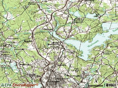
West Boylston, Massachusetts

Submit your own pictures of this town and show them to the world
- OSM Map
- General Map
- Google Map
- MSN Map

Population change since 2000: +2.5%
 |
| Males: 4,246 | |
| Females: 3,423 |
| Median resident age: | 45.6 years |
| Massachusetts median age: | 39.2 years |
Zip codes: 01583.
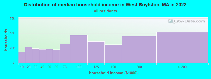
| West Boylston: | $96,894 |
| MA: | $94,488 |
Estimated per capita income in 2022: $44,648 (it was $22,899 in 2000)
West Boylston town income, earnings, and wages data
Estimated median house or condo value in 2022: $428,320 (it was $155,100 in 2000)
| West Boylston: | $428,320 |
| MA: | $534,700 |
Mean prices in 2022: all housing units: $419,164; detached houses: $447,621; townhouses or other attached units: $343,592; in 2-unit structures: $323,295; in 3-to-4-unit structures: $332,295; in 5-or-more-unit structures: $232,758; mobile homes: $113,885
Detailed information about poverty and poor residents in West Boylston, MA


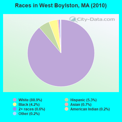
- 6,81788.9%White alone
- 4045.3%Hispanic
- 3214.2%Black alone
- 520.7%Asian alone
- 430.6%Two or more races
- 170.2%American Indian alone
- 130.2%Other race alone
- 20.03%Native Hawaiian and Other
Pacific Islander alone
Races in West Boylston detailed stats: ancestries, foreign born residents, place of birth
According to our research of Massachusetts and other state lists, there was 1 registered sex offender living in West Boylston, Massachusetts as of May 07, 2024.
The ratio of all residents to sex offenders in West Boylston is 7,669 to 1.
The ratio of registered sex offenders to all residents in this city is much lower than the state average.
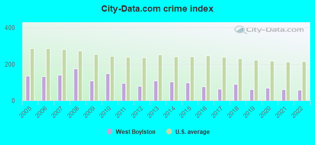
Type |
2009 |
2010 |
2011 |
2012 |
2013 |
2014 |
2015 |
2016 |
2017 |
2018 |
2019 |
2020 |
2021 |
2022 |
|---|---|---|---|---|---|---|---|---|---|---|---|---|---|---|
| Murders (per 100,000) | 0 (0.0) | 0 (0.0) | 0 (0.0) | 0 (0.0) | 0 (0.0) | 0 (0.0) | 0 (0.0) | 0 (0.0) | 0 (0.0) | 1 (12.3) | 0 (0.0) | 0 (0.0) | 0 (0.0) | 0 (0.0) |
| Rapes (per 100,000) | 0 (0.0) | 3 (39.1) | 1 (13.0) | 0 (0.0) | 4 (51.1) | 1 (12.5) | 3 (37.9) | 0 (0.0) | 1 (12.7) | 1 (12.3) | 0 (0.0) | 2 (24.8) | 2 (24.6) | 1 (12.7) |
| Robberies (per 100,000) | 3 (35.9) | 1 (13.0) | 0 (0.0) | 1 (12.9) | 0 (0.0) | 2 (25.1) | 1 (12.6) | 3 (38.0) | 1 (12.7) | 2 (24.7) | 2 (24.3) | 0 (0.0) | 0 (0.0) | 1 (12.7) |
| Assaults (per 100,000) | 6 (71.7) | 6 (78.2) | 0 (0.0) | 5 (64.4) | 1 (12.8) | 1 (12.5) | 1 (12.6) | 5 (63.3) | 7 (89.1) | 7 (86.4) | 9 (109.5) | 9 (111.5) | 9 (110.6) | 7 (88.9) |
| Burglaries (per 100,000) | 20 (239.1) | 32 (417.3) | 27 (349.9) | 25 (322.2) | 23 (294.1) | 38 (476.7) | 10 (126.4) | 13 (164.7) | 5 (63.6) | 7 (86.4) | 13 (158.2) | 5 (61.9) | 2 (24.6) | 5 (63.5) |
| Thefts (per 100,000) | 137 (1,638) | 116 (1,513) | 105 (1,361) | 76 (979.5) | 83 (1,061) | 96 (1,204) | 94 (1,188) | 73 (924.6) | 46 (585.5) | 46 (567.7) | 27 (328.6) | 31 (383.9) | 34 (417.8) | 25 (317.6) |
| Auto thefts (per 100,000) | 3 (35.9) | 8 (104.3) | 6 (77.8) | 1 (12.9) | 3 (38.4) | 1 (12.5) | 6 (75.8) | 3 (38.0) | 5 (63.6) | 3 (37.0) | 7 (85.2) | 6 (74.3) | 2 (24.6) | 9 (114.3) |
| Arson (per 100,000) | 0 (0.0) | 1 (13.0) | 0 (0.0) | 1 (12.9) | 0 (0.0) | 0 (0.0) | 0 (0.0) | 1 (12.7) | 0 (0.0) | 0 (0.0) | 0 (0.0) | 0 (0.0) | 1 (12.3) | 1 (12.7) |
| City-Data.com crime index | 110.2 | 148.9 | 95.5 | 79.5 | 109.6 | 102.6 | 99.1 | 75.6 | 64.8 | 91.0 | 60.2 | 67.7 | 62.2 | 58.1 |
The City-Data.com crime index weighs serious crimes and violent crimes more heavily. Higher means more crime, U.S. average is 246.1. It adjusts for the number of visitors and daily workers commuting into cities.
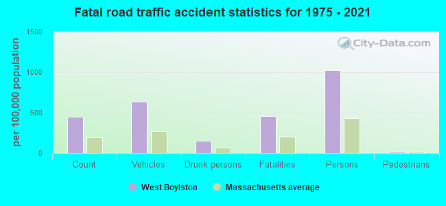
Crime rate in West Boylston detailed stats: murders, rapes, robberies, assaults, burglaries, thefts, arson
Full-time law enforcement employees in 2015, including police officers: 14 (13 officers - 13 male; 0 female).
| Officers per 1,000 residents here: | 1.64 |
| Massachusetts average: | 2.54 |
 Recent articles from our blog. Our writers, many of them Ph.D. graduates or candidates, create easy-to-read articles on a wide variety of topics.

 | Big MA Ancestry Data Thread by Town (31 replies) |
| Central or Western MA towns for Seniors (16 replies) |
| What Are the Cheapest and Most Expensive Single Family Home For Sale In Your Town? (50 replies) |
| Coronavirus in Massachusetts (18047 replies) |
| Moving Small Family to Worcester. Advice? (25 replies) |
| Under $250k any Massachusetts single family house with yard (117 replies) |
Latest news from West Boylston, MA collected exclusively by city-data.com from local newspapers, TV, and radio stations
Ancestries: Irish (20.1%), Italian (17.2%), English (14.3%), French (12.8%), Swedish (6.5%), Polish (5.9%).
Current Local Time: EST time zone
Incorporated in 1808
Elevation: 481 feet
Land area: 12.9 square miles.
Population density: 595 people per square mile (low).
171 residents are foreign born (1.1% Europe, 0.6% Asia).
| This town: | 2.3% |
| Massachusetts: | 12.2% |
| West Boylston town: | 1.6% ($2,537) |
| Massachusetts: | 1.3% ($2,336) |
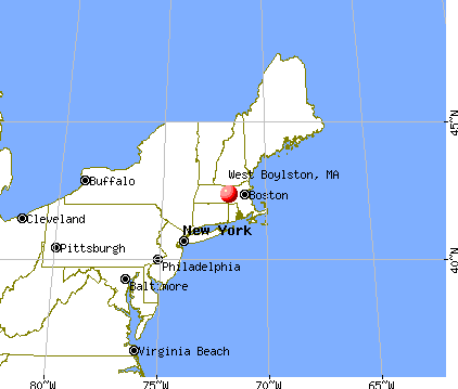
Nearest city with pop. 50,000+: Worcester, MA  (6.4 miles , pop. 172,648).
Nearest city with pop. 200,000+: Boston, MA (35.8 miles , pop. 589,141).
Nearest city with pop. 1,000,000+: Bronx, NY (150.3 miles , pop. 1,332,650).
Nearest cities:
), ), Latitude: 42.36 N, Longitude: 71.79 W
Area codes: 774, 508

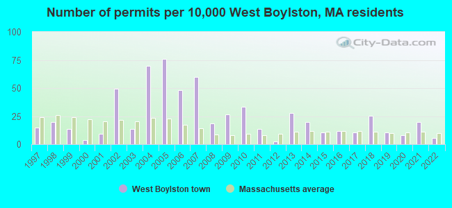
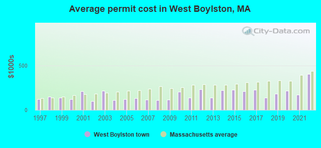
Single-family new house construction building permits:
- 2022: 4 buildings, average cost: $402,500
- 2021: 15 buildings, average cost: $168,900
- 2020: 6 buildings, average cost: $216,000
- 2019: 8 buildings, average cost: $183,800
- 2018: 19 buildings, average cost: $135,700
- 2017: 8 buildings, average cost: $224,600
- 2016: 9 buildings, average cost: $208,200
- 2015: 8 buildings, average cost: $229,100
- 2014: 15 buildings, average cost: $222,500
- 2013: 21 buildings, average cost: $138,100
- 2012: 2 buildings, average cost: $230,000
- 2011: 10 buildings, average cost: $139,600
- 2010: 25 buildings, average cost: $203,600
- 2009: 20 buildings, average cost: $116,800
- 2008: 14 buildings, average cost: $108,100
- 2007: 45 buildings, average cost: $115,000
- 2006: 36 buildings, average cost: $133,800
- 2005: 57 buildings, average cost: $122,500
- 2004: 52 buildings, average cost: $108,400
- 2003: 10 buildings, average cost: $217,700
- 2002: 37 buildings, average cost: $100,200
- 2001: 7 buildings, average cost: $211,900
- 2000: 3 buildings, average cost: $123,300
- 1999: 10 buildings, average cost: $136,100
- 1998: 15 buildings, average cost: $148,700
- 1997: 11 buildings, average cost: $122,600
| Here: | 3.7% |
| Massachusetts: | 3.5% |
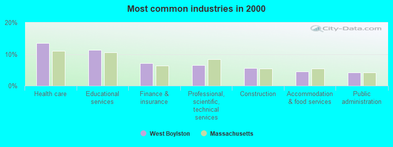
- Health care (13.5%)
- Educational services (11.3%)
- Finance & insurance (7.2%)
- Professional, scientific, technical services (6.6%)
- Construction (5.6%)
- Accommodation & food services (4.5%)
- Public administration (4.3%)
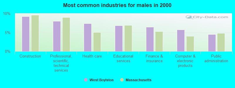
- Construction (9.2%)
- Professional, scientific, technical services (8.0%)
- Health care (7.4%)
- Educational services (6.8%)
- Finance & insurance (6.4%)
- Computer & electronic products (5.7%)
- Public administration (4.5%)
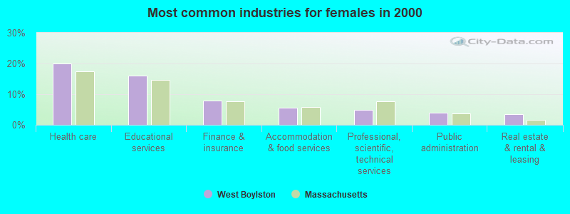
- Health care (20.1%)
- Educational services (16.0%)
- Finance & insurance (8.0%)
- Accommodation & food services (5.5%)
- Professional, scientific, technical services (5.0%)
- Public administration (4.0%)
- Real estate & rental & leasing (3.6%)
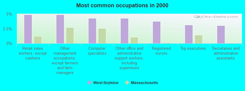
- Retail sales workers, except cashiers (4.9%)
- Other management occupations, except farmers and farm managers (4.9%)
- Computer specialists (4.3%)
- Other office and administrative support workers, including supervisors (4.3%)
- Registered nurses (3.7%)
- Top executives (3.1%)
- Secretaries and administrative assistants (3.1%)
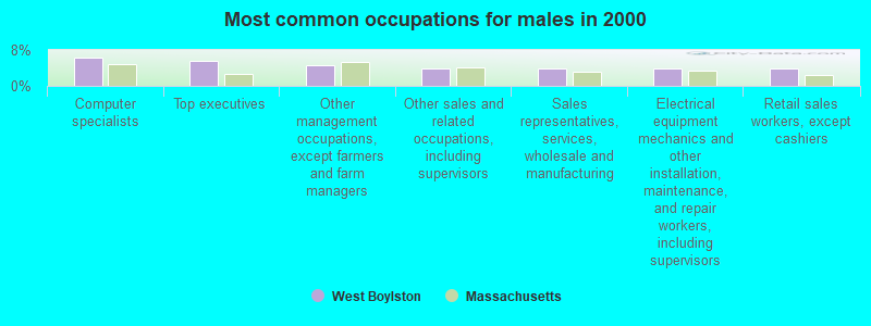
- Computer specialists (6.3%)
- Top executives (5.7%)
- Other management occupations, except farmers and farm managers (4.7%)
- Other sales and related occupations, including supervisors (3.9%)
- Sales representatives, services, wholesale and manufacturing (3.8%)
- Electrical equipment mechanics and other installation, maintenance, and repair workers, including supervisors (3.8%)
- Retail sales workers, except cashiers (3.8%)

- Registered nurses (7.0%)
- Secretaries and administrative assistants (6.4%)
- Other office and administrative support workers, including supervisors (6.2%)
- Retail sales workers, except cashiers (6.1%)
- Preschool, kindergarten, elementary, and middle school teachers (5.8%)
- Other management occupations, except farmers and farm managers (5.2%)
- Health technologists and technicians (3.8%)
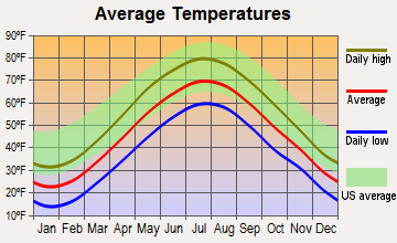
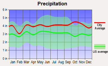
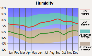
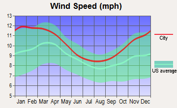
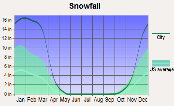
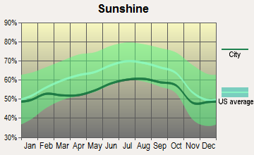
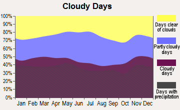
Average climate in West Boylston, Massachusetts
Based on data reported by over 4,000 weather stations
(lower is better)
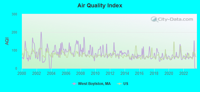
Air Quality Index (AQI) level in 2022 was 64.6. This is about average.
| City: | 64.6 |
| U.S.: | 72.6 |
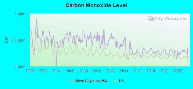
Carbon Monoxide (CO) [ppm] level in 2022 was 0.259. This is about average. Closest monitor was 6.4 miles away from the city center.
| City: | 0.259 |
| U.S.: | 0.251 |
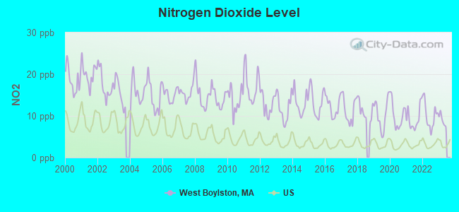
Nitrogen Dioxide (NO2) [ppb] level in 2022 was 10.1. This is significantly worse than average. Closest monitor was 6.0 miles away from the city center.
| City: | 10.1 |
| U.S.: | 5.1 |
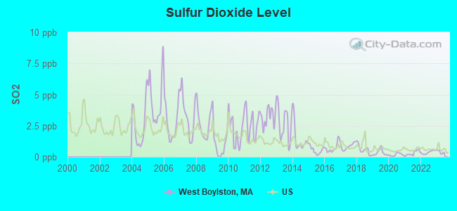
Sulfur Dioxide (SO2) [ppb] level in 2022 was 0.370. This is significantly better than average. Closest monitor was 6.0 miles away from the city center.
| City: | 0.370 |
| U.S.: | 1.515 |
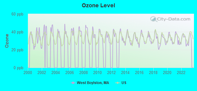
Ozone [ppb] level in 2022 was 31.8. This is about average. Closest monitor was 6.0 miles away from the city center.
| City: | 31.8 |
| U.S.: | 33.3 |
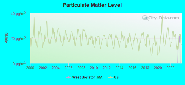
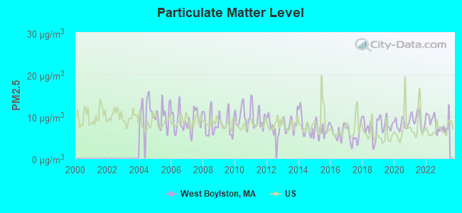
Particulate Matter (PM2.5) [µg/m3] level in 2022 was 8.71. This is about average. Closest monitor was 6.6 miles away from the city center.
| City: | 8.71 |
| U.S.: | 8.11 |
Tornado activity:
West Boylston-area historical tornado activity is slightly above Massachusetts state average. It is 19% smaller than the overall U.S. average.
On 6/9/1953, a category F4 (max. wind speeds 207-260 mph) tornado 14.3 miles away from the West Boylston town center killed 90 people and injured 1228 people and caused between $50,000,000 and $500,000,000 in damages.
On 6/9/1953, a category F3 (max. wind speeds 158-206 mph) tornado 13.2 miles away from the town center injured 17 people and caused between $500,000 and $5,000,000 in damages.
Earthquake activity:
West Boylston-area historical earthquake activity is significantly above Massachusetts state average. It is 71% smaller than the overall U.S. average.On 10/7/1983 at 10:18:46, a magnitude 5.3 (5.1 MB, 5.3 LG, 5.1 ML, Class: Moderate, Intensity: VI - VII) earthquake occurred 169.6 miles away from the city center
On 4/20/2002 at 10:50:47, a magnitude 5.3 (5.3 ML, Depth: 3.0 mi) earthquake occurred 177.1 miles away from West Boylston center
On 4/20/2002 at 10:50:47, a magnitude 5.2 (5.2 MB, 4.2 MS, 5.2 MW, 5.0 MW) earthquake occurred 176.2 miles away from the city center
On 1/19/1982 at 00:14:42, a magnitude 4.7 (4.5 MB, 4.7 MD, 4.5 LG, Class: Light, Intensity: IV - V) earthquake occurred 79.4 miles away from West Boylston center
On 10/16/2012 at 23:12:25, a magnitude 4.7 (4.7 ML, Depth: 10.0 mi) earthquake occurred 103.0 miles away from the city center
On 8/22/1992 at 12:20:32, a magnitude 4.8 (4.8 MB, 3.8 MS, 4.7 LG, Depth: 6.2 mi) earthquake occurred 237.8 miles away from the city center
Magnitude types: regional Lg-wave magnitude (LG), body-wave magnitude (MB), duration magnitude (MD), local magnitude (ML), surface-wave magnitude (MS), moment magnitude (MW)
Natural disasters:
The number of natural disasters in Worcester County (27) is a lot greater than the US average (15).Major Disasters (Presidential) Declared: 15
Emergencies Declared: 12
Causes of natural disasters: Floods: 9, Storms: 8, Hurricanes: 6, Snowstorms: 5, Winter Storms: 4, Blizzards: 2, Snows: 2, Fire: 1, Heavy Rain: 1, Snowfall: 1, Tornado: 1, Wind: 1 (Note: some incidents may be assigned to more than one category).
Hospitals and medical centers in West Boylston:
- OAKDALE NURSING HOME (86 N MAIN ST)
- OAKDALE REHABILITATION AND SKILLED NURSING CENTER (76 NORTH MAIN STREET)
Other hospitals and medical centers near West Boylston:
- KNOLLWOOD NURSING CENTER (Nursing Home, about 3 miles away; WORCESTER, MA)
- STERLING VILLAGE (Nursing Home, about 4 miles away; STERLING, MA)
- HOLDEN NURSING HOME (Nursing Home, about 4 miles away; HOLDEN, MA)
- HOLDEN REHABILITATION AND SKILLED NURSING CENTER INC (Nursing Home, about 4 miles away; HOLDEN, MA)
- WACHUSETT EXTENDED CARE FACILITY (Nursing Home, about 4 miles away; HOLDEN, MA)
- MEDICAL CTR OF CENTRAL MASS-HOLDEN (Hospital, about 4 miles away; HOLDEN, MA)
- WAYSIDE CENTER (Nursing Home, about 5 miles away; WORCESTER, MA)
Amtrak stations near West Boylston:
- 7 miles: WORCESTER (WORCHESTER, 45 SHREWSBURY ST.) . Services: ticket office, fully wheelchair accessible, enclosed waiting area, public restrooms, public payphones, vending machines, free short-term parking, free long-term parking, call for taxi service, public transit connection.
- 20 miles: FRAMINGHAM (443 WAVERLY ST.) . Services: public payphones, snack bar, paid short-term parking, taxi stand, public transit connection.
College/University in West Boylston:
Colleges/universities with over 2000 students nearest to West Boylston:
- Quinsigamond Community College (about 4 miles; Worcester, MA; Full-time enrollment: 5,877)
- Assumption College (about 5 miles; Worcester, MA; FT enrollment: 2,580)
- Worcester Polytechnic Institute (about 6 miles; Worcester, MA; FT enrollment: 3,930)
- Worcester State University (about 8 miles; Worcester, MA; FT enrollment: 5,426)
- Clark University (about 8 miles; Worcester, MA; FT enrollment: 3,687)
- College of the Holy Cross (about 9 miles; Worcester, MA; FT enrollment: 3,125)
- Fitchburg State University (about 16 miles; Fitchburg, MA; FT enrollment: 5,010)
Public high school in West Boylston:
- WEST BOYLSTON JUNIOR/SENIOR HIGH (Students: 651, Location: 125 CRESCENT STREET, Grades: 6-12)
Public elementary/middle school in West Boylston:
- MAJOR EDWARDS ELEMENTARY (Students: 471, Location: 70 CRESCENT STREET, Grades: PK-5)
Library in West Boylston:
Points of interest:
Notable locations in West Boylston: Wachusett Country Club (A), West Boylston Fire Department (B), Beaman Memorial Public Library (C), Worcester County Jail and House of Corrections Library (D), Worcester County Jail and House of Corrections (E). Display/hide their locations on the map
Shopping Center: Meadowbrook Shopping Center (1). Display/hide its location on the map
Churches in West Boylston include: Our Lady of Good Counsel Church (A), First Congregational Church (B), Christ Lutheran Church (C), Bethlehem Baptist Church (D). Display/hide their locations on the map
Cemeteries: High Plain Cemetery (1), Legge Cemetery (2), Saint Lukes Cemetery (3). Display/hide their locations on the map
Lakes: Lily Ponds (A), Carrolls Pond (B), Edwards Pond (C). Display/hide their locations on the map
Streams, rivers, and creeks: Stillwater River (A), Quinapoxet River (B), Muddy Brook (C), Gates Brook (D), Malden Brook (E), Scarletts Brook (F), Waushacum Brook (G), West Boylston Brook (H). Display/hide their locations on the map
Park in West Boylston: Goodale Park (1). Display/hide its location on the map
Tourist attraction: Aquarium Center (Cultural Attractions- Events- & Facilities; 287 W. Boylston St.).
Hotels: ABC Printing (175 West Boylston Street), Classic Suites & Inns (181 West Boylston Street), Rose Cottage Bed & Breakfast (24 Worcester Street), SONA Motor Inn (175 West Boylston Street).
Birthplace of: Edwin Holmes (inventor) - Inventor, Erastus Brigham Bigelow - Inventor, Bruce Marshall (ice hockey) - Ice hockey coach, Charlie Baker (baseball) - Baseball player.
Drinking water stations with addresses in West Boylston and their reported violations in the past:
WEST BOYLSTON WATER DISTRICT (Population served: 6,242, Purch surface water):Past health violations:Past monitoring violations:
- MCL, Monthly (TCR) - In JUL-2010, Contaminant: Coliform. Follow-up actions: St AO (w/o penalty) issued (SEP-08-2010), St Compliance achieved (SEP-08-2010)
- MCL, Monthly (TCR) - In OCT-2009, Contaminant: Coliform. Follow-up actions: St AO (w/o penalty) issued (DEC-23-2009), St Compliance achieved (DEC-23-2009)
- MCL, Monthly (TCR) - In SEP-2008, Contaminant: Coliform. Follow-up actions: St AO (w/o penalty) issued (NOV-05-2008), St Compliance achieved (NOV-05-2008)
- MCL, Monthly (TCR) - In OCT-2007, Contaminant: Coliform. Follow-up actions: St AO (w/o penalty) issued (NOV-19-2007), St Compliance achieved (NOV-19-2007)
- MCL, Monthly (TCR) - In AUG-2007, Contaminant: Coliform. Follow-up actions: St AO (w/o penalty) issued (SEP-27-2007)
- Monitoring, Repeat Major (TCR) - In AUG-2007, Contaminant: Coliform (TCR). Follow-up actions: St AO (w/o penalty) issued (SEP-27-2007)
- One minor monitoring violation
| This town: | 2.4 people |
| Massachusetts: | 2.5 people |
| This town: | 69.5% |
| Whole state: | 63.0% |
| This town: | 5.2% |
| Whole state: | 7.0% |
Likely homosexual households (counted as self-reported same-sex unmarried-partner households)
- Lesbian couples: 0.3% of all households
- Gay men: 0.1% of all households
| This town: | 3.2% |
| Whole state: | 9.3% |
| This town: | 0.8% |
| Whole state: | 4.4% |
People in group quarters in West Boylston in 2010:
- 1,138 people in local jails and other municipal confinement facilities
- 162 people in nursing facilities/skilled-nursing facilities
- 4 people in group homes intended for adults
- 4 people in residential treatment centers for adults
People in group quarters in West Boylston in 2000:
- 1,220 people in local jails and other confinement facilities (including police lockups)
- 78 people in nursing homes
- 9 people in other noninstitutional group quarters
Banks with branches in West Boylston (2011 data):
- Commerce Bank & Trust Company: West Boylston Branch at 320 West Boylston Street, branch established on 1997/09/15. Info updated 2006/10/06: Bank assets: $1,410.8 mil, Deposits: $1,187.6 mil, headquarters in Worcester, MA, positive income, Commercial Lending Specialization, 14 total offices, Holding Company: Commerce Bancshares Corp.
- Clinton Savings Bank: West Boylston Branch at 231 West Boylston Street, branch established on 2000/08/07. Info updated 2012/04/03: Bank assets: $479.5 mil, Deposits: $362.7 mil, headquarters in Clinton, MA, positive income, Mortgage Lending Specialization, 7 total offices, Holding Company: Clinton Financial Services, Mhc
- Sovereign Bank, National Association: West Boylston Branch at 240 West Boylston Street, branch established on 1965/12/28. Info updated 2012/01/31: Bank assets: $78,146.9 mil, Deposits: $48,042.9 mil, headquarters in Wilmington, DE, positive income, Commercial Lending Specialization, 718 total offices, Holding Company: Banco Santander, S.A.
- United Bank: West Boylston Branch at 26 West Boylston Street, branch established on 2007/06/30. Info updated 2012/01/20: Bank assets: $1,617.9 mil, Deposits: $1,235.2 mil, headquarters in West Springfield, MA, positive income, Commercial Lending Specialization, 25 total offices
- Bank of America, National Association: Fair Plaza Branch at Route 12, branch established on 1974/04/01. Info updated 2009/11/18: Bank assets: $1,451,969.3 mil, Deposits: $1,077,176.8 mil, headquarters in Charlotte, NC, positive income, 5782 total offices, Holding Company: Bank Of America Corporation
For population 15 years and over in West Boylston:
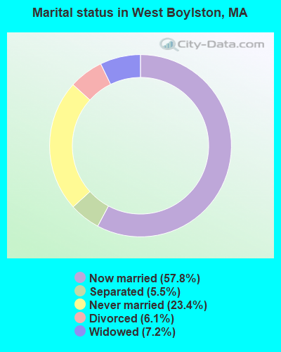
- Never married: 23.4%
- Now married: 57.8%
- Separated: 5.5%
- Widowed: 7.2%
- Divorced: 6.1%
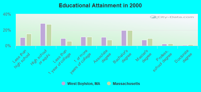
For population 25 years and over in West Boylston:
- High school or higher: 89.4%
- Bachelor's degree or higher: 29.6%
- Graduate or professional degree: 10.3%
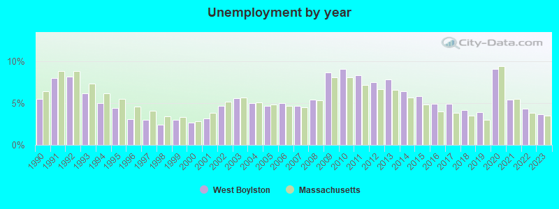
- Unemployed: 2.9%
- Mean travel time to work (commute): 23.0 minutes
| Here: | 10.6 |
| Massachusetts average: | 13.1 |


Graphs represent county-level data. Detailed 2008 Election Results
Religion statistics for West Boylston, MA (based on Worcester County data)


| Religion | Adherents | Congregations |
|---|---|---|
| Catholic | 306,925 | 118 |
| Mainline Protestant | 43,326 | 171 |
| Evangelical Protestant | 37,511 | 203 |
| Other | 18,931 | 69 |
| Orthodox | 7,935 | 15 |
| Black Protestant | 497 | 6 |
| None | 383,427 | - |
Food Environment Statistics:
| This county: | 1.73 / 10,000 pop. |
| Massachusetts: | 1.98 / 10,000 pop. |
| Worcester County: | 0.05 / 10,000 pop. |
| Massachusetts: | 0.05 / 10,000 pop. |
| Here: | 1.79 / 10,000 pop. |
| State: | 2.22 / 10,000 pop. |
| Worcester County: | 2.22 / 10,000 pop. |
| State: | 1.77 / 10,000 pop. |
| Worcester County: | 7.27 / 10,000 pop. |
| State: | 8.76 / 10,000 pop. |
| Worcester County: | 8.0% |
| Massachusetts: | 8.1% |
| Here: | 24.0% |
| Massachusetts: | 22.5% |
| Worcester County: | 16.6% |
| State: | 16.5% |
4.71% of this county's 2021 resident taxpayers lived in other counties in 2020 ($76,229 average adjusted gross income)
| Here: | 4.71% |
| Massachusetts average: | 6.35% |
0.02% of residents moved from foreign countries ($100 average AGI)
Worcester County: 0.02% Massachusetts average: 0.01%
Top counties from which taxpayers relocated into this county between 2020 and 2021:
| from Middlesex County, MA | |
| from Norfolk County, MA | |
| from Suffolk County, MA |
4.84% of this county's 2020 resident taxpayers moved to other counties in 2021 ($87,252 average adjusted gross income)
| Here: | 4.84% |
| Massachusetts average: | 7.18% |
0.03% of residents moved to foreign countries ($199 average AGI)
Worcester County: 0.03% Massachusetts average: 0.02%
Top counties to which taxpayers relocated from this county between 2020 and 2021:
| to Middlesex County, MA | |
| to Norfolk County, MA | |
| to Suffolk County, MA |
| Businesses in West Boylston, MA | ||||
| Name | Count | Name | Count | |
|---|---|---|---|---|
| Ace Hardware | 1 | GameStop | 1 | |
| CVS | 1 | Payless | 1 | |
| Dairy Queen | 1 | Subway | 1 | |
| Dunkin Donuts | 1 | T-Mobile | 1 | |
| FedEx | 2 | Walmart | 1 | |
Strongest AM radio stations in West Boylston:
- WTAG (580 AM; 5 kW; WORCESTER, MA; Owner: CAPSTAR TX LIMITED PARTNERSHIP)
- WCRN (830 AM; 50 kW; WORCESTER, MA; Owner: CARTER BROADCASTING CORPORATION)
- WKOX (1200 AM; 50 kW; FRAMINGHAM, MA; Owner: CAPSTAR TX LIMITED PARTNERSHIP)
- WVNE (760 AM; daytime; 25 kW; LEICESTER, MA; Owner: BLOUNT MASSCOM, INC.)
- WVEI (1440 AM; 5 kW; WORCESTER, MA; Owner: ENTERCOM BOSTON LICENSE, LLC)
- WBIX (1060 AM; 40 kW; NATICK, MA; Owner: LANGER BROADCASTING CORPORATION)
- WEEI (850 AM; 50 kW; BOSTON, MA; Owner: ENTERCOM BOSTON LICENSE, LLC)
- WRKO (680 AM; 50 kW; BOSTON, MA; Owner: ENTERCOM BOSTON LICENSE, LLC)
- WAMG (890 AM; 25 kW; DEDHAM, MA; Owner: MEGA COMMUNICATIONS OF DEDHAM LICENSEE, LLC)
- WALE (990 AM; 50 kW; GREENVILLE, RI; Owner: NORTH AMERICAN BROADCASTING CO., INC.)
- WAZN (1470 AM; 7 kW; MARLBOROUGH, MA; Owner: MULTICULTURAL RADIO BROADCASTING, INC.)
- WORC (1310 AM; 5 kW; WORCESTER, MA; Owner: CHOWDER BROADCAST GROUP LLC)
- WWZN (1510 AM; 50 kW; BOSTON, MA; Owner: ROSE CITY RADIO CORPORATION)
Strongest FM radio stations in West Boylston:
- WAAF (107.3 FM; WORCESTER, MA; Owner: ENTERCOM BOSTON LICENSE, LLC)
- WSRS (96.1 FM; WORCESTER, MA; Owner: CAPSTAR TX LIMITED PARTNERSHIP)
- WXLO (104.5 FM; FITCHBURG, MA; Owner: CITADEL BROADCASTING COMPANY)
- WICN (90.5 FM; WORCESTER, MA; Owner: WICN PUBLIC RADIO, INC)
- WBMX (98.5 FM; BOSTON, MA; Owner: INFINITY RADIO OPERATIONS INC.)
- WJMN (94.5 FM; BOSTON, MA; Owner: AMFM RADIO LICENSES, L.L.C.)
- WCRB (102.5 FM; WALTHAM, MA; Owner: CHARLES RIVER BROADCASTING WCRB LICE)
- WTKK (96.9 FM; BOSTON, MA; Owner: GREATER BOSTON RADIO, INC.)
- WROR-FM (105.7 FM; FRAMINGHAM, MA; Owner: GREATER BOSTON RADIO, INC.)
- WBOS (92.9 FM; BROOKLINE, MA; Owner: GREATER BOSTON RADIO, INC.)
- WGBH (89.7 FM; BOSTON, MA; Owner: WGBH EDUCATIONAL FOUNDATION)
- WFEX (92.1 FM; PETERBOROUGH, NH; Owner: FNX BROADCASTING OF NEW HAMPSHIRE LLC)
- WBPR (91.9 FM; WORCESTER, MA; Owner: UNIVERSITY OF MASSACHUSETTS)
- WCUW (91.3 FM; WORCESTER, MA; Owner: WUW, INC.)
- WBUR-FM (90.9 FM; BOSTON, MA; Owner: TRUSTEES OF BOSTON UNIVERSITY)
- WXKS-FM (107.9 FM; MEDFORD, MA; Owner: AMFM RADIO LICENSES, L.L.C.)
- WODS (103.3 FM; BOSTON, MA; Owner: INFINITY BROADCASTING OPERATIONS, INC.)
- WMJX (106.7 FM; BOSTON, MA; Owner: GREATER BOSTON RADIO, INC.)
- WFCR (88.5 FM; AMHERST, MA; Owner: UNIVERSITY OF MASSACHUSETTS)
- WYCM (90.1 FM; CHARLTON, MA; Owner: BAY PATH VOCATIONAL HIGH SCHOOL)
TV broadcast stations around West Boylston:
- WUNI (Channel 27; WORCESTER, MA; Owner: ENTRAVISION HOLDINGS, LLC)
- WUTF (Channel 66; MARLBOROUGH, MA; Owner: TELEFUTURA BOSTON LLC)
- WCVB-TV (Channel 5; BOSTON, MA; Owner: WCVB HEARST-ARGYLE TV, INC.)
- WGBH-TV (Channel 2; BOSTON, MA; Owner: WGBH EDUCATIONAL FOUNDATION)
- WHDH-TV (Channel 7; BOSTON, MA; Owner: WHDH-TV)
- WMFP (Channel 62; LAWRENCE, MA; Owner: WSAH LICENSE, INC.)
- WYDN (Channel 48; WORCESTER, MA; Owner: EDUCATIONAL PUBLIC TV CORPORATION)
- WBZ-TV (Channel 4; BOSTON, MA; Owner: VIACOM INC.)
- WGBX-TV (Channel 44; BOSTON, MA; Owner: WGBH EDUCATIONAL FOUNDATION)
- WSBK-TV (Channel 38; BOSTON, MA; Owner: VIACOM INC.)
- WLVI-TV (Channel 56; CAMBRIDGE, MA; Owner: WLVI, INC.)
- WCRN-LP (Channel 34; LEICESTER, MA; Owner: CARTER BROADCASTING CORPORATION)
- WFXT (Channel 25; BOSTON, MA; Owner: FOX TELEVISION STATIONS INC.)
- W40BO (Channel 40; BOSTON, MA; Owner: PAXSON COMMUNICATIONS LPTV, INC.)
- WBPX (Channel 68; BOSTON, MA; Owner: PAXSON BOSTON-68 LICENSE, INC.)
- WPXQ (Channel 69; BLOCK ISLAND, RI; Owner: OCEAN STATE TELEVISION, L.L.C.)
- WTMU-LP (Channel 32; BOSTON, MA; Owner: ZGS BOSTON, INC.)
- WCEA-LP (Channel 58; BOSTON, MA; Owner: CHANNEL 19 TV CORPORATION)
- WNAC-TV (Channel 64; PROVIDENCE, RI; Owner: WNAC, LLC)
- WWDP (Channel 46; NORWELL, MA; Owner: NORWELL TELEVISION, LLC)
- WPRI-TV (Channel 12; PROVIDENCE, RI; Owner: TVL BROADCASTING OF RHODE ISLAND, LLC)
- WFXZ-CA (Channel 24; BOSTON, MA; Owner: BOSTON BROADCASTING CORP.)
- National Bridge Inventory (NBI) Statistics
- 17Number of bridges
- 164ft / 50.0mTotal length
- $42,153,000Total costs
- 216,925Total average daily traffic
- 18,907Total average daily truck traffic
- 474,102Total future (year 2031) average daily traffic
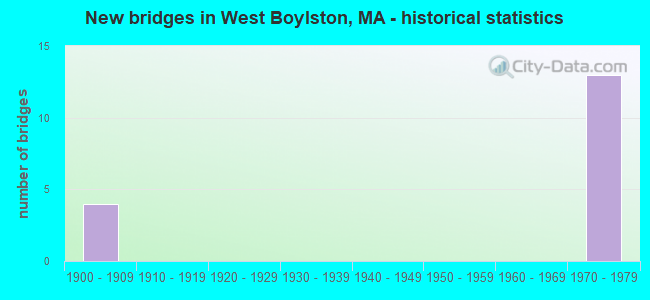
- New bridges - historical statistics
- 41900-1909
- 131970-1979
FCC Registered Antenna Towers:
5- Richard Byrne, Off Berman Street At Cutting Street (Lat: 42.385444 Lon: -71.784583), Type: 35.0, Overall height: 32.4 m, Registrant: Towerco Assets LLC, Afry@towerco.Com, , Cary, Phone: (919) 653-5710
- Richard Byrne, Off Berman Street At Cutting Street (Lat: 42.385444 Lon: -71.784583), Type: 35.0, Overall height: 32.4 m, Registrant: Towerco Assets LLC, Afry@towerco.Com, , Cary, Phone: (919) 653-5710
- Edward G Roach, Off Berman Street At Cutting Street (Lat: 42.385444 Lon: -71.784583), Type: 35.0, Structure height: 25027 m, Overall height: 32.4 m, Registrant: Sba 2012 Tc Assets, LLC, Eroach@sbasite.Com, , Boca -Raton, Phone: (561) 995-7670
- Edward G Roach, 208 Beaman Street (Lat: 42.385444 Lon: -71.784583), Type: 33.5, Structure height: 25027 m, Overall height: 32 m, Licensee ID: L, Registrant: Sba 2012 Tc Assets, LLC, Eroach@sbasite.Com, , Boca -Raton, Phone: (561) 995-7670
- Edward G Roach, 208 Beaman Street (Lat: 42.385444 Lon: -71.784583), Type: 33.5, Structure height: 25027 m, Overall height: 32 m, Registrant: Sba 2012 Tc Assets, LLC, Eroach@sbasite.Com, , Boca -Raton, Phone: (561) 995-7670
FCC Registered Broadcast Land Mobile Towers:
10 (See the full list of FCC Registered Broadcast Land Mobile Towers in West Boylston, MA)FCC Registered Microwave Towers:
3- W Boylston, Lawrence Street (Lat: 42.346472 Lon: -71.793389), Type: Pole, Structure height: 30.5 m, Call Sign: WQEI949,
Assigned Frequencies: 10637.5 MHz, Grant Date: 02/07/2006, Expiration Date: 02/07/2016, Cancellation Date: 02/18/2014, Certifier: Richard A Craig, Registrant: Verizon Wireless, 1120 Sanctuary Pkwy, #150 Gasa5reg, Alpharetta, GA 30009-7630, Phone: (770) 797-1070, Fax: (770) 797-1036, Email:
- BOS1126, Lawrence Street (Lat: 42.346722 Lon: -71.794056), Type: Pole, Structure height: 30.5 m, Call Sign: WQFG745, Licensee ID: L01728370,
Assigned Frequencies: 10795.0 MHz, 10835.0 MHz, 10755.0 MHz, Grant Date: 07/11/2006, Expiration Date: 07/11/2016, Cancellation Date: 09/09/2013, Certifier: Joseph M Sandri Jr., Registrant: Fibertower Network Services, Corp., Debtor-In-Possession, 1875 Eye Street, Nw, 5th Floor, Room 505, Washington, DC 20006, Phone: (202) 223-1028, Email:
- BS33XC133, Off Berman Street At Cutting Street (Lat: 42.385444 Lon: -71.784583), Type: Ltower, Structure height: 32.4 m, Overall height: 35 m, Call Sign: WQPU388,
Assigned Frequencies: 10935.0 MHz, 10935.0 MHz, 10935.0 MHz, Grant Date: 10/05/2022, Expiration Date: 08/16/2032, Cancellation Date: 05/16/2023, Certifier: David Werblow, Registrant: T-Mobile Usa, Inc., 12920 Se 38th Street, Bellevue, WA 98006, Phone: (425) 383-8401, Email:
FCC Registered Amateur Radio Licenses:
35 (See the full list of FCC Registered Amateur Radio Licenses in West Boylston)FAA Registered Aircraft:
7- Aircraft: CESSNA 177 (Category: Land, Seats: 4, Weight: Up to 12,499 Pounds, Speed: 108 mph), Engine: LYCOMING 0-320 SERIES (180 HP) (Reciprocating)
N-Number: 2823X, N2823X, N-2823X, Serial Number: 17700223, Airworthiness Date: 10/31/1967, Certificate Issue Date: 04/19/2019
Registrant (Corporation): Spectron Aviation Inc, 166 Fairbanks St, West Boylston, MA 01583
Deregistered: Cancel Date: 05/28/2013, Exported to: Canada - Aircraft: CESSNA 177 (Category: Land, Seats: 4, Weight: Up to 12,499 Pounds, Speed: 108 mph), Engine: LYCOMING 0-320 SERIES (180 HP) (Reciprocating)
N-Number: 3408T, N3408T, N-3408T, Serial Number: 17700708, Airworthiness Date: 01/18/1968, Certificate Issue Date: 04/19/2019
Registrant (Corporation): Spectron Aviation Inc, 166 Fairbanks St, West Boylston, MA 01583 - Aircraft: BEECH N35 (Category: Land, Seats: 5, Weight: Up to 12,499 Pounds, Speed: 150 mph), Engine: CONT MOTOR I0-470 SERIES (260 HP) (Reciprocating)
N-Number: 345BC, N345BC, N-345BC, Serial Number: D-6567, Year manufactured: 1960, Airworthiness Date: 11/14/1960, Certificate Issue Date: 09/03/2019
Registrant (Individual): Dominic P Scalera, 535 Prospect St, West Boylston, MA 01583 - Aircraft: GAMMON RICHARD J MERLIN (Category: Amphibian, Seats: 2, Weight: Up to 12,499 Pounds), Engine: BOMBARDIER ROTAX (ALL) (Reciprocating)
N-Number: 618CG, N618CG, N-618CG, Serial Number: MGT001, Year manufactured: 1998, Airworthiness Date: 06/10/1999, Certificate Issue Date: 04/19/2019
Registrant (Corporation): Spectron Aviation Inc, 166 Fairbanks St, West Boylston, MA 01583 - Aircraft: CESSNA 182Q (Category: Land, Seats: 4, Weight: Up to 12,499 Pounds, Speed: 112 mph), Engine: CONT MOTOR O-470 SERIES (230 HP) (Reciprocating)
N-Number: 759TP, N759TP, N-759TP, Serial Number: 18266249, Airworthiness Date: 02/03/1978, Certificate Issue Date: 12/11/2020
Registrant (Individual): William S Jr Italiano, Po Box 200, West Boylston, MA 01583 - Aircraft: MARTIN HP-14 (Category: Land, Weight: Up to 12,499 Pounds, Speed: 60 mph), Engine: None
N-Number: 8041, N8041, N-8041, Serial Number: 72, Year manufactured: 1968, Airworthiness Date: 10/27/1977, Certificate Issue Date: 06/11/2003
Registrant (Individual): John H Macnicol, 129 Pierce St, West Boylston, MA 01583 - Aircraft: CESSNA 172L (Category: Land, Seats: 4, Weight: Up to 12,499 Pounds, Speed: 105 mph), Engine: LYCOMING 0-320 SERIES (180 HP) (Reciprocating)
N-Number: 901MP, N901MP, N-901MP, Serial Number: 17259565, Airworthiness Date: 11/12/1970, Certificate Issue Date: 04/28/2016
Registrant (Individual): Phillip P Shubert, 167 Laurel St, West Boylston, MA 01583
Deregistered: Cancel Date: 09/06/2019
2002 - 2018 National Fire Incident Reporting System (NFIRS) incidents
- Fire incident types reported to NFIRS in West Boylston, MA
- 14537.1%Structure Fires
- 14035.8%Outside Fires
- 7719.7%Mobile Property/Vehicle Fires
- 297.4%Other
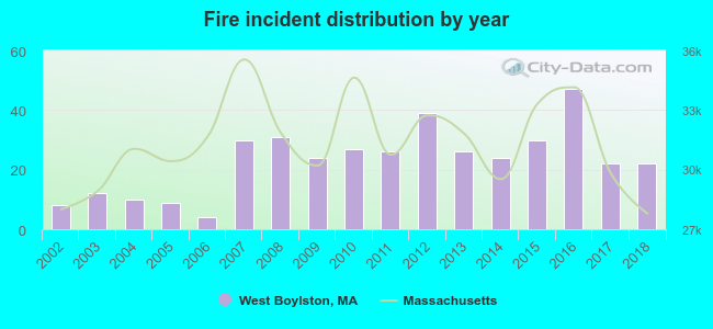 Based on the data from the years 2002 - 2018 the average number of fires per year is 23. The highest number of reported fires - 47 took place in 2016, and the least - 4 in 2006. The data has a growing trend.
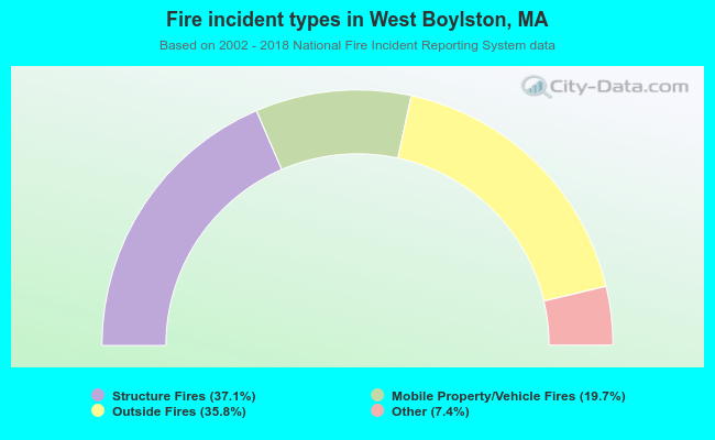 When looking into fire subcategories, the most incidents belonged to: Structure Fires (37.1%), and Outside Fires (35.8%).
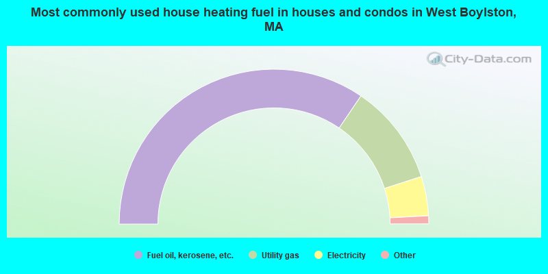
- 69.0%Fuel oil, kerosene, etc.
- 21.1%Utility gas
- 8.2%Electricity
- 1.5%Wood
- 0.3%Bottled, tank, or LP gas
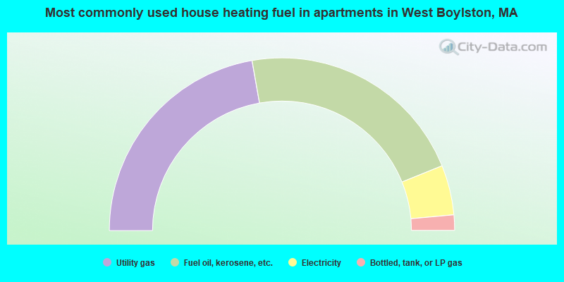
- 44.4%Utility gas
- 43.3%Fuel oil, kerosene, etc.
- 9.3%Electricity
- 2.9%Bottled, tank, or LP gas
West Boylston compared to Massachusetts state average:
- Unemployed percentage significantly below state average.
- Hispanic race population percentage below state average.
- Median age above state average.
- Foreign-born population percentage significantly below state average.
- Renting percentage below state average.
- Length of stay since moving in significantly above state average.
- Number of rooms per house significantly below state average.
- House age significantly below state average.
- Institutionalized population percentage significantly above state average.
West Boylston on our top lists:
- #9 on the list of "Top 101 cities with largest percentage of females in occupations: life and physical scientists (population 5,000+)"
- #13 on the list of "Top 101 cities with largest percentage of females in occupations: air transportation workers (population 5,000+)"
- #17 on the list of "Top 101 cities with the largest percentage of people in local jails and other confinement facilities (including police lockups) (population 1,000+)"
- #32 on the list of "Top 101 cities with largest percentage of males in industries: paper and paper products merchant wholesalers (population 5,000+)"
- #36 on the list of "Top 101 cities with largest percentage of males in industries: fuel dealers (population 5,000+)"
- #37 on the list of "Top 101 cities with largest percentage of males in occupations: personal appearance workers (population 5,000+)"
- #38 on the list of "Top 101 cities with largest percentage of females in occupations: secondary school teachers (population 5,000+)"
- #42 on the list of "Top 101 cities with largest percentage of females in industries: electrical and electronic goods merchant wholesalers (population 5,000+)"
- #56 on the list of "Top 101 cities with largest percentage of males in occupations: physicians and surgeons (population 5,000+)"
- #59 on the list of "Top 101 cities with largest percentage of males in industries: health and personal care, except drug, stores (population 5,000+)"
- #60 on the list of "Top 101 cities with largest percentage of females in occupations: retail sales workers except cashiers (population 5,000+)"
- #71 on the list of "Top 101 cities with largest percentage of males in industries: personal and laundry services (population 5,000+)"
- #75 on the list of "Top 101 cities with largest percentage of males in industries: nonmetallic mineral products (population 5,000+)"
- #84 on the list of "Top 101 cities with largest percentage of males in industries: jewelry, luggage, and leather goods stores (population 5,000+)"
- #90 on the list of "Top 101 cities with largest percentage of females in industries: used merchandise, gift, novelty, and souvenir, and other miscellaneous stores (population 5,000+)"
- #91 on the list of "Top 101 cities with largest percentage of males in industries: health care (population 5,000+)"
- #95 on the list of "Top 101 cities with largest percentage of males in industries: furniture and home furnishings, and household appliance stores (population 5,000+)"
- #4 on the list of "Top 101 counties with the highest carbon monoxide air pollution readings in 2012 (ppm)"
- #5 on the list of "Top 101 counties with the most Catholic congregations"
- #12 on the list of "Top 101 counties with the highest surface withdrawal of fresh water for public supply"
- #16 on the list of "Top 101 counties with the highest total withdrawal of fresh water for public supply"
- #23 on the list of "Top 101 counties with the highest Sulfur Oxides Annual air pollution readings in 2012 (µg/m3)"

|
|
Total of 101 patent applications in 2008-2024.