Holden, Massachusetts
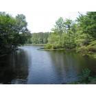
Holden: Holden_Pond_Summer
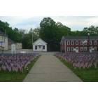
Holden: Field of Flags at Holden's First Baptist Church

Holden: Holden_Pond_Autumn
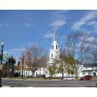
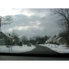
Holden: Holden_Town
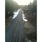
Holden: Looking west from Salisbury Street bridge
Holden: holden houses
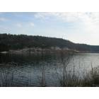
Holden: reservor lake
- add
your
Submit your own pictures of this town and show them to the world
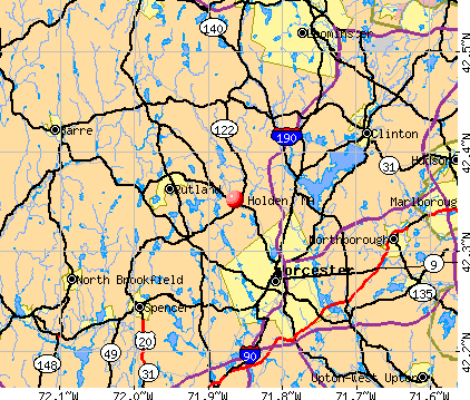
- OSM Map
- General Map
- Google Map
- MSN Map
Population change since 2000: +11.0%
 |
| Males: 8,417 | |
| Females: 8,929 |
| Median resident age: | 42.2 years |
| Massachusetts median age: | 39.2 years |
Zip codes: 01520.
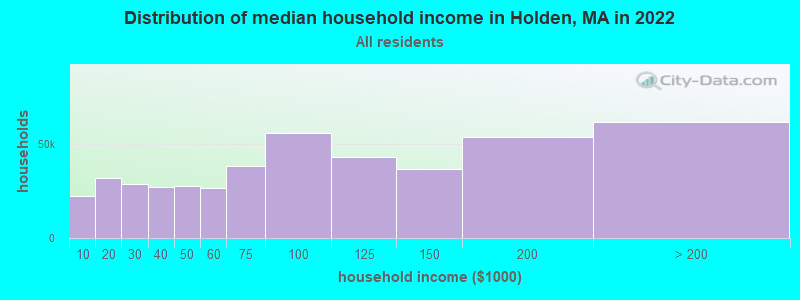
| Holden: | $115,848 |
| MA: | $94,488 |
Estimated per capita income in 2022: $54,538 (it was $27,971 in 2000)
Holden town income, earnings, and wages data
Estimated median house or condo value in 2022: $445,718 (it was $161,400 in 2000)
| Holden: | $445,718 |
| MA: | $534,700 |
Mean prices in 2022: all housing units: $419,164; detached houses: $447,621; townhouses or other attached units: $343,592; in 2-unit structures: $323,295; in 3-to-4-unit structures: $332,295; in 5-or-more-unit structures: $232,758; mobile homes: $113,885
Detailed information about poverty and poor residents in Holden, MA
Compare current foreclosures near Holden, MA:
| Photo | Address | Area | Beds / Baths | Price | Details |
|---|---|---|---|---|---|

|
#1
Raymond St
Holden, MA 01520
|
840 sq. feet
|
1 baths 2 beds |
show details | |

|
#2
Somerset Ln
Holden, MA 01520
|
1,152 sq. feet
|
1 baths 3 beds |
show details | |

|
#3
Holden St
Holden, MA 01520
|
1,844 sq. feet
|
2 baths 3 beds |
show details | |

|
#4
Union St
Holden, MA 01520
|
3,019 sq. feet
|
2 baths 4 beds |
show details | |

|
#5
Main St
Holden, MA 01520
|
1,830 sq. feet
|
1 baths 3 beds |
show details | |

|
#6
Central Park Apt 123
Holden, MA 01520
|
- sq. feet
|
- baths - beds |
show details | |

|
#7
Malden St
Holden, MA 01520
|
- sq. feet
|
- baths - beds |
show details | |

|
#8
Nome St
Worcester, MA 01605
|
960 sq. feet
|
1 baths 4 beds |
$208,000
|
show details |

|
#9
N Brookfield Rd
Oakham, MA 01068
|
1,078 sq. feet
|
1 baths 2 beds |
$459,900
|
show details |

|
#10
Sylvan Ave
Leominster, MA 01453
|
720 sq. feet
|
1 baths 2 beds |
$375,000
|
show details |
| Photo | Address | Area | Beds / Baths | Price | Details |
|---|---|---|---|---|---|

|
#11
Graham St
Leominster, MA 01453
|
1,036 sq. feet
|
1 baths 3 beds |
$485,000
|
show details |

|
#12
Eastern Ave
Worcester, MA 01605
|
1,736 sq. feet
|
3 baths 6 beds |
show details | |

|
#13
Treadwell Ter
Spencer, MA 01562
|
960 sq. feet
|
1 baths 3 beds |
show details | |

|
#14
Greenwood St
Worcester, MA 01607
|
1,337 sq. feet
|
1 baths 3 beds |
show details | |

|
#15
Pocasset Ave
Worcester, MA 01606
|
2,090 sq. feet
|
3 baths 3 beds |
show details | |

|
#16
Lorchris St
Leominster, MA 01453
|
1,032 sq. feet
|
1 baths 2 beds |
show details | |

|
#17
Chestnut St
North Brookfield, MA 01535
|
2,153 sq. feet
|
1 baths 3 beds |
show details | |

|
#18
Grove Ave
Leominster, MA 01453
|
3,097 sq. feet
|
1 baths 4 beds |
show details | |

|
#19
Richards St
Worcester, MA 01603
|
1,144 sq. feet
|
1 baths 3 beds |
show details | |

|
#20
Alberta Dr
Hudson, MA 01749
|
2,845 sq. feet
|
2 baths 3 beds |
show details |
| Photo | Address | Area | Beds / Baths | Price | Details |
|---|---|---|---|---|---|

|
#21
Leicester St
Auburn, MA 01501
|
912 sq. feet
|
1 baths 2 beds |
show details | |

|
#22
Mallard Drive, Unit 59 Coggshall Crossing Condominium
Fitchburg, MA 01420
|
1,306 sq. feet
|
1 baths 2 beds |
show details | |

|
#23
Old Bolton Rd
Hudson, MA 01749
|
1,244 sq. feet
|
1 baths 3 beds |
show details | |

|
#24
Greendale Ave
Marlborough, MA 01752
|
2,200 sq. feet
|
3 baths 5 beds |
show details | |

|
#25
Chestnut St
Spencer, MA 01562
|
1,078 sq. feet
|
1 baths 3 beds |
show details | |

|
#26
Clyde St
Fitchburg, MA 01420
|
2,028 sq. feet
|
3 baths 5 beds |
show details | |

|
#27
Hawkins St
Worcester, MA 01604
|
864 sq. feet
|
1 baths 3 beds |
show details | |

|
#28
Granville Ave
Worcester, MA 01606
|
1,354 sq. feet
|
1 baths 3 beds |
show details | |

|
#29
Garnet St
Fitchburg, MA 01420
|
6,112 sq. feet
|
5 baths 8 beds |
show details | |

|
#30
Old Meetinghouse Rd
Auburn, MA 01501
|
702 sq. feet
|
1 baths 2 beds |
show details |
| Photo | Address | Area | Beds / Baths | Price | Details |
|---|---|---|---|---|---|

|
#31
Pleasant St
Leominster, MA 01453
|
1,447 sq. feet
|
1 baths 3 beds |
show details | |

|
#32
Johnson St
Leominster, MA 01453
|
1,098 sq. feet
|
2 baths 3 beds |
show details | |

|
#33
Millbury St
Grafton, MA 01519
|
1,452 sq. feet
|
2 baths 3 beds |
show details | |

|
#34
Willow St
North Brookfield, MA 01535
|
1,200 sq. feet
|
1 baths 3 beds |
show details | |

|
#35
Emerald St
Gardner, MA 01440
|
1,428 sq. feet
|
1 baths 2 beds |
show details | |

|
#36
Malburn St
Leominster, MA 01453
|
1,008 sq. feet
|
1 baths 3 beds |
show details | |

|
#37
Millbury St
Grafton, MA 01519
|
1,840 sq. feet
|
2 baths 3 beds |
show details | |

|
#38
Coachman Ln
Auburn, MA 01501
|
1,072 sq. feet
|
1 baths 3 beds |
show details | |

|
#39
Greenwood Pl
Gardner, MA 01440
|
1,206 sq. feet
|
1 baths 2 beds |
show details | |

|
#40
Magnolia Ln
North Grafton, MA 01536
|
3,069 sq. feet
|
2 baths 4 beds |
show details |
| Photo | Address | Area | Beds / Baths | Price | Details |
|---|---|---|---|---|---|

|
#41
Bayberry Hill Ln
Leominster, MA 01453
|
1,083 sq. feet
|
1 baths 2 beds |
show details | |

|
#42
Old Turnpike Rd
Oakham, MA 01068
|
1,973 sq. feet
|
2 baths 3 beds |
show details | |

|
#43
Grafton St
Millbury, MA 01527
|
1,165 sq. feet
|
1 baths 2 beds |
show details | |

|
#44
Lyford Rd
Spencer, MA 01562
|
2,014 sq. feet
|
2 baths 2 beds |
show details | |

|
#45
W Main St
Millbury, MA 01527
|
750 sq. feet
|
1 baths 4 beds |
show details | |

|
#46
Main St
Lancaster, MA 01523
|
1,960 sq. feet
|
2 baths 3 beds |
show details | |

|
#47
Chapman Pl
Leominster, MA 01453
|
1,268 sq. feet
|
2 baths 2 beds |
show details | |

|
#48
Federal Hill Rd
Auburn, MA 01501
|
702 sq. feet
|
1 baths 2 beds |
show details | |

|
#49
Gatehouse Rd
Westminster, MA 01473
|
1,118 sq. feet
|
1 baths 2 beds |
show details | |

|
Check over 1 million property listings on Foreclosure.com!
|
browse all offers | |||

- 16,08692.7%White alone
- 5133.0%Asian alone
- 3732.2%Hispanic
- 1761.0%Two or more races
- 1630.9%Black alone
- 240.1%Other race alone
- 90.05%American Indian alone
- 20.01%Native Hawaiian and Other
Pacific Islander alone
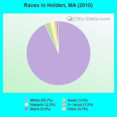
Races in Holden detailed stats: ancestries, foreign born residents, place of birth
Type |
2009 |
2010 |
2011 |
2012 |
2013 |
2014 |
2015 |
2016 |
2017 |
2018 |
2019 |
2020 |
2021 |
2022 |
|---|---|---|---|---|---|---|---|---|---|---|---|---|---|---|
| Murders (per 100,000) | 0 (0.0) | 0 (0.0) | 0 (0.0) | 0 (0.0) | 0 (0.0) | 0 (0.0) | 0 (0.0) | 0 (0.0) | 0 (0.0) | 1 (5.2) | 0 (0.0) | 0 (0.0) | 0 (0.0) | 0 (0.0) |
| Rapes (per 100,000) | 1 (5.9) | 1 (5.8) | 1 (5.7) | 3 (17.1) | 1 (5.6) | 6 (33.0) | 5 (26.6) | 2 (10.6) | 0 (0.0) | 7 (36.5) | 0 (0.0) | 2 (10.3) | 2 (10.2) | 3 (15.0) |
| Robberies (per 100,000) | 0 (0.0) | 0 (0.0) | 0 (0.0) | 1 (5.7) | 1 (5.6) | 1 (5.5) | 1 (5.3) | 0 (0.0) | 1 (5.2) | 0 (0.0) | 1 (5.2) | 0 (0.0) | 1 (5.1) | 1 (5.0) |
| Assaults (per 100,000) | 8 (47.6) | 12 (69.2) | 5 (28.7) | 4 (22.8) | 6 (33.8) | 6 (33.0) | 3 (16.0) | 11 (58.4) | 9 (47.2) | 5 (26.1) | 5 (26.0) | 4 (20.6) | 8 (40.8) | 17 (85.0) |
| Burglaries (per 100,000) | 16 (95.1) | 18 (103.8) | 21 (120.3) | 20 (113.9) | 21 (118.1) | 36 (197.7) | 24 (127.9) | 15 (79.7) | 9 (47.2) | 8 (41.7) | 2 (10.4) | 2 (10.3) | 5 (25.5) | 8 (40.0) |
| Thefts (per 100,000) | 85 (505.4) | 71 (409.3) | 91 (521.4) | 75 (427.1) | 71 (399.4) | 58 (318.5) | 62 (330.3) | 37 (196.5) | 39 (204.6) | 38 (198.2) | 27 (140.3) | 16 (82.4) | 24 (122.4) | 31 (155.0) |
| Auto thefts (per 100,000) | 6 (35.7) | 7 (40.4) | 5 (28.7) | 3 (17.1) | 4 (22.5) | 6 (33.0) | 1 (5.3) | 3 (15.9) | 4 (21.0) | 6 (31.3) | 10 (52.0) | 3 (15.5) | 1 (5.1) | 6 (30.0) |
| Arson (per 100,000) | 0 (0.0) | 2 (11.5) | 1 (5.7) | 1 (5.7) | 0 (0.0) | 3 (16.5) | 2 (10.7) | 1 (5.3) | 1 (5.2) | 0 (0.0) | 1 (5.2) | 3 (15.5) | 0 (0.0) | 1 (5.0) |
| City-Data.com crime index | 44.0 | 45.3 | 41.9 | 46.4 | 39.0 | 63.8 | 48.7 | 34.9 | 24.2 | 58.2 | 17.3 | 17.6 | 24.9 | 41.9 |
The City-Data.com crime index weighs serious crimes and violent crimes more heavily. Higher means more crime, U.S. average is 246.1. It adjusts for the number of visitors and daily workers commuting into cities.
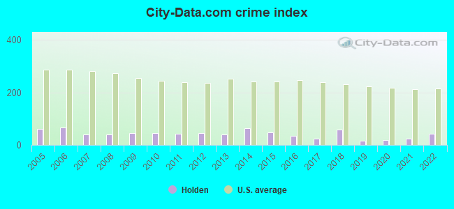
Crime rate in Holden detailed stats: murders, rapes, robberies, assaults, burglaries, thefts, arson
Full-time law enforcement employees in 2021, including police officers: 40 (24 officers - 20 male; 4 female).
| Officers per 1,000 residents here: | 1.22 |
| Massachusetts average: | 2.53 |
 Recent articles from our blog. Our writers, many of them Ph.D. graduates or candidates, create easy-to-read articles on a wide variety of topics.

 | Describe Holden? (48 replies) |
| Is Holden MA good place to raise a family? (22 replies) |
| Commute from Holden, MA to Belmont, mA (5 replies) |
| Moving Small Family to Worcester. Advice? (25 replies) |
| Moving to MA from out of state - figuring out how to pick the "right" suburb for me and my family (81 replies) |
| Holden or Rutland for new construction (4 replies) |
Latest news from Holden, MA collected exclusively by city-data.com from local newspapers, TV, and radio stations
Ancestries: Irish (29.4%), English (18.1%), French (13.0%), Italian (12.3%), Swedish (8.4%), German (7.7%).
Current Local Time: EST time zone
Incorporated in 1741
Elevation: 860 feet
Land area: 35.0 square miles.
Population density: 496 people per square mile (low).
614 residents are foreign born (2.1% Europe, 1.2% Asia).
| This town: | 3.9% |
| Massachusetts: | 12.2% |
| Holden town: | 1.6% ($2,594) |
| Massachusetts: | 1.3% ($2,336) |
Nearest city with pop. 50,000+: Worcester, MA  (6.0 miles , pop. 172,648).
Nearest city with pop. 200,000+: Boston, MA (39.0 miles , pop. 589,141).
Nearest city with pop. 1,000,000+: Bronx, NY (147.4 miles , pop. 1,332,650).
Nearest cities:
), Latitude: 42.35 N, Longitude: 71.85 W
Area codes: 508, 774

Holden, Massachusetts accommodation & food services, waste management - Economy and Business Data
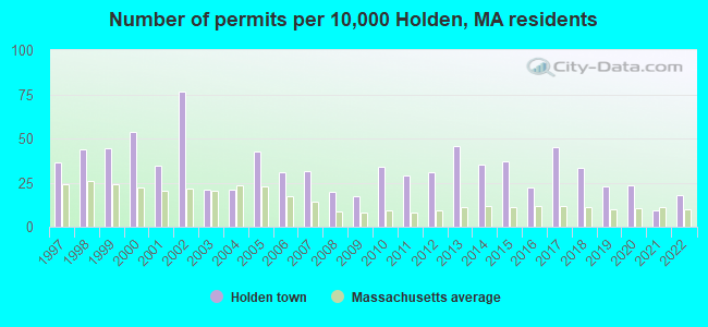
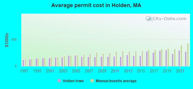
Single-family new house construction building permits:
- 2022: 28 buildings, average cost: $276,800
- 2021: 14 buildings, average cost: $298,500
- 2020: 37 buildings, average cost: $236,600
- 2019: 36 buildings, average cost: $303,600
- 2018: 52 buildings, average cost: $295,400
- 2017: 70 buildings, average cost: $261,800
- 2016: 35 buildings, average cost: $273,600
- 2015: 58 buildings, average cost: $199,800
- 2014: 55 buildings, average cost: $199,600
- 2013: 71 buildings, average cost: $213,900
- 2012: 48 buildings, average cost: $180,200
- 2011: 45 buildings, average cost: $186,300
- 2010: 53 buildings, average cost: $180,900
- 2009: 27 buildings, average cost: $184,100
- 2008: 31 buildings, average cost: $177,100
- 2007: 49 buildings, average cost: $178,500
- 2006: 48 buildings, average cost: $184,600
- 2005: 67 buildings, average cost: $206,000
- 2004: 33 buildings, average cost: $207,000
- 2003: 33 buildings, average cost: $174,200
- 2002: 120 buildings, average cost: $168,400
- 2001: 54 buildings, average cost: $154,600
- 2000: 84 buildings, average cost: $155,800
- 1999: 69 buildings, average cost: $150,500
- 1998: 68 buildings, average cost: $130,600
- 1997: 57 buildings, average cost: $122,100
| Here: | 2.9% |
| Massachusetts: | 3.5% |

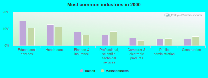
- Educational services (14.7%)
- Health care (12.6%)
- Finance & insurance (8.1%)
- Professional, scientific, technical services (6.1%)
- Computer & electronic products (4.6%)
- Public administration (4.0%)
- Construction (4.0%)
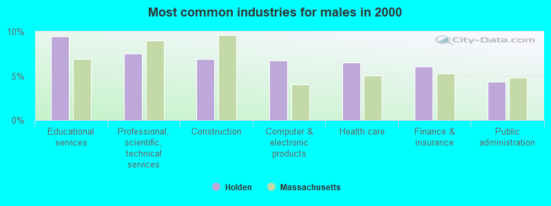
- Educational services (9.4%)
- Professional, scientific, technical services (7.5%)
- Construction (6.9%)
- Computer & electronic products (6.8%)
- Health care (6.5%)
- Finance & insurance (6.1%)
- Public administration (4.3%)
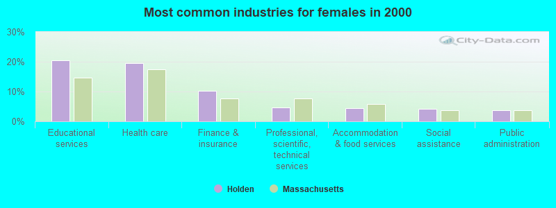
- Educational services (20.6%)
- Health care (19.5%)
- Finance & insurance (10.3%)
- Professional, scientific, technical services (4.6%)
- Accommodation & food services (4.3%)
- Social assistance (4.2%)
- Public administration (3.6%)
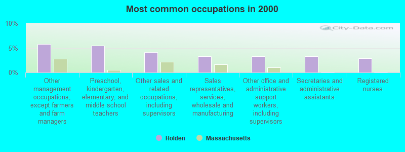
- Other management occupations, except farmers and farm managers (5.7%)
- Preschool, kindergarten, elementary, and middle school teachers (5.5%)
- Other sales and related occupations, including supervisors (4.2%)
- Sales representatives, services, wholesale and manufacturing (3.3%)
- Other office and administrative support workers, including supervisors (3.3%)
- Secretaries and administrative assistants (3.2%)
- Registered nurses (2.9%)
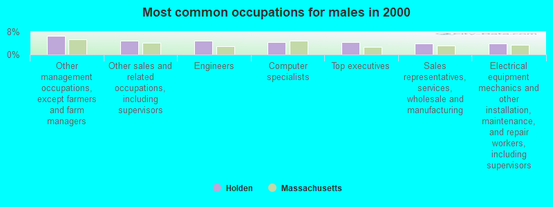
- Other management occupations, except farmers and farm managers (6.6%)
- Other sales and related occupations, including supervisors (5.0%)
- Engineers (4.8%)
- Computer specialists (4.3%)
- Top executives (4.3%)
- Sales representatives, services, wholesale and manufacturing (4.0%)
- Electrical equipment mechanics and other installation, maintenance, and repair workers, including supervisors (3.8%)
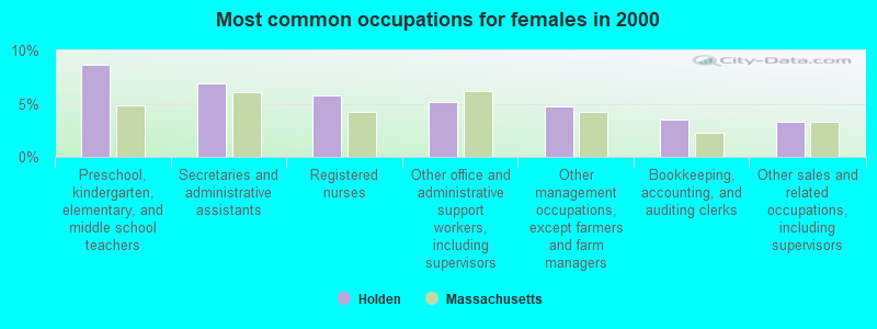
- Preschool, kindergarten, elementary, and middle school teachers (8.6%)
- Secretaries and administrative assistants (6.9%)
- Registered nurses (5.8%)
- Other office and administrative support workers, including supervisors (5.2%)
- Other management occupations, except farmers and farm managers (4.7%)
- Bookkeeping, accounting, and auditing clerks (3.6%)
- Other sales and related occupations, including supervisors (3.3%)
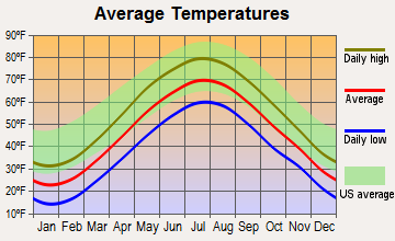
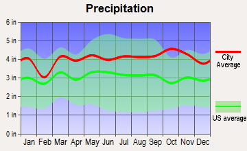
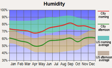
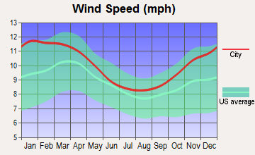
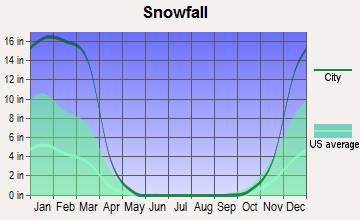
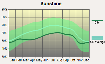
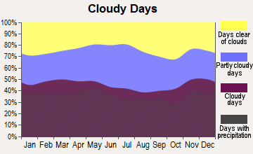
Average climate in Holden, Massachusetts
Based on data reported by over 4,000 weather stations
(lower is better)
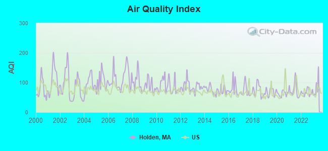
Air Quality Index (AQI) level in 2022 was 66.7. This is about average.
| City: | 66.7 |
| U.S.: | 72.6 |
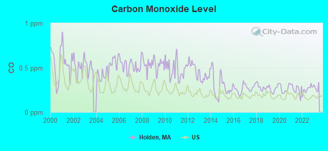
Carbon Monoxide (CO) [ppm] level in 2022 was 0.259. This is about average. Closest monitor was 6.2 miles away from the city center.
| City: | 0.259 |
| U.S.: | 0.251 |
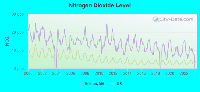
Nitrogen Dioxide (NO2) [ppb] level in 2022 was 10.1. This is significantly worse than average. Closest monitor was 6.2 miles away from the city center.
| City: | 10.1 |
| U.S.: | 5.1 |
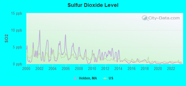
Sulfur Dioxide (SO2) [ppb] level in 2022 was 0.360. This is significantly better than average. Closest monitor was 6.3 miles away from the city center.
| City: | 0.360 |
| U.S.: | 1.515 |
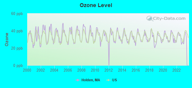
Ozone [ppb] level in 2022 was 32.1. This is about average. Closest monitor was 5.3 miles away from the city center.
| City: | 32.1 |
| U.S.: | 33.3 |
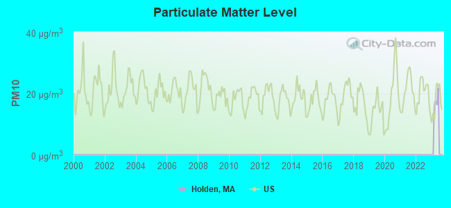
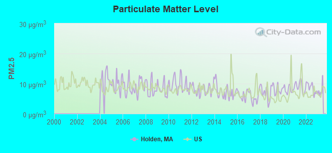
Particulate Matter (PM2.5) [µg/m3] level in 2022 was 8.57. This is about average. Closest monitor was 6.5 miles away from the city center.
| City: | 8.57 |
| U.S.: | 8.11 |
Tornado activity:
Holden-area historical tornado activity is slightly above Massachusetts state average. It is 18% smaller than the overall U.S. average.
On 6/9/1953, a category F4 (max. wind speeds 207-260 mph) tornado 17.2 miles away from the Holden town center killed 90 people and injured 1228 people and caused between $50,000,000 and $500,000,000 in damages.
On 6/9/1953, a category F3 (max. wind speeds 158-206 mph) tornado 13.0 miles away from the town center injured 17 people and caused between $500,000 and $5,000,000 in damages.
Earthquake activity:
Holden-area historical earthquake activity is significantly above Massachusetts state average. It is 71% smaller than the overall U.S. average.On 10/7/1983 at 10:18:46, a magnitude 5.3 (5.1 MB, 5.3 LG, 5.1 ML, Class: Moderate, Intensity: VI - VII) earthquake occurred 167.7 miles away from Holden center
On 4/20/2002 at 10:50:47, a magnitude 5.3 (5.3 ML, Depth: 3.0 mi) earthquake occurred 176.1 miles away from Holden center
On 4/20/2002 at 10:50:47, a magnitude 5.2 (5.2 MB, 4.2 MS, 5.2 MW, 5.0 MW) earthquake occurred 175.2 miles away from the city center
On 1/19/1982 at 00:14:42, a magnitude 4.7 (4.5 MB, 4.7 MD, 4.5 LG, Class: Light, Intensity: IV - V) earthquake occurred 80.7 miles away from the city center
On 10/16/2012 at 23:12:25, a magnitude 4.7 (4.7 ML, Depth: 10.0 mi) earthquake occurred 105.5 miles away from the city center
On 8/22/1992 at 12:20:32, a magnitude 4.8 (4.8 MB, 3.8 MS, 4.7 LG, Depth: 6.2 mi) earthquake occurred 238.2 miles away from Holden center
Magnitude types: regional Lg-wave magnitude (LG), body-wave magnitude (MB), duration magnitude (MD), local magnitude (ML), surface-wave magnitude (MS), moment magnitude (MW)
Natural disasters:
The number of natural disasters in Worcester County (27) is a lot greater than the US average (15).Major Disasters (Presidential) Declared: 15
Emergencies Declared: 12
Causes of natural disasters: Floods: 9, Storms: 8, Hurricanes: 6, Snowstorms: 5, Winter Storms: 4, Blizzards: 2, Snows: 2, Fire: 1, Heavy Rain: 1, Snowfall: 1, Tornado: 1, Wind: 1 (Note: some incidents may be assigned to more than one category).
Hospitals and medical centers in Holden:
Airports located in Holden:
- Marshall's Airport (MA16) (Runways: 1)
Amtrak station near Holden:
Colleges/universities with over 2000 students nearest to Holden:
- Quinsigamond Community College (about 4 miles; Worcester, MA; Full-time enrollment: 5,877)
- Assumption College (about 4 miles; Worcester, MA; FT enrollment: 2,580)
- Worcester Polytechnic Institute (about 6 miles; Worcester, MA; FT enrollment: 3,930)
- Worcester State University (about 6 miles; Worcester, MA; FT enrollment: 5,426)
- Clark University (about 7 miles; Worcester, MA; FT enrollment: 3,687)
- College of the Holy Cross (about 8 miles; Worcester, MA; FT enrollment: 3,125)
- Fitchburg State University (about 17 miles; Fitchburg, MA; FT enrollment: 5,010)
Public high school in Holden:
- WACHUSETT REGIONAL HIGH (Students: 1,905, Location: 1401 MAIN STREET, Grades: 9-12)
Public elementary/middle schools in Holden:
- MOUNTVIEW MIDDLE (Students: 736, Location: 270 SHREWSBURY STREET, Grades: 6-8)
- DAWSON (Students: 526, Location: 155 SALISBURY STREET, Grades: KG-5)
- DAVIS HILL ELEMENTARY (Students: 524, Location: 78 JAMIESON ROAD, Grades: KG-5)
- LEROY E.MAYO (Students: 492, Location: 351 BULLARD STREET, Grades: KG-5)
Private elementary/middle school in Holden:
Points of interest:
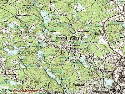
Notable locations in Holden: Holden Hills Country Club (A), Camp Kinneywood (B), Fairbrook Country Club (C), Holden Fire Department Station 2 (D), Holden Fire Department Station 1 Headquarters (E), Wachusett Regional High School Media Center (F), Holden Town Hall (G), Gale Free Library (H). Display/hide their locations on the map
Shopping Center: Holden Shopping Center (1). Display/hide its location on the map
Churches in Holden include: Emmanuel Church (A), Immanuel Church (B), Wachusett Valley Baptist Church (C), Saint Marys Church (D), First Congregational Church (E), First Baptist Church (F). Display/hide their locations on the map
Cemetery: Grove Cemetery (1). Display/hide its location on the map
Lakes and reservoirs: Poutwater Pond (A), Chaffin Pond (B), Bryant Pond (C), Maple Spring Pond (D), Kendall Reservoir (E), Eagle Lake (F), Quinapoxet Reservoir (G), Holden Reservoir Number One (H). Display/hide their locations on the map
Streams, rivers, and creeks: Muschopauge Brook (A), Scott Brook (B), Chaffins Brook (C), Silver Spring Brook (D), Tatnuck Brook (E), Wadsworth Brook (F), Worcester Brook (G), Asnebumskit Brook (H), Ball Brook (I). Display/hide their locations on the map
Park in Holden: Holden Center Historic District (1). Display/hide its location on the map
Tourist attraction: Holden Historical Society Inc (Cultural Attractions- Events- & Facilities; 1157 Main Street) (1). Display/hide its approximate location on the map
Birthplace of: Bob Ritter - Football player and coach, Samuel C. Damon - Congregationalist cleric, Bruce Taylor (baseball) - Baseball player, Ron Hallstrom - Football player.
Drinking water stations with addresses in Holden and their reported violations in the past:
HOLDEN WATER DIVISION, DPW (Population served: 15,168, Purch surface water):Past monitoring violations:
- One regular monitoring violation
| This town: | 2.7 people |
| Massachusetts: | 2.5 people |
| This town: | 76.7% |
| Whole state: | 63.0% |
| This town: | 4.5% |
| Whole state: | 7.0% |
Likely homosexual households (counted as self-reported same-sex unmarried-partner households)
- Lesbian couples: 0.4% of all households
- Gay men: 0.3% of all households
| This town: | 3.1% |
| Whole state: | 9.3% |
| This town: | 1.5% |
| Whole state: | 4.4% |
11 people in group homes intended for adults in 2010
137 people in nursing homes in 2000
9 people in homes for the mentally retarded in 2000
Banks with branches in Holden (2011 data):
- Sovereign Bank, National Association: Holden Branch at 164 Reservoir Street, branch established on 1934/01/01. Info updated 2012/01/31: Bank assets: $78,146.9 mil, Deposits: $48,042.9 mil, headquarters in Wilmington, DE, positive income, Commercial Lending Specialization, 718 total offices, Holding Company: Banco Santander, S.A.
- Commerce Bank & Trust Company: Holden Branch at 1059 Main Street, branch established on 1996/10/01. Info updated 2006/10/06: Bank assets: $1,410.8 mil, Deposits: $1,187.6 mil, headquarters in Worcester, MA, positive income, Commercial Lending Specialization, 14 total offices, Holding Company: Commerce Bancshares Corp.
- Bank of America, National Association: Holden Branch at 560 Main Street, branch established on 1967/09/11. Info updated 2009/11/18: Bank assets: $1,451,969.3 mil, Deposits: $1,077,176.8 mil, headquarters in Charlotte, NC, positive income, 5782 total offices, Holding Company: Bank Of America Corporation
- Bay State Savings Bank: Holden Branch at 628 Main Street, branch established on 1997/01/21. Info updated 2011/08/17: Bank assets: $268.4 mil, Deposits: $214.3 mil, headquarters in Worcester, MA, positive income, Commercial Lending Specialization, 8 total offices, Holding Company: 1895 Mhc
- Southbridge Savings Bank: Holden Branch at 1073 Main Street, branch established on 2003/06/04. Info updated 2008/10/14: Bank assets: $419.3 mil, Deposits: $329.4 mil, headquarters in Southbridge, MA, positive income, Commercial Lending Specialization, 9 total offices, Holding Company: Green Valley Bancorp, Mhc
For population 15 years and over in Holden:
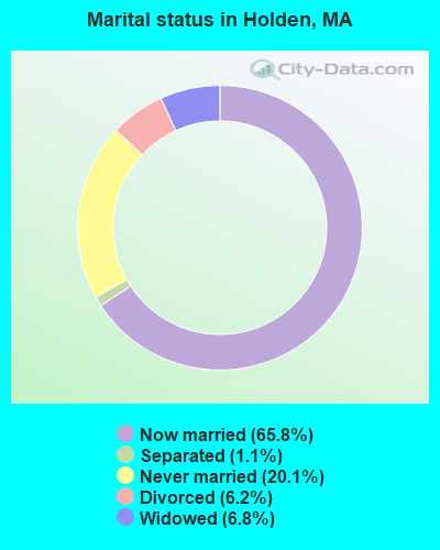
- Never married: 20.1%
- Now married: 65.8%
- Separated: 1.1%
- Widowed: 6.8%
- Divorced: 6.2%
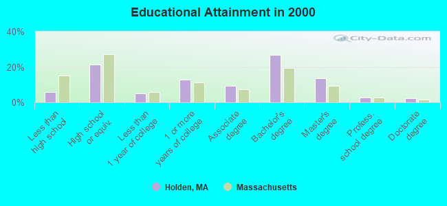
For population 25 years and over in Holden:
- High school or higher: 94.0%
- Bachelor's degree or higher: 45.4%
- Graduate or professional degree: 18.6%
- Unemployed: 2.9%
- Mean travel time to work (commute): 25.4 minutes
| Here: | 10.3 |
| Massachusetts average: | 13.1 |


Graphs represent county-level data. Detailed 2008 Election Results
Religion statistics for Holden, MA (based on Worcester County data)


| Religion | Adherents | Congregations |
|---|---|---|
| Catholic | 306,925 | 118 |
| Mainline Protestant | 43,326 | 171 |
| Evangelical Protestant | 37,511 | 203 |
| Other | 18,931 | 69 |
| Orthodox | 7,935 | 15 |
| Black Protestant | 497 | 6 |
| None | 383,427 | - |
Food Environment Statistics:
| Worcester County: | 1.73 / 10,000 pop. |
| Massachusetts: | 1.98 / 10,000 pop. |
| Here: | 0.05 / 10,000 pop. |
| Massachusetts: | 0.05 / 10,000 pop. |
| This county: | 1.79 / 10,000 pop. |
| State: | 2.22 / 10,000 pop. |
| This county: | 2.22 / 10,000 pop. |
| Massachusetts: | 1.77 / 10,000 pop. |
| This county: | 7.27 / 10,000 pop. |
| Massachusetts: | 8.76 / 10,000 pop. |
| Worcester County: | 8.0% |
| Massachusetts: | 8.1% |
| Here: | 24.0% |
| Massachusetts: | 22.5% |
| Worcester County: | 16.6% |
| Massachusetts: | 16.5% |
4.71% of this county's 2021 resident taxpayers lived in other counties in 2020 ($76,229 average adjusted gross income)
| Here: | 4.71% |
| Massachusetts average: | 6.35% |
0.02% of residents moved from foreign countries ($100 average AGI)
Worcester County: 0.02% Massachusetts average: 0.01%
Top counties from which taxpayers relocated into this county between 2020 and 2021:
| from Middlesex County, MA | |
| from Norfolk County, MA | |
| from Suffolk County, MA |
4.84% of this county's 2020 resident taxpayers moved to other counties in 2021 ($87,252 average adjusted gross income)
| Here: | 4.84% |
| Massachusetts average: | 7.18% |
0.03% of residents moved to foreign countries ($199 average AGI)
Worcester County: 0.03% Massachusetts average: 0.02%
Top counties to which taxpayers relocated from this county between 2020 and 2021:
| to Middlesex County, MA | |
| to Norfolk County, MA | |
| to Suffolk County, MA |
| Businesses in Holden, MA | ||||
| Name | Count | Name | Count | |
|---|---|---|---|---|
| Ace Hardware | 1 | McDonald's | 1 | |
| CVS | 1 | Penske | 1 | |
| Curves | 1 | Rite Aid | 1 | |
| Dunkin Donuts | 2 | Subway | 1 | |
| FedEx | 1 | Talbots | 1 | |
| Ford | 1 | UPS | 1 | |
| Jones New York | 1 | Walgreens | 1 | |
Strongest AM radio stations in Holden:
- WTAG (580 AM; 5 kW; WORCESTER, MA; Owner: CAPSTAR TX LIMITED PARTNERSHIP)
- WCRN (830 AM; 50 kW; WORCESTER, MA; Owner: CARTER BROADCASTING CORPORATION)
- WVEI (1440 AM; 5 kW; WORCESTER, MA; Owner: ENTERCOM BOSTON LICENSE, LLC)
- WVNE (760 AM; daytime; 25 kW; LEICESTER, MA; Owner: BLOUNT MASSCOM, INC.)
- WKOX (1200 AM; 50 kW; FRAMINGHAM, MA; Owner: CAPSTAR TX LIMITED PARTNERSHIP)
- WBIX (1060 AM; 40 kW; NATICK, MA; Owner: LANGER BROADCASTING CORPORATION)
- WEEI (850 AM; 50 kW; BOSTON, MA; Owner: ENTERCOM BOSTON LICENSE, LLC)
- WRKO (680 AM; 50 kW; BOSTON, MA; Owner: ENTERCOM BOSTON LICENSE, LLC)
- WALE (990 AM; 50 kW; GREENVILLE, RI; Owner: NORTH AMERICAN BROADCASTING CO., INC.)
- WAMG (890 AM; 25 kW; DEDHAM, MA; Owner: MEGA COMMUNICATIONS OF DEDHAM LICENSEE, LLC)
- WORC (1310 AM; 5 kW; WORCESTER, MA; Owner: CHOWDER BROADCAST GROUP LLC)
- WNNZ (640 AM; 50 kW; WESTFIELD, MA; Owner: CLEAR CHANNEL BROADCASTING LICENSES, INC.)
- WWZN (1510 AM; 50 kW; BOSTON, MA; Owner: ROSE CITY RADIO CORPORATION)
Strongest FM radio stations in Holden:
- WAAF (107.3 FM; WORCESTER, MA; Owner: ENTERCOM BOSTON LICENSE, LLC)
- WSRS (96.1 FM; WORCESTER, MA; Owner: CAPSTAR TX LIMITED PARTNERSHIP)
- WXLO (104.5 FM; FITCHBURG, MA; Owner: CITADEL BROADCASTING COMPANY)
- WICN (90.5 FM; WORCESTER, MA; Owner: WICN PUBLIC RADIO, INC)
- WBPR (91.9 FM; WORCESTER, MA; Owner: UNIVERSITY OF MASSACHUSETTS)
- WCUW (91.3 FM; WORCESTER, MA; Owner: WUW, INC.)
- WFEX (92.1 FM; PETERBOROUGH, NH; Owner: FNX BROADCASTING OF NEW HAMPSHIRE LLC)
- WBMX (98.5 FM; BOSTON, MA; Owner: INFINITY RADIO OPERATIONS INC.)
- WJMN (94.5 FM; BOSTON, MA; Owner: AMFM RADIO LICENSES, L.L.C.)
- WCRB (102.5 FM; WALTHAM, MA; Owner: CHARLES RIVER BROADCASTING WCRB LICE)
- WTKK (96.9 FM; BOSTON, MA; Owner: GREATER BOSTON RADIO, INC.)
- WROR-FM (105.7 FM; FRAMINGHAM, MA; Owner: GREATER BOSTON RADIO, INC.)
- WBOS (92.9 FM; BROOKLINE, MA; Owner: GREATER BOSTON RADIO, INC.)
- WFCR (88.5 FM; AMHERST, MA; Owner: UNIVERSITY OF MASSACHUSETTS)
- WGBH (89.7 FM; BOSTON, MA; Owner: WGBH EDUCATIONAL FOUNDATION)
- WYCM (90.1 FM; CHARLTON, MA; Owner: BAY PATH VOCATIONAL HIGH SCHOOL)
- WBUR-FM (90.9 FM; BOSTON, MA; Owner: TRUSTEES OF BOSTON UNIVERSITY)
- WXKS-FM (107.9 FM; MEDFORD, MA; Owner: AMFM RADIO LICENSES, L.L.C.)
- WODS (103.3 FM; BOSTON, MA; Owner: INFINITY BROADCASTING OPERATIONS, INC.)
- WMJX (106.7 FM; BOSTON, MA; Owner: GREATER BOSTON RADIO, INC.)
TV broadcast stations around Holden:
- WUNI (Channel 27; WORCESTER, MA; Owner: ENTRAVISION HOLDINGS, LLC)
- WUTF (Channel 66; MARLBOROUGH, MA; Owner: TELEFUTURA BOSTON LLC)
- WCRN-LP (Channel 34; LEICESTER, MA; Owner: CARTER BROADCASTING CORPORATION)
- WYDN (Channel 48; WORCESTER, MA; Owner: EDUCATIONAL PUBLIC TV CORPORATION)
- WCVB-TV (Channel 5; BOSTON, MA; Owner: WCVB HEARST-ARGYLE TV, INC.)
- WGBH-TV (Channel 2; BOSTON, MA; Owner: WGBH EDUCATIONAL FOUNDATION)
- WHDH-TV (Channel 7; BOSTON, MA; Owner: WHDH-TV)
- WMFP (Channel 62; LAWRENCE, MA; Owner: WSAH LICENSE, INC.)
- WBZ-TV (Channel 4; BOSTON, MA; Owner: VIACOM INC.)
- WGBX-TV (Channel 44; BOSTON, MA; Owner: WGBH EDUCATIONAL FOUNDATION)
- WSBK-TV (Channel 38; BOSTON, MA; Owner: VIACOM INC.)
- WLVI-TV (Channel 56; CAMBRIDGE, MA; Owner: WLVI, INC.)
- WFXT (Channel 25; BOSTON, MA; Owner: FOX TELEVISION STATIONS INC.)
- W40BO (Channel 40; BOSTON, MA; Owner: PAXSON COMMUNICATIONS LPTV, INC.)
- WBPX (Channel 68; BOSTON, MA; Owner: PAXSON BOSTON-68 LICENSE, INC.)
- WPXQ (Channel 69; BLOCK ISLAND, RI; Owner: OCEAN STATE TELEVISION, L.L.C.)
- WNAC-TV (Channel 64; PROVIDENCE, RI; Owner: WNAC, LLC)
- WTMU-LP (Channel 32; BOSTON, MA; Owner: ZGS BOSTON, INC.)
- WCEA-LP (Channel 58; BOSTON, MA; Owner: CHANNEL 19 TV CORPORATION)
- National Bridge Inventory (NBI) Statistics
- 19Number of bridges
- 305ft / 92.6mTotal length
- $63,166,000Total costs
- 146,053Total average daily traffic
- 9,783Total average daily truck traffic
- 214,990Total future (year 2031) average daily traffic
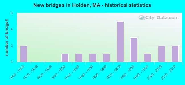
- New bridges - historical statistics
- 21900-1909
- 11930-1939
- 11940-1949
- 11950-1959
- 11960-1969
- 51970-1979
- 31980-1989
- 11990-1999
- 22000-2009
- 22010-2019
FCC Registered Private Land Mobile Towers: 1 (See the full list of FCC Registered Private Land Mobile Towers in Holden, MA)
FCC Registered Broadcast Land Mobile Towers: 9 (See the full list of FCC Registered Broadcast Land Mobile Towers)
FCC Registered Microwave Towers: 12 (See the full list of FCC Registered Microwave Towers in this town)
FCC Registered Amateur Radio Licenses: 97 (See the full list of FCC Registered Amateur Radio Licenses in Holden)
FAA Registered Aircraft: 10 (See the full list of FAA Registered Aircraft in Holden)
2002 - 2018 National Fire Incident Reporting System (NFIRS) incidents
- Fire incident types reported to NFIRS in Holden, MA
- 42353.1%Structure Fires
- 24630.9%Outside Fires
- 8110.2%Mobile Property/Vehicle Fires
- 475.9%Other
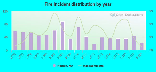 According to the data from the years 2002 - 2018 the average number of fires per year is 47. The highest number of reported fires - 88 took place in 2008, and the least - 19 in 2012. The data has a declining trend.
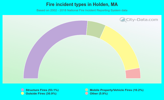 When looking into fire subcategories, the most reports belonged to: Structure Fires (53.1%), and Outside Fires (30.9%).
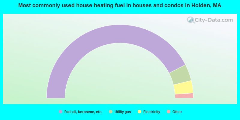
- 85.0%Fuel oil, kerosene, etc.
- 7.3%Utility gas
- 5.5%Electricity
- 1.3%Wood
- 0.7%Bottled, tank, or LP gas
- 0.2%Other fuel
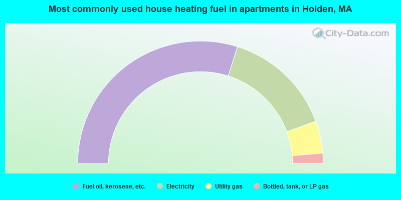
- 59.7%Fuel oil, kerosene, etc.
- 29.0%Electricity
- 8.5%Utility gas
- 2.7%Bottled, tank, or LP gas
Holden compared to Massachusetts state average:
- Unemployed percentage significantly below state average.
- Black race population percentage significantly below state average.
- Hispanic race population percentage significantly below state average.
- Foreign-born population percentage significantly below state average.
- Renting percentage significantly below state average.
- Length of stay since moving in significantly above state average.
- Number of rooms per house significantly below state average.
- House age significantly below state average.
Holden on our top lists:
- #19 on the list of "Top 101 cities with largest percentage of males in industries: retail florists (population 5,000+)"
- #26 on the list of "Top 101 cities with largest percentage of males in occupations: librarians, curators, and archivists (population 5,000+)"
- #34 on the list of "Top 101 cities with largest percentage of males in industries: nonmetallic mineral products (population 5,000+)"
- #37 on the list of "Top 101 cities with largest percentage of males in occupations: preschool, kindergarten, elementary and middle school teachers (population 5,000+)"
- #43 on the list of "Top 101 cities with largest percentage of males in occupations: operations specialties managers except financial managers (population 5,000+)"
- #52 on the list of "Top 101 cities with largest percentage of females in occupations: postsecondary teachers (population 5,000+)"
- #58 on the list of "Top 101 cities with largest percentage of males in occupations: mathematical science occupations (population 5,000+)"
- #67 on the list of "Top 101 cities with largest percentage of males in industries: water transportation (population 5,000+)"
- #72 on the list of "Top 101 cities with largest percentage of females in occupations: preschool, kindergarten, elementary and middle school teachers (population 5,000+)"
- #78 on the list of "Top 101 cities with largest percentage of males in industries: lumber and other construction materials merchant wholesalers (population 5,000+)"
- #83 on the list of "Top 101 cities with largest percentage of females in industries: retail florists (population 5,000+)"
- #86 on the list of "Top 101 cities with largest percentage of males in industries: computer and electronic products (population 5,000+)"
- #94 on the list of "Top 101 cities with largest percentage of males in industries: social assistance (population 5,000+)"
- #98 on the list of "Top 101 cities with largest percentage of females in industries: pharmacies and drug stores (population 5,000+)"
- #4 on the list of "Top 101 counties with the highest carbon monoxide air pollution readings in 2012 (ppm)"
- #5 on the list of "Top 101 counties with the most Catholic congregations"
- #12 on the list of "Top 101 counties with the highest surface withdrawal of fresh water for public supply"
- #16 on the list of "Top 101 counties with the highest total withdrawal of fresh water for public supply"
- #23 on the list of "Top 101 counties with the highest Sulfur Oxides Annual air pollution readings in 2012 (µg/m3)"

|
|
Total of 450 patent applications in 2008-2024.