Bridge Statistics for West Boylston, Massachusetts (MA)
Condition, Traffic, Stress, Structural Evaluation, Project Costs
- National Bridge Inventory (NBI) Statistics
- 17Number of bridges
- 164ft / 50.0mTotal length
- $42,153,000Total costs
- 216,925Total average daily traffic
- 18,907Total average daily truck traffic
- 474,102Total future (year 2031) average daily traffic
- National Bridge Inventory (NBI) Registered Bridges for West Boylston
- No street view available for this location
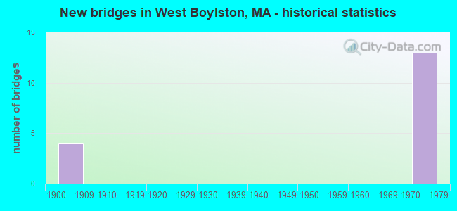
- New bridges - historical statistics
- 41900-1909
- 131970-1979
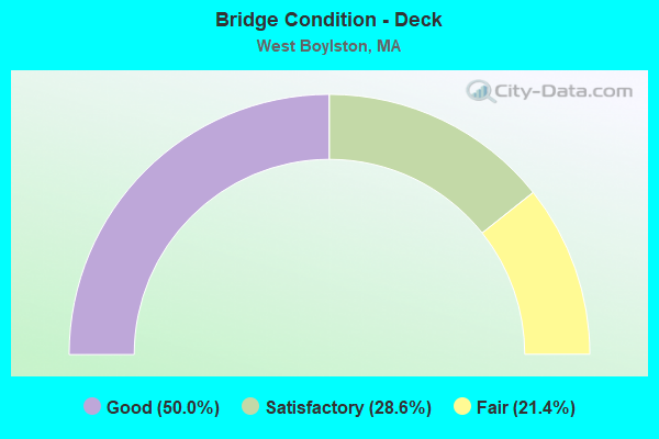
- Bridge Condition - Deck
- 50.0%Good
- 28.6%Satisfactory
- 21.4%Fair
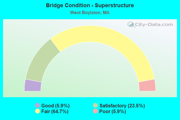
- Bridge Condition - Superstructure
- 5.9%Good
- 23.5%Satisfactory
- 64.7%Fair
- 5.9%Poor
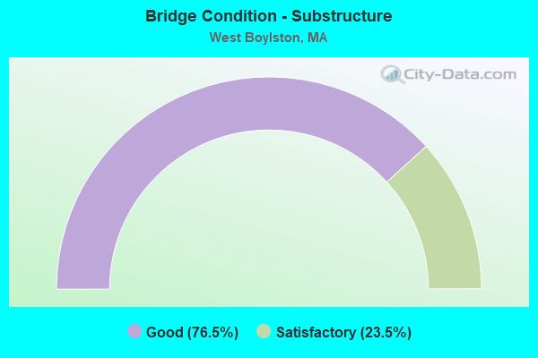
- Bridge Condition - Substructure
- 76.5%Good
- 23.5%Satisfactory
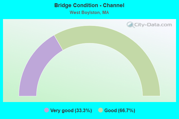
- Bridge Condition - Channel
- 33.3%Very good
- 66.7%Good
Find on map >> Show street view
Structure Number: W170014CVDOTNBI, Location: AT QUINEPOXET RIVER (Lat: 42.385025, Lng: -71.797117), Route carried "on" structure: City street , Year Built: 1904, Status: Open, Structure Length: 3.05m (10.01ft), Average Daily Traffic: 5,820 (year 2014), Truck Traffic: 6%, Average Future Daily Traffic: 9,192 (year 2031), Features Intersected: WATER QUINAPOXET RIVER, Facility Carried by Structure: HWY THOMAS ST
Minimum Vertical Clearance: 30+ m (98+ ft), Kilometerpoint: 0.016, Lanes on structure: 2, Owner: State Highway Agency, Approaching Roadway Width: 9.1m (29.9ft), Material/Design: Concrete, Design/Construction: Arch - Deck, Number Of Spans In Main Unit: 3, Length of Maximum Span: 8.5m (27.9ft), Curb-To-Curb Width: 8.5m (27.9ft), Out-to-Out Width: 10.5m (34.4ft)
Condition: Superstructure: Fair, Substructure: Satisfactory, Channel: Good, Operating Rating: 53.0 metric tons, Method Used To Determine Operating Rating: Load Factor (LF), Inventory Rating: 40.8 metric tons, Method Used To Determine Inventory Rating: Load Factor (LF), Structural Evaluation: Somewhat better than minimum adequacy, Deck Geometry: High priority of replacement, Waterway Adequacy: Better than present minimum criteria, Approach Roadway Alignment: Better than present minimum criteria, Length Of Structure Improvement: 3.10m (10.17ft), Designated Inspection Frequency: Every 24 months, Underwater Inspection Frequency: Every 36 months, Inspection Date: July 2020, Underwater Inspection Date: July 2020, Bridge Improvement Cost: $1,279,000, Roadway Improvement Cost: $128,000, Total Project Cost: $1,919,000 ( Estimate for 2022)
Find on map >> Show street view
Structure Number: W170034CWDOTNBI, Location: .2 MI E OF THOMAS ST. (Lat: 42.387117, Lng: -71.790486), Route carried "on" structure: State highway 140, Year Built: 1904, Status: Open, Structure Length: 1.07m (3.51ft), Average Daily Traffic: 9,214 (year 2018), Truck Traffic: 10%, Average Future Daily Traffic: 8,370 (year 2032), Design Load: H 20, Features Intersected: WATER STILLWATER RIVER
Minimum Vertical Clearance: 30+ m (98+ ft), Kilometerpoint: 133.595, Lanes on structure: 2, Owner: State Highway Agency, Approaching Roadway Width: 8.2m (26.9ft), Material/Design: Concrete, Design/Construction: Arch - Deck, Number Of Spans In Main Unit: 1, Length of Maximum Span: 10.7m (35.1ft), Curb-To-Curb Width: 8.1m (26.6ft), Out-to-Out Width: 9.9m (32.5ft)
Condition: Superstructure: Satisfactory, Substructure: Good, Channel: Good, Operating Rating: 50.4 metric tons, Method Used To Determine Operating Rating: Load Factor (LF), Inventory Rating: 32.5 metric tons, Method Used To Determine Inventory Rating: Load Factor (LF), Structural Evaluation: Equal to present minimum criteria, Deck Geometry: High priority of replacement, Waterway Adequacy: Somewhat better than minimum adequacy, Approach Roadway Alignment: Somewhat better than minimum adequacy, Length Of Structure Improvement: 1.10m (3.61ft), Designated Inspection Frequency: Every 24 months, Underwater Inspection Frequency: Every 36 months, Inspection Date: August 2021, Underwater Inspection Date: April 2021, Bridge Improvement Cost: $550,000, Roadway Improvement Cost: $56,000, Total Project Cost: $826,000 ( Estimate for 2022)
Find on map >> Show street view
Structure Number: W1700422TDOT634, Location: .2 MI. S. OF LAUREL ST. (Lat: 42.388439, Lng: -71.792497), Route carried "on" structure: State highway 140, Year Built: 1974, Status: Open, Structure Length: 1.19m (3.90ft), Average Daily Traffic: 6,373 (year 2019), Truck Traffic: 5%, Average Future Daily Traffic: 7,739 (year 2032), Design Load: H 20, Features Intersected: RR BMRR
Minimum Vertical Clearance: 30+ m (98+ ft), Kilometerpoint: 0.966, Lanes on structure: 2, Owner: State Highway Agency, Approaching Roadway Width: 9.8m (32.2ft), Material/Design: Prestressed concrete, Design/Construction: Slab, Number Of Spans In Main Unit: 1, Length of Maximum Span: 10.4m (34.1ft), Curb or Sidewalk Widths: Left: 1.5m (4.9ft), Right: 0.5m (1.6ft), Curb-To-Curb Width: 9.8m (32.2ft), Out-to-Out Width: 12.8m (42.0ft)
Condition: Deck: Fair, Superstructure: Fair, Substructure: Good, Operating Rating: 48.9 metric tons, Method Used To Determine Operating Rating: Load Factor (LF), Inventory Rating: 29.2 metric tons, Method Used To Determine Inventory Rating: Load Factor (LF), Structural Evaluation: Somewhat better than minimum adequacy, Deck Geometry: Meets minimum limits, Underclear: High priority of corrective action, Approach Roadway Alignment: Better than present minimum criteria, Length Of Structure Improvement: 1.20m (3.94ft), Designated Inspection Frequency: Every 24 months, Inspection Date: December 2021, Bridge Improvement Cost: $604,000, Roadway Improvement Cost: $61,000, Total Project Cost: $907,000 ( Estimate for 2022), Deck Structure Type: Concrete Precast Panels, Wearing Surface/Protective System: Wearing Surface: Bituminous, Membrane: Built-up
Find on map >> Show street view
Structure Number: W170054CXDOTNBI, Location: .3 MI NE OF B&M RR (Lat: 42.373933, Lng: -71.778778), Route carried "on" structure: State highway 12, Year Built: 1904, Status: Open, Structure Length: 1.43m (4.69ft), Average Daily Traffic: 10,557 (year 2015), Truck Traffic: 10%, Average Future Daily Traffic: 28,269 (year 2031), Features Intersected: WATER WACHUSETT RESERVR
Minimum Vertical Clearance: 30+ m (98+ ft), Kilometerpoint: 46.209, Lanes on structure: 2, Owner: State Highway Agency, Approaching Roadway Width: 10.4m (34.1ft), Material/Design: Masonry, Design/Construction: Arch - Deck, Number Of Spans In Main Unit: 1, Length of Maximum Span: 14.3m (46.9ft), Curb or Sidewalk Widths: Left: 1.8m (5.9ft), Right: 0.0m, Curb-To-Curb Width: 10.3m (33.8ft), Out-to-Out Width: 13.6m (44.6ft)
Condition: Superstructure: Good, Substructure: Good, Channel: Very good, Operating Rating: 27.9 metric tons, Method Used To Determine Operating Rating: Allowable Stress (AS), Inventory Rating: 27.9 metric tons, Method Used To Determine Inventory Rating: Allowable Stress (AS), Structural Evaluation: Better than present minimum criteria, Deck Geometry: Meets minimum limits, Waterway Adequacy: Better than present minimum criteria, Approach Roadway Alignment: Equal to present minimum criteria, Bridge Posting: Required (Relationship of Operating Rating to Maximum Legal Load: 10.0 - 19.9% below), Length Of Structure Improvement: 1.50m (4.92ft), Designated Inspection Frequency: Every 24 months, Underwater Inspection Frequency: Every 48 months, Inspection Date: July 2020, Underwater Inspection Date: September 2018, Bridge Improvement Cost: $802,000, Roadway Improvement Cost: $81,000, Total Project Cost: $1,204,000 ( Estimate for 2022)
Find on map >> Show street view
Structure Number: W1700622UDOT634, Location: .1 MI E OF SHREWSBURY ST (Lat: 42.341761, Lng: -71.770136), Route carried "on" structure: City street , Year Built: 1908, Year Reconstructed: 1996, Status: Open, Structure Length: 1.49m (4.89ft), Average Daily Traffic: 150 (year 2014), Truck Traffic: 1%, Average Future Daily Traffic: 237 (year 2031), Design Load: HS 20, Features Intersected: RR BMRR, Facility Carried by Structure: HWY HARTWELL ST
Minimum Vertical Clearance: 30+ m (98+ ft), Kilometerpoint: 0.322, Lanes on structure: 2, Owner: State Highway Agency, Approaching Roadway Width: 6.1m (20.0ft), Skew: 5 degrees, Material/Design: Steel, Design/Construction: Truss - Thru, Number Of Spans In Main Unit: 1, Length of Maximum Span: 12.8m (42.0ft), Curb-To-Curb Width: 5.3m (17.4ft), Out-to-Out Width: 6.1m (20.0ft)
Condition: Deck: Fair, Superstructure: Poor, Substructure: Good, Operating Rating: 53.6 metric tons, Method Used To Determine Operating Rating: Load Factor (LF), Inventory Rating: 32.1 metric tons, Method Used To Determine Inventory Rating: Load Factor (LF), Structural Evaluation: Meets minimum limits, Deck Geometry: High priority of replacement, Underclear: Meets minimum limits, Approach Roadway Alignment: High priority of corrective action, Length Of Structure Improvement: 2.20m (7.22ft), Designated Inspection Frequency: Every 12 months, Critical Feature Inspection Frequency: Every 24 months, Other Special Inspection Frequency: Every 12 months, Inspection Date: October 2020, Critical Feature Inspection Date: October 2020, Other Special Inspection Date: October 2021, Bridge Improvement Cost: $1,360,000, Roadway Improvement Cost: $137,000, Total Project Cost: $2,041,000 ( Estimate for 2022), Deck Structure Type: Closed Grating, Wearing Surface/Protective System: Wearing Surface: Monolithic Concrete, Deck Protection: Epoxy Coated Reinforcing
Find on map >> Show street view
Structure Number: W170171X7DOTNBI, Location: AT WORC. CITY LINE (Lat: 42.332856, Lng: -71.799214), Route carried "on" structure: Interstate 190, Year Built: 1975, Status: Open, Structure Length: 3.96m (12.99ft), Average Daily Traffic: 13,044 (year 2020), Truck Traffic: 10%, Average Future Daily Traffic: 113,710 (year 2031), Design Load: Railroad, Features Intersected: HWY MALDEN ST
Minimum Vertical Clearance: 30+ m (98+ ft), Kilometerpoint: 5.195, Lanes on structure: 3, Lanes under structure: 2, Base Highway Network: Yes, Owner: State Highway Agency, Approaching Roadway Width: 17.4m (57.1ft), Skew: 4 degrees, Material/Design: Steel, Design/Construction: Stringer/Multi-beam, Number Of Spans In Main Unit: 1, Length of Maximum Span: 6.3m (20.7ft), Curb or Sidewalk Widths: Left: 0.2m (0.7ft), Right: 0.2m (0.7ft), Curb-To-Curb Width: 15.6m (51.2ft), Out-to-Out Width: 17.4m (57.1ft)
Condition: Deck: Good, Superstructure: Satisfactory, Substructure: Satisfactory, Operating Rating: 84.6 metric tons, Method Used To Determine Operating Rating: Load Factor (LF), Inventory Rating: 50.7 metric tons, Method Used To Determine Inventory Rating: Load Factor (LF), Structural Evaluation: Equal to present minimum criteria, Deck Geometry: Somewhat better than minimum adequacy, Underclear: Meets minimum limits, Approach Roadway Alignment: Equal to present desirable criteria, Length Of Structure Improvement: 4.00m (13.12ft), Designated Inspection Frequency: Every 24 months, Inspection Date: November 2020, Bridge Improvement Cost: $1,056,000, Roadway Improvement Cost: $106,000, Total Project Cost: $1,585,000 ( Estimate for 2022), Deck Structure Type: Concrete Cast-file-Place, Wearing Surface/Protective System: Wearing Surface: Bituminous, Membrane: Built-up
Find on map >> Show street view
Structure Number: W170171X8DOTNBI, Location: AT CITY OF WORCESTER T.L. (Lat: 42.333117, Lng: -71.799261), Route carried "on" structure: Interstate 190, Year Built: 1975, Status: Open, Structure Length: 3.98m (13.06ft), Average Daily Traffic: 24,894 (year 2017), Truck Traffic: 15%, Average Future Daily Traffic: 57,687 (year 2031), Design Load: HS 20+Mod, Features Intersected: HWY MALDEN ST
Minimum Vertical Clearance: 30+ m (98+ ft), Kilometerpoint: 0.531, Lanes on structure: 4, Lanes under structure: 2, Base Highway Network: Yes, Owner: State Highway Agency, Approaching Roadway Width: 16.8m (55.1ft), Skew: 4 degrees, Material/Design: Steel, Design/Construction: Stringer/Multi-beam, Number Of Spans In Main Unit: 1, Length of Maximum Span: 36.6m (120.1ft), Curb-To-Curb Width: 17.0m (55.8ft), Out-to-Out Width: 19.2m (63.0ft)
Condition: Deck: Good, Superstructure: Satisfactory, Substructure: Satisfactory, Operating Rating: 81.8 metric tons, Method Used To Determine Operating Rating: Load Factor (LF), Inventory Rating: 49.0 metric tons, Method Used To Determine Inventory Rating: Load Factor (LF), Structural Evaluation: Equal to present minimum criteria, Deck Geometry: High priority of corrective action, Underclear: Meets minimum limits, Approach Roadway Alignment: Equal to present desirable criteria, Length Of Structure Improvement: 4.00m (13.12ft), Designated Inspection Frequency: Every 24 months, Inspection Date: November 2020, Bridge Improvement Cost: $1,924,000, Roadway Improvement Cost: $193,000, Total Project Cost: $2,887,000 ( Estimate for 2022), Deck Structure Type: Concrete Cast-file-Place, Wearing Surface/Protective System: Wearing Surface: Bituminous, Membrane: Built-up
Find on map >> Show street view
Structure Number: W170221WXDOTNBI, Location: .5 MILES WEST OF ST-12 (Lat: 42.335250, Lng: -71.797831), Route carried "on" structure: Interstate 190, Year Built: 1979, Status: Open, Structure Length: 2.47m (8.10ft), Average Daily Traffic: 18,077 (year 2019), Truck Traffic: 7%, Average Future Daily Traffic: 31,586 (year 2031), Design Load: HS 20, Features Intersected: I 190 SB OFF RAMP N
Minimum Vertical Clearance: 30+ m (98+ ft), Kilometerpoint: 5.520, Lanes on structure: 3, Lanes under structure: 2, Base Highway Network: Yes, Owner: State Highway Agency, Approaching Roadway Width: 15.5m (50.9ft), Skew: 2 degrees, Material/Design: Prestressed concrete, Design/Construction: Stringer/Multi-beam, Number Of Spans In Main Unit: 1, Length of Maximum Span: 21.6m (70.9ft), Curb-To-Curb Width: 15.6m (51.2ft), Out-to-Out Width: 17.4m (57.1ft)
Condition: Deck: Satisfactory, Superstructure: Fair, Substructure: Good, Operating Rating: 68.6 metric tons, Method Used To Determine Operating Rating: Load Factor (LF), Inventory Rating: 39.7 metric tons, Method Used To Determine Inventory Rating: Load Factor (LF), Structural Evaluation: Somewhat better than minimum adequacy, Deck Geometry: Somewhat better than minimum adequacy, Underclear: High priority of corrective action, Approach Roadway Alignment: Superior to present desirable criteria, Length Of Structure Improvement: 2.50m (8.20ft), Designated Inspection Frequency: Every 24 months, Inspection Date: December 2020, Bridge Improvement Cost: $1,709,000, Roadway Improvement Cost: $171,000, Total Project Cost: $2,564,000 ( Estimate for 2022), Deck Structure Type: Concrete Cast-file-Place, Wearing Surface/Protective System: Wearing Surface: Bituminous, Membrane: Built-up
Find on map >> Show street view
Structure Number: W170221WYDOTNBI, Location: .5 MILES WEST OF ST-12 (Lat: 42.335331, Lng: -71.798014), Route carried "on" structure: Interstate 190, Year Built: 1979, Status: Open, Structure Length: 2.47m (8.10ft), Average Daily Traffic: 18,209 (year 2016), Truck Traffic: 7%, Average Future Daily Traffic: 31,586 (year 2031), Design Load: HS 20, Features Intersected: I 190 SB OFF RAMP N
Minimum Vertical Clearance: 30+ m (98+ ft), Kilometerpoint: 5.520, Lanes on structure: 3, Lanes under structure: 1, Base Highway Network: Yes, Owner: State Highway Agency, Approaching Roadway Width: 15.5m (50.9ft), Skew: 2 degrees, Material/Design: Prestressed concrete, Design/Construction: Stringer/Multi-beam, Number Of Spans In Main Unit: 1, Length of Maximum Span: 21.6m (70.9ft), Curb-To-Curb Width: 15.6m (51.2ft), Out-to-Out Width: 17.4m (57.1ft)
Condition: Deck: Good, Superstructure: Satisfactory, Substructure: Good, Operating Rating: 68.4 metric tons, Method Used To Determine Operating Rating: Load Factor (LF), Inventory Rating: 39.0 metric tons, Method Used To Determine Inventory Rating: Load Factor (LF), Structural Evaluation: Equal to present minimum criteria, Deck Geometry: Somewhat better than minimum adequacy, Underclear: High priority of corrective action, Approach Roadway Alignment: Superior to present desirable criteria, Length Of Structure Improvement: 2.50m (8.20ft), Designated Inspection Frequency: Every 24 months, Inspection Date: December 2020, Bridge Improvement Cost: $660,000, Roadway Improvement Cost: $67,000, Total Project Cost: $991,000 ( Estimate for 2022), Deck Structure Type: Concrete Cast-file-Place, Wearing Surface/Protective System: Wearing Surface: Bituminous, Membrane: Built-up
Find on map >> Show street view
Structure Number: W170231X0DOTNBI, Location: .3 MI W OF ST-12 (Lat: 42.336883, Lng: -71.797703), Route carried "on" structure: Interstate 190, Year Built: 1979, Status: Open, Structure Length: 2.29m (7.51ft), Average Daily Traffic: 19,393 (year 2019), Truck Traffic: 7%, Average Future Daily Traffic: 41,062 (year 2032), Design Load: HS 20+Mod, Features Intersected: I 190 RAMP L (SB ON)
Minimum Vertical Clearance: 30+ m (98+ ft), Kilometerpoint: 5.552, Lanes on structure: 3, Lanes under structure: 1, Base Highway Network: Yes, Owner: State Highway Agency, Approaching Roadway Width: 15.5m (50.9ft), Material/Design: Prestressed concrete, Design/Construction: Stringer/Multi-beam, Number Of Spans In Main Unit: 1, Length of Maximum Span: 20.1m (65.9ft), Curb or Sidewalk Widths: Left: 0.0m, Right: 0.2m (0.7ft), Curb-To-Curb Width: 15.5m (50.9ft), Out-to-Out Width: 17.4m (57.1ft)
Condition: Deck: Good, Superstructure: Fair, Substructure: Good, Operating Rating: 57.6 metric tons, Method Used To Determine Operating Rating: Load Factor (LF), Inventory Rating: 34.5 metric tons, Method Used To Determine Inventory Rating: Load Factor (LF), Structural Evaluation: Somewhat better than minimum adequacy, Deck Geometry: Somewhat better than minimum adequacy, Underclear: High priority of corrective action, Approach Roadway Alignment: Better than present minimum criteria, Length Of Structure Improvement: 2.30m (7.55ft), Designated Inspection Frequency: Every 24 months, Inspection Date: January 2021, Bridge Improvement Cost: $1,572,000, Roadway Improvement Cost: $158,000, Total Project Cost: $2,359,000 ( Estimate for 2022), Deck Structure Type: Concrete Cast-file-Place, Wearing Surface/Protective System: Wearing Surface: Bituminous, Membrane: Built-up
Find on map >> Show street view
Structure Number: W170231X1DOTNBI, Location: .3 MI W. OF ST-12 (Lat: 42.336881, Lng: -71.797950), Route carried "on" structure: Interstate 190, Year Built: 1979, Status: Open, Structure Length: 2.29m (7.51ft), Average Daily Traffic: 19,681 (year 2019), Truck Traffic: 7%, Average Future Daily Traffic: 41,062 (year 2032), Design Load: HS 20+Mod, Features Intersected: I 190 RAMP L (SB ON)
Minimum Vertical Clearance: 30+ m (98+ ft), Kilometerpoint: 5.552, Lanes on structure: 3, Lanes under structure: 1, Base Highway Network: Yes, Owner: State Highway Agency, Approaching Roadway Width: 15.5m (50.9ft), Material/Design: Prestressed concrete, Design/Construction: Stringer/Multi-beam, Number Of Spans In Main Unit: 1, Length of Maximum Span: 20.1m (65.9ft), Curb or Sidewalk Widths: Left: 0.0m, Right: 0.2m (0.7ft), Curb-To-Curb Width: 15.5m (50.9ft), Out-to-Out Width: 17.4m (57.1ft)
Condition: Deck: Good, Superstructure: Fair, Substructure: Good, Operating Rating: 57.6 metric tons, Method Used To Determine Operating Rating: Load Factor (LF), Inventory Rating: 34.5 metric tons, Method Used To Determine Inventory Rating: Load Factor (LF), Structural Evaluation: Somewhat better than minimum adequacy, Deck Geometry: Somewhat better than minimum adequacy, Underclear: High priority of corrective action, Approach Roadway Alignment: Better than present minimum criteria, Length Of Structure Improvement: 2.30m (7.55ft), Designated Inspection Frequency: Every 24 months, Inspection Date: January 2021, Bridge Improvement Cost: $1,572,000, Roadway Improvement Cost: $158,000, Total Project Cost: $2,359,000 ( Estimate for 2022), Deck Structure Type: Concrete Cast-file-Place, Wearing Surface/Protective System: Wearing Surface: Bituminous, Membrane: Built-up
Find on map >> Show street view
Structure Number: W170241X2DOTNBI, Location: .3 MI W OF ST 12 (Lat: 42.336658, Lng: -71.798614), Route carried "on" structure: Ramp Interstate 190, Year Built: 1979, Status: Open, Structure Length: 3.38m (11.09ft), Average Daily Traffic: 6,907 (year 2019), Truck Traffic: 5%, Average Future Daily Traffic: 11,055 (year 2032), Design Load: HS 20, Features Intersected: I 190 RAMP L SB
Minimum Vertical Clearance: 30+ m (98+ ft), Kilometerpoint: 6.437, Lanes on structure: 1, Lanes under structure: 1, Base Highway Network: Yes, Owner: State Highway Agency, Approaching Roadway Width: 6.7m (22.0ft), Skew: 4 degrees, Material/Design: Steel, Design/Construction: Stringer/Multi-beam, Number Of Spans In Main Unit: 1, Length of Maximum Span: 30.5m (100.1ft), Curb-To-Curb Width: 6.7m (22.0ft), Out-to-Out Width: 8.1m (26.6ft)
Condition: Deck: Satisfactory, Superstructure: Fair, Substructure: Good, Operating Rating: 47.7 metric tons, Method Used To Determine Operating Rating: Load Factor (LF), Inventory Rating: 28.6 metric tons, Method Used To Determine Inventory Rating: Load Factor (LF), Structural Evaluation: Somewhat better than minimum adequacy, Deck Geometry: Equal to present minimum criteria, Underclear: High priority of corrective action, Approach Roadway Alignment: Better than present minimum criteria, Length Of Structure Improvement: 3.40m (11.15ft), Designated Inspection Frequency: Every 24 months, Inspection Date: January 2021, Bridge Improvement Cost: $1,082,000, Roadway Improvement Cost: $109,000, Total Project Cost: $1,624,000 ( Estimate for 2022), Deck Structure Type: Concrete Cast-file-Place, Wearing Surface/Protective System: Wearing Surface: Bituminous, Membrane: Built-up
Find on map >> Show street view
Structure Number: W170251X3DOTNBI, Location: 200 FT. W. OF PHEASANT HL (Lat: 42.338453, Lng: -71.798214), Route carried "on" structure: Interstate 190, Year Built: 1979, Status: Open, Structure Length: 2.74m (8.99ft), Average Daily Traffic: 14,614 (year 2020), Truck Traffic: 7%, Average Future Daily Traffic: 19,741 (year 2032), Design Load: HS 20+Mod, Features Intersected: HWY WOODLAND ST
Minimum Vertical Clearance: 30+ m (98+ ft), Kilometerpoint: 0.322, Lanes on structure: 4, Lanes under structure: 2, Base Highway Network: Yes, Owner: State Highway Agency, Approaching Roadway Width: 18.9m (62.0ft), Skew: 1 degrees, Material/Design: Prestressed concrete, Design/Construction: Stringer/Multi-beam, Number Of Spans In Main Unit: 1, Length of Maximum Span: 25.4m (83.3ft), Curb-To-Curb Width: 19.8m (65.0ft), Out-to-Out Width: 23.5m (77.1ft)
Condition: Deck: Fair, Superstructure: Fair, Substructure: Good, Operating Rating: 48.2 metric tons, Method Used To Determine Operating Rating: Load Factor (LF), Inventory Rating: 28.9 metric tons, Method Used To Determine Inventory Rating: Load Factor (LF), Structural Evaluation: Somewhat better than minimum adequacy, Deck Geometry: Better than present minimum criteria, Underclear: High priority of corrective action, Approach Roadway Alignment: Superior to present desirable criteria, Length Of Structure Improvement: 2.80m (9.19ft), Designated Inspection Frequency: Every 24 months, Inspection Date: November 2021, Bridge Improvement Cost: $2,585,000, Roadway Improvement Cost: $259,000, Total Project Cost: $3,878,000 ( Estimate for 2022), Deck Structure Type: Concrete Cast-file-Place, Wearing Surface/Protective System: Wearing Surface: Bituminous, Membrane: Built-up
Find on map >> Show street view
Structure Number: W170251X4DOTNBI, Location: 400 FT W OF PHEASNT HIL R (Lat: 42.338375, Lng: -71.798378), Route carried "on" structure: Interstate 190, Year Built: 1979, Status: Open, Structure Length: 2.80m (9.19ft), Average Daily Traffic: 15,842 (year 2020), Truck Traffic: 15%, Average Future Daily Traffic: 19,741 (year 2032), Design Load: HS 20, Features Intersected: HWY WOODLAND ST
Minimum Vertical Clearance: 30+ m (98+ ft), Kilometerpoint: 0.322, Lanes on structure: 4, Lanes under structure: 2, Base Highway Network: Yes, Owner: State Highway Agency, Approaching Roadway Width: 18.9m (62.0ft), Skew: 1 degrees, Material/Design: Prestressed concrete, Design/Construction: Stringer/Multi-beam, Number Of Spans In Main Unit: 1, Length of Maximum Span: 25.6m (84.0ft), Curb-To-Curb Width: 19.8m (65.0ft), Out-to-Out Width: 23.5m (77.1ft)
Condition: Deck: Satisfactory, Superstructure: Fair, Substructure: Good, Operating Rating: 55.3 metric tons, Method Used To Determine Operating Rating: Load Factor (LF), Inventory Rating: 33.1 metric tons, Method Used To Determine Inventory Rating: Load Factor (LF), Structural Evaluation: Somewhat better than minimum adequacy, Deck Geometry: Better than present minimum criteria, Underclear: High priority of corrective action, Approach Roadway Alignment: Superior to present desirable criteria, Length Of Structure Improvement: 2.90m (9.51ft), Designated Inspection Frequency: Every 24 months, Inspection Date: November 2021, Bridge Improvement Cost: $2,677,000, Roadway Improvement Cost: $268,000, Total Project Cost: $4,016,000 ( Estimate for 2022), Deck Structure Type: Concrete Cast-file-Place, Wearing Surface/Protective System: Wearing Surface: Bituminous, Membrane: Built-up
Find on map >> Show street view
Structure Number: W170261X5DOTNBI, Location: 0.5 MI N OF EXIT 4 (Lat: 42.343361, Lng: -71.802231), Route carried "on" structure: Interstate 190, Year Built: 1979, Status: Open, Structure Length: 2.74m (8.99ft), Average Daily Traffic: 14,614 (year 2020), Truck Traffic: 7%, Average Future Daily Traffic: 25,269 (year 2032), Design Load: HS 20, Features Intersected: HWY PROSPECT ST
Minimum Vertical Clearance: 30+ m (98+ ft), Kilometerpoint: 6.536, Lanes on structure: 3, Lanes under structure: 2, Base Highway Network: Yes, Owner: State Highway Agency, Approaching Roadway Width: 15.8m (51.8ft), Skew: 2 degrees, Material/Design: Prestressed concrete, Design/Construction: Stringer/Multi-beam, Number Of Spans In Main Unit: 1, Length of Maximum Span: 25.0m (82.0ft), Curb or Sidewalk Widths: Left: 0.2m (0.7ft), Right: 0.2m (0.7ft), Curb-To-Curb Width: 15.8m (51.8ft), Out-to-Out Width: 17.4m (57.1ft)
Condition: Deck: Good, Superstructure: Fair, Substructure: Good, Operating Rating: 80.9 metric tons, Method Used To Determine Operating Rating: Load Factor (LF), Inventory Rating: 48.5 metric tons, Method Used To Determine Inventory Rating: Load Factor (LF), Structural Evaluation: Somewhat better than minimum adequacy, Deck Geometry: Somewhat better than minimum adequacy, Underclear: High priority of corrective action, Approach Roadway Alignment: Superior to present desirable criteria, Length Of Structure Improvement: 2.80m (9.19ft), Designated Inspection Frequency: Every 24 months, Inspection Date: November 2021, Bridge Improvement Cost: $1,914,000, Roadway Improvement Cost: $192,000, Total Project Cost: $2,872,000 ( Estimate for 2022), Deck Structure Type: Concrete Cast-file-Place, Wearing Surface/Protective System: Wearing Surface: Bituminous, Membrane: Built-up
Find on map >> Show street view
Structure Number: W170261X6DOTNBI, Location: .8 MI WEST OF ST-12 (Lat: 42.343186, Lng: -71.802314), Route carried "on" structure: Interstate 190, Year Built: 1979, Status: Open, Structure Length: 2.74m (8.99ft), Average Daily Traffic: 15,036 (year 2020), Truck Traffic: 7%, Average Future Daily Traffic: 25,269 (year 2032), Design Load: HS 20+Mod, Features Intersected: HWY PROSPECT ST
Minimum Vertical Clearance: 30+ m (98+ ft), Kilometerpoint: 6.536, Lanes on structure: 3, Lanes under structure: 2, Base Highway Network: Yes, Owner: State Highway Agency, Approaching Roadway Width: 15.8m (51.8ft), Skew: 2 degrees, Material/Design: Prestressed concrete, Design/Construction: Stringer/Multi-beam, Number Of Spans In Main Unit: 1, Length of Maximum Span: 25.0m (82.0ft), Curb or Sidewalk Widths: Left: 0.2m (0.7ft), Right: 0.2m (0.7ft), Curb-To-Curb Width: 15.8m (51.8ft), Out-to-Out Width: 17.4m (57.1ft)
Condition: Deck: Good, Superstructure: Fair, Substructure: Satisfactory, Operating Rating: 80.9 metric tons, Method Used To Determine Operating Rating: Load Factor (LF), Inventory Rating: 48.5 metric tons, Method Used To Determine Inventory Rating: Load Factor (LF), Structural Evaluation: Somewhat better than minimum adequacy, Deck Geometry: Somewhat better than minimum adequacy, Underclear: High priority of corrective action, Approach Roadway Alignment: Superior to present desirable criteria, Length Of Structure Improvement: 2.80m (9.19ft), Designated Inspection Frequency: Every 24 months, Inspection Date: November 2021, Bridge Improvement Cost: $1,914,000, Roadway Improvement Cost: $192,000, Total Project Cost: $2,872,000 ( Estimate for 2022), Deck Structure Type: Concrete Cast-file-Place, Wearing Surface/Protective System: Wearing Surface: Bituminous, Membrane: Built-up
Find on map >> Show street view
Structure Number: W170281X9DOTNBI, Location: 1.5 MI S OF ST-140 (Lat: 42.388975, Lng: -71.816489), Route carried "on" structure: City street , Year Built: 1979, Status: Open, Structure Length: 9.91m (32.51ft), Average Daily Traffic: 4,500 (year 2004), Truck Traffic: 3%, Average Future Daily Traffic: 2,527 (year 2031), Design Load: HS 20, Features Intersected: I 190, Facility Carried by Structure: HWY LAUREL ST
Minimum Vertical Clearance: 30+ m (98+ ft), Kilometerpoint: 0.161, Lanes on structure: 2, Lanes under structure: 4, Owner: State Highway Agency, Approaching Roadway Width: 9.8m (32.2ft), Skew: 3 degrees, Material/Design: Steel continuous, Design/Construction: Stringer/Multi-beam, Number Of Spans In Main Unit: 3, Length of Maximum Span: 34.7m (113.8ft), Curb or Sidewalk Widths: Left: 1.5m (4.9ft), Right: 0.3m (1.0ft), Curb-To-Curb Width: 9.8m (32.2ft), Out-to-Out Width: 12.3m (40.4ft)
Condition: Deck: Satisfactory, Superstructure: Fair, Substructure: Good, Operating Rating: 47.3 metric tons, Method Used To Determine Operating Rating: Load Factor (LF), Inventory Rating: 42.0 metric tons, Method Used To Determine Inventory Rating: Load Factor (LF), Structural Evaluation: Somewhat better than minimum adequacy, Deck Geometry: Meets minimum limits, Underclear: Superior to present desirable criteria, Length Of Structure Improvement: 10.00m (32.81ft), Designated Inspection Frequency: Every 24 months, Inspection Date: October 2020, Bridge Improvement Cost: $4,832,000, Roadway Improvement Cost: $484,000, Total Project Cost: $7,249,000 ( Estimate for 2022), Deck Structure Type: Concrete Cast-file-Place, Wearing Surface/Protective System: Wearing Surface: Bituminous, Membrane: Built-up