Wayland, Massachusetts
Submit your own pictures of this town and show them to the world
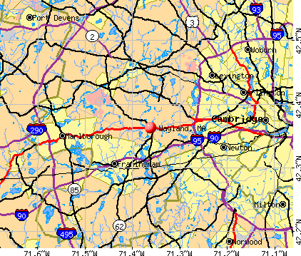
- OSM Map
- General Map
- Google Map
- MSN Map
Population change since 2000: -0.8%
 |
| Males: 6,271 | |
| Females: 6,723 |
| Median resident age: | 45.4 years |
| Massachusetts median age: | 39.2 years |
Zip codes: 01778.
| Wayland: | $197,351 |
| MA: | $94,488 |
Estimated per capita income in 2022: $109,450 (it was $52,717 in 2000)
Wayland town income, earnings, and wages data
Estimated median house or condo value in 2022: over $1,000,000 (it was $388,600 in 2000)
| Wayland: | over $1,000,000 |
| MA: | $534,700 |
Mean prices in 2022: all housing units: $796,617; detached houses: $834,667; townhouses or other attached units: $772,440; in 2-unit structures: $786,250; in 3-to-4-unit structures: $655,835; in 5-or-more-unit structures: $590,321; mobile homes: $144,935
Detailed information about poverty and poor residents in Wayland, MA


Compare current foreclosures near Wayland, MA:


- 11,08285.3%White alone
- 1,2849.9%Asian alone
- 3152.4%Hispanic
- 1851.4%Two or more races
- 1010.8%Black alone
- 210.2%Other race alone
- 40.03%American Indian alone
- 20.02%Native Hawaiian and Other
Pacific Islander alone
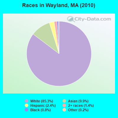
Races in Wayland detailed stats: ancestries, foreign born residents, place of birth
Type |
2009 |
2010 |
2011 |
2012 |
2013 |
2014 |
2015 |
2016 |
2017 |
2018 |
2019 |
2020 |
2022 |
|---|---|---|---|---|---|---|---|---|---|---|---|---|---|
| Murders (per 100,000) | 0 (0.0) | 0 (0.0) | 1 (7.6) | 0 (0.0) | 0 (0.0) | 0 (0.0) | 0 (0.0) | 0 (0.0) | 0 (0.0) | 0 (0.0) | 0 (0.0) | 0 (0.0) | 0 (0.0) |
| Rapes (per 100,000) | 0 (0.0) | 0 (0.0) | 0 (0.0) | 0 (0.0) | 0 (0.0) | 0 (0.0) | 0 (0.0) | 0 (0.0) | 0 (0.0) | 0 (0.0) | 0 (0.0) | 0 (0.0) | 0 (0.0) |
| Robberies (per 100,000) | 3 (22.7) | 1 (7.7) | 0 (0.0) | 1 (7.5) | 0 (0.0) | 2 (14.7) | 0 (0.0) | 2 (14.5) | 0 (0.0) | 0 (0.0) | 0 (0.0) | 0 (0.0) | 0 (0.0) |
| Assaults (per 100,000) | 1 (7.6) | 3 (23.1) | 1 (7.6) | 7 (52.8) | 5 (37.3) | 4 (29.4) | 1 (7.3) | 3 (21.8) | 2 (14.3) | 1 (7.1) | 0 (0.0) | 1 (7.2) | 1 (7.4) |
| Burglaries (per 100,000) | 6 (45.5) | 16 (123.1) | 6 (45.9) | 17 (128.3) | 16 (119.3) | 7 (51.5) | 4 (29.2) | 4 (29.1) | 5 (35.8) | 0 (0.0) | 1 (7.2) | 0 (0.0) | 0 (0.0) |
| Thefts (per 100,000) | 23 (174.3) | 21 (161.6) | 21 (160.6) | 29 (218.9) | 24 (179.0) | 6 (44.1) | 4 (29.2) | 1 (7.3) | 1 (7.2) | 1 (7.1) | 0 (0.0) | 0 (0.0) | 21 (154.4) |
| Auto thefts (per 100,000) | 4 (30.3) | 0 (0.0) | 1 (7.6) | 4 (30.2) | 2 (14.9) | 1 (7.4) | 0 (0.0) | 1 (7.3) | 3 (21.5) | 0 (0.0) | 0 (0.0) | 0 (0.0) | 2 (14.7) |
| Arson (per 100,000) | 0 (0.0) | 0 (0.0) | 1 (7.6) | 0 (0.0) | 0 (0.0) | 0 (0.0) | 0 (0.0) | 0 (0.0) | 0 (0.0) | 0 (0.0) | 0 (0.0) | 0 (0.0) | 0 (0.0) |
| City-Data.com crime index | 20.9 | 22.0 | 27.1 | 33.0 | 24.2 | 16.3 | 4.7 | 11.6 | 7.4 | 1.7 | 0.5 | 1.4 | 8.8 |
The City-Data.com crime index weighs serious crimes and violent crimes more heavily. Higher means more crime, U.S. average is 246.1. It adjusts for the number of visitors and daily workers commuting into cities.
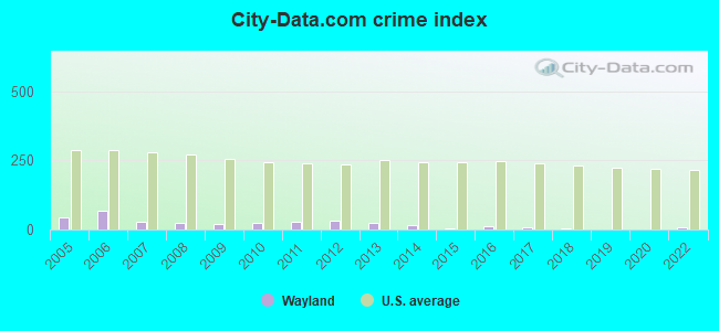
Crime rate in Wayland detailed stats: murders, rapes, robberies, assaults, burglaries, thefts, arson
Full-time law enforcement employees in 2021, including police officers: 24 (23 officers - 19 male; 4 female).
| Officers per 1,000 residents here: | 1.65 |
| Massachusetts average: | 2.53 |
 Recent articles from our blog. Our writers, many of them Ph.D. graduates or candidates, create easy-to-read articles on a wide variety of topics.

 | Lexington, Concord, Lincoln, Wayland, Sudbury, Weston? (83 replies) |
| Natick, Wayland, or Sudbury? (30 replies) |
| Affordable housing right across the street? (Wayland) (15 replies) |
| Best Town to live in based on Public Schools (58 replies) |
| Concord, Acton, Sudbury, Wayland for young families? (79 replies) |
| Towns within 495 with nice walkable downtowns and good schools (205 replies) |
Latest news from Wayland, MA collected exclusively by city-data.com from local newspapers, TV, and radio stations
Ancestries: Irish (19.3%), English (15.7%), Italian (15.0%), German (10.9%), Russian (7.0%), Polish (5.4%).
Current Local Time: EST time zone
Incorporated in 1780
Elevation: 127 feet
Land area: 15.2 square miles.
Population density: 853 people per square mile (low).
1,161 residents are foreign born (3.9% Europe, 3.2% Asia).
| This town: | 8.9% |
| Massachusetts: | 12.2% |
| Wayland town: | 1.4% ($5,408) |
| Massachusetts: | 1.3% ($2,336) |
Nearest city with pop. 50,000+: Framingham, MA  (4.8 miles , pop. 66,910).
Nearest city with pop. 200,000+: Boston, MA (13.8 miles , pop. 589,141).
Nearest city with pop. 1,000,000+: Bronx, NY (166.4 miles , pop. 1,332,650).
Nearest cities:
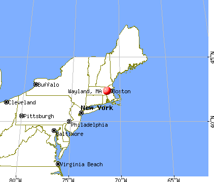
), ), ), Latitude: 42.35 N, Longitude: 71.36 W
Area codes: 508, 774
Wayland, Massachusetts accommodation & food services, waste management - Economy and Business Data
Single-family new house construction building permits:
- 2022: 1 building, cost: $500,000
- 2021: 6 buildings, average cost: $421,700
- 2020: 10 buildings, average cost: $406,600
- 2019: 3 buildings, average cost: $550,100
- 2018: 18 buildings, average cost: $489,800
- 2017: 13 buildings, average cost: $546,800
- 2016: 21 buildings, average cost: $326,600
- 2015: 26 buildings, average cost: $302,900
- 2014: 29 buildings, average cost: $345,900
- 2013: 15 buildings, average cost: $300,700
- 2012: 33 buildings, average cost: $320,300
- 2011: 17 buildings, average cost: $359,000
- 2010: 13 buildings, average cost: $256,500
- 2009: 9 buildings, average cost: $374,600
- 2008: 5 buildings, average cost: $314,100
- 2007: 17 buildings, average cost: $372,700
- 2006: 23 buildings, average cost: $524,200
- 2005: 20 buildings, average cost: $864,900
- 2004: 28 buildings, average cost: $344,500
- 2003: 10 buildings, average cost: $356,100
- 2002: 16 buildings, average cost: $322,100
- 2001: 25 buildings, average cost: $333,700
- 2000: 42 buildings, average cost: $338,800
- 1999: 56 buildings, average cost: $266,800
- 1998: 54 buildings, average cost: $202,200
- 1997: 43 buildings, average cost: $187,500
| Here: | 3.0% |
| Massachusetts: | 3.5% |
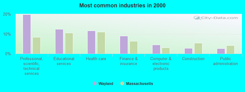
- Professional, scientific, technical services (19.8%)
- Educational services (12.4%)
- Health care (11.6%)
- Finance & insurance (8.9%)
- Computer & electronic products (4.5%)
- Construction (2.8%)
- Public administration (2.7%)
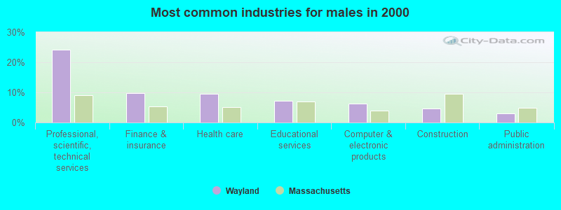
- Professional, scientific, technical services (24.1%)
- Finance & insurance (9.8%)
- Health care (9.5%)
- Educational services (7.2%)
- Computer & electronic products (6.4%)
- Construction (4.7%)
- Public administration (3.1%)
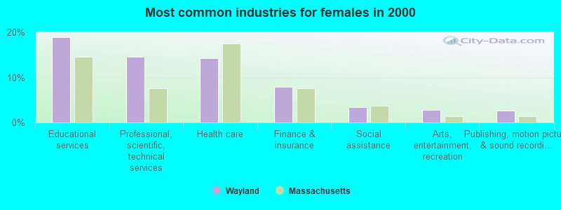
- Educational services (18.9%)
- Professional, scientific, technical services (14.5%)
- Health care (14.2%)
- Finance & insurance (7.9%)
- Social assistance (3.4%)
- Arts, entertainment, recreation (2.8%)
- Publishing, motion picture & sound recording industries (2.6%)
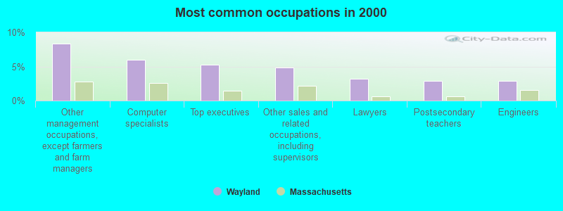
- Other management occupations, except farmers and farm managers (8.3%)
- Computer specialists (6.0%)
- Top executives (5.3%)
- Other sales and related occupations, including supervisors (4.9%)
- Lawyers (3.2%)
- Postsecondary teachers (2.9%)
- Engineers (2.9%)

- Other management occupations, except farmers and farm managers (9.8%)
- Top executives (7.8%)
- Computer specialists (7.6%)
- Other sales and related occupations, including supervisors (5.5%)
- Engineers (5.0%)
- Physicians and surgeons (4.0%)
- Postsecondary teachers (3.6%)

- Other management occupations, except farmers and farm managers (6.5%)
- Secretaries and administrative assistants (6.1%)
- Registered nurses (4.1%)
- Preschool, kindergarten, elementary, and middle school teachers (4.0%)
- Other sales and related occupations, including supervisors (4.0%)
- Computer specialists (3.9%)
- Counselors, social workers, and other community and social service specialists (3.8%)
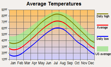
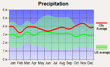
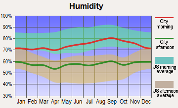
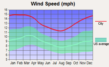
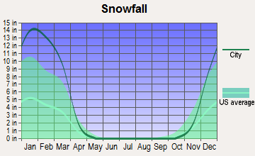
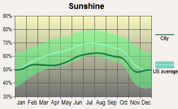
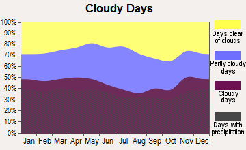
Average climate in Wayland, Massachusetts
Based on data reported by over 4,000 weather stations
(lower is better)
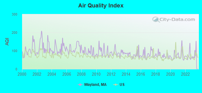
Air Quality Index (AQI) level in 2022 was 73.1. This is about average.
| City: | 73.1 |
| U.S.: | 72.6 |
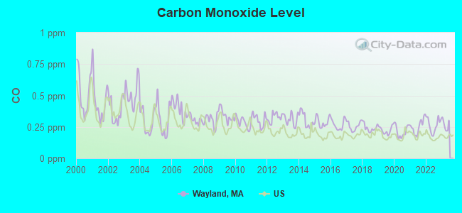
Carbon Monoxide (CO) [ppm] level in 2022 was 0.265. This is about average. Closest monitor was 6.5 miles away from the city center.
| City: | 0.265 |
| U.S.: | 0.251 |
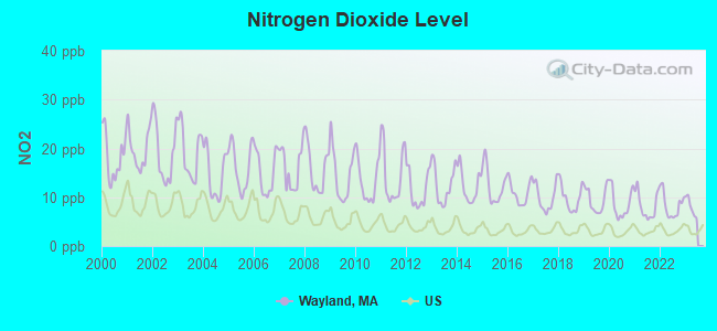
Nitrogen Dioxide (NO2) [ppb] level in 2022 was 8.29. This is significantly worse than average. Closest monitor was 4.5 miles away from the city center.
| City: | 8.29 |
| U.S.: | 5.11 |
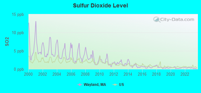
Sulfur Dioxide (SO2) [ppb] level in 2022 was 0.362. This is significantly better than average. Closest monitor was 4.5 miles away from the city center.
| City: | 0.362 |
| U.S.: | 1.515 |
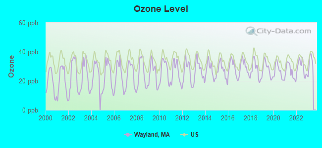
Ozone [ppb] level in 2022 was 29.0. This is about average. Closest monitor was 4.4 miles away from the city center.
| City: | 29.0 |
| U.S.: | 33.3 |
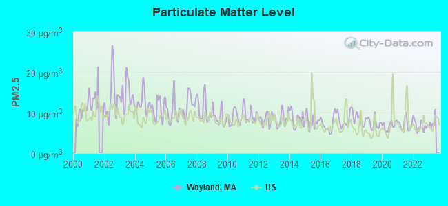
Particulate Matter (PM2.5) [µg/m3] level in 2022 was 6.83. This is about average. Closest monitor was 8.0 miles away from the city center.
| City: | 6.83 |
| U.S.: | 8.11 |
Tornado activity:
Wayland-area historical tornado activity is near Massachusetts state average. It is 34% smaller than the overall U.S. average.
On 6/9/1953, a category F4 (max. wind speeds 207-260 mph) tornado 8.9 miles away from the Wayland town center killed 90 people and injured 1228 people and caused between $50,000,000 and $500,000,000 in damages.
On 10/3/1970, a category F3 (max. wind speeds 158-206 mph) tornado 17.6 miles away from the town center killed one person and caused between $50,000 and $500,000 in damages.
Earthquake activity:
Wayland-area historical earthquake activity is significantly above Massachusetts state average. It is 73% smaller than the overall U.S. average.On 10/7/1983 at 10:18:46, a magnitude 5.3 (5.1 MB, 5.3 LG, 5.1 ML, Class: Moderate, Intensity: VI - VII) earthquake occurred 187.2 miles away from Wayland center
On 4/20/2002 at 10:50:47, a magnitude 5.3 (5.3 ML, Depth: 3.0 mi) earthquake occurred 190.5 miles away from Wayland center
On 1/19/1982 at 00:14:42, a magnitude 4.7 (4.5 MB, 4.7 MD, 4.5 LG, Class: Light, Intensity: IV - V) earthquake occurred 80.8 miles away from Wayland center
On 4/20/2002 at 10:50:47, a magnitude 5.2 (5.2 MB, 4.2 MS, 5.2 MW, 5.0 MW) earthquake occurred 189.8 miles away from the city center
On 10/16/2012 at 23:12:25, a magnitude 4.7 (4.7 ML, Depth: 10.0 mi) earthquake occurred 93.6 miles away from the city center
On 8/22/1992 at 12:20:32, a magnitude 4.8 (4.8 MB, 3.8 MS, 4.7 LG, Depth: 6.2 mi) earthquake occurred 230.6 miles away from the city center
Magnitude types: regional Lg-wave magnitude (LG), body-wave magnitude (MB), duration magnitude (MD), local magnitude (ML), surface-wave magnitude (MS), moment magnitude (MW)
Natural disasters:
The number of natural disasters in Middlesex County (31) is a lot greater than the US average (15).Major Disasters (Presidential) Declared: 17
Emergencies Declared: 14
Causes of natural disasters: Floods: 12, Storms: 9, Hurricanes: 6, Snowstorms: 6, Winter Storms: 5, Blizzards: 2, Snows: 2, Explosion: 1, Heavy Rain: 1, Snowfall: 1, Water Main Break: 1, Wind: 1 (Note: some incidents may be assigned to more than one category).

Main business address for: MOLDFLOW CORP (SERVICES-PREPACKAGED SOFTWARE), CANDELA CORP /DE/ (ELECTROMEDICAL & ELECTROTHERAPEUTIC APPARATUS), NATIONAL DENTEX CORP /MA/ (SERVICES-HEALTH SERVICES).
Hospitals and medical centers in Wayland:
Amtrak stations near Wayland:
- 6 miles: FRAMINGHAM (443 WAVERLY ST.) . Services: public payphones, snack bar, paid short-term parking, taxi stand, public transit connection.
- 15 miles: ROUTE 128 (WESTWOOD, UNIVERSITY AVE. & RTE. 128) . Services: ticket office, enclosed waiting area, public restrooms, public payphones, vending machines, paid short-term parking, taxi stand, public transit connection.
- 15 miles: BACK BAY (BOSTON, 145 DARTMOUTH ST.) . Services: ticket office, partially wheelchair accessible, enclosed waiting area, public restrooms, public payphones, vending machines, ATM, paid short-term parking, paid long-term parking, call for car rental service, taxi stand, public transit connection.
Colleges/universities with over 2000 students nearest to Wayland:
- Wellesley College (about 5 miles; Wellesley, MA; Full-time enrollment: 2,658)
- Massachusetts Bay Community College (about 6 miles; Wellesley Hills, MA; FT enrollment: 3,636)
- Framingham State University (about 6 miles; Framingham, MA; FT enrollment: 5,743)
- Brandeis University (about 6 miles; Waltham, MA; FT enrollment: 6,966)
- Babson College (about 6 miles; Wellesley, MA; FT enrollment: 3,230)
- Bentley University (about 8 miles; Waltham, MA; FT enrollment: 5,229)
- Boston College (about 10 miles; Chestnut Hill, MA; FT enrollment: 12,070)
Public high school in Wayland:
- WAYLAND HIGH SCHOOL (Students: 919, Location: 264 OLD CONNECTICUT PATH, Grades: 9-12)
Public elementary/middle schools in Wayland:
- WAYLAND MIDDLE SCHOOL (Students: 720, Location: 201 MAIN STREET, Grades: 6-8)
- CLAYPIT HILL SCHOOL (Students: 522, Location: 40 ADAMS LANE, Grades: KG-5)
- LOKER SCHOOL (Students: 363, Location: 47 LOKER STREET, Grades: KG-4)
- HAPPY HOLLOW SCHOOL (Students: 350, Location: 63 PEQUOT RD, Grades: KG-5)
Library in Wayland:
Points of interest:
Notable locations in Wayland: Sandy Burr Country Club (A), Wayland Country Club (B), Commonwealth Shopper (C), Wayland Fire Department Station 2 (D), Fogg Art Museum (E), Wayland Fire Department Station 1 Headquarters (F), Temple Shir Tikva Library (G), Happy Hollow Elementary Library (H), Loker Elementary School Library Media Center (I), Wayland Free Public Library (J). Display/hide their locations on the map
Shopping Centers: Wayland Shopping Center (1), Cochituate Center Shopping Center (2). Display/hide their locations on the map
Main business address in Wayland include: MOLDFLOW CORP (A), CANDELA CORP /DE/ (B), NATIONAL DENTEX CORP /MA/ (C). Display/hide their locations on the map
Churches in Wayland include: Saint Anns Church (A), Peace Church (B), Church of the Holy Spirit (C). Display/hide their locations on the map
Cemeteries: North Cemetery (1), South Cemetery (2), Lakeview Cemetery (3), Saint Zephryns Cemetery (4). Display/hide their locations on the map
Lakes, reservoirs, and swamps: Heard Pond (A), Folsom Pond (B), Baldwin Pond (C), Dudley Pond (D), Mill Pond (E), Old Wayland Reservoirs (F), Lake Cochituate (G), Sedge Meadows (H). Display/hide their locations on the map
Streams, rivers, and creeks: Wash Brook (A), Hazel Brook (B), Hayward Brook (C), Snake Brook (D), Pine Brook (E), Mill Brook (F). Display/hide their locations on the map
Parks in Wayland include: Wayland Center Historic District (1), Cat Rock Park (2), Cochituate State Park (3). Display/hide their locations on the map
Tourist attraction: BidBot Technologies (Tours & Charters; 16 Boston Post Road) (1). Display/hide its approximate location on the map
Hotels: Pompano Beach Club (36 Pompano Beach Road) (1), Bermuda Hotel Representatives (231 Boston Post Rd) (2). Display/hide their approximate locations on the map
Birthplace of: Lydia Child - (born 1802), author, Frank Leary - Major League Baseball pitcher, Ned Burke - Football player and coach.
Drinking water stations with addresses in Wayland and their reported violations in the past:
WAYLAND WATER DEPARTMENT (Population served: 13,913, Groundwater):Past health violations:SANDY BOTTOM ESTATES MHP (Serves ME, Population served: 124, Groundwater):Past monitoring violations:
- MCL, Monthly (TCR) - In AUG-2012, Contaminant: Coliform. Follow-up actions: St AO (w/o penalty) issued (SEP-17-2012)
- MCL, Monthly (TCR) - In AUG-2011, Contaminant: Coliform. Follow-up actions: St AO (w/o penalty) issued (SEP-26-2011)
- MCL, Acute (TCR) - In OCT-2005, Contaminant: Coliform. Follow-up actions: St AO (w/penalty) issued (DEC-16-2005)
- MCL, Monthly (TCR) - In SEP-2005, Contaminant: Coliform. Follow-up actions: St AO (w/penalty) issued (DEC-16-2005)
- Follow-up Or Routine LCR Tap M/R - In OCT-01-2005, Contaminant: Lead and Copper Rule. Follow-up actions: St AO (w/o penalty) issued (JAN-23-2006), St AO (w/penalty) issued (FEB-27-2007), St Compliance achieved (OCT-02-2007), St AO (w/o penalty) issued (JAN-07-2008), St Compliance achieved (JAN-10-2009)
- 2 regular monitoring violations
Past health violations:HWVCA WELL-HISTORIC WAITSFIELD HOUSE (Address: 304 CONCORD ROAD , Serves VT, Population served: 91, Groundwater):Past monitoring violations:
- MCL, Monthly (TCR) - In DEC-2011, Contaminant: Coliform. Follow-up actions: St Public Notif requested (JAN-13-2012), St Formal NOV issued (JAN-13-2012), St Public Notif received (FEB-08-2012), St Compliance achieved (FEB-21-2012)
- MCL, Monthly (TCR) - In OCT-2005, Contaminant: Coliform. Follow-up actions: St Violation/Reminder Notice (2 times from NOV-09-2005 to NOV-09-2005), St Public Notif requested (2 times from NOV-09-2005 to NOV-09-2005), St Tech Assistance Visit (NOV-09-2005), St Boil Water Order (NOV-09-2005), St Compliance achieved (DEC-05-2005), St Intentional no-action (AUG-19-2011)
- One routine major monitoring violation
Past health violations:Past monitoring violations:
- MCL, Monthly (TCR) - In JUL-2007, Contaminant: Coliform. Follow-up actions: St Tech Assistance Visit (JUL-31-2007), St Formal NOV issued (JUL-31-2007), St Boil Water Order (JUL-31-2007), St Public Notif requested (JUL-31-2007), St Public Notif received (AUG-07-2007), St Compliance achieved (SEP-25-2009)
- MCL, Monthly (TCR) - In JUN-2007, Contaminant: Coliform. Follow-up actions: St Tech Assistance Visit (JUN-15-2007), St Formal NOV issued (JUN-15-2007), St Boil Water Order (JUN-15-2007), St Public Notif requested (JUN-15-2007), St Public Notif received (JUL-30-2007), St Compliance achieved (SEP-25-2009)
- MCL, Monthly (TCR) - In SEP-2006, Contaminant: Coliform. Follow-up actions: St Formal NOV issued (OCT-03-2006), St Public Notif requested (OCT-03-2006), St Public Notif received (NOV-09-2006), St Compliance achieved (SEP-25-2009)
- MCL, Monthly (TCR) - In AUG-2006, Contaminant: Coliform. Follow-up actions: St Formal NOV issued (AUG-28-2006), St Boil Water Order (AUG-28-2006), St Tech Assistance Visit (AUG-28-2006), St Public Notif requested (AUG-28-2006), St Public Notif received (NOV-09-2006), St Compliance achieved (SEP-25-2009)
- Initial Tap Sampling for Pb and Cu - In JUL-01-2007, Contaminant: Lead and Copper Rule. Follow-up actions: St Public Notif requested (AUG-22-2007), St Formal NOV issued (AUG-22-2007), St Other (AUG-22-2007), St Compliance achieved (OCT-08-2007)
- Monitoring, Repeat Major (TCR) - Between JAN-2007 and MAR-2007, Contaminant: Coliform (TCR). Follow-up actions: St Formal NOV issued (APR-16-2007), St Public Notif requested (APR-16-2007), St Public Notif received (APR-26-2007), St Compliance achieved (SEP-25-2009)
- 2 minor monitoring violations
- 2 regular monitoring violations
| This town: | 2.7 people |
| Massachusetts: | 2.5 people |
| This town: | 76.5% |
| Whole state: | 63.0% |
| This town: | 3.2% |
| Whole state: | 7.0% |
Likely homosexual households (counted as self-reported same-sex unmarried-partner households)
- Lesbian couples: 0.3% of all households
- Gay men: 0.2% of all households
| This town: | 2.5% |
| Whole state: | 9.3% |
| This town: | 1.1% |
| Whole state: | 4.4% |
153 people in nursing homes in 2000
7 people in other nonhousehold living situations in 2000
Banks with branches in Wayland (2011 data):
- TD Bank, National Association: Wayland Store Branch at 57 Main Street, branch established on 2010/01/16; Wayland 54 Boston Post Road Store at 54 Boston Post Road, branch established on 2011/10/15. Info updated 2010/10/04: Bank assets: $188,912.6 mil, Deposits: $153,149.8 mil, headquarters in Wilmington, DE, positive income, 1314 total offices, Holding Company: Toronto-Dominion Bank, The
- Bank of America, National Association: Wayland Branch at 289 Boston Post Road, branch established on 1959/10/27; Cochituate Branch at 179 Commonwealth Road, branch established on 1954/12/13. Info updated 2009/11/18: Bank assets: $1,451,969.3 mil, Deposits: $1,077,176.8 mil, headquarters in Charlotte, NC, positive income, 5782 total offices, Holding Company: Bank Of America Corporation
- Sovereign Bank, National Association: Wayland Branch at 326 Boston Post Road, branch established on 1956/08/01. Info updated 2012/01/31: Bank assets: $78,146.9 mil, Deposits: $48,042.9 mil, headquarters in Wilmington, DE, positive income, Commercial Lending Specialization, 718 total offices, Holding Company: Banco Santander, S.A.
- The Village Bank: Wayland Branch at 62 Boston Post Road, branch established on 1977/09/01. Info updated 2006/11/03: Bank assets: $705.4 mil, Deposits: $601.9 mil, headquarters in Auburndale, MA, positive income, 8 total offices
For population 15 years and over in Wayland:
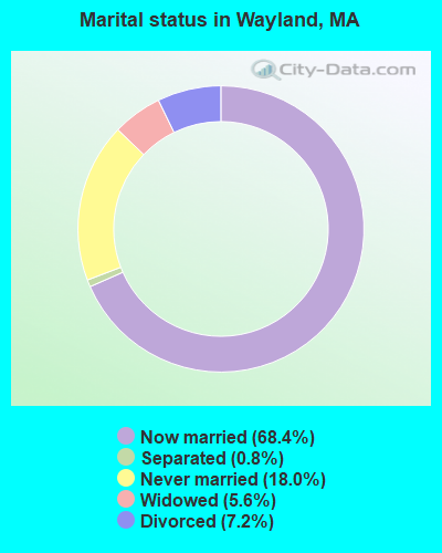
- Never married: 18.0%
- Now married: 68.4%
- Separated: 0.8%
- Widowed: 5.6%
- Divorced: 7.2%
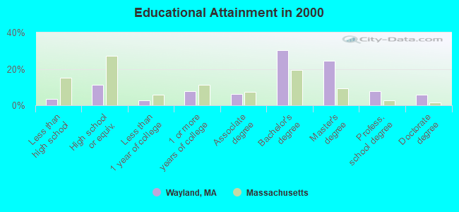
For population 25 years and over in Wayland:
- High school or higher: 96.5%
- Bachelor's degree or higher: 68.3%
- Graduate or professional degree: 37.9%
- Unemployed: 2.0%
- Mean travel time to work (commute): 31.3 minutes
| Here: | 10.0 |
| Massachusetts average: | 13.1 |


Graphs represent county-level data. Detailed 2008 Election Results
Religion statistics for Wayland, MA (based on Middlesex County data)


| Religion | Adherents | Congregations |
|---|---|---|
| Catholic | 718,209 | 107 |
| Mainline Protestant | 70,053 | 269 |
| Other | 68,480 | 199 |
| Evangelical Protestant | 41,270 | 304 |
| Orthodox | 23,641 | 28 |
| Black Protestant | 2,276 | 8 |
| None | 579,156 | - |
Food Environment Statistics:
| Middlesex County: | 1.71 / 10,000 pop. |
| Massachusetts: | 1.98 / 10,000 pop. |
| This county: | 0.03 / 10,000 pop. |
| State: | 0.05 / 10,000 pop. |
| Middlesex County: | 2.14 / 10,000 pop. |
| Massachusetts: | 2.22 / 10,000 pop. |
| Here: | 1.38 / 10,000 pop. |
| Massachusetts: | 1.77 / 10,000 pop. |
| Here: | 7.84 / 10,000 pop. |
| Massachusetts: | 8.76 / 10,000 pop. |
| Middlesex County: | 7.8% |
| State: | 8.1% |
| This county: | 21.5% |
| State: | 22.5% |
| Here: | 18.0% |
| Massachusetts: | 16.5% |
6.91% of this county's 2021 resident taxpayers lived in other counties in 2020 ($102,955 average adjusted gross income)
| Here: | 6.91% |
| Massachusetts average: | 6.35% |
0.01% of residents moved from foreign countries ($137 average AGI)
Middlesex County: 0.01% Massachusetts average: 0.01%
Top counties from which taxpayers relocated into this county between 2020 and 2021:
| from Suffolk County, MA | |
| from Essex County, MA | |
| from Norfolk County, MA |
8.22% of this county's 2020 resident taxpayers moved to other counties in 2021 ($123,369 average adjusted gross income)
| Here: | 8.22% |
| Massachusetts average: | 7.18% |
0.01% of residents moved to foreign countries ($124 average AGI)
Middlesex County: 0.01% Massachusetts average: 0.02%
Top counties to which taxpayers relocated from this county between 2020 and 2021:
| to Suffolk County, MA | |
| to Essex County, MA | |
| to Worcester County, MA |
| Businesses in Wayland, MA | ||||
| Name | Count | Name | Count | |
|---|---|---|---|---|
| Bentleymotors.Com | 1 | Jones New York | 1 | |
| CVS | 1 | Rite Aid | 1 | |
| DHL | 1 | Starbucks | 1 | |
| Domino's Pizza | 1 | Stop & Shop | 1 | |
| Dunkin Donuts | 1 | UPS | 1 | |
| FedEx | 3 | Whole Foods Market | 1 | |
Strongest AM radio stations in Wayland:
- WKOX (1200 AM; 50 kW; FRAMINGHAM, MA; Owner: CAPSTAR TX LIMITED PARTNERSHIP)
- WEEI (850 AM; 50 kW; BOSTON, MA; Owner: ENTERCOM BOSTON LICENSE, LLC)
- WBIX (1060 AM; 40 kW; NATICK, MA; Owner: LANGER BROADCASTING CORPORATION)
- WRCA (1330 AM; 25 kW; WALTHAM, MA; Owner: WRCA LICENSE, LLC)
- WWZN (1510 AM; 50 kW; BOSTON, MA; Owner: ROSE CITY RADIO CORPORATION)
- WAMG (890 AM; 25 kW; DEDHAM, MA; Owner: MEGA COMMUNICATIONS OF DEDHAM LICENSEE, LLC)
- WRKO (680 AM; 50 kW; BOSTON, MA; Owner: ENTERCOM BOSTON LICENSE, LLC)
- WNTN (1550 AM; 10 kW; NEWTON, MA; Owner: COLT COMMUNICATIONS, LLC)
- WUNR (1600 AM; 20 kW; BROOKLINE, MA; Owner: CHAMPION BROADCASTING SYSTEMS, INC.)
- WBZ (1030 AM; 50 kW; BOSTON, MA; Owner: INFINITY BROADCASTING OPERATIONS, INC.)
- WBNW (1120 AM; 5 kW; CONCORD, MA; Owner: MONEY MATTERS RADIO, INC.)
- WCRN (830 AM; 50 kW; WORCESTER, MA; Owner: CARTER BROADCASTING CORPORATION)
- WALE (990 AM; 50 kW; GREENVILLE, RI; Owner: NORTH AMERICAN BROADCASTING CO., INC.)
Strongest FM radio stations in Wayland:
- WGBH (89.7 FM; BOSTON, MA; Owner: WGBH EDUCATIONAL FOUNDATION)
- WBMX (98.5 FM; BOSTON, MA; Owner: INFINITY RADIO OPERATIONS INC.)
- WJMN (94.5 FM; BOSTON, MA; Owner: AMFM RADIO LICENSES, L.L.C.)
- WCRB (102.5 FM; WALTHAM, MA; Owner: CHARLES RIVER BROADCASTING WCRB LICE)
- WTKK (96.9 FM; BOSTON, MA; Owner: GREATER BOSTON RADIO, INC.)
- WROR-FM (105.7 FM; FRAMINGHAM, MA; Owner: GREATER BOSTON RADIO, INC.)
- WBOS (92.9 FM; BROOKLINE, MA; Owner: GREATER BOSTON RADIO, INC.)
- WBUR-FM (90.9 FM; BOSTON, MA; Owner: TRUSTEES OF BOSTON UNIVERSITY)
- WODS (103.3 FM; BOSTON, MA; Owner: INFINITY BROADCASTING OPERATIONS, INC.)
- WYAJ (97.7 FM; SUDBURY, MA; Owner: SUDBURY VALLEY B'CASTING FOUNDATION)
- WXKS-FM (107.9 FM; MEDFORD, MA; Owner: AMFM RADIO LICENSES, L.L.C.)
- WMJX (106.7 FM; BOSTON, MA; Owner: GREATER BOSTON RADIO, INC.)
- WBCN (104.1 FM; BOSTON, MA; Owner: HEMISPHERE BROADCASTING CORPORATION)
- WZLX (100.7 FM; BOSTON, MA; Owner: INFINITY BROADCASTING CORPORATION OF BOSTON)
- W267AI (101.3 FM; BOSTON, MA; Owner: MCC BROADCASTING COMPANY, INC.)
- WERS (88.9 FM; BOSTON, MA; Owner: EMERSON COLLEGE)
- WZLY (91.5 FM; WELLESLEY, MA; Owner: WELLESLEY COLLEGE)
- WBRS (100.1 FM; WALTHAM, MA; Owner: BRANDEIS UNIVERSITY)
- WHRB (95.3 FM; CAMBRIDGE, MA; Owner: HARVARD RADIO BROADCASTING CO., INC.)
- WAAF (107.3 FM; WORCESTER, MA; Owner: ENTERCOM BOSTON LICENSE, LLC)
TV broadcast stations around Wayland:
- WCVB-TV (Channel 5; BOSTON, MA; Owner: WCVB HEARST-ARGYLE TV, INC.)
- WGBH-TV (Channel 2; BOSTON, MA; Owner: WGBH EDUCATIONAL FOUNDATION)
- WBZ-TV (Channel 4; BOSTON, MA; Owner: VIACOM INC.)
- WGBX-TV (Channel 44; BOSTON, MA; Owner: WGBH EDUCATIONAL FOUNDATION)
- WMFP (Channel 62; LAWRENCE, MA; Owner: WSAH LICENSE, INC.)
- WHDH-TV (Channel 7; BOSTON, MA; Owner: WHDH-TV)
- WSBK-TV (Channel 38; BOSTON, MA; Owner: VIACOM INC.)
- WLVI-TV (Channel 56; CAMBRIDGE, MA; Owner: WLVI, INC.)
- WUTF (Channel 66; MARLBOROUGH, MA; Owner: TELEFUTURA BOSTON LLC)
- WFXT (Channel 25; BOSTON, MA; Owner: FOX TELEVISION STATIONS INC.)
- W40BO (Channel 40; BOSTON, MA; Owner: PAXSON COMMUNICATIONS LPTV, INC.)
- WBPX (Channel 68; BOSTON, MA; Owner: PAXSON BOSTON-68 LICENSE, INC.)
- WUNI (Channel 27; WORCESTER, MA; Owner: ENTRAVISION HOLDINGS, LLC)
- WTMU-LP (Channel 32; BOSTON, MA; Owner: ZGS BOSTON, INC.)
- WCEA-LP (Channel 58; BOSTON, MA; Owner: CHANNEL 19 TV CORPORATION)
- WWDP (Channel 46; NORWELL, MA; Owner: NORWELL TELEVISION, LLC)
- WFXZ-CA (Channel 24; BOSTON, MA; Owner: BOSTON BROADCASTING CORP.)
- WNAC-TV (Channel 64; PROVIDENCE, RI; Owner: WNAC, LLC)
- WPRI-TV (Channel 12; PROVIDENCE, RI; Owner: TVL BROADCASTING OF RHODE ISLAND, LLC)
- WLNE-TV (Channel 6; NEW BEDFORD, MA; Owner: FREEDOM BROADCASTING OF SOUTHERN NEW ENGLAND, INC.)
- WJAR (Channel 10; PROVIDENCE, RI; Owner: OUTLET BROADCASTING, INC.)
- WYDN (Channel 48; WORCESTER, MA; Owner: EDUCATIONAL PUBLIC TV CORPORATION)
- WSBE-TV (Channel 36; PROVIDENCE, RI; Owner: RHODE ISLAND PUBLIC TELECOM. AUTHORITY)
- WPXQ (Channel 69; BLOCK ISLAND, RI; Owner: OCEAN STATE TELEVISION, L.L.C.)
- WNDS (Channel 50; DERRY, NH; Owner: CTV OF DERRY, INC)
- National Bridge Inventory (NBI) Statistics
- 6Number of bridges
- 52ft / 15.6mTotal length
- $13,157,000Total costs
- 259,364Total average daily traffic
- 9,551Total average daily truck traffic
FCC Registered Antenna Towers:
2- EDWARD T MOORE, 139 Old Connecticut Path (Lat: 42.348444 Lon: -71.351417), Type: 54.5, Overall height: 54.5 m, Registrant: Glover Property Management, Inc., Tedmoore@gloverproperty.Com, , Marbl-ehead, Phone: (781) 639-1113
- EDWARD T MOORE, 139 Old Connecticut Path (Lat: 42.348444 Lon: -71.351417), Type: 54.5, Overall height: 54.5 m, Registrant: Glover Property Management, Inc., Tedmoore@gloverproperty.Com, , Marbl-ehead, Phone: (781) 639-1113
FCC Registered Broadcast Land Mobile Towers:
9 (See the full list of FCC Registered Broadcast Land Mobile Towers in Wayland, MA)FCC Registered Microwave Towers:
6- Various Locations (Lat: 42.316750 Lon: -71.332833), Overall height: 2.4 m, Call Sign: WPOP633,
Assigned Frequencies: 956.343 MHz, Grant Date: 08/07/2018, Expiration Date: 08/14/2028, Registrant: Town Of Wayland Water Department, 66 River Road, Wayland, MA 01778, Phone: (508) 358-3672, Email:
- WAYLAND, Lat: 42.346944 Lon: -71.354028, Call Sign: WQLA970,
Assigned Frequencies: 956.343 MHz, Grant Date: 11/17/2009, Expiration Date: 11/17/2019, Cancellation Date: 01/18/2020, Certifier: Judy Whalen, Registrant: Sensus, 450 N Gallatin Avenue, Uniontown, PA 15401, Phone: (800) 638-3748, Fax: (800) 888-2403, Email:
- MA-BOS7237D, 139 Old Connecticut Path (Lat: 42.348444 Lon: -71.351417), Type: Pole, Structure height: 54.5 m, Call Sign: WQMB450,
Assigned Frequencies: 17815.0 MHz, 17915.0 MHz, Grant Date: 08/04/2020, Expiration Date: 06/17/2030, Cancellation Date: 09/13/2021, Certifier: Nadja S Sodos-Wallace, Registrant: T-Mobile Usa, Inc., 12920 Se 38th Street, Bellevue, WA 98006, Phone: (425) 383-8402, Fax: (425) 383-4840, Email:
- MA-BOS7237D, 139 Old Connecticut Path (Lat: 42.348472 Lon: -71.351278), Type: Pole, Structure height: 54.5 m, Call Sign: WQMP961,
Assigned Frequencies: 11265.0 MHz, 11425.0 MHz, Grant Date: 11/03/2020, Expiration Date: 10/19/2030, Cancellation Date: 09/14/2021, Certifier: Nadja S Sodos-Wallace, Registrant: T-Mobile Usa, Inc., 12920 Se 38th Street, Bellevue, WA 98006, Phone: (425) 383-8402, Fax: (425) 383-4840, Email:
- Wayland PD/FD, 38 Cochituate Road (Lat: 42.363611 Lon: -71.359333), Type: Bant, Structure height: 12.2 m, Call Sign: WSAL268,
Assigned Frequencies: 17900.0 MHz, 17900.0 MHz, 17900.0 MHz, 17900.0 MHz, 17900.0 MHz, 17900.0 MHz, 17900.0 MHz, 17900.0 MHz, 17900.0 MHz, 17900.0 MHz, Grant Date: 01/25/2024, Expiration Date: 01/25/2034, Certifier: Neil Mcpherson, Registrant: Micronet Communications, Inc., 812 Lexington Dr, Plano, TX 75075, Phone: (972) 422-7200, Email:
- Reeves Hill, 139 Old Connecticut Path (Lat: 42.348556 Lon: -71.351222), Type: Mast, Structure height: 27.4 m, Overall height: 36.6 m, Call Sign: WSAL271,
Assigned Frequencies: 19460.0 MHz, 19460.0 MHz, 19460.0 MHz, 19460.0 MHz, 19460.0 MHz, 19460.0 MHz, 19460.0 MHz, 19460.0 MHz, 19460.0 MHz, 19460.0 MHz, Grant Date: 01/25/2024, Expiration Date: 01/25/2034, Certifier: Neil Mcpherson, Registrant: Micronet Communications, Inc., 812 Lexington Dr, Plano, TX 75075, Phone: (972) 422-7200, Email:
FCC Registered Amateur Radio Licenses:
86 (See the full list of FCC Registered Amateur Radio Licenses in Wayland)FAA Registered Aircraft:
11 (See the full list of FAA Registered Aircraft in Wayland)2002 - 2018 National Fire Incident Reporting System (NFIRS) incidents
- Fire incident types reported to NFIRS in Wayland, MA
- 26844.2%Structure Fires
- 21836.0%Outside Fires
- 7011.6%Other
- 508.3%Mobile Property/Vehicle Fires
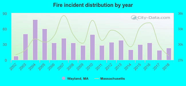 Based on the data from the years 2002 - 2018 the average number of fires per year is 36. The highest number of reported fire incidents - 78 took place in 2004, and the least - 8 in 2002. The data has a rising trend.
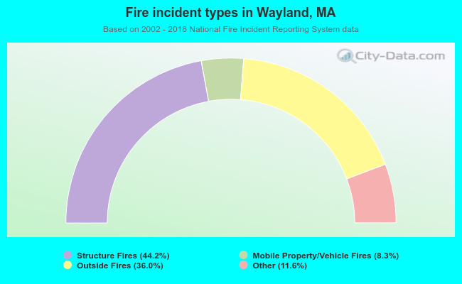 When looking into fire subcategories, the most incidents belonged to: Structure Fires (44.2%), and Outside Fires (36.0%).
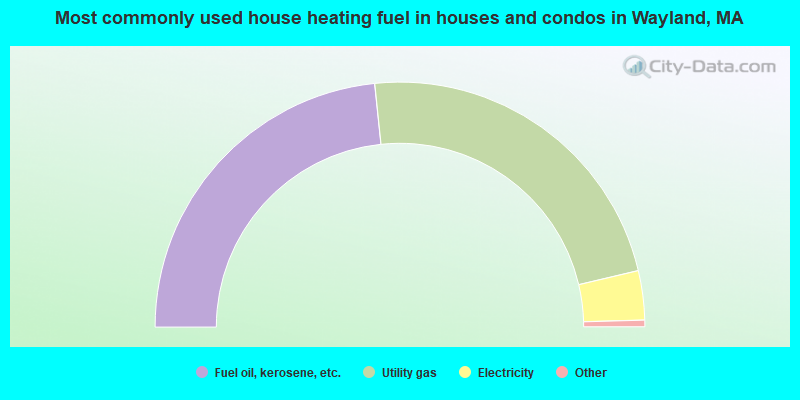
- 46.7%Fuel oil, kerosene, etc.
- 45.9%Utility gas
- 6.5%Electricity
- 0.8%Bottled, tank, or LP gas
- 0.2%Wood
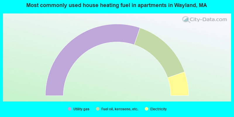
- 60.4%Utility gas
- 28.8%Fuel oil, kerosene, etc.
- 10.8%Electricity
Wayland compared to Massachusetts state average:
- Median household income above state average.
- Median house value above state average.
- Unemployed percentage significantly below state average.
- Black race population percentage significantly below state average.
- Hispanic race population percentage significantly below state average.
- Median age above state average.
- Foreign-born population percentage below state average.
- Renting percentage significantly below state average.
- Length of stay since moving in significantly above state average.
- Number of rooms per house significantly below state average.
- House age significantly below state average.
- Number of college students below state average.
- Percentage of population with a bachelor's degree or higher above state average.
Wayland on our top lists:
- #9 on the list of "Top 101 cities with largest percentage of females in occupations: lawyers (population 5,000+)"
- #16 on the list of "Top 101 cities with largest percentage of females in occupations: art and design workers (population 5,000+)"
- #17 on the list of "Top 101 cities with largest percentage of females in occupations: architects, surveyors, and cartographers (population 5,000+)"
- #22 on the list of "Top 101 cities with largest percentage of males in industries: data processing, libraries, and other information services (population 5,000+)"
- #22 on the list of "Top 101 cities with largest percentage of females in occupations: media and communication equipment workers (population 5,000+)"
- #27 on the list of "Top 101 cities with largest percentage of males in occupations: social scientists and related workers (population 5,000+)"
- #27 on the list of "Top 101 cities with largest percentage of females in industries: data processing, libraries, and other information services (population 5,000+)"
- #30 on the list of "Top 101 cities with the lowest number of thefts per 100,000 residents (population 5,000+)"
- #30 on the list of "Top 101 cities with largest percentage of males in occupations: postsecondary teachers (population 5,000+)"
- #30 on the list of "Top 101 cities with largest percentage of males in industries: health care (population 5,000+)"
- #37 on the list of "Top 101 cities with largest percentage of males in industries: jewelry, luggage, and leather goods stores (population 5,000+)"
- #39 on the list of "Top 100 safest cities (lowest city-data.com crime index) (pop. 5,000+)"
- #53 on the list of "Top 101 cities with largest percentage of males in industries: radio, tv, and computer stores (population 5,000+)"
- #54 on the list of "Top 100 high-educated but low-earning cities (pop. 5,000+)"
- #55 on the list of "Top 101 cities with largest percentage of females in industries: jewelry, luggage, and leather goods stores (population 5,000+)"
- #56 on the list of "Top 101 cities with largest percentage of females in industries: electronic shopping and mail-order houses (population 5,000+)"
- #61 on the list of "Top 101 cities with largest percentage of males in industries: professional and commercial equipment and supplies merchant wholesalers (population 5,000+)"
- #64 on the list of "Top 101 cities with largest percentage of females in industries: publishing, and motion picture and sound recording industries (population 5,000+)"
- #68 on the list of "Top 101 cities with largest percentage of females in industries: leather and allied products (population 5,000+)"
- #80 on the list of "Top 101 cities with the lowest city-data.com crime index (population 5,000+)"
- #96 (01778) on the list of "Top 101 zip codes with the highest 2012 average taxable interest for individuals (pop 5,000+)"
- #4 on the list of "Top 101 counties with the most Orthodox adherents"
- #7 on the list of "Top 101 counties with the most Catholic adherents"
- #7 on the list of "Top 101 counties with the most Mainline Protestant congregations"
- #7 on the list of "Top 101 counties with the most Orthodox congregations"
- #8 on the list of "Top 101 counties with the lowest percentage of residents that keep firearms around their homes"

|
|
Total of 1591 patent applications in 2008-2024.