Lincoln, Massachusetts
Submit your own pictures of this town and show them to the world
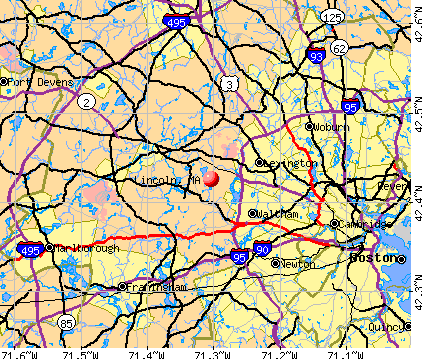
- OSM Map
- General Map
- Google Map
- MSN Map
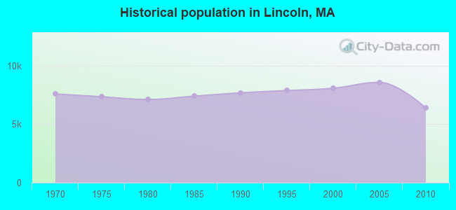
Population change since 2000: -21.0%
| Males: 3,048 | |
| Females: 3,314 |
| Median resident age: | 43.4 years |
| Massachusetts median age: | 39.2 years |
Zip codes: 01773.
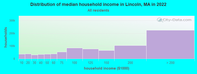
| Lincoln: | $154,314 |
| MA: | $94,488 |
Estimated per capita income in 2022: $101,930 (it was $49,095 in 2000)
Lincoln town income, earnings, and wages data
Estimated median house or condo value in 2022: over $1,000,000 (it was $555,300 in 2000)
| Lincoln: | over $1,000,000 |
| MA: | $534,700 |
Mean prices in 2022: all housing units: $796,617; detached houses: $834,667; townhouses or other attached units: $772,440; in 2-unit structures: $786,250; in 3-to-4-unit structures: $655,835; in 5-or-more-unit structures: $590,321; mobile homes: $144,935
Detailed information about poverty and poor residents in Lincoln, MA
Compare current foreclosures near Lincoln, MA:


- 5,26682.8%White alone
- 3475.5%Asian alone
- 3165.0%Hispanic
- 2243.5%Black alone
- 1722.7%Two or more races
- 210.3%Other race alone
- 100.2%American Indian alone
- 60.09%Native Hawaiian and Other
Pacific Islander alone

Races in Lincoln detailed stats: ancestries, foreign born residents, place of birth
Type |
2009 |
2010 |
2011 |
2012 |
2013 |
2014 |
2015 |
2016 |
2017 |
2018 |
2019 |
2020 |
2021 |
2022 |
|---|---|---|---|---|---|---|---|---|---|---|---|---|---|---|
| Murders (per 100,000) | 0 (0.0) | 0 (0.0) | 0 (0.0) | 0 (0.0) | 1 (15.2) | 0 (0.0) | 0 (0.0) | 0 (0.0) | 0 (0.0) | 0 (0.0) | 0 (0.0) | 0 (0.0) | 0 (0.0) | 0 (0.0) |
| Rapes (per 100,000) | 1 (12.3) | 0 (0.0) | 0 (0.0) | 0 (0.0) | 1 (15.2) | 3 (45.2) | 0 (0.0) | 1 (13.2) | 0 (0.0) | 2 (29.2) | 1 (14.7) | 0 (0.0) | 1 (14.1) | 1 (14.7) |
| Robberies (per 100,000) | 0 (0.0) | 0 (0.0) | 0 (0.0) | 0 (0.0) | 1 (15.2) | 0 (0.0) | 0 (0.0) | 0 (0.0) | 0 (0.0) | 0 (0.0) | 0 (0.0) | 0 (0.0) | 0 (0.0) | 0 (0.0) |
| Assaults (per 100,000) | 3 (37.0) | 7 (110.0) | 8 (125.0) | 8 (123.3) | 3 (45.7) | 3 (45.2) | 4 (54.4) | 1 (13.2) | 2 (29.2) | 3 (43.9) | 3 (44.1) | 2 (28.2) | 0 (0.0) | 0 (0.0) |
| Burglaries (per 100,000) | 8 (98.7) | 11 (172.9) | 16 (250.0) | 17 (262.1) | 8 (121.9) | 7 (105.5) | 6 (81.6) | 6 (79.5) | 5 (72.9) | 1 (14.6) | 2 (29.4) | 0 (0.0) | 1 (14.1) | 3 (44.0) |
| Thefts (per 100,000) | 26 (320.9) | 46 (723.0) | 41 (640.5) | 28 (431.6) | 29 (441.9) | 34 (512.7) | 27 (367.1) | 39 (516.6) | 35 (510.2) | 24 (350.9) | 14 (205.9) | 20 (282.0) | 20 (281.1) | 14 (205.2) |
| Auto thefts (per 100,000) | 3 (37.0) | 0 (0.0) | 0 (0.0) | 0 (0.0) | 0 (0.0) | 0 (0.0) | 0 (0.0) | 0 (0.0) | 0 (0.0) | 0 (0.0) | 0 (0.0) | 0 (0.0) | 3 (42.2) | 0 (0.0) |
| Arson (per 100,000) | 0 (0.0) | 0 (0.0) | 0 (0.0) | 0 (0.0) | 1 (15.2) | 0 (0.0) | 0 (0.0) | 0 (0.0) | 0 (0.0) | 0 (0.0) | 0 (0.0) | 0 (0.0) | 0 (0.0) | 0 (0.0) |
| City-Data.com crime index | 40.0 | 63.0 | 68.1 | 60.3 | 82.6 | 73.1 | 31.3 | 39.5 | 31.3 | 47.2 | 30.9 | 16.9 | 26.8 | 23.0 |
The City-Data.com crime index weighs serious crimes and violent crimes more heavily. Higher means more crime, U.S. average is 246.1. It adjusts for the number of visitors and daily workers commuting into cities.
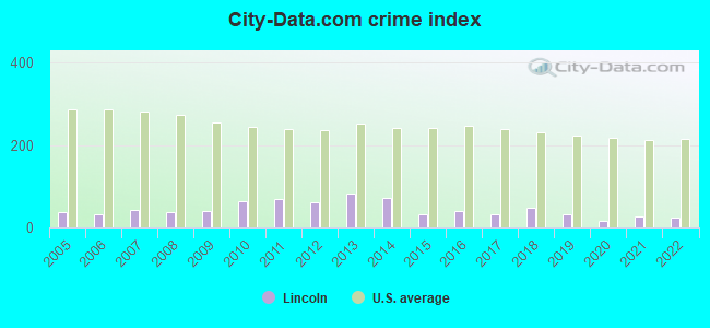
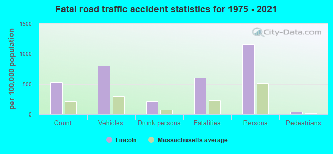
Crime rate in Lincoln detailed stats: murders, rapes, robberies, assaults, burglaries, thefts, arson
Full-time law enforcement employees in 2021, including police officers: 19 (13 officers - 12 male; 1 female).
| Officers per 1,000 residents here: | 1.83 |
| Massachusetts average: | 2.53 |
 Recent articles from our blog. Our writers, many of them Ph.D. graduates or candidates, create easy-to-read articles on a wide variety of topics.

 | Lexington, Concord, Lincoln, Wayland, Sudbury, Weston? (83 replies) |
| 2023 Real Estate Observations (5278 replies) |
| Question about Lincoln (32 replies) |
| Acton or…? (77 replies) |
| Why is BPS so bad and what should be done to improve it? (589 replies) |
| 2021 Real Estate Observations (1729 replies) |
Latest news from Lincoln, MA collected exclusively by city-data.com from local newspapers, TV, and radio stations
Lincoln, MA City Guides:
Ancestries: English (21.2%), Irish (16.8%), German (14.6%), Italian (13.3%), United States (6.8%), Scottish (4.3%).
Current Local Time: EST time zone
Incorporated in 1754
Elevation: 258 feet
Land area: 14.4 square miles.
Population density: 443 people per square mile (low).
552 residents are foreign born (2.8% Asia, 2.8% Europe, 0.7% Latin America).
| This town: | 6.9% |
| Massachusetts: | 12.2% |
| Lincoln town: | 1.1% ($5,890) |
| Massachusetts: | 1.3% ($2,336) |
Nearest city with pop. 50,000+: Waltham, MA  (4.7 miles , pop. 59,226).
Nearest city with pop. 200,000+: Boston, MA (13.1 miles , pop. 589,141).
Nearest city with pop. 1,000,000+: Bronx, NY (172.0 miles , pop. 1,332,650).
Nearest cities:
), ), ), Latitude: 42.43 N, Longitude: 71.30 W
Area codes: 781, 339

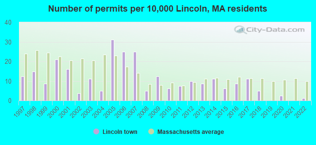
Single-family new house construction building permits:
- 2022: 1 building, cost: $684,000
- 2020: 2 buildings, average cost: $1,279,500
- 2018: 4 buildings, average cost: $616,300
- 2017: 9 buildings, average cost: $1,632,800
- 2016: 7 buildings, average cost: $730,800
- 2015: 5 buildings, average cost: $596,300
- 2014: 9 buildings, average cost: $599,600
- 2013: 7 buildings, average cost: $734,000
- 2012: 8 buildings, average cost: $843,300
- 2011: 6 buildings, average cost: $713,200
- 2010: 5 buildings, average cost: $557,200
- 2009: 10 buildings, average cost: $1,112,200
- 2008: 4 buildings, average cost: $854,200
- 2007: 20 buildings, average cost: $841,300
- 2006: 20 buildings, average cost: $368,700
- 2005: 25 buildings, average cost: $248,100
- 2004: 4 buildings, average cost: $742,300
- 2003: 9 buildings, average cost: $641,800
- 2002: 3 buildings, average cost: $917,000
- 2001: 13 buildings, average cost: $747,400
- 2000: 17 buildings, average cost: $510,500
- 1999: 7 buildings, average cost: $434,900
- 1998: 12 buildings, average cost: $421,900
- 1997: 10 buildings, average cost: $394,400
| Here: | 3.0% |
| Massachusetts: | 3.5% |
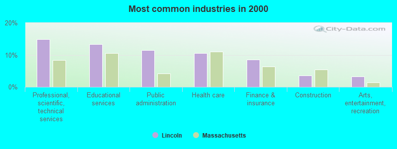
- Professional, scientific, technical services (14.9%)
- Educational services (13.3%)
- Public administration (11.5%)
- Health care (10.6%)
- Finance & insurance (8.5%)
- Construction (3.6%)
- Arts, entertainment, recreation (3.2%)
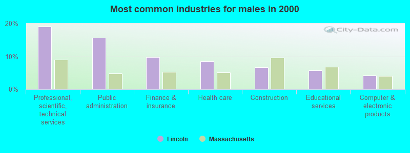
- Professional, scientific, technical services (19.0%)
- Public administration (15.6%)
- Finance & insurance (9.7%)
- Health care (8.5%)
- Construction (6.6%)
- Educational services (5.7%)
- Computer & electronic products (4.2%)
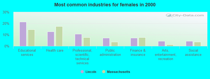
- Educational services (21.3%)
- Health care (12.8%)
- Professional, scientific, technical services (10.6%)
- Public administration (7.2%)
- Finance & insurance (7.2%)
- Arts, entertainment, recreation (4.4%)
- Social assistance (4.4%)
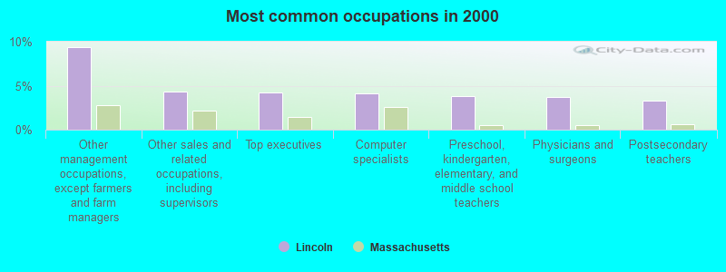
- Other management occupations, except farmers and farm managers (9.4%)
- Other sales and related occupations, including supervisors (4.4%)
- Top executives (4.2%)
- Computer specialists (4.1%)
- Preschool, kindergarten, elementary, and middle school teachers (3.8%)
- Physicians and surgeons (3.7%)
- Postsecondary teachers (3.3%)
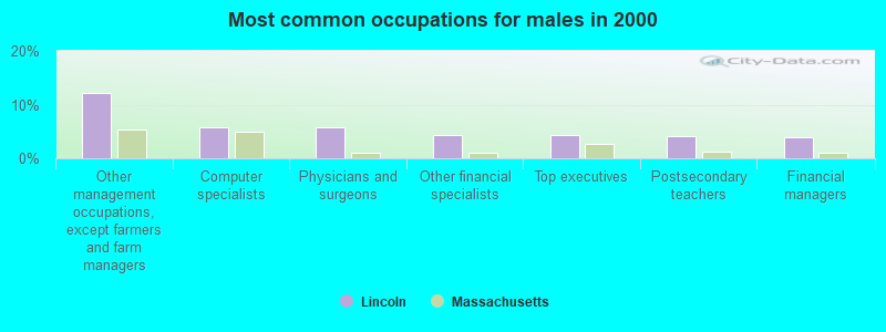
- Other management occupations, except farmers and farm managers (12.1%)
- Computer specialists (5.8%)
- Physicians and surgeons (5.8%)
- Other financial specialists (4.3%)
- Top executives (4.3%)
- Postsecondary teachers (4.2%)
- Financial managers (3.9%)
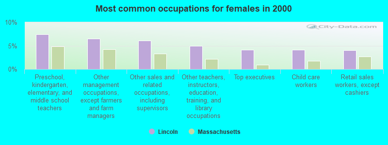
- Preschool, kindergarten, elementary, and middle school teachers (7.4%)
- Other management occupations, except farmers and farm managers (6.5%)
- Other sales and related occupations, including supervisors (6.1%)
- Other teachers, instructors, education, training, and library occupations (5.0%)
- Top executives (4.1%)
- Child care workers (4.1%)
- Retail sales workers, except cashiers (4.0%)
Average climate in Lincoln, Massachusetts
Based on data reported by over 4,000 weather stations


(lower is better)
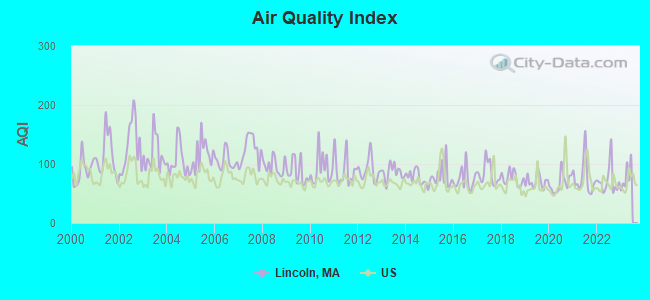
Air Quality Index (AQI) level in 2022 was 71.9. This is about average.
| City: | 71.9 |
| U.S.: | 72.6 |
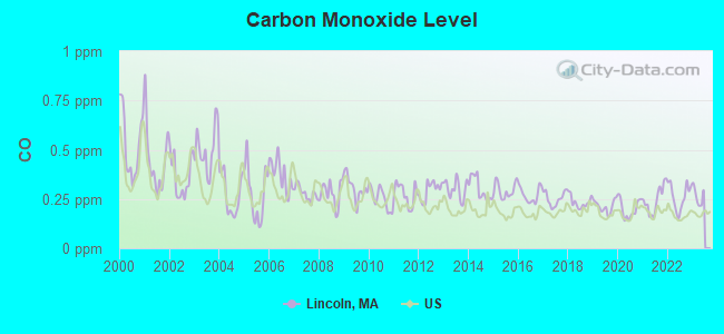
Carbon Monoxide (CO) [ppm] level in 2022 was 0.263. This is about average. Closest monitor was 5.0 miles away from the city center.
| City: | 0.263 |
| U.S.: | 0.251 |
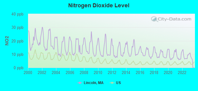
Nitrogen Dioxide (NO2) [ppb] level in 2022 was 8.80. This is significantly worse than average. Closest monitor was 5.0 miles away from the city center.
| City: | 8.80 |
| U.S.: | 5.11 |
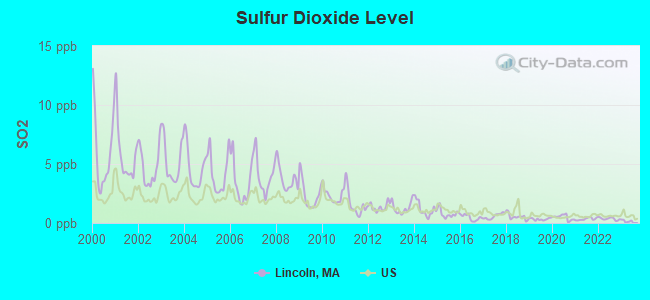
Sulfur Dioxide (SO2) [ppb] level in 2022 was 0.358. This is significantly better than average. Closest monitor was 5.0 miles away from the city center.
| City: | 0.358 |
| U.S.: | 1.515 |
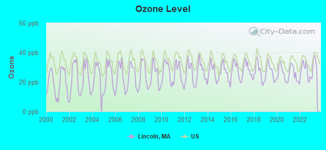
Ozone [ppb] level in 2022 was 27.7. This is better than average. Closest monitor was 4.3 miles away from the city center.
| City: | 27.7 |
| U.S.: | 33.3 |
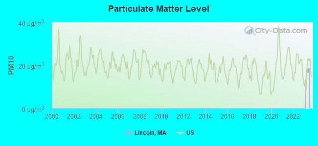
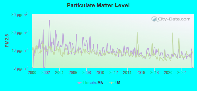
Particulate Matter (PM2.5) [µg/m3] level in 2022 was 6.68. This is better than average. Closest monitor was 9.2 miles away from the city center.
| City: | 6.68 |
| U.S.: | 8.11 |
Tornado activity:
Lincoln-area historical tornado activity is near Massachusetts state average. It is 35% smaller than the overall U.S. average.
On 6/9/1953, a category F4 (max. wind speeds 207-260 mph) tornado 14.1 miles away from the Lincoln town center killed 90 people and injured 1228 people and caused between $50,000,000 and $500,000,000 in damages.
On 9/29/1974, a category F3 (max. wind speeds 158-206 mph) tornado 12.6 miles away from the town center injured one person and caused between $50,000 and $500,000 in damages.
Earthquake activity:
Lincoln-area historical earthquake activity is significantly above Massachusetts state average. It is 73% smaller than the overall U.S. average.On 10/7/1983 at 10:18:46, a magnitude 5.3 (5.1 MB, 5.3 LG, 5.1 ML, Class: Moderate, Intensity: VI - VII) earthquake occurred 186.1 miles away from Lincoln center
On 4/20/2002 at 10:50:47, a magnitude 5.3 (5.3 ML, Depth: 3.0 mi) earthquake occurred 187.8 miles away from Lincoln center
On 1/19/1982 at 00:14:42, a magnitude 4.7 (4.5 MB, 4.7 MD, 4.5 LG, Class: Light, Intensity: IV - V) earthquake occurred 75.8 miles away from the city center
On 4/20/2002 at 10:50:47, a magnitude 5.2 (5.2 MB, 4.2 MS, 5.2 MW, 5.0 MW) earthquake occurred 187.1 miles away from Lincoln center
On 10/16/2012 at 23:12:25, a magnitude 4.7 (4.7 ML, Depth: 10.0 mi) earthquake occurred 87.4 miles away from the city center
On 8/22/1992 at 12:20:32, a magnitude 4.8 (4.8 MB, 3.8 MS, 4.7 LG, Depth: 6.2 mi) earthquake occurred 235.3 miles away from the city center
Magnitude types: regional Lg-wave magnitude (LG), body-wave magnitude (MB), duration magnitude (MD), local magnitude (ML), surface-wave magnitude (MS), moment magnitude (MW)
Natural disasters:
The number of natural disasters in Middlesex County (31) is a lot greater than the US average (15).Major Disasters (Presidential) Declared: 17
Emergencies Declared: 14
Causes of natural disasters: Floods: 12, Storms: 9, Hurricanes: 6, Snowstorms: 6, Winter Storms: 5, Blizzards: 2, Snows: 2, Explosion: 1, Heavy Rain: 1, Snowfall: 1, Water Main Break: 1, Wind: 1 (Note: some incidents may be assigned to more than one category).

Hospitals and medical centers near Lincoln:
- RESERVOIR CENTER (Nursing Home, about 2 miles away; WALTHAM, MA)
- RESERVOIR NURSING HOME (Nursing Home, about 2 miles away; WALTHAM, MA)
- AT HOME VNA (Home Health Center, about 2 miles away; WALTHAM, MA)
- EVERCARE HOSPICE AND PALLIATIVE CARE (Hospital, about 3 miles away; WALTHAM, MA)
- NEW ENGLAND HOME HEALTH SERVIC (Home Health Center, about 3 miles away; LEXINGTON, MA)
- AMEDISYS HOME HEALTH OF WALTHAM (Home Health Center, about 4 miles away; WALTHAM, MA)
- PARTNERS HEALTHCARE AT HOME - HOME CARE (Home Health Center, about 4 miles away; WALTHAM, MA)
Heliports located in Lincoln:
Amtrak stations near Lincoln:
- 11 miles: WOBURN (100 ATLANTIC AVE.) . Services: ticket office.
- 12 miles: FRAMINGHAM (443 WAVERLY ST.) . Services: public payphones, snack bar, paid short-term parking, taxi stand, public transit connection.
- 13 miles: BACK BAY (BOSTON, 145 DARTMOUTH ST.) . Services: ticket office, partially wheelchair accessible, enclosed waiting area, public restrooms, public payphones, vending machines, ATM, paid short-term parking, paid long-term parking, call for car rental service, taxi stand, public transit connection.
Colleges/universities with over 2000 students nearest to Lincoln:
- Brandeis University (about 5 miles; Waltham, MA; Full-time enrollment: 6,966)
- Bentley University (about 5 miles; Waltham, MA; FT enrollment: 5,229)
- Middlesex Community College (about 8 miles; Bedford, MA; FT enrollment: 6,040)
- Massachusetts Bay Community College (about 9 miles; Wellesley Hills, MA; FT enrollment: 3,636)
- Boston College (about 10 miles; Chestnut Hill, MA; FT enrollment: 12,070)
- Babson College (about 10 miles; Wellesley, MA; FT enrollment: 3,230)
- Wellesley College (about 10 miles; Wellesley, MA; FT enrollment: 2,658)
Private high school in Lincoln:
Public elementary/middle school in Lincoln:
- LINCOLN SCHOOL (Students: 660, Location: 6 BALLFIELD ROAD, Grades: PK-8)
Library in Lincoln:
Points of interest:
Notable locations in Lincoln: Josiah Nelson House Site (A), Lincoln Station (B), Samuel Hartwell Farm Site (C), Tabitha Nelson Farm Site (D), Paul Revere Capture Site (E), Bloody Angles (F), Hartwell (G), Town of Lincoln Ambulance Service (H), DeCordova and Dana Museum (I), William Smith House (J), Lincoln Fire Department (K), Hanscom Primary Library (L), Codman House (M), Gropius House (N), Codman House Museum (O), Decordova Museum and Sculpture Park (P), Decordova Museum and Sculpture Park Library (Q), Hatheway Environmental Resource Library (R), Lincoln Public Library (S), Lincoln Town Hall (T). Display/hide their locations on the map
Churches in Lincoln include: First Parish in Lincoln Church (A), Saint Annes Church (B). Display/hide their locations on the map
Cemetery: Lincoln Cemetery (1). Display/hide its location on the map
Lakes and reservoirs: Beaver Pond (A), Mill Pond (B), Warner Pond (C), Todd Pond (D), Folly Pond (E), Farrar Pond (F), Lincoln Reservoir (G), Flints Pond (H). Display/hide their locations on the map
Streams, rivers, and creeks: Iron Mine Brook (A). Display/hide its location on the map
Parks in Lincoln include: Lincoln Center Historic District (1), Pierce Park (2), Drumlin Farm Bird Sanctuary (3), Farrington Memorial (4), Minute Man National Historical Park (5). Display/hide their locations on the map
Tourist attractions: Decordova Museum & Sculpture Park (51 Sandy Pond Road) (1), Decordova Museum & Sculpture Park - Museum School (51 Sandy Pond Road) (2). Display/hide their approximate locations on the map
Hotel: Minute Man Inn The (82 Virginia Road) (1). Display/hide its approximate location on the map
Birthplace of: John Farrar (scientist) - Scholar, John Flansburgh - Male singer, John Linnell - Accordionist.
Drinking water stations with addresses in Lincoln and their reported violations in the past:
LINCOLN WATER DEPT (Population served: 5,112, Surface water):Past health violations:WILDWOOD/WELL SPOT (Address: 208 SOUTH GREAT RD , Serves NH, Population served: 110, Groundwater):Past monitoring violations:
- MCL, Monthly (TCR) - In SEP-2013, Contaminant: Coliform. Follow-up actions: St AO (w/o penalty) issued (OCT-10-2013)
- MCL, Monthly (TCR) - In AUG-2013, Contaminant: Coliform. Follow-up actions: St AO (w/o penalty) issued (SEP-16-2013)
- MCL, Average - Between APR-2006 and JUN-2006, Contaminant: TTHM. Follow-up actions: St AO (w/o penalty) issued (JUN-27-2006)
- Follow-up Or Routine LCR Tap M/R - In OCT-01-2006, Contaminant: Lead and Copper Rule. Follow-up actions: St AO (w/o penalty) issued (DEC-07-2006), St Compliance achieved (JUN-19-2007)
- Follow-up Or Routine LCR Tap M/R - In OCT-01-2005, Contaminant: Lead and Copper Rule. Follow-up actions: St AO (w/o penalty) issued (JAN-19-2006), St Compliance achieved (NOV-27-2007)
- 2 minor monitoring violations
- 51 regular monitoring violations
Past monitoring violations:
- Monitoring, Source Water (GWR) - Between OCT-01-2011 and NOV-01-2011, Contaminant: E. COLI. Follow-up actions: St Public Notif requested (NOV-01-2011), St Violation/Reminder Notice (NOV-01-2011), St Compliance achieved (NOV-02-2011), St Public Notif received (NOV-18-2011)
- Monitoring, Repeat Major (TCR) - Between JUL-2011 and SEP-2011, Contaminant: Coliform (TCR). Follow-up actions: St Public Notif requested (NOV-01-2011), St Violation/Reminder Notice (NOV-01-2011), St Compliance achieved (NOV-02-2011), St Public Notif received (NOV-18-2011)
| This town: | 2.6 people |
| Massachusetts: | 2.5 people |
| This town: | 75.1% |
| Whole state: | 63.0% |
| This town: | 3.2% |
| Whole state: | 7.0% |
Likely homosexual households (counted as self-reported same-sex unmarried-partner households)
- Lesbian couples: 0.5% of all households
- Gay men: 0.2% of all households
| This town: | 0.8% |
| Whole state: | 9.3% |
| This town: | 0.5% |
| Whole state: | 4.4% |
People in group quarters in Lincoln in 2000:
- 138 people in military barracks, etc.
- 10 people in homes for the mentally ill
- 4 people in homes for the mentally retarded
Banks with branches in Lincoln (2011 data):
- Cambridge Trust Company: Lincoln Branch at 152 Lincoln Road, branch established on 2001/11/26. Info updated 2006/09/29: Bank assets: $1,275.9 mil, Deposits: $1,129.9 mil, headquarters in Cambridge, MA, positive income, Mortgage Lending Specialization, 13 total offices, Holding Company: Cambridge Bancorp
- Bank of America, National Association: Lincoln Branch at 145 Lincoln Road, branch established on 2000/06/17. Info updated 2009/11/18: Bank assets: $1,451,969.3 mil, Deposits: $1,077,176.8 mil, headquarters in Charlotte, NC, positive income, 5782 total offices, Holding Company: Bank Of America Corporation
For population 15 years and over in Lincoln:
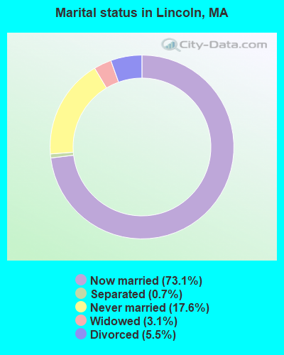
- Never married: 17.6%
- Now married: 73.1%
- Separated: 0.7%
- Widowed: 3.1%
- Divorced: 5.5%
For population 25 years and over in Lincoln:
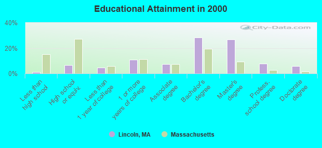
- High school or higher: 98.7%
- Bachelor's degree or higher: 69.2%
- Graduate or professional degree: 40.7%
- Unemployed: 1.9%
- Mean travel time to work (commute): 25.5 minutes
| Here: | 8.9 |
| Massachusetts average: | 13.1 |


Graphs represent county-level data. Detailed 2008 Election Results
Religion statistics for Lincoln, MA (based on Middlesex County data)


| Religion | Adherents | Congregations |
|---|---|---|
| Catholic | 718,209 | 107 |
| Mainline Protestant | 70,053 | 269 |
| Other | 68,480 | 199 |
| Evangelical Protestant | 41,270 | 304 |
| Orthodox | 23,641 | 28 |
| Black Protestant | 2,276 | 8 |
| None | 579,156 | - |
Food Environment Statistics:
| Middlesex County: | 1.71 / 10,000 pop. |
| Massachusetts: | 1.98 / 10,000 pop. |
| This county: | 0.03 / 10,000 pop. |
| Massachusetts: | 0.05 / 10,000 pop. |
| Middlesex County: | 2.14 / 10,000 pop. |
| Massachusetts: | 2.22 / 10,000 pop. |
| Middlesex County: | 1.38 / 10,000 pop. |
| State: | 1.77 / 10,000 pop. |
| This county: | 7.84 / 10,000 pop. |
| Massachusetts: | 8.76 / 10,000 pop. |
| Here: | 7.8% |
| Massachusetts: | 8.1% |
| Middlesex County: | 21.5% |
| Massachusetts: | 22.5% |
| This county: | 18.0% |
| State: | 16.5% |
6.91% of this county's 2021 resident taxpayers lived in other counties in 2020 ($102,955 average adjusted gross income)
| Here: | 6.91% |
| Massachusetts average: | 6.35% |
0.01% of residents moved from foreign countries ($137 average AGI)
Middlesex County: 0.01% Massachusetts average: 0.01%
Top counties from which taxpayers relocated into this county between 2020 and 2021:
| from Suffolk County, MA | |
| from Essex County, MA | |
| from Norfolk County, MA |
8.22% of this county's 2020 resident taxpayers moved to other counties in 2021 ($123,369 average adjusted gross income)
| Here: | 8.22% |
| Massachusetts average: | 7.18% |
0.01% of residents moved to foreign countries ($124 average AGI)
Middlesex County: 0.01% Massachusetts average: 0.02%
Top counties to which taxpayers relocated from this county between 2020 and 2021:
| to Suffolk County, MA | |
| to Essex County, MA | |
| to Worcester County, MA |
Businesses in Lincoln, MA
- FedEx: 2
- UPS: 2
Strongest AM radio stations in Lincoln:
- WRKO (680 AM; 50 kW; BOSTON, MA; Owner: ENTERCOM BOSTON LICENSE, LLC)
- WWZN (1510 AM; 50 kW; BOSTON, MA; Owner: ROSE CITY RADIO CORPORATION)
- WRCA (1330 AM; 25 kW; WALTHAM, MA; Owner: WRCA LICENSE, LLC)
- WEEI (850 AM; 50 kW; BOSTON, MA; Owner: ENTERCOM BOSTON LICENSE, LLC)
- WKOX (1200 AM; 50 kW; FRAMINGHAM, MA; Owner: CAPSTAR TX LIMITED PARTNERSHIP)
- WBIX (1060 AM; 40 kW; NATICK, MA; Owner: LANGER BROADCASTING CORPORATION)
- WNTN (1550 AM; 10 kW; NEWTON, MA; Owner: COLT COMMUNICATIONS, LLC)
- WBPS (1150 AM; 5 kW; BOSTON, MA; Owner: MEGA COMMUNICATIONS OF BOSTON LICENSEE, L.L.C.)
- WAMG (890 AM; 25 kW; DEDHAM, MA; Owner: MEGA COMMUNICATIONS OF DEDHAM LICENSEE, LLC)
- WBNW (1120 AM; 5 kW; CONCORD, MA; Owner: MONEY MATTERS RADIO, INC.)
- WUNR (1600 AM; 20 kW; BROOKLINE, MA; Owner: CHAMPION BROADCASTING SYSTEMS, INC.)
- WBZ (1030 AM; 50 kW; BOSTON, MA; Owner: INFINITY BROADCASTING OPERATIONS, INC.)
- WEZE (590 AM; 5 kW; BOSTON, MA; Owner: NEW ENGLAND CONTINENTAL MEDIA, INC.)
Strongest FM radio stations in Lincoln:
- WBMX (98.5 FM; BOSTON, MA; Owner: INFINITY RADIO OPERATIONS INC.)
- WJMN (94.5 FM; BOSTON, MA; Owner: AMFM RADIO LICENSES, L.L.C.)
- WCRB (102.5 FM; WALTHAM, MA; Owner: CHARLES RIVER BROADCASTING WCRB LICE)
- WTKK (96.9 FM; BOSTON, MA; Owner: GREATER BOSTON RADIO, INC.)
- WROR-FM (105.7 FM; FRAMINGHAM, MA; Owner: GREATER BOSTON RADIO, INC.)
- WGBH (89.7 FM; BOSTON, MA; Owner: WGBH EDUCATIONAL FOUNDATION)
- WBOS (92.9 FM; BROOKLINE, MA; Owner: GREATER BOSTON RADIO, INC.)
- WBUR-FM (90.9 FM; BOSTON, MA; Owner: TRUSTEES OF BOSTON UNIVERSITY)
- WODS (103.3 FM; BOSTON, MA; Owner: INFINITY BROADCASTING OPERATIONS, INC.)
- WXKS-FM (107.9 FM; MEDFORD, MA; Owner: AMFM RADIO LICENSES, L.L.C.)
- WMJX (106.7 FM; BOSTON, MA; Owner: GREATER BOSTON RADIO, INC.)
- WBCN (104.1 FM; BOSTON, MA; Owner: HEMISPHERE BROADCASTING CORPORATION)
- WZLX (100.7 FM; BOSTON, MA; Owner: INFINITY BROADCASTING CORPORATION OF BOSTON)
- W267AI (101.3 FM; BOSTON, MA; Owner: MCC BROADCASTING COMPANY, INC.)
- WERS (88.9 FM; BOSTON, MA; Owner: EMERSON COLLEGE)
- WBRS (100.1 FM; WALTHAM, MA; Owner: BRANDEIS UNIVERSITY)
- WHRB (95.3 FM; CAMBRIDGE, MA; Owner: HARVARD RADIO BROADCASTING CO., INC.)
- WYAJ (97.7 FM; SUDBURY, MA; Owner: SUDBURY VALLEY B'CASTING FOUNDATION)
- WFNX (101.7 FM; LYNN, MA; Owner: MCC BROADCASTING COMPANY, INC.)
- WKLB-FM (99.5 FM; LOWELL, MA; Owner: GREATER BOSTON RADIO, INC.)
TV broadcast stations around Lincoln:
- WCVB-TV (Channel 5; BOSTON, MA; Owner: WCVB HEARST-ARGYLE TV, INC.)
- WGBH-TV (Channel 2; BOSTON, MA; Owner: WGBH EDUCATIONAL FOUNDATION)
- WBZ-TV (Channel 4; BOSTON, MA; Owner: VIACOM INC.)
- WGBX-TV (Channel 44; BOSTON, MA; Owner: WGBH EDUCATIONAL FOUNDATION)
- WHDH-TV (Channel 7; BOSTON, MA; Owner: WHDH-TV)
- WMFP (Channel 62; LAWRENCE, MA; Owner: WSAH LICENSE, INC.)
- WSBK-TV (Channel 38; BOSTON, MA; Owner: VIACOM INC.)
- WLVI-TV (Channel 56; CAMBRIDGE, MA; Owner: WLVI, INC.)
- WFXT (Channel 25; BOSTON, MA; Owner: FOX TELEVISION STATIONS INC.)
- WUTF (Channel 66; MARLBOROUGH, MA; Owner: TELEFUTURA BOSTON LLC)
- W40BO (Channel 40; BOSTON, MA; Owner: PAXSON COMMUNICATIONS LPTV, INC.)
- WBPX (Channel 68; BOSTON, MA; Owner: PAXSON BOSTON-68 LICENSE, INC.)
- WTMU-LP (Channel 32; BOSTON, MA; Owner: ZGS BOSTON, INC.)
- WCEA-LP (Channel 58; BOSTON, MA; Owner: CHANNEL 19 TV CORPORATION)
- WUNI (Channel 27; WORCESTER, MA; Owner: ENTRAVISION HOLDINGS, LLC)
- WFXZ-CA (Channel 24; BOSTON, MA; Owner: BOSTON BROADCASTING CORP.)
- WWDP (Channel 46; NORWELL, MA; Owner: NORWELL TELEVISION, LLC)
- WNDS (Channel 50; DERRY, NH; Owner: CTV OF DERRY, INC)
- WNAC-TV (Channel 64; PROVIDENCE, RI; Owner: WNAC, LLC)
- WPRI-TV (Channel 12; PROVIDENCE, RI; Owner: TVL BROADCASTING OF RHODE ISLAND, LLC)
- WLNE-TV (Channel 6; NEW BEDFORD, MA; Owner: FREEDOM BROADCASTING OF SOUTHERN NEW ENGLAND, INC.)
- WJAR (Channel 10; PROVIDENCE, RI; Owner: OUTLET BROADCASTING, INC.)
- WHDN-LP (Channel 26; BOSTON, MA; Owner: GUENTER MARKSTEINER)
- WSBE-TV (Channel 36; PROVIDENCE, RI; Owner: RHODE ISLAND PUBLIC TELECOM. AUTHORITY)
- National Bridge Inventory (NBI) Statistics
- 1Number of bridges
- 16ft / 5.5mTotal length
- $3,923,000Total costs
- 6,853Total average daily traffic
- 753Total average daily truck traffic
- 8,370Total future (year 2032) average daily traffic
FCC Registered Broadcast Land Mobile Towers: 10 (See the full list of FCC Registered Broadcast Land Mobile Towers in Lincoln, MA)
FCC Registered Amateur Radio Licenses: 72 (See the full list of FCC Registered Amateur Radio Licenses in Lincoln)
FAA Registered Aircraft Manufacturers and Dealers: 1 (See the full list of FAA Registered Manufacturers and Dealers in Lincoln)
FAA Registered Aircraft: 18 (See the full list of FAA Registered Aircraft)
2002 - 2018 National Fire Incident Reporting System (NFIRS) incidents
- Fire incident types reported to NFIRS in Lincoln, MA
- 63269.7%Structure Fires
- 12814.1%Other
- 10912.0%Outside Fires
- 384.2%Mobile Property/Vehicle Fires
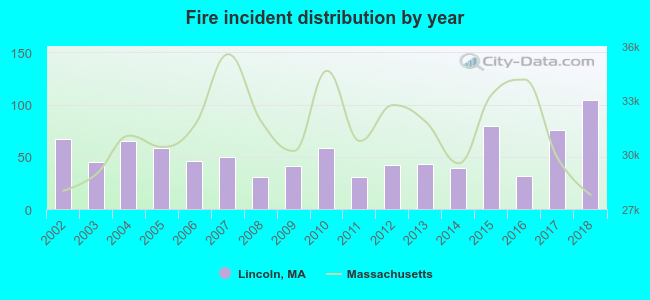 Based on the data from the years 2002 - 2018 the average number of fire incidents per year is 53. The highest number of fire incidents - 104 took place in 2018, and the least - 31 in 2008. The data has an increasing trend.
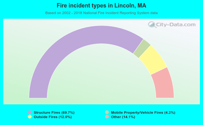 When looking into fire subcategories, the most reports belonged to: Structure Fires (69.7%), and Other (14.1%).
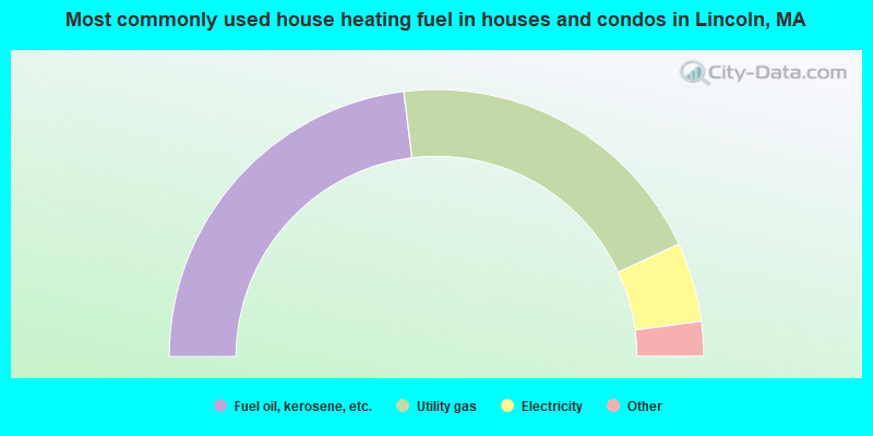
- 46.1%Fuel oil, kerosene, etc.
- 40.1%Utility gas
- 9.6%Electricity
- 3.2%Bottled, tank, or LP gas
- 0.6%Wood
- 0.3%Other fuel
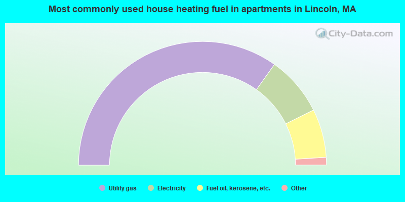
- 69.8%Utility gas
- 15.6%Electricity
- 12.7%Fuel oil, kerosene, etc.
- 1.5%Other fuel
- 0.5%No fuel used
Lincoln compared to Massachusetts state average:
- Median household income above state average.
- Median house value above state average.
- Unemployed percentage significantly below state average.
- Black race population percentage below state average.
- Hispanic race population percentage significantly below state average.
- Median age above state average.
- Foreign-born population percentage significantly below state average.
- Length of stay since moving in significantly above state average.
- Number of rooms per house significantly below state average.
- House age significantly below state average.
- Percentage of population with a bachelor's degree or higher above state average.
Lincoln on our top lists:
- #1 on the list of "Top 101 cities with largest percentage of males in occupations: social scientists and related workers (population 5,000+)"
- #6 on the list of "Top 101 cities with largest percentage of females in occupations: top executives (population 5,000+)"
- #6 on the list of "Top 101 cities with largest percentage of males in occupations: financial managers (population 5,000+)"
- #11 on the list of "Top 101 cities with largest percentage of females in occupations: architects, surveyors, and cartographers (population 5,000+)"
- #11 on the list of "Top 101 cities with largest percentage of males in occupations: physicians and surgeons (population 5,000+)"
- #13 on the list of "Top 101 cities with largest percentage of females in occupations: social scientists and related workers (population 5,000+)"
- #27 on the list of "Top 101 cities with largest percentage of females in industries: retail florists (population 5,000+)"
- #28 on the list of "Top 101 cities with largest percentage of females in industries: clothing and accessories, including shoe, stores (population 5,000+)"
- #35 on the list of "Top 101 cities with the largest percentage population decrease from 2000 (population 5,000+)"
- #42 on the list of "Top 101 cities with the lowest number of auto thefts per 100,000 residents (population 5,000+)"
- #46 on the list of "Top 101 cities with largest percentage of males in industries: health care (population 5,000+)"
- #51 on the list of "Top 101 cities with largest percentage of males in industries: publishing, and motion picture and sound recording industries (population 5,000+)"
- #53 on the list of "Top 100 cities with declining populations from 2000 to 2014 (pop. 5,000+)"
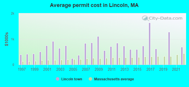
- #55 on the list of "Top 101 cities with the highest cost per building permit(population 5,000+)"
- #63 on the list of "Top 101 cities with largest percentage of males in industries: furniture and home furnishing merchant wholesalers (population 5,000+)"
- #65 on the list of "Top 101 cities with largest percentage of females in industries: book stores and news dealers (population 5,000+)"
- #72 on the list of "Top 101 cities with largest percentage of males in industries: clothing and accessories, including shoe, stores (population 5,000+)"
- #72 on the list of "Top 101 cities with the most people having Master's or Doctorate degrees (population 5,000+)"
- #74 on the list of "Top 101 cities with largest percentage of males in industries: electronic shopping and mail-order houses (population 5,000+)"
- #76 on the list of "Top 100 cities with highest median house value (pop. 5,000+)"
- #27 (01773) on the list of "Top 101 zip codes with the largest percentage of taxpayers reporting net capital gain/loss in 2012 (pop 5,000+)"
- #51 (01773) on the list of "Top 101 zip codes with the largest percentage of taxpayers reporting taxable interest in 2012 (pop 5,000+)"
- #65 (01773) on the list of "Top 101 zip codes with the highest 2012 average Adjusted Gross Income (AGI) for individuals (pop 5,000+)"
- #83 (01773) on the list of "Top 101 zip codes with the highest 2012 average net capital gain/loss (pop 5,000+)"
- #88 (01773) on the list of "Top 101 zip codes with the largest percentage of taxpayers using charity contributions deductions in 2012 (pop 5,000+)"
- #98 (01773) on the list of "Top 101 zip codes with the largest percentage of taxpayers reporting profit/loss from business in 2012 (pop 5,000+)"
- #4 on the list of "Top 101 counties with the most Orthodox adherents"
- #7 on the list of "Top 101 counties with the most Catholic adherents"
- #7 on the list of "Top 101 counties with the most Mainline Protestant congregations"
- #7 on the list of "Top 101 counties with the most Orthodox congregations"
- #8 on the list of "Top 101 counties with the lowest percentage of residents that keep firearms around their homes"

|
|
Total of 1015 patent applications in 2008-2024.