Middleborough, Massachusetts
Submit your own pictures of this town and show them to the world
- OSM Map
- Google Map
- MSN Map
Population change since 2000: +15.9%
 |
| Males: 11,292 | |
| Females: 11,824 |
| Median resident age: | 41.2 years |
| Massachusetts median age: | 39.2 years |
Zip codes: 02346.
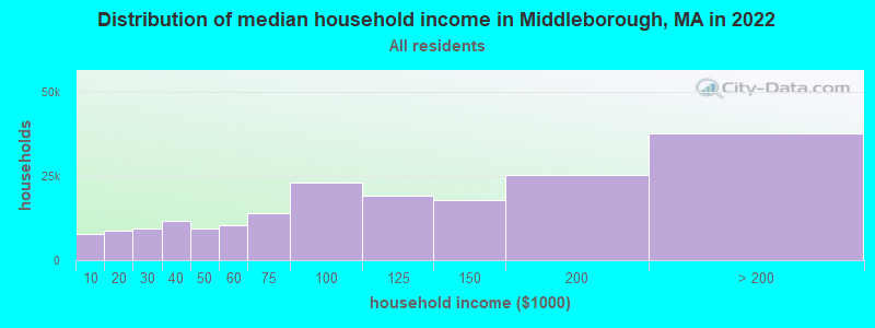
| Middleborough: | $97,867 |
| MA: | $94,488 |
Estimated per capita income in 2022: $44,237 (it was $20,246 in 2000)
Middleborough town income, earnings, and wages data
Estimated median house or condo value in 2022: $494,541 (it was $158,800 in 2000)
| Middleborough: | $494,541 |
| MA: | $534,700 |
Mean prices in 2022: all housing units: $585,203; detached houses: $620,100; townhouses or other attached units: $487,972; in 2-unit structures: $464,355; in 3-to-4-unit structures: $429,583; in 5-or-more-unit structures: $438,441; mobile homes: $207,706; occupied boats, rvs, vans, etc.: $17,153
Detailed information about poverty and poor residents in Middleborough, MA


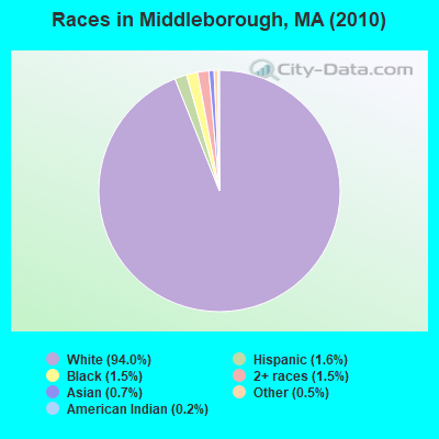
- 21,73094.0%White alone
- 3671.6%Hispanic
- 3421.5%Black alone
- 3401.5%Two or more races
- 1680.7%Asian alone
- 1190.5%Other race alone
- 480.2%American Indian alone
- 20.01%Native Hawaiian and Other
Pacific Islander alone
Races in Middleborough detailed stats: ancestries, foreign born residents, place of birth
According to our research of Massachusetts and other state lists, there were 7 registered sex offenders living in Middleborough, Massachusetts as of May 07, 2024.
The ratio of all residents to sex offenders in Middleborough is 3,302 to 1.
The ratio of registered sex offenders to all residents in this city is lower than the state average.
 Recent articles from our blog. Our writers, many of them Ph.D. graduates or candidates, create easy-to-read articles on a wide variety of topics.
Ancestries: Irish (27.3%), English (20.2%), French (12.3%), Italian (11.5%), Portuguese (8.2%), German (5.7%).
Current Local Time: EST time zone
Incorporated in 1669
Land area: 69.6 square miles.
Population density: 332 people per square mile (very low).
672 residents are foreign born (1.5% Europe, 0.7% Asia, 0.6% Latin America, 0.4% North America).
| This town: | 3.4% |
| Massachusetts: | 12.2% |
| Middleborough town: | 1.4% ($2,298) |
| Massachusetts: | 1.3% ($2,336) |
Nearest city with pop. 50,000+: Taunton, MA  (10.3 miles , pop. 55,976).
Nearest city with pop. 200,000+: Boston, MA (31.5 miles , pop. 589,141).
Nearest city with pop. 1,000,000+: Bronx, NY (170.6 miles , pop. 1,332,650).
Nearest cities:
), ), ), Latitude: 41.89 N, Longitude: 70.89 W
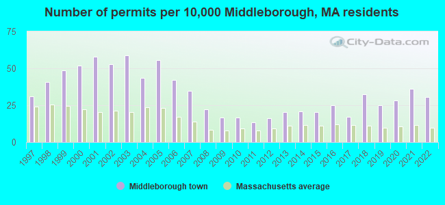
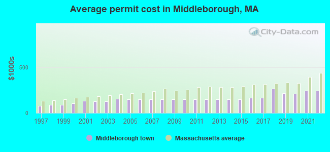
Single-family new house construction building permits:
- 2022: 61 buildings, average cost: $242,100
- 2021: 72 buildings, average cost: $243,600
- 2020: 56 buildings, average cost: $207,900
- 2019: 50 buildings, average cost: $216,000
- 2018: 65 buildings, average cost: $266,000
- 2017: 34 buildings, average cost: $164,300
- 2016: 50 buildings, average cost: $163,500
- 2015: 41 buildings, average cost: $151,500
- 2014: 42 buildings, average cost: $151,500
- 2013: 41 buildings, average cost: $151,500
- 2012: 32 buildings, average cost: $151,500
- 2011: 27 buildings, average cost: $151,500
- 2010: 33 buildings, average cost: $151,500
- 2009: 33 buildings, average cost: $151,500
- 2008: 44 buildings, average cost: $151,500
- 2007: 69 buildings, average cost: $151,500
- 2006: 84 buildings, average cost: $151,700
- 2005: 111 buildings, average cost: $150,600
- 2004: 87 buildings, average cost: $155,900
- 2003: 117 buildings, average cost: $126,800
- 2002: 105 buildings, average cost: $128,700
- 2001: 115 buildings, average cost: $131,100
- 2000: 103 buildings, average cost: $107,400
- 1999: 97 buildings, average cost: $91,200
- 1998: 81 buildings, average cost: $90,000
- 1997: 62 buildings, average cost: $76,100
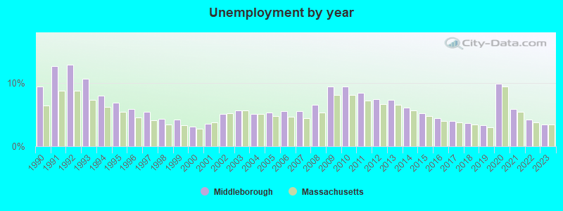
| Here: | 3.5% |
| Massachusetts: | 3.5% |
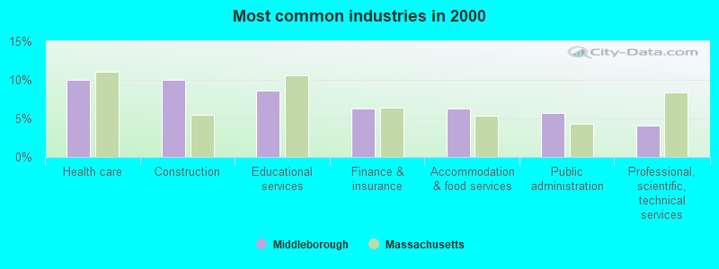
- Health care (10.1%)
- Construction (10.0%)
- Educational services (8.6%)
- Finance & insurance (6.3%)
- Accommodation & food services (6.3%)
- Public administration (5.7%)
- Professional, scientific, technical services (4.1%)
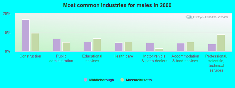
- Construction (16.9%)
- Public administration (6.7%)
- Educational services (5.1%)
- Health care (4.6%)
- Motor vehicle & parts dealers (4.5%)
- Accommodation & food services (4.3%)
- Professional, scientific, technical services (4.0%)
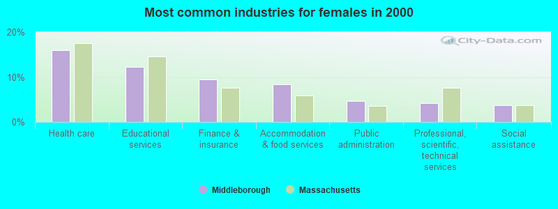
- Health care (15.9%)
- Educational services (12.3%)
- Finance & insurance (9.4%)
- Accommodation & food services (8.4%)
- Public administration (4.6%)
- Professional, scientific, technical services (4.2%)
- Social assistance (3.7%)
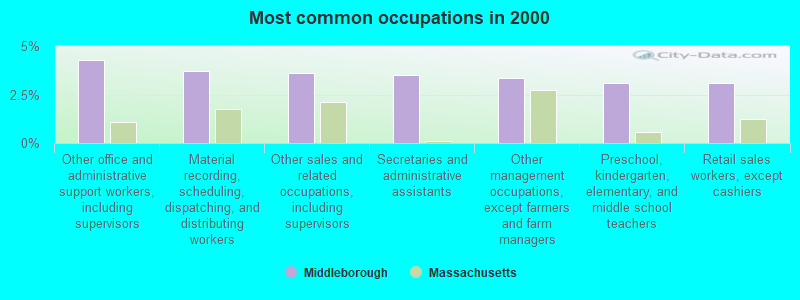
- Other office and administrative support workers, including supervisors (4.3%)
- Material recording, scheduling, dispatching, and distributing workers (3.7%)
- Other sales and related occupations, including supervisors (3.6%)
- Secretaries and administrative assistants (3.5%)
- Other management occupations, except farmers and farm managers (3.3%)
- Preschool, kindergarten, elementary, and middle school teachers (3.1%)
- Retail sales workers, except cashiers (3.1%)

- Driver/sales workers and truck drivers (5.1%)
- Electrical equipment mechanics and other installation, maintenance, and repair workers, including supervisors (4.6%)
- Construction traders workers except carpenters, electricians, painters, plumbers, and construction laborers (4.4%)
- Other sales and related occupations, including supervisors (4.2%)
- Vehicle and mobile equipment mechanics, installers, and repairers (3.9%)
- Other management occupations, except farmers and farm managers (3.7%)
- Retail sales workers, except cashiers (3.5%)

- Secretaries and administrative assistants (7.2%)
- Other office and administrative support workers, including supervisors (7.0%)
- Preschool, kindergarten, elementary, and middle school teachers (5.1%)
- Nursing, psychiatric, and home health aides (4.6%)
- Material recording, scheduling, dispatching, and distributing workers (4.1%)
- Bookkeeping, accounting, and auditing clerks (3.7%)
- Information and record clerks, except customer service representatives (3.7%)
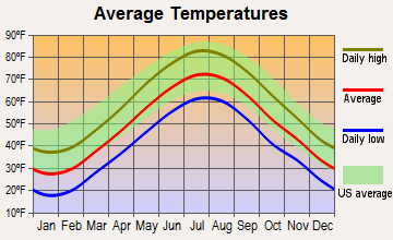
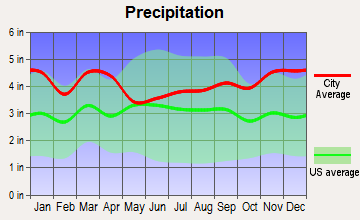
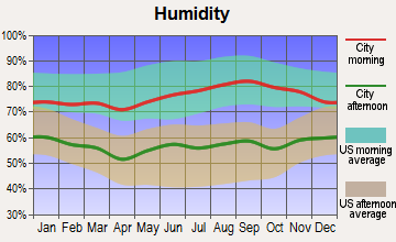
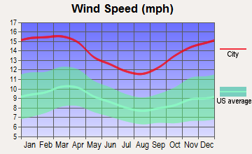
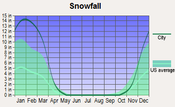
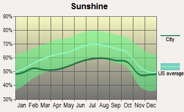
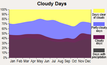
Average climate in Middleborough, Massachusetts
Based on data reported by over 4,000 weather stations
(lower is better)
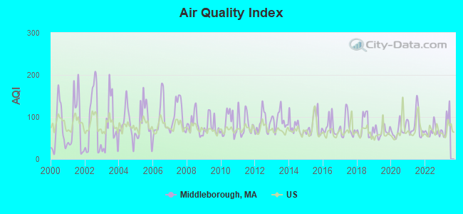
Air Quality Index (AQI) level in 2022 was 66.3. This is about average.
| City: | 66.3 |
| U.S.: | 72.6 |
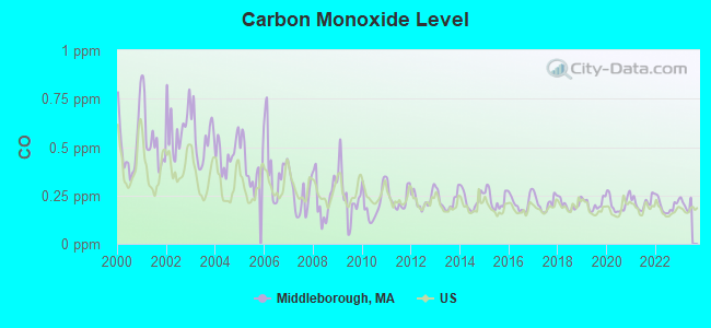
Carbon Monoxide (CO) [ppm] level in 2022 was 0.196. This is better than average. Closest monitor was 24.3 miles away from the city center.
| City: | 0.196 |
| U.S.: | 0.251 |
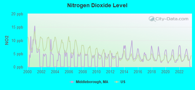
Nitrogen Dioxide (NO2) [ppb] level in 2022 was 4.16. This is better than average. Closest monitor was 10.3 miles away from the city center.
| City: | 4.16 |
| U.S.: | 5.11 |
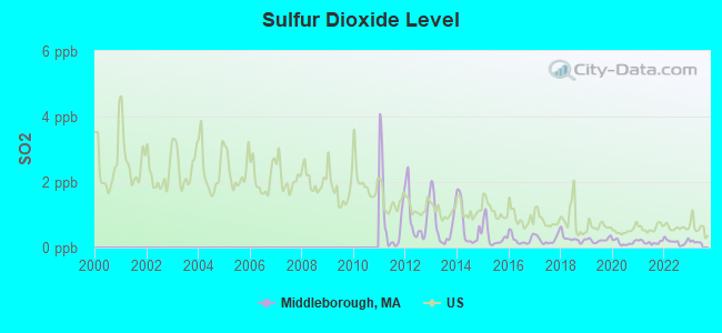
Sulfur Dioxide (SO2) [ppb] level in 2022 was 0.179. This is significantly better than average. Closest monitor was 10.3 miles away from the city center.
| City: | 0.179 |
| U.S.: | 1.515 |
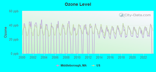
Ozone [ppb] level in 2022 was 30.5. This is about average. Closest monitor was 13.6 miles away from the city center.
| City: | 30.5 |
| U.S.: | 33.3 |
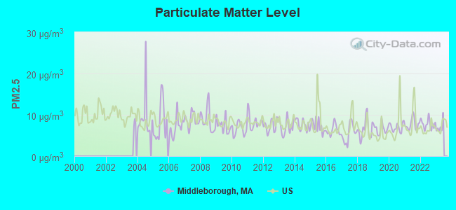
Particulate Matter (PM2.5) [µg/m3] level in 2022 was 7.77. This is about average. Closest monitor was 13.6 miles away from the city center.
| City: | 7.77 |
| U.S.: | 8.11 |
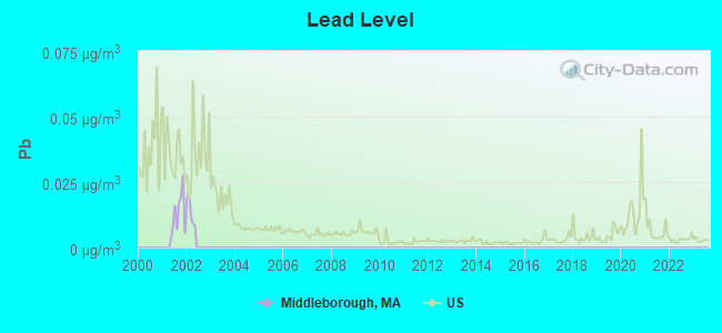
Lead (Pb) [µg/m3] level in 2001 was 0.0129. This is worse than average. Closest monitor was 14.5 miles away from the city center.
| City: | 0.0129 |
| U.S.: | 0.0093 |
Tornado activity:
Middleborough-area historical tornado activity is below Massachusetts state average. It is 64% smaller than the overall U.S. average.
On 6/9/1953, a category F3 (max. wind speeds 158-206 mph) tornado 19.3 miles away from the Middleborough town center injured 17 people and caused between $500,000 and $5,000,000 in damages.
On 6/9/1953, a category F4 (max. wind speeds 207-260 mph) tornado 42.9 miles away from the town center killed 90 people and injured 1228 people and caused between $50,000,000 and $500,000,000 in damages.
Earthquake activity:
Middleborough-area historical earthquake activity is significantly above Massachusetts state average. It is 75% smaller than the overall U.S. average.On 10/7/1983 at 10:18:46, a magnitude 5.3 (5.1 MB, 5.3 LG, 5.1 ML, Class: Moderate, Intensity: VI - VII) earthquake occurred 225.5 miles away from the city center
On 4/20/2002 at 10:50:47, a magnitude 5.3 (5.3 ML, Depth: 3.0 mi) earthquake occurred 229.9 miles away from the city center
On 1/19/1982 at 00:14:42, a magnitude 4.7 (4.5 MB, 4.7 MD, 4.5 LG, Class: Light, Intensity: IV - V) earthquake occurred 117.0 miles away from the city center
On 10/16/2012 at 23:12:25, a magnitude 4.7 (4.7 ML, Depth: 10.0 mi) earthquake occurred 118.7 miles away from the city center
On 4/20/2002 at 10:50:47, a magnitude 5.2 (5.2 MB, 4.2 MS, 5.2 MW, 5.0 MW) earthquake occurred 229.2 miles away from Middleborough center
On 8/22/1992 at 12:20:32, a magnitude 4.8 (4.8 MB, 3.8 MS, 4.7 LG, Depth: 6.2 mi) earthquake occurred 194.9 miles away from Middleborough center
Magnitude types: regional Lg-wave magnitude (LG), body-wave magnitude (MB), duration magnitude (MD), local magnitude (ML), surface-wave magnitude (MS), moment magnitude (MW)
Natural disasters:
The number of natural disasters in Plymouth County (26) is a lot greater than the US average (15).Major Disasters (Presidential) Declared: 17
Emergencies Declared: 9
Causes of natural disasters: Floods: 11, Storms: 9, Hurricanes: 7, Snows: 3, Snowstorms: 3, Blizzards: 2, Winter Storms: 2, Heavy Rain: 1, Snowfall: 1, Tropical Storm: 1, Wind: 1 (Note: some incidents may be assigned to more than one category).
Hospitals and medical centers in Middleborough:
Heliports located in Middleborough:
Operable nuclear power plant near Middleborough:
- 13 miles: Pilgrim in Plymouth, MA.
Colleges/universities with over 2000 students nearest to Middleborough:
- Bridgewater State University (about 8 miles; Bridgewater, MA; Full-time enrollment: 9,802)
- Massasoit Community College (about 14 miles; Brockton, MA; FT enrollment: 5,442)
- Stonehill College (about 16 miles; Easton, MA; FT enrollment: 2,563)
- Bristol Community College (about 17 miles; Fall River, MA; FT enrollment: 5,707)
- University of Massachusetts-Dartmouth (about 19 miles; North Dartmouth, MA; FT enrollment: 7,545)
- Roger Williams University (about 26 miles; Bristol, RI; FT enrollment: 4,375)
- Quincy College (about 26 miles; Quincy, MA; FT enrollment: 3,184)
Public high school in Middleborough:
- MIDDLEBOROUGH HIGH (Students: 937, Location: 71 EAST GROVE STREET, Grades: 9-12)
Public elementary/middle schools in Middleborough:
- HENRY B. BURKLAND ELEMENTARY SCHOOL (Students: 884, Location: 41 MAYFLOWER AVENUE, Grades: 1-5)
- JOHN T. NICHOLS MIDDLE (Students: 868, Location: 112 TIGER DRIVE, Grades: 6-8)
- MARY K. GOODE ELEMENTARY SCHOOL (Students: 565, Location: 31 MAYFLOWER AVENUE, Grades: 1-5)
Library in Middleborough:
- MIDDLEBOROUGH PUBLIC LIBRARY (Operating income: $656,997; Location: 102 NORTH MAIN ST.; 88,159 books; 523 e-books; 6,070 audio materials; 5,782 video materials; 3 local licensed databases; 34 state licensed databases; 1 other licensed databases; 195 print serial subscriptions; 1 electronic serial subscriptions)
Points of interest:
Notable locations in Middleborough: Titicut (A), Middleborough Waterworks (B), Middleborough Fire Department Station 3 (C), Middleborough Townhall (D), Middleborough Fire Department Station 1 Headquarters (E), Middleborough Fire Department Station 2 (F), Middleborough Public Library (G), Middleborough Town Hall (H). Display/hide their locations on the map
Churches in Middleborough include: Unitarian Universalist Church (A), Rock Village Church (B), North Congregational Church (C), Middleboro United Methodist Church (D), First Congregational Church (E), First Church of Christ Scientist (F), Church of Our Saviour Church (G), Church in Middleborough (H), Christ Evangelical Church (I). Display/hide their locations on the map
Cemeteries: Thomastown Cemetery (1), Reed Cemetery (2), Perchade Cemetery (3), Central Cemetery (4), Saint Marys Cemetery (5), Nemasket Hill Cemetery (6), Parish Cemetery (7). Display/hide their locations on the map
Lakes, reservoirs, and swamps: Joses Meadow (A), Nevertouch Pond (B), Pocksha Pond (C), Tispaquin Pond (D), Beaton - Lebaron Bog Reservoir (E), Fisher Bog Reservoir (F), Rocky Meadow Bog Reservoir (G), Maxim Corner Pond (H). Display/hide their locations on the map
Streams, rivers, and creeks: Shaving Brook (A), Purchade Brook (B), Poquoy Brook (C), Otis Pratt Brook (D), Fall Brook (E), Danson Brook (F), Beaverdam Brook (G), Millers Neck Brook (H), Shorts Brook (I). Display/hide their locations on the map
Parks in Middleborough include: Rocky Gutter Wildlife Management Area (1), Rocky Gutter Wildlife Area (2), Camp Yomechas (3), Camp Avoda (4). Display/hide their locations on the map
Birthplace of: Ebenezer Sproat - Continental Army officer, Lavinia Warren - Midget, Samuel Breck (general) - Adjutant General of the Army, Enoch Pratt - Businessman, Corey Carrier - Child actor, Gabriel Mercier - Soccer player, John C. Bradford - Politician.
Drinking water stations with addresses in Middleborough and their reported violations in the past:
MIDDLEBOROUGH WATER SUPPLY (Population served: 15,900, Groundwater):Past health violations:TWIN COACH / EDGEWAY MOBILE HOMES (Population served: 134, Groundwater):Past monitoring violations:
- MCL, Monthly (TCR) - In OCT-2005, Contaminant: Coliform. Follow-up actions: St AO (w/o penalty) issued (MAY-18-2006), St Compliance achieved (MAY-18-2006)
- Follow-up Or Routine LCR Tap M/R - In OCT-01-2006, Contaminant: Lead and Copper Rule. Follow-up actions: St AO (w/o penalty) issued (NOV-30-2006), St Compliance achieved (OCT-22-2007)
Past monitoring violations:NEMASKET HEALTH CARE CENTER (Population served: 90, Groundwater):
- 8 routine major monitoring violations
- 13 regular monitoring violations
Past health violations:Past monitoring violations:
- MCL, Monthly (TCR) - In JUL-2009, Contaminant: Coliform. Follow-up actions: St AO (w/o penalty) issued (DEC-07-2009), St Compliance achieved (DEC-07-2009)
- MCL, Monthly (TCR) - In JUN-2009, Contaminant: Coliform. Follow-up actions: St AO (w/o penalty) issued (DEC-07-2009), St Compliance achieved (DEC-07-2009)
- MCL, Monthly (TCR) - In DEC-2006, Contaminant: Coliform. Follow-up actions: St AO (w/o penalty) issued (JUN-20-2007), St Compliance achieved (JUN-20-2007)
- MCL, Monthly (TCR) - In NOV-2006, Contaminant: Coliform. Follow-up actions: St AO (w/o penalty) issued (JUN-20-2007), St Compliance achieved (JUN-20-2007)
- MCL, Monthly (TCR) - In SEP-2006, Contaminant: Coliform. Follow-up actions: St AO (w/o penalty) issued (JUN-20-2007), St Compliance achieved (JUN-20-2007)
- Notification, State - In JUL-2009, Contaminant: Coliform (TCR). Follow-up actions: St AO (w/o penalty) issued (DEC-07-2009), St Compliance achieved (DEC-07-2009)
- Notification, Public - In SEP-2006, Contaminant: Coliform (TCR). Follow-up actions: St AO (w/o penalty) issued (JUN-20-2007), St Compliance achieved (JUN-20-2007)
| This town: | 2.7 people |
| Massachusetts: | 2.5 people |
| This town: | 72.2% |
| Whole state: | 63.0% |
| This town: | 8.4% |
| Whole state: | 7.0% |
Likely homosexual households (counted as self-reported same-sex unmarried-partner households)
- Lesbian couples: 0.6% of all households
- Gay men: 0.3% of all households
| This town: | 5.5% |
| Whole state: | 9.3% |
| This town: | 2.2% |
| Whole state: | 4.4% |
People in group quarters in Middleborough in 2010:
- 387 people in nursing facilities/skilled-nursing facilities
- 74 people in group homes for juveniles (non-correctional)
- 28 people in emergency and transitional shelters (with sleeping facilities) for people experiencing homelessness
- 13 people in group homes intended for adults
- 5 people in residential schools for people with disabilities
- 3 people in workers' group living quarters and job corps centers
- 3 people in other noninstitutional facilities
People in group quarters in Middleborough in 2000:
- 373 people in nursing homes
- 82 people in other noninstitutional group quarters
- 27 people in residential treatment centers for emotionally disturbed children
- 24 people in mental (psychiatric) hospitals or wards
- 21 people in homes for the mentally retarded
- 4 people in religious group quarters
For population 15 years and over in Middleborough:

- Never married: 24.7%
- Now married: 55.3%
- Separated: 1.9%
- Widowed: 6.7%
- Divorced: 11.3%
For population 25 years and over in Middleborough:
- High school or higher: 86.0%
- Bachelor's degree or higher: 19.6%
- Graduate or professional degree: 5.3%
- Unemployed: 3.8%
- Mean travel time to work (commute): 30.5 minutes
| Here: | 9.5 |
| Massachusetts average: | 13.1 |


Graphs represent county-level data. Detailed 2008 Election Results
Religion statistics for Middleborough, MA (based on Plymouth County data)


| Religion | Adherents | Congregations |
|---|---|---|
| Catholic | 165,985 | 35 |
| Mainline Protestant | 23,724 | 91 |
| Evangelical Protestant | 13,159 | 96 |
| Other | 6,129 | 43 |
| Orthodox | 1,140 | 3 |
| Black Protestant | 611 | 5 |
| None | 284,171 | - |
Food Environment Statistics:
| This county: | 1.74 / 10,000 pop. |
| State: | 1.98 / 10,000 pop. |
| Here: | 0.04 / 10,000 pop. |
| Massachusetts: | 0.05 / 10,000 pop. |
| This county: | 2.84 / 10,000 pop. |
| Massachusetts: | 2.22 / 10,000 pop. |
| Plymouth County: | 2.20 / 10,000 pop. |
| Massachusetts: | 1.77 / 10,000 pop. |
| This county: | 7.37 / 10,000 pop. |
| Massachusetts: | 8.76 / 10,000 pop. |
| This county: | 7.9% |
| State: | 8.1% |
| Here: | 21.7% |
| Massachusetts: | 22.5% |
| Plymouth County: | 16.3% |
| Massachusetts: | 16.5% |
5.54% of this county's 2020 resident taxpayers moved to other counties in 2021 ($85,482 average adjusted gross income)
| Here: | 5.54% |
| Massachusetts average: | 7.18% |
0.01% of residents moved to foreign countries ($80 average AGI)
Plymouth County: 0.01% Massachusetts average: 0.02%
Top counties to which taxpayers relocated from this county between 2020 and 2021:
| to Bristol County, MA | |
| to Norfolk County, MA | |
| to Suffolk County, MA |
Businesses in Middleborough, MA
- Subway: 2
Strongest AM radio stations in Middleborough:
- WBZ (1030 AM; 50 kW; BOSTON, MA; Owner: INFINITY BROADCASTING OPERATIONS, INC.)
- WVBF (1530 AM; 1 kW; MIDDLEBOROUGH CENTER, MA; Owner: STEVEN J. CALLAHAN)
- WEEI (850 AM; 50 kW; BOSTON, MA; Owner: ENTERCOM BOSTON LICENSE, LLC)
- WALE (990 AM; 50 kW; GREENVILLE, RI; Owner: NORTH AMERICAN BROADCASTING CO., INC.)
- WRKO (680 AM; 50 kW; BOSTON, MA; Owner: ENTERCOM BOSTON LICENSE, LLC)
- WPLM (1390 AM; 5 kW; PLYMOUTH, MA; Owner: PLYMOUTH ROCK BROADCASTING CO., INC.)
- WKOX (1200 AM; 50 kW; FRAMINGHAM, MA; Owner: CAPSTAR TX LIMITED PARTNERSHIP)
- WBIX (1060 AM; 40 kW; NATICK, MA; Owner: LANGER BROADCASTING CORPORATION)
- WWZN (1510 AM; 50 kW; BOSTON, MA; Owner: ROSE CITY RADIO CORPORATION)
- WAMG (890 AM; 25 kW; DEDHAM, MA; Owner: MEGA COMMUNICATIONS OF DEDHAM LICENSEE, LLC)
- WBET (1460 AM; 5 kW; BROCKTON, MA; Owner: KJI BROADCASTING, LLC)
- WCRN (830 AM; 50 kW; WORCESTER, MA; Owner: CARTER BROADCASTING CORPORATION)
- WRCA (1330 AM; 25 kW; WALTHAM, MA; Owner: WRCA LICENSE, LLC)
Strongest FM radio stations in Middleborough:
- WPLM-FM (99.1 FM; PLYMOUTH, MA; Owner: PLYMOUTH ROCK BROADCASTING CO., INC.)
- WWBB (101.5 FM; PROVIDENCE, RI; Owner: CLEAR CHANNEL BROADCASTING LICENSES, INC.)
- WBOT (97.7 FM; BROCKTON, MA; Owner: RADIO ONE LICENSES, LLC)
- WXKS-FM (107.9 FM; MEDFORD, MA; Owner: AMFM RADIO LICENSES, L.L.C.)
- WSNE-FM (93.3 FM; TAUNTON, MA; Owner: CAPSTAR TX LIMITED PARTNERSHIP)
- WJFD-FM (97.3 FM; NEW BEDFORD, MA; Owner: EDMUND DINIS, TRUSTEE)
- WBMX (98.5 FM; BOSTON, MA; Owner: INFINITY RADIO OPERATIONS INC.)
- WMJX (106.7 FM; BOSTON, MA; Owner: GREATER BOSTON RADIO, INC.)
- WBOS (92.9 FM; BROOKLINE, MA; Owner: GREATER BOSTON RADIO, INC.)
- WJMN (94.5 FM; BOSTON, MA; Owner: AMFM RADIO LICENSES, L.L.C.)
- WCRB (102.5 FM; WALTHAM, MA; Owner: CHARLES RIVER BROADCASTING WCRB LICE)
- WTKK (96.9 FM; BOSTON, MA; Owner: GREATER BOSTON RADIO, INC.)
- WROR-FM (105.7 FM; FRAMINGHAM, MA; Owner: GREATER BOSTON RADIO, INC.)
- WCTK (98.1 FM; NEW BEDFORD, MA; Owner: HALL COMMUNICATIONS, INC.)
- WATD-FM (95.9 FM; MARSHFIELD, MA; Owner: MARSHFIELD BROADCASTING CO., INC.)
- WGBH (89.7 FM; BOSTON, MA; Owner: WGBH EDUCATIONAL FOUNDATION)
- WBUR-FM (90.9 FM; BOSTON, MA; Owner: TRUSTEES OF BOSTON UNIVERSITY)
- WODS (103.3 FM; BOSTON, MA; Owner: INFINITY BROADCASTING OPERATIONS, INC.)
- WFHN (107.1 FM; FAIRHAVEN, MA; Owner: CITADEL BROADCASTING COMPANY)
- WBCN (104.1 FM; BOSTON, MA; Owner: HEMISPHERE BROADCASTING CORPORATION)
TV broadcast stations around Middleborough:
- WLWC (Channel 28; NEW BEDFORD, MA; Owner: C-28 FCC LICENSEE SUBSIDIARY, LLC)
- WWDP (Channel 46; NORWELL, MA; Owner: NORWELL TELEVISION, LLC)
- WLNE-TV (Channel 6; NEW BEDFORD, MA; Owner: FREEDOM BROADCASTING OF SOUTHERN NEW ENGLAND, INC.)
- WPRI-TV (Channel 12; PROVIDENCE, RI; Owner: TVL BROADCASTING OF RHODE ISLAND, LLC)
- WNAC-TV (Channel 64; PROVIDENCE, RI; Owner: WNAC, LLC)
- WJAR (Channel 10; PROVIDENCE, RI; Owner: OUTLET BROADCASTING, INC.)
- WCVB-TV (Channel 5; BOSTON, MA; Owner: WCVB HEARST-ARGYLE TV, INC.)
- WGBH-TV (Channel 2; BOSTON, MA; Owner: WGBH EDUCATIONAL FOUNDATION)
- WSBE-TV (Channel 36; PROVIDENCE, RI; Owner: RHODE ISLAND PUBLIC TELECOM. AUTHORITY)
- WHDH-TV (Channel 7; BOSTON, MA; Owner: WHDH-TV)
- WMFP (Channel 62; LAWRENCE, MA; Owner: WSAH LICENSE, INC.)
- WSBK-TV (Channel 38; BOSTON, MA; Owner: VIACOM INC.)
- WLVI-TV (Channel 56; CAMBRIDGE, MA; Owner: WLVI, INC.)
- WBZ-TV (Channel 4; BOSTON, MA; Owner: VIACOM INC.)
- WGBX-TV (Channel 44; BOSTON, MA; Owner: WGBH EDUCATIONAL FOUNDATION)
- WFXT (Channel 25; BOSTON, MA; Owner: FOX TELEVISION STATIONS INC.)
- WBPX (Channel 68; BOSTON, MA; Owner: PAXSON BOSTON-68 LICENSE, INC.)
- W40BO (Channel 40; BOSTON, MA; Owner: PAXSON COMMUNICATIONS LPTV, INC.)
- WPXQ (Channel 69; BLOCK ISLAND, RI; Owner: OCEAN STATE TELEVISION, L.L.C.)
- WTMU-LP (Channel 32; BOSTON, MA; Owner: ZGS BOSTON, INC.)
- WCEA-LP (Channel 58; BOSTON, MA; Owner: CHANNEL 19 TV CORPORATION)
- WUTF (Channel 66; MARLBOROUGH, MA; Owner: TELEFUTURA BOSTON LLC)
- National Bridge Inventory (NBI) Statistics
- 42Number of bridges
- 364ft / 111mTotal length
- $85,162,000Total costs
- 709,072Total average daily traffic
- 25,117Total average daily truck traffic
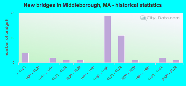
- New bridges - historical statistics
- 4Before 1900
- 21910-1919
- 11920-1929
- 11930-1939
- 191950-1959
- 111960-1969
- 11970-1979
- 21990-1999
- 12000-2009
FCC Registered Antenna Towers:
35 (See the full list of FCC Registered Antenna Towers in Middleborough)FCC Registered Private Land Mobile Towers:
1- 426 Wareham St. (Lat: 41.848444 Lon: -70.852250), Type: Tower, Structure height: 46 m, Call Sign: WPLA751,
Assigned Frequencies: 862.012 MHz, 862.037 MHz, 862.062 MHz, 862.087 MHz, 862.112 MHz, 862.137 MHz, 862.162 MHz, 862.187 MHz, 862.212 MHz, 862.237 MHz... (+150 more), Grant Date: 02/28/2012, Expiration Date: 02/06/2022, Cancellation Date: 08/22/2012, Registrant: Sprint Nextel Corporation, 2001 Edmund Halley Drive, Reston, VA 20191, Phone: (703) 433-4000, Fax: (703) 433-4483
FCC Registered Broadcast Land Mobile Towers:
6- 326 W Grove St (Lat: 41.893167 Lon: -70.941694), Type: Building, Structure height: 4 m, Overall height: 5 m, Call Sign: WPKG914,
Assigned Frequencies: 485.462 MHz, Grant Date: 12/07/2021, Expiration Date: 02/18/2032, Certifier: Donald C Nagle Jr, Registrant: Ma Commonwealth Of, 470 Worcester Rd, Framingham, MA 01702, Phone: (774) 462-3767, Fax: (774) 462-3768, Email:
- MIDDLEBOROUGH S.P., West Grove St Rt 28 (Lat: 41.893111 Lon: -70.943056), Type: Tower, Structure height: 100.6 m, Overall height: 106.1 m, Call Sign: WPUN397,
Assigned Frequencies: 42.4400 MHz, 158.970 MHz, 42.5000 MHz, Grant Date: 02/02/2022, Expiration Date: 04/01/2032, Certifier: Richard P Hanlon, Registrant: Massachusetts, Commonwealth Of Department Of State Police, 470 Worcester Rd, Framingham, MA 01702, Phone: (774) 462-3767, Email:
- Lat: 41.901722 Lon: -70.915944, Call Sign: WQBF243,
Assigned Frequencies: 160.110 MHz, Grant Date: 08/08/2014, Expiration Date: 09/29/2024, Certifier: Andrew Healy, Registrant: Blooston, Mordkofsky, Dickens, Duffy & Prendergast, LLP, 2120 L Street, N.W., Suite 300, Washington, DC 20037, Phone: (202) 828-5565, Fax: (202) 828-5568
- Lat: 41.894333 Lon: -70.914722, Call Sign: WQID726,
Assigned Frequencies: 456.712 MHz, 462.237 MHz, 464.775 MHz, 468.687 MHz, 469.775 MHz, Grant Date: 01/26/2018, Expiration Date: 01/14/2028, Certifier: Andrew Healy, Registrant: Comtronics/Bearcom, 1230 Furnace Brook Pkwy., Quincy, MA 02169, Phone: (617) 770-0212, Fax: (617) 770-0429, Email:
- SACHEM STREET TANK, Sachem Street 1.5 Mg Storage Tank (Lat: 41.888611 Lon: -70.889444), Type: Tank, Structure height: 37 m, Overall height: 41 m, Call Sign: WQNU529,
Assigned Frequencies: 218.475 MHz, Grant Date: 03/16/2021, Expiration Date: 05/31/2031, Certifier: Joseph M Silva, Registrant: Tcs Communications Corp, Salisbury, MA 01952, Phone: (978) 465-7932, Fax: (978) 462-8980, Email:
- Lat: 41.907944 Lon: -70.955583, Call Sign: WRFL405,
Assigned Frequencies: 451.450 MHz, 456.450 MHz, 462.250 MHz, 464.137 MHz, 464.887 MHz, 464.962 MHz, 467.250 MHz, 469.137 MHz, 469.887 MHz, 469.962 MHz, Grant Date: 03/24/2020, Expiration Date: 03/24/2030, Certifier: Patrick Mchugh, Registrant: Bearcom, 4009 Distribution Drive, Bldg 200, Garland, TX 75041, Phone: (214) 765-7328, Email:
FCC Registered Microwave Towers:
5- GROVE ST, Middleborough, Highway 28 & West Grove St. (Lat: 41.893278 Lon: -70.942972), Type: Gtower, Structure height: 100.6 m, Overall height: 106.1 m, Call Sign: WNTY841,
Assigned Frequencies: 6765.00 MHz, 6545.62 MHz, 6630.62 MHz, 6655.62 MHz, 5945.20 MHz, 5974.85 MHz, 5945.20 MHz, 5974.85 MHz, 5945.20 MHz, 5974.85 MHz, 5945.20 MHz, 5974.85 MHz, Grant Date: 06/08/2018, Expiration Date: 08/28/2028, Registrant: Massachusetts State Police, 470 Worchester Rd, Framingham, MA 01702, Phone: (508) 820-2222, Email:
- Pine St, Tower Off Of 121 Pine St. (Lat: 41.826639 Lon: -70.809750), Type: Ltower, Structure height: 57.9 m, Call Sign: WRAK948,
Assigned Frequencies: 11645.0 MHz, 11645.0 MHz, 11645.0 MHz, 11645.0 MHz, 11645.0 MHz, 11645.0 MHz, 11645.0 MHz, 11645.0 MHz, 11645.0 MHz, 11645.0 MHz, Grant Date: 12/19/2017, Expiration Date: 12/19/2027, Certifier: Lance Benjamino, Registrant: All-Comm Technologies, Inc., 5 Whitmore Rd., Revere, MA 02151, Phone: (781) 983-1699, Fax: (781) 289-7300, Email:
- Katrina Rd, Tower Off Of 300 Katrina Rd (Lat: 41.912000 Lon: -70.870389), Type: Ltower, Structure height: 57.9 m, Call Sign: WRAL462,
Assigned Frequencies: 11565.0 MHz, 18060.0 MHz, 11565.0 MHz, 18060.0 MHz, 11565.0 MHz, 18060.0 MHz, 11565.0 MHz, 18060.0 MHz, 11565.0 MHz, 18060.0 MHz... (+10 more), Grant Date: 12/22/2017, Expiration Date: 12/22/2027, Certifier: Lance Benjamino, Registrant: All-Comm Technologies, Inc., 5 Whitmore Rd., Revere, MA 02151, Phone: (781) 983-1699, Fax: (781) 289-7300, Email:
- Police Station, Tower Off Of 300 Wood St (Lat: 41.905083 Lon: -70.884000), Type: Mtower, Structure height: 38.1 m, Overall height: 39.6 m, Call Sign: WRAL463,
Assigned Frequencies: 19620.0 MHz, 19620.0 MHz, 19620.0 MHz, 19620.0 MHz, 19620.0 MHz, 19620.0 MHz, 19620.0 MHz, 19620.0 MHz, 19620.0 MHz, 19620.0 MHz, Grant Date: 12/22/2017, Expiration Date: 12/22/2027, Certifier: Lance Benjamino, Registrant: All-Comm Technologies, Inc., 5 Whitmore Rd., Revere, MA 02151, Phone: (781) 983-1699, Fax: (781) 289-7300, Email:
- MIDDLEBORO, 259 East Grove Street (Lat: 41.869083 Lon: -70.882361), Type: Ltower, Structure height: 55.8 m, Overall height: 56.4 m, Call Sign: WLT354,
Assigned Frequencies: 6152.75 MHz, 10715.0 MHz, Grant Date: 01/11/2011, Expiration Date: 02/01/2021, Cancellation Date: 01/12/2016, Certifier: Carol L Tacker, Registrant: At&t Mobility LLC, 3300 E. Renner Road, B3132, Richardson, TX 75082, Phone: (855) 699-7073, Fax: (972) 907-1131, Email:
FCC Registered Amateur Radio Licenses:
11 (See the full list of FCC Registered Amateur Radio Licenses in Middleborough)2002 - 2018 National Fire Incident Reporting System (NFIRS) incidents
- Fire incident types reported to NFIRS in Middleborough, MA
- 75743.5%Outside Fires
- 55732.0%Structure Fires
- 36521.0%Mobile Property/Vehicle Fires
- 613.5%Other
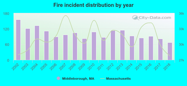 According to the data from the years 2002 - 2018 the average number of fire incidents per year is 102. The highest number of fire incidents - 156 took place in 2002, and the least - 67 in 2018. The data has a declining trend.
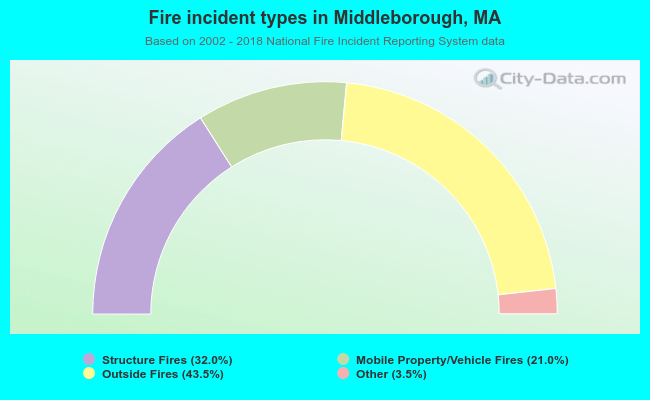 When looking into fire subcategories, the most incidents belonged to: Outside Fires (43.5%), and Structure Fires (32.0%).
- 65.8%Fuel oil, kerosene, etc.
- 27.2%Utility gas
- 3.2%Bottled, tank, or LP gas
- 2.0%Wood
- 1.3%Electricity
- 0.4%Other fuel
- 51.7%Utility gas
- 33.3%Fuel oil, kerosene, etc.
- 7.2%Electricity
- 5.2%Bottled, tank, or LP gas
- 1.9%No fuel used
- 0.7%Other fuel
Middleborough compared to Massachusetts state average:
- Unemployed percentage significantly below state average.
- Black race population percentage significantly below state average.
- Hispanic race population percentage significantly below state average.
- Foreign-born population percentage significantly below state average.
- Renting percentage below state average.
- Length of stay since moving in significantly above state average.
- Number of rooms per house significantly below state average.
- House age significantly below state average.
- Percentage of population with a bachelor's degree or higher below state average.
Middleborough on our top lists:
- #30 on the list of "Top 101 cities with largest percentage of females in industries: alcoholic beverages merchant wholesalers (population 5,000+)"
- #35 on the list of "Top 101 cities with largest percentage of females in industries: leather and allied products (population 5,000+)"
- #39 on the list of "Top 101 cities with largest percentage of males in industries: printing and related support activities (population 5,000+)"
- #45 on the list of "Top 101 cities with largest percentage of females in industries: electronic shopping and mail-order houses (population 5,000+)"
- #46 on the list of "Top 101 cities with largest percentage of males in occupations: printing workers (population 5,000+)"
- #46 on the list of "Top 101 cities with largest percentage of females in industries: paper (population 5,000+)"
- #50 on the list of "Top 101 cities with largest percentage of males in industries: motor vehicle and parts dealers (population 5,000+)"
- #51 on the list of "Top 101 cities with largest percentage of females in industries: clothing and accessories, including shoe, stores (population 5,000+)"
- #64 on the list of "Top 101 cities with largest percentage of males in occupations: occupational and physical therapist assistants and aides (population 5,000+)"
- #83 on the list of "Top 101 cities with largest percentage of females in occupations: material recording, scheduling, dispatching, and distributing workers (population 5,000+)"
- #90 on the list of "Top 101 cities with largest percentage of females in industries: printing and related support activities (population 5,000+)"
- #91 on the list of "Top 101 cities with the largest percentage of people in residential treatment centers for emotionally disturbed children (population 1,000+)"
- #92 on the list of "Top 101 cities with largest percentage of males in occupations: registered nurses (population 5,000+)"
- #94 on the list of "Top 101 cities with largest percentage of females in industries: warehousing and storage (population 5,000+)"
- #95 on the list of "Top 101 cities with largest percentage of males in occupations: other food preparation and serving workers including supervisors (population 5,000+)"
- #100 on the list of "Top 101 cities with largest percentage of males in occupations: air transportation workers (population 5,000+)"
- #18 on the list of "Top 101 counties with the highest percentage of residents that visited a dentist within the past year"
- #24 on the list of "Top 101 counties with the highest percentage of residents that smoked 100+ cigarettes in their lives"
- #35 on the list of "Top 101 counties with the largest decrease in the number of births per 1000 residents 2000-2006 to 2007-2013 (pop 50,000+)"
- #39 on the list of "Top 101 counties with the lowest percentage of residents that keep firearms around their homes"
- #39 on the list of "Top 101 counties with the lowest number of infant deaths per 1000 residents 2007-2013 (pop. 50,000+)"

|
|
Total of 25 patent applications in 2008-2024.