Carver, Massachusetts
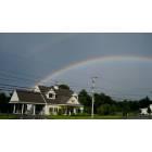
Carver
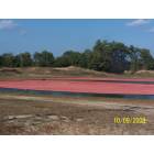
Carver: Cranberry bogs
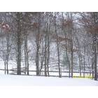
Carver: Winter Wonderland
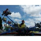
Carver: Edaville Railroad
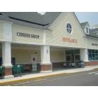
Carver: Shaw's plaza Shopping Center 100 N Main Street
- add
your
Submit your own pictures of this town and show them to the world
- OSM Map
- General Map
- Google Map
- MSN Map
Population change since 2000: +3.1%
 |
| Males: 5,610 | |
| Females: 5,899 |
| Median resident age: | 42.3 years |
| Massachusetts median age: | 39.2 years |
Zip codes: 02330.
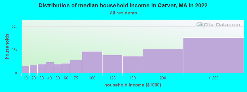
| Carver: | $99,261 |
| MA: | $94,488 |
Estimated per capita income in 2022: $44,569 (it was $20,398 in 2000)
Carver town income, earnings, and wages data
Estimated median house or condo value in 2022: $461,841 (it was $148,300 in 2000)
| Carver: | $461,841 |
| MA: | $534,700 |
Mean prices in 2022: all housing units: $585,203; detached houses: $620,100; townhouses or other attached units: $487,972; in 2-unit structures: $464,355; in 3-to-4-unit structures: $429,583; in 5-or-more-unit structures: $438,441; mobile homes: $207,706; occupied boats, rvs, vans, etc.: $17,153
Detailed information about poverty and poor residents in Carver, MA

Compare current foreclosures near Carver, MA:
| Photo | Address | Area | Beds / Baths | Price | Details |
|---|---|---|---|---|---|

|
#1
Bow St
Carver, MA 02330
|
2,728 sq. feet
|
3 baths 4 beds |
show details | |

|
#2
Leonard St
Carver, MA 02330
|
1,132 sq. feet
|
2 baths 3 beds |
show details | |

|
#3
Shaw Rd
Carver, MA 02330
|
5,021 sq. feet
|
4 baths 7 beds |
show details | |

|
#4
Crystal Lake Dr
Carver, MA 02330
|
744 sq. feet
|
1 baths 2 beds |
show details | |

|
#5
Ba Dr
Carver, MA 02330
|
2,266 sq. feet
|
2 baths 3 beds |
show details | |

|
#6
Tremont St
Carver, MA 02330
|
1,776 sq. feet
|
2 baths 6 beds |
show details | |

|
#7
S Meadow Rd
Carver, MA 02330
|
1,132 sq. feet
|
1 baths 3 beds |
show details | |

|
#8
Purchase St
Carver, MA 02330
|
960 sq. feet
|
1 baths 3 beds |
show details | |

|
#9
Heritage Ln
Duxbury, MA 02332
|
5,508 sq. feet
|
2 baths 5 beds |
$759,900
|
show details |

|
#10
County St
East Taunton, MA 02718
|
1,157 sq. feet
|
1 baths 1 beds |
$219,900
|
show details |
| Photo | Address | Area | Beds / Baths | Price | Details |
|---|---|---|---|---|---|

|
#11
Winter St
Hanson, MA 02341
|
1,844 sq. feet
|
3 baths 3 beds |
show details | |

|
#12
Point Rd
Marion, MA 02738
|
660 sq. feet
|
1 baths 2 beds |
show details | |

|
#13
Hubbard Rd
East Bridgewater, MA 02333
|
1,344 sq. feet
|
2 baths 4 beds |
show details | |

|
#14
Holly Cir # 16a
Buzzards Bay, MA 02532
|
1,451 sq. feet
|
1 baths 3 beds |
show details | |

|
#15
Homestead Ave
Acushnet, MA 02743
|
936 sq. feet
|
1 baths 3 beds |
show details | |

|
#16
State Rd
Plymouth, MA 02360
|
1,836 sq. feet
|
2 baths 2 beds |
show details | |

|
#17
Erin Ct
New Bedford, MA 02745
|
1,814 sq. feet
|
2 baths 3 beds |
show details | |

|
#18
Pond St
East Bridgewater, MA 02333
|
864 sq. feet
|
1 baths 2 beds |
show details | |

|
#19
Carriage House Dr
Bridgewater, MA 02324
|
2,282 sq. feet
|
2 baths 3 beds |
show details | |

|
#20
Tananger Rd
Plymouth, MA 02360
|
1,836 sq. feet
|
3 baths 3 beds |
show details |
| Photo | Address | Area | Beds / Baths | Price | Details |
|---|---|---|---|---|---|

|
#21
Goldfinch Ln
Plymouth, MA 02360
|
777 sq. feet
|
1 baths 3 beds |
show details | |

|
#22
Great Cedar Dr # 4
Hanson, MA 02341
|
- sq. feet
|
1 baths 2 beds |
show details | |

|
#23
N Main St
Middleboro, MA 02346
|
1,898 sq. feet
|
2 baths 4 beds |
show details | |

|
#24
Bedford St
Bridgewater, MA 02324
|
1,030 sq. feet
|
1 baths 2 beds |
show details | |

|
#25
Laura Ln
Mattapoisett, MA 02739
|
2,128 sq. feet
|
2 baths 4 beds |
show details | |

|
#26
Pond St
East Bridgewater, MA 02333
|
864 sq. feet
|
1 baths 2 beds |
show details | |

|
#27
Kimba Ln
Sagamore Beach, MA 02562
|
3,384 sq. feet
|
3 baths 5 beds |
show details | |

|
#28
Sycamore Ave
Sagamore Beach, MA 02562
|
3,484 sq. feet
|
2 baths 7 beds |
show details | |

|
#29
Lillian St
East Bridgewater, MA 02333
|
864 sq. feet
|
1 baths 2 beds |
show details | |

|
#30
School St
Pembroke, MA 02359
|
690 sq. feet
|
1 baths 1 beds |
show details |
| Photo | Address | Area | Beds / Baths | Price | Details |
|---|---|---|---|---|---|

|
#31
Center St
Pembroke, MA 02359
|
1,200 sq. feet
|
1 baths 4 beds |
show details | |

|
#32
Holloway St
Berkley, MA 02779
|
1,056 sq. feet
|
1 baths 3 beds |
show details | |

|
#33
Pine Ridge Ln
Mattapoisett, MA 02739
|
3,831 sq. feet
|
2 baths 4 beds |
show details | |

|
#34
Braley Rd
East Freetown, MA 02717
|
819 sq. feet
|
1 baths 2 beds |
show details | |

|
#35
Howland Rd
Lakeville, MA 02347
|
1,447 sq. feet
|
1 baths 3 beds |
show details | |

|
#36
Parker Rd
Pembroke, MA 02359
|
1,696 sq. feet
|
3 baths 3 beds |
show details | |

|
#37
Plain St
Bridgewater, MA 02324
|
1,104 sq. feet
|
1 baths 3 beds |
show details | |

|
#38
Cherokee St
New Bedford, MA 02745
|
1,000 sq. feet
|
2 baths 3 beds |
show details | |

|
#39
Meadow Lark Ln
Sagamore Beach, MA 02562
|
1,260 sq. feet
|
1 baths 3 beds |
show details | |

|
#40
Lils Way
Mattapoisett, MA 02739
|
1,404 sq. feet
|
1 baths 3 beds |
show details |
| Photo | Address | Area | Beds / Baths | Price | Details |
|---|---|---|---|---|---|

|
#41
Josephs Way
New Bedford, MA 02745
|
1,538 sq. feet
|
2 baths 3 beds |
show details | |

|
#42
Summer St
Bridgewater, MA 02324
|
1,380 sq. feet
|
1 baths 2 beds |
show details | |

|
#43
Bay Pond Rd
Duxbury, MA 02332
|
5,822 sq. feet
|
4 baths 5 beds |
show details | |

|
#44
Cottonwood Rd
New Bedford, MA 02745
|
1,484 sq. feet
|
2 baths 3 beds |
show details | |

|
#45
Meeting Square Dr
Bridgewater, MA 02324
|
2,292 sq. feet
|
2 baths 4 beds |
show details | |

|
#46
Appletree Cir
Bridgewater, MA 02324
|
1,196 sq. feet
|
1 baths 3 beds |
show details | |

|
#47
Powhattan Dr
East Taunton, MA 02718
|
1,632 sq. feet
|
1 baths 3 beds |
show details | |

|
#48
Lark St
New Bedford, MA 02745
|
1,274 sq. feet
|
1 baths 3 beds |
show details | |

|
#49
Pequot St
New Bedford, MA 02745
|
1,574 sq. feet
|
1 baths 3 beds |
show details | |

|
Check over 1 million property listings on Foreclosure.com!
|
browse all offers | |||

- 10,92294.9%White alone
- 1771.5%Two or more races
- 1321.1%Black alone
- 1291.1%Hispanic
- 840.7%Other race alone
- 460.4%Asian alone
- 180.2%American Indian alone
- 10.01%Native Hawaiian and Other
Pacific Islander alone
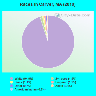
Races in Carver detailed stats: ancestries, foreign born residents, place of birth
According to our research of Massachusetts and other state lists, there were 6 registered sex offenders living in Carver, Massachusetts as of May 07, 2024.
The ratio of all residents to sex offenders in Carver is 1,918 to 1.
The ratio of registered sex offenders to all residents in this city is lower than the state average.
Type |
2009 |
2010 |
2011 |
2012 |
2013 |
2014 |
2015 |
2016 |
2017 |
2018 |
2019 |
2020 |
2021 |
2022 |
|---|---|---|---|---|---|---|---|---|---|---|---|---|---|---|
| Murders (per 100,000) | 0 (0.0) | 0 (0.0) | 0 (0.0) | 0 (0.0) | 0 (0.0) | 0 (0.0) | 0 (0.0) | 0 (0.0) | 0 (0.0) | 0 (0.0) | 0 (0.0) | 0 (0.0) | 0 (0.0) | 0 (0.0) |
| Rapes (per 100,000) | 4 (34.2) | 3 (26.1) | 2 (17.3) | 2 (17.1) | 6 (51.9) | 4 (34.7) | 3 (25.9) | 3 (25.9) | 5 (42.8) | 8 (68.1) | 6 (51.2) | 2 (16.4) | 3 (24.3) | 2 (16.4) |
| Robberies (per 100,000) | 3 (25.7) | 4 (34.8) | 2 (17.3) | 2 (17.1) | 1 (8.7) | 4 (34.7) | 1 (8.6) | 2 (17.2) | 1 (8.6) | 2 (17.0) | 3 (25.6) | 2 (16.4) | 0 (0.0) | 1 (8.2) |
| Assaults (per 100,000) | 17 (145.4) | 17 (147.7) | 26 (224.5) | 23 (197.0) | 28 (242.4) | 20 (173.6) | 18 (155.1) | 23 (198.3) | 19 (162.8) | 20 (170.3) | 17 (145.0) | 10 (82.0) | 8 (64.8) | 15 (122.8) |
| Burglaries (per 100,000) | 51 (436.2) | 75 (651.7) | 95 (820.5) | 84 (719.4) | 56 (484.8) | 23 (199.6) | 17 (146.5) | 17 (146.6) | 26 (222.8) | 6 (51.1) | 13 (110.9) | 13 (106.6) | 9 (72.9) | 3 (24.6) |
| Thefts (per 100,000) | 58 (496.1) | 111 (964.5) | 166 (1,434) | 196 (1,679) | 123 (1,065) | 104 (902.7) | 72 (620.5) | 76 (655.2) | 86 (736.9) | 59 (502.4) | 49 (418.1) | 43 (352.5) | 51 (413.1) | 34 (278.3) |
| Auto thefts (per 100,000) | 13 (111.2) | 10 (86.9) | 10 (86.4) | 11 (94.2) | 6 (51.9) | 10 (86.8) | 6 (51.7) | 10 (86.2) | 2 (17.1) | 5 (42.6) | 6 (51.2) | 6 (49.2) | 3 (24.3) | 3 (24.6) |
| Arson (per 100,000) | 1 (8.6) | 2 (17.4) | 6 (51.8) | 2 (17.1) | 2 (17.3) | 0 (0.0) | 2 (17.2) | 1 (8.6) | 1 (8.6) | 0 (0.0) | 0 (0.0) | 1 (8.2) | 0 (0.0) | 3 (24.6) |
| City-Data.com crime index | 123.4 | 152.0 | 185.6 | 183.3 | 173.3 | 129.9 | 93.5 | 108.9 | 115.8 | 120.8 | 106.2 | 59.9 | 56.0 | 54.9 |
The City-Data.com crime index weighs serious crimes and violent crimes more heavily. Higher means more crime, U.S. average is 246.1. It adjusts for the number of visitors and daily workers commuting into cities.
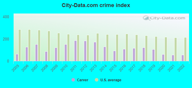
Crime rate in Carver detailed stats: murders, rapes, robberies, assaults, burglaries, thefts, arson
Full-time law enforcement employees in 2021, including police officers: 22 (17 officers - 16 male; 1 female).
| Officers per 1,000 residents here: | 1.38 |
| Massachusetts average: | 2.53 |
 Recent articles from our blog. Our writers, many of them Ph.D. graduates or candidates, create easy-to-read articles on a wide variety of topics.

 | 2023 Real Estate Observations (5278 replies) |
| Carver Girls’ Soccer Team With All-Star Boys’ Soccer Player Falls In State Semifinal (0 replies) |
| All-Star Boys’ Soccer Player Playing For Carver High Girls’ Team This Year (0 replies) |
| 2021 Real Estate Observations (1729 replies) |
| South Meadow Village Mobile Park Carver ma (4 replies) |
| Can the South Coast see massive Hispanic/black growth? (41 replies) |
Latest news from Carver, MA collected exclusively by city-data.com from local newspapers, TV, and radio stations
Carver, MA City Guides:
Ancestries: Irish (30.6%), Italian (21.2%), English (18.7%), French (9.3%), German (7.7%), Scottish (6.8%).
Current Local Time: EST time zone
Incorporated in 1790
Elevation: 92 feet
Land area: 37.5 square miles.
Population density: 307 people per square mile (very low).
324 residents are foreign born (1.1% North America, 1.0% Europe, 0.3% Africa, 0.3% Asia).
| This town: | 2.9% |
| Massachusetts: | 12.2% |
| Carver town: | 1.6% ($2,419) |
| Massachusetts: | 1.3% ($2,336) |
Nearest city with pop. 50,000+: Taunton, MA  (17.5 miles , pop. 55,976).
Nearest city with pop. 200,000+: Boston, MA (35.7 miles , pop. 589,141).
Nearest city with pop. 1,000,000+: Bronx, NY (176.5 miles , pop. 1,332,650).
Nearest cities:
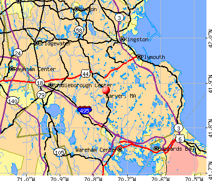
), ), ), )Latitude: 41.87 N, Longitude: 70.76 W
Area codes: 508, 774

Carver, Massachusetts accommodation & food services, waste management - Economy and Business Data
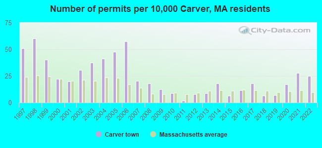
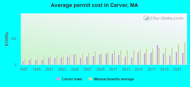
Single-family new house construction building permits:
- 2022: 28 buildings, average cost: $233,300
- 2021: 31 buildings, average cost: $247,600
- 2020: 19 buildings, average cost: $181,100
- 2019: 8 buildings, average cost: $219,700
- 2018: 7 buildings, average cost: $384,100
- 2017: 20 buildings, average cost: $236,700
- 2016: 13 buildings, average cost: $220,100
- 2015: 7 buildings, average cost: $243,000
- 2014: 20 buildings, average cost: $141,600
- 2013: 10 buildings, average cost: $163,000
- 2012: 9 buildings, average cost: $192,200
- 2011: 2 buildings, average cost: $219,500
- 2010: 10 buildings, average cost: $217,000
- 2009: 14 buildings, average cost: $198,900
- 2008: 20 buildings, average cost: $170,200
- 2007: 23 buildings, average cost: $164,200
- 2006: 64 buildings, average cost: $131,100
- 2005: 53 buildings, average cost: $202,700
- 2004: 46 buildings, average cost: $161,300
- 2003: 42 buildings, average cost: $141,700
- 2002: 34 buildings, average cost: $136,400
- 2001: 22 buildings, average cost: $135,600
- 2000: 25 buildings, average cost: $102,100
- 1999: 45 buildings, average cost: $91,800
- 1998: 67 buildings, average cost: $91,700
- 1997: 57 buildings, average cost: $78,900
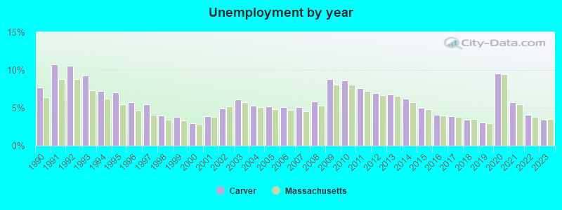
| Here: | 3.4% |
| Massachusetts: | 3.5% |
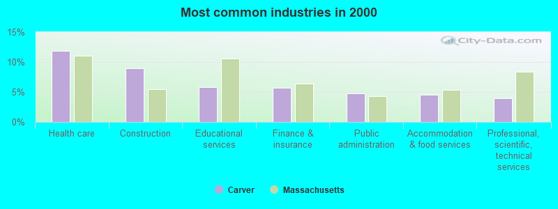
- Health care (11.8%)
- Construction (8.9%)
- Educational services (5.8%)
- Finance & insurance (5.7%)
- Public administration (4.7%)
- Accommodation & food services (4.6%)
- Professional, scientific, technical services (4.0%)
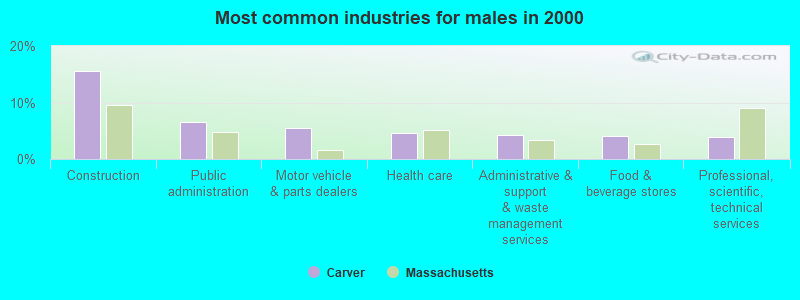
- Construction (15.6%)
- Public administration (6.6%)
- Motor vehicle & parts dealers (5.5%)
- Health care (4.6%)
- Administrative & support & waste management services (4.3%)
- Food & beverage stores (4.1%)
- Professional, scientific, technical services (3.9%)
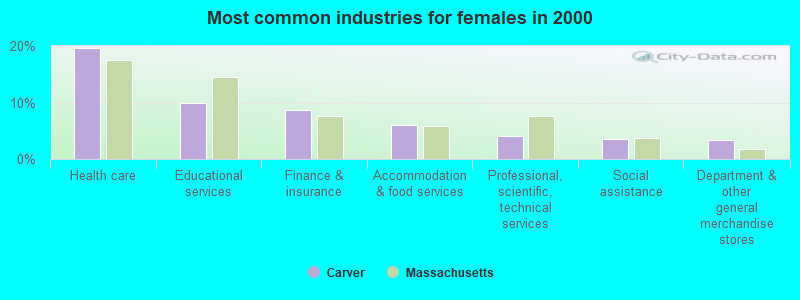
- Health care (19.7%)
- Educational services (9.9%)
- Finance & insurance (8.6%)
- Accommodation & food services (6.0%)
- Professional, scientific, technical services (4.1%)
- Social assistance (3.6%)
- Department & other general merchandise stores (3.4%)
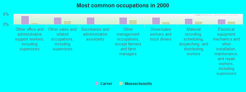
- Other office and administrative support workers, including supervisors (5.1%)
- Other sales and related occupations, including supervisors (4.3%)
- Secretaries and administrative assistants (4.2%)
- Other management occupations, except farmers and farm managers (4.1%)
- Driver/sales workers and truck drivers (4.1%)
- Material recording, scheduling, dispatching, and distributing workers (3.4%)
- Electrical equipment mechanics and other installation, maintenance, and repair workers, including supervisors (3.1%)
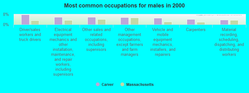
- Driver/sales workers and truck drivers (7.9%)
- Electrical equipment mechanics and other installation, maintenance, and repair workers, including supervisors (5.9%)
- Other sales and related occupations, including supervisors (5.7%)
- Other management occupations, except farmers and farm managers (5.6%)
- Vehicle and mobile equipment mechanics, installers, and repairers (5.1%)
- Carpenters (4.1%)
- Material recording, scheduling, dispatching, and distributing workers (3.5%)
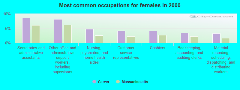
- Secretaries and administrative assistants (8.6%)
- Other office and administrative support workers, including supervisors (8.1%)
- Nursing, psychiatric, and home health aides (4.7%)
- Customer service representatives (4.2%)
- Cashiers (4.1%)
- Bookkeeping, accounting, and auditing clerks (3.5%)
- Material recording, scheduling, dispatching, and distributing workers (3.3%)
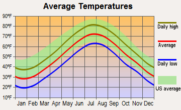
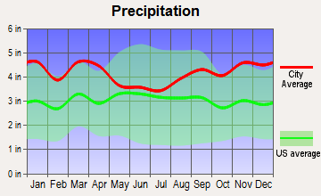
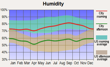
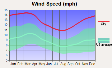
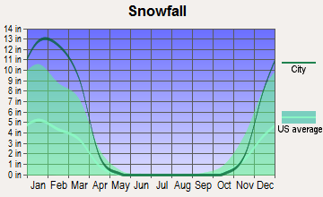
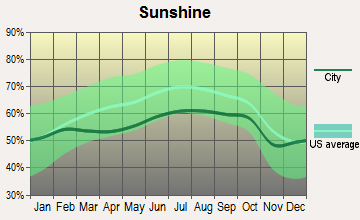
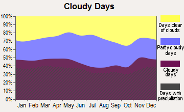
Average climate in Carver, Massachusetts
Based on data reported by over 4,000 weather stations
(lower is better)
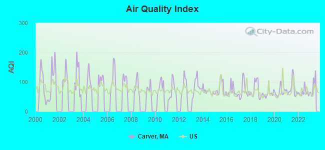
Air Quality Index (AQI) level in 2022 was 64.1. This is about average.
| City: | 64.1 |
| U.S.: | 72.6 |
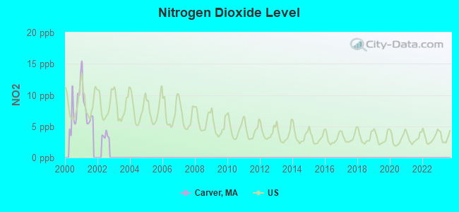
Nitrogen Dioxide (NO2) [ppb] level in 2001 was 7.90. This is significantly worse than average. Closest monitor was 7.7 miles away from the city center.
| City: | 7.90 |
| U.S.: | 5.11 |
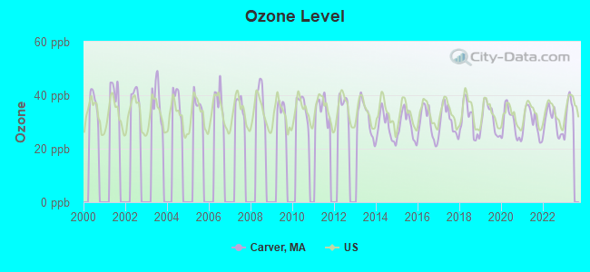
Ozone [ppb] level in 2022 was 30.0. This is about average. Closest monitor was 17.1 miles away from the city center.
| City: | 30.0 |
| U.S.: | 33.3 |
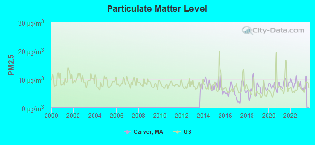
Particulate Matter (PM2.5) [µg/m3] level in 2022 was 8.70. This is about average. Closest monitor was 18.8 miles away from the city center.
| City: | 8.70 |
| U.S.: | 8.11 |
Tornado activity:
Carver-area historical tornado activity is below Massachusetts state average. It is 70% smaller than the overall U.S. average.
On 6/9/1953, a category F3 (max. wind speeds 158-206 mph) tornado 26.0 miles away from the Carver town center injured 17 people and caused between $500,000 and $5,000,000 in damages.
On 6/9/1953, a category F4 (max. wind speeds 207-260 mph) tornado 49.2 miles away from the town center killed 90 people and injured 1228 people and caused between $50,000,000 and $500,000,000 in damages.
Earthquake activity:
Carver-area historical earthquake activity is significantly above Massachusetts state average. It is 75% smaller than the overall U.S. average.On 10/7/1983 at 10:18:46, a magnitude 5.3 (5.1 MB, 5.3 LG, 5.1 ML, Class: Moderate, Intensity: VI - VII) earthquake occurred 231.8 miles away from Carver center
On 4/20/2002 at 10:50:47, a magnitude 5.3 (5.3 ML, Depth: 3.0 mi) earthquake occurred 235.4 miles away from Carver center
On 10/16/2012 at 23:12:25, a magnitude 4.7 (4.7 ML, Depth: 10.0 mi, Class: Light, Intensity: IV - V) earthquake occurred 119.7 miles away from Carver center
On 1/19/1982 at 00:14:42, a magnitude 4.7 (4.5 MB, 4.7 MD, 4.5 LG) earthquake occurred 120.7 miles away from the city center
On 4/20/2002 at 10:50:47, a magnitude 5.2 (5.2 MB, 4.2 MS, 5.2 MW, 5.0 MW) earthquake occurred 234.7 miles away from the city center
On 8/22/1992 at 12:20:32, a magnitude 4.8 (4.8 MB, 3.8 MS, 4.7 LG, Depth: 6.2 mi) earthquake occurred 192.5 miles away from the city center
Magnitude types: regional Lg-wave magnitude (LG), body-wave magnitude (MB), duration magnitude (MD), local magnitude (ML), surface-wave magnitude (MS), moment magnitude (MW)
Natural disasters:
The number of natural disasters in Plymouth County (26) is a lot greater than the US average (15).Major Disasters (Presidential) Declared: 17
Emergencies Declared: 9
Causes of natural disasters: Floods: 11, Storms: 9, Hurricanes: 7, Snows: 3, Snowstorms: 3, Blizzards: 2, Winter Storms: 2, Heavy Rain: 1, Snowfall: 1, Tropical Storm: 1, Wind: 1 (Note: some incidents may be assigned to more than one category).
Hospitals and medical centers near Carver:
- HANNAH B G SHAW HOME FOR THE AGED (Nursing Home, about 7 miles away; MIDDLEBORO, MA)
- NEMASKET HEALTHCARE CENTER (Nursing Home, about 7 miles away; MIDDLEBOROUGH, MA)
- LIFE CARE CENTER OF PLYMOUTH (Nursing Home, about 8 miles away; PLYMOUTH, MA)
- TREMONT HEALTH CARE CENTER (Nursing Home, about 8 miles away; WAREHAM, MA)
- HOSPICE SERVICES OF MASSACHUSETTS (Hospital, about 8 miles away; WAREHAM, MA)
- PILGRIM MANOR NURSING HOME (Nursing Home, about 8 miles away; PLYMOUTH, MA)
- PILGRIM MANOR SKILD NURS AND REH (Nursing Home, about 8 miles away; PLYMOUTH, MA)
Heliports located in Carver:
See details about Heliports located in Carver, MAOperable nuclear power plant near Carver:
- 8 miles: Pilgrim in Plymouth, MA.
Colleges/universities with over 2000 students nearest to Carver:
- Bridgewater State University (about 14 miles; Bridgewater, MA; Full-time enrollment: 9,802)
- Massasoit Community College (about 19 miles; Brockton, MA; FT enrollment: 5,442)
- University of Massachusetts-Dartmouth (about 21 miles; North Dartmouth, MA; FT enrollment: 7,545)
- Stonehill College (about 22 miles; Easton, MA; FT enrollment: 2,563)
- Bristol Community College (about 22 miles; Fall River, MA; FT enrollment: 5,707)
- Cape Cod Community College (about 25 miles; West Barnstable, MA; FT enrollment: 2,491)
- Quincy College (about 30 miles; Quincy, MA; FT enrollment: 3,184)
Public high school in Carver:
Public elementary/middle school in Carver:
- CARVER ELEMENTARY SCHOOL (Students: 492, Location: 85 MAIN STREET, Grades: PK-5)
Library in Carver:
- CARVER PUBLIC LIBRARY (Operating income: $372,269; Location: 2 MEADOWBROOK WAY; 53,843 books; 211 e-books; 3,002 audio materials; 2,264 video materials; 3 local licensed databases; 34 state licensed databases; 1 other licensed databases; 93 print serial subscriptions; 2 electronic serial subscriptions)
Points of interest:
Notable locations in Carver: Carver Emergency Medical Services Station (A), Carver Fire Department Station 2 (B), Carver Fire Department Station 3 (C), Carver High School Library (D), Carver Fire Department Station 1 (E), Carver Town Hall (F). Display/hide their locations on the map
Shopping Centers: Carver Square Shopping Center (1), Silo Marketplace Shopping Center (2). Display/hide their locations on the map
Churches in Carver include: United Parish of Carver (A), Our Lady of Lourdes Church (B), Open Door Church of God (C), Mount Carmel Baptist Church (D), Faith Baptist Church of Plymouth (E), Faith Baptist Church (F), Cranberry Chapel Assembly of God Church (G). Display/hide their locations on the map
Cemeteries: Lakenham Cemetery (1), Center Cemetery (2), Central Cemetery (3), Union Cemetery (4), Wenham Cemetery (5). Display/hide their locations on the map
Lakes, reservoirs, and swamps: Raccoon Pond (A), Pratt Pond (B), Grady Pond (C), Dunham Pond (D), Bates Pond (E), Clear Pond (F), Barret Pond (G), Clear Bottom Pond (H). Display/hide their locations on the map
Streams, rivers, and creeks: Hunting House Brook (A), Indian Brook (B), Rocky Meadow Brook (C), Sampson Brook (D), South Meadow Brook (E), Tilson Brook (F), Muddy Pond Brook (G), Herring Brook (H), Horse Neck Brook (I). Display/hide their locations on the map
Parks in Carver include: Savery Historic District (1), Lakenham Historic District (2), Shurtleff Park (3). Display/hide their locations on the map
Birthplace of: Mike Bennett (wrestler) - Professional wrestler.
Drinking water stations with addresses in Carver and their reported violations in the past:
SOUTH MEADOW VILLAGE (Population served: 700, Groundwater):Past health violations:CRANBERRY VILLAGE INC (Population served: 414, Purch groundwater):Past monitoring violations:
- MCL, Monthly (TCR) - In NOV-2012, Contaminant: Coliform. Follow-up actions: St AO (w/o penalty) issued (FEB-27-2013), St Compliance achieved (FEB-27-2013)
- Follow-up Or Routine LCR Tap M/R - In OCT-01-2007, Contaminant: Lead and Copper Rule. Follow-up actions: St AO (w/o penalty) issued (NOV-14-2007), St Compliance achieved (NOV-14-2008)
- 24 regular monitoring violations
Past health violations:TOWN OF CARVER (Address: 108 MAIN STREET , Population served: 414, Groundwater):Past monitoring violations:
- MCL, Monthly (TCR) - In OCT-2005, Contaminant: Coliform. Follow-up actions: St AO (w/o penalty) issued (MAY-18-2006), St Compliance achieved (MAY-18-2006)
- 2 minor monitoring violations
Past health violations:PINETREE VILLAGE (Population served: 348, Groundwater):Past monitoring violations:
- MCL, Monthly (TCR) - In AUG-2013, Contaminant: Coliform. Follow-up actions: St AO (w/o penalty) issued (NOV-29-2013), St Compliance achieved (NOV-29-2013)
- One routine major monitoring violation
Past monitoring violations:MEADOW WOODS MOBILE HOME PARK (Population served: 120, Groundwater):
- One regular monitoring violation
Past monitoring violations:CARVER MUNICIPAL BUILDINGS (Population served: 100, Groundwater):
- Follow-up Or Routine LCR Tap M/R - In OCT-01-2007, Contaminant: Lead and Copper Rule. Follow-up actions: St AO (w/o penalty) issued (NOV-14-2007), St Compliance achieved (MAR-06-2008)
- 2 regular monitoring violations
Past health violations:NORTH CARVER WATER DISTRICT (Address: 108 MAIN STREET , Population served: 100, Groundwater):Past monitoring violations:
- MCL, Monthly (TCR) - In OCT-2012, Contaminant: Coliform. Follow-up actions: St AO (w/o penalty) issued (FEB-21-2013), St Compliance achieved (FEB-21-2013)
- Follow-up Or Routine LCR Tap M/R - In OCT-01-2012, Contaminant: Lead and Copper Rule. Follow-up actions: St AO (w/o penalty) issued (OCT-25-2012), St Compliance achieved (DEC-03-2013)
- Follow-up Or Routine LCR Tap M/R - In OCT-01-2008, Contaminant: Lead and Copper Rule. Follow-up actions: St AO (w/o penalty) issued (NOV-12-2008), St Compliance achieved (SEP-04-2009)
- One routine major monitoring violation
- One regular monitoring violation
Past health violations:Past monitoring violations:
- MCL, Monthly (TCR) - In JAN-2013, Contaminant: Coliform. Follow-up actions: St AO (w/o penalty) issued (MAY-30-2013), St Compliance achieved (MAY-30-2013)
- MCL, Monthly (TCR) - In AUG-2012, Contaminant: Coliform. Follow-up actions: St AO (w/o penalty) issued (NOV-30-2012), St Compliance achieved (JAN-17-2013)
- MCL, Monthly (TCR) - In MAY-2012, Contaminant: Coliform. Follow-up actions: St AO (w/o penalty) issued (AUG-31-2012), St Compliance achieved (AUG-31-2012)
- MCL, Monthly (TCR) - In SEP-2011, Contaminant: Coliform. Follow-up actions: St AO (w/o penalty) issued (NOV-29-2011), St Compliance achieved (NOV-29-2011)
- Water Quality Parameter M/R - In JAN-01-2011, Contaminant: Lead and Copper Rule. Follow-up actions: St AO (w/o penalty) issued (AUG-23-2011), St Compliance achieved (JAN-03-2012)
Drinking water stations with addresses in Carver that have no violations reported:
- TOWNHOUSES AT CHANCE COURT (Population served: 40, Primary Water Source Type: Groundwater)
| This town: | 2.7 people |
| Massachusetts: | 2.5 people |
| This town: | 72.9% |
| Whole state: | 63.0% |
| This town: | 6.6% |
| Whole state: | 7.0% |
Likely homosexual households (counted as self-reported same-sex unmarried-partner households)
- Lesbian couples: 0.5% of all households
- Gay men: 0.3% of all households
| This town: | 5.0% |
| Whole state: | 9.3% |
| This town: | 2.5% |
| Whole state: | 4.4% |
7 people in homes for the mentally ill in 2000
4 people in homes for the mentally retarded in 2000
Banks with branches in Carver (2011 data):
- Mutual Federal Savings Bank of Plymouth County: Main St Street Branch at 74 Main Street, branch established on 1889/01/01. Info updated 2011/07/21: Bank assets: $369.9 mil, Deposits: $260.8 mil, headquarters in Whitman, MA, positive income, Mortgage Lending Specialization, 9 total offices
- Bridgewater Savings Bank: Carver Branch at 100 Main Street, branch established on 1992/11/12. Info updated 2010/02/03: Bank assets: $491.1 mil, Deposits: $376.9 mil, headquarters in Raynham, MA, positive income, Commercial Lending Specialization, 10 total offices, Holding Company: Bridgewater Financial, Mhc
- Rockland Trust Company: Carver Square Branch at 124 Main St, branch established on 1987/05/11. Info updated 2009/05/20: Bank assets: $4,974.4 mil, Deposits: $3,903.9 mil, headquarters in Rockland, MA, positive income, Commercial Lending Specialization, 67 total offices, Holding Company: Independent Bank Corp.
For population 15 years and over in Carver:
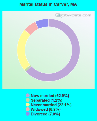
- Never married: 22.1%
- Now married: 62.9%
- Separated: 1.2%
- Widowed: 6.8%
- Divorced: 7.0%
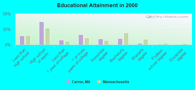
For population 25 years and over in Carver:
- High school or higher: 85.5%
- Bachelor's degree or higher: 13.8%
- Graduate or professional degree: 3.5%
- Unemployed: 3.1%
- Mean travel time to work (commute): 35.7 minutes
| Here: | 8.6 |
| Massachusetts average: | 13.1 |


Graphs represent county-level data. Detailed 2008 Election Results
Religion statistics for Carver, MA (based on Plymouth County data)


| Religion | Adherents | Congregations |
|---|---|---|
| Catholic | 165,985 | 35 |
| Mainline Protestant | 23,724 | 91 |
| Evangelical Protestant | 13,159 | 96 |
| Other | 6,129 | 43 |
| Orthodox | 1,140 | 3 |
| Black Protestant | 611 | 5 |
| None | 284,171 | - |
Food Environment Statistics:
| Plymouth County: | 1.74 / 10,000 pop. |
| State: | 1.98 / 10,000 pop. |
| Plymouth County: | 0.04 / 10,000 pop. |
| State: | 0.05 / 10,000 pop. |
| This county: | 2.84 / 10,000 pop. |
| Massachusetts: | 2.22 / 10,000 pop. |
| Plymouth County: | 2.20 / 10,000 pop. |
| Massachusetts: | 1.77 / 10,000 pop. |
| Plymouth County: | 7.37 / 10,000 pop. |
| State: | 8.76 / 10,000 pop. |
| Plymouth County: | 7.9% |
| Massachusetts: | 8.1% |
| Plymouth County: | 21.7% |
| State: | 22.5% |
| Plymouth County: | 16.3% |
| Massachusetts: | 16.5% |
5.54% of this county's 2020 resident taxpayers moved to other counties in 2021 ($85,482 average adjusted gross income)
| Here: | 5.54% |
| Massachusetts average: | 7.18% |
0.01% of residents moved to foreign countries ($80 average AGI)
Plymouth County: 0.01% Massachusetts average: 0.02%
Top counties to which taxpayers relocated from this county between 2020 and 2021:
| to Bristol County, MA | |
| to Norfolk County, MA | |
| to Suffolk County, MA |
| Businesses in Carver, MA | ||||
| Name | Count | Name | Count | |
|---|---|---|---|---|
| CVS | 1 | U-Haul | 1 | |
| Dunkin Donuts | 2 | UPS | 1 | |
| Shaw's | 1 | |||
Strongest AM radio stations in Carver:
- WPLM (1390 AM; 5 kW; PLYMOUTH, MA; Owner: PLYMOUTH ROCK BROADCASTING CO., INC.)
- WBZ (1030 AM; 50 kW; BOSTON, MA; Owner: INFINITY BROADCASTING OPERATIONS, INC.)
- WEEI (850 AM; 50 kW; BOSTON, MA; Owner: ENTERCOM BOSTON LICENSE, LLC)
- WRKO (680 AM; 50 kW; BOSTON, MA; Owner: ENTERCOM BOSTON LICENSE, LLC)
- WALE (990 AM; 50 kW; GREENVILLE, RI; Owner: NORTH AMERICAN BROADCASTING CO., INC.)
- WKOX (1200 AM; 50 kW; FRAMINGHAM, MA; Owner: CAPSTAR TX LIMITED PARTNERSHIP)
- WWZN (1510 AM; 50 kW; BOSTON, MA; Owner: ROSE CITY RADIO CORPORATION)
- WBIX (1060 AM; 40 kW; NATICK, MA; Owner: LANGER BROADCASTING CORPORATION)
- WAMG (890 AM; 25 kW; DEDHAM, MA; Owner: MEGA COMMUNICATIONS OF DEDHAM LICENSEE, LLC)
- WCRN (830 AM; 50 kW; WORCESTER, MA; Owner: CARTER BROADCASTING CORPORATION)
- WBSM (1420 AM; 5 kW; NEW BEDFORD, MA; Owner: CITADEL BROADCASTING COMPANY)
- WRCA (1330 AM; 25 kW; WALTHAM, MA; Owner: WRCA LICENSE, LLC)
- WUNR (1600 AM; 20 kW; BROOKLINE, MA; Owner: CHAMPION BROADCASTING SYSTEMS, INC.)
Strongest FM radio stations in Carver:
- WPLM-FM (99.1 FM; PLYMOUTH, MA; Owner: PLYMOUTH ROCK BROADCASTING CO., INC.)
- WJFD-FM (97.3 FM; NEW BEDFORD, MA; Owner: EDMUND DINIS, TRUSTEE)
- WWBB (101.5 FM; PROVIDENCE, RI; Owner: CLEAR CHANNEL BROADCASTING LICENSES, INC.)
- WATD-FM (95.9 FM; MARSHFIELD, MA; Owner: MARSHFIELD BROADCASTING CO., INC.)
- WCTK (98.1 FM; NEW BEDFORD, MA; Owner: HALL COMMUNICATIONS, INC.)
- WXKS-FM (107.9 FM; MEDFORD, MA; Owner: AMFM RADIO LICENSES, L.L.C.)
- WMJX (106.7 FM; BOSTON, MA; Owner: GREATER BOSTON RADIO, INC.)
- WBOT (97.7 FM; BROCKTON, MA; Owner: RADIO ONE LICENSES, LLC)
- WBMX (98.5 FM; BOSTON, MA; Owner: INFINITY RADIO OPERATIONS INC.)
- WBOS (92.9 FM; BROOKLINE, MA; Owner: GREATER BOSTON RADIO, INC.)
- WJMN (94.5 FM; BOSTON, MA; Owner: AMFM RADIO LICENSES, L.L.C.)
- WCRB (102.5 FM; WALTHAM, MA; Owner: CHARLES RIVER BROADCASTING WCRB LICE)
- WTKK (96.9 FM; BOSTON, MA; Owner: GREATER BOSTON RADIO, INC.)
- WROR-FM (105.7 FM; FRAMINGHAM, MA; Owner: GREATER BOSTON RADIO, INC.)
- WGBH (89.7 FM; BOSTON, MA; Owner: WGBH EDUCATIONAL FOUNDATION)
- WBUR-FM (90.9 FM; BOSTON, MA; Owner: TRUSTEES OF BOSTON UNIVERSITY)
- WSNE-FM (93.3 FM; TAUNTON, MA; Owner: CAPSTAR TX LIMITED PARTNERSHIP)
- WFHN (107.1 FM; FAIRHAVEN, MA; Owner: CITADEL BROADCASTING COMPANY)
- WCIB (101.9 FM; FALMOUTH, MA; Owner: QANTUM OF CAPE COD LICENSE COMPANY, LLC)
- WODS (103.3 FM; BOSTON, MA; Owner: INFINITY BROADCASTING OPERATIONS, INC.)
TV broadcast stations around Carver:
- WLWC (Channel 28; NEW BEDFORD, MA; Owner: C-28 FCC LICENSEE SUBSIDIARY, LLC)
- WWDP (Channel 46; NORWELL, MA; Owner: NORWELL TELEVISION, LLC)
- WLNE-TV (Channel 6; NEW BEDFORD, MA; Owner: FREEDOM BROADCASTING OF SOUTHERN NEW ENGLAND, INC.)
- WCVB-TV (Channel 5; BOSTON, MA; Owner: WCVB HEARST-ARGYLE TV, INC.)
- WGBH-TV (Channel 2; BOSTON, MA; Owner: WGBH EDUCATIONAL FOUNDATION)
- WPRI-TV (Channel 12; PROVIDENCE, RI; Owner: TVL BROADCASTING OF RHODE ISLAND, LLC)
- WNAC-TV (Channel 64; PROVIDENCE, RI; Owner: WNAC, LLC)
- WJAR (Channel 10; PROVIDENCE, RI; Owner: OUTLET BROADCASTING, INC.)
- WHDH-TV (Channel 7; BOSTON, MA; Owner: WHDH-TV)
- WMFP (Channel 62; LAWRENCE, MA; Owner: WSAH LICENSE, INC.)
- WSBK-TV (Channel 38; BOSTON, MA; Owner: VIACOM INC.)
- WLVI-TV (Channel 56; CAMBRIDGE, MA; Owner: WLVI, INC.)
- WBZ-TV (Channel 4; BOSTON, MA; Owner: VIACOM INC.)
- WGBX-TV (Channel 44; BOSTON, MA; Owner: WGBH EDUCATIONAL FOUNDATION)
- WSBE-TV (Channel 36; PROVIDENCE, RI; Owner: RHODE ISLAND PUBLIC TELECOM. AUTHORITY)
- WFXT (Channel 25; BOSTON, MA; Owner: FOX TELEVISION STATIONS INC.)
- WBPX (Channel 68; BOSTON, MA; Owner: PAXSON BOSTON-68 LICENSE, INC.)
- WTMU-LP (Channel 32; BOSTON, MA; Owner: ZGS BOSTON, INC.)
- W40BO (Channel 40; BOSTON, MA; Owner: PAXSON COMMUNICATIONS LPTV, INC.)
- WCEA-LP (Channel 58; BOSTON, MA; Owner: CHANNEL 19 TV CORPORATION)
- WDPX (Channel 58; VINEYARD HAVEN, MA; Owner: PAXSON BOSTON-68 LICENSE, INC.)
- WMPX-LP (Channel 67; DENNIS, MA; Owner: PAXSON BOSTON-68 LICENSE, INC.)
Medal of Honor Recipients
Medal of Honor Recipient born in Carver: Lowell M. Maxham.
- National Bridge Inventory (NBI) Statistics
- 6Number of bridges
- 85ft / 25.6mTotal length
- $3,381,000Total costs
- 119,306Total average daily traffic
- 12,775Total average daily truck traffic
- 174,670Total future (year 2032) average daily traffic
FCC Registered Antenna Towers:
33 (See the full list of FCC Registered Antenna Towers in Carver)FCC Registered Broadcast Land Mobile Towers:
8 (See the full list of FCC Registered Broadcast Land Mobile Towers in Carver, MA)FCC Registered Microwave Towers:
1- BS23XC471, 391 Shoestring Road (Lat: 41.860528 Lon: -70.726556), Type: Tower, Structure height: 45.7 m, Overall height: 48.7 m, Call Sign: WQPU675,
Assigned Frequencies: 10815.0 MHz, 10815.0 MHz, 10815.0 MHz, Grant Date: 08/20/2012, Expiration Date: 08/20/2022, Cancellation Date: 08/10/2022, Certifier: David Werblow, Registrant: Dla Piper LLP, 500 8th Street, Nw, Washington, DC 20004, Phone: (202) 799-4216, Fax: (202) 799-5616, Email:
FCC Registered Amateur Radio Licenses:
53 (See the full list of FCC Registered Amateur Radio Licenses in Carver)FAA Registered Aircraft Manufacturers and Dealers:
1- B & A HELICOPTER SERVICES INC, Po Box 590, Carver, MA 02330
Certificate: 03-0188 (Corporation), Certificate Issue Date: 01/29/2003, Expiration Date: 01/28/2004
FAA Registered Aircraft:
4- Aircraft: MOONEY AIRCRAFT CORP. M20K (Category: Land, Seats: 4, Weight: Up to 12,499 Pounds), Engine: CONT MOTOR TSIO-360 SER (225 HP) (Reciprocating)
N-Number: 231HE, N231HE, N-231HE, Serial Number: 25-0257, Year manufactured: 1979, Airworthiness Date: 11/26/1979, Certificate Issue Date: 01/15/2020
Registrant (Individual): Peter S Singer, 72 S Meadow Rd, Carver, MA 02330 - Aircraft: CESSNA 210L (Category: Land, Seats: 6, Weight: Up to 12,499 Pounds, Speed: 87 mph), Engine: CONT MOTOR IO 520 SERIES (285 HP) (Reciprocating)
N-Number: 2476S, N2476S, N-2476S, Serial Number: 21061297, Year manufactured: 1976, Airworthiness Date: 04/21/1976, Certificate Issue Date: 12/05/2002
Registrant (Individual): Robert E Bentley, 60 Wenham Rd, Carver, MA 02330 - Aircraft: PIPER PA-32-300 (Category: Land, Seats: 6, Weight: Up to 12,499 Pounds, Speed: 126 mph), Engine: LYCOMING TI0-540 SER (310 HP) (Reciprocating)
N-Number: 3338Q, N3338Q, N-3338Q, Serial Number: 32-7740062, Airworthiness Date: 04/11/1977, Certificate Issue Date: 06/10/2020
Registrant (Individual): Danny R Warren, Po Box 1206, Carver, MA 02330 - Aircraft: DJI PHANTOM 3 PROFESSION (Category: Land, Engines: 4), Engine: Electric
N-Number: 333TK, N333TK, N-333TK, Serial Number: P76DCF04013938, Certificate Issue Date: 09/18/2015
Registrant (Individual): Peter J Brown, 67 Fosdick Rd, Carver, MA 02330
Deregistered: Cancel Date: 04/04/1995
2002 - 2018 National Fire Incident Reporting System (NFIRS) incidents
- Fire incident types reported to NFIRS in Carver, MA
- 8458.3%Structure Fires
- 5538.2%Mobile Property/Vehicle Fires
- 42.8%Outside Fires
- 10.7%Other
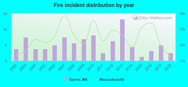 According to the data from the years 2002 - 2018 the average number of fire incidents per year is 8. The highest number of fire incidents - 21 took place in 2013, and the least - 2 in 2015. The data has a declining trend.
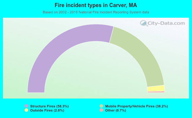 When looking into fire subcategories, the most incidents belonged to: Structure Fires (58.3%), and Mobile Property/Vehicle Fires (38.2%).
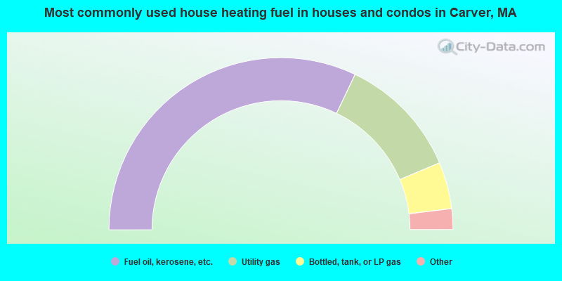
- 64.2%Fuel oil, kerosene, etc.
- 23.1%Utility gas
- 8.8%Bottled, tank, or LP gas
- 2.3%Electricity
- 1.5%Wood
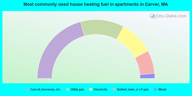
- 41.5%Fuel oil, kerosene, etc.
- 24.0%Utility gas
- 19.0%Electricity
- 12.8%Bottled, tank, or LP gas
- 2.7%Wood
Carver compared to Massachusetts state average:
- Unemployed percentage significantly below state average.
- Black race population percentage significantly below state average.
- Hispanic race population percentage significantly below state average.
- Foreign-born population percentage significantly below state average.
- Renting percentage significantly below state average.
- Length of stay since moving in significantly above state average.
- Number of rooms per house significantly below state average.
- House age significantly below state average.
- Number of college students below state average.
- Percentage of population with a bachelor's degree or higher significantly below state average.
Carver on our top lists:
- #10 on the list of "Top 101 cities with largest percentage of males in occupations: occupational and physical therapist assistants and aides (population 5,000+)"
- #10 on the list of "Top 101 cities with largest percentage of males in industries: music stores (population 5,000+)"
- #16 on the list of "Top 101 cities with largest percentage of males in industries: motor vehicle and parts dealers (population 5,000+)"
- #28 on the list of "Top 101 cities with largest percentage of males in occupations: printing workers (population 5,000+)"
- #28 on the list of "Top 101 cities with largest percentage of females in industries: recyclable material merchant wholesalers (population 5,000+)"
- #33 on the list of "Top 101 cities with largest percentage of males in industries: clothing and accessories, including shoe, stores (population 5,000+)"
- #33 on the list of "Top 101 cities with largest percentage of females in industries: rail transportation (population 5,000+)"
- #41 on the list of "Top 101 cities with largest percentage of females in occupations: vehicle and mobile equipment mechanics, installers, and repairers (population 5,000+)"
- #42 on the list of "Top 101 cities with largest percentage of males in industries: alcoholic beverages merchant wholesalers (population 5,000+)"
- #45 on the list of "Top 100 low-educated but high-earning cities (pop. 5,000+)"
- #46 on the list of "Top 101 cities with largest percentage of males in industries: retail florists (population 5,000+)"
- #65 on the list of "Top 101 cities with largest percentage of females in industries: electronic shopping and mail-order houses (population 5,000+)"
- #75 on the list of "Top 101 cities with largest percentage of males in industries: printing and related support activities (population 5,000+)"
- #79 on the list of "Top 101 cities with largest percentage of females in occupations: customer service representatives (population 5,000+)"
- #88 on the list of "Top 101 cities with largest percentage of females in industries: pharmacies and drug stores (population 5,000+)"
- #92 on the list of "Top 101 cities with largest percentage of males in industries: food and beverage stores (population 5,000+)"
- #99 on the list of "Top 101 cities with largest percentage of females in occupations: nursing, psychiatric, and home health aides (population 5,000+)"
- #99 on the list of "Top 101 cities with largest percentage of males in occupations: registered nurses (population 5,000+)"
- #18 on the list of "Top 101 counties with the highest percentage of residents that visited a dentist within the past year"
- #24 on the list of "Top 101 counties with the highest percentage of residents that smoked 100+ cigarettes in their lives"
- #35 on the list of "Top 101 counties with the largest decrease in the number of births per 1000 residents 2000-2006 to 2007-2013 (pop 50,000+)"
- #39 on the list of "Top 101 counties with the lowest percentage of residents that keep firearms around their homes"
- #39 on the list of "Top 101 counties with the lowest number of infant deaths per 1000 residents 2007-2013 (pop. 50,000+)"

|
|
Total of 34 patent applications in 2008-2024.