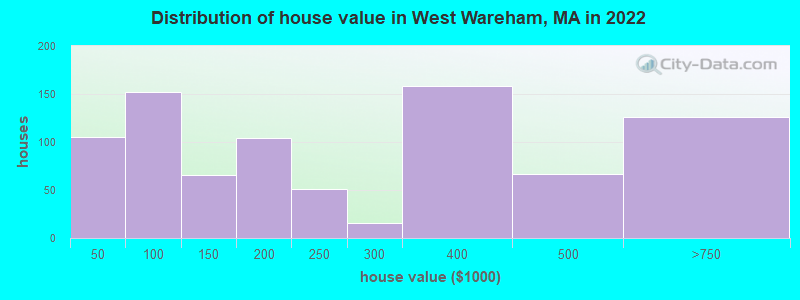
Estimated median house or condo value in 2022: $247,576 (it was $95,300 in 2000)
West Wareham:
$247,576
MA:
$534,700
Mean prices in 2022:all housing units: $585,203; detached houses: $620,100; townhouses or other attached units: $487,972; in 2-unit structures: $464,355; in 3-to-4-unit structures: $429,583; in 5-or-more-unit structures: $438,441; mobile homes: $207,706; occupied boats, rvs, vans, etc.: $17,153
Median gross rent in 2022: $1,336.
March 2022 cost of living index in West Wareham: 132.7 (high, U.S. average is 100)
Latest news from West Wareham, MA collected exclusively by city-data.com from local newspapers, TV, and radio stations
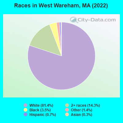
Ancestries: English (22.0%), American (15.5%), French (13.8%), Cape Verdean (8.3%), Portuguese (7.9%), Scotch-Irish (5.0%).
Current Local Time: EST time zone
Elevation: 40 feet
Land area: 3.72 square miles.
Population density: 555 people per square mile (low).
83 residents are foreign born (2.8% Europe).
This place:
3.2%
Massachusetts:
17.6%
Median real estate property taxes paid for housing units with mortgages in 2022: $4,481 (1.0%) Median real estate property taxes paid for housing units with no mortgage in 2022: $2,922 (1.5%)
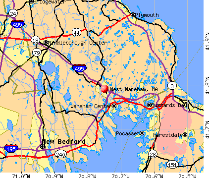
Nearest city with pop. 50,000+: New Bedford, MA (13.5 miles , pop. 93,768).
Nearest city with pop. 200,000+: Boston, MA (40.6 miles , pop. 589,141).
Nearest city with pop. 1,000,000+: Bronx, NY (174.9 miles , pop. 1,332,650).
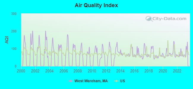
Air Quality Index (AQI) level in 2022 was 64.1. This is about average.
City:
64.1
U.S.:
72.6
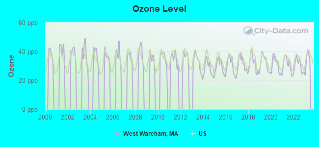
Ozone [ppb] level in 2022 was 30.3. This is about average.Closest monitor was 12.6 miles away from the city center.
City:
30.3
U.S.:
33.3
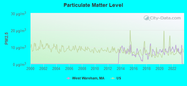
Particulate Matter (PM2.5) [µg/m3] level in 2022 was 8.70. This is about average.Closest monitor was 14.4 miles away from the city center.
City:
8.70
U.S.:
8.11
Tornado activity:
West Wareham-area historical tornado activity is significantly below Massachusetts state average. It is 73% smaller than the overall U.S. average.
On 6/9/1953, a category F3 (max. wind speeds 158-206 mph) tornado 29.3 miles away from the West Wareham place center injured 17 peopleand causedbetween $500,000 and $5,000,000 in damages.
On 6/9/1953, a category F4 (max. wind speeds 207-260 mph) tornado 52.9 miles away from the place center killed 90 peopleand injured 1228 peopleand causedbetween $50,000,000 and $500,000,000 in damages.
Earthquake activity:
West Wareham-area historical earthquake activity is significantly above Massachusetts state average. It is 75% smaller than the overall U.S. average.
On 10/7/1983 at 10:18:46, a magnitude 5.3 (5.1 MB, 5.3 LG, 5.1 ML, Class: Moderate, Intensity: VI - VII) earthquake occurred 235.6 miles away from the city center On 4/20/2002 at 10:50:47, a magnitude 5.3 (5.3 ML, Depth: 3.0 mi) earthquake occurred 239.8 miles away from the city center On 10/16/2012 at 23:12:25, a magnitude 4.7 (4.7 ML, Depth: 10.0 mi, Class: Light, Intensity: IV - V) earthquake occurred 125.0 miles away from the city center On 1/19/1982 at 00:14:42, a magnitude 4.7 (4.5 MB, 4.7 MD, 4.5 LG) earthquake occurred 125.9 miles away from the city center On 4/20/2002 at 10:50:47, a magnitude 5.2 (5.2 MB, 4.2 MS, 5.2 MW, 5.0 MW) earthquake occurred 239.1 miles away from West Wareham center On 8/22/1992 at 12:20:32, a magnitude 4.8 (4.8 MB, 3.8 MS, 4.7 LG, Depth: 6.2 mi) earthquake occurred 187.1 miles away from the city center Magnitude types: regional Lg-wave magnitude (LG), body-wave magnitude (MB), duration magnitude (MD), local magnitude (ML), surface-wave magnitude (MS), moment magnitude (MW)
Natural disasters:
The number of natural disasters in Plymouth County (26) is a lot greater than the US average (15). Major Disasters (Presidential) Declared: 17 Emergencies Declared: 9
Causes of natural disasters: Floods: 11, Storms: 9, Hurricanes: 7, Snows: 3, Snowstorms: 3, Blizzards: 2, Winter Storms: 2, Heavy Rain: 1, Snowfall: 1, Tropical Storm: 1, Wind: 1 (Note: some incidents may be assigned to more than one category).
Hospitals and medical centers near West Wareham:
TREMONT HEALTH CARE CENTER (Nursing Home, about 2 miles away; WAREHAM, MA)
HOSPICE SERVICES OF MASSACHUSETTS (Hospital, about 2 miles away; WAREHAM, MA)
LIGHTHOUSE HOSPICE ASSOCIATION, INC (Hospital, about 3 miles away; WAREHAM, MA)
TCU-TOBEY HOSPITAL (Nursing Home, about 4 miles away; WAREHAM, MA)
KINDRED TRANSITIONAL CARE AND REHABILITA-FORESTVIEW (Nursing Home, about 4 miles away; WAREHAM, MA)
SIPPICAN HEALTHCARE CENTER (Nursing Home, about 6 miles away; MARION, MA)
NEMASKET HEALTHCARE CENTER (Nursing Home, about 8 miles away; MIDDLEBOROUGH, MA)
Operable nuclear power plant near West Wareham:
13 miles: Pilgrim in Plymouth, MA.
Colleges/universities with over 2000 students nearest to West Wareham:
University of Massachusetts-Dartmouth (about 18 miles; North Dartmouth, MA; Full-time enrollment: 7,545)
Bridgewater State University (about 18 miles; Bridgewater, MA; FT enrollment: 9,802)
Bristol Community College (about 20 miles; Fall River, MA; FT enrollment: 5,707)
Cape Cod Community College (about 23 miles; West Barnstable, MA; FT enrollment: 2,491)
Massasoit Community College (about 24 miles; Brockton, MA; FT enrollment: 5,442)
Stonehill College (about 26 miles; Easton, MA; FT enrollment: 2,563)
Roger Williams University (about 29 miles; Bristol, RI; FT enrollment: 4,375)
Courts: Plymouth County District Attorney (2200 Cranberry Highway), Mass Commonwealth - Trial Court- Superior Court Dept- Wareham District C (2200 Cranberry Highway).
Plymouth County has a predicted average indoor radon screening level between 2 and 4 pCi/L (pico curies per liter) - Moderate Potential
Average household size:
This place:
2.2 people
Massachusetts:
2.5 people
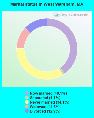
Percentage of family households:
This place:
59.0%
Whole state:
63.0%
Percentage of households with unmarried partners:
This place:
7.4%
Whole state:
7.0%
Likely homosexual households (counted as self-reported same-sex unmarried-partner households)
Lesbian couples: 0.3% of all households
Gay men: 0.2% of all households
Banks with branches in West Wareham (2011 data):
Mayflower Co-operative Bank: West Wareham Branch at 2420 Cranberry Highway, branch established on 2006/12/28. Info updated 2007/02/23: Bank assets: $248.0 mil, Deposits: $222.9 mil, headquarters in Middleboro, MA, positive income, Mortgage Lending Specialization, 8 total offices, Holding Company: Mayflower Bancorp, Inc
Religion statistics for West Wareham, MA (based on Plymouth County data)
Religion
Adherents
Congregations
Catholic
165,985
35
Mainline Protestant
23,724
91
Evangelical Protestant
13,159
96
Other
6,129
43
Orthodox
1,140
3
Black Protestant
611
5
None
284,171
-
Source: Clifford Grammich, Kirk Hadaway, Richard Houseal, Dale E.Jones, Alexei Krindatch, Richie Stanley and Richard H.Taylor. 2012. 2010 U.S.Religion Census: Religious Congregations & Membership Study. Association of Statisticians of American Religious Bodies. Jones, Dale E., et al. 2002. Congregations and Membership in the United States 2000. Nashville, TN: Glenmary Research Center. Graphs represent county-level data
Aircraft: BELL 47G-2 (Category: Land, Seats: 3, Weight: Up to 12,499 Pounds, Speed: 78 mph), Engine: LYCOMING VO-435 SERIES (260 HP) (Reciprocating) N-Number: 2829B, N2829B, N-2829B, Serial Number: 1504, Year manufactured: 1956, Airworthiness Date: 06/23/1961, Certificate Issue Date: 06/09/1993 Registrant (Corporation): Ashley Cranberry Ent Inc, Po Box 280, West Wareham, MA 02576
Aircraft: BELL 47G-3B-1 (Category: Land, Seats: 3, Weight: Up to 12,499 Pounds, Speed: 78 mph), Engine: LYCOMING TV0-435 SER (280 HP) (Reciprocating) N-Number: 47JA, N47JA, N-47JA, Serial Number: 3580, Year manufactured: 1966, Airworthiness Date: 02/13/1975, Certificate Issue Date: 10/22/1992 Registrant (Corporation): Ashley Cranberry Enterprise Inc, Po Box 280, West Wareham, MA 02576
Aircraft: BELL 47G-2A-1 (Category: Land, Seats: 3, Weight: Up to 12,499 Pounds, Speed: 78 mph), Engine: LYCOMING VO-540 SERIES (310 HP) (Reciprocating) N-Number: 73953, N73953, N-73953, Serial Number: 2866, Year manufactured: 1963, Airworthiness Date: 04/23/1980, Certificate Issue Date: 06/09/1993 Registrant (Corporation): Ashley Cranberry Ent Inc, Po Box 280, West Wareham, MA 02576
Aircraft: BELL 47G-3B-2 (Category: Land, Seats: 3, Weight: Up to 12,499 Pounds, Speed: 78 mph), Engine: LYCOMING TV0-435 SER (280 HP) (Turbo-prop) N-Number: 8161K, N8161K, N-8161K, Serial Number: 6743, Year manufactured: 1969, Airworthiness Date: 02/24/1992, Certificate Issue Date: 03/31/2004 Registrant (Individual): James E Ashley, Po Box 280, West Wareham, MA 02576
Aircraft: PIPER PA-28-180 (Category: Land, Seats: 4, Weight: Up to 12,499 Pounds, Speed: 107 mph), Engine: LYCOMING O&VO-360 SER (180 HP) (Reciprocating) N-Number: 9758J, N9758J, N-9758J, Serial Number: 28-3950, Year manufactured: 1967, Airworthiness Date: 03/14/1967, Certificate Issue Date: 08/31/2015 Registrant (Individual): Stephen G Kiarsis, 39 Great Hill Dr, West Wareham, MA 02576
Aircraft: CESSNA 150G (Category: Land, Seats: 2, Weight: Up to 12,499 Pounds, Speed: 90 mph), Engine: CONT MOTOR 0-200 SERIES (100 HP) (4 Cycle) N-Number: 3210J, N3210J, N-3210J, Serial Number: 15065910, Year manufactured: 1966, Airworthiness Date: 01/05/1967, Certificate Issue Date: 01/21/1992 Registrant (Individual): Mary P Dba Gabriel, 1059 Main St, West Wareham, MA 02576, Other Owners: Alliance Argo Deregistered:Cancel Date: 01/18/2018
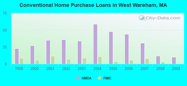
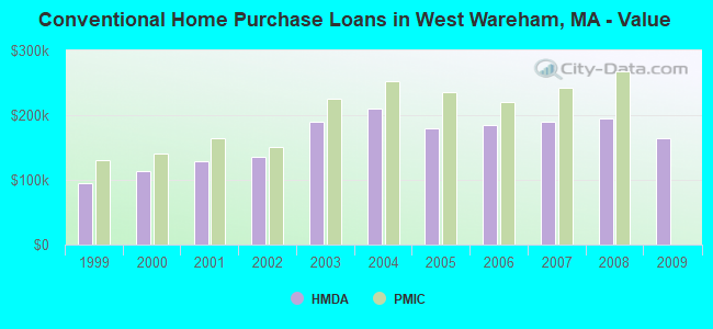
Home Mortgage Disclosure Act Aggregated Statistics For Year 2009 (Based on 1 partial tract)
A) FHA, FSA/RHS & VA Home Purchase Loans
B) Conventional Home Purchase Loans
C) Refinancings
D) Home Improvement Loans
F) Non-occupant Loans on < 5 Family Dwellings (A B C & D)
Number
Average Value
Number
Average Value
Number
Average Value
Number
Average Value
Number
Average Value
LOANS ORIGINATED
10
$217,556
10
$164,549
53
$200,034
4
$143,475
6
$230,418
APPLICATIONS APPROVED, NOT ACCEPTED
0
$0
1
$73,370
3
$295,580
0
$0
0
$0
APPLICATIONS DENIED
4
$199,690
2
$189,605
14
$229,511
2
$112,115
1
$172,770
APPLICATIONS WITHDRAWN
1
$179,440
2
$150,540
8
$214,738
1
$42,240
1
$275,990
FILES CLOSED FOR INCOMPLETENESS
0
$0
0
$0
3
$209,827
0
$0
0
$0
Aggregated Statistics For Year 2008 (Based on 1 partial tract)
A) FHA, FSA/RHS & VA Home Purchase Loans
B) Conventional Home Purchase Loans
C) Refinancings
D) Home Improvement Loans
F) Non-occupant Loans on < 5 Family Dwellings (A B C & D)
G) Loans On Manufactured Home Dwelling (A B C & D)
Number
Average Value
Number
Average Value
Number
Average Value
Number
Average Value
Number
Average Value
Number
Average Value
LOANS ORIGINATED
3
$191,620
12
$195,138
32
$209,288
5
$50,752
6
$192,465
3
$49,017
APPLICATIONS APPROVED, NOT ACCEPTED
0
$0
3
$133,497
6
$191,990
2
$26,045
1
$150,860
2
$61,775
APPLICATIONS DENIED
2
$208,820
2
$131,010
17
$237,714
6
$24,138
2
$289,490
0
$0
APPLICATIONS WITHDRAWN
1
$168,960
1
$133,390
10
$217,048
0
$0
1
$124,180
1
$30,810
FILES CLOSED FOR INCOMPLETENESS
0
$0
0
$0
2
$182,300
0
$0
0
$0
0
$0
Aggregated Statistics For Year 2007 (Based on 1 partial tract)
A) FHA, FSA/RHS & VA Home Purchase Loans
B) Conventional Home Purchase Loans
C) Refinancings
D) Home Improvement Loans
F) Non-occupant Loans on < 5 Family Dwellings (A B C & D)
G) Loans On Manufactured Home Dwelling (A B C & D)
Number
Average Value
Number
Average Value
Number
Average Value
Number
Average Value
Number
Average Value
Number
Average Value
LOANS ORIGINATED
1
$246,780
31
$189,013
51
$186,307
11
$106,281
11
$201,734
3
$48,380
APPLICATIONS APPROVED, NOT ACCEPTED
0
$0
5
$206,312
9
$228,637
1
$34,620
2
$225,970
1
$42,240
APPLICATIONS DENIED
1
$176,590
10
$218,985
38
$224,309
5
$113,002
4
$205,488
1
$30,490
APPLICATIONS WITHDRAWN
0
$0
7
$207,483
10
$225,972
1
$77,810
2
$201,995
0
$0
FILES CLOSED FOR INCOMPLETENESS
0
$0
2
$218,670
5
$236,612
0
$0
0
$0
0
$0
Aggregated Statistics For Year 2006 (Based on 1 partial tract)
A) FHA, FSA/RHS & VA Home Purchase Loans
B) Conventional Home Purchase Loans
C) Refinancings
D) Home Improvement Loans
F) Non-occupant Loans on < 5 Family Dwellings (A B C & D)
G) Loans On Manufactured Home Dwelling (A B C & D)
Number
Average Value
Number
Average Value
Number
Average Value
Number
Average Value
Number
Average Value
Number
Average Value
LOANS ORIGINATED
2
$201,200
44
$185,536
73
$195,589
18
$69,484
10
$174,839
5
$59,200
APPLICATIONS APPROVED, NOT ACCEPTED
0
$0
7
$236,930
13
$143,799
3
$71,567
3
$161,233
1
$67,330
APPLICATIONS DENIED
0
$0
15
$139,363
49
$230,441
8
$105,999
6
$153,083
2
$39,860
APPLICATIONS WITHDRAWN
0
$0
3
$213,850
31
$241,396
0
$0
2
$264,880
0
$0
FILES CLOSED FOR INCOMPLETENESS
0
$0
1
$160,390
5
$220,796
1
$119,740
1
$181,350
0
$0
Aggregated Statistics For Year 2005 (Based on 1 partial tract)
B) Conventional Home Purchase Loans
C) Refinancings
D) Home Improvement Loans
F) Non-occupant Loans on < 5 Family Dwellings (A B C & D)
G) Loans On Manufactured Home Dwelling (A B C & D)
Number
Average Value
Number
Average Value
Number
Average Value
Number
Average Value
Number
Average Value
LOANS ORIGINATED
48
$180,278
90
$194,064
15
$102,818
10
$242,138
5
$57,676
APPLICATIONS APPROVED, NOT ACCEPTED
3
$143,660
10
$190,401
3
$53,463
1
$114,340
0
$0
APPLICATIONS DENIED
10
$163,342
45
$219,095
7
$61,614
1
$270,600
1
$36,210
APPLICATIONS WITHDRAWN
10
$167,979
42
$204,550
5
$152,576
3
$126,933
1
$51,770
FILES CLOSED FOR INCOMPLETENESS
1
$129,900
6
$279,700
0
$0
1
$176,900
0
$0
Aggregated Statistics For Year 2004 (Based on 1 partial tract)
A) FHA, FSA/RHS & VA Home Purchase Loans
B) Conventional Home Purchase Loans
C) Refinancings
D) Home Improvement Loans
F) Non-occupant Loans on < 5 Family Dwellings (A B C & D)
G) Loans On Manufactured Home Dwelling (A B C & D)
Number
Average Value
Number
Average Value
Number
Average Value
Number
Average Value
Number
Average Value
Number
Average Value
LOANS ORIGINATED
2
$265,195
59
$209,390
93
$176,268
10
$87,658
8
$191,512
4
$45,655
APPLICATIONS APPROVED, NOT ACCEPTED
0
$0
6
$169,705
13
$199,892
3
$39,063
0
$0
0
$0
APPLICATIONS DENIED
0
$0
10
$126,468
34
$186,917
6
$53,780
2
$114,810
3
$43,933
APPLICATIONS WITHDRAWN
0
$0
4
$241,692
50
$188,654
3
$55,157
1
$127,040
0
$0
FILES CLOSED FOR INCOMPLETENESS
0
$0
1
$107,030
6
$231,742
0
$0
0
$0
0
$0
Aggregated Statistics For Year 2003 (Based on 1 partial tract)
A) FHA, FSA/RHS & VA Home Purchase Loans
B) Conventional Home Purchase Loans
C) Refinancings
D) Home Improvement Loans
F) Non-occupant Loans on < 5 Family Dwellings (A B C & D)
Number
Average Value
Number
Average Value
Number
Average Value
Number
Average Value
Number
Average Value
LOANS ORIGINATED
5
$210,314
34
$189,449
190
$143,699
7
$60,390
13
$128,066
APPLICATIONS APPROVED, NOT ACCEPTED
2
$163,090
4
$170,392
17
$146,096
1
$123,550
2
$91,630
APPLICATIONS DENIED
0
$0
6
$114,125
39
$157,228
6
$37,372
3
$143,343
APPLICATIONS WITHDRAWN
0
$0
3
$184,420
43
$152,477
1
$10,480
0
$0
FILES CLOSED FOR INCOMPLETENESS
0
$0
1
$263,290
4
$183,415
0
$0
0
$0
Aggregated Statistics For Year 2002 (Based on 1 partial tract)
A) FHA, FSA/RHS & VA Home Purchase Loans
B) Conventional Home Purchase Loans
C) Refinancings
D) Home Improvement Loans
F) Non-occupant Loans on < 5 Family Dwellings (A B C & D)
Number
Average Value
Number
Average Value
Number
Average Value
Number
Average Value
Number
Average Value
LOANS ORIGINATED
4
$160,308
36
$135,509
110
$128,238
9
$25,056
9
$124,888
APPLICATIONS APPROVED, NOT ACCEPTED
1
$237,560
3
$173,303
15
$113,510
2
$35,890
2
$126,405
APPLICATIONS DENIED
0
$0
4
$125,532
23
$123,892
7
$43,011
0
$0
APPLICATIONS WITHDRAWN
0
$0
2
$135,140
30
$135,520
3
$28,373
1
$145,140
FILES CLOSED FOR INCOMPLETENESS
0
$0
0
$0
3
$138,790
1
$31,760
1
$120,370
Aggregated Statistics For Year 2001 (Based on 1 partial tract)
A) FHA, FSA/RHS & VA Home Purchase Loans
B) Conventional Home Purchase Loans
C) Refinancings
D) Home Improvement Loans
F) Non-occupant Loans on < 5 Family Dwellings (A B C & D)
Number
Average Value
Number
Average Value
Number
Average Value
Number
Average Value
Number
Average Value
LOANS ORIGINATED
8
$162,135
35
$128,837
99
$117,368
8
$31,601
10
$113,891
APPLICATIONS APPROVED, NOT ACCEPTED
1
$129,260
3
$179,127
13
$119,345
2
$43,195
0
$0
APPLICATIONS DENIED
1
$149,270
8
$83,886
16
$109,731
6
$26,837
3
$92,103
APPLICATIONS WITHDRAWN
0
$0
3
$133,180
24
$106,224
3
$25,830
1
$75,590
FILES CLOSED FOR INCOMPLETENESS
0
$0
0
$0
2
$98,140
0
$0
0
$0
Aggregated Statistics For Year 2000 (Based on 1 partial tract)
A) FHA, FSA/RHS & VA Home Purchase Loans
B) Conventional Home Purchase Loans
C) Refinancings
D) Home Improvement Loans
F) Non-occupant Loans on < 5 Family Dwellings (A B C & D)
Number
Average Value
Number
Average Value
Number
Average Value
Number
Average Value
Number
Average Value
LOANS ORIGINATED
5
$132,440
27
$113,219
31
$90,004
9
$28,831
4
$156,260
APPLICATIONS APPROVED, NOT ACCEPTED
1
$81,620
4
$89,325
5
$102,140
4
$30,410
1
$82,580
APPLICATIONS DENIED
1
$114,970
4
$73,525
16
$84,482
7
$32,214
1
$40,340
APPLICATIONS WITHDRAWN
1
$125,130
4
$135,060
25
$71,956
2
$40,810
0
$0
FILES CLOSED FOR INCOMPLETENESS
0
$0
0
$0
2
$71,300
0
$0
0
$0
Aggregated Statistics For Year 1999 (Based on 1 partial tract)
A) FHA, FSA/RHS & VA Home Purchase Loans
B) Conventional Home Purchase Loans
C) Refinancings
D) Home Improvement Loans
F) Non-occupant Loans on < 5 Family Dwellings (A B C & D)
Detailed PMIC statistics for the following Tracts:5451.00
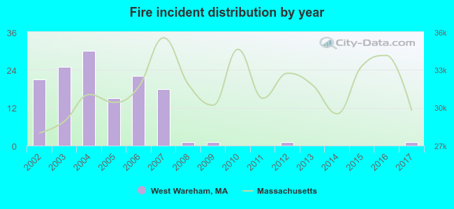
2002 - 2017 National Fire Incident Reporting System (NFIRS) incidents
Based on the data from the years 2002 - 2017 the average number of fires per year is 8. The highest number of fires - 30 took place in 2004, and the least - 0 in 2010. The data has a declining trend.
When looking into fire subcategories, the most reports belonged to: Structure Fires (35.6%), and Outside Fires (33.3%).
Fire incident types reported to NFIRS in West Wareham, MA


 Recent articles from our blog. Our writers, many of them Ph.D. graduates or candidates, create easy-to-read articles on a wide variety of topics.

 (13.5 miles
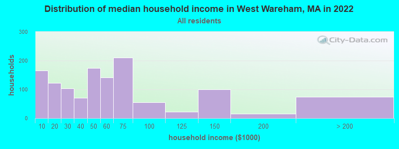


 Based on the data from the years 2002 - 2017 the average number of fires per year is 8. The highest number of fires - 30 took place in 2004, and the least - 0 in 2010. The data has a declining trend.
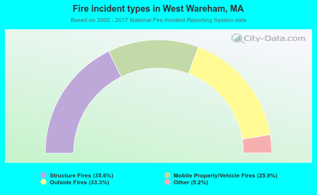 When looking into fire subcategories, the most reports belonged to: Structure Fires (35.6%), and Outside Fires (33.3%).