Bridge Statistics for Middleborough, Massachusetts (MA)
Condition, Traffic, Stress, Structural Evaluation, Project Costs
- National Bridge Inventory (NBI) Statistics
- 42Number of bridges
- 364ft / 111mTotal length
- $85,162,000Total costs
- 709,072Total average daily traffic
- 25,117Total average daily truck traffic
- National Bridge Inventory (NBI) Registered Bridges for Middleborough
- No street view available for this location
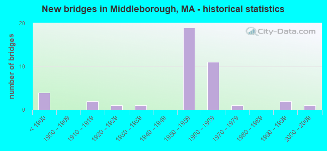
- New bridges - historical statistics
- 4Before 1900
- 21910-1919
- 11920-1929
- 11930-1939
- 191950-1959
- 111960-1969
- 11970-1979
- 21990-1999
- 12000-2009
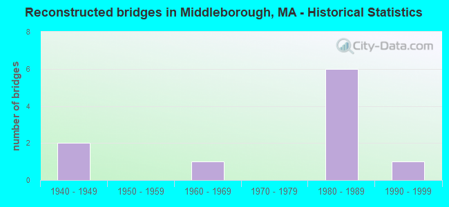
- Reconstructed bridges - Historical Statistics
- 21940-1949
- 01950-1959
- 11960-1969
- 01970-1979
- 61980-1989
- 11990-1999
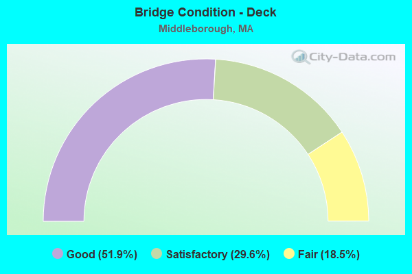
- Bridge Condition - Deck
- 51.9%Good
- 29.6%Satisfactory
- 18.5%Fair
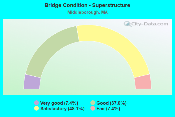
- Bridge Condition - Superstructure
- 7.4%Very good
- 37.0%Good
- 48.1%Satisfactory
- 7.4%Fair
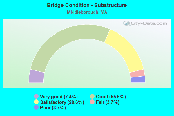
- Bridge Condition - Substructure
- 7.4%Very good
- 55.6%Good
- 29.6%Satisfactory
- 3.7%Fair
- 3.7%Poor
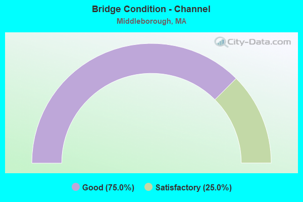
- Bridge Condition - Channel
- 75.0%Good
- 25.0%Satisfactory
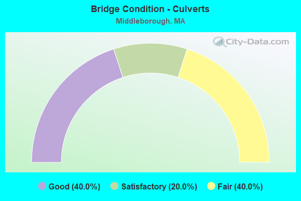
- Bridge Condition - Culverts
- 40.0%Good
- 20.0%Satisfactory
- 40.0%Fair
Find on map >> Show street view
Structure Number: M180074BVDOT634, Location: MBTA MP32/010 (Lat: 41.927014, Lng: -70.934506), Route carried "on" structure: City street , Year Built: 1977, Status: Open, Structure Length: 1.74m (5.71ft), Average Daily Traffic: 1,285 (year 2019), Truck Traffic: 5%, Average Future Daily Traffic: 1,579 (year 2032), Design Load: H 20, Features Intersected: RR MBTA/CSX, Facility Carried by Structure: HWY PLYMOUTH ST
Minimum Vertical Clearance: 30+ m (98+ ft), Kilometerpoint: 4.667, Lanes on structure: 2, Owner: State Highway Agency, Approaching Roadway Width: 8.8m (28.9ft), Skew: 4 degrees, Material/Design: Prestressed concrete, Design/Construction: Slab, Number Of Spans In Main Unit: 1, Length of Maximum Span: 15.8m (51.8ft), Curb or Sidewalk Widths: Left: 1.6m (5.2ft), Right: 0.3m (1.0ft), Curb-To-Curb Width: 9.8m (32.2ft), Out-to-Out Width: 12.6m (41.3ft)
Condition: Deck: Satisfactory, Superstructure: Satisfactory, Substructure: Good, Operating Rating: 50.5 metric tons, Method Used To Determine Operating Rating: Load Factor (LF), Inventory Rating: 30.1 metric tons, Method Used To Determine Inventory Rating: Load Factor (LF), Structural Evaluation: Equal to present minimum criteria, Deck Geometry: Somewhat better than minimum adequacy, Underclear: High priority of corrective action, Approach Roadway Alignment: Equal to present desirable criteria, Length Of Structure Improvement: 1.80m (5.91ft), Designated Inspection Frequency: Every 24 months, Inspection Date: January 2021, Bridge Improvement Cost: $891,000, Roadway Improvement Cost: $90,000, Total Project Cost: $1,337,000 ( Estimate for 2022), Deck Structure Type: Concrete Precast Panels, Wearing Surface/Protective System: Wearing Surface: Bituminous, Membrane: Built-up
Find on map >> Show street view
Structure Number: M18008429MUNNBI, Location: JUST W OF SUMMER ST (Lat: 41.933653, Lng: -70.923328), Route carried "on" structure: City street , Year Built: 1912, Status: Open, Structure Length: 1.07m (3.51ft), Average Daily Traffic: 1,600 (year 2018), Truck Traffic: 8%, Average Future Daily Traffic: 3,080 (year 2031), Features Intersected: WATER NEMASKET RIVER, Facility Carried by Structure: HWY MURDOCK ST
Minimum Vertical Clearance: 30+ m (98+ ft), Kilometerpoint: 1.287, Lanes on structure: 2, Owner: Town or Township Highway Agency, Approaching Roadway Width: 5.5m (18.0ft), Material/Design: Concrete, Design/Construction: Tee Beam, Number Of Spans In Main Unit: 1, Length of Maximum Span: 9.8m (32.2ft), Curb-To-Curb Width: 7.1m (23.3ft), Out-to-Out Width: 8.0m (26.2ft)
Condition: Deck: Good, Superstructure: Good, Substructure: Satisfactory, Channel: Satisfactory, Operating Rating: 58.4 metric tons, Method Used To Determine Operating Rating: Load Factor (LF), Inventory Rating: 35.1 metric tons, Method Used To Determine Inventory Rating: Load Factor (LF), Structural Evaluation: Equal to present minimum criteria, Deck Geometry: High priority of corrective action, Waterway Adequacy: Better than present minimum criteria, Approach Roadway Alignment: Equal to present minimum criteria, Length Of Structure Improvement: 1.10m (3.61ft), Designated Inspection Frequency: Every 24 months, Inspection Date: September 2020, Bridge Improvement Cost: $654,000, Roadway Improvement Cost: $66,000, Total Project Cost: $982,000 ( Estimate for 2022), Deck Structure Type: Concrete Cast-file-Place, Wearing Surface/Protective System: Wearing Surface: Bituminous
Find on map >> Show street view
Structure Number: M180104BWDOT634, Location: 0.1MI SOUTH OF EVERETT ST (Lat: 41.912119, Lng: -70.927019), Route carried "on" structure: City street , Year Built: 1995, Status: Open, Structure Length: 4.33m (14.21ft), Average Daily Traffic: 642 (year 2018), Truck Traffic: 11%, Average Future Daily Traffic: 790 (year 2032), Design Load: HS 20, Features Intersected: RR MBTA/CSX, Facility Carried by Structure: HWY CROSS ST
Minimum Vertical Clearance: 30+ m (98+ ft), Kilometerpoint: 0.000, Lanes on structure: 2, Owner: State Highway Agency, Approaching Roadway Width: 7.3m (24.0ft), Skew: 4 degrees, Material/Design: Steel continuous, Design/Construction: Stringer/Multi-beam, Number Of Spans In Main Unit: 3, Length of Maximum Span: 19.2m (63.0ft), Curb-To-Curb Width: 7.3m (24.0ft), Out-to-Out Width: 8.5m (27.9ft)
Condition: Deck: Good, Superstructure: Very good, Substructure: Very good, Operating Rating: 54.0 metric tons, Method Used To Determine Operating Rating: Allowable Stress (AS), Inventory Rating: 34.7 metric tons, Method Used To Determine Inventory Rating: Allowable Stress (AS), Structural Evaluation: Equal to present desirable criteria, Deck Geometry: Meets minimum limits, Underclear: High priority of corrective action, Approach Roadway Alignment: Equal to present minimum criteria, Length Of Structure Improvement: 4.40m (14.44ft), Designated Inspection Frequency: Every 24 months, Inspection Date: January 2021, Bridge Improvement Cost: $2,033,000, Roadway Improvement Cost: $204,000, Total Project Cost: $3,050,000 ( Estimate for 2022), Deck Structure Type: Concrete Cast-file-Place, Wearing Surface/Protective System: Wearing Surface: Bituminous, Membrane: Built-up, Deck Protection: Epoxy Coated Reinforcing
Find on map >> Show street view
Structure Number: M18012427MUNNBI, Location: JUST SW OF RTE 44 (Lat: 41.906522, Lng: -70.913236), Route carried "on" structure: City street , Year Built: 2004, Status: Open, Structure Length: 2.57m (8.43ft), Average Daily Traffic: 4,000 (year 2020), Truck Traffic: 3%, Average Future Daily Traffic: 3,948 (year 2031), Design Load: HS 20, Features Intersected: WATER NEMASKET RIVER, Facility Carried by Structure: HWY NEMASKET ST
Minimum Vertical Clearance: 30+ m (98+ ft), Kilometerpoint: 0.000, Lanes on structure: 2, Owner: Town or Township Highway Agency, Approaching Roadway Width: 8.9m (29.2ft), Material/Design: Concrete continuous, Design/Construction: Tee Beam, Number Of Spans In Main Unit: 2, Length of Maximum Span: 11.2m (36.7ft), Curb-To-Curb Width: 9.0m (29.5ft), Out-to-Out Width: 10.3m (33.8ft)
Condition: Deck: Good, Superstructure: Very good, Substructure: Very good, Channel: Good, Operating Rating: 82.8 metric tons, Method Used To Determine Operating Rating: Load Factor (LF), Inventory Rating: 49.7 metric tons, Method Used To Determine Inventory Rating: Load Factor (LF), Structural Evaluation: Equal to present desirable criteria, Deck Geometry: Meets minimum limits, Waterway Adequacy: Better than present minimum criteria, Approach Roadway Alignment: Equal to present minimum criteria, Length Of Structure Improvement: 2.60m (8.53ft), Designated Inspection Frequency: Every 24 months, Inspection Date: June 2020, Bridge Improvement Cost: $1,079,000, Roadway Improvement Cost: $108,000, Total Project Cost: $1,619,000 ( Estimate for 2022), Deck Structure Type: Concrete Cast-file-Place, Wearing Surface/Protective System: Wearing Surface: Latex Concrete, Deck Protection: Epoxy Coated Reinforcing
Find on map >> Show street view
Structure Number: M180144BXDOT634, Location: MBTA MP 34/396 (Lat: 41.894358, Lng: -70.919639), Route carried "on" structure: City street , Year Built: 1899, Year Reconstructed: 1997, Status: Open, Structure Length: 1.92m (6.30ft), Average Daily Traffic: 6,214 (year 2019), Truck Traffic: 8%, Average Future Daily Traffic: 18,162 (year 2032), Design Load: HS 20, Features Intersected: RR MBTA/CSX, Facility Carried by Structure: HWY CENTER ST
Minimum Vertical Clearance: 30+ m (98+ ft), Kilometerpoint: 0.000, Lanes on structure: 2, Owner: State Highway Agency, Approaching Roadway Width: 9.7m (31.8ft), Skew: 2 degrees, Material/Design: Prestressed concrete, Design/Construction: Box Beam or Girders - Multiple, Number Of Spans In Main Unit: 1, Length of Maximum Span: 16.2m (53.1ft), Curb or Sidewalk Widths: Left: 1.8m (5.9ft), Right: 1.8m (5.9ft), Curb-To-Curb Width: 9.7m (31.8ft), Out-to-Out Width: 14.1m (46.3ft)
Condition: Deck: Good, Superstructure: Good, Substructure: Good, Operating Rating: 77.7 metric tons, Method Used To Determine Operating Rating: Load Factor (LF), Inventory Rating: 46.6 metric tons, Method Used To Determine Inventory Rating: Load Factor (LF), Structural Evaluation: Better than present minimum criteria, Deck Geometry: High priority of corrective action, Underclear: High priority of corrective action, Approach Roadway Alignment: Somewhat better than minimum adequacy, Length Of Structure Improvement: 2.00m (6.56ft), Designated Inspection Frequency: Every 24 months, Inspection Date: January 2021, Bridge Improvement Cost: $698,000, Roadway Improvement Cost: $70,000, Total Project Cost: $1,048,000 ( Estimate for 2022), Deck Structure Type: Concrete Precast Panels, Wearing Surface/Protective System: Wearing Surface: Bituminous, Membrane: Built-up, Deck Protection: Epoxy Coated Reinforcing
Find on map >> Show street view
Structure Number: M180154BYDOT634, Location: TAUNTON TRACKS MP#34.894 (Lat: 41.887681, Lng: -70.921756), Route carried "on" structure: State highway 28, Year Built: 1850, Year Reconstructed: 1949, Status: Open, Structure Length: 3.02m (9.91ft), Average Daily Traffic: 20,800 (year 2019), Truck Traffic: 4%, Average Future Daily Traffic: 33,481 (year 2032), Design Load: H 20, Features Intersected: RR MBTA/CSX
Minimum Vertical Clearance: 30+ m (98+ ft), Kilometerpoint: 136.372, Lanes on structure: 4, Owner: State Highway Agency, Approaching Roadway Width: 17.2m (56.4ft), Skew: 2 degrees, Material/Design: Steel, Design/Construction: Stringer/Multi-beam, Number Of Spans In Main Unit: 1, Length of Maximum Span: 28.7m (94.2ft), Curb or Sidewalk Widths: Left: 2.3m (7.5ft), Right: 2.3m (7.5ft), Curb-To-Curb Width: 13.5m (44.3ft), Out-to-Out Width: 18.1m (59.4ft)
Condition: Deck: Satisfactory, Superstructure: Satisfactory, Substructure: Good, Operating Rating: 85.0 metric tons, Method Used To Determine Operating Rating: Load Factor (LF), Inventory Rating: 50.9 metric tons, Method Used To Determine Inventory Rating: Load Factor (LF), Structural Evaluation: Equal to present minimum criteria, Deck Geometry: High priority of replacement, Underclear: High priority of corrective action, Approach Roadway Alignment: Equal to present desirable criteria, Length Of Structure Improvement: 3.10m (10.17ft), Designated Inspection Frequency: Every 24 months, Inspection Date: May 2021, Bridge Improvement Cost: $2,514,000, Roadway Improvement Cost: $252,000, Total Project Cost: $3,772,000 ( Estimate for 2022), Deck Structure Type: Concrete Cast-file-Place, Wearing Surface/Protective System: Wearing Surface: Bituminous, Membrane: Built-up
Find on map >> Show street view
Structure Number: M180164C0DOT634, Location: RAILROAD MP 34/894 (Lat: 41.887356, Lng: -70.920733), Route carried "on" structure: State highway 28, Year Built: 1850, Year Reconstructed: 1949, Status: Open, Structure Length: 1.58m (5.18ft), Average Daily Traffic: 20,800 (year 2019), Truck Traffic: 4%, Average Future Daily Traffic: 33,481 (year 2032), Design Load: H 20, Features Intersected: RR MBTA/MACRR
Minimum Vertical Clearance: 30+ m (98+ ft), Kilometerpoint: 137.840, Lanes on structure: 4, Owner: State Highway Agency, Approaching Roadway Width: 13.5m (44.3ft), Material/Design: Steel, Design/Construction: Stringer/Multi-beam, Number Of Spans In Main Unit: 1, Length of Maximum Span: 14.6m (47.9ft), Curb or Sidewalk Widths: Left: 2.3m (7.5ft), Right: 2.3m (7.5ft), Curb-To-Curb Width: 13.5m (44.3ft), Out-to-Out Width: 18.1m (59.4ft)
Condition: Deck: Fair, Superstructure: Satisfactory, Substructure: Good, Operating Rating: 36.0 metric tons, Method Used To Determine Operating Rating: Allowable Stress (AS), Inventory Rating: 28.0 metric tons, Method Used To Determine Inventory Rating: Allowable Stress (AS), Structural Evaluation: Equal to present minimum criteria, Deck Geometry: High priority of replacement, Underclear: High priority of corrective action, Approach Roadway Alignment: Equal to present desirable criteria, Length Of Structure Improvement: 1.60m (5.25ft), Designated Inspection Frequency: Every 24 months, Inspection Date: May 2021, Bridge Improvement Cost: $1,139,000, Roadway Improvement Cost: $114,000, Total Project Cost: $1,709,000 ( Estimate for 2022), Deck Structure Type: Concrete Cast-file-Place, Wearing Surface/Protective System: Wearing Surface: Bituminous, Membrane: Built-up
Find on map >> Show street view
Structure Number: M18017463DOTNBI, Location: .25 MI W OF RTE 28 (Lat: 41.882472, Lng: -70.921031), Route carried "on" structure: Interstate 495, Year Built: 1958, Year Reconstructed: 1987, Status: Open, Structure Length: 5.55m (18.21ft), Average Daily Traffic: 46,800 (year 2018), Truck Traffic: 4%, Average Future Daily Traffic: 94,758 (year 2032), Design Load: HS 20, Features Intersected: COMB ST105 & MBTA/MACRR
Minimum Vertical Clearance: 30+ m (98+ ft), Kilometerpoint: 34.970, Lanes on structure: 6, Lanes under structure: 4, Base Highway Network: Yes, Owner: State Highway Agency, Approaching Roadway Width: 22.6m (74.1ft), Skew: 21 degrees, Material/Design: Steel, Design/Construction: Stringer/Multi-beam, Number Of Spans In Main Unit: 4, Length of Maximum Span: 18.0m (59.1ft), Curb-To-Curb Width: 39.7m (130.2ft), Out-to-Out Width: 40.7m (133.5ft)
Condition: Deck: Satisfactory, Superstructure: Satisfactory, Substructure: Fair, Operating Rating: 52.5 metric tons, Method Used To Determine Operating Rating: Load Factor (LF), Inventory Rating: 31.4 metric tons, Method Used To Determine Inventory Rating: Load Factor (LF), Structural Evaluation: Somewhat better than minimum adequacy, Deck Geometry: Superior to present desirable criteria, Underclear: High priority of corrective action, Approach Roadway Alignment: Equal to present desirable criteria, Length Of Structure Improvement: 5.60m (18.37ft), Designated Inspection Frequency: Every 24 months, Inspection Date: October 2021, Bridge Improvement Cost: $8,953,000, Roadway Improvement Cost: $896,000, Total Project Cost: $13,430,000 ( Estimate for 2022), Deck Structure Type: Concrete Cast-file-Place, Wearing Surface/Protective System: Wearing Surface: Latex Concrete, Deck Protection: Epoxy Coated Reinforcing
Find on map >> Show street view
Structure Number: M180184AKDOTNBI, Location: .5 MI S OF RTE 105 (Lat: 41.882903, Lng: -70.908469), Route carried "on" structure: State highway 28, Year Built: 1930, Status: Open, Structure Length: 1.13m (3.71ft), Average Daily Traffic: 21,400 (year 2018), Truck Traffic: 3%, Average Future Daily Traffic: 34,271 (year 2031), Design Load: H 20, Features Intersected: WATER NEMASKET RIVER
Minimum Vertical Clearance: 30+ m (98+ ft), Kilometerpoint: 134.924, Lanes on structure: 2, Owner: State Highway Agency, Approaching Roadway Width: 11.0m (36.1ft), Skew: 2 degrees, Material/Design: Concrete, Design/Construction: Tee Beam, Number Of Spans In Main Unit: 1, Length of Maximum Span: 10.4m (34.1ft), Curb or Sidewalk Widths: Left: 1.5m (4.9ft), Right: 1.4m (4.6ft), Curb-To-Curb Width: 11.1m (36.4ft), Out-to-Out Width: 14.9m (48.9ft)
Condition: Deck: Satisfactory, Superstructure: Satisfactory, Substructure: Satisfactory, Channel: Good, Operating Rating: 55.2 metric tons, Method Used To Determine Operating Rating: Load Factor (LF), Inventory Rating: 33.0 metric tons, Method Used To Determine Inventory Rating: Load Factor (LF), Structural Evaluation: Equal to present minimum criteria, Deck Geometry: Meets minimum limits, Waterway Adequacy: Equal to present desirable criteria, Approach Roadway Alignment: Equal to present desirable criteria, Length Of Structure Improvement: 1.20m (3.94ft), Designated Inspection Frequency: Every 24 months, Inspection Date: June 2020, Bridge Improvement Cost: $261,000, Roadway Improvement Cost: $27,000, Total Project Cost: $392,000 ( Estimate for 2022), Deck Structure Type: Concrete Cast-file-Place, Wearing Surface/Protective System: Wearing Surface: Bituminous
Find on map >> Show street view
Structure Number: M180204BUDOT634, Location: .5 M S OF ST 28 (Lat: 41.873814, Lng: -70.907067), Route carried "on" structure: City street , Year Built: 1850, Year Reconstructed: 1967, Status: Open, Structure Length: 1.22m (4.00ft), Average Daily Traffic: 4,600 (year 2022), Truck Traffic: 13%, Average Future Daily Traffic: 11,687 (year 2033), Design Load: H 20, Features Intersected: RR MBTA, Facility Carried by Structure: HWY WOOD ST
Minimum Vertical Clearance: 30+ m (98+ ft), Kilometerpoint: 0.000, Lanes on structure: 2, Owner: State Highway Agency, Approaching Roadway Width: 8.2m (26.9ft), Skew: 2 degrees, Material/Design: Prestressed concrete, Design/Construction: Slab, Number Of Spans In Main Unit: 1, Length of Maximum Span: 11.6m (38.1ft), Curb or Sidewalk Widths: Left: 0.2m (0.7ft), Right: 1.5m (4.9ft), Curb-To-Curb Width: 9.8m (32.2ft), Out-to-Out Width: 13.1m (43.0ft)
Condition: Deck: Satisfactory, Superstructure: Satisfactory, Substructure: Good, Operating Rating: 44.4 metric tons, Method Used To Determine Operating Rating: Load Factor (LF), Inventory Rating: 30.2 metric tons, Method Used To Determine Inventory Rating: Load Factor (LF), Structural Evaluation: Equal to present minimum criteria, Deck Geometry: Meets minimum limits, Underclear: High priority of corrective action, Approach Roadway Alignment: Equal to present desirable criteria, Length Of Structure Improvement: 1.30m (4.27ft), Designated Inspection Frequency: Every 24 months, Inspection Date: January 2022, Bridge Improvement Cost: $669,000, Roadway Improvement Cost: $67,000, Total Project Cost: $1,004,000 ( Estimate for 2022), Deck Structure Type: Concrete Precast Panels, Wearing Surface/Protective System: Wearing Surface: Bituminous, Membrane: Built-up
Find on map >> Show street view
Structure Number: M1802249YDOTNBI, Location: 1.3 M S OF RTE 44 (Lat: 41.896228, Lng: -70.897586), Route carried "on" structure: State highway 105, Year Built: 1926, Status: Open, Structure Length: 1.16m (3.81ft), Average Daily Traffic: 4,800 (year 2017), Truck Traffic: 3%, Average Future Daily Traffic: 15,635 (year 2031), Design Load: H 20, Features Intersected: WATER NEMASKET RIVER
Minimum Vertical Clearance: 30+ m (98+ ft), Kilometerpoint: 33.988, Lanes on structure: 2, Owner: State Highway Agency, Approaching Roadway Width: 11.3m (37.1ft), Skew: 1 degrees, Material/Design: Concrete, Design/Construction: Tee Beam, Number Of Spans In Main Unit: 1, Length of Maximum Span: 10.4m (34.1ft), Curb or Sidewalk Widths: Left: 1.5m (4.9ft), Right: 1.5m (4.9ft), Curb-To-Curb Width: 11.3m (37.1ft), Out-to-Out Width: 15.2m (49.9ft)
Condition: Deck: Good, Superstructure: Good, Substructure: Satisfactory, Channel: Good, Operating Rating: 48.4 metric tons, Method Used To Determine Operating Rating: Load Factor (LF), Inventory Rating: 32.0 metric tons, Method Used To Determine Inventory Rating: Load Factor (LF), Structural Evaluation: Equal to present minimum criteria, Deck Geometry: Somewhat better than minimum adequacy, Waterway Adequacy: Equal to present desirable criteria, Approach Roadway Alignment: Equal to present minimum criteria, Length Of Structure Improvement: 1.20m (3.94ft), Designated Inspection Frequency: Every 24 months, Inspection Date: August 2020, Bridge Improvement Cost: $717,000, Roadway Improvement Cost: $72,000, Total Project Cost: $1,076,000 ( Estimate for 2022), Deck Structure Type: Concrete Cast-file-Place, Wearing Surface/Protective System: Wearing Surface: Bituminous
Find on map >> Show street view
Structure Number: M18026428MUNNBI, Location: .2 MI SE OF RTE 105 (Lat: 41.890369, Lng: -70.904544), Route carried "on" structure: City street , Year Built: 1964, Status: Open, Structure Length: 0.76m (2.49ft), Average Daily Traffic: 8,000 (year 2020), Truck Traffic: 3%, Average Future Daily Traffic: 11,845 (year 2031), Features Intersected: WATER NEMASKET RIVER, Facility Carried by Structure: HWY WAREHAM ST
Minimum Vertical Clearance: 30+ m (98+ ft), Kilometerpoint: 0.451, Lanes on structure: 2, Owner: Town or Township Highway Agency, Approaching Roadway Width: 8.5m (27.9ft), Material/Design: Concrete, Design/Construction: Culvert, Number Of Spans In Main Unit: 2, Length of Maximum Span: 3.7m (12.1ft), Curb or Sidewalk Widths: Left: 1.7m (5.6ft), Right: 1.7m (5.6ft), Curb-To-Curb Width: 9.7m (31.8ft), Out-to-Out Width: 13.2m (43.3ft)
Condition: Channel: Good, Culverts: Good, Operating Rating: 74.5 metric tons, Method Used To Determine Operating Rating: Load Factor (LF), Inventory Rating: 44.7 metric tons, Method Used To Determine Inventory Rating: Load Factor (LF), Structural Evaluation: Better than present minimum criteria, Deck Geometry: High priority of corrective action, Waterway Adequacy: Equal to present desirable criteria, Approach Roadway Alignment: Equal to present desirable criteria, Length Of Structure Improvement: 0.40m (1.31ft), Designated Inspection Frequency: Every 24 months, Underwater Inspection Frequency: Every 24 months, Inspection Date: June 2020, Underwater Inspection Date: June 2020, Bridge Improvement Cost: $287,000, Roadway Improvement Cost: $29,000, Total Project Cost: $431,000 ( Estimate for 2022)
Find on map >> Show street view
Structure Number: M180294AGDOTNBI, Location: ADJACENT TO I-495 (Lat: 41.869136, Lng: -70.889508), Route carried "on" structure: City street , Year Built: 1957, Status: Open, Structure Length: 0.70m (2.30ft), Average Daily Traffic: 3,200 (year 2020), Truck Traffic: 4%, Average Future Daily Traffic: 3,474 (year 2031), Design Load: H 20, Features Intersected: WATER FALL BROOK, Facility Carried by Structure: HWY CHERRY ST
Minimum Vertical Clearance: 30+ m (98+ ft), Kilometerpoint: 31.993, Lanes on structure: 2, Owner: State Highway Agency, Approaching Roadway Width: 9.8m (32.2ft), Material/Design: Concrete, Design/Construction: Culvert, Number Of Spans In Main Unit: 1, Length of Maximum Span: 6.1m (20.0ft)
Condition: Channel: Satisfactory, Culverts: Satisfactory, Structural Evaluation: Equal to present minimum criteria, Waterway Adequacy: Better than present minimum criteria, Approach Roadway Alignment: Better than present minimum criteria, Length Of Structure Improvement: 0.40m (1.31ft), Designated Inspection Frequency: Every 24 months, Underwater Inspection Frequency: Every 36 months, Inspection Date: June 2020, Underwater Inspection Date: March 2019, Bridge Improvement Cost: $263,000, Roadway Improvement Cost: $27,000, Total Project Cost: $395,000 ( Estimate for 2022)
Find on map >> Show street view
Structure Number: M1804147CDOTNBI, Location: AT MIDDLEBORO RAYNHAM TL (Lat: 41.923764, Lng: -70.996447), Route carried "on" structure: Interstate 495, Year Built: 1962, Status: Open, Structure Length: 5.18m (16.99ft), Average Daily Traffic: 27,770 (year 2019), Truck Traffic: 3%, Average Future Daily Traffic: 50,064 (year 2032), Design Load: HS 20, Features Intersected: WATER TAUNTON RIVER
Minimum Vertical Clearance: 30+ m (98+ ft), Kilometerpoint: 27.262, Lanes on structure: 2, Base Highway Network: Yes, Owner: State Highway Agency, Approaching Roadway Width: 11.0m (36.1ft), Material/Design: Steel, Design/Construction: Stringer/Multi-beam, Number Of Spans In Main Unit: 3, Length of Maximum Span: 21.3m (69.9ft), Curb-To-Curb Width: 11.6m (38.1ft), Out-to-Out Width: 13.5m (44.3ft)
Condition: Deck: Good, Superstructure: Good, Substructure: Satisfactory, Channel: Good, Operating Rating: 97.4 metric tons, Method Used To Determine Operating Rating: Load Factor (LF), Inventory Rating: 58.3 metric tons, Method Used To Determine Inventory Rating: Load Factor (LF), Structural Evaluation: Equal to present minimum criteria, Deck Geometry: Equal to present minimum criteria, Waterway Adequacy: Equal to present desirable criteria, Approach Roadway Alignment: Equal to present desirable criteria, Length Of Structure Improvement: 5.20m (17.06ft), Designated Inspection Frequency: Every 24 months, Underwater Inspection Frequency: Every 36 months, Inspection Date: October 2021, Underwater Inspection Date: May 2019, Bridge Improvement Cost: $589,000, Roadway Improvement Cost: $59,000, Total Project Cost: $884,000 ( Estimate for 2022), Deck Structure Type: Concrete Cast-file-Place, Wearing Surface/Protective System: Wearing Surface: Bituminous, Membrane: Built-up
Find on map >> Show street view
Structure Number: M1804147EDOTNBI, Location: AT MIDDLEBORO RAYNHAM TL (Lat: 41.923525, Lng: -70.996811), Route carried "on" structure: Interstate 495, Year Built: 1962, Status: Open, Structure Length: 5.19m (17.03ft), Average Daily Traffic: 32,550 (year 2019), Truck Traffic: 2%, Average Future Daily Traffic: 50,064 (year 2032), Design Load: H 20, Features Intersected: WATER TAUNTON RIVER
Minimum Vertical Clearance: 30+ m (98+ ft), Kilometerpoint: 27.262, Lanes on structure: 2, Base Highway Network: Yes, Owner: State Highway Agency, Approaching Roadway Width: 11.0m (36.1ft), Material/Design: Steel, Design/Construction: Stringer/Multi-beam, Number Of Spans In Main Unit: 3, Length of Maximum Span: 21.3m (69.9ft), Curb-To-Curb Width: 11.6m (38.1ft), Out-to-Out Width: 12.6m (41.3ft)
Condition: Deck: Satisfactory, Superstructure: Fair, Substructure: Satisfactory, Channel: Good, Operating Rating: 45.8 metric tons, Method Used To Determine Operating Rating: Allowable Stress (AS), Inventory Rating: 28.0 metric tons, Method Used To Determine Inventory Rating: Allowable Stress (AS), Structural Evaluation: Somewhat better than minimum adequacy, Deck Geometry: Equal to present minimum criteria, Waterway Adequacy: Equal to present desirable criteria, Approach Roadway Alignment: Equal to present desirable criteria, Length Of Structure Improvement: 5.20m (17.06ft), Designated Inspection Frequency: Every 24 months, Underwater Inspection Frequency: Every 36 months, Inspection Date: October 2021, Underwater Inspection Date: May 2019, Bridge Improvement Cost: $2,586,000, Roadway Improvement Cost: $259,000, Total Project Cost: $3,880,000 ( Estimate for 2022), Deck Structure Type: Concrete Cast-file-Place, Wearing Surface/Protective System: Wearing Surface: Bituminous, Membrane: Built-up
Find on map >> Show street view
Structure Number: M180424AYDOTNBI, Location: 0.5 M S OF RAYNHAM TL (Lat: 41.918992, Lng: -70.989808), Route carried "on" structure: City street , Year Built: 1962, Status: Open, Structure Length: 11.80m (38.71ft), Average Daily Traffic: 2,350 (year 2021), Truck Traffic: 6%, Average Future Daily Traffic: 3,553 (year 2032), Design Load: H 20, Features Intersected: I 495, Facility Carried by Structure: HWY VERNON ST
Minimum Vertical Clearance: 30+ m (98+ ft), Kilometerpoint: 1.610, Lanes on structure: 2, Lanes under structure: 4, Owner: State Highway Agency, Approaching Roadway Width: 9.8m (32.2ft), Skew: 5 degrees, Material/Design: Steel continuous, Design/Construction: Stringer/Multi-beam, Number Of Spans In Main Unit: 5, Length of Maximum Span: 30.5m (100.1ft), Curb or Sidewalk Widths: Left: 0.5m (1.6ft), Right: 1.5m (4.9ft), Curb-To-Curb Width: 9.8m (32.2ft), Out-to-Out Width: 12.7m (41.7ft)
Condition: Deck: Good, Superstructure: Satisfactory, Substructure: Good, Operating Rating: 47.9 metric tons, Method Used To Determine Operating Rating: Allowable Stress (AS), Inventory Rating: 25.2 metric tons, Method Used To Determine Inventory Rating: Allowable Stress (AS), Structural Evaluation: Equal to present minimum criteria, Deck Geometry: Meets minimum limits, Underclear: High priority of corrective action, Approach Roadway Alignment: Equal to present desirable criteria, Length Of Structure Improvement: 11.90m (39.04ft), Designated Inspection Frequency: Every 24 months, Inspection Date: November 2021, Bridge Improvement Cost: $5,937,000, Roadway Improvement Cost: $594,000, Total Project Cost: $8,906,000 ( Estimate for 2022), Deck Structure Type: Concrete Cast-file-Place, Wearing Surface/Protective System: Wearing Surface: Bituminous, Membrane: Built-up
Find on map >> Show street view
Structure Number: M180434AADOTNBI, Location: .4 M S OF RTE 28 (Lat: 41.868719, Lng: -70.889639), Route carried "on" structure: City street , Year Built: 1958, Year Reconstructed: 1992, Status: Open, Structure Length: 7.22m (23.69ft), Average Daily Traffic: 900 (year 2018), Truck Traffic: 8%, Average Future Daily Traffic: 2,685 (year 2031), Design Load: H 20, Features Intersected: I 495, Facility Carried by Structure: HWY CHERRY ST
Minimum Vertical Clearance: 30+ m (98+ ft), Kilometerpoint: 0.483, Lanes on structure: 2, Lanes under structure: 4, Owner: State Highway Agency, Approaching Roadway Width: 9.8m (32.2ft), Skew: 2 degrees, Material/Design: Steel, Design/Construction: Stringer/Multi-beam, Number Of Spans In Main Unit: 4, Length of Maximum Span: 23.5m (77.1ft), Curb or Sidewalk Widths: Left: 0.5m (1.6ft), Right: 1.5m (4.9ft), Curb-To-Curb Width: 9.8m (32.2ft), Out-to-Out Width: 12.6m (41.3ft)
Condition: Deck: Good, Superstructure: Good, Substructure: Good, Operating Rating: 51.0 metric tons, Method Used To Determine Operating Rating: Load Factor (LF), Inventory Rating: 30.5 metric tons, Method Used To Determine Inventory Rating: Load Factor (LF), Structural Evaluation: Better than present minimum criteria, Deck Geometry: Equal to present minimum criteria, Underclear: High priority of corrective action, Approach Roadway Alignment: Equal to present desirable criteria, Length Of Structure Improvement: 7.30m (23.95ft), Designated Inspection Frequency: Every 24 months, Inspection Date: December 2020, Bridge Improvement Cost: $3,613,000, Roadway Improvement Cost: $362,000, Total Project Cost: $5,420,000 ( Estimate for 2022), Deck Structure Type: Concrete Cast-file-Place, Wearing Surface/Protective System: Wearing Surface: Monolithic Concrete, Deck Protection: Epoxy Coated Reinforcing
Find on map >> Show street view
Structure Number: M18044461DOTNBI, Location: 1.8 M S OF RTE 105 (Lat: 41.869208, Lng: -70.890439), Route carried "on" structure: Interstate 495, Year Built: 1957, Status: Open, Structure Length: 1.02m (3.35ft), Average Daily Traffic: 35,000 (year 2020), Truck Traffic: 6%, Average Future Daily Traffic: 108,024 (year 2032), Design Load: H 20, Features Intersected: WATER FALL BROOK
Minimum Vertical Clearance: 30+ m (98+ ft), Kilometerpoint: 32.057, Lanes on structure: 4, Base Highway Network: Yes, Owner: State Highway Agency, Approaching Roadway Width: 37.2m (122.0ft), Skew: 24 degrees, Material/Design: Concrete, Design/Construction: Culvert, Number Of Spans In Main Unit: 1, Length of Maximum Span: 8.5m (27.9ft), Curb or Sidewalk Widths: Left: 0.2m (0.7ft), Right: 0.2m (0.7ft), Curb-To-Curb Width: 21.9m (71.9ft), Out-to-Out Width: 39.1m (128.3ft)
Condition: Channel: Good, Culverts: Fair, Operating Rating: 49.4 metric tons, Method Used To Determine Operating Rating: Load Factor (LF), Inventory Rating: 29.6 metric tons, Method Used To Determine Inventory Rating: Load Factor (LF), Structural Evaluation: Somewhat better than minimum adequacy, Deck Geometry: Better than present minimum criteria, Waterway Adequacy: Equal to present desirable criteria, Approach Roadway Alignment: Equal to present desirable criteria, Length Of Structure Improvement: 3.10m (10.17ft), Designated Inspection Frequency: Every 24 months, Inspection Date: June 2021, Bridge Improvement Cost: $894,000, Roadway Improvement Cost: $90,000, Total Project Cost: $1,342,000 ( Estimate for 2022), Deck Structure Type: Concrete Cast-file-Place, Wearing Surface/Protective System: Wearing Surface: Other
Find on map >> Show street view
Structure Number: M180454C1DOT634, Location: .5 M W OF RTE 28 (Lat: 41.867886, Lng: -70.889836), Route carried "on" structure: City street , Year Built: 1957, Year Reconstructed: 1992, Status: Open, Structure Length: 1.10m (3.61ft), Average Daily Traffic: 2,857 (year 2022), Truck Traffic: 7%, Average Future Daily Traffic: 4,738 (year 2033), Design Load: H 20, Features Intersected: RR MACRR, Facility Carried by Structure: HWY CHERRY ST
Minimum Vertical Clearance: 30+ m (98+ ft), Kilometerpoint: 0.805, Lanes on structure: 2, Owner: State Highway Agency, Approaching Roadway Width: 9.8m (32.2ft), Skew: 3 degrees, Material/Design: Steel, Design/Construction: Stringer/Multi-beam, Number Of Spans In Main Unit: 1, Length of Maximum Span: 8.2m (26.9ft), Curb or Sidewalk Widths: Left: 0.3m (1.0ft), Right: 1.6m (5.2ft), Curb-To-Curb Width: 9.8m (32.2ft), Out-to-Out Width: 12.4m (40.7ft)
Condition: Deck: Good, Superstructure: Good, Substructure: Good, Operating Rating: 85.4 metric tons, Method Used To Determine Operating Rating: Load Factor (LF), Inventory Rating: 51.1 metric tons, Method Used To Determine Inventory Rating: Load Factor (LF), Structural Evaluation: Better than present minimum criteria, Deck Geometry: Meets minimum limits, Underclear: High priority of corrective action, Approach Roadway Alignment: Equal to present desirable criteria, Length Of Structure Improvement: 1.20m (3.94ft), Designated Inspection Frequency: Every 24 months, Inspection Date: January 2022, Bridge Improvement Cost: $408,000, Roadway Improvement Cost: $41,000, Total Project Cost: $613,000 ( Estimate for 2022), Deck Structure Type: Concrete Cast-file-Place, Wearing Surface/Protective System: Wearing Surface: Epoxy Overlay, Deck Protection: Epoxy Coated Reinforcing
Find on map >> Show street view
Structure Number: M180474AXDOTNBI, Location: 1.0 M S OF RTE 105 (Lat: 41.875550, Lng: -70.904169), Route carried "on" structure: City street , Year Built: 1958, Status: Open, Structure Length: 6.61m (21.69ft), Average Daily Traffic: 3,839 (year 2019), Truck Traffic: 6%, Average Future Daily Traffic: 6,949 (year 2031), Design Load: H 20, Features Intersected: I 495, Facility Carried by Structure: HWY WOOD ST
Minimum Vertical Clearance: 30+ m (98+ ft), Kilometerpoint: 2.414, Lanes on structure: 2, Lanes under structure: 4, Owner: State Highway Agency, Approaching Roadway Width: 9.1m (29.9ft), Skew: 2 degrees, Material/Design: Steel, Design/Construction: Stringer/Multi-beam, Number Of Spans In Main Unit: 4, Length of Maximum Span: 22.6m (74.1ft), Curb or Sidewalk Widths: Left: 0.3m (1.0ft), Right: 1.5m (4.9ft), Curb-To-Curb Width: 9.8m (32.2ft), Out-to-Out Width: 12.4m (40.7ft)
Condition: Deck: Good, Superstructure: Good, Substructure: Good, Operating Rating: 46.3 metric tons, Method Used To Determine Operating Rating: Load Factor (LF), Inventory Rating: 27.7 metric tons, Method Used To Determine Inventory Rating: Load Factor (LF), Structural Evaluation: Equal to present minimum criteria, Deck Geometry: Meets minimum limits, Underclear: High priority of corrective action, Approach Roadway Alignment: Equal to present desirable criteria, Length Of Structure Improvement: 6.70m (21.98ft), Designated Inspection Frequency: Every 24 months, Inspection Date: December 2020, Bridge Improvement Cost: $3,264,000, Roadway Improvement Cost: $327,000, Total Project Cost: $4,897,000 ( Estimate for 2022), Deck Structure Type: Concrete Cast-file-Place, Wearing Surface/Protective System: Wearing Surface: Bituminous, Membrane: Built-up, Deck Protection: Epoxy Coated Reinforcing
Find on map >> Show street view
Structure Number: M18048ADTDOTNBI, Location: 3 M W OF LAKEVILLE TL (Lat: 41.849336, Lng: -70.858675), Route carried "on" structure: City street , Year Built: 1997, Status: Open, Structure Length: 5.36m (17.59ft), Average Daily Traffic: 2,600 (year 2018), Truck Traffic: 6%, Average Future Daily Traffic: 6,317 (year 2031), Design Load: HS 20, Features Intersected: I 495, Facility Carried by Structure: HWY MILLER ST
Minimum Vertical Clearance: 30+ m (98+ ft), Kilometerpoint: 3.000, Lanes on structure: 2, Lanes under structure: 4, Owner: State Highway Agency, Approaching Roadway Width: 9.8m (32.2ft), Skew: 1 degrees, Material/Design: Steel continuous, Design/Construction: Stringer/Multi-beam, Number Of Spans In Main Unit: 2, Length of Maximum Span: 26.7m (87.6ft), Curb or Sidewalk Widths: Left: 1.4m (4.6ft), Right: 1.4m (4.6ft), Curb-To-Curb Width: 9.8m (32.2ft), Out-to-Out Width: 13.3m (43.6ft)
Condition: Deck: Good, Superstructure: Good, Substructure: Satisfactory, Operating Rating: 78.4 metric tons, Method Used To Determine Operating Rating: Load Factor (LF), Inventory Rating: 47.0 metric tons, Method Used To Determine Inventory Rating: Load Factor (LF), Structural Evaluation: Equal to present minimum criteria, Deck Geometry: Meets minimum limits, Underclear: Meets minimum limits, Approach Roadway Alignment: Equal to present desirable criteria, Length Of Structure Improvement: 5.40m (17.72ft), Designated Inspection Frequency: Every 24 months, Inspection Date: November 2020, Bridge Improvement Cost: $1,833,000, Roadway Improvement Cost: $184,000, Total Project Cost: $2,750,000 ( Estimate for 2022), Deck Structure Type: Concrete Cast-file-Place, Wearing Surface/Protective System: Wearing Surface: Bituminous, Membrane: Built-up, Deck Protection: Epoxy Coated Reinforcing
Find on map >> Show street view
Structure Number: M18049460DOTNBI, Location: 3 M W OF CARVER TL (Lat: 41.846339, Lng: -70.849778), Route carried "on" structure: Interstate 495, Year Built: 1958, Year Reconstructed: 1988, Status: Open, Structure Length: 5.88m (19.29ft), Average Daily Traffic: 49,165 (year 2019), Truck Traffic: 2%, Average Future Daily Traffic: 71,068 (year 2031), Design Load: HS 20+Mod, Features Intersected: ST 28 WAREHAM ST
Minimum Vertical Clearance: 30+ m (98+ ft), Kilometerpoint: 12.239, Lanes on structure: 6, Lanes under structure: 2, Base Highway Network: Yes, Owner: State Highway Agency, Approaching Roadway Width: 21.9m (71.9ft), Skew: 24 degrees, Material/Design: Steel continuous, Design/Construction: Stringer/Multi-beam, Number Of Spans In Main Unit: 3, Length of Maximum Span: 24.4m (80.1ft), Curb or Sidewalk Widths: Left: 0.5m (1.6ft), Right: 0.5m (1.6ft), Curb-To-Curb Width: 38.6m (126.6ft), Out-to-Out Width: 40.1m (131.6ft)
Condition: Deck: Good, Superstructure: Good, Substructure: Good, Operating Rating: 52.4 metric tons, Method Used To Determine Operating Rating: Load Factor (LF), Inventory Rating: 36.5 metric tons, Method Used To Determine Inventory Rating: Load Factor (LF), Structural Evaluation: Better than present minimum criteria, Deck Geometry: Superior to present desirable criteria, Underclear: Meets minimum limits, Approach Roadway Alignment: Equal to present desirable criteria, Length Of Structure Improvement: 5.90m (19.36ft), Designated Inspection Frequency: Every 24 months, Inspection Date: December 2020, Bridge Improvement Cost: $930,000, Roadway Improvement Cost: $94,000, Total Project Cost: $1,396,000 ( Estimate for 2022), Deck Structure Type: Concrete Cast-file-Place, Wearing Surface/Protective System: Wearing Surface: Bituminous, Membrane: Built-up, Deck Protection: Epoxy Coated Reinforcing
Find on map >> Show street view
Structure Number: M18050464DOTNBI, Location: CSX TRACK MP QNB 20.82 (Lat: 41.886600, Lng: -70.931128), Route carried "on" structure: Interstate 495, Year Built: 1958, Status: Open, Structure Length: 2.90m (9.51ft), Average Daily Traffic: 53,500 (year 2019), Truck Traffic: 2%, Average Future Daily Traffic: 63,172 (year 2032), Design Load: H 20, Features Intersected: RR MBTA/CSX QNB 20.82
Minimum Vertical Clearance: 30+ m (98+ ft), Kilometerpoint: 20.348, Lanes on structure: 4, Base Highway Network: Yes, Owner: State Highway Agency, Approaching Roadway Width: 22.6m (74.1ft), Skew: 26 degrees, Material/Design: Steel, Design/Construction: Stringer/Multi-beam, Number Of Spans In Main Unit: 1, Length of Maximum Span: 25.6m (84.0ft), Curb-To-Curb Width: 37.9m (124.3ft), Out-to-Out Width: 38.9m (127.6ft)
Condition: Deck: Good, Superstructure: Satisfactory, Substructure: Good, Operating Rating: 79.7 metric tons, Method Used To Determine Operating Rating: Load Factor (LF), Inventory Rating: 47.8 metric tons, Method Used To Determine Inventory Rating: Load Factor (LF), Structural Evaluation: Equal to present minimum criteria, Deck Geometry: Superior to present desirable criteria, Underclear: Somewhat better than minimum adequacy, Approach Roadway Alignment: Equal to present desirable criteria, Length Of Structure Improvement: 3.00m (9.84ft), Designated Inspection Frequency: Every 24 months, Inspection Date: September 2021, Bridge Improvement Cost: $917,000, Roadway Improvement Cost: $92,000, Total Project Cost: $1,376,000 ( Estimate for 2022), Deck Structure Type: Concrete Cast-file-Place, Wearing Surface/Protective System: Wearing Surface: Bituminous, Membrane: Built-up, Deck Protection: Epoxy Coated Reinforcing
Find on map >> Show street view
Structure Number: M18051462DOTNBI, Location: 1 M S OF RTE 495 / 105 (Lat: 41.878519, Lng: -70.911411), Route carried "on" structure: Interstate 495, Year Built: 1958, Status: Open, Structure Length: 1.31m (4.30ft), Average Daily Traffic: 47,381 (year 2019), Truck Traffic: 2%, Average Future Daily Traffic: 102,654 (year 2031), Design Load: H 20, Features Intersected: WATER NEMASKET RIVER
Minimum Vertical Clearance: 30+ m (98+ ft), Kilometerpoint: 18.346, Lanes on structure: 4, Base Highway Network: Yes, Owner: State Highway Agency, Approaching Roadway Width: 37.2m (122.0ft), Skew: 22 degrees, Material/Design: Concrete, Design/Construction: Tee Beam, Number Of Spans In Main Unit: 1, Length of Maximum Span: 11.9m (39.0ft), Curb or Sidewalk Widths: Left: 0.5m (1.6ft), Right: 0.5m (1.6ft), Curb-To-Curb Width: 37.2m (122.0ft), Out-to-Out Width: 39.0m (128.0ft)
Condition: Deck: Satisfactory, Superstructure: Satisfactory, Substructure: Good, Channel: Good, Operating Rating: 42.3 metric tons, Method Used To Determine Operating Rating: Allowable Stress (AS), Inventory Rating: 25.2 metric tons, Method Used To Determine Inventory Rating: Allowable Stress (AS), Structural Evaluation: Equal to present minimum criteria, Deck Geometry: Superior to present desirable criteria, Waterway Adequacy: Equal to present desirable criteria, Approach Roadway Alignment: Equal to present desirable criteria, Length Of Structure Improvement: 1.40m (4.59ft), Designated Inspection Frequency: Every 24 months, Underwater Inspection Frequency: Every 36 months, Inspection Date: September 2020, Underwater Inspection Date: March 2019, Bridge Improvement Cost: $2,145,000, Roadway Improvement Cost: $215,000, Total Project Cost: $3,218,000 ( Estimate for 2022), Deck Structure Type: Concrete Cast-file-Place, Wearing Surface/Protective System: Wearing Surface: Bituminous
Find on map >> Show street view
Structure Number: M1805247DDOTNBI, Location: 1 M S OF RTE 44 / 495 (Lat: 41.898508, Lng: -70.958506), Route carried "on" structure: State highway 18, Year Built: 1958, Year Reconstructed: 1987, Status: Open, Structure Length: 9.66m (31.69ft), Average Daily Traffic: 26,700 (year 2019), Truck Traffic: 4%, Average Future Daily Traffic: 23,967 (year 2032), Design Load: H 20, Features Intersected: I 495
Minimum Vertical Clearance: 30+ m (98+ ft), Kilometerpoint: 32.233, Lanes on structure: 3, Lanes under structure: 6, Base Highway Network: Yes, Owner: State Highway Agency, Approaching Roadway Width: 14.3m (46.9ft), Skew: 5 degrees, Material/Design: Steel, Design/Construction: Stringer/Multi-beam, Number Of Spans In Main Unit: 4, Length of Maximum Span: 33.2m (108.9ft), Curb or Sidewalk Widths: Left: 1.6m (5.2ft), Right: 0.3m (1.0ft), Curb-To-Curb Width: 13.6m (44.6ft), Out-to-Out Width: 16.2m (53.1ft)
Condition: Deck: Fair, Superstructure: Satisfactory, Substructure: Satisfactory, Operating Rating: 43.7 metric tons, Method Used To Determine Operating Rating: Load Factor (LF), Inventory Rating: 26.2 metric tons, Method Used To Determine Inventory Rating: Load Factor (LF), Structural Evaluation: Equal to present minimum criteria, Deck Geometry: Somewhat better than minimum adequacy, Underclear: High priority of corrective action, Approach Roadway Alignment: Equal to present desirable criteria, Length Of Structure Improvement: 9.70m (31.82ft), Designated Inspection Frequency: Every 24 months, Inspection Date: November 2020, Bridge Improvement Cost: $6,173,000, Roadway Improvement Cost: $618,000, Total Project Cost: $9,260,000 ( Estimate for 2022), Deck Structure Type: Concrete Cast-file-Place, Wearing Surface/Protective System: Wearing Surface: Bituminous, Membrane: Built-up, Deck Protection: Epoxy Coated Reinforcing
Find on map >> Show street view
Structure Number: M1805345DDOTNBI, Location: .1 M N OF RTE 18 / 495 (Lat: 41.902656, Lng: -70.964792), Route carried "on" structure: US 44, Year Built: 1958, Year Reconstructed: 1988, Status: Open, Structure Length: 8.72m (28.61ft), Average Daily Traffic: 32,185 (year 2019), Truck Traffic: 4%, Average Future Daily Traffic: 60,961 (year 2032), Design Load: H 20, Features Intersected: I 495
Minimum Vertical Clearance: 30+ m (98+ ft), Kilometerpoint: 34.037, Lanes on structure: 2, Lanes under structure: 5, Base Highway Network: Yes, Owner: State Highway Agency, Approaching Roadway Width: 14.0m (45.9ft), Skew: 4 degrees, Material/Design: Steel, Design/Construction: Stringer/Multi-beam, Number Of Spans In Main Unit: 4, Length of Maximum Span: 29.9m (98.1ft), Curb or Sidewalk Widths: Left: 1.5m (4.9ft), Right: 1.5m (4.9ft), Curb-To-Curb Width: 14.8m (48.6ft), Out-to-Out Width: 18.7m (61.4ft)
Condition: Deck: Good, Superstructure: Good, Substructure: Satisfactory, Operating Rating: 64.8 metric tons, Method Used To Determine Operating Rating: Load Factor (LF), Inventory Rating: 38.8 metric tons, Method Used To Determine Inventory Rating: Load Factor (LF), Structural Evaluation: Equal to present minimum criteria, Deck Geometry: Superior to present desirable criteria, Underclear: High priority of corrective action, Approach Roadway Alignment: Equal to present desirable criteria, Length Of Structure Improvement: 8.80m (28.87ft), Designated Inspection Frequency: Every 24 months, Inspection Date: November 2020, Bridge Improvement Cost: $1,293,000, Roadway Improvement Cost: $130,000, Total Project Cost: $1,940,000 ( Estimate for 2022), Deck Structure Type: Concrete Cast-file-Place, Wearing Surface/Protective System: Wearing Surface: Latex Concrete, Deck Protection: Epoxy Coated Reinforcing
Find on map >> Show street view
Structure Number: M1805445CDOTNBI, Location: .5 M W OF EVERETT ST (Lat: 41.906761, Lng: -70.924403), Route carried "on" structure: US 44, Year Built: 1963, Status: Open, Structure Length: 2.90m (9.51ft), Average Daily Traffic: 30,300 (year 2018), Truck Traffic: 5%, Average Future Daily Traffic: 43,115 (year 2033), Design Load: H 20, Features Intersected: RR MBTA/CSX
Minimum Vertical Clearance: 30+ m (98+ ft), Kilometerpoint: 35.903, Lanes on structure: 2, Base Highway Network: Yes, Owner: State Highway Agency, Approaching Roadway Width: 13.4m (44.0ft), Material/Design: Prestressed concrete, Design/Construction: Slab, Number Of Spans In Main Unit: 3, Length of Maximum Span: 11.0m (36.1ft), Curb or Sidewalk Widths: Left: 0.5m (1.6ft), Right: 0.5m (1.6ft), Curb-To-Curb Width: 13.5m (44.3ft), Out-to-Out Width: 14.4m (47.2ft)
Condition: Deck: Fair, Superstructure: Fair, Substructure: Poor, Operating Rating: 36.6 metric tons, Method Used To Determine Operating Rating: Allowable Stress (AS), Inventory Rating: 33.1 metric tons, Method Used To Determine Inventory Rating: Allowable Stress (AS), Structural Evaluation: Meets minimum limits, Deck Geometry: Superior to present desirable criteria, Underclear: High priority of corrective action, Approach Roadway Alignment: Equal to present desirable criteria, Length Of Structure Improvement: 3.00m (9.84ft), Designated Inspection Frequency: Every 12 months, Other Special Inspection Frequency: Every 12 months, Inspection Date: Febuary 2022, Other Special Inspection Date: Febuary 2022, Bridge Improvement Cost: $1,697,000, Roadway Improvement Cost: $170,000, Total Project Cost: $2,546,000 ( Estimate for 2022), Deck Structure Type: Concrete Precast Panels, Wearing Surface/Protective System: Wearing Surface: Bituminous, Membrane: Built-up
Find on map >> Show street view
Structure Number: M1805545BDOTNBI, Location: .5 M S OF RTE 44 / RR (Lat: 41.907556, Lng: -70.914908), Route carried "on" structure: US 44, Year Built: 1963, Status: Open, Structure Length: 1.16m (3.81ft), Average Daily Traffic: 30,379 (year 2019), Truck Traffic: 4%, Average Future Daily Traffic: 26,058 (year 2031), Design Load: H 20, Features Intersected: WATER NEMASKET RIVER
Minimum Vertical Clearance: 30+ m (98+ ft), Kilometerpoint: 38.301, Lanes on structure: 2, Base Highway Network: Yes, Owner: State Highway Agency, Approaching Roadway Width: 13.4m (44.0ft), Material/Design: Concrete, Design/Construction: Culvert, Number Of Spans In Main Unit: 3, Length of Maximum Span: 3.7m (12.1ft)
Condition: Channel: Good, Culverts: Good, Operating Rating: 89.9 metric tons, Method Used To Determine Operating Rating: Allowable Stress (AS), Inventory Rating: 21.0 metric tons, Method Used To Determine Inventory Rating: Allowable Stress (AS), Structural Evaluation: Somewhat better than minimum adequacy, Waterway Adequacy: Equal to present desirable criteria, Approach Roadway Alignment: Equal to present desirable criteria, Length Of Structure Improvement: 1.40m (4.59ft), Designated Inspection Frequency: Every 24 months, Inspection Date: June 2020, Bridge Improvement Cost: $638,000, Roadway Improvement Cost: $64,000, Total Project Cost: $958,000 ( Estimate for 2022)
Find on map >> Show street view
Structure Number: M1805645XDOTNBI, Location: 2 M N OF ROCHESTER TL (Lat: 41.824700, Lng: -70.808242), Route carried "on" structure: Interstate 495, Year Built: 1964, Status: Open, Structure Length: 2.59m (8.50ft), Average Daily Traffic: 26,280 (year 2019), Truck Traffic: 5%, Average Future Daily Traffic: 35,534 (year 2031), Design Load: H 20, Features Intersected: HWY PINE ST
Minimum Vertical Clearance: 30+ m (98+ ft), Kilometerpoint: 7.894, Lanes on structure: 2, Lanes under structure: 2, Base Highway Network: Yes, Owner: State Highway Agency, Approaching Roadway Width: 11.4m (37.4ft), Skew: 2 degrees, Material/Design: Steel, Design/Construction: Stringer/Multi-beam, Number Of Spans In Main Unit: 1, Length of Maximum Span: 24.4m (80.1ft), Curb or Sidewalk Widths: Left: 0.2m (0.7ft), Right: 0.5m (1.6ft), Curb-To-Curb Width: 11.6m (38.1ft), Out-to-Out Width: 13.0m (42.7ft)
Condition: Deck: Satisfactory, Superstructure: Satisfactory, Substructure: Good, Operating Rating: 52.7 metric tons, Method Used To Determine Operating Rating: Load Factor (LF), Inventory Rating: 31.6 metric tons, Method Used To Determine Inventory Rating: Load Factor (LF), Structural Evaluation: Equal to present minimum criteria, Deck Geometry: Equal to present minimum criteria, Underclear: High priority of corrective action, Approach Roadway Alignment: Equal to present desirable criteria, Length Of Structure Improvement: 2.60m (8.53ft), Designated Inspection Frequency: Every 24 months, Inspection Date: December 2020, Bridge Improvement Cost: $1,328,000, Roadway Improvement Cost: $133,000, Total Project Cost: $1,993,000 ( Estimate for 2022), Deck Structure Type: Concrete Cast-file-Place, Wearing Surface/Protective System: Wearing Surface: Bituminous, Membrane: Built-up
Find on map >> Show street view
Structure Number: M1805645YDOTNBI, Location: 2 M N OF ROCHESTER TL (Lat: 41.824614, Lng: -70.808792), Route carried "on" structure: Interstate 495, Year Built: 1964, Status: Open, Structure Length: 2.59m (8.50ft), Average Daily Traffic: 24,075 (year 2019), Truck Traffic: 5%, Average Future Daily Traffic: 39,482 (year 2031), Design Load: H 20, Features Intersected: HWY PINE ST
Minimum Vertical Clearance: 30+ m (98+ ft), Kilometerpoint: 7.894, Lanes on structure: 2, Lanes under structure: 2, Base Highway Network: Yes, Owner: State Highway Agency, Approaching Roadway Width: 11.6m (38.1ft), Skew: 2 degrees, Material/Design: Steel, Design/Construction: Stringer/Multi-beam, Number Of Spans In Main Unit: 1, Length of Maximum Span: 24.4m (80.1ft), Curb or Sidewalk Widths: Left: 0.2m (0.7ft), Right: 0.5m (1.6ft), Curb-To-Curb Width: 11.6m (38.1ft), Out-to-Out Width: 13.0m (42.7ft)
Condition: Deck: Fair, Superstructure: Satisfactory, Substructure: Good, Operating Rating: 52.6 metric tons, Method Used To Determine Operating Rating: Load Factor (LF), Inventory Rating: 31.5 metric tons, Method Used To Determine Inventory Rating: Load Factor (LF), Structural Evaluation: Equal to present minimum criteria, Deck Geometry: Equal to present minimum criteria, Underclear: High priority of corrective action, Approach Roadway Alignment: Equal to present desirable criteria, Length Of Structure Improvement: 2.60m (8.53ft), Designated Inspection Frequency: Every 24 months, Inspection Date: December 2020, Bridge Improvement Cost: $1,328,000, Roadway Improvement Cost: $133,000, Total Project Cost: $1,993,000 ( Estimate for 2022), Deck Structure Type: Concrete Cast-file-Place, Wearing Surface/Protective System: Wearing Surface: Bituminous, Membrane: Built-up
Find on map >> Show street view
Structure Number: M1805745ADOTNBI, Location: 1 MI NW OF CARVER TL (Lat: 41.917231, Lng: -70.841550), Route carried "on" structure: US 44, Year Built: 1968, Status: Open, Structure Length: 2.38m (7.81ft), Average Daily Traffic: 32,500 (year 2020), Truck Traffic: 12%, Average Future Daily Traffic: 24,716 (year 2033), Design Load: H 20, Features Intersected: HWY CARMEL ST
Minimum Vertical Clearance: 30+ m (98+ ft), Kilometerpoint: 44.576, Lanes on structure: 2, Lanes under structure: 2, Base Highway Network: Yes, Owner: State Highway Agency, Approaching Roadway Width: 14.6m (47.9ft), Material/Design: Steel, Design/Construction: Stringer/Multi-beam, Number Of Spans In Main Unit: 1, Length of Maximum Span: 23.2m (76.1ft), Curb-To-Curb Width: 13.9m (45.6ft), Out-to-Out Width: 15.5m (50.9ft)
Condition: Deck: Fair, Superstructure: Satisfactory, Substructure: Good, Operating Rating: 55.1 metric tons, Method Used To Determine Operating Rating: Load Factor (LF), Inventory Rating: 33.0 metric tons, Method Used To Determine Inventory Rating: Load Factor (LF), Structural Evaluation: Equal to present minimum criteria, Deck Geometry: Superior to present desirable criteria, Underclear: High priority of corrective action, Approach Roadway Alignment: Equal to present desirable criteria, Length Of Structure Improvement: 2.40m (7.87ft), Designated Inspection Frequency: Every 24 months, Inspection Date: January 2022, Bridge Improvement Cost: $702,000, Roadway Improvement Cost: $71,000, Total Project Cost: $1,054,000 ( Estimate for 2022), Deck Structure Type: Concrete Cast-file-Place, Wearing Surface/Protective System: Wearing Surface: Bituminous, Membrane: Built-up
Find on map >> Show street view
Structure Number: M18060441MUNNBI, Location: .1 MI E OF LAKEVILLE (Lat: 41.814733, Lng: -70.898292), Route carried "on" structure: City street , Year Built: 1910, Status: Open, Structure Length: 1.04m (3.41ft), Average Daily Traffic: 600 (year 2018), Truck Traffic: 11%, Average Future Daily Traffic: 2,527 (year 2031), Features Intersected: WATER POCKSHA POND, Facility Carried by Structure: HWY LONG PT RD
Minimum Vertical Clearance: 30+ m (98+ ft), Kilometerpoint: 0.016, Lanes on structure: 2, Owner: Town or Township Highway Agency, Approaching Roadway Width: 7.3m (24.0ft), Material/Design: Masonry, Design/Construction: Culvert, Number Of Spans In Main Unit: 3, Length of Maximum Span: 2.7m (8.9ft)
Condition: Channel: Satisfactory, Culverts: Fair, Operating Rating: 34.7 metric tons, Method Used To Determine Operating Rating: Allowable Stress (AS), Inventory Rating: 22.7 metric tons, Method Used To Determine Inventory Rating: Allowable Stress (AS), Structural Evaluation: Somewhat better than minimum adequacy, Waterway Adequacy: Equal to present minimum criteria, Approach Roadway Alignment: Equal to present desirable criteria, Length Of Structure Improvement: 0.80m (2.62ft), Designated Inspection Frequency: Every 24 months, Underwater Inspection Frequency: Every 24 months, Inspection Date: October 2020, Underwater Inspection Date: November 2020, Bridge Improvement Cost: $327,000, Roadway Improvement Cost: $33,000, Total Project Cost: $491,000 ( Estimate for 2022)
Find on map >> Show street view
Structure Number: M180424AYDOTNBI, Location: 0.5 M S OF RAYNHAM TL (Lat: 41.916667, Lng: -70.983333), Route carried "under" structure: Interstate 495, Year Built: 1962, Structure Length: 0. m, Average Daily Traffic: 10,000 (year 0000), Features Intersected: I 495 NB, Facility Carried by Structure: HWY VERNON ST
Minimum Vertical Clearance: 4.32m (14.17ft), Kilometerpoint: 4.345, Lanes on structure: 2, Lanes under structure: 2, Material/Design: Steel, Design/Construction: Stringer/Multi-beam, Length of Maximum Span: 30.2m (99.1ft)
Find on map >> Show street view
Structure Number: M180424AYDOTNBI, Location: 0.5 M S OF RAYNHAM TL (Lat: 41.916667, Lng: -70.983333), Route carried "under" structure: Interstate 495, Year Built: 1962, Structure Length: 0. m, Average Daily Traffic: 10,000 (year 0000), Features Intersected: I 495 SB, Facility Carried by Structure: HWY VERNON ST
Minimum Vertical Clearance: 4.32m (14.17ft), Kilometerpoint: 4.345, Lanes on structure: 2, Lanes under structure: 2, Material/Design: Steel, Design/Construction: Stringer/Multi-beam, Length of Maximum Span: 30.2m (99.1ft)
Find on map >> Show street view
Structure Number: M180434AADOTNBI, Location: 0.3 M W OF RTE 105 (Lat: 41.866667, Lng: -70.883333), Route carried "under" structure: Interstate 495, Year Built: 1958, Structure Length: 0. m, Average Daily Traffic: 10,500 (year 0000), Features Intersected: I 495 NB, Facility Carried by Structure: HWY CHERRY ST
Minimum Vertical Clearance: 4.34m (14.24ft), Kilometerpoint: 7.338, Lanes on structure: 2, Lanes under structure: 2, Material/Design: Steel, Design/Construction: Stringer/Multi-beam, Length of Maximum Span: 23.5m (77.1ft)
Find on map >> Show street view
Structure Number: M180434AADOTNBI, Location: 0.3 M W OF RTE 105 (Lat: 41.866667, Lng: -70.883333), Route carried "under" structure: Interstate 495, Year Built: 1958, Structure Length: 0. m, Average Daily Traffic: 10,500 (year 0000), Features Intersected: I 495 SB, Facility Carried by Structure: HWY CHERRY ST
Minimum Vertical Clearance: 4.34m (14.24ft), Kilometerpoint: 7.338, Lanes on structure: 2, Lanes under structure: 2, Material/Design: Steel, Design/Construction: Stringer/Multi-beam, Length of Maximum Span: 23.8m (78.1ft)
Find on map >> Show street view
Structure Number: M180474AXDOTNBI, Location: 1.0 M S OF RTE 105 (Lat: 41.883333, Lng: -70.900000), Route carried "under" structure: Interstate 495, Year Built: 1958, Structure Length: 0. m, Average Daily Traffic: 10,500 (year 0000), Features Intersected: I 495 NB, Facility Carried by Structure: HWY WOOD ST
Minimum Vertical Clearance: 4.47m (14.67ft), Kilometerpoint: 5.890, Lanes on structure: 2, Lanes under structure: 2, Material/Design: Steel, Design/Construction: Stringer/Multi-beam, Length of Maximum Span: 22.6m (74.1ft)
Find on map >> Show street view
Structure Number: M180474AXDOTNBI, Location: 1.0 M S OF RTE 105 (Lat: 41.883333, Lng: -70.900000), Route carried "under" structure: Interstate 495, Year Built: 1958, Structure Length: 0. m, Average Daily Traffic: 10,500 (year 0000), Features Intersected: I 495 SB, Facility Carried by Structure: HWY WOOD ST
Minimum Vertical Clearance: 4.47m (14.67ft), Kilometerpoint: 5.890, Lanes on structure: 2, Lanes under structure: 2, Material/Design: Steel, Design/Construction: Stringer/Multi-beam, Length of Maximum Span: 22.6m (74.1ft)
Find on map >> Show street view
Structure Number: M1805247DDOTNBI, Location: 1.0 M S OF RTE 44 / 495 (Lat: 41.900000, Lng: -70.966667), Route carried "under" structure: Interstate 495, Year Built: 1958, Structure Length: 0. m, Average Daily Traffic: 10,500 (year 0000), Features Intersected: I 495 NB, Facility Carried by Structure: ST 18 BEDFORD ST
Minimum Vertical Clearance: 4.37m (14.34ft), Kilometerpoint: 0.756, Lanes on structure: 4, Lanes under structure: 2, Material/Design: Steel, Design/Construction: Stringer/Multi-beam, Length of Maximum Span: 34.1m (111.9ft)
Find on map >> Show street view
Structure Number: M1805247DDOTNBI, Location: 1.0 M S OF RTE 44 / 495 (Lat: 41.900000, Lng: -70.966667), Route carried "under" structure: Interstate 495, Year Built: 1958, Structure Length: 0. m, Average Daily Traffic: 10,500 (year 0000), Features Intersected: I 495 SB, Facility Carried by Structure: ST 18 BEDFORD ST
Minimum Vertical Clearance: 4.37m (14.34ft), Kilometerpoint: 0.756, Lanes on structure: 4, Lanes under structure: 2, Material/Design: Steel, Design/Construction: Stringer/Multi-beam, Length of Maximum Span: 34.1m (111.9ft)
Find on map >> Show street view
Structure Number: M1805345DDOTNBI, Location: 1.0 M N OF RTE 18 / 495 (Lat: 41.900000, Lng: -70.966667), Route carried "under" structure: Interstate 495, Year Built: 1958, Structure Length: 0. m, Average Daily Traffic: 10,500 (year 0000), Features Intersected: I 495 SB, Facility Carried by Structure: US 44 HARDING ST
Minimum Vertical Clearance: 4.27m (14.01ft), Kilometerpoint: 0.000, Lanes on structure: 4, Lanes under structure: 2, Material/Design: Steel, Design/Construction: Stringer/Multi-beam, Length of Maximum Span: 29.9m (98.1ft)
Find on map >> Show street view
Structure Number: M1805345DDOTNBI, Location: 1.0 M N OF RTE 18 / 495 (Lat: 41.900000, Lng: -70.966667), Route carried "under" structure: Interstate 495, Year Built: 1958, Structure Length: 0. m, Average Daily Traffic: 10,500 (year 0000), Features Intersected: I 495 NB, Facility Carried by Structure: US 44 HARDING ST
Minimum Vertical Clearance: 4.27m (14.01ft), Kilometerpoint: 0.000, Lanes on structure: 4, Lanes under structure: 2, Material/Design: Steel, Design/Construction: Stringer/Multi-beam, Length of Maximum Span: 29.9m (98.1ft)