Lower Christiana, Delaware
Submit your own pictures of this place and show them to the world
- OSM Map
- General Map
- Google Map
- MSN Map

| Males: 18,595 | |
| Females: 19,523 |
| Median resident age: | 37.0 years |
| Delaware median age: | 36.0 years |
Zip code: 19804
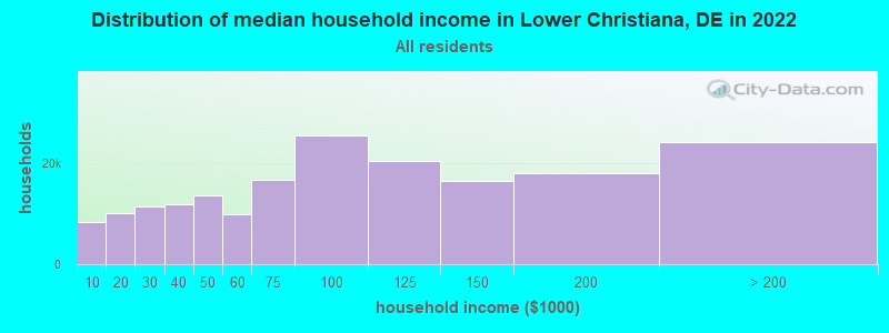
| Lower Christiana: | $71,282 |
| DE: | $82,174 |
Estimated per capita income in 2022: $35,936 (it was $20,839 in 2000)
Lower Christiana CCD income, earnings, and wages data
Estimated median house or condo value in 2022: $266,662 (it was $107,100 in 2000)
| Lower Christiana: | $266,662 |
| DE: | $337,200 |
Mean prices in 2022: all housing units: $377,702; detached houses: $422,634; townhouses or other attached units: $276,374; in 2-unit structures: $193,032; in 3-to-4-unit structures: $559,065; in 5-or-more-unit structures: $187,236; mobile homes: $63,843; occupied boats, rvs, vans, etc.: $129,840
Lower Christiana, DE residents, houses, and apartments details
Detailed information about poverty and poor residents in Lower Christiana, DE


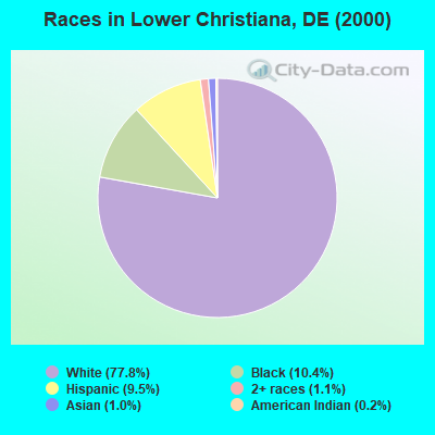
- 28,21377.8%White alone
- 3,76510.4%Black alone
- 3,4329.5%Hispanic
- 3911.1%Two or more races
- 3511.0%Asian alone
- 640.2%American Indian alone
- 260.07%Other race alone
- 80.02%Native Hawaiian and Other
Pacific Islander alone
Races in Lower Christiana detailed stats: ancestries, foreign born residents, place of birth
 Recent articles from our blog. Our writers, many of them Ph.D. graduates or candidates, create easy-to-read articles on a wide variety of topics.
Current Local Time: EST time zone
Land area: 11.6 square miles.
Population density: 3,278 people per square mile (average).

| Lower Christiana CCD: | 0.7% ($722) |
| Delaware: | 0.7% ($841) |
Nearest city with pop. 50,000+: Wilmington, DE  (2.9 miles , pop. 72,664).
Nearest city with pop. 200,000+: Philadelphia, PA (30.5 miles , pop. 1,517,550).
Nearest cities:
), ), ), ), ), ), Latitude: 39.73 N, Longitude: 75.60 W
Area code commonly used in this area: 302

| Here: | 3.5% |
| Delaware: | 3.7% |
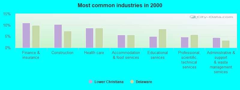
- Finance & insurance (11.1%)
- Construction (10.4%)
- Health care (8.8%)
- Accommodation & food services (5.7%)
- Educational services (5.0%)
- Professional, scientific, technical services (4.8%)
- Administrative & support & waste management services (4.5%)
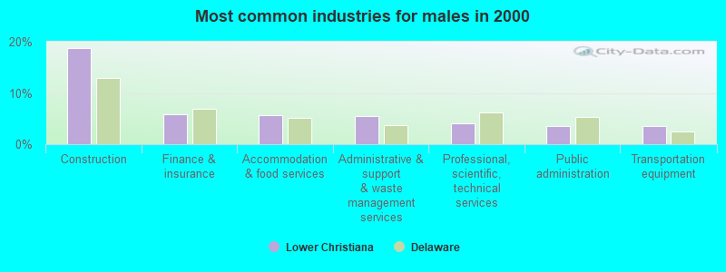
- Construction (18.7%)
- Finance & insurance (5.9%)
- Accommodation & food services (5.7%)
- Administrative & support & waste management services (5.6%)
- Professional, scientific, technical services (4.1%)
- Public administration (3.6%)
- Transportation equipment (3.6%)
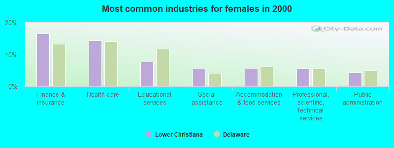
- Finance & insurance (16.5%)
- Health care (14.5%)
- Educational services (7.7%)
- Social assistance (5.8%)
- Accommodation & food services (5.7%)
- Professional, scientific, technical services (5.6%)
- Public administration (4.3%)
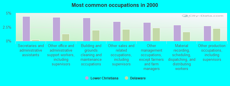
- Secretaries and administrative assistants (4.4%)
- Other office and administrative support workers, including supervisors (4.3%)
- Building and grounds cleaning and maintenance occupations (4.2%)
- Other sales and related occupations, including supervisors (3.5%)
- Other management occupations, except farmers and farm managers (3.3%)
- Material recording, scheduling, dispatching, and distributing workers (2.9%)
- Other production occupations, including supervisors (2.7%)
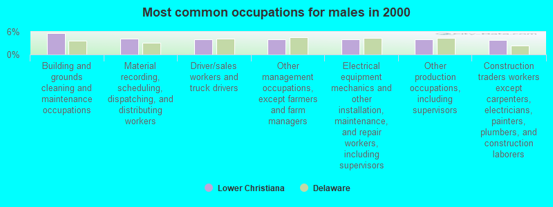
- Building and grounds cleaning and maintenance occupations (5.7%)
- Material recording, scheduling, dispatching, and distributing workers (4.2%)
- Driver/sales workers and truck drivers (4.1%)
- Other management occupations, except farmers and farm managers (4.0%)
- Electrical equipment mechanics and other installation, maintenance, and repair workers, including supervisors (4.0%)
- Other production occupations, including supervisors (4.0%)
- Construction traders workers except carpenters, electricians, painters, plumbers, and construction laborers (3.8%)
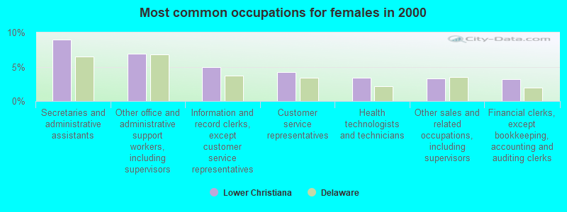
- Secretaries and administrative assistants (9.0%)
- Other office and administrative support workers, including supervisors (6.9%)
- Information and record clerks, except customer service representatives (4.9%)
- Customer service representatives (4.2%)
- Health technologists and technicians (3.4%)
- Other sales and related occupations, including supervisors (3.2%)
- Financial clerks, except bookkeeping, accounting and auditing clerks (3.2%)
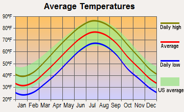
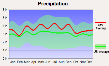
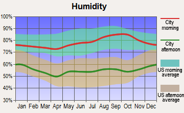
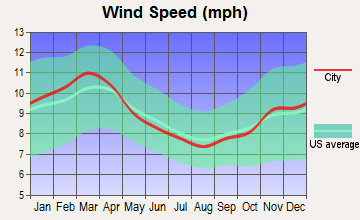
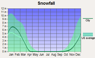
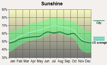
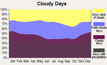
Average climate in Lower Christiana, Delaware
Based on data reported by over 4,000 weather stations
(lower is better)
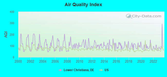
Air Quality Index (AQI) level in 2023 was 103. This is significantly worse than average.
| City: | 103 |
| U.S.: | 73 |

Carbon Monoxide (CO) [ppm] level in 2021 was 0.259. This is about average. Closest monitor was 2.4 miles away from the city center.
| City: | 0.259 |
| U.S.: | 0.251 |
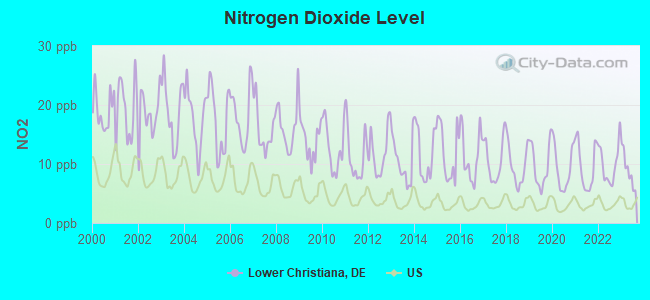
Nitrogen Dioxide (NO2) [ppb] level in 2023 was 8.99. This is significantly worse than average. Closest monitor was 2.4 miles away from the city center.
| City: | 8.99 |
| U.S.: | 5.11 |
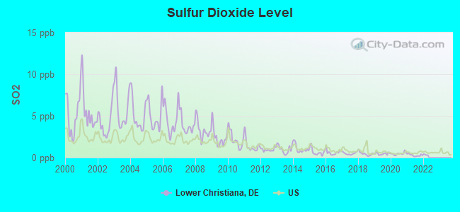
Sulfur Dioxide (SO2) [ppb] level in 2021 was 0.282. This is significantly better than average. Closest monitor was 1.0 miles away from the city center.
| City: | 0.282 |
| U.S.: | 1.515 |
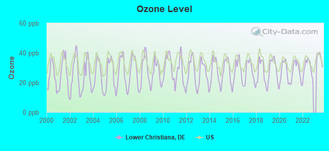
Ozone [ppb] level in 2023 was 36.5. This is about average. Closest monitor was 2.4 miles away from the city center.
| City: | 36.5 |
| U.S.: | 33.3 |
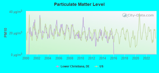
Particulate Matter (PM10) [µg/m3] level in 2015 was 16.7. This is about average. Closest monitor was 2.2 miles away from the city center.
| City: | 16.7 |
| U.S.: | 19.2 |
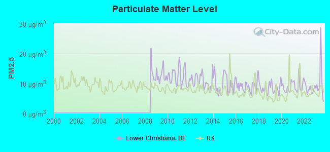
Particulate Matter (PM2.5) [µg/m3] level in 2023 was 10.4. This is worse than average. Closest monitor was 2.4 miles away from the city center.
| City: | 10.4 |
| U.S.: | 8.1 |
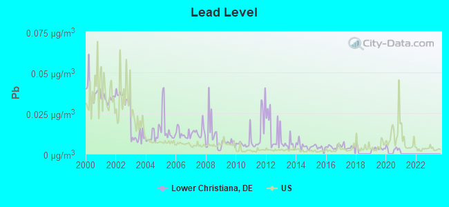
Lead (Pb) [µg/m3] level in 2020 was 0.00328. This is significantly better than average. Closest monitor was 2.4 miles away from the city center.
| City: | 0.00328 |
| U.S.: | 0.00931 |
Tornado activity:
Lower Christiana-area historical tornado activity is slightly above Delaware state average. It is 8% greater than the overall U.S. average.
On 4/28/1961, a category F3 (max. wind speeds 158-206 mph) tornado 4.6 miles away from the Lower Christiana place center caused between $5000 and $50,000 in damages.
On 7/27/1994, a category F3 tornado 9.2 miles away from the place center injured 11 people and caused between $500,000 and $5,000,000 in damages.
Earthquake activity:
Lower Christiana-area historical earthquake activity is significantly above Delaware state average. It is 64% smaller than the overall U.S. average.On 8/23/2011 at 17:51:04, a magnitude 5.8 (5.8 MW, Depth: 3.7 mi, Class: Moderate, Intensity: VI - VII) earthquake occurred 178.0 miles away from Lower Christiana center
On 1/16/1994 at 01:49:16, a magnitude 4.6 (4.6 MB, 4.6 LG, Depth: 3.1 mi, Class: Light, Intensity: IV - V) earthquake occurred 47.4 miles away from the city center
On 1/16/1994 at 00:42:43, a magnitude 4.2 (4.2 MB, 4.0 LG, Depth: 3.1 mi) earthquake occurred 46.4 miles away from the city center
On 11/30/2017 at 21:47:31, a magnitude 4.1 (4.1 MW, Depth: 6.1 mi) earthquake occurred 38.0 miles away from the city center
On 9/25/1998 at 19:52:52, a magnitude 5.2 (4.8 MB, 4.3 MS, 5.2 LG, 4.5 MW, Depth: 3.1 mi) earthquake occurred 279.5 miles away from Lower Christiana center
On 10/7/1983 at 10:18:46, a magnitude 5.3 (5.1 MB, 5.3 LG, 5.1 ML) earthquake occurred 299.1 miles away from the city center
Magnitude types: regional Lg-wave magnitude (LG), body-wave magnitude (MB), local magnitude (ML), surface-wave magnitude (MS), moment magnitude (MW)
Natural disasters:
The number of natural disasters in New Castle County (15) is near the US average (15).Major Disasters (Presidential) Declared: 9
Emergencies Declared: 5
Causes of natural disasters: Hurricanes: 7, Snowstorms: 2, Tropical Storms: 2, Winter Storms: 2, Blizzard: 1, Flood: 1, Snowfall: 1, Storm: 1, Tornado: 1, Water Shortage: 1, Other: 1 (Note: some incidents may be assigned to more than one category).
Hospitals and medical centers near Lower Christiana:
- WILMINGTON VA MEDICAL CENTER (Hospital, Acute Care - Veterans Administration, about 1 miles away; WILMINGTON, DE)
- GENERATIONS HOME CARE, INC. (Home Health Center, about 1 miles away; WILMINGTON, DE)
- EMILY BISSELL HOSP (Nursing Home, about 2 miles away; WILMINGTON, DE)
- FRESENIUS MEDICAL CARE NEWPORT PIKE (Dialysis Facility, about 2 miles away; WILMINGTON, DE)
- BRANDYWINE NURSING AND REHABILITATION CENTER (Nursing Home, about 2 miles away; WILMINGTON, DE)
- HILLSIDE CENTER (Nursing Home, about 2 miles away; WILMINGTON, DE)
- PARKVIEW NURSING (Nursing Home, about 2 miles away; WILMINGTON, DE)
Amtrak stations near Lower Christiana:
- 3 miles: WILMINGTON (M. L. KING BLVD, & FRENCH ST.) . Services: ticket office, partially wheelchair accessible, enclosed waiting area, public restrooms, public payphones, snack bar, ATM, paid short-term parking, paid long-term parking, car rental agency, taxi stand, intercity bus service, public transit connection.
- 10 miles: NEWARK (429 S. COLLEGE AVE.) . Services: public payphones, free short-term parking, call for car rental service, call for taxi service, public transit connection.
- 20 miles: DOWNINGTOWN (VIADUCT AVE.) . Services: public payphones, paid short-term parking, call for car rental service, call for taxi service, public transit connection.
Operable nuclear power plants near Lower Christiana:
- 14 miles: Salem 2 in Salem, NJ.
- 14 miles: Hope Creek in Salem, NJ.
- 14 miles: Salem 1 in Salem, NJ.
Colleges/universities with over 2000 students nearest to Lower Christiana:
- Delaware Technical Community College-Stanton/Wilmington (about 3 miles; Wilmington, DE; Full-time enrollment: 4,972)
- Wilmington University (about 4 miles; New Castle, DE; FT enrollment: 10,072)
- University of Delaware (about 9 miles; Newark, DE; FT enrollment: 20,078)
- Neumann University (about 14 miles; Aston, PA; FT enrollment: 2,622)
- West Chester University of Pennsylvania (about 16 miles; West Chester, PA; FT enrollment: 14,492)
- Widener University-Main Campus (about 16 miles; Chester, PA; FT enrollment: 4,051)
- Lincoln University of Pennsylvania (about 19 miles; Lincoln University, PA; FT enrollment: 2,042)
Points of interest:
Notable locations in Lower Christiana: Germany Industrial Park (A), Boxwood Industrial Park (B), Prices Corner Center (C), Wilsmere Yards (D), West Yard (E), First State Industrial Park (F), Professional Plaza Business Park (G), Newport Industrial Park (H), Cranston Heights Fire Company (I), Minquas Fire Company Number 1 Station 23 (J), Care First Transportation Ambulance Service (K), New Castle County Emergency Medical Services Paramedic Station 7 (L), Delaware State Police Troop 6 (M), Newport Police Department (N), Elsmere Police Department (O), John L Webb Correctional Facility (P), Absalom Jones Community Center (Q), Elsmere Library (R), Elsmere Town Hall (S), New Castle County Detention Center (T). Display/hide their locations on the map
Shopping Centers: Canby Park Shopping Center (1), Chestnut Run Shopping Center (2). Display/hide their locations on the map
Churches in Lower Christiana include: Saint James Church (A), Richardson Park Church (B), Antioch Christian Center (C), Deliverance Apostical Church (D), Church of the Brethren (E), Sikh Center of Delaware (F), Saint Matthews Catholic Church (G), Corpus Christi Roman Catholic Church (H), Abundant Life Church (I). Display/hide their locations on the map
Cemeteries: Beth Emeth Cemetery (1), Saint James Cemetery (2), Cathedral Cemetery (3), Simpson Cemetery (4), Silverbrook Cemetery (5). Display/hide their locations on the map
Streams, rivers, and creeks: Hyde Run (A), Chestnut Run (B), Little Mill Creek (C), White Clay Creek (D). Display/hide their locations on the map
Parks in Lower Christiana include: Banning Park (1), Canby Park (2), Pleasant Hills Park (3), Biden Park (4). Display/hide their locations on the map
| This place: | 2.5 people |
| Delaware: | 2.5 people |
| This place: | 64.6% |
| Whole state: | 67.4% |
| This place: | 9.0% |
| Whole state: | 7.3% |
Likely homosexual households (counted as self-reported same-sex unmarried-partner households)
- Lesbian couples: 0.5% of all households
- Gay men: 0.3% of all households
| This place: | 8.6% |
| Whole state: | 9.2% |
| This place: | 4.3% |
| Whole state: | 4.4% |
People in group quarters in Lower Christiana in 2010:
- 164 people in correctional facilities intended for juveniles
- 65 people in nursing facilities/skilled-nursing facilities
- 60 people in state prisons
- 12 people in group homes intended for adults
- 7 people in other noninstitutional facilities
- 5 people in group homes for juveniles (non-correctional)
People in group quarters in Lower Christiana in 2000:
- 124 people in other types of correctional institutions
- 69 people in homes or halfway houses for drug/alcohol abuse
- 38 people in other noninstitutional group quarters
- 18 people in training schools for juvenile delinquents
- 14 people in religious group quarters
- 9 people in homes for the mentally ill
- 4 people in other nonhousehold living situations
For population 15 years and over in Lower Christiana:
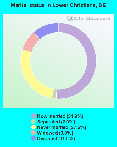
- Never married: 27.5%
- Now married: 51.9%
- Separated: 2.0%
- Widowed: 9.0%
- Divorced: 11.6%
For population 25 years and over in Lower Christiana:
- High school or higher: 79.0%
- Bachelor's degree or higher: 13.7%
- Graduate or professional degree: 4.0%
- Unemployed: 4.9%
- Mean travel time to work (commute): 20.6 minutes
| Here: | 10.9 |
| Delaware average: | 11.9 |
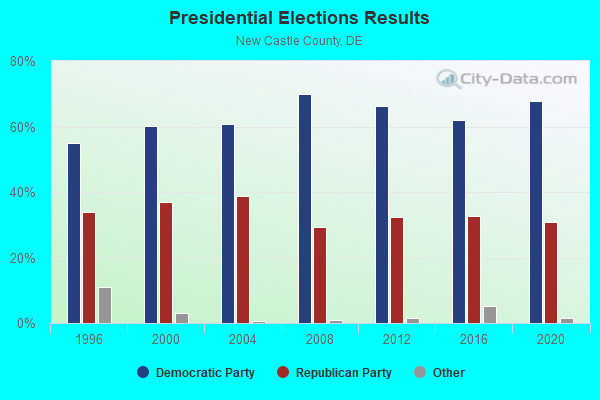
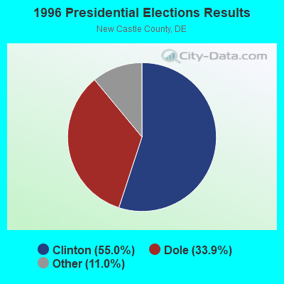
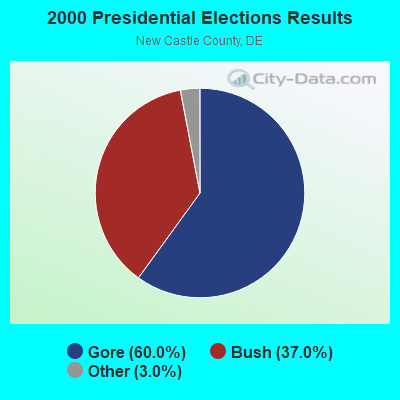
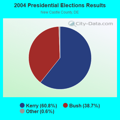
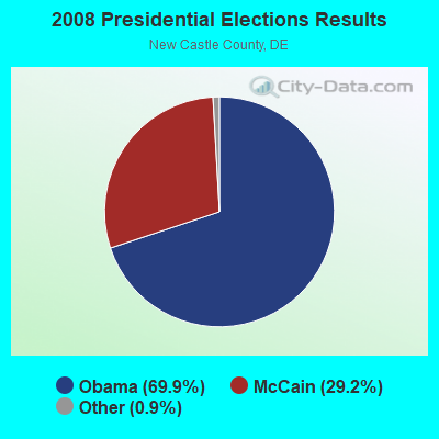
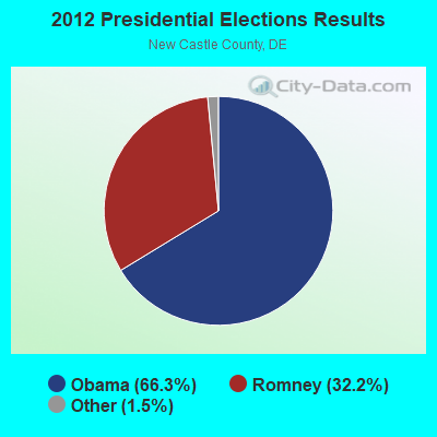
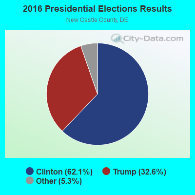
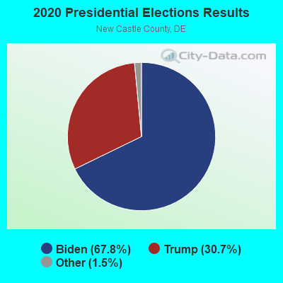
Graphs represent county-level data. Detailed 2008 Election Results
Religion statistics for Lower Christiana, DE (based on New Castle County data)
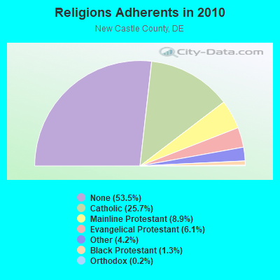
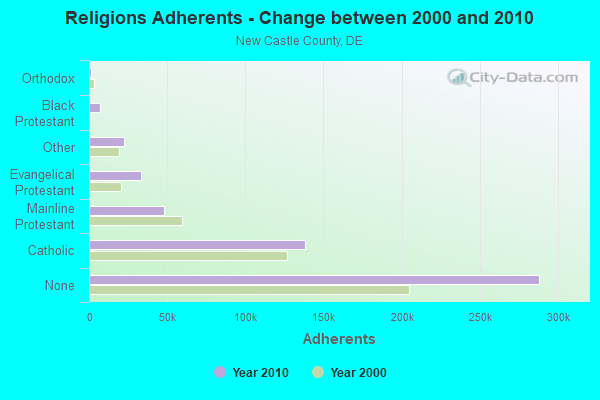
| Religion | Adherents | Congregations |
|---|---|---|
| Catholic | 138,172 | 33 |
| Mainline Protestant | 48,124 | 125 |
| Evangelical Protestant | 32,993 | 169 |
| Other | 22,672 | 45 |
| Black Protestant | 7,212 | 36 |
| Orthodox | 1,166 | 5 |
| None | 288,140 | - |
Food Environment Statistics:
| New Castle County: | 1.56 / 10,000 pop. |
| Delaware: | 1.74 / 10,000 pop. |
| New Castle County: | 0.06 / 10,000 pop. |
| State: | 0.09 / 10,000 pop. |
| New Castle County: | 1.35 / 10,000 pop. |
| Delaware: | 1.25 / 10,000 pop. |
| New Castle County: | 2.13 / 10,000 pop. |
| State: | 2.84 / 10,000 pop. |
| This county: | 6.40 / 10,000 pop. |
| Delaware: | 7.43 / 10,000 pop. |
| New Castle County: | 8.0% |
| Delaware: | 9.0% |
| New Castle County: | 26.7% |
| Delaware: | 27.9% |
5.39% of this county's 2021 resident taxpayers lived in other counties in 2020 ($73,141 average adjusted gross income)
| Here: | 5.39% |
| Delaware average: | 6.79% |
0.01% of residents moved from foreign countries ($80 average AGI)
New Castle County: 0.01% Delaware average: 0.03%
Top counties from which taxpayers relocated into this county between 2020 and 2021:
| from Philadelphia County, PA | |
| from Delaware County, PA | |
| from Kent County, DE |
5.25% of this county's 2020 resident taxpayers moved to other counties in 2021 ($94,385 average adjusted gross income)
| Here: | 5.25% |
| Delaware average: | 5.45% |
0.01% of residents moved to foreign countries ($149 average AGI)
New Castle County: 0.01% Delaware average: 0.03%
Top counties to which taxpayers relocated from this county between 2020 and 2021:
| to Kent County, DE | |
| to Sussex County, DE | |
| to Philadelphia County, PA |
Strongest AM radio stations in Lower Christiana:
- WTMC (1380 AM; 5 kW; WILMINGTON, DE; Owner: STATE OF DELAWARE DEPARTMENT OF TRAN)
- WVCH (740 AM; 50 kW; CHESTER, PA; Owner: WVCH COMMUNICATIONS, INC.)
- WJBR (1290 AM; 2 kW; WILMINGTON, DE; Owner: CAPSTAR TX LIMITED PARTNERSHIP)
- WILM (1450 AM; 1 kW; WILMINGTON, DE; Owner: DELAWARE BROADCASTING CO.)
- WDEL (1150 AM; 5 kW; WILMINGTON, DE; Owner: DELMARVA BROADCASTING COMPANY)
- WPEN (950 AM; 50 kW; PHILADELPHIA, PA; Owner: GREATER PHILADELPHIA RADIO, INC.)
- WZZD (990 AM; 50 kW; PHILADELPHIA, PA; Owner: PENNSYLVANIA MEDIA ASSOCIATES, INC.)
- KYW (1060 AM; 50 kW; PHILADELPHIA, PA; Owner: INFINITY BROADCASTING OPERATIONS, INC.)
- WNWR (1540 AM; 50 kW; PHILADELPHIA, PA)
- WPHT (1210 AM; 50 kW; PHILADELPHIA, PA; Owner: INFINITY BROADCASTING OPERATIONS, INC.)
- WWJZ (640 AM; 50 kW; MOUNT HOLLY, NJ; Owner: ABC, INC.)
- WCBM (680 AM; 50 kW; BALTIMORE, MD; Owner: WCBM MARYLAND, INC.)
- WAMS (1260 AM; 1 kW; NEWARK, DE; Owner: CAPITOL BROADCASTING, INC.)
Strongest FM radio stations in Lower Christiana:
- WSTW (93.7 FM; WILMINGTON, DE; Owner: DELMARVA BROADCASTING COMPANY)
- WJBR-FM (99.5 FM; WILMINGTON, DE; Owner: NM LICENSING, LLC)
- WPLY (100.3 FM; MEDIA, PA; Owner: RADIO ONE LICENSES, LLC)
- WMHS (88.1 FM; PIKE CREEK, DE; Owner: RED CLAY CONSOLIDATED SCHOOL DISTRICT)
- WMPH (91.7 FM; WILMINGTON, DE; Owner: BRANDYWINE SCHOOL DIST, BRD OF EDUC)
- WMGK (102.9 FM; PHILADELPHIA, PA; Owner: GREATER PHILADELPHIA RADIO, INC.)
- WMWX (95.7 FM; PHILADELPHIA, PA; Owner: GREATER PHILADELPHIA RADIO, INC.)
- WOGL (98.1 FM; PHILADELPHIA, PA; Owner: INFINITY BROADCASTING OPERATIONS, INC.)
- WBEB (101.1 FM; PHILADELPHIA, PA; Owner: WEAZ-FM RADIO, INC.)
- WRTI (90.1 FM; PHILADELPHIA, PA; Owner: TEMPLE UNIV. OF THE COMMONWEALTH, ET)
- WSNI-FM (104.5 FM; PHILADELPHIA, PA; Owner: AMFM RADIO LICENSES, L.L.C.)
- WPHI-FM (103.9 FM; JENKINTOWN, PA; Owner: RADIO ONE LICENSES, LLC)
- WMMR (93.3 FM; PHILADELPHIA, PA; Owner: GREATER BOSTON RADIO, INC.)
- WXPN (88.5 FM; PHILADELPHIA, PA; Owner: TRUSTEES OF THE UNIVERSITY OF PENNA.)
- WHYY-FM (90.9 FM; PHILADELPHIA, PA; Owner: WHYY, INC.)
- WXTU (92.5 FM; PHILADELPHIA, PA; Owner: WXTU LICENSE LIMITED PARTNERSHIP)
- WDAS-FM (105.3 FM; PHILADELPHIA, PA; Owner: AMFM RADIO LICENSES, L.L.C.)
- WPTP (96.5 FM; PHILADELPHIA, PA; Owner: WDAS LICENSE LIMITED PARTNERSHIP)
- WYSP (94.1 FM; PHILADELPHIA, PA; Owner: INFINITY BROADCASTING OPERATIONS, INC.)
- W278AK (103.5 FM; VILLAGE GREEN, PA; Owner: PRIORITY RADIO, INC.)
TV broadcast stations around Lower Christiana:
- WTSD-CA (Channel 14; WILMINGTON, DE; Owner: PRIORITY COMMUNICATIONS MINISTRIES, INC.)
- KYW-TV (Channel 3; PHILADELPHIA, PA; Owner: CBS BROADCASTING INC.)
- WPHL-TV (Channel 17; PHILADELPHIA, PA; Owner: TRIBUNE TELEVISION COMPANY)
- WPPX (Channel 61; WILMINGTON, DE; Owner: PAXSON PHILADELPHIA LICENSE, INC.)
- WPVI-TV (Channel 6; PHILADELPHIA, PA; Owner: ABC, INC.)
- WPSG (Channel 57; PHILADELPHIA, PA; Owner: VIACOM STATIONS GROUP OF PHILADELPHIA INC.)
- WCAU (Channel 10; PHILADELPHIA, PA; Owner: NBC SUBSIDIARY (WCAU-TV), L.P.)
- WWJT-LP (Channel 7; PHILADELPHIA, PA; Owner: PHILADELPHIA TELEVISION NETWORK, INC)
- WGTW (Channel 48; BURLINGTON, NJ; Owner: BRUNSON COMMUNICATIONS, INC.)
- W40AZ (Channel 40; WILMINGTON, DE; Owner: NATIONAL MINORITY T.V., INC.)
- W55BT (Channel 55; TALLEYVILLE, DE; Owner: MEDIACASTING LLC)
- WYBE (Channel 35; PHILADELPHIA, PA; Owner: INDEPENDENCE PUBLIC MEDIA OF PHILADELPHIA, INC.)
- WHYY-TV (Channel 12; WILMINGTON, DE; Owner: WHYY, INC.)
- WTXF-TV (Channel 29; PHILADELPHIA, PA; Owner: FOX TV STATIONS OF PHILADELPHIA)
- WMCN-TV (Channel 53; ATLANTIC CITY, NJ; Owner: LENFEST BROADCASTING, LLC)
- WUVP (Channel 65; VINELAND, NJ; Owner: UNIVISION PHILADELPHIA LLC)
- WELL-LP (Channel 8; WILLOW GROVE, ETC., PA; Owner: WORD OF GOD FELLOWSHIP, INC.)
- WNJS (Channel 23; CAMDEN, NJ; Owner: NEW JERSEY PUBLIC BROADCASTING AUTHORITY)
- WFPA-CA (Channel 28; PHILADELPHIA, PA; Owner: WXTV LICENSE PARTNERSHIP, G.P.)
- WPHA-LP (Channel 63; PHILADELPHIA, PA; Owner: COMMERCIAL BROADCASTING CORP.)
- 69.4%Utility gas
- 24.9%Fuel oil, kerosene, etc.
- 4.8%Electricity
- 0.5%Bottled, tank, or LP gas
- 0.3%Other fuel
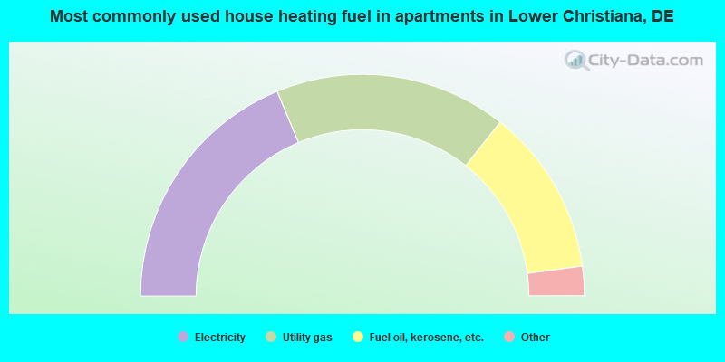
- 37.5%Electricity
- 33.9%Utility gas
- 24.4%Fuel oil, kerosene, etc.
- 3.0%Bottled, tank, or LP gas
- 0.8%Other fuel
- 0.4%No fuel used
Lower Christiana compared to Delaware state average:
- Unemployed percentage significantly below state average.
- Black race population percentage below state average.
- Median age significantly below state average.
- Foreign-born population percentage significantly below state average.
- Length of stay since moving in significantly above state average.
- Number of rooms per house significantly below state average.
- House age significantly below state average.
- Percentage of population with a bachelor's degree or higher below state average.
Lower Christiana on our top lists:
- #29 on the list of "Top 101 cities with the most residents born in United Kingdom (population 500+)"
- #29 on the list of "Top 101 cities with the most residents born in Yugoslavia (population 500+)"
- #29 on the list of "Top 101 cities with the most residents born in Asia, n.e.c. (population 500+)"
- #29 on the list of "Top 101 cities with the most residents born in Melanesia (population 500+)"
- #29 on the list of "Top 101 cities with the most residents born in Micronesia (population 500+)"
- #29 on the list of "Top 101 cities with the most residents born in Polynesia (population 500+)"
- #42 on the list of "Top 101 cities with largest percentage of females in industries: chemicals (population 5,000+)"
- #51 on the list of "Top 101 cities with the most residents born in Other South Eastern Asia (population 500+)"
- #57 on the list of "Top 101 cities with the most residents born in Born at sea (population 500+)"
- #58 on the list of "Top 101 cities with largest percentage of females in industries: finance and insurance (population 5,000+)"
- #67 on the list of "Top 101 cities with largest percentage of males in occupations: occupational and physical therapist assistants and aides (population 5,000+)"
- #69 on the list of "Top 101 cities with largest percentage of females in occupations: electricians (population 5,000+)"
- #73 on the list of "Top 101 cities with largest percentage of females in occupations: customer service representatives (population 5,000+)"
- #78 on the list of "Top 101 cities with largest percentage of males in occupations: electricians (population 5,000+)"
- #78 on the list of "Top 101 cities with largest percentage of males in industries: rail transportation (population 5,000+)"
- #84 on the list of "Top 101 cities with the largest percentage of people in other types of correctional institutions (population 1,000+)"
- #87 on the list of "Top 101 cities with largest percentage of males in occupations: assemblers and fabricators (population 5,000+)"
- #87 on the list of "Top 101 cities with largest percentage of females in occupations: legal support workers (population 5,000+)"
- #93 on the list of "Top 101 cities with largest percentage of females in industries: petroleum and coal products (population 5,000+)"
- #93 on the list of "Top 101 cities with largest percentage of males in industries: sewing, needlework, and piece goods stores (population 5,000+)"
- #17 on the list of "Top 101 counties with the highest number of infant deaths per 1000 residents 2007-2013 (pop. 50,000+)"
- #35 on the list of "Top 101 counties with the highest percentage of residents that visited a dentist within the past year"
- #51 on the list of "Top 101 counties with the highest carbon monoxide air pollution readings in 2012 (ppm)"
- #53 on the list of "Top 101 counties with the highest average weight of females"
- #55 on the list of "Top 101 counties with the highest Nitrogen Dioxide air pollution readings in 2012 (ppm)"