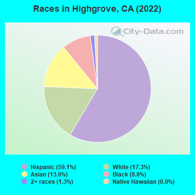
Percentage of residents living in poverty in 2022: 6.5%
(10.6% for White Non-Hispanic residents, 8.9% for Black residents, 4.8% for Hispanic or Latino residents, 4.8% for other race residents, 15.1% for two or more races residents)
Latest news from Highgrove, CA collected exclusively by city-data.com from local newspapers, TV, and radio stations
Ancestries: English (3.8%), Italian (3.1%), German (1.4%).
Current Local Time: PST time zone
Elevation: 949 feet
Land area: 1.10 square miles.
Population density: 3,627 people per square mile (average).
1,558 residents are foreign born (14.9% Latin America, 5.4% Asia).
This place:
21.6%
California:
26.5%
Median real estate property taxes paid for housing units with mortgages in 2022: $7,012 (1.0%) Median real estate property taxes paid for housing units with no mortgage in 2022: $4,481 (0.6%)
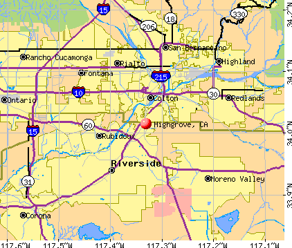
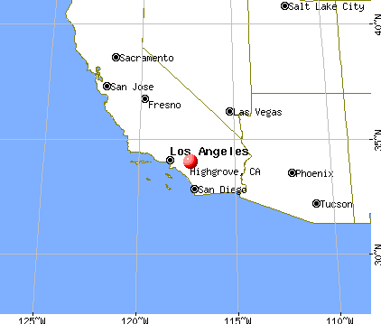
Nearest city with pop. 50,000+: Riverside, CA (6.0 miles , pop. 255,166).
Nearest city with pop. 1,000,000+: Los Angeles, CA (60.1 miles , pop. 3,694,820).
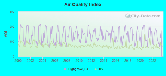
Air Quality Index (AQI) level in 2022 was 133. This is significantly worse than average.
City:
133
U.S.:
73
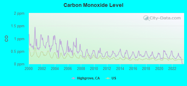
Carbon Monoxide (CO) [ppm] level in 2022 was 0.285. This is about average.Closest monitor was 5.0 miles away from the city center.
City:
0.285
U.S.:
0.251
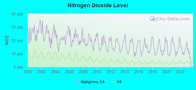
Nitrogen Dioxide (NO2) [ppb] level in 2022 was 13.4. This is significantly worse than average.Closest monitor was 4.7 miles away from the city center.
City:
13.4
U.S.:
5.1
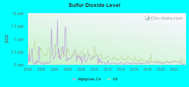
Sulfur Dioxide (SO2) [ppb] level in 2022 was 0.525. This is significantly better than average.Closest monitor was 5.0 miles away from the city center.
City:
0.525
U.S.:
1.515
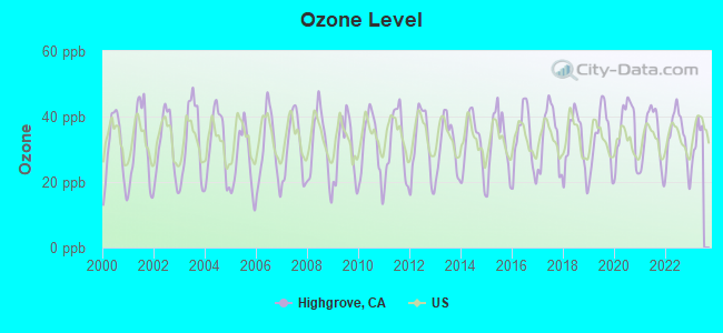
Ozone [ppb] level in 2022 was 33.9. This is about average.Closest monitor was 4.7 miles away from the city center.
City:
33.9
U.S.:
33.3
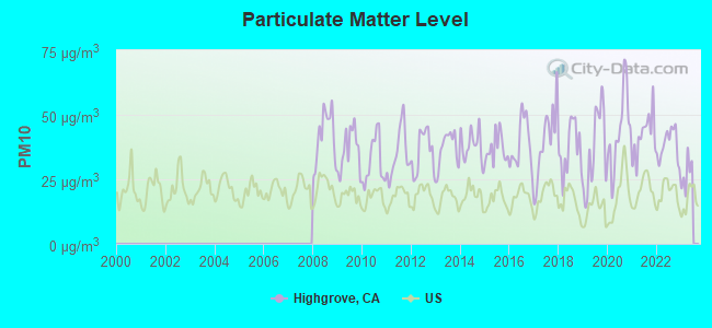
Particulate Matter (PM10) [µg/m3] level in 2022 was 38.2. This is significantly worse than average.Closest monitor was 5.0 miles away from the city center.
City:
38.2
U.S.:
19.2
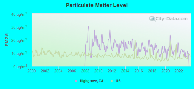
Particulate Matter (PM2.5) [µg/m3] level in 2022 was 10.6. This is worse than average.Closest monitor was 5.0 miles away from the city center.
City:
10.6
U.S.:
8.1
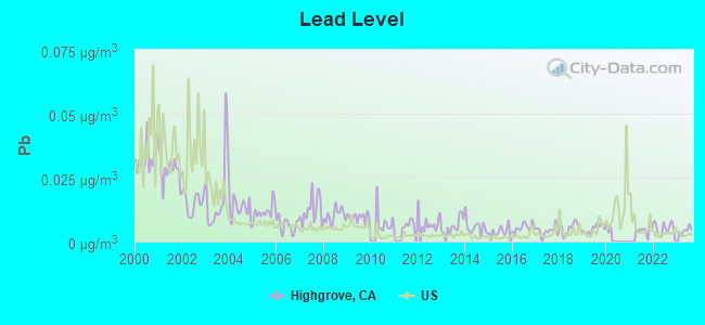
Lead (Pb) [µg/m3] level in 2023 was 0.00426. This is significantly better than average.Closest monitor was 5.0 miles away from the city center.
City:
0.00426
U.S.:
0.00931
Earthquake activity:
Highgrove-area historical earthquake activity is significantly above California state average. It is 7294% greater than the overall U.S. average.
On 6/28/1992 at 11:57:34, a magnitude 7.6 (6.2 MB, 7.6 MS, 7.3 MW, Depth: 0.7 mi, Class: Major, Intensity: VIII - XII) earthquake occurred 47.2 miles away from Highgrove center, causing 3 deaths (1 shaking deaths, 2 other deaths) and 400 injuries, causing $100,000,000 total damage and $40,000,000 insured losses On 7/21/1952 at 11:52:14, a magnitude 7.7 (7.7 UK) earthquake occurred 117.0 miles away from the city center, causing $50,000,000 total damage On 10/16/1999 at 09:46:44, a magnitude 7.4 (6.3 MB, 7.4 MS, 7.2 MW, 7.3 ML) earthquake occurred 61.8 miles away from the city center On 5/19/1940 at 04:36:40, a magnitude 7.2 (7.2 UK) earthquake occurred 108.9 miles away from Highgrove center, causing $33,000,000 total damage On 6/28/1992 at 15:05:30, a magnitude 6.9 (6.3 MB, 6.7 MS, 6.5 MW, 6.9 ME, Depth: 3.1 mi, Class: Strong, Intensity: VII - IX) earthquake occurred 35.0 miles away from Highgrove center On 4/21/1918 at 22:32:30, a magnitude 6.8 (6.8 UK) earthquake occurred 15.4 miles away from the city center Magnitude types: body-wave magnitude (MB), energy magnitude (ME), local magnitude (ML), surface-wave magnitude (MS), moment magnitude (MW)
Natural disasters:
The number of natural disasters in Riverside County (46) is a lot greater than the US average (15). Major Disasters (Presidential) Declared: 27 Emergencies Declared: 1
Causes of natural disasters: Fires: 22, Floods: 20, Storms: 8, Winter Storms: 8, Landslides: 6, Mudslides: 5, Heavy Rains: 2, Earthquake: 1, Flash Flood: 1, Freeze: 1, Hurricane: 1, Tornado: 1, Tropical Storm: 1, Other: 1 (Note: some incidents may be assigned to more than one category).
Hospitals and medical centers near Highgrove:
PATHWAYS TO CARE HOME HEALTH (Home Health Center, about 2 miles away; RIVERSIDE, CA)
HEARTLAND HOME HEALTH CARE AND HOSPICE (Home Health Center, about 2 miles away; RIVERSIDE, CA)
TENDER LOVING CARE (Home Health Center, about 2 miles away; RIVERSIDE, CA)
ST. ANTHONY'S HOME CARE, INC. (Home Health Center, about 2 miles away; GRAND TERRACE, CA)
ADDUS HEALTHCARE, INC (Home Health Center, about 2 miles away; RIVERSIDE, CA)
CANAL DIVISION (Hospital, about 2 miles away; GRAND TERRACE, CA)
OPTIMA HOME HEALTH SERVICES (Home Health Center, about 2 miles away; RIVERSIDE, CA)
Amtrak stations near Highgrove:
4 miles: RIVERSIDE (4066 VINE ST.) - Bus Station . Services: fully wheelchair accessible, public payphones, full-service food facilities, free short-term parking, free long-term parking, call for car rental service, call for taxi service, public transit connection.
7 miles: SAN BERNADINO (SAN BERNARDINO, 1170 W. 3RD ST.) . Services: ticket office, partially wheelchair accessible, public payphones, free short-term parking, free long-term parking.
8 miles: MORENO VALLEY (ARCO MINI MART, 2624 E. ALESSANDRO BLVD.) - Bus Station . Services: public payphones.
Colleges/universities with over 2000 students nearest to Highgrove:
University of California-Riverside (about 3 miles; Riverside, CA; Full-time enrollment: 20,647)
Riverside City College (about 5 miles; Riverside, CA; FT enrollment: 10,661)
Loma Linda University (about 5 miles; Loma Linda, CA; FT enrollment: 2,839)
San Bernardino Valley College (about 6 miles; San Bernardino, CA; FT enrollment: 7,444)
The Art Institute of California-Argosy University Inland Empire (about 6 miles; San Bernardino, CA; FT enrollment: 2,238)
California Baptist University (about 9 miles; Riverside, CA; FT enrollment: 6,085)
University of Redlands (about 11 miles; Redlands, CA; FT enrollment: 4,854)
User-submitted facts and corrections:
The Riverside campus of the University of California (UCR)is the nearest college campus to Highgrove. that campus has grown in the past decade to over 7,000 students. The Highgrove library is run by Riverside County, no longer affiliated with the City of Riverside. The branch has 4 computer stations, with internet access, but no running water or toilet facilities for patrons or employees.
Notable locations in Highgrove: Highgrove Branch Riverside City and County Public Library (A), Riverside County Fire Department Station 19 Highgrove (B). Display/hide their locations on the map
Churches in Highgrove include: Highgrove United Methodist Church (A), Immanuel Baptist Temple (B), Kingdom Hall of Jehovahs Witnesses (C), Unity Church (D). Display/hide their locations on the map
Riverside County has a predicted average indoor radon screening level between 2 and 4 pCi/L (pico curies per liter) - Moderate Potential
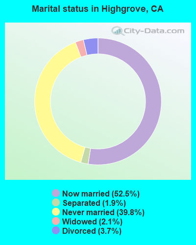
Average household size:
This place:
3.5 people
California:
2.9 people
Percentage of family households:
This place:
79.2%
Whole state:
68.7%
Percentage of households with unmarried partners:
This place:
9.4%
Whole state:
7.2%
Likely homosexual households (counted as self-reported same-sex unmarried-partner households)
Lesbian couples: 0.3% of all households
Gay men: 0.3% of all households
6 people in group homes intended for adults in 2010
6 people in other group homes in 2000
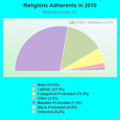
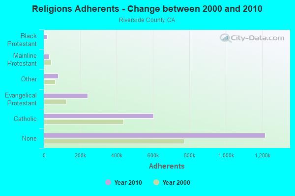
Religion statistics for Highgrove, CA (based on Riverside County data)
Religion
Adherents
Congregations
Catholic
602,765
51
Evangelical Protestant
240,306
741
Other
77,581
194
Mainline Protestant
29,535
103
Black Protestant
19,170
40
Orthodox
3,647
11
None
1,216,637
-
Source: Clifford Grammich, Kirk Hadaway, Richard Houseal, Dale E.Jones, Alexei Krindatch, Richie Stanley and Richard H.Taylor. 2012. 2010 U.S.Religion Census: Religious Congregations & Membership Study. Association of Statisticians of American Religious Bodies. Jones, Dale E., et al. 2002. Congregations and Membership in the United States 2000. Nashville, TN: Glenmary Research Center. Graphs represent county-level data
HIGHGROVECDF, 469 Center St (Lat: 34.016056 Lon: -117.321028), Type: Building, Structure height: 5.2 m, Overall height: 6.4 m, Call Sign: KVY39, Assigned Frequencies: 159.285 MHz, 159.360 MHz, Grant Date: 01/13/2021, Expiration Date: 04/08/2031, Registrant: State Of California, 601 Sequoia Pacific Blvd, Sacramento, CA 95811-0231, Phone: (916) 894-5102, Fax: (916) 894-5392, Email:
Bnsf Row 6.8 Mi N (Lat: 34.025306 Lon: -117.333389), Type: Building, Structure height: 3 m, Overall height: 5 m, Call Sign: WNJW828, Assigned Frequencies: 160.650 MHz, 161.190 MHz, Grant Date: 04/17/2004, Expiration Date: 04/18/2014, Cancellation Date: 03/18/2013, Certifier: Robert C Leedham, Registrant: Bnsf Railway Co., 4515 Kansas Ave, Kansas City, KS 66106, Phone: (913) 551-4640, Fax: (913) 551-4053, Email:
FCC Registered Microwave Towers:
1
Box Springs, CA, Box Springs Mountain 5.3 Km Sse Of Highgrove, Ca (Lat: 33.966417 Lon: -117.288667), Type: Ltower, Structure height: 47 m, Call Sign: WQZG493, Assigned Frequencies: 944.500 MHz, Grant Date: 05/09/2017, Expiration Date: 12/01/2021, Cancellation Date: 11/16/2018, Certifier: Jo Ann Haller, Registrant: Entercom Communications Corp., 401 E. City Ave, Suite 809, Bala Cynwyd, PA 19004, Phone: (610) 660-5610, Email:
FCC Registered Amateur Radio Licenses:
2
Call Sign: W6TIR, Grant Date: 08/04/1992, Expiration Date: 08/04/2002, Cancellation Date: 08/05/2004, Registrant: Eldon E Jory, 440 Pacific Ave, Highgrove, CA 92507
Call Sign: KK6PXX, Licensee ID: L01903258, Grant Date: 11/07/2014, Expiration Date: 11/07/2024, Certifier: Tony A Troncoso, Registrant: Tony A Troncoso, 468 Trabert, Highgrove, CA 92507
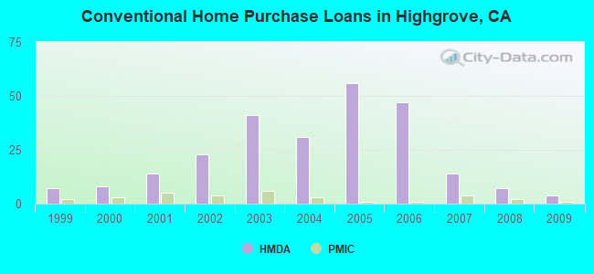
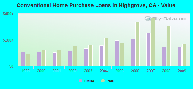
Home Mortgage Disclosure Act Aggregated Statistics For Year 2009 (Based on 1 partial tract)
A) FHA, FSA/RHS & VA Home Purchase Loans
B) Conventional Home Purchase Loans
C) Refinancings
D) Home Improvement Loans
F) Non-occupant Loans on < 5 Family Dwellings (A B C & D)
Number
Average Value
Number
Average Value
Number
Average Value
Number
Average Value
Number
Average Value
LOANS ORIGINATED
9
$158,468
4
$150,040
8
$180,269
0
$0
2
$90,685
APPLICATIONS APPROVED, NOT ACCEPTED
0
$0
0
$0
1
$288,540
1
$64,850
0
$0
APPLICATIONS DENIED
2
$126,410
1
$148,670
8
$212,420
2
$21,160
1
$110,190
APPLICATIONS WITHDRAWN
1
$197,580
1
$206,920
2
$157,460
0
$0
1
$125,580
FILES CLOSED FOR INCOMPLETENESS
1
$138,770
1
$133,550
2
$182,880
0
$0
0
$0
Aggregated Statistics For Year 2008 (Based on 1 partial tract)
A) FHA, FSA/RHS & VA Home Purchase Loans
B) Conventional Home Purchase Loans
C) Refinancings
D) Home Improvement Loans
E) Loans on Dwellings For 5+ Families
F) Non-occupant Loans on < 5 Family Dwellings (A B C & D)
G) Loans On Manufactured Home Dwelling (A B C & D)
Number
Average Value
Number
Average Value
Number
Average Value
Number
Average Value
Number
Average Value
Number
Average Value
Number
Average Value
LOANS ORIGINATED
6
$200,420
7
$148,784
11
$188,488
1
$139,600
0
$0
4
$135,132
0
$0
APPLICATIONS APPROVED, NOT ACCEPTED
0
$0
3
$182,560
3
$225,703
1
$71,450
0
$0
1
$256,390
1
$23,360
APPLICATIONS DENIED
1
$175,870
3
$177,063
17
$213,843
2
$119,815
1
$214,340
1
$236,880
0
$0
APPLICATIONS WITHDRAWN
1
$390,490
2
$213,520
6
$210,908
1
$140,970
0
$0
0
$0
0
$0
FILES CLOSED FOR INCOMPLETENESS
0
$0
0
$0
1
$153,890
0
$0
0
$0
0
$0
0
$0
Aggregated Statistics For Year 2007 (Based on 1 partial tract)
A) FHA, FSA/RHS & VA Home Purchase Loans
B) Conventional Home Purchase Loans
C) Refinancings
D) Home Improvement Loans
F) Non-occupant Loans on < 5 Family Dwellings (A B C & D)
G) Loans On Manufactured Home Dwelling (A B C & D)
Number
Average Value
Number
Average Value
Number
Average Value
Number
Average Value
Number
Average Value
Number
Average Value
LOANS ORIGINATED
1
$149,490
14
$253,032
48
$226,160
7
$104,346
9
$208,084
0
$0
APPLICATIONS APPROVED, NOT ACCEPTED
0
$0
4
$175,802
14
$261,747
1
$253,640
1
$389,390
1
$73,370
APPLICATIONS DENIED
0
$0
11
$229,883
41
$255,504
13
$181,896
6
$234,725
1
$108,000
APPLICATIONS WITHDRAWN
0
$0
4
$240,862
12
$241,617
2
$176,145
2
$219,705
0
$0
FILES CLOSED FOR INCOMPLETENESS
0
$0
2
$314,920
8
$254,946
2
$198,955
1
$91,230
0
$0
Aggregated Statistics For Year 2006 (Based on 1 partial tract)
B) Conventional Home Purchase Loans
C) Refinancings
D) Home Improvement Loans
E) Loans on Dwellings For 5+ Families
F) Non-occupant Loans on < 5 Family Dwellings (A B C & D)
Number
Average Value
Number
Average Value
Number
Average Value
Number
Average Value
Number
Average Value
LOANS ORIGINATED
47
$207,813
64
$225,469
12
$156,452
1
$722,720
14
$192,478
APPLICATIONS APPROVED, NOT ACCEPTED
18
$210,008
15
$245,506
3
$160,117
0
$0
4
$173,262
APPLICATIONS DENIED
32
$214,061
34
$243,085
10
$198,268
0
$0
5
$214,290
APPLICATIONS WITHDRAWN
13
$236,434
28
$232,912
4
$125,995
0
$0
4
$169,070
FILES CLOSED FOR INCOMPLETENESS
3
$240,177
5
$206,594
0
$0
0
$0
0
$0
Aggregated Statistics For Year 2005 (Based on 1 partial tract)
B) Conventional Home Purchase Loans
C) Refinancings
D) Home Improvement Loans
E) Loans on Dwellings For 5+ Families
F) Non-occupant Loans on < 5 Family Dwellings (A B C & D)
G) Loans On Manufactured Home Dwelling (A B C & D)
Number
Average Value
Number
Average Value
Number
Average Value
Number
Average Value
Number
Average Value
Number
Average Value
LOANS ORIGINATED
56
$196,089
81
$203,878
11
$152,714
1
$360,540
12
$179,902
0
$0
APPLICATIONS APPROVED, NOT ACCEPTED
11
$165,779
18
$185,459
1
$126,680
0
$0
2
$168,450
1
$66,780
APPLICATIONS DENIED
25
$197,174
36
$227,786
5
$98,928
1
$319,590
8
$200,329
1
$262,160
APPLICATIONS WITHDRAWN
15
$191,957
28
$213,196
2
$121,185
0
$0
4
$121,118
0
$0
FILES CLOSED FOR INCOMPLETENESS
2
$170,650
8
$232,721
1
$37,100
0
$0
0
$0
0
$0
Aggregated Statistics For Year 2004 (Based on 1 partial tract)
A) FHA, FSA/RHS & VA Home Purchase Loans
B) Conventional Home Purchase Loans
C) Refinancings
D) Home Improvement Loans
E) Loans on Dwellings For 5+ Families
F) Non-occupant Loans on < 5 Family Dwellings (A B C & D)
G) Loans On Manufactured Home Dwelling (A B C & D)
Number
Average Value
Number
Average Value
Number
Average Value
Number
Average Value
Number
Average Value
Number
Average Value
Number
Average Value
LOANS ORIGINATED
1
$179,720
31
$158,710
82
$161,442
12
$102,134
1
$201,980
15
$130,731
0
$0
APPLICATIONS APPROVED, NOT ACCEPTED
0
$0
10
$153,970
15
$160,117
2
$141,520
0
$0
1
$253,090
0
$0
APPLICATIONS DENIED
0
$0
10
$130,173
34
$160,281
9
$84,211
0
$0
5
$114,756
1
$77,220
APPLICATIONS WITHDRAWN
0
$0
12
$147,728
23
$142,741
2
$111,705
1
$1,064,300
2
$131,215
0
$0
FILES CLOSED FOR INCOMPLETENESS
0
$0
1
$184,670
8
$174,326
1
$94,260
0
$0
0
$0
0
$0
Aggregated Statistics For Year 2003 (Based on 1 partial tract)
A) FHA, FSA/RHS & VA Home Purchase Loans
B) Conventional Home Purchase Loans
C) Refinancings
D) Home Improvement Loans
F) Non-occupant Loans on < 5 Family Dwellings (A B C & D)
Number
Average Value
Number
Average Value
Number
Average Value
Number
Average Value
Number
Average Value
LOANS ORIGINATED
4
$153,132
41
$135,021
108
$123,724
5
$49,958
12
$94,600
APPLICATIONS APPROVED, NOT ACCEPTED
0
$0
6
$175,643
19
$126,625
1
$29,130
2
$129,845
APPLICATIONS DENIED
1
$121,190
13
$142,198
40
$123,323
5
$28,030
5
$103,214
APPLICATIONS WITHDRAWN
1
$128,330
3
$124,393
29
$120,050
1
$43,970
1
$145,640
FILES CLOSED FOR INCOMPLETENESS
0
$0
0
$0
7
$130,766
1
$67,600
1
$45,890
Aggregated Statistics For Year 2002 (Based on 1 partial tract)
A) FHA, FSA/RHS & VA Home Purchase Loans
B) Conventional Home Purchase Loans
C) Refinancings
D) Home Improvement Loans
E) Loans on Dwellings For 5+ Families
F) Non-occupant Loans on < 5 Family Dwellings (A B C & D)
Number
Average Value
Number
Average Value
Number
Average Value
Number
Average Value
Number
Average Value
Number
Average Value
LOANS ORIGINATED
10
$125,666
23
$114,867
64
$109,370
5
$17,808
1
$307,780
7
$83,657
APPLICATIONS APPROVED, NOT ACCEPTED
0
$0
6
$103,187
15
$102,702
1
$20,340
0
$0
1
$97,280
APPLICATIONS DENIED
2
$95,630
6
$125,675
21
$105,667
4
$14,565
1
$132,450
2
$95,220
APPLICATIONS WITHDRAWN
2
$148,255
7
$102,776
20
$116,872
1
$51,110
0
$0
1
$95,080
FILES CLOSED FOR INCOMPLETENESS
0
$0
1
$38,470
7
$127,743
0
$0
0
$0
0
$0
Aggregated Statistics For Year 2001 (Based on 1 partial tract)
A) FHA, FSA/RHS & VA Home Purchase Loans
B) Conventional Home Purchase Loans
C) Refinancings
D) Home Improvement Loans
E) Loans on Dwellings For 5+ Families
F) Non-occupant Loans on < 5 Family Dwellings (A B C & D)
Number
Average Value
Number
Average Value
Number
Average Value
Number
Average Value
Number
Average Value
Number
Average Value
LOANS ORIGINATED
10
$126,600
14
$106,642
40
$101,621
3
$19,237
1
$333,060
5
$91,178
APPLICATIONS APPROVED, NOT ACCEPTED
2
$115,005
2
$86,285
6
$99,523
1
$17,590
0
$0
1
$74,750
APPLICATIONS DENIED
1
$95,360
5
$66,392
22
$92,408
4
$19,648
0
$0
3
$83,540
APPLICATIONS WITHDRAWN
2
$104,425
3
$115,233
12
$99,547
2
$40,260
0
$0
1
$70,900
FILES CLOSED FOR INCOMPLETENESS
1
$86,010
2
$106,620
3
$93,340
0
$0
0
$0
0
$0
Aggregated Statistics For Year 2000 (Based on 1 partial tract)
A) FHA, FSA/RHS & VA Home Purchase Loans
B) Conventional Home Purchase Loans
C) Refinancings
D) Home Improvement Loans
F) Non-occupant Loans on < 5 Family Dwellings (A B C & D)
Number
Average Value
Number
Average Value
Number
Average Value
Number
Average Value
Number
Average Value
LOANS ORIGINATED
16
$109,078
8
$109,164
12
$60,433
2
$22,535
2
$88,625
APPLICATIONS APPROVED, NOT ACCEPTED
2
$68,835
1
$118,710
3
$68,243
2
$21,985
1
$46,720
APPLICATIONS DENIED
1
$116,790
3
$51,113
10
$109,343
6
$24,687
1
$127,230
APPLICATIONS WITHDRAWN
2
$140,970
2
$68,150
5
$60,620
0
$0
0
$0
FILES CLOSED FOR INCOMPLETENESS
1
$72,000
1
$20,340
2
$87,110
0
$0
1
$46,440
Aggregated Statistics For Year 1999 (Based on 1 partial tract)
A) FHA, FSA/RHS & VA Home Purchase Loans
B) Conventional Home Purchase Loans
C) Refinancings
D) Home Improvement Loans
F) Non-occupant Loans on < 5 Family Dwellings (A B C & D)


 Recent articles from our blog. Our writers, many of them Ph.D. graduates or candidates, create easy-to-read articles on a wide variety of topics.

 (6.0 miles