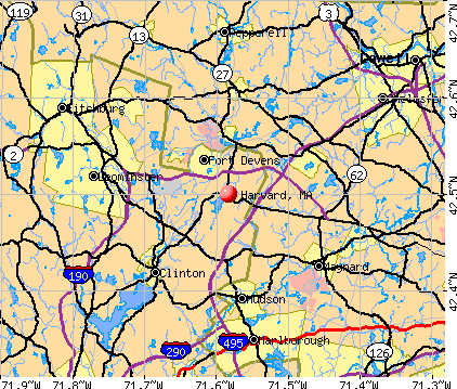
Harvard, Massachusetts
Submit your own pictures of this town and show them to the world
- OSM Map
- General Map
- Google Map
- MSN Map
Population change since 2000: +9.0%
 |
| Males: 3,779 | |
| Females: 2,741 |
| Median resident age: | 42.8 years |
| Massachusetts median age: | 39.2 years |
Zip codes: 01451.
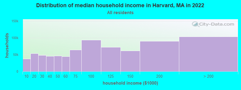
| Harvard: | $194,472 |
| MA: | $94,488 |
Estimated per capita income in 2022: $79,682 (it was $40,867 in 2000)
Harvard town income, earnings, and wages data
Estimated median house or condo value in 2022: over $1,000,000 (it was $369,900 in 2000)
| Harvard: | over $1,000,000 |
| MA: | $534,700 |
Mean prices in 2022: all housing units: $419,164; detached houses: $447,621; townhouses or other attached units: $343,592; in 2-unit structures: $323,295; in 3-to-4-unit structures: $332,295; in 5-or-more-unit structures: $232,758; mobile homes: $113,885
Detailed information about poverty and poor residents in Harvard, MA


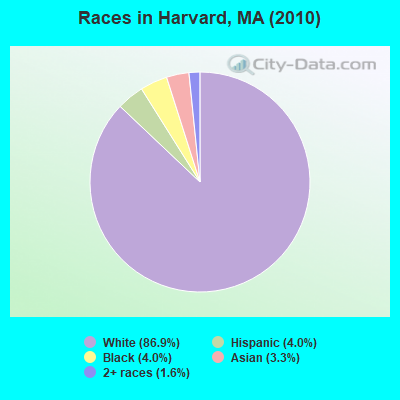
- 5,66886.9%White alone
- 2594.0%Black alone
- 2644.0%Hispanic
- 2173.3%Asian alone
- 1061.6%Two or more races
- 30.05%Native Hawaiian and Other
Pacific Islander alone - 20.03%Other race alone
- 10.02%American Indian alone
Races in Harvard detailed stats: ancestries, foreign born residents, place of birth
Type |
2009 |
2010 |
2011 |
2012 |
2013 |
2014 |
2015 |
2016 |
2017 |
2018 |
2019 |
2020 |
2021 |
2022 |
|---|---|---|---|---|---|---|---|---|---|---|---|---|---|---|
| Murders (per 100,000) | 0 (0.0) | 0 (0.0) | 0 (0.0) | 0 (0.0) | 0 (0.0) | 0 (0.0) | 0 (0.0) | 0 (0.0) | 0 (0.0) | 0 (0.0) | 0 (0.0) | 0 (0.0) | 0 (0.0) | 1 (14.6) |
| Rapes (per 100,000) | 1 (16.5) | 0 (0.0) | 0 (0.0) | 1 (15.2) | 2 (30.5) | 2 (30.3) | 0 (0.0) | 2 (30.5) | 0 (0.0) | 1 (15.2) | 3 (45.7) | 0 (0.0) | 5 (74.8) | 1 (14.6) |
| Robberies (per 100,000) | 0 (0.0) | 0 (0.0) | 0 (0.0) | 0 (0.0) | 0 (0.0) | 1 (15.2) | 0 (0.0) | 0 (0.0) | 0 (0.0) | 0 (0.0) | 0 (0.0) | 0 (0.0) | 0 (0.0) | 0 (0.0) |
| Assaults (per 100,000) | 1 (16.5) | 3 (46.0) | 3 (45.7) | 2 (30.3) | 2 (30.5) | 3 (45.5) | 3 (45.6) | 7 (106.8) | 1 (15.2) | 3 (45.6) | 2 (30.4) | 0 (0.0) | 3 (44.9) | 8 (116.4) |
| Burglaries (per 100,000) | 17 (281.2) | 27 (414.1) | 20 (304.9) | 32 (485.2) | 23 (351.3) | 17 (257.7) | 10 (152.0) | 14 (213.7) | 11 (167.4) | 8 (121.7) | 6 (91.3) | 8 (121.3) | 6 (89.8) | 4 (58.2) |
| Thefts (per 100,000) | 29 (479.7) | 38 (582.8) | 28 (426.8) | 18 (272.9) | 14 (213.8) | 25 (379.0) | 13 (197.7) | 23 (351.0) | 16 (243.5) | 69 (1,050) | 20 (304.5) | 14 (212.3) | 12 (179.6) | 9 (131.0) |
| Auto thefts (per 100,000) | 0 (0.0) | 1 (15.3) | 0 (0.0) | 0 (0.0) | 0 (0.0) | 1 (15.2) | 2 (30.4) | 0 (0.0) | 0 (0.0) | 0 (0.0) | 0 (0.0) | 2 (30.3) | 1 (15.0) | 0 (0.0) |
| Arson (per 100,000) | 2 (33.1) | 0 (0.0) | 3 (45.7) | 0 (0.0) | 3 (45.8) | 1 (15.2) | 4 (60.8) | 1 (15.3) | 0 (0.0) | 1 (15.2) | 0 (0.0) | 0 (0.0) | 0 (0.0) | 0 (0.0) |
| City-Data.com crime index | 55.4 | 62.7 | 47.6 | 63.1 | 63.7 | 72.3 | 30.1 | 74.8 | 24.5 | 71.8 | 61.2 | 19.4 | 83.5 | 73.4 |
The City-Data.com crime index weighs serious crimes and violent crimes more heavily. Higher means more crime, U.S. average is 246.1. It adjusts for the number of visitors and daily workers commuting into cities.
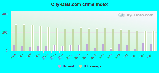
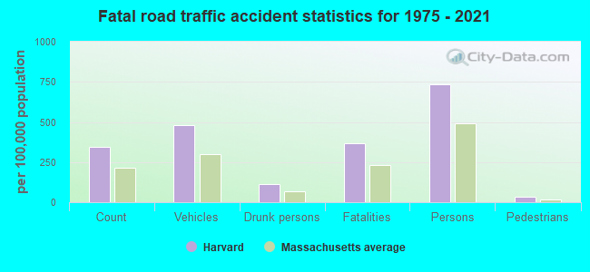
Crime rate in Harvard detailed stats: murders, rapes, robberies, assaults, burglaries, thefts, arson
Full-time law enforcement employees in 2015, including police officers: 10 (8 officers - 7 male; 1 female).
| Officers per 1,000 residents here: | 1.22 |
| Massachusetts average: | 2.54 |
 Recent articles from our blog. Our writers, many of them Ph.D. graduates or candidates, create easy-to-read articles on a wide variety of topics.


Latest news from Harvard, MA collected exclusively by city-data.com from local newspapers, TV, and radio stations
Harvard, MA City Guides:
Ancestries: English (20.3%), Irish (18.2%), German (11.4%), Italian (6.7%), United States (5.3%), Polish (4.5%).
Current Local Time: EST time zone
Incorporated in 1732
Elevation: 421 feet
Land area: 26.4 square miles.
Population density: 247 people per square mile (very low).
748 residents are foreign born (6.6% Latin America, 3.2% Europe, 1.8% Asia).
| This town: | 12.5% |
| Massachusetts: | 12.2% |
| Harvard town: | 1.1% ($4,208) |
| Massachusetts: | 1.3% ($2,336) |
Nearest city with pop. 50,000+: Lowell, MA  (16.7 miles , pop. 105,167).
Nearest city with pop. 200,000+: Boston, MA (29.2 miles , pop. 589,141).
Nearest city with pop. 1,000,000+: Bronx, NY (164.9 miles , pop. 1,332,650).
Nearest cities:
), ), ), ), Latitude: 42.52 N, Longitude: 71.60 W
Area code: 978

Harvard, Massachusetts accommodation & food services, waste management - Economy and Business Data
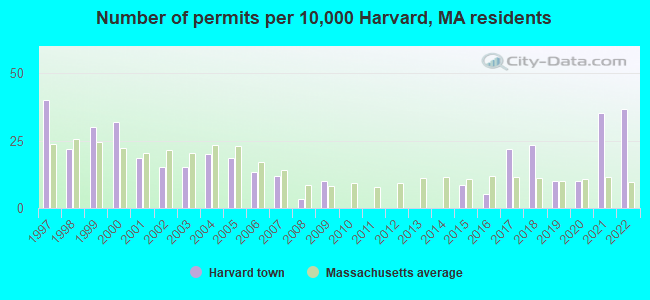
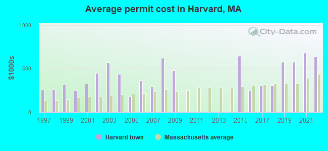
Single-family new house construction building permits:
- 2022: 22 buildings, average cost: $642,200
- 2021: 21 buildings, average cost: $681,000
- 2020: 6 buildings, average cost: $575,300
- 2019: 6 buildings, average cost: $575,300
- 2018: 14 buildings, average cost: $304,300
- 2017: 13 buildings, average cost: $304,300
- 2016: 3 buildings, average cost: $246,900
- 2015: 5 buildings, average cost: $645,000
- 2009: 6 buildings, average cost: $479,200
- 2008: 2 buildings, average cost: $625,000
- 2007: 7 buildings, average cost: $294,600
- 2006: 8 buildings, average cost: $361,300
- 2005: 11 buildings, average cost: $177,500
- 2004: 12 buildings, average cost: $438,700
- 2003: 9 buildings, average cost: $570,300
- 2002: 9 buildings, average cost: $452,800
- 2001: 11 buildings, average cost: $332,600
- 2000: 19 buildings, average cost: $247,600
- 1999: 18 buildings, average cost: $320,900
- 1998: 13 buildings, average cost: $262,100
- 1997: 24 buildings, average cost: $257,200
| Here: | 2.8% |
| Massachusetts: | 3.5% |
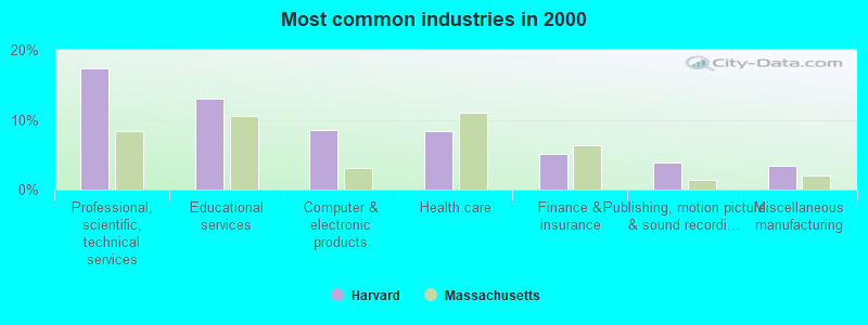
- Professional, scientific, technical services (17.4%)
- Educational services (13.1%)
- Computer & electronic products (8.5%)
- Health care (8.4%)
- Finance & insurance (5.1%)
- Publishing, motion picture & sound recording industries (3.9%)
- Miscellaneous manufacturing (3.4%)
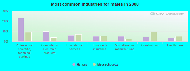
- Professional, scientific, technical services (23.0%)
- Computer & electronic products (9.9%)
- Educational services (6.0%)
- Finance & insurance (5.1%)
- Miscellaneous manufacturing (5.1%)
- Construction (4.7%)
- Health care (3.7%)
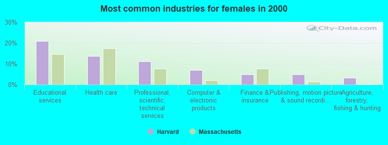
- Educational services (21.0%)
- Health care (13.8%)
- Professional, scientific, technical services (11.2%)
- Computer & electronic products (7.0%)
- Finance & insurance (5.0%)
- Publishing, motion picture & sound recording industries (4.8%)
- Agriculture, forestry, fishing & hunting (3.4%)
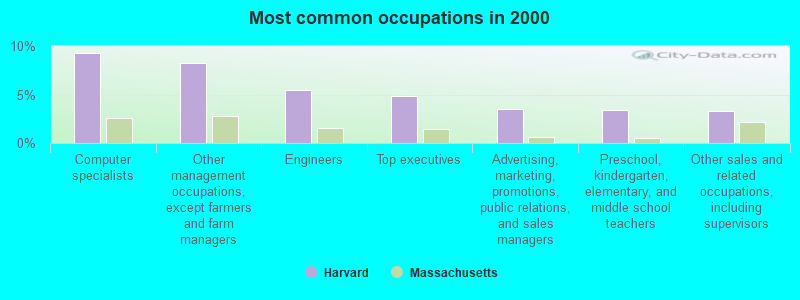
- Computer specialists (9.3%)
- Other management occupations, except farmers and farm managers (8.2%)
- Engineers (5.4%)
- Top executives (4.9%)
- Advertising, marketing, promotions, public relations, and sales managers (3.5%)
- Preschool, kindergarten, elementary, and middle school teachers (3.4%)
- Other sales and related occupations, including supervisors (3.3%)
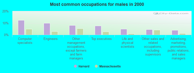
- Computer specialists (12.4%)
- Engineers (9.9%)
- Other management occupations, except farmers and farm managers (8.1%)
- Top executives (7.6%)
- Life and physical scientists (4.9%)
- Other sales and related occupations, including supervisors (4.5%)
- Advertising, marketing, promotions, public relations, and sales managers (3.9%)
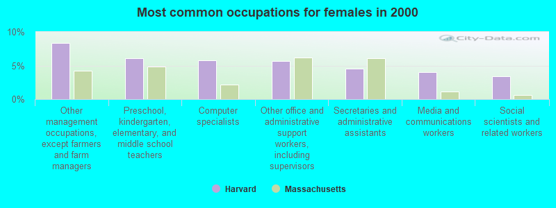
- Other management occupations, except farmers and farm managers (8.4%)
- Preschool, kindergarten, elementary, and middle school teachers (6.1%)
- Computer specialists (5.8%)
- Other office and administrative support workers, including supervisors (5.7%)
- Secretaries and administrative assistants (4.5%)
- Media and communications workers (4.0%)
- Social scientists and related workers (3.5%)
Average climate in Harvard, Massachusetts
Based on data reported by over 4,000 weather stations


(lower is better)
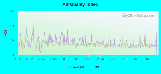
Air Quality Index (AQI) level in 2022 was 63.3. This is about average.
| City: | 63.3 |
| U.S.: | 72.6 |
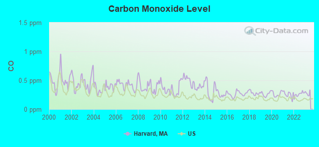
Carbon Monoxide (CO) [ppm] level in 2022 was 0.259. This is about average. Closest monitor was 17.0 miles away from the city center.
| City: | 0.259 |
| U.S.: | 0.251 |
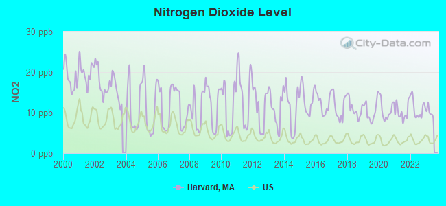
Nitrogen Dioxide (NO2) [ppb] level in 2022 was 11.0. This is significantly worse than average. Closest monitor was 3.1 miles away from the city center.
| City: | 11.0 |
| U.S.: | 5.1 |
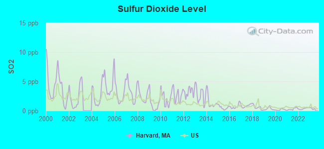
Sulfur Dioxide (SO2) [ppb] level in 2022 was 0.370. This is significantly better than average. Closest monitor was 3.1 miles away from the city center.
| City: | 0.370 |
| U.S.: | 1.515 |
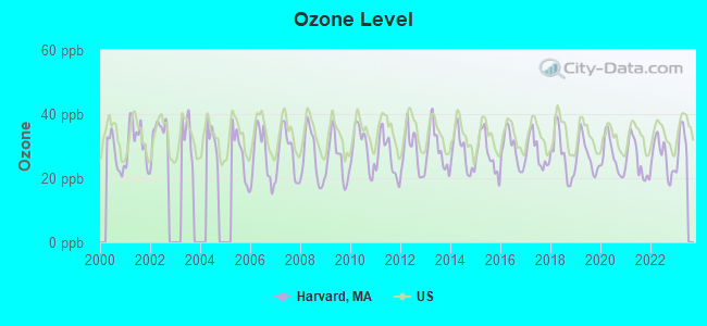
Ozone [ppb] level in 2022 was 26.5. This is better than average. Closest monitor was 10.1 miles away from the city center.
| City: | 26.5 |
| U.S.: | 33.3 |
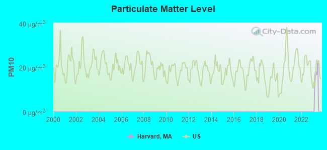
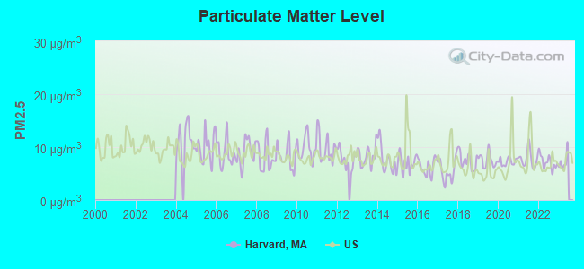
Particulate Matter (PM2.5) [µg/m3] level in 2022 was 7.17. This is about average. Closest monitor was 9.2 miles away from the city center.
| City: | 7.17 |
| U.S.: | 8.11 |
Tornado activity:
Harvard-area historical tornado activity is slightly above Massachusetts state average. It is 25% smaller than the overall U.S. average.
On 6/9/1953, a category F4 (max. wind speeds 207-260 mph) tornado 15.5 miles away from the Harvard town center killed 90 people and injured 1228 people and caused between $50,000,000 and $500,000,000 in damages.
On 10/3/1970, a category F3 (max. wind speeds 158-206 mph) tornado 5.3 miles away from the town center killed one person and caused between $50,000 and $500,000 in damages.
Earthquake activity:
Harvard-area historical earthquake activity is significantly above Massachusetts state average. It is 72% smaller than the overall U.S. average.On 10/7/1983 at 10:18:46, a magnitude 5.3 (5.1 MB, 5.3 LG, 5.1 ML, Class: Moderate, Intensity: VI - VII) earthquake occurred 170.3 miles away from the city center
On 4/20/2002 at 10:50:47, a magnitude 5.3 (5.3 ML, Depth: 3.0 mi) earthquake occurred 173.7 miles away from Harvard center
On 4/20/2002 at 10:50:47, a magnitude 5.2 (5.2 MB, 4.2 MS, 5.2 MW, 5.0 MW) earthquake occurred 172.9 miles away from the city center
On 1/19/1982 at 00:14:42, a magnitude 4.7 (4.5 MB, 4.7 MD, 4.5 LG, Class: Light, Intensity: IV - V) earthquake occurred 68.0 miles away from the city center
On 10/16/2012 at 23:12:25, a magnitude 4.7 (4.7 ML, Depth: 10.0 mi) earthquake occurred 88.6 miles away from Harvard center
On 8/22/1992 at 12:20:32, a magnitude 4.8 (4.8 MB, 3.8 MS, 4.7 LG, Depth: 6.2 mi) earthquake occurred 245.2 miles away from Harvard center
Magnitude types: regional Lg-wave magnitude (LG), body-wave magnitude (MB), duration magnitude (MD), local magnitude (ML), surface-wave magnitude (MS), moment magnitude (MW)
Natural disasters:
The number of natural disasters in Worcester County (27) is a lot greater than the US average (15).Major Disasters (Presidential) Declared: 15
Emergencies Declared: 12
Causes of natural disasters: Floods: 9, Storms: 8, Hurricanes: 6, Snowstorms: 5, Winter Storms: 4, Blizzards: 2, Snows: 2, Fire: 1, Heavy Rain: 1, Snowfall: 1, Tornado: 1, Wind: 1 (Note: some incidents may be assigned to more than one category).

Hospitals and medical centers near Harvard:
- WOODFORD OF AYER NURSING HOME (Nursing Home, about 4 miles away; AYER, MA)
- APPLE VALLEY CENTER (Nursing Home, about 5 miles away; AYER, MA)
- APPLE VALLEY CONTINUING CARE CENTER (Nursing Home, about 5 miles away; AYER, MA)
- NASHOBA VALLEY MEDICAL CENTER Acute Care Hospitals (about 5 miles away; AYER, MA)
- LIFE CARE CENTER OF NASHOBA VALLEY (Nursing Home, about 5 miles away; LITTLETON, MA)
- LITTLETON HOUSE NH (Nursing Home, about 5 miles away; LITTLETON, MA)
- KINDRED NURSING AND REHABILITATION-RIVER TERRACE (Nursing Home, about 6 miles away; LANCASTER, MA)
Colleges/universities with over 2000 students nearest to Harvard:
- Fitchburg State University (about 12 miles; Fitchburg, MA; Full-time enrollment: 5,010)
- Middlesex Community College (about 17 miles; Bedford, MA; FT enrollment: 6,040)
- University of Massachusetts-Lowell (about 17 miles; Lowell, MA; FT enrollment: 12,341)
- Framingham State University (about 18 miles; Framingham, MA; FT enrollment: 5,743)
- Quinsigamond Community College (about 18 miles; Worcester, MA; FT enrollment: 5,877)
- Assumption College (about 20 miles; Worcester, MA; FT enrollment: 2,580)
- Worcester Polytechnic Institute (about 20 miles; Worcester, MA; FT enrollment: 3,930)
Public high school in Harvard:
- BROMFIELD (Students: 758, Location: 14 MASSACHUSETTS AVENUE, Grades: 6-12)
Public elementary/middle school in Harvard:
Points of interest:
Notable locations in Harvard: Shaker Hills Golf Course (A), A and M Orchards (B), Carlson Orchards (C), Doe Orchards (D), Hammerhead Farm (E), Westward Orchards (F), Camp Green Eyrie (G), Harvard University Observatory (H), Harvard Ambulance Service (I), Devens Fire Department (J), Harvard Fire Department Station 2 (K), Harvard Fire Department Station 1 Headquarters (L), Harvard Town Hall (M), Fruitlands Museum Library (N), Fruitlands Museum (O). Display/hide their locations on the map
Churches in Harvard include: New Patriots Church (A), Emmanuel Missionary Baptist Church (B), Church of God (C), Saint Theresas Church (D), Evangelical Congregational Church (E). Display/hide their locations on the map
Cemeteries: Harvard Center Cemetery (1), Bellevue Cemetery (2), Center Cemetery (3). Display/hide their locations on the map
Lakes and reservoirs: Black Pond (A), Little Mirror Lake (B), Mirror Lake (C), Robbins Pond (D), Elizabeth Brook Reservoir (E), Nashua River Reservoir (F), Horse Meadows Reservoir (G), Bare Hill Pond (H). Display/hide their locations on the map
Streams, rivers, and creeks: Cold Spring Brook (A). Display/hide its location on the map
Parks in Harvard include: Oxbow National Wildlife Refuge (1), Harvard Shaker Village Historic District (2), Oxbow National Wildlife Refuge (3). Display/hide their locations on the map
Beach: Harvard Town Beach (A). Display/hide its location on the map
Birthplace of: Harrison Gray Dyar - Chemist.
Drinking water stations with addresses in Harvard and their reported violations in the past:
HARVARD WATER DEPARTMENT (Population served: 1,650, Groundwater):Past health violations:HARVARD GREEN CONDOMINIUMS (Population served: 150, Groundwater):Past monitoring violations:
- MCL, Monthly (TCR) - In SEP-2009, Contaminant: Coliform. Follow-up actions: St AO (w/o penalty) issued (OCT-14-2009), St Compliance achieved (OCT-14-2009)
- Follow-up Or Routine LCR Tap M/R - In JUL-01-2009, Contaminant: Lead and Copper Rule. Follow-up actions: St AO (w/o penalty) issued (DEC-14-2009), St Compliance achieved (DEC-21-2009)
- Follow-up Or Routine LCR Tap M/R - In JUL-01-1997, Contaminant: Lead and Copper Rule. Follow-up actions: St AO (w/o penalty) issued (MAR-31-1998), St Compliance achieved (DEC-27-2005)
- Follow-up Or Routine LCR Tap M/R - In JAN-01-1997, Contaminant: Lead and Copper Rule. Follow-up actions: St AO (w/o penalty) issued (MAR-31-1998), St Compliance achieved (DEC-27-2005)
- 3 minor monitoring violations
- One regular monitoring violation
Past monitoring violations:CENTRE VILLAGE APARTMENTS (Population served: 36, Groundwater):
- 23 regular monitoring violations
Past monitoring violations:
- Follow-up Or Routine LCR Tap M/R - In JUL-01-2012, Contaminant: Lead and Copper Rule. Follow-up actions: St AO (w/o penalty) issued (DEC-05-2012), St Compliance achieved (DEC-05-2012)
- Follow-up Or Routine LCR Tap M/R - In JUL-01-2011, Contaminant: Lead and Copper Rule. Follow-up actions: St AO (w/o penalty) issued (DEC-08-2011), St Compliance achieved (AUG-16-2012)
- Follow-up Or Routine LCR Tap M/R - In JUL-01-2010, Contaminant: Lead and Copper Rule. Follow-up actions: St AO (w/o penalty) issued (NOV-12-2010), St Compliance achieved (DEC-10-2010)
- One routine major monitoring violation
- 28 regular monitoring violations
Drinking water stations with addresses in Harvard that have no violations reported:
- AYER ROAD PROPERTIES LLC (Population served: 150, Primary Water Source Type: Groundwater)
| This town: | 2.8 people |
| Massachusetts: | 2.5 people |
| This town: | 80.5% |
| Whole state: | 63.0% |
| This town: | 3.8% |
| Whole state: | 7.0% |
Likely homosexual households (counted as self-reported same-sex unmarried-partner households)
- Lesbian couples: 0.3% of all households
- Gay men: 0.7% of all households
| This town: | 2.0% |
| Whole state: | 9.3% |
| This town: | 1.7% |
| Whole state: | 4.4% |
People in group quarters in Harvard in 2010:
- 1,194 people in federal prisons
- 54 people in other noninstitutional facilities
- 44 people in emergency and transitional shelters (with sleeping facilities) for people experiencing homelessness
60 people in religious group quarters in 2000
Banks with branches in Harvard (2011 data):
- Rollstone Bank & Trust: Harvard Branch at Route 110 And Old Mill Road, branch established on 1974/06/28. Info updated 2011/07/21: Bank assets: $532.9 mil, Deposits: $299.5 mil, headquarters in Fitchburg, MA, positive income, Commercial Lending Specialization, 7 total offices
For population 15 years and over in Harvard:
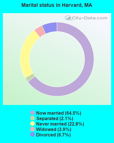
- Never married: 22.8%
- Now married: 64.5%
- Separated: 2.1%
- Widowed: 3.9%
- Divorced: 6.7%
For population 25 years and over in Harvard:
- High school or higher: 91.3%
- Bachelor's degree or higher: 65.1%
- Graduate or professional degree: 36.0%
- Unemployed: 3.2%
- Mean travel time to work (commute): 32.2 minutes
| Here: | 11.8 |
| Massachusetts average: | 13.1 |


Graphs represent county-level data. Detailed 2008 Election Results
Religion statistics for Harvard, MA (based on Worcester County data)


| Religion | Adherents | Congregations |
|---|---|---|
| Catholic | 306,925 | 118 |
| Mainline Protestant | 43,326 | 171 |
| Evangelical Protestant | 37,511 | 203 |
| Other | 18,931 | 69 |
| Orthodox | 7,935 | 15 |
| Black Protestant | 497 | 6 |
| None | 383,427 | - |
Food Environment Statistics:
| This county: | 1.73 / 10,000 pop. |
| Massachusetts: | 1.98 / 10,000 pop. |
| Worcester County: | 0.05 / 10,000 pop. |
| Massachusetts: | 0.05 / 10,000 pop. |
| Worcester County: | 1.79 / 10,000 pop. |
| Massachusetts: | 2.22 / 10,000 pop. |
| Here: | 2.22 / 10,000 pop. |
| Massachusetts: | 1.77 / 10,000 pop. |
| Worcester County: | 7.27 / 10,000 pop. |
| State: | 8.76 / 10,000 pop. |
| Worcester County: | 8.0% |
| Massachusetts: | 8.1% |
| This county: | 24.0% |
| State: | 22.5% |
| This county: | 16.6% |
| State: | 16.5% |
4.71% of this county's 2021 resident taxpayers lived in other counties in 2020 ($76,229 average adjusted gross income)
| Here: | 4.71% |
| Massachusetts average: | 6.35% |
0.02% of residents moved from foreign countries ($100 average AGI)
Worcester County: 0.02% Massachusetts average: 0.01%
Top counties from which taxpayers relocated into this county between 2020 and 2021:
| from Middlesex County, MA | |
| from Norfolk County, MA | |
| from Suffolk County, MA |
4.84% of this county's 2020 resident taxpayers moved to other counties in 2021 ($87,252 average adjusted gross income)
| Here: | 4.84% |
| Massachusetts average: | 7.18% |
0.03% of residents moved to foreign countries ($199 average AGI)
Worcester County: 0.03% Massachusetts average: 0.02%
Top counties to which taxpayers relocated from this county between 2020 and 2021:
| to Middlesex County, MA | |
| to Norfolk County, MA | |
| to Suffolk County, MA |
| Businesses in Harvard, MA | ||||
| Name | Count | Name | Count | |
|---|---|---|---|---|
| Baskin-Robbins | 1 | FedEx | 1 | |
| Dunkin Donuts | 1 | UPS | 1 | |
Strongest AM radio stations in Harvard:
- WRKO (680 AM; 50 kW; BOSTON, MA; Owner: ENTERCOM BOSTON LICENSE, LLC)
- WKOX (1200 AM; 50 kW; FRAMINGHAM, MA; Owner: CAPSTAR TX LIMITED PARTNERSHIP)
- WBIX (1060 AM; 40 kW; NATICK, MA; Owner: LANGER BROADCASTING CORPORATION)
- WEEI (850 AM; 50 kW; BOSTON, MA; Owner: ENTERCOM BOSTON LICENSE, LLC)
- WCRN (830 AM; 50 kW; WORCESTER, MA; Owner: CARTER BROADCASTING CORPORATION)
- WWZN (1510 AM; 50 kW; BOSTON, MA; Owner: ROSE CITY RADIO CORPORATION)
- WAZN (1470 AM; 7 kW; MARLBOROUGH, MA; Owner: MULTICULTURAL RADIO BROADCASTING, INC.)
- WAMG (890 AM; 25 kW; DEDHAM, MA; Owner: MEGA COMMUNICATIONS OF DEDHAM LICENSEE, LLC)
- WBNW (1120 AM; 5 kW; CONCORD, MA; Owner: MONEY MATTERS RADIO, INC.)
- WRCA (1330 AM; 25 kW; WALTHAM, MA; Owner: WRCA LICENSE, LLC)
- WVNE (760 AM; daytime; 25 kW; LEICESTER, MA; Owner: BLOUNT MASSCOM, INC.)
- WALE (990 AM; 50 kW; GREENVILLE, RI; Owner: NORTH AMERICAN BROADCASTING CO., INC.)
- WBZ (1030 AM; 50 kW; BOSTON, MA; Owner: INFINITY BROADCASTING OPERATIONS, INC.)
Strongest FM radio stations in Harvard:
- WXLO (104.5 FM; FITCHBURG, MA; Owner: CITADEL BROADCASTING COMPANY)
- WAAF (107.3 FM; WORCESTER, MA; Owner: ENTERCOM BOSTON LICENSE, LLC)
- WBMX (98.5 FM; BOSTON, MA; Owner: INFINITY RADIO OPERATIONS INC.)
- WJMN (94.5 FM; BOSTON, MA; Owner: AMFM RADIO LICENSES, L.L.C.)
- WCRB (102.5 FM; WALTHAM, MA; Owner: CHARLES RIVER BROADCASTING WCRB LICE)
- WTKK (96.9 FM; BOSTON, MA; Owner: GREATER BOSTON RADIO, INC.)
- WROR-FM (105.7 FM; FRAMINGHAM, MA; Owner: GREATER BOSTON RADIO, INC.)
- WFEX (92.1 FM; PETERBOROUGH, NH; Owner: FNX BROADCASTING OF NEW HAMPSHIRE LLC)
- WBOS (92.9 FM; BROOKLINE, MA; Owner: GREATER BOSTON RADIO, INC.)
- WGBH (89.7 FM; BOSTON, MA; Owner: WGBH EDUCATIONAL FOUNDATION)
- WSRS (96.1 FM; WORCESTER, MA; Owner: CAPSTAR TX LIMITED PARTNERSHIP)
- WBUR-FM (90.9 FM; BOSTON, MA; Owner: TRUSTEES OF BOSTON UNIVERSITY)
- WXKS-FM (107.9 FM; MEDFORD, MA; Owner: AMFM RADIO LICENSES, L.L.C.)
- WMJX (106.7 FM; BOSTON, MA; Owner: GREATER BOSTON RADIO, INC.)
- WODS (103.3 FM; BOSTON, MA; Owner: INFINITY BROADCASTING OPERATIONS, INC.)
- WHOB (106.3 FM; NASHUA, NH; Owner: TELE-MEDIA COMPANY OF NEW HAMPSHIRE, L.L.C.)
- WKLB-FM (99.5 FM; LOWELL, MA; Owner: GREATER BOSTON RADIO, INC.)
- WGIR-FM (101.1 FM; MANCHESTER, NH; Owner: CAPSTAR TX LIMITED PARTNERSHIP)
- W227AM (93.3 FM; ANDOVER, MA; Owner: GREATER BOSTON RADIO, INC.)
- WQLL (96.5 FM; BEDFORD, NH; Owner: SAGA COMMUNICATIONS OF NEW ENGLAND, LLC)
TV broadcast stations around Harvard:
- WUTF (Channel 66; MARLBOROUGH, MA; Owner: TELEFUTURA BOSTON LLC)
- WUNI (Channel 27; WORCESTER, MA; Owner: ENTRAVISION HOLDINGS, LLC)
- WCVB-TV (Channel 5; BOSTON, MA; Owner: WCVB HEARST-ARGYLE TV, INC.)
- WGBH-TV (Channel 2; BOSTON, MA; Owner: WGBH EDUCATIONAL FOUNDATION)
- WHDH-TV (Channel 7; BOSTON, MA; Owner: WHDH-TV)
- WMFP (Channel 62; LAWRENCE, MA; Owner: WSAH LICENSE, INC.)
- WBZ-TV (Channel 4; BOSTON, MA; Owner: VIACOM INC.)
- WGBX-TV (Channel 44; BOSTON, MA; Owner: WGBH EDUCATIONAL FOUNDATION)
- WSBK-TV (Channel 38; BOSTON, MA; Owner: VIACOM INC.)
- WLVI-TV (Channel 56; CAMBRIDGE, MA; Owner: WLVI, INC.)
- WFXT (Channel 25; BOSTON, MA; Owner: FOX TELEVISION STATIONS INC.)
- W40BO (Channel 40; BOSTON, MA; Owner: PAXSON COMMUNICATIONS LPTV, INC.)
- WBPX (Channel 68; BOSTON, MA; Owner: PAXSON BOSTON-68 LICENSE, INC.)
- WFXZ-CA (Channel 24; BOSTON, MA; Owner: BOSTON BROADCASTING CORP.)
- WNDS (Channel 50; DERRY, NH; Owner: CTV OF DERRY, INC)
- WTMU-LP (Channel 32; BOSTON, MA; Owner: ZGS BOSTON, INC.)
- WCEA-LP (Channel 58; BOSTON, MA; Owner: CHANNEL 19 TV CORPORATION)
- WYDN (Channel 48; WORCESTER, MA; Owner: EDUCATIONAL PUBLIC TV CORPORATION)
- WWDP (Channel 46; NORWELL, MA; Owner: NORWELL TELEVISION, LLC)
- National Bridge Inventory (NBI) Statistics
- 25Number of bridges
- 190ft / 57.6mTotal length
- $56,520,000Total costs
- 684,337Total average daily traffic
- 46,707Total average daily truck traffic
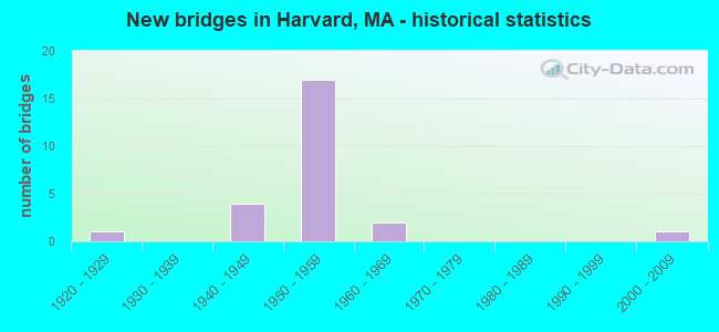
- New bridges - historical statistics
- 11920-1929
- 41940-1949
- 171950-1959
- 21960-1969
- 12000-2009
FCC Registered Antenna Towers: 28 (See the full list of FCC Registered Antenna Towers)
FCC Registered Private Land Mobile Towers: 3 (See the full list of FCC Registered Private Land Mobile Towers in Harvard, MA)
FCC Registered Broadcast Land Mobile Towers: 7 (See the full list of FCC Registered Broadcast Land Mobile Towers)
FCC Registered Microwave Towers: 3 (See the full list of FCC Registered Microwave Towers in this town)
FCC Registered Paging Towers: 13 (See the full list of FCC Registered Paging Towers)
FCC Registered Amateur Radio Licenses: 82 (See the full list of FCC Registered Amateur Radio Licenses in Harvard)
FAA Registered Aircraft: 10 (See the full list of FAA Registered Aircraft in Harvard)
2002 - 2018 National Fire Incident Reporting System (NFIRS) incidents
- Fire incident types reported to NFIRS in Harvard, MA
- 22144.2%Outside Fires
- 20841.6%Structure Fires
- 5611.2%Mobile Property/Vehicle Fires
- 153.0%Other
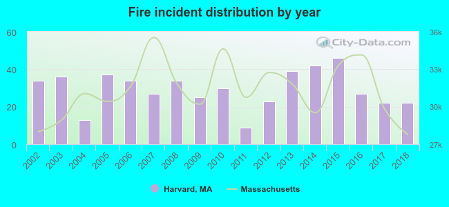 Based on the data from the years 2002 - 2018 the average number of fire incidents per year is 29. The highest number of fire incidents - 46 took place in 2015, and the least - 9 in 2011. The data has a decreasing trend.
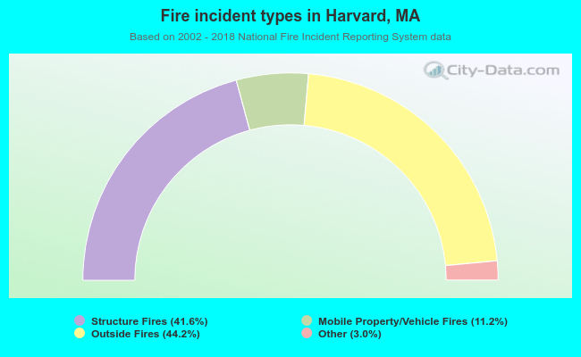 When looking into fire subcategories, the most reports belonged to: Outside Fires (44.2%), and Structure Fires (41.6%).
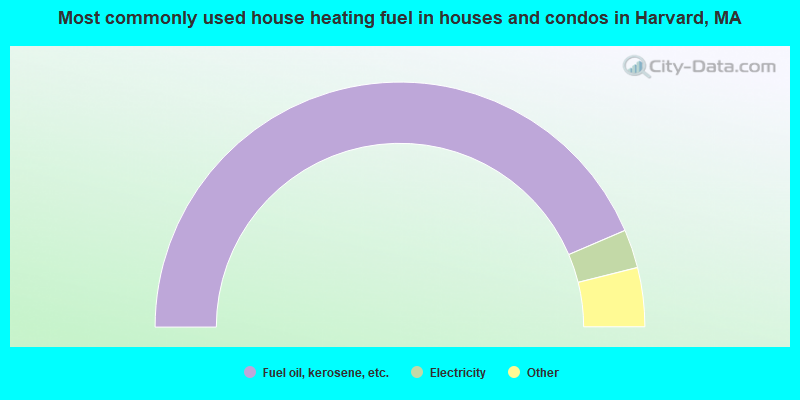
- 87.1%Fuel oil, kerosene, etc.
- 5.1%Electricity
- 3.9%Utility gas
- 2.3%Wood
- 1.2%Bottled, tank, or LP gas
- 0.4%Coal or coke
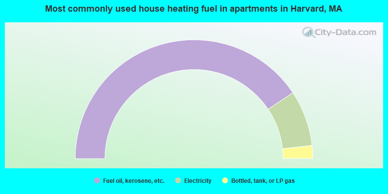
- 81.3%Fuel oil, kerosene, etc.
- 15.2%Electricity
- 3.5%Bottled, tank, or LP gas
Harvard compared to Massachusetts state average:
- Median household income above state average.
- Median house value above state average.
- Unemployed percentage significantly below state average.
- Hispanic race population percentage significantly below state average.
- Renting percentage significantly below state average.
- Length of stay since moving in significantly above state average.
- Number of rooms per house significantly below state average.
- House age significantly below state average.
- Institutionalized population percentage significantly above state average.
- Number of college students below state average.
- Percentage of population with a bachelor's degree or higher above state average.
Harvard on our top lists:
- #1 on the list of "Top 101 cities with largest percentage of females in occupations: social scientists and related workers (population 5,000+)"
- #2 on the list of "Top 101 cities with largest percentage of males in occupations: life and physical scientists (population 5,000+)"
- #5 on the list of "Top 101 cities with largest percentage of females in industries: publishing, and motion picture and sound recording industries (population 5,000+)"
- #5 on the list of "Top 101 cities with largest percentage of females in occupations: media and communication equipment workers (population 5,000+)"
- #5 on the list of "Top 101 cities with largest percentage of females in occupations: physicians and surgeons (population 5,000+)"
- #7 on the list of "Top 101 cities with largest percentage of males in occupations: engineers (population 5,000+)"
- #7 on the list of "Top 101 cities with largest percentage of males in industries: fuel dealers (population 5,000+)"
- #7 on the list of "Top 101 cities with the largest city-data.com crime index increase from 2002 to 2012 (population 5,000+)"
- #7 on the list of "Top 101 cities with largest percentage of males in industries: data processing, libraries, and other information services (population 5,000+)"
- #8 on the list of "Top 101 cities with largest percentage of females in industries: data processing, libraries, and other information services (population 5,000+)"
- #9 on the list of "Top 101 cities with largest percentage of males in occupations: computer specialists (population 5,000+)"
- #9 on the list of "Top 101 cities with largest percentage of females in industries: radio, tv, and computer stores (population 5,000+)"
- #18 on the list of "Top 101 cities with largest percentage of males in industries: publishing, and motion picture and sound recording industries (population 5,000+)"
- #18 on the list of "Top 101 cities with largest percentage of males in industries: drugs, sundries, and chemical and allied products merchant wholesalers (population 5,000+)"
- #19 on the list of "Top 101 cities with largest percentage of males in industries: miscellaneous manufacturing (population 5,000+)"
- #23 on the list of "Top 101 cities with largest percentage of females in industries: computer and electronic products (population 5,000+)"
- #26 on the list of "Top 101 cities with the largest percentage of people in federal prisons and detention centers (population 1,000+)"
- #27 on the list of "Top 101 cities with largest percentage of females in industries: fuel dealers (population 5,000+)"
- #32 on the list of "Top 101 cities with the lowest number of robberies per 100,000 residents (population 5,000+)"
- #37 on the list of "Top 101 cities with largest percentage of males in industries: vending machine operators (population 5,000+)"
- #4 on the list of "Top 101 counties with the highest carbon monoxide air pollution readings in 2012 (ppm)"
- #5 on the list of "Top 101 counties with the most Catholic congregations"
- #12 on the list of "Top 101 counties with the highest surface withdrawal of fresh water for public supply"
- #16 on the list of "Top 101 counties with the highest total withdrawal of fresh water for public supply"
- #23 on the list of "Top 101 counties with the highest Sulfur Oxides Annual air pollution readings in 2012 (µg/m3)"

|
|
Total of 810 patent applications in 2008-2024.