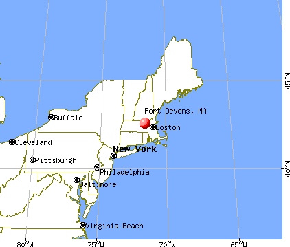
Fort Devens, Massachusetts
Submit your own pictures of this place and show them to the world
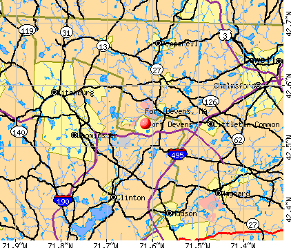
- OSM Map
- General Map
- Google Map
- MSN Map
| Males: 961 | |
| Females: 114 |
| Median resident age: | 32.5 years |
| Massachusetts median age: | 36.5 years |
Median resident age: 32.5 years
Zip codes: 01432.
Detailed information about poverty and poor residents in Fort Devens, MA


- 36535.9%Hispanic
- 33332.7%White alone
- 28828.3%Black alone
- 252.5%Asian alone
- 40.4%American Indian alone
- 20.2%Two or more races
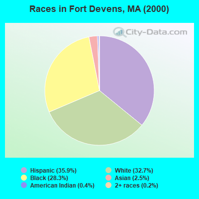
Races in Fort Devens detailed stats: ancestries, foreign born residents, place of birth
 Recent articles from our blog. Our writers, many of them Ph.D. graduates or candidates, create easy-to-read articles on a wide variety of topics.

 | Ayer? (11 replies) |
| Looking for a condo for my mother (11 replies) |
| Boston a boring city? (488 replies) |
| Diverse suburban neighborhood in Central Mass (22 replies) |
| Moving to Devens, MA....please help!!! (12 replies) |
| Need help deciding between Acton, Sudbury or Sharon?? (37 replies) |
Latest news from Fort Devens, MA collected exclusively by city-data.com from local newspapers, TV, and radio stations
Ancestries: West Indian (9.3%), Subsaharan African (7.0%), Irish (6.0%), United States (3.1%), Italian (3.0%), English (2.5%).
Current Local Time: EST time zone
Land area: 6.73 square miles.
Population density: 160 people per square mile (very low).
458 residents are foreign born (41.5% Latin America).
| This place: | 45.0% |
| Massachusetts: | 12.2% |
Nearest city with pop. 50,000+: Nashua, NH  (16.3 miles , pop. 86,605).
Nearest city with pop. 200,000+: Boston, MA (30.7 miles , pop. 589,141).
Nearest city with pop. 1,000,000+: Bronx, NY (165.1 miles , pop. 1,332,650).
Nearest cities:
), ), ), Latitude: 42.54 N, Longitude: 71.62 W
Area code commonly used in this area: 978

| Here: | 3.6% |
| Massachusetts: | 3.5% |
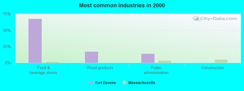
- Food & beverage stores (67.9%)
- Wood products (17.9%)
- Public administration (14.3%)
- Construction (0.0%)
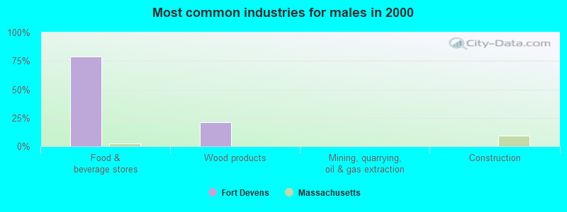
- Food & beverage stores (79.2%)
- Wood products (20.8%)
- Mining, quarrying, oil & gas extraction (0.0%)
- Construction (0.0%)
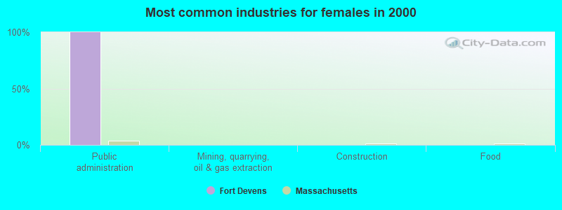
- Public administration (100.0%)
- Mining, quarrying, oil & gas extraction (0.0%)
- Construction (0.0%)
- Food (0.0%)
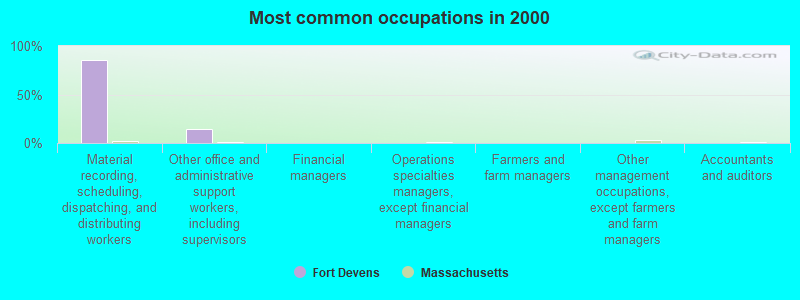
- Material recording, scheduling, dispatching, and distributing workers (85.7%)
- Other office and administrative support workers, including supervisors (14.3%)
- Financial managers (0.0%)
- Operations specialties managers, except financial managers (0.0%)
- Farmers and farm managers (0.0%)
- Other management occupations, except farmers and farm managers (0.0%)
- Accountants and auditors (0.0%)
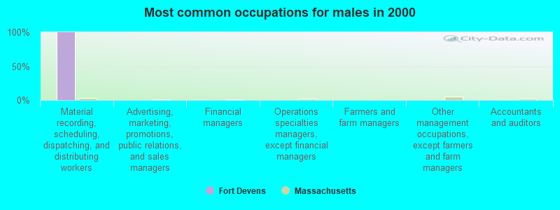
- Material recording, scheduling, dispatching, and distributing workers (100.0%)
- Advertising, marketing, promotions, public relations, and sales managers (0.0%)
- Financial managers (0.0%)
- Operations specialties managers, except financial managers (0.0%)
- Farmers and farm managers (0.0%)
- Other management occupations, except farmers and farm managers (0.0%)
- Accountants and auditors (0.0%)
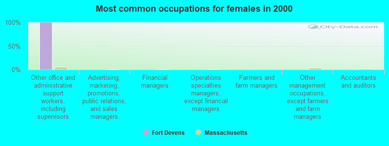
- Other office and administrative support workers, including supervisors (100.0%)
- Advertising, marketing, promotions, public relations, and sales managers (0.0%)
- Financial managers (0.0%)
- Operations specialties managers, except financial managers (0.0%)
- Farmers and farm managers (0.0%)
- Other management occupations, except farmers and farm managers (0.0%)
- Accountants and auditors (0.0%)
Average climate in Fort Devens, Massachusetts
Based on data reported by over 4,000 weather stations


(lower is better)
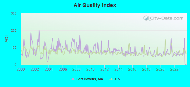
Air Quality Index (AQI) level in 2022 was 63.3. This is about average.
| City: | 63.3 |
| U.S.: | 72.6 |
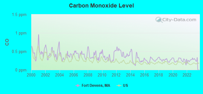
Carbon Monoxide (CO) [ppm] level in 2022 was 0.259. This is about average. Closest monitor was 16.8 miles away from the city center.
| City: | 0.259 |
| U.S.: | 0.251 |
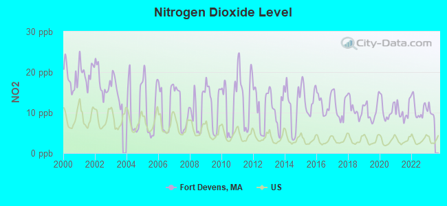
Nitrogen Dioxide (NO2) [ppb] level in 2022 was 11.0. This is significantly worse than average. Closest monitor was 2.6 miles away from the city center.
| City: | 11.0 |
| U.S.: | 5.1 |
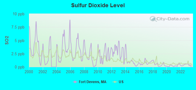
Sulfur Dioxide (SO2) [ppb] level in 2022 was 0.370. This is significantly better than average. Closest monitor was 2.6 miles away from the city center.
| City: | 0.370 |
| U.S.: | 1.515 |
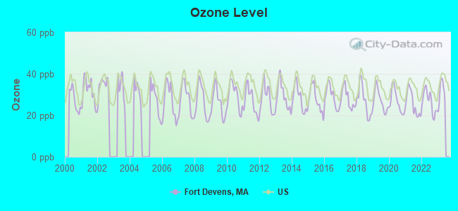
Ozone [ppb] level in 2022 was 26.5. This is better than average. Closest monitor was 8.8 miles away from the city center.
| City: | 26.5 |
| U.S.: | 33.3 |
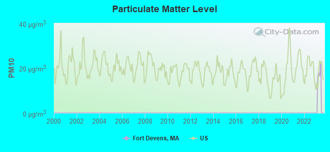
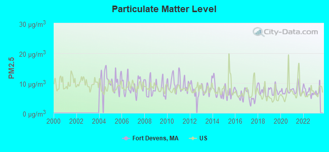
Particulate Matter (PM2.5) [µg/m3] level in 2022 was 7.15. This is about average. Closest monitor was 9.7 miles away from the city center.
| City: | 7.15 |
| U.S.: | 8.11 |
Tornado activity:
Fort Devens-area historical tornado activity is slightly above Massachusetts state average. It is 24% smaller than the overall U.S. average.
On 6/9/1953, a category F4 (max. wind speeds 207-260 mph) tornado 17.1 miles away from the Fort Devens place center killed 90 people and injured 1228 people and caused between $50,000,000 and $500,000,000 in damages.
On 10/3/1970, a category F3 (max. wind speeds 158-206 mph) tornado 5.4 miles away from the place center killed one person and caused between $50,000 and $500,000 in damages.
Earthquake activity:
Fort Devens-area historical earthquake activity is significantly above Massachusetts state average. It is 72% smaller than the overall U.S. average.On 10/7/1983 at 10:18:46, a magnitude 5.3 (5.1 MB, 5.3 LG, 5.1 ML, Class: Moderate, Intensity: VI - VII) earthquake occurred 168.7 miles away from Fort Devens center
On 4/20/2002 at 10:50:47, a magnitude 5.3 (5.3 ML, Depth: 3.0 mi) earthquake occurred 171.9 miles away from Fort Devens center
On 4/20/2002 at 10:50:47, a magnitude 5.2 (5.2 MB, 4.2 MS, 5.2 MW, 5.0 MW) earthquake occurred 171.2 miles away from Fort Devens center
On 1/19/1982 at 00:14:42, a magnitude 4.7 (4.5 MB, 4.7 MD, 4.5 LG, Class: Light, Intensity: IV - V) earthquake occurred 66.6 miles away from Fort Devens center
On 10/16/2012 at 23:12:25, a magnitude 4.7 (4.7 ML, Depth: 10.0 mi) earthquake occurred 87.9 miles away from Fort Devens center
On 8/22/1992 at 12:20:32, a magnitude 4.8 (4.8 MB, 3.8 MS, 4.7 LG, Depth: 6.2 mi) earthquake occurred 246.8 miles away from the city center
Magnitude types: regional Lg-wave magnitude (LG), body-wave magnitude (MB), duration magnitude (MD), local magnitude (ML), surface-wave magnitude (MS), moment magnitude (MW)
Natural disasters:
The number of natural disasters in Worcester County (27) is a lot greater than the US average (15).Major Disasters (Presidential) Declared: 15
Emergencies Declared: 12
Causes of natural disasters: Floods: 9, Storms: 8, Hurricanes: 6, Snowstorms: 5, Winter Storms: 4, Blizzards: 2, Snows: 2, Fire: 1, Heavy Rain: 1, Snowfall: 1, Tornado: 1, Wind: 1 (Note: some incidents may be assigned to more than one category).

Hospitals and medical centers near Fort Devens:
- WOODFORD OF AYER NURSING HOME (Nursing Home, about 3 miles away; AYER, MA)
- APPLE VALLEY CENTER (Nursing Home, about 4 miles away; AYER, MA)
- APPLE VALLEY CONTINUING CARE CENTER (Nursing Home, about 4 miles away; AYER, MA)
- NASHOBA VALLEY MEDICAL CENTER Acute Care Hospitals (about 4 miles away; AYER, MA)
- SEVEN HILLS PEDIATRIC CENTER (Nursing Home, about 6 miles away; GROTON, MA)
- KINDRED NURSING AND REHABILITATION-RIVER TERRACE (Nursing Home, about 6 miles away; LANCASTER, MA)
- LIFE CARE CENTER OF NASHOBA VALLEY (Nursing Home, about 7 miles away; LITTLETON, MA)
Colleges/universities with over 2000 students nearest to Fort Devens:
- Fitchburg State University (about 10 miles; Fitchburg, MA; Full-time enrollment: 5,010)
- University of Massachusetts-Lowell (about 17 miles; Lowell, MA; FT enrollment: 12,341)
- Middlesex Community College (about 18 miles; Bedford, MA; FT enrollment: 6,040)
- Quinsigamond Community College (about 18 miles; Worcester, MA; FT enrollment: 5,877)
- Framingham State University (about 19 miles; Framingham, MA; FT enrollment: 5,743)
- Mount Wachusett Community College (about 20 miles; Gardner, MA; FT enrollment: 3,143)
- Assumption College (about 20 miles; Worcester, MA; FT enrollment: 2,580)
Points of interest:
Notable location: Devens Fire Department (A). Display/hide its location on the map
Church in Fort Devens: New Patriots Church (A). Display/hide its location on the map
Lakes and reservoirs: Little Mirror Lake (A), Mirror Lake (B), Robbins Pond (C), Nashua River Reservoir (D). Display/hide their locations on the map
Streams, rivers, and creeks: Trout Brook (A), Morse Brook (B), Mulpus Brook (C), Nonacoicus Brook (D), Walker Brook (E), Willow Branch (F), Catacoonamug Brook (G). Display/hide their locations on the map
Birthplace of: Brett Quigley - PGA Tour Golf player (born: 8/18/69).
| This place: | 2.0 people |
| Massachusetts: | 2.5 people |
| This place: | 33.3% |
| Whole state: | 65.0% |
| This place: | 0.0% |
| Whole state: | 5.4% |
No gay or lesbian households reported
| This place: | 78.6% |
| Whole state: | 9.3% |
| This place: | 41.2% |
| Whole state: | 4.4% |
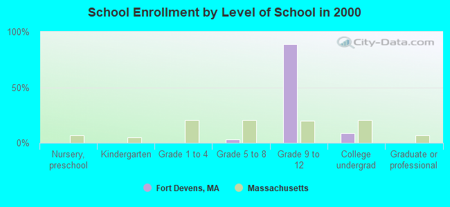
264 people in job corps and vocational training facilities in 2000
For population 15 years and over in Fort Devens:
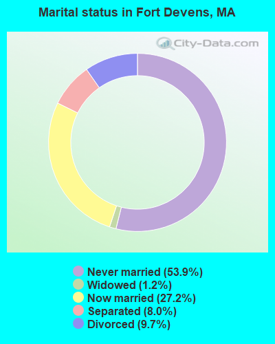
- Never married: 53.9%
- Now married: 27.2%
- Separated: 8.0%
- Widowed: 1.2%
- Divorced: 9.7%
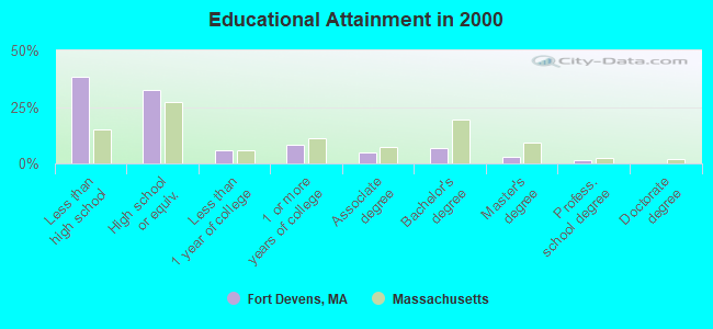
For population 25 years and over in Fort Devens:
- High school or higher: 61.9%
- Bachelor's degree or higher: 10.9%
- Graduate or professional degree: 4.2%
- Unemployed: 28.2%
- Mean travel time to work (commute): 21.9 minutes
| Here: | 15.0 |
| Massachusetts average: | 13.1 |


Graphs represent county-level data. Detailed 2008 Election Results
Religion statistics for Fort Devens, MA (based on Worcester County data)


| Religion | Adherents | Congregations |
|---|---|---|
| Catholic | 306,925 | 118 |
| Mainline Protestant | 43,326 | 171 |
| Evangelical Protestant | 37,511 | 203 |
| Other | 18,931 | 69 |
| Orthodox | 7,935 | 15 |
| Black Protestant | 497 | 6 |
| None | 383,427 | - |
Food Environment Statistics:
| Worcester County: | 1.73 / 10,000 pop. |
| Massachusetts: | 1.98 / 10,000 pop. |
| This county: | 0.05 / 10,000 pop. |
| Massachusetts: | 0.05 / 10,000 pop. |
| Worcester County: | 1.79 / 10,000 pop. |
| Massachusetts: | 2.22 / 10,000 pop. |
| Worcester County: | 2.22 / 10,000 pop. |
| Massachusetts: | 1.77 / 10,000 pop. |
| This county: | 7.27 / 10,000 pop. |
| Massachusetts: | 8.76 / 10,000 pop. |
| Worcester County: | 8.0% |
| State: | 8.1% |
| Worcester County: | 24.0% |
| Massachusetts: | 22.5% |
| Worcester County: | 16.6% |
| Massachusetts: | 16.5% |
4.71% of this county's 2021 resident taxpayers lived in other counties in 2020 ($76,229 average adjusted gross income)
| Here: | 4.71% |
| Massachusetts average: | 6.35% |
0.02% of residents moved from foreign countries ($100 average AGI)
Worcester County: 0.02% Massachusetts average: 0.01%
Top counties from which taxpayers relocated into this county between 2020 and 2021:
| from Middlesex County, MA | |
| from Norfolk County, MA | |
| from Suffolk County, MA |
4.84% of this county's 2020 resident taxpayers moved to other counties in 2021 ($87,252 average adjusted gross income)
| Here: | 4.84% |
| Massachusetts average: | 7.18% |
0.03% of residents moved to foreign countries ($199 average AGI)
Worcester County: 0.03% Massachusetts average: 0.02%
Top counties to which taxpayers relocated from this county between 2020 and 2021:
| to Middlesex County, MA | |
| to Norfolk County, MA | |
| to Suffolk County, MA |
Strongest AM radio stations in Fort Devens:
- WRKO (680 AM; 50 kW; BOSTON, MA; Owner: ENTERCOM BOSTON LICENSE, LLC)
- WKOX (1200 AM; 50 kW; FRAMINGHAM, MA; Owner: CAPSTAR TX LIMITED PARTNERSHIP)
- WBIX (1060 AM; 40 kW; NATICK, MA; Owner: LANGER BROADCASTING CORPORATION)
- WEEI (850 AM; 50 kW; BOSTON, MA; Owner: ENTERCOM BOSTON LICENSE, LLC)
- WCRN (830 AM; 50 kW; WORCESTER, MA; Owner: CARTER BROADCASTING CORPORATION)
- WWZN (1510 AM; 50 kW; BOSTON, MA; Owner: ROSE CITY RADIO CORPORATION)
- WAMG (890 AM; 25 kW; DEDHAM, MA; Owner: MEGA COMMUNICATIONS OF DEDHAM LICENSEE, LLC)
- WAZN (1470 AM; 7 kW; MARLBOROUGH, MA; Owner: MULTICULTURAL RADIO BROADCASTING, INC.)
- WRCA (1330 AM; 25 kW; WALTHAM, MA; Owner: WRCA LICENSE, LLC)
- WBNW (1120 AM; 5 kW; CONCORD, MA; Owner: MONEY MATTERS RADIO, INC.)
- WVNE (760 AM; daytime; 25 kW; LEICESTER, MA; Owner: BLOUNT MASSCOM, INC.)
- WALE (990 AM; 50 kW; GREENVILLE, RI; Owner: NORTH AMERICAN BROADCASTING CO., INC.)
- WBZ (1030 AM; 50 kW; BOSTON, MA; Owner: INFINITY BROADCASTING OPERATIONS, INC.)
Strongest FM radio stations in Fort Devens:
- WXLO (104.5 FM; FITCHBURG, MA; Owner: CITADEL BROADCASTING COMPANY)
- WAAF (107.3 FM; WORCESTER, MA; Owner: ENTERCOM BOSTON LICENSE, LLC)
- WFEX (92.1 FM; PETERBOROUGH, NH; Owner: FNX BROADCASTING OF NEW HAMPSHIRE LLC)
- WBMX (98.5 FM; BOSTON, MA; Owner: INFINITY RADIO OPERATIONS INC.)
- WJMN (94.5 FM; BOSTON, MA; Owner: AMFM RADIO LICENSES, L.L.C.)
- WCRB (102.5 FM; WALTHAM, MA; Owner: CHARLES RIVER BROADCASTING WCRB LICE)
- WTKK (96.9 FM; BOSTON, MA; Owner: GREATER BOSTON RADIO, INC.)
- WROR-FM (105.7 FM; FRAMINGHAM, MA; Owner: GREATER BOSTON RADIO, INC.)
- WBOS (92.9 FM; BROOKLINE, MA; Owner: GREATER BOSTON RADIO, INC.)
- WGBH (89.7 FM; BOSTON, MA; Owner: WGBH EDUCATIONAL FOUNDATION)
- WSRS (96.1 FM; WORCESTER, MA; Owner: CAPSTAR TX LIMITED PARTNERSHIP)
- WBUR-FM (90.9 FM; BOSTON, MA; Owner: TRUSTEES OF BOSTON UNIVERSITY)
- WXKS-FM (107.9 FM; MEDFORD, MA; Owner: AMFM RADIO LICENSES, L.L.C.)
- WMJX (106.7 FM; BOSTON, MA; Owner: GREATER BOSTON RADIO, INC.)
- WODS (103.3 FM; BOSTON, MA; Owner: INFINITY BROADCASTING OPERATIONS, INC.)
- WHOB (106.3 FM; NASHUA, NH; Owner: TELE-MEDIA COMPANY OF NEW HAMPSHIRE, L.L.C.)
- WKLB-FM (99.5 FM; LOWELL, MA; Owner: GREATER BOSTON RADIO, INC.)
- WGIR-FM (101.1 FM; MANCHESTER, NH; Owner: CAPSTAR TX LIMITED PARTNERSHIP)
- WQLL (96.5 FM; BEDFORD, NH; Owner: SAGA COMMUNICATIONS OF NEW ENGLAND, LLC)
- WLMW (90.7 FM; MANCHESTER, NH; Owner: KNOWLEDGE FOR LIFE)
TV broadcast stations around Fort Devens:
- WUTF (Channel 66; MARLBOROUGH, MA; Owner: TELEFUTURA BOSTON LLC)
- WUNI (Channel 27; WORCESTER, MA; Owner: ENTRAVISION HOLDINGS, LLC)
- WCVB-TV (Channel 5; BOSTON, MA; Owner: WCVB HEARST-ARGYLE TV, INC.)
- WGBH-TV (Channel 2; BOSTON, MA; Owner: WGBH EDUCATIONAL FOUNDATION)
- WHDH-TV (Channel 7; BOSTON, MA; Owner: WHDH-TV)
- WMFP (Channel 62; LAWRENCE, MA; Owner: WSAH LICENSE, INC.)
- WBZ-TV (Channel 4; BOSTON, MA; Owner: VIACOM INC.)
- WGBX-TV (Channel 44; BOSTON, MA; Owner: WGBH EDUCATIONAL FOUNDATION)
- WSBK-TV (Channel 38; BOSTON, MA; Owner: VIACOM INC.)
- WLVI-TV (Channel 56; CAMBRIDGE, MA; Owner: WLVI, INC.)
- WFXT (Channel 25; BOSTON, MA; Owner: FOX TELEVISION STATIONS INC.)
- W40BO (Channel 40; BOSTON, MA; Owner: PAXSON COMMUNICATIONS LPTV, INC.)
- WFXZ-CA (Channel 24; BOSTON, MA; Owner: BOSTON BROADCASTING CORP.)
- WBPX (Channel 68; BOSTON, MA; Owner: PAXSON BOSTON-68 LICENSE, INC.)
- WNDS (Channel 50; DERRY, NH; Owner: CTV OF DERRY, INC)
- WTMU-LP (Channel 32; BOSTON, MA; Owner: ZGS BOSTON, INC.)
- WCEA-LP (Channel 58; BOSTON, MA; Owner: CHANNEL 19 TV CORPORATION)
- WYDN (Channel 48; WORCESTER, MA; Owner: EDUCATIONAL PUBLIC TV CORPORATION)
- National Bridge Inventory (NBI) Statistics
- 2Number of bridges
- 20ft / 5.8mTotal length
- $1,758,000Total costs
- 7,477Total average daily traffic
- 981Total average daily truck traffic
- 10,234Total future (year 2032) average daily traffic
FCC Registered Broadcast Land Mobile Towers:
1- Bldg 3710 Nationa Guard (Lat: 42.547306 Lon: -71.582833), Call Sign: KJL648, Licensee ID: L00003516,
Assigned Frequencies: 45.3600 MHz, Grant Date: 03/01/2005, Expiration Date: 05/28/2015, Cancellation Date: 08/01/2015, Registrant: Commonwealth Of Massachusetts, 400 Worcester Rd, Framingham, MA 01702-5399, Phone: (508) 820-2023, Fax: (508) 875-2517, Email:
FCC Registered Amateur Radio Licenses:
15 (See the full list of FCC Registered Amateur Radio Licenses in Fort Devens)FAA Registered Aircraft:
1- Aircraft: CESSNA 182C (Category: Land, Seats: 4, Weight: Up to 12,499 Pounds, Speed: 119 mph), Engine: CONT MOTOR O-470 SERIES (230 HP) (Reciprocating)
N-Number: 8776T, N8776T, N-8776T, Serial Number: 52676, Year manufactured: 1960, Certificate Issue Date: 04/28/1977
Registrant (Individual): James A Reid, 700g Salerno Circle, Fort Devens, MA 01433
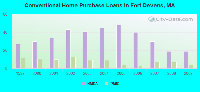
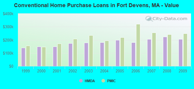
| Home Mortgage Disclosure Act Aggregated Statistics For Year 2009 (Based on 2 partial tracts) | ||||||||||
| A) FHA, FSA/RHS & VA Home Purchase Loans | B) Conventional Home Purchase Loans | C) Refinancings | D) Home Improvement Loans | F) Non-occupant Loans on < 5 Family Dwellings (A B C & D) | ||||||
|---|---|---|---|---|---|---|---|---|---|---|
| Number | Average Value | Number | Average Value | Number | Average Value | Number | Average Value | Number | Average Value | |
| LOANS ORIGINATED | 10 | $255,480 | 19 | $206,038 | 47 | $231,687 | 2 | $63,740 | 3 | $196,327 |
| APPLICATIONS APPROVED, NOT ACCEPTED | 1 | $212,700 | 1 | $260,300 | 4 | $222,440 | 0 | $0 | 0 | $0 |
| APPLICATIONS DENIED | 2 | $221,635 | 2 | $155,805 | 17 | $259,868 | 1 | $119,820 | 0 | $0 |
| APPLICATIONS WITHDRAWN | 1 | $224,310 | 2 | $238,820 | 12 | $252,304 | 0 | $0 | 0 | $0 |
| FILES CLOSED FOR INCOMPLETENESS | 0 | $0 | 1 | $259,960 | 5 | $253,732 | 0 | $0 | 0 | $0 |
Detailed HMDA statistics for the following Tracts: 3022.00 , 3251.00, 7141.00
| Private Mortgage Insurance Companies Aggregated Statistics For Year 2009 (Based on 2 partial tracts) | ||||
| A) Conventional Home Purchase Loans | B) Refinancings | |||
|---|---|---|---|---|
| Number | Average Value | Number | Average Value | |
| LOANS ORIGINATED | 4 | $248,860 | 4 | $228,178 |
| APPLICATIONS APPROVED, NOT ACCEPTED | 3 | $199,693 | 2 | $261,775 |
| APPLICATIONS DENIED | 0 | $0 | 0 | $0 |
| APPLICATIONS WITHDRAWN | 0 | $0 | 0 | $0 |
| FILES CLOSED FOR INCOMPLETENESS | 0 | $0 | 0 | $0 |
Detailed PMIC statistics for the following Tracts: 3251.00 , 7141.00
Fort Devens compared to Massachusetts state average:
- Median household income significantly below state average.
- Median house value significantly below state average.
- Unemployed percentage above state average.
- Black race population percentage significantly above state average.
- Hispanic race population percentage above state average.
- Median age below state average.
- Foreign-born population percentage significantly above state average.
- Renting percentage significantly below state average.
- Length of stay since moving in significantly above state average.
- Number of rooms per house significantly below state average.
- House age significantly below state average.
- Institutionalized population percentage significantly above state average.
- Number of college students below state average.
- Percentage of population with a bachelor's degree or higher significantly below state average.
Fort Devens on our top lists:
- #1 on the list of "Top 101 cities with the largest percentage of people in federal prisons and detention centers (population 1,000+)"
- #2 on the list of "Top 101 cities with the largest percentage of people in job corps and vocational training facilities (population 1,000+)"
- #3 on the list of "Top 101 cities with the least people driving a car to work alone (population 500+)"
- #8 on the list of "Top 101 cities with the most residents born in Other Caribbean (population 500+)"
- #13 on the list of "Top 101 cities with the most residents born in Colombia (population 500+)"
- #46 on the list of "Top 101 cities with the lowest percentage of family households, population 1,000+"
- #4 on the list of "Top 101 counties with the highest carbon monoxide air pollution readings in 2012 (ppm)"
- #5 on the list of "Top 101 counties with the most Catholic congregations"
- #12 on the list of "Top 101 counties with the highest surface withdrawal of fresh water for public supply"
- #16 on the list of "Top 101 counties with the highest total withdrawal of fresh water for public supply"
- #23 on the list of "Top 101 counties with the highest Sulfur Oxides Annual air pollution readings in 2012 (µg/m3)"