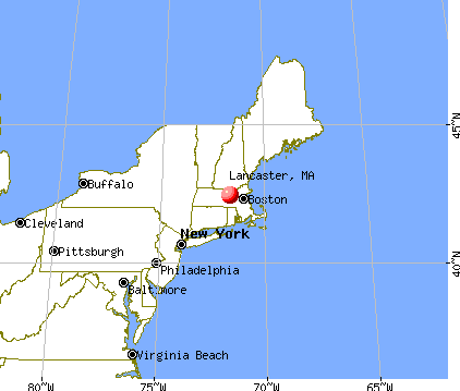
Lancaster, Massachusetts
Submit your own pictures of this town and show them to the world
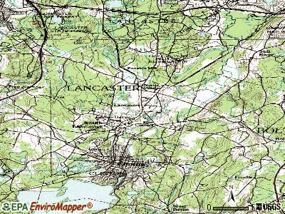
- OSM Map
- General Map
- Google Map
- MSN Map

Population change since 2000: +9.1%
| Males: 4,537 | |
| Females: 3,518 |
| Median resident age: | 38.9 years |
| Massachusetts median age: | 39.2 years |
Zip codes: 01523.
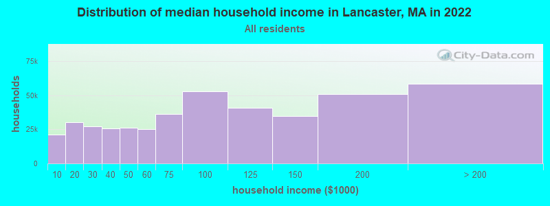
| Lancaster: | $109,461 |
| MA: | $94,488 |
Estimated per capita income in 2022: $40,965 (it was $21,010 in 2000)
Lancaster town income, earnings, and wages data
Estimated median house or condo value in 2022: $476,095 (it was $172,400 in 2000)
| Lancaster: | $476,095 |
| MA: | $534,700 |
Mean prices in 2022: all housing units: $419,164; detached houses: $447,621; townhouses or other attached units: $343,592; in 2-unit structures: $323,295; in 3-to-4-unit structures: $332,295; in 5-or-more-unit structures: $232,758; mobile homes: $113,885
Detailed information about poverty and poor residents in Lancaster, MA


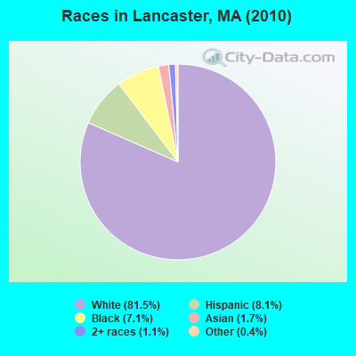
- 6,56881.5%White alone
- 6558.1%Hispanic
- 5727.1%Black alone
- 1401.7%Asian alone
- 851.1%Two or more races
- 300.4%Other race alone
- 50.06%American Indian alone
Races in Lancaster detailed stats: ancestries, foreign born residents, place of birth
Type |
2009 |
2010 |
2011 |
2012 |
2013 |
2014 |
2015 |
2016 |
2017 |
2018 |
2019 |
2020 |
2021 |
2022 |
|---|---|---|---|---|---|---|---|---|---|---|---|---|---|---|
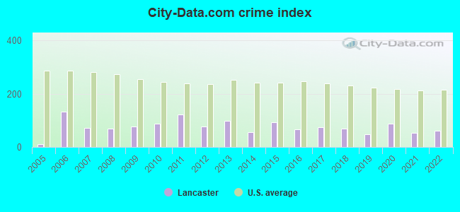
| Murders (per 100,000) | 1 (13.9) | 0 (0.0) | 0 (0.0) | 0 (0.0) | 0 (0.0) | 0 (0.0) | 0 (0.0) | 0 (0.0) | 0 (0.0) | 0 (0.0) | 0 (0.0) | 0 (0.0) | 0 (0.0) | 0 (0.0) |
| Rapes (per 100,000) | 0 (0.0) | 3 (37.2) | 3 (37.0) | 0 (0.0) | 3 (37.8) | 0 (0.0) | 3 (36.9) | 2 (24.5) | 2 (24.4) | 0 (0.0) | 1 (12.3) | 4 (49.8) | 0 (0.0) | 2 (23.5) |
| Robberies (per 100,000) | 0 (0.0) | 1 (12.4) | 5 (61.7) | 1 (12.3) | 1 (12.6) | 2 (24.8) | 1 (12.3) | 2 (24.5) | 1 (12.2) | 0 (0.0) | 0 (0.0) | 2 (24.9) | 0 (0.0) | 0 (0.0) |
| Assaults (per 100,000) | 4 (55.7) | 4 (49.7) | 6 (74.0) | 8 (98.2) | 4 (50.4) | 2 (24.8) | 6 (73.8) | 3 (36.8) | 7 (85.2) | 15 (185.8) | 5 (61.5) | 8 (99.5) | 13 (164.6) | 9 (105.8) |
| Burglaries (per 100,000) | 12 (167.1) | 22 (273.1) | 29 (357.8) | 34 (417.3) | 30 (377.7) | 20 (247.7) | 19 (233.8) | 8 (98.2) | 13 (158.3) | 12 (148.6) | 7 (86.0) | 11 (136.8) | 13 (164.6) | 10 (117.6) |
| Thefts (per 100,000) | 33 (459.4) | 46 (571.1) | 55 (678.7) | 46 (564.6) | 48 (604.3) | 47 (582.0) | 45 (553.8) | 46 (564.4) | 40 (487.1) | 36 (445.9) | 32 (393.3) | 17 (211.4) | 15 (189.9) | 27 (317.5) |
| Auto thefts (per 100,000) | 7 (97.5) | 4 (49.7) | 6 (74.0) | 2 (24.5) | 2 (25.2) | 2 (24.8) | 8 (98.4) | 2 (24.5) | 3 (36.5) | 5 (61.9) | 4 (49.2) | 3 (37.3) | 1 (12.7) | 0 (0.0) |
| Arson (per 100,000) | 1 (13.9) | 1 (12.4) | 2 (24.7) | 1 (12.3) | 1 (12.6) | 0 (0.0) | 0 (0.0) | 0 (0.0) | 0 (0.0) | 1 (12.4) | 0 (0.0) | 0 (0.0) | 0 (0.0) | 0 (0.0) |
| City-Data.com crime index | 76.8 | 89.4 | 121.1 | 77.1 | 96.7 | 55.0 | 94.4 | 65.8 | 73.7 | 70.3 | 47.8 | 88.2 | 53.0 | 60.9 |
The City-Data.com crime index weighs serious crimes and violent crimes more heavily. Higher means more crime, U.S. average is 246.1. It adjusts for the number of visitors and daily workers commuting into cities.
Crime rate in Lancaster detailed stats: murders, rapes, robberies, assaults, burglaries, thefts, arson
Full-time law enforcement employees in 2021, including police officers: 10 (8 officers - 7 male; 1 female).
| Officers per 1,000 residents here: | 1.01 |
| Massachusetts average: | 2.53 |
 Recent articles from our blog. Our writers, many of them Ph.D. graduates or candidates, create easy-to-read articles on a wide variety of topics.

 | Traveling from Haverhill ma to Lancaster pa. (10 replies) |
| Taxes driving wealth out of Massachusetts and into Florida, New Hampshire (127 replies) |
| Worcester MA move considerations questions (63 replies) |
| Describe Holden? (48 replies) |
| Ayer (47 replies) |
| Individual Votes By Cities/Towns Whether To Allow Marijuana businesses (599 replies) |
Latest news from Lancaster, MA collected exclusively by city-data.com from local newspapers, TV, and radio stations
Ancestries: Irish (18.0%), Italian (13.3%), United States (12.7%), English (12.5%), French (9.5%), German (6.0%).
Current Local Time: EST time zone
Incorporated in 1653
Elevation: 300 feet
Land area: 27.7 square miles.
Population density: 291 people per square mile (very low).
455 residents are foreign born (2.7% Latin America, 2.2% Europe, 0.6% North America).
| This town: | 6.2% |
| Massachusetts: | 12.2% |
| Lancaster town: | 1.3% ($2,212) |
| Massachusetts: | 1.3% ($2,336) |
Nearest city with pop. 50,000+: Worcester, MA  (15.5 miles , pop. 172,648).
Nearest city with pop. 200,000+: Boston, MA (31.7 miles , pop. 589,141).
Nearest city with pop. 1,000,000+: Bronx, NY (159.8 miles , pop. 1,332,650).
Nearest cities:
), ), Latitude: 42.47 N, Longitude: 71.68 W
Area code commonly used in this area: 978

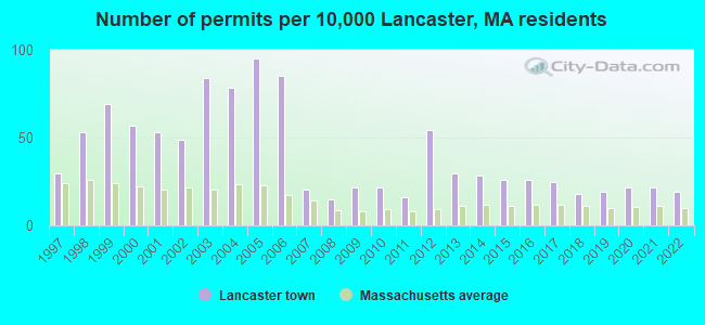
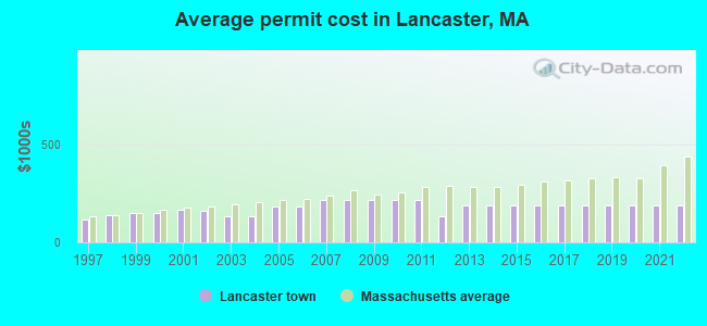
Single-family new house construction building permits:
- 2022: 14 buildings, average cost: $189,800
- 2021: 16 buildings, average cost: $189,800
- 2020: 16 buildings, average cost: $189,800
- 2019: 14 buildings, average cost: $189,800
- 2018: 13 buildings, average cost: $189,800
- 2017: 18 buildings, average cost: $189,800
- 2016: 19 buildings, average cost: $189,800
- 2015: 19 buildings, average cost: $189,800
- 2014: 21 buildings, average cost: $189,800
- 2013: 22 buildings, average cost: $189,800
- 2012: 40 buildings, average cost: $129,700
- 2011: 12 buildings, average cost: $215,900
- 2010: 16 buildings, average cost: $215,900
- 2009: 16 buildings, average cost: $215,900
- 2008: 11 buildings, average cost: $215,900
- 2007: 15 buildings, average cost: $215,900
- 2006: 63 buildings, average cost: $180,400
- 2005: 70 buildings, average cost: $180,400
- 2004: 58 buildings, average cost: $133,000
- 2003: 62 buildings, average cost: $132,000
- 2002: 36 buildings, average cost: $158,200
- 2001: 39 buildings, average cost: $165,200
- 2000: 42 buildings, average cost: $148,100
- 1999: 51 buildings, average cost: $147,200
- 1998: 39 buildings, average cost: $137,300
- 1997: 22 buildings, average cost: $117,000
| Here: | 3.0% |
| Massachusetts: | 3.5% |
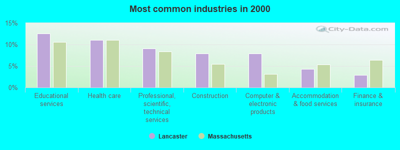
- Educational services (12.6%)
- Health care (11.1%)
- Professional, scientific, technical services (9.1%)
- Construction (7.9%)
- Computer & electronic products (7.9%)
- Accommodation & food services (4.3%)
- Finance & insurance (2.9%)
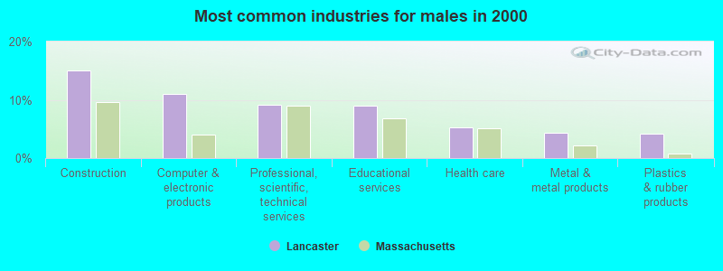
- Construction (15.0%)
- Computer & electronic products (11.0%)
- Professional, scientific, technical services (9.1%)
- Educational services (9.0%)
- Health care (5.3%)
- Metal & metal products (4.3%)
- Plastics & rubber products (4.2%)
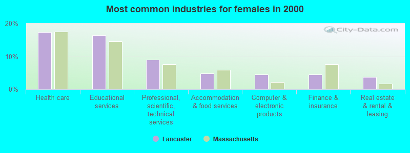
- Health care (17.4%)
- Educational services (16.5%)
- Professional, scientific, technical services (9.1%)
- Accommodation & food services (4.8%)
- Computer & electronic products (4.5%)
- Finance & insurance (4.4%)
- Real estate & rental & leasing (3.8%)
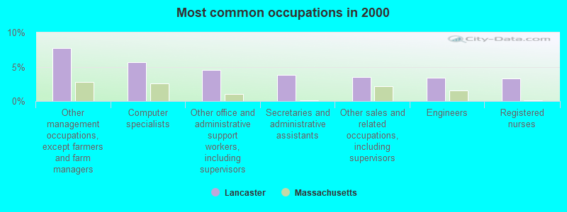
- Other management occupations, except farmers and farm managers (7.8%)
- Computer specialists (5.6%)
- Other office and administrative support workers, including supervisors (4.5%)
- Secretaries and administrative assistants (3.8%)
- Other sales and related occupations, including supervisors (3.5%)
- Engineers (3.4%)
- Registered nurses (3.3%)
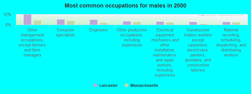
- Other management occupations, except farmers and farm managers (12.0%)
- Computer specialists (6.5%)
- Engineers (6.2%)
- Other production occupations, including supervisors (4.2%)
- Electrical equipment mechanics and other installation, maintenance, and repair workers, including supervisors (4.2%)
- Construction traders workers except carpenters, electricians, painters, plumbers, and construction laborers (3.8%)
- Material recording, scheduling, dispatching, and distributing workers (3.5%)
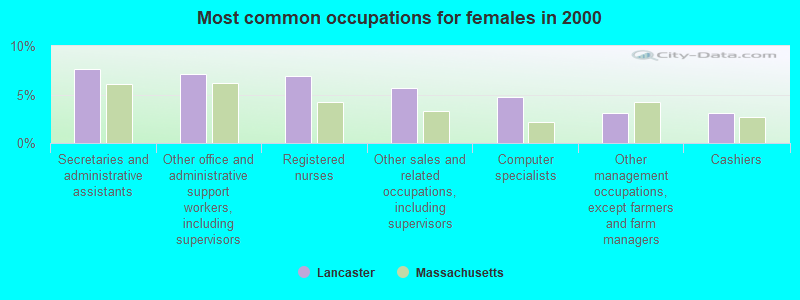
- Secretaries and administrative assistants (7.7%)
- Other office and administrative support workers, including supervisors (7.1%)
- Registered nurses (6.9%)
- Other sales and related occupations, including supervisors (5.7%)
- Computer specialists (4.7%)
- Other management occupations, except farmers and farm managers (3.1%)
- Cashiers (3.1%)
Average climate in Lancaster, Massachusetts
Based on data reported by over 4,000 weather stations


(lower is better)
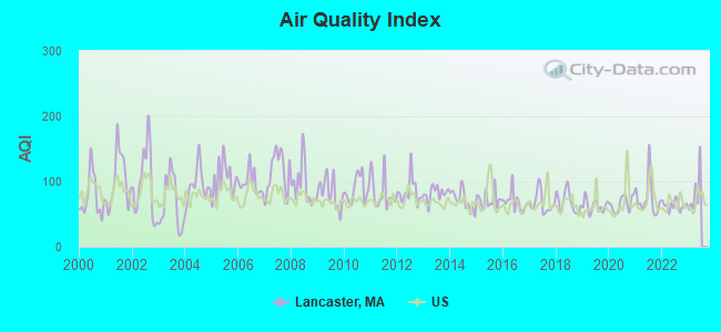
Air Quality Index (AQI) level in 2022 was 63.3. This is about average.
| City: | 63.3 |
| U.S.: | 72.6 |
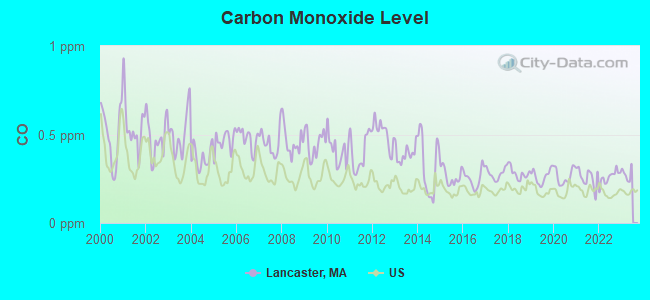
Carbon Monoxide (CO) [ppm] level in 2022 was 0.259. This is about average. Closest monitor was 15.5 miles away from the city center.
| City: | 0.259 |
| U.S.: | 0.251 |
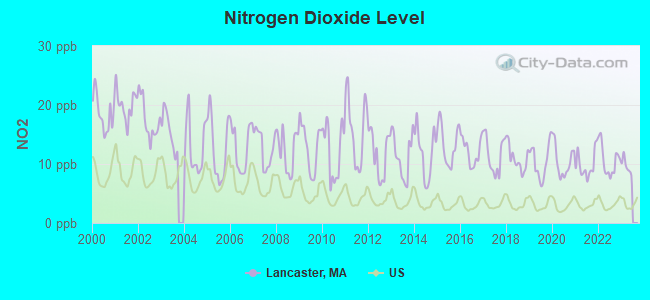
Nitrogen Dioxide (NO2) [ppb] level in 2022 was 10.6. This is significantly worse than average. Closest monitor was 7.9 miles away from the city center.
| City: | 10.6 |
| U.S.: | 5.1 |
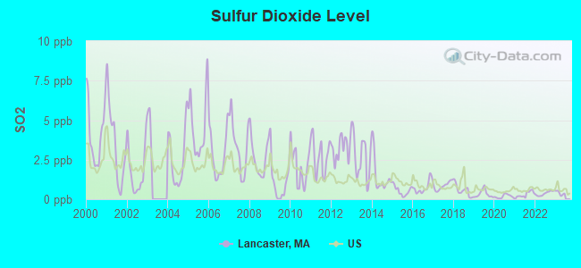
Sulfur Dioxide (SO2) [ppb] level in 2022 was 0.370. This is significantly better than average. Closest monitor was 4.7 miles away from the city center.
| City: | 0.370 |
| U.S.: | 1.515 |
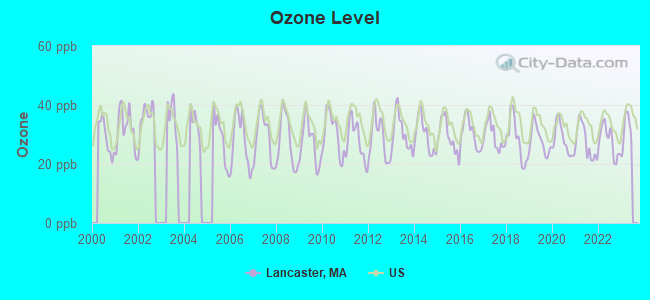
Ozone [ppb] level in 2022 was 27.8. This is about average. Closest monitor was 8.8 miles away from the city center.
| City: | 27.8 |
| U.S.: | 33.3 |
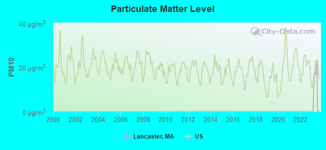
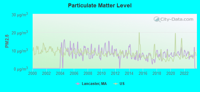
Particulate Matter (PM2.5) [µg/m3] level in 2022 was 7.80. This is about average. Closest monitor was 10.3 miles away from the city center.
| City: | 7.80 |
| U.S.: | 8.11 |
Tornado activity:
Lancaster-area historical tornado activity is slightly above Massachusetts state average. It is 22% smaller than the overall U.S. average.
On 6/9/1953, a category F4 (max. wind speeds 207-260 mph) tornado 14.3 miles away from the Lancaster town center killed 90 people and injured 1228 people and caused between $50,000,000 and $500,000,000 in damages.
On 10/3/1970, a category F3 (max. wind speeds 158-206 mph) tornado 10.4 miles away from the town center killed one person and caused between $50,000 and $500,000 in damages.
Earthquake activity:
Lancaster-area historical earthquake activity is significantly above Massachusetts state average. It is 72% smaller than the overall U.S. average.On 10/7/1983 at 10:18:46, a magnitude 5.3 (5.1 MB, 5.3 LG, 5.1 ML, Class: Moderate, Intensity: VI - VII) earthquake occurred 169.0 miles away from Lancaster center
On 4/20/2002 at 10:50:47, a magnitude 5.3 (5.3 ML, Depth: 3.0 mi) earthquake occurred 173.8 miles away from the city center
On 4/20/2002 at 10:50:47, a magnitude 5.2 (5.2 MB, 4.2 MS, 5.2 MW, 5.0 MW) earthquake occurred 173.0 miles away from Lancaster center
On 1/19/1982 at 00:14:42, a magnitude 4.7 (4.5 MB, 4.7 MD, 4.5 LG, Class: Light, Intensity: IV - V) earthquake occurred 71.2 miles away from Lancaster center
On 10/16/2012 at 23:12:25, a magnitude 4.7 (4.7 ML, Depth: 10.0 mi) earthquake occurred 93.3 miles away from the city center
On 8/22/1992 at 12:20:32, a magnitude 4.8 (4.8 MB, 3.8 MS, 4.7 LG, Depth: 6.2 mi) earthquake occurred 243.4 miles away from the city center
Magnitude types: regional Lg-wave magnitude (LG), body-wave magnitude (MB), duration magnitude (MD), local magnitude (ML), surface-wave magnitude (MS), moment magnitude (MW)
Natural disasters:
The number of natural disasters in Worcester County (27) is a lot greater than the US average (15).Major Disasters (Presidential) Declared: 15
Emergencies Declared: 12
Causes of natural disasters: Floods: 9, Storms: 8, Hurricanes: 6, Snowstorms: 5, Winter Storms: 4, Blizzards: 2, Snows: 2, Fire: 1, Heavy Rain: 1, Snowfall: 1, Tornado: 1, Wind: 1 (Note: some incidents may be assigned to more than one category).
Hospitals and medical centers in Lancaster:
- KINDRED NURSING AND REHABILITATION-RIVER TERRACE (1675 NORTH MAIN STREET)
- RIVER TERRACE HEALTHCARE NURS HOME (BALLARD HILL RD)
Other hospitals and medical centers near Lancaster:
- CLINTON HOSPITAL ASSOCIATION Acute Care Hospitals (about 4 miles away; CLINTON, MA)
- CLINTON MANOR NURSING HOME (Nursing Home, about 5 miles away; CLINTON, MA)
- PRESENTATION HEALTH CARE CENTER (Nursing Home, about 6 miles away; LEOMINSTER, MA)
- HEALTH ALLIANCE HOSP LEOMINSTER CAMPUS (Hospital, about 7 miles away; LEOMINSTER, MA)
- HEALTHALLIANCE HOSPITALS, INC Acute Care Hospitals (about 7 miles away; LEOMINSTER, MA)
- HEALTHALLIANCE HOME HEALTH AND HOSPICE (Home Health Center, about 7 miles away; LEOMINSTER, MA)
- DIVERSIFIED HOME SERVICES HOSPICE PROGRAM (Hospital, about 7 miles away; LEOMINSTER, MA)
Amtrak stations near Lancaster:
- 16 miles: WORCESTER (WORCHESTER, 45 SHREWSBURY ST.) . Services: ticket office, fully wheelchair accessible, enclosed waiting area, public restrooms, public payphones, vending machines, free short-term parking, free long-term parking, call for taxi service, public transit connection.
- 19 miles: FRAMINGHAM (443 WAVERLY ST.) . Services: public payphones, snack bar, paid short-term parking, taxi stand, public transit connection.
Colleges/universities with over 2000 students nearest to Lancaster:
- Fitchburg State University (about 10 miles; Fitchburg, MA; Full-time enrollment: 5,010)
- Quinsigamond Community College (about 13 miles; Worcester, MA; FT enrollment: 5,877)
- Assumption College (about 15 miles; Worcester, MA; FT enrollment: 2,580)
- Worcester Polytechnic Institute (about 16 miles; Worcester, MA; FT enrollment: 3,930)
- Worcester State University (about 17 miles; Worcester, MA; FT enrollment: 5,426)
- Clark University (about 18 miles; Worcester, MA; FT enrollment: 3,687)
- Framingham State University (about 18 miles; Framingham, MA; FT enrollment: 5,743)
Private high schools in Lancaster:
- DOCTOR FRANKLIN PERKINS SCHOOL (Students: 131, Location: 971 MAIN ST, Grades: UG-12)
- TRIVIUM SCHOOL (Students: 76, Location: 471 LANGEN RD, Grades: 7-12)
- RFK LANCASTER SCHOOL (Students: 37, Location: 220 OLD COMMON RD, Grades: 2-12)
- NEW RIVER ACADEMY (Students: 9, Location: 220 OLD COMMON RD CAMPBELL BUILDING, Grades: 9-12, Boys only)
Public elementary/middle schools in Lancaster:
- MARY ROWLANDSON ELEMENTARY (Students: 501, Location: 103 HOLLYWOOD DRIVE, Grades: PK-5)
- LUTHER BURBANK MIDDLE SCHOOL (Students: 237, Location: 1 HOLLYWOOD DRIVE, Grades: 6-8)
Private elementary/middle school in Lancaster:
Points of interest:
Notable locations in Lancaster: Apple Lane Orchard (A), Deershorn Farm (B), YMCA Day Camp (C), Lancaster Ambulance Service (D), Lancaster Fire Department (E), Lancaster Fire Department Station 1 Headquarters (F), Lancaster Town Hall (G), Lancaster Historical Commission Library (H), G Eric Jones Library (I), Department of Corrections Pre-Release Center (J). Display/hide their locations on the map
Churches in Lancaster include: Convent of the Cenacle (A), First Church of Christ (B), Evangelical Congregational Church (C). Display/hide their locations on the map
Cemeteries: North Village Cemetery (1), Old Settlers Cemetery (2), Middle Cemetery (3), Saint Johns Cemetery (4), Brick Tavern Cemetery (5), Saint Johns Cemetery (6), Village Cemetery (7). Display/hide their locations on the map
Lakes and reservoirs: Cranberry Pond (A), Little Spectacle Pond (B), Oak Hill Pond (C), Spectacle Pond (D), Turner Pond (E), Bartlett Pond (F), Four Ponds (G), Fort Pond (H). Display/hide their locations on the map
Streams, rivers, and creeks: Goodridge Brook (A), McGovern Brook (B), Ponakin Brook (C), South Meadow Brook (D), Spectacle Brook (E), Still River (F), Ropers Brook (G), North Nashua River (H). Display/hide their locations on the map
Parks in Lancaster include: Lancaster State Forest (1), Fiske Hill National Park (2). Display/hide their locations on the map
Birthplace of: Charles F. Chandler - Chemist, Henrietta Swan Leavitt - Astronomer, Luther Burbank - (1849-1926), biologist, botanist, Edward E. Willard - Politician, Ezra Butler - Politician, Julia Abigail Fletcher Carney - Poet.
Drinking water stations with addresses in Lancaster and their reported violations in the past:
LANCASTER WATER DEPARTMENT (Population served: 6,000, Groundwater):Past health violations:
- MCL, Monthly (TCR) - In JUN-2014, Contaminant: Coliform. Follow-up actions: St AO (w/o penalty) issued (JUL-10-2014), St Compliance achieved (JUL-10-2014)
- MCL, Monthly (TCR) - In DEC-2013, Contaminant: Coliform. Follow-up actions: St AO (w/o penalty) issued (FEB-21-2014)
- MCL, Monthly (TCR) - In AUG-2013, Contaminant: Coliform. Follow-up actions: St AO (w/o penalty) issued (OCT-09-2013)
- MCL, Monthly (TCR) - In AUG-2012, Contaminant: Coliform. Follow-up actions: St AO (w/o penalty) issued (SEP-28-2012), St Compliance achieved (SEP-28-2012)
- MCL, Monthly (TCR) - In JUN-2011, Contaminant: Coliform. Follow-up actions: St AO (w/o penalty) issued (JUL-22-2011), St Compliance achieved (JUL-22-2011)
- MCL, Monthly (TCR) - In SEP-2010, Contaminant: Coliform. Follow-up actions: St AO (w/o penalty) issued (OCT-28-2010), St Compliance achieved (OCT-28-2010)
- 2 other older health violations
| This town: | 2.7 people |
| Massachusetts: | 2.5 people |
| This town: | 73.0% |
| Whole state: | 63.0% |
| This town: | 5.0% |
| Whole state: | 7.0% |
Likely homosexual households (counted as self-reported same-sex unmarried-partner households)
- Lesbian couples: 0.5% of all households
- Gay men: 0.4% of all households
| This town: | 4.1% |
| Whole state: | 9.3% |
| This town: | 2.2% |
| Whole state: | 4.4% |
People in group quarters in Lancaster in 2010:
- 1,259 people in state prisons
- 176 people in college/university student housing
- 123 people in residential treatment centers for juveniles (non-correctional)
- 80 people in nursing facilities/skilled-nursing facilities
- 11 people in correctional facilities intended for juveniles
- 8 people in group homes intended for adults
People in group quarters in Lancaster in 2000:
- 1,169 people in state prisons
- 312 people in college dormitories (includes college quarters off campus)
- 82 people in nursing homes
- 52 people in homes for abused, dependent, and neglected children
- 19 people in other nonhousehold living situations
- 7 people in other group homes
For population 15 years and over in Lancaster:
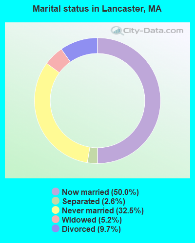
- Never married: 32.5%
- Now married: 50.0%
- Separated: 2.6%
- Widowed: 5.2%
- Divorced: 9.7%
For population 25 years and over in Lancaster:
- High school or higher: 82.2%
- Bachelor's degree or higher: 30.9%
- Graduate or professional degree: 12.0%
- Unemployed: 2.1%
- Mean travel time to work (commute): 26.2 minutes
| Here: | 12.2 |
| Massachusetts average: | 13.1 |


Graphs represent county-level data. Detailed 2008 Election Results
Religion statistics for Lancaster, MA (based on Worcester County data)


| Religion | Adherents | Congregations |
|---|---|---|
| Catholic | 306,925 | 118 |
| Mainline Protestant | 43,326 | 171 |
| Evangelical Protestant | 37,511 | 203 |
| Other | 18,931 | 69 |
| Orthodox | 7,935 | 15 |
| Black Protestant | 497 | 6 |
| None | 383,427 | - |
Food Environment Statistics:
| This county: | 1.73 / 10,000 pop. |
| Massachusetts: | 1.98 / 10,000 pop. |
| This county: | 0.05 / 10,000 pop. |
| Massachusetts: | 0.05 / 10,000 pop. |
| This county: | 1.79 / 10,000 pop. |
| State: | 2.22 / 10,000 pop. |
| Here: | 2.22 / 10,000 pop. |
| Massachusetts: | 1.77 / 10,000 pop. |
| This county: | 7.27 / 10,000 pop. |
| Massachusetts: | 8.76 / 10,000 pop. |
| Worcester County: | 8.0% |
| State: | 8.1% |
| Worcester County: | 24.0% |
| State: | 22.5% |
| Worcester County: | 16.6% |
| Massachusetts: | 16.5% |
4.71% of this county's 2021 resident taxpayers lived in other counties in 2020 ($76,229 average adjusted gross income)
| Here: | 4.71% |
| Massachusetts average: | 6.35% |
0.02% of residents moved from foreign countries ($100 average AGI)
Worcester County: 0.02% Massachusetts average: 0.01%
Top counties from which taxpayers relocated into this county between 2020 and 2021:
| from Middlesex County, MA | |
| from Norfolk County, MA | |
| from Suffolk County, MA |
4.84% of this county's 2020 resident taxpayers moved to other counties in 2021 ($87,252 average adjusted gross income)
| Here: | 4.84% |
| Massachusetts average: | 7.18% |
0.03% of residents moved to foreign countries ($199 average AGI)
Worcester County: 0.03% Massachusetts average: 0.02%
Top counties to which taxpayers relocated from this county between 2020 and 2021:
| to Middlesex County, MA | |
| to Norfolk County, MA | |
| to Suffolk County, MA |
Businesses in Lancaster, MA
- Nissan: 1
- Toyota: 1
- UPS: 1
Strongest AM radio stations in Lancaster:
- WCRN (830 AM; 50 kW; WORCESTER, MA; Owner: CARTER BROADCASTING CORPORATION)
- WKOX (1200 AM; 50 kW; FRAMINGHAM, MA; Owner: CAPSTAR TX LIMITED PARTNERSHIP)
- WRKO (680 AM; 50 kW; BOSTON, MA; Owner: ENTERCOM BOSTON LICENSE, LLC)
- WBIX (1060 AM; 40 kW; NATICK, MA; Owner: LANGER BROADCASTING CORPORATION)
- WAZN (1470 AM; 7 kW; MARLBOROUGH, MA; Owner: MULTICULTURAL RADIO BROADCASTING, INC.)
- WEEI (850 AM; 50 kW; BOSTON, MA; Owner: ENTERCOM BOSTON LICENSE, LLC)
- WAMG (890 AM; 25 kW; DEDHAM, MA; Owner: MEGA COMMUNICATIONS OF DEDHAM LICENSEE, LLC)
- WTAG (580 AM; 5 kW; WORCESTER, MA; Owner: CAPSTAR TX LIMITED PARTNERSHIP)
- WWZN (1510 AM; 50 kW; BOSTON, MA; Owner: ROSE CITY RADIO CORPORATION)
- WVNE (760 AM; daytime; 25 kW; LEICESTER, MA; Owner: BLOUNT MASSCOM, INC.)
- WCMX (1000 AM; daytime; 1 kW; LEOMINSTER, MA; Owner: TWIN CITY BAPTIST TEMPLE, INC.)
- WALE (990 AM; 50 kW; GREENVILLE, RI; Owner: NORTH AMERICAN BROADCASTING CO., INC.)
- WRCA (1330 AM; 25 kW; WALTHAM, MA; Owner: WRCA LICENSE, LLC)
Strongest FM radio stations in Lancaster:
- WXLO (104.5 FM; FITCHBURG, MA; Owner: CITADEL BROADCASTING COMPANY)
- WAAF (107.3 FM; WORCESTER, MA; Owner: ENTERCOM BOSTON LICENSE, LLC)
- WSRS (96.1 FM; WORCESTER, MA; Owner: CAPSTAR TX LIMITED PARTNERSHIP)
- WBMX (98.5 FM; BOSTON, MA; Owner: INFINITY RADIO OPERATIONS INC.)
- WFEX (92.1 FM; PETERBOROUGH, NH; Owner: FNX BROADCASTING OF NEW HAMPSHIRE LLC)
- WJMN (94.5 FM; BOSTON, MA; Owner: AMFM RADIO LICENSES, L.L.C.)
- WCRB (102.5 FM; WALTHAM, MA; Owner: CHARLES RIVER BROADCASTING WCRB LICE)
- WTKK (96.9 FM; BOSTON, MA; Owner: GREATER BOSTON RADIO, INC.)
- WROR-FM (105.7 FM; FRAMINGHAM, MA; Owner: GREATER BOSTON RADIO, INC.)
- WBOS (92.9 FM; BROOKLINE, MA; Owner: GREATER BOSTON RADIO, INC.)
- WGBH (89.7 FM; BOSTON, MA; Owner: WGBH EDUCATIONAL FOUNDATION)
- WBUR-FM (90.9 FM; BOSTON, MA; Owner: TRUSTEES OF BOSTON UNIVERSITY)
- WXKS-FM (107.9 FM; MEDFORD, MA; Owner: AMFM RADIO LICENSES, L.L.C.)
- WODS (103.3 FM; BOSTON, MA; Owner: INFINITY BROADCASTING OPERATIONS, INC.)
- WMJX (106.7 FM; BOSTON, MA; Owner: GREATER BOSTON RADIO, INC.)
- WICN (90.5 FM; WORCESTER, MA; Owner: WICN PUBLIC RADIO, INC)
- WGIR-FM (101.1 FM; MANCHESTER, NH; Owner: CAPSTAR TX LIMITED PARTNERSHIP)
- WKLB-FM (99.5 FM; LOWELL, MA; Owner: GREATER BOSTON RADIO, INC.)
- WQLL (96.5 FM; BEDFORD, NH; Owner: SAGA COMMUNICATIONS OF NEW ENGLAND, LLC)
- WHOB (106.3 FM; NASHUA, NH; Owner: TELE-MEDIA COMPANY OF NEW HAMPSHIRE, L.L.C.)
TV broadcast stations around Lancaster:
- WUNI (Channel 27; WORCESTER, MA; Owner: ENTRAVISION HOLDINGS, LLC)
- WUTF (Channel 66; MARLBOROUGH, MA; Owner: TELEFUTURA BOSTON LLC)
- WCVB-TV (Channel 5; BOSTON, MA; Owner: WCVB HEARST-ARGYLE TV, INC.)
- WGBH-TV (Channel 2; BOSTON, MA; Owner: WGBH EDUCATIONAL FOUNDATION)
- WHDH-TV (Channel 7; BOSTON, MA; Owner: WHDH-TV)
- WMFP (Channel 62; LAWRENCE, MA; Owner: WSAH LICENSE, INC.)
- WBZ-TV (Channel 4; BOSTON, MA; Owner: VIACOM INC.)
- WGBX-TV (Channel 44; BOSTON, MA; Owner: WGBH EDUCATIONAL FOUNDATION)
- WSBK-TV (Channel 38; BOSTON, MA; Owner: VIACOM INC.)
- WLVI-TV (Channel 56; CAMBRIDGE, MA; Owner: WLVI, INC.)
- WFXT (Channel 25; BOSTON, MA; Owner: FOX TELEVISION STATIONS INC.)
- W40BO (Channel 40; BOSTON, MA; Owner: PAXSON COMMUNICATIONS LPTV, INC.)
- WBPX (Channel 68; BOSTON, MA; Owner: PAXSON BOSTON-68 LICENSE, INC.)
- WYDN (Channel 48; WORCESTER, MA; Owner: EDUCATIONAL PUBLIC TV CORPORATION)
- WFXZ-CA (Channel 24; BOSTON, MA; Owner: BOSTON BROADCASTING CORP.)
- WTMU-LP (Channel 32; BOSTON, MA; Owner: ZGS BOSTON, INC.)
- WCEA-LP (Channel 58; BOSTON, MA; Owner: CHANNEL 19 TV CORPORATION)
- WNDS (Channel 50; DERRY, NH; Owner: CTV OF DERRY, INC)
- WWDP (Channel 46; NORWELL, MA; Owner: NORWELL TELEVISION, LLC)
- WCRN-LP (Channel 34; LEICESTER, MA; Owner: CARTER BROADCASTING CORPORATION)
- National Bridge Inventory (NBI) Statistics
- 21Number of bridges
- 233ft / 70.8mTotal length
- $45,166,000Total costs
- 560,281Total average daily traffic
- 43,050Total average daily truck traffic
- New bridges - historical statistics
- 11920-1929
- 11930-1939
- 111950-1959
- 51970-1979
- 21990-1999
- 12000-2009
FCC Registered Antenna Towers:
31 (See the full list of FCC Registered Antenna Towers in Lancaster)FCC Registered Broadcast Land Mobile Towers:
10 (See the full list of FCC Registered Broadcast Land Mobile Towers in Lancaster, MA)FCC Registered Microwave Towers:
3- Lancaster, 696 Fort Pond Road (Lat: 42.519861 Lon: -71.670556), Type: Mast, Structure height: 48.8 m, Overall height: 50 m, Call Sign: WPOM207,
Assigned Frequencies: 10556.2 MHz, Grant Date: 02/10/2009, Expiration Date: 04/01/2019, Cancellation Date: 09/08/2016, Certifier: Carol L Tacker, Registrant: At&t Mobility LLC, 1120 20th Street, Nw - Suite 1000, Washington, DC 20036, Phone: (202) 457-2055, Fax: (202) 457-3073, Email:
- lancaster, Lat: 42.479167 Lon: -71.716944, Call Sign: WQCX232, Licensee ID: L00031879,
Assigned Frequencies: 956.268 MHz, Grant Date: 06/15/2005, Expiration Date: 06/15/2015, Cancellation Date: 08/15/2015, Certifier: John Sonia, Registrant: Town Of Lancaster
- 4WL0792A, 2176 Main Street (Lat: 42.481972 Lon: -71.703806), Type: Mtower, Structure height: 45.7 m, Overall height: 47.8 m, Call Sign: WRAH714,
Assigned Frequencies: 10935.0 MHz, 10935.0 MHz, 10935.0 MHz, 10935.0 MHz, 10935.0 MHz, 10935.0 MHz, 10935.0 MHz, 10935.0 MHz, Grant Date: 11/21/2017, Expiration Date: 11/21/2027, Cancellation Date: 10/15/2018, Certifier: David Werblow, Registrant: T-Mobile Usa, Inc., 12920 Se 38th Street, Bellevue, WA 98006, Phone: (425) 383-8401, Fax: (425) 383-4040, Email:
FCC Registered Amateur Radio Licenses:
45 (See the full list of FCC Registered Amateur Radio Licenses in Lancaster)FAA Registered Aircraft:
6- Aircraft: BELLANCA 8GCBC (Category: Land, Seats: 3, Weight: Up to 12,499 Pounds, Speed: 101 mph), Engine: LYCOMING O&VO-360 SER (180 HP) (Reciprocating)
N-Number: 2547Z, N2547Z, N-2547Z, Serial Number: 261-78, Year manufactured: 1978, Airworthiness Date: 01/27/1978, Certificate Issue Date: 06/13/2002
Registrant (Partnership): Francesca Lecompte, 451 Sterling St, Lancaster, MA 01523, Other Owners: Kevin J Lecompte - Aircraft: PIPER PA-28-181 (Category: Land, Seats: 4, Weight: Up to 12,499 Pounds, Speed: 105 mph), Engine: LYCOMING O&VO-360 SER (180 HP) (Reciprocating)
N-Number: 38250, N38250, N-38250, Serial Number: 28-7790531, Year manufactured: 1977, Airworthiness Date: 06/01/1977, Certificate Issue Date: 08/07/1985
Registrant (Co-Owned): John H Elkins, C/O Kileen Burgoyne / 122a Rigby Rd, Lancaster, MA 01523, Other Owners: Kathleen C Elkins - Aircraft: CESSNA 182L (Category: Land, Seats: 4, Weight: Up to 12,499 Pounds, Speed: 119 mph), Engine: CONT MOTOR O-470 SERIES (230 HP) (Reciprocating)
N-Number: 42655, N42655, N-42655, Serial Number: 18259126, Year manufactured: 1968, Airworthiness Date: 12/18/1968, Certificate Issue Date: 06/30/2016
Registrant (Individual): Pamela M Hawes, 1080 George Hill Rd, Lancaster, MA 01523 - Aircraft: BEECH B35 (Category: Land, Seats: 4, Weight: Up to 12,499 Pounds, Speed: 120 mph), Engine: CONT MOTOR E185 SERIES (205 HP) (Reciprocating)
N-Number: 5191C, N5191C, N-5191C, Serial Number: D-2473, Year manufactured: 1950, Airworthiness Date: 07/07/1956, Certificate Issue Date: 04/28/2016
Registrant (Individual): Glenn J Decosta, 1786 Shirley Rd, Lancaster, MA 01523 - Aircraft: CESSNA 150F (Category: Land, Seats: 2, Weight: Up to 12,499 Pounds, Speed: 90 mph), Engine: CONT MOTOR 0-200 SERIES (100 HP) (Reciprocating)
N-Number: 6834F, N6834F, N-6834F, Serial Number: 15063434, Year manufactured: 1966, Airworthiness Date: 03/08/1966, Certificate Issue Date: 07/10/2012
Registrant (Individual): Kevin J Lecompte, 451 Sterling St, Lancaster, MA 01523 - Aircraft: STINSON 108-2 (Category: Land, Seats: 4, Weight: Up to 12,499 Pounds, Speed: 90 mph), Engine: FRANKLIN 6A4165 SERIES (165 HP) (Reciprocating)
N-Number: 9504K, N9504K, N-9504K, Serial Number: 108-2504, Year manufactured: 1947, Airworthiness Date: 03/13/1956, Certificate Issue Date: 08/12/1995
Registrant (Individual): Kevin J Lecompte, 451 Sterling St, Lancaster, MA 01523
2002 - 2018 National Fire Incident Reporting System (NFIRS) incidents
- Fire incident types reported to NFIRS in Lancaster, MA
- 18145.9%Structure Fires
- 12331.2%Outside Fires
- 6717.0%Mobile Property/Vehicle Fires
- 235.8%Other
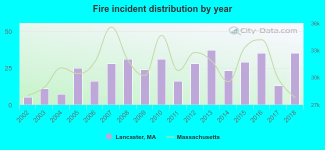 According to the data from the years 2002 - 2018 the average number of fire incidents per year is 23. The highest number of fire incidents - 37 took place in 2013, and the least - 5 in 2002. The data has a rising trend.
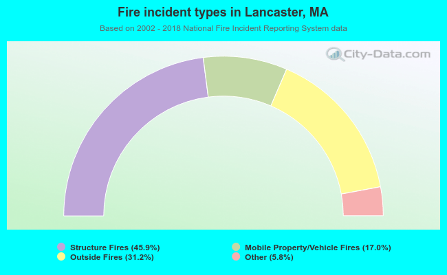 When looking into fire subcategories, the most incidents belonged to: Structure Fires (45.9%), and Outside Fires (31.2%).
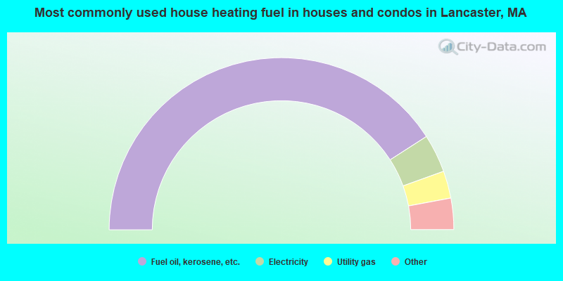
- 81.8%Fuel oil, kerosene, etc.
- 7.2%Electricity
- 5.1%Utility gas
- 3.6%Wood
- 1.9%Bottled, tank, or LP gas
- 0.4%Coal or coke
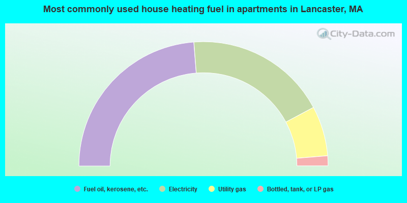
- 47.6%Fuel oil, kerosene, etc.
- 36.9%Electricity
- 13.0%Utility gas
- 2.6%Bottled, tank, or LP gas
Lancaster compared to Massachusetts state average:
- Unemployed percentage significantly below state average.
- Foreign-born population percentage significantly below state average.
- Renting percentage below state average.
- Length of stay since moving in significantly above state average.
- Number of rooms per house significantly below state average.
- House age significantly below state average.
- Institutionalized population percentage significantly above state average.
Lancaster on our top lists:
- #9 on the list of "Top 101 cities with largest percentage of females in industries: rail transportation (population 5,000+)"
- #18 on the list of "Top 101 cities with largest percentage of females in industries: data processing, libraries, and other information services (population 5,000+)"
- #19 on the list of "Top 101 cities with largest percentage of males in occupations: counselors, social workers, and other community and social service specialists (population 5,000+)"
- #21 on the list of "Top 101 cities with largest percentage of females in occupations: other health diagnosing and treating practitioners and technical occupations (population 5,000+)"
- #23 on the list of "Top 101 cities with largest percentage of females in occupations: computer specialists (population 5,000+)"
- #24 on the list of "Top 101 cities with largest percentage of males in industries: radio, tv, and computer stores (population 5,000+)"
- #29 on the list of "Top 101 cities with largest percentage of males in industries: plastics and rubber products (population 5,000+)"
- #30 on the list of "Top 101 cities with largest percentage of females in occupations: art and design workers (population 5,000+)"
- #31 on the list of "Top 101 cities with largest percentage of males in industries: computer and electronic products (population 5,000+)"
- #32 on the list of "Top 101 cities with largest percentage of males in industries: machinery, equipment, and supplies merchant wholesalers (population 5,000+)"
- #36 on the list of "Top 101 cities with largest percentage of males in industries: printing and related support activities (population 5,000+)"
- #38 on the list of "Top 101 cities with largest percentage of females in industries: printing and related support activities (population 5,000+)"
- #38 on the list of "Top 101 cities with the largest percentage of people in homes for abused, dependent, and neglected children (population 1,000+)"
- #39 on the list of "Top 101 cities with largest percentage of males in industries: retail florists (population 5,000+)"
- #41 on the list of "Top 101 cities with largest percentage of males in industries: petroleum and petroleum products merchant wholesalers (population 5,000+)"
- #46 on the list of "Top 101 cities with largest percentage of females in occupations: librarians, curators, and archivists (population 5,000+)"
- #47 on the list of "Top 101 cities with largest percentage of males in occupations: other teachers and instructors, education, training, and library occupations (population 5,000+)"
- #48 on the list of "Top 101 cities with largest percentage of males in industries: professional and commercial equipment and supplies merchant wholesalers (population 5,000+)"
- #51 on the list of "Top 101 cities with the most residents born in Other Central America (population 500+)"
- #56 on the list of "Top 101 cities with largest percentage of males in industries: petroleum and coal products (population 5,000+)"
- #4 on the list of "Top 101 counties with the highest carbon monoxide air pollution readings in 2012 (ppm)"
- #5 on the list of "Top 101 counties with the most Catholic congregations"
- #12 on the list of "Top 101 counties with the highest surface withdrawal of fresh water for public supply"
- #16 on the list of "Top 101 counties with the highest total withdrawal of fresh water for public supply"
- #23 on the list of "Top 101 counties with the highest Sulfur Oxides Annual air pollution readings in 2012 (µg/m3)"

|
|
Total of 191 patent applications in 2008-2024.