Francestown, New Hampshire
Submit your own pictures of this town and show them to the world
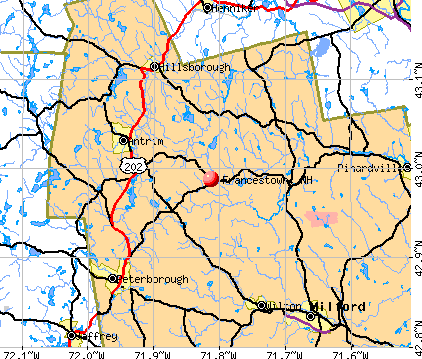
- OSM Map
- General Map
- Google Map
- MSN Map
Population change since 2000: +5.5%
 |
| Males: 789 | |
| Females: 773 |
| Median resident age: | 47.5 years |
| New Hampshire median age: | 43.9 years |
Zip codes: 03043.
| Francestown: | $116,665 |
| NH: | $89,992 |
Estimated per capita income in 2022: $57,719 (it was $28,942 in 2000)
Francestown town income, earnings, and wages data
Estimated median house or condo value in 2022: $440,581 (it was $146,500 in 2000)
| Francestown: | $440,581 |
| NH: | $384,700 |
Mean prices in 2022: all housing units: $411,252; detached houses: $441,251; townhouses or other attached units: $283,002; in 2-unit structures: $347,377; in 3-to-4-unit structures: $666,663; in 5-or-more-unit structures: $275,798; mobile homes: $132,093
Detailed information about poverty and poor residents in Francestown, NH
Compare current foreclosures near Francestown, NH:
| Photo | Address | Area | Beds / Baths | Price | Details |
|---|---|---|---|---|---|

|
#1
Nashua St
Milford, NH 03055
|
2,172 sq. feet
|
2 baths 4 beds |
show details | |

|
#2
Blucher St
Manchester, NH 03102
|
2,448 sq. feet
|
2 baths 3 beds |
show details | |

|
#3
Amherst St
Amherst, NH 03031
|
- sq. feet
|
4 baths 3 beds |
show details | |

|
#4
Arnold St
Manchester, NH 03102
|
1,792 sq. feet
|
1 baths 4 beds |
show details | |

|
#5
Holbrook Rd
Bedford, NH 03110
|
3,376 sq. feet
|
2 baths 4 beds |
show details | |

|
#6
Cypress Rd
Milford, NH 03055
|
1,929 sq. feet
|
1 baths 3 beds |
show details | |

|
#7
Courthouse Rd
Amherst, NH 03031
|
1,391 sq. feet
|
1 baths 3 beds |
show details | |

|
#8
Portage Rd
Goffstown, NH 03045
|
1,886 sq. feet
|
1 baths 3 beds |
show details | |

|
#9
Etta Ln
Weare, NH 03281
|
1,425 sq. feet
|
1 baths 3 beds |
show details | |

|
#10
Diamond Ln
Goffstown, NH 03045
|
2,464 sq. feet
|
1 baths 4 beds |
show details |
| Photo | Address | Area | Beds / Baths | Price | Details |
|---|---|---|---|---|---|

|
#11
Northfield Rd
Amherst, NH 03031
|
1,688 sq. feet
|
1 baths 3 beds |
show details | |

|
#12
Moose Club Park Rd
Goffstown, NH 03045
|
1,864 sq. feet
|
2 baths 4 beds |
show details | |

|
#13
Mill St
Greenville, NH 03048
|
1,201 sq. feet
|
2 baths 2 beds |
show details | |

|
#14
Ridgefield Dr
Milford, NH 03055
|
1,357 sq. feet
|
1 baths 3 beds |
show details | |

|
#15
Channel Ln
Goffstown, NH 03045
|
812 sq. feet
|
1 baths 2 beds |
show details | |

|
#16
Pinard St
Manchester, NH 03102
|
2,028 sq. feet
|
2 baths 5 beds |
show details | |

|
#17
Van Ger Dr
Bow, NH 03304
|
2,498 sq. feet
|
2 baths 3 beds |
show details | |

|
#18
Dunnington Way
Bedford, NH 03110
|
1,522 sq. feet
|
2 baths 4 beds |
show details | |

|
#19
Dunnington Way F/k/a 86 Gault Road
Bedford, NH Array
|
1,522 sq. feet
|
2 baths 4 beds |
show details | |

|
#20
Rockland Ave
Manchester, NH 03102
|
1,870 sq. feet
|
1 baths 3 beds |
show details |
| Photo | Address | Area | Beds / Baths | Price | Details |
|---|---|---|---|---|---|

|
#21
Wallingford Rd
Milford, NH 03055
|
2,756 sq. feet
|
2 baths 4 beds |
show details | |

|
#22
Glen Rd
Bedford, NH 03110
|
3,094 sq. feet
|
2 baths 4 beds |
show details | |

|
#23
Parker Ave
Manchester, NH 03102
|
1,352 sq. feet
|
1 baths 3 beds |
show details | |

|
#24
Olde Lantern Rd
Bedford, NH 03110
|
2,491 sq. feet
|
2 baths 4 beds |
show details | |

|
#25
Longbrook Rd
Goffstown, NH 03045
|
1,960 sq. feet
|
2 baths 3 beds |
show details | |

|
#26
Wallace Rd
Goffstown, NH 03045
|
1,848 sq. feet
|
1 baths 2 beds |
show details | |

|
#27
Hemlock St
Hillsboro, NH 03244
|
- sq. feet
|
2 baths 4 beds |
show details | |

|
#28
Blake Rd # A
Weare, NH 03281
|
- sq. feet
|
1 baths 3 beds |
show details | |

|
#29
Lakeview Dr
Weare, NH 03281
|
- sq. feet
|
2 baths 3 beds |
show details | |

|
#30
Holly Hill Farm Rd
Weare, NH 03281
|
- sq. feet
|
2 baths 3 beds |
show details |
| Photo | Address | Area | Beds / Baths | Price | Details |
|---|---|---|---|---|---|

|
#31
Mill St
New Boston, NH 03070
|
- sq. feet
|
3 baths 4 beds |
show details | |

|
#32
Curtis Farm Rd
Wilton, NH 03086
|
- sq. feet
|
1 baths 3 beds |
show details | |

|
#33
Melody Ln
Hillsboro, NH 03244
|
- sq. feet
|
1 baths 2 beds |
show details | |

|
#34
Francestown Rd
Bennington, NH 03442
|
- sq. feet
|
1 baths 2 beds |
show details | |

|
#35
Whitney Rd
Hillsboro, NH 03244
|
- sq. feet
|
2 baths 3 beds |
show details | |

|
#36
Wason St
Manchester, NH 03102
|
- sq. feet
|
- baths - beds |
show details | |

|
#37
Amory St # 1r
Manchester, NH 03102
|
- sq. feet
|
- baths - beds |
show details | |

|
#38
N Main St
Mont Vernon, NH 03057
|
- sq. feet
|
- baths - beds |
show details | |

|
#39
Agnes St Apt 308
Manchester, NH 03102
|
- sq. feet
|
- baths - beds |
show details | |

|
#40
Agnes St Apt 208
Manchester, NH 03102
|
- sq. feet
|
- baths - beds |
show details |
| Photo | Address | Area | Beds / Baths | Price | Details |
|---|---|---|---|---|---|

|
#41
Ski Tow Rd
Weare, NH 03281
|
- sq. feet
|
- baths - beds |
show details | |

|
#42
Gault Rd
Bedford, NH 03110
|
- sq. feet
|
- baths - beds |
show details | |

|
#43
Deering Center Rd
Hillsboro, NH 03244
|
- sq. feet
|
- baths - beds |
show details | |

|
#44
Hevey St
Manchester, NH 03102
|
- sq. feet
|
- baths - beds |
show details | |

|
#45
English Village Rd Apt 208
Manchester, NH 03102
|
- sq. feet
|
- baths - beds |
show details | |

|
#46
Goffstown Rd
Manchester, NH 03102
|
- sq. feet
|
- baths - beds |
show details | |

|
#47
Country Club Dr Apt 2
Manchester, NH 03102
|
- sq. feet
|
- baths - beds |
show details | |

|
#48
Garden Dr Apt 13
Manchester, NH 03102
|
- sq. feet
|
- baths - beds |
show details | |

|
#49
Country Club Dr Apt 29
Manchester, NH 03102
|
- sq. feet
|
- baths - beds |
show details | |

|
Check over 1 million property listings on Foreclosure.com!
|
browse all offers | |||

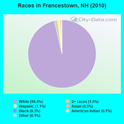
- 1,50596.4%White alone
- 241.5%Two or more races
- 171.1%Hispanic
- 80.5%Asian alone
- 40.3%Black alone
- 20.1%American Indian alone
- 20.1%Other race alone
Races in Francestown detailed stats: ancestries, foreign born residents, place of birth
According to our research of New Hampshire and other state lists, there was 1 registered sex offender living in Francestown, New Hampshire as of May 20, 2024.
The ratio of all residents to sex offenders in Francestown is 1,562 to 1.
The ratio of registered sex offenders to all residents in this city is much lower than the state average.
Full-time law enforcement employees in 2021, including police officers: 1 (1 officers - 0 male; 1 female).
| Officers per 1,000 residents here: | 0.63 |
| New Hampshire average: | 2.14 |
 Recent articles from our blog. Our writers, many of them Ph.D. graduates or candidates, create easy-to-read articles on a wide variety of topics.

 | Looking at Southern NH...Where would you recommend searching? (15 replies) |
| Moving to the Manchester Area - Advice Please :) (13 replies) |
| What Is A Good Affordable City in Southern NH (12 replies) |
| Questions about Living in NH (From CA) (12 replies) |
| Leaving New Mexico for New Hampshire in Spring (18 replies) |
| Searching for area with unique homes. (24 replies) |
Latest news from Francestown, NH collected exclusively by city-data.com from local newspapers, TV, and radio stations
Ancestries: English (25.9%), Irish (15.4%), German (11.7%), Italian (9.9%), Scottish (9.6%), French (9.5%).
Current Local Time: EST time zone
Incorporated in 1772
Elevation: 831 feet
Land area: 30.2 square miles.
Population density: 52 people per square mile (very low).
27 residents are foreign born
| This town: | 1.8% |
| New Hampshire: | 4.4% |
| Francestown town: | 2.4% ($3,514) |
| New Hampshire: | 2.3% ($2,946) |
Nearest city with pop. 50,000+: Manchester, NH  (18.1 miles , pop. 107,006).
Nearest city with pop. 200,000+: Boston, MA (58.9 miles , pop. 589,141).
Nearest city with pop. 1,000,000+: Bronx, NY (182.2 miles , pop. 1,332,650).
Nearest cities:
), ), Latitude: 42.99 N, Longitude: 71.81 W
Area code commonly used in this area: 603
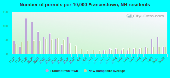
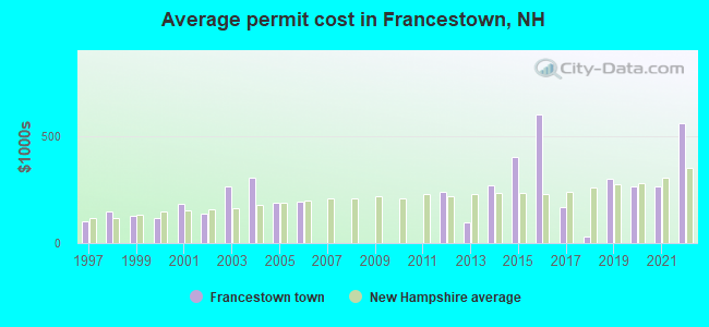
Single-family new house construction building permits:
- 2022: 4 buildings, average cost: $561,000
- 2021: 9 buildings, average cost: $265,300
- 2020: 8 buildings, average cost: $265,300
- 2019: 4 buildings, average cost: $300,000
- 2018: 3 buildings, average cost: $33,400
- 2017: 3 buildings, average cost: $166,700
- 2016: 2 buildings, average cost: $600,000
- 2015: 2 buildings, average cost: $400,000
- 2014: 3 buildings, average cost: $271,700
- 2013: 3 buildings, average cost: $98,300
- 2012: 2 buildings, average cost: $236,600
- 2006: 9 buildings, average cost: $195,100
- 2005: 5 buildings, average cost: $187,000
- 2004: 8 buildings, average cost: $305,600
- 2003: 11 buildings, average cost: $263,900
- 2002: 9 buildings, average cost: $136,100
- 2001: 12 buildings, average cost: $183,300
- 2000: 17 buildings, average cost: $118,000
- 1999: 19 buildings, average cost: $126,500
- 1998: 4 buildings, average cost: $145,000
- 1997: 7 buildings, average cost: $103,800
| Here: | 2.4% |
| New Hampshire: | 2.5% |
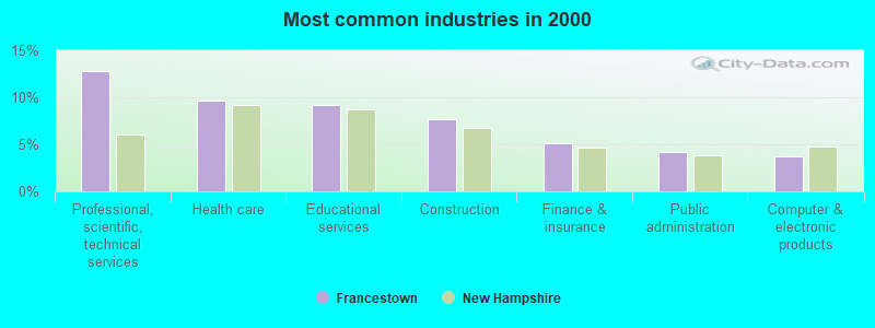
- Professional, scientific, technical services (12.8%)
- Health care (9.7%)
- Educational services (9.2%)
- Construction (7.7%)
- Finance & insurance (5.1%)
- Public administration (4.2%)
- Computer & electronic products (3.7%)
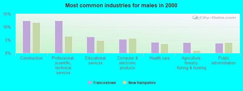
- Construction (12.5%)
- Professional, scientific, technical services (12.5%)
- Educational services (6.2%)
- Computer & electronic products (5.4%)
- Health care (4.2%)
- Agriculture, forestry, fishing & hunting (4.0%)
- Public administration (3.8%)
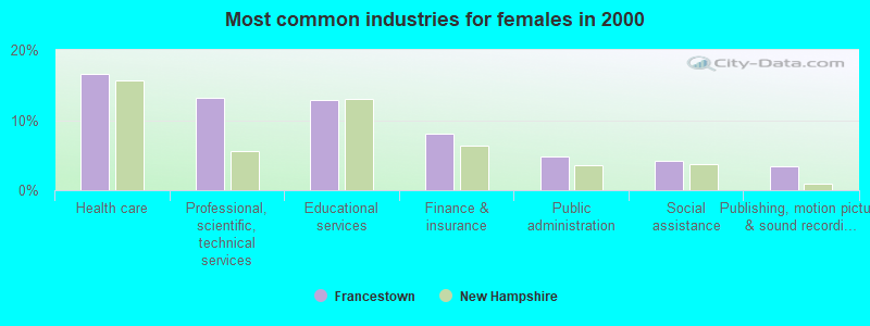
- Health care (16.5%)
- Professional, scientific, technical services (13.2%)
- Educational services (12.9%)
- Finance & insurance (8.1%)
- Public administration (4.8%)
- Social assistance (4.2%)
- Publishing, motion picture & sound recording industries (3.4%)
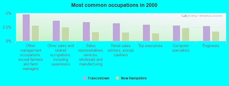
- Other management occupations, except farmers and farm managers (4.8%)
- Other sales and related occupations, including supervisors (3.7%)
- Sales representatives, services, wholesale and manufacturing (3.5%)
- Retail sales workers, except cashiers (3.2%)
- Top executives (3.0%)
- Computer specialists (2.9%)
- Engineers (2.7%)
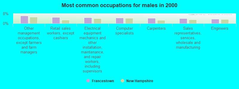
- Other management occupations, except farmers and farm managers (6.2%)
- Retail sales workers, except cashiers (5.1%)
- Electrical equipment mechanics and other installation, maintenance, and repair workers, including supervisors (4.9%)
- Computer specialists (4.7%)
- Carpenters (4.5%)
- Sales representatives, services, wholesale and manufacturing (4.2%)
- Engineers (3.6%)
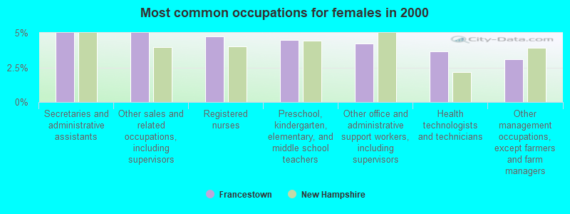
- Secretaries and administrative assistants (5.0%)
- Other sales and related occupations, including supervisors (5.0%)
- Registered nurses (4.8%)
- Preschool, kindergarten, elementary, and middle school teachers (4.5%)
- Other office and administrative support workers, including supervisors (4.2%)
- Health technologists and technicians (3.6%)
- Other management occupations, except farmers and farm managers (3.1%)
Average climate in Francestown, New Hampshire
Based on data reported by over 4,000 weather stations


(lower is better)
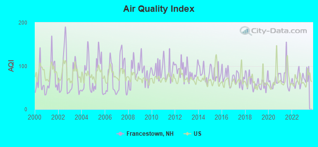
Air Quality Index (AQI) level in 2022 was 66.8. This is about average.
| City: | 66.8 |
| U.S.: | 72.6 |
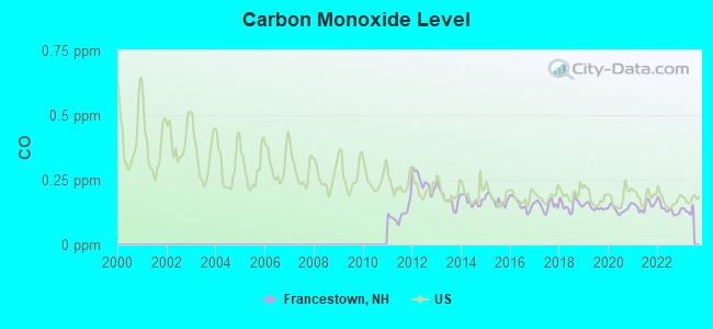
Carbon Monoxide (CO) [ppm] level in 2022 was 0.136. This is significantly better than average. Closest monitor was 9.4 miles away from the city center.
| City: | 0.136 |
| U.S.: | 0.251 |
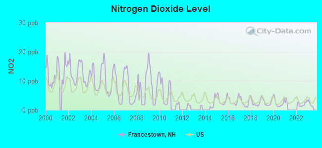
Nitrogen Dioxide (NO2) [ppb] level in 2022 was 2.05. This is significantly better than average. Closest monitor was 9.4 miles away from the city center.
| City: | 2.05 |
| U.S.: | 5.11 |
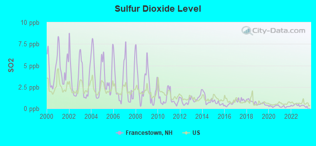
Sulfur Dioxide (SO2) [ppb] level in 2022 was 0.379. This is significantly better than average. Closest monitor was 9.4 miles away from the city center.
| City: | 0.379 |
| U.S.: | 1.515 |
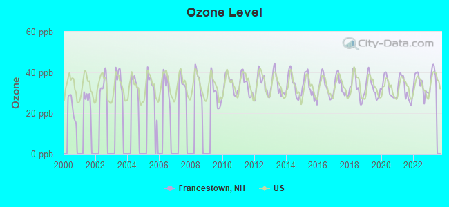
Ozone [ppb] level in 2022 was 34.1. This is about average. Closest monitor was 9.4 miles away from the city center.
| City: | 34.1 |
| U.S.: | 33.3 |
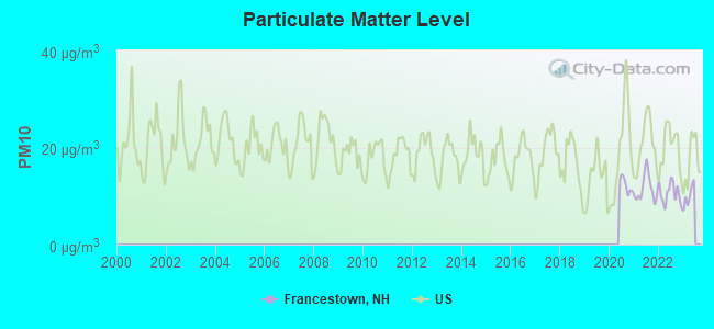
Particulate Matter (PM10) [µg/m3] level in 2022 was 10.6. This is significantly better than average. Closest monitor was 9.4 miles away from the city center.
| City: | 10.6 |
| U.S.: | 19.2 |
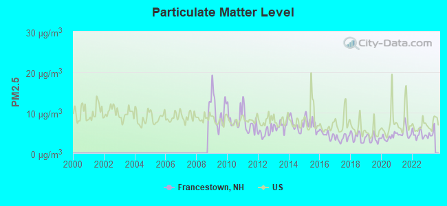
Particulate Matter (PM2.5) [µg/m3] level in 2022 was 4.58. This is significantly better than average. Closest monitor was 9.4 miles away from the city center.
| City: | 4.58 |
| U.S.: | 8.11 |
Tornado activity:
Francestown-area historical tornado activity is above New Hampshire state average. It is 32% smaller than the overall U.S. average.
On 6/9/1953, a category F4 (max. wind speeds 207-260 mph) tornado 40.2 miles away from the Francestown town center killed 90 people and injured 1228 people and caused between $50,000,000 and $500,000,000 in damages.
On 6/22/1981, a category F3 (max. wind speeds 158-206 mph) tornado 30.6 miles away from the town center injured 3 people and caused between $5000 and $50,000 in damages.
Earthquake activity:
Francestown-area historical earthquake activity is significantly above New Hampshire state average. It is 71% smaller than the overall U.S. average.On 4/20/2002 at 10:50:47, a magnitude 5.3 (5.3 ML, Depth: 3.0 mi, Class: Moderate, Intensity: VI - VII) earthquake occurred 141.5 miles away from the city center
On 10/7/1983 at 10:18:46, a magnitude 5.3 (5.1 MB, 5.3 LG, 5.1 ML) earthquake occurred 143.6 miles away from the city center
On 4/20/2002 at 10:50:47, a magnitude 5.2 (5.2 MB, 4.2 MS, 5.2 MW, 5.0 MW) earthquake occurred 140.9 miles away from Francestown center
On 1/19/1982 at 00:14:42, a magnitude 4.7 (4.5 MB, 4.7 MD, 4.5 LG, Class: Light, Intensity: IV - V) earthquake occurred 37.0 miles away from Francestown center
On 10/16/2012 at 23:12:25, a magnitude 4.7 (4.7 ML, Depth: 10.0 mi) earthquake occurred 71.8 miles away from Francestown center
On 10/2/1994 at 11:27:22, a magnitude 3.7 (3.5 LG, 3.7 LG, Depth: 6.2 mi, Class: Light, Intensity: II - III) earthquake occurred 50.3 miles away from the city center
Magnitude types: regional Lg-wave magnitude (LG), body-wave magnitude (MB), duration magnitude (MD), local magnitude (ML), surface-wave magnitude (MS), moment magnitude (MW)
Natural disasters:
The number of natural disasters in Hillsborough County (27) is a lot greater than the US average (15).Major Disasters (Presidential) Declared: 17
Emergencies Declared: 10
Causes of natural disasters: Storms: 13, Floods: 11, Winter Storms: 5, Snowstorms: 4, Hurricanes: 3, Snows: 3, Blizzard: 1, Ice Storm: 1, Snowfall: 1, Wind: 1 (Note: some incidents may be assigned to more than one category).
Hospitals and medical centers near Francestown:
- PHEASANT WOOD CARE AND REHABILIATION CENTER (Nursing Home, about 9 miles away; PETERBOROUGH, NH)
- MONADNOCK COMMUNITY HOSPITAL Critical Access Hospitals (about 10 miles away; PETERBOROUGH, NH)
- ST JOSEPH HOME AND HOSPICE CARE (Home Health Center, about 13 miles away; MILFORD, NH)
- CRESTWOOD CARE AND REHABILITATION CENTER (Nursing Home, about 13 miles away; MILFORD, NH)
- ELM'S NURSING AND REHAB CENTER (THE) (Nursing Home, about 14 miles away; MILFORD, NH)
- BEL AIR NURSING HOME (Nursing Home, about 14 miles away; GOFFSTOWN, NH)
- HILLSBOROUGH COUNTY NURSING HOME (Nursing Home, about 15 miles away; GOFFSTOWN, NH)
Colleges/universities with over 2000 students nearest to Francestown:
- Saint Anselm College (about 16 miles; Manchester, NH; Full-time enrollment: 2,059)
- Mount Washington College (about 18 miles; Manchester, NH; FT enrollment: 2,187)
- Southern New Hampshire University (about 19 miles; Manchester, NH; FT enrollment: 16,552)
- Franklin Pierce University (about 19 miles; Rindge, NH; FT enrollment: 2,139)
- NHTI-Concord's Community College (about 22 miles; Concord, NH; FT enrollment: 2,865)
- Keene State College (about 25 miles; Keene, NH; FT enrollment: 5,098)
- Fitchburg State University (about 28 miles; Fitchburg, MA; FT enrollment: 5,010)
Public elementary/middle school in Francestown:
- FRANCESTOWN ELEMENTARY SCHOOL (Students: 78, Location: 325 2ND NH TURNPIKE S., Grades: KG-4)
Points of interest:
Notable location: Francestown Volunteer Fire Department (A). Display/hide its location on the map
Churches in Francestown include: United Church of Lyndeborough (A), First Unitarian Church (B). Display/hide their locations on the map
Lakes and reservoirs: Dennison Pond (A), Haunted Lake (B), Shattuck Pond (C), Pleasant Pond (D). Display/hide their locations on the map
Streams, rivers, and creeks: Rand Brook (A), Whiting Brook (B), Dinsmore Brook (C), Collins Brook (D). Display/hide their locations on the map
Birthplace of: Sylvester H. Roper - Inventor, James Bell (New Hampshire) - Politician.
Drinking water stations with addresses in Francestown and their reported violations in the past:
FRANCESTOWN VILLAGE WATER (Population served: 150, Groundwater):Past health violations:CROTCHED MOUNTAIN MNTNC (Population served: 115, Groundwater):Past monitoring violations:
- MCL, Monthly (TCR) - In AUG-2010, Contaminant: Coliform. Follow-up actions: St Public Notif requested (AUG-30-2010), St Violation/Reminder Notice (AUG-30-2010), St Public Notif received (SEP-24-2010), St Compliance achieved (MAR-11-2011)
- MCL, Average - Between OCT-2009 and DEC-2009, Contaminant: Arsenic. Follow-up actions: St AO (w/o penalty) issued (AUG-03-2009), St Public Notif requested (DEC-04-2009), St Violation/Reminder Notice (DEC-04-2009), St Public Notif received (DEC-16-2009), St Compliance achieved (JAN-31-2012)
- MCL, Average - Between JUL-2009 and SEP-2009, Contaminant: Arsenic. Follow-up actions: St AO (w/o penalty) issued (AUG-03-2009), St Public Notif requested (NOV-06-2009), St Violation/Reminder Notice (NOV-06-2009), St Public Notif received (NOV-18-2009), St Compliance achieved (JAN-31-2012)
- MCL, Average - Between APR-2009 and JUN-2009, Contaminant: Arsenic. Follow-up actions: St Public Notif requested (JUN-02-2009), St Violation/Reminder Notice (JUN-02-2009), St Public Notif received (JUN-30-2009), St AO (w/o penalty) issued (AUG-03-2009), St Compliance achieved (JAN-31-2012)
- MCL, Average - Between JAN-2009 and MAR-2009, Contaminant: Arsenic. Follow-up actions: St Public Notif requested (MAR-31-2009), St Violation/Reminder Notice (MAR-31-2009), St Public Notif received (APR-14-2009), St AO (w/o penalty) issued (AUG-03-2009), St Compliance achieved (JAN-31-2012)
- MCL, Monthly (TCR) - In JAN-2009, Contaminant: Coliform. Follow-up actions: St Public Notif requested (JAN-29-2009), St Violation/Reminder Notice (JAN-29-2009), St Public Notif received (FEB-05-2009), St Compliance achieved (JUL-28-2009)
- 5 other older health violations
- Monitoring, Repeat Major (TCR) - In NOV-2008, Contaminant: Coliform (TCR). Follow-up actions: St Public Notif requested (JAN-05-2009), St Violation/Reminder Notice (JAN-05-2009), St Public Notif received (JAN-27-2009), St Compliance achieved (FEB-25-2009)
- One minor monitoring violation
Past health violations:Past monitoring violations:
- MCL, Monthly (TCR) - In SEP-2008, Contaminant: Coliform. Follow-up actions: St Public Notif requested (SEP-23-2008), St Violation/Reminder Notice (SEP-23-2008), St Public Notif received (OCT-06-2008), St Compliance achieved (APR-27-2009)
- Monitoring and Reporting (DBP) - Between JUL-01-2010 and OCT-01-2010, Contaminant: Chlorine. Follow-up actions: St Violation/Reminder Notice (OCT-29-2010), St Compliance achieved (MAR-16-2011)
- Follow-up Or Routine LCR Tap M/R - In OCT-01-2004, Contaminant: Lead and Copper Rule. Follow-up actions: St Public Notif requested (JAN-18-2005), St Violation/Reminder Notice (JAN-18-2005), St Compliance achieved (FEB-11-2005), St Public Notif received (FEB-23-2005)
| This town: | 2.6 people |
| New Hampshire: | 2.5 people |
| This town: | 75.7% |
| Whole state: | 66.3% |
| This town: | 6.7% |
| Whole state: | 8.3% |
Likely homosexual households (counted as self-reported same-sex unmarried-partner households)
- Lesbian couples: 0.2% of all households
- Gay men: 0.5% of all households
| This town: | 3.0% |
| Whole state: | 6.5% |
| This town: | 0.9% |
| Whole state: | 2.8% |
For population 15 years and over in Francestown:
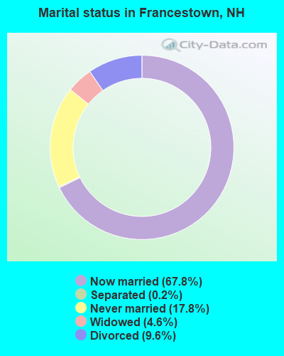
- Never married: 17.8%
- Now married: 67.8%
- Separated: 0.2%
- Widowed: 4.6%
- Divorced: 9.6%
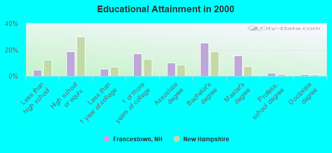
For population 25 years and over in Francestown:
- High school or higher: 95.4%
- Bachelor's degree or higher: 44.3%
- Graduate or professional degree: 19.0%
- Unemployed: 1.3%
- Mean travel time to work (commute): 39.3 minutes
| Here: | 9.6 |
| New Hampshire average: | 10.9 |


Graphs represent county-level data. Detailed 2008 Election Results
Religion statistics for Francestown, NH (based on Hillsborough County data)


| Religion | Adherents | Congregations |
|---|---|---|
| Catholic | 124,993 | 40 |
| Evangelical Protestant | 20,588 | 103 |
| Mainline Protestant | 17,794 | 60 |
| Other | 7,365 | 35 |
| Orthodox | 2,990 | 7 |
| Black Protestant | - | 1 |
| None | 226,991 | - |
Food Environment Statistics:
| Hillsborough County: | 1.82 / 10,000 pop. |
| New Hampshire: | 2.14 / 10,000 pop. |
| Here: | 0.12 / 10,000 pop. |
| New Hampshire: | 0.15 / 10,000 pop. |
| Hillsborough County: | 1.65 / 10,000 pop. |
| State: | 1.78 / 10,000 pop. |
| Hillsborough County: | 2.67 / 10,000 pop. |
| New Hampshire: | 4.02 / 10,000 pop. |
| This county: | 8.23 / 10,000 pop. |
| New Hampshire: | 9.70 / 10,000 pop. |
| This county: | 6.9% |
| New Hampshire: | 7.6% |
| This county: | 24.5% |
| New Hampshire: | 24.4% |
| Hillsborough County: | 15.1% |
| State: | 15.9% |
6.73% of this county's 2021 resident taxpayers lived in other counties in 2020 ($92,767 average adjusted gross income)
| Here: | 6.73% |
| New Hampshire average: | 7.66% |
0.01% of residents moved from foreign countries ($183 average AGI)
Hillsborough County: 0.01% New Hampshire average: 0.01%
Top counties from which taxpayers relocated into this county between 2020 and 2021:
| from Middlesex County, MA | |
| from Rockingham County, NH | |
| from Merrimack County, NH |
6.49% of this county's 2020 resident taxpayers moved to other counties in 2021 ($81,100 average adjusted gross income)
| Here: | 6.49% |
| New Hampshire average: | 6.80% |
0.02% of residents moved to foreign countries ($105 average AGI)
Hillsborough County: 0.02% New Hampshire average: 0.01%
Top counties to which taxpayers relocated from this county between 2020 and 2021:
| to Rockingham County, NH | |
| to Merrimack County, NH | |
| to Middlesex County, MA |
Strongest AM radio stations in Francestown:
- WRKO (680 AM; 50 kW; BOSTON, MA; Owner: ENTERCOM BOSTON LICENSE, LLC)
- WGIR (610 AM; 5 kW; MANCHESTER, NH; Owner: CAPSTAR TX LIMITED PARTNERSHIP)
- WCRN (830 AM; 50 kW; WORCESTER, MA; Owner: CARTER BROADCASTING CORPORATION)
- WEEI (850 AM; 50 kW; BOSTON, MA; Owner: ENTERCOM BOSTON LICENSE, LLC)
- WKBR (1250 AM; 5 kW; MANCHESTER, NH; Owner: DEVON BROADCASTING COMPANY, INC.)
- WKOX (1200 AM; 50 kW; FRAMINGHAM, MA; Owner: CAPSTAR TX LIMITED PARTNERSHIP)
- WBIX (1060 AM; 40 kW; NATICK, MA; Owner: LANGER BROADCASTING CORPORATION)
- WNNZ (640 AM; 50 kW; WESTFIELD, MA; Owner: CLEAR CHANNEL BROADCASTING LICENSES, INC.)
- WWZN (1510 AM; 50 kW; BOSTON, MA; Owner: ROSE CITY RADIO CORPORATION)
- WVNE (760 AM; daytime; 25 kW; LEICESTER, MA; Owner: BLOUNT MASSCOM, INC.)
- WFEA (1370 AM; 5 kW; MANCHESTER, NH; Owner: SAGA COMMUNICATIONS OF NEW ENGLAND, LLC)
- WBZ (1030 AM; 50 kW; BOSTON, MA; Owner: INFINITY BROADCASTING OPERATIONS, INC.)
- WDER (1320 AM; 10 kW; DERRY, NH; Owner: BLOUNT COMMUNICATIONS, INC. OF NH)
Strongest FM radio stations in Francestown:
- WFEX (92.1 FM; PETERBOROUGH, NH; Owner: FNX BROADCASTING OF NEW HAMPSHIRE LLC)
- WGIR-FM (101.1 FM; MANCHESTER, NH; Owner: CAPSTAR TX LIMITED PARTNERSHIP)
- WQLL (96.5 FM; BEDFORD, NH; Owner: SAGA COMMUNICATIONS OF NEW ENGLAND, LLC)
- WLMW (90.7 FM; MANCHESTER, NH; Owner: KNOWLEDGE FOR LIFE)
- WZID (95.7 FM; MANCHESTER, NH; Owner: SAGA COMMUNICATIONS OF NEW ENGLAND, LLC)
- WTPL (107.7 FM; HILLSBORO, NH; Owner: CONCORD BROADCASTING, L.L.C.)
- WNNH (99.1 FM; HENNIKER, NH; Owner: TELE-MEDIA COMPANY OF NEW HAMPSHIRE, L.L.C.)
- WHDQ (106.1 FM; CLAREMONT, NH; Owner: GREAT NORTHERN RADIO, L.L.C.)
- WVPR (89.5 FM; WINDSOR, VT; Owner: VERMONT PUBLIC RADIO)
- WKNE (103.7 FM; KEENE, NH; Owner: SAGA COMMUNICATIONS OF NEW ENGLAND, LLC)
- WEVN (90.7 FM; KEENE, NH; Owner: NEW HAMPSHIRE PUBLIC RADIO, INC.)
- WNHI (93.3 FM; BELMONT, NH; Owner: CONCORD BROADCASTING, L.L.C.)
- WJJR (98.1 FM; RUTLAND, VT; Owner: 6 JOHNSON ROAD LICENSES, INC.)
- WZRT (97.1 FM; RUTLAND, VT; Owner: CAPSTAR TX LIMITED PARTNERSHIP)
- WEBK (105.3 FM; KILLINGTON, VT; Owner: 6 JOHNSON ROAD LICENSES, INC.)
- WEQX (102.7 FM; MANCHESTER, VT; Owner: NORTHSHIRE COMMUNICATIONS, INC.)
- WSCY (106.9 FM; MOULTONBOROUGH, NH; Owner: NORTHEAST COMMUNICATIONS CORPORATION)
- WVRR (101.7 FM; NEWPORT, NH; Owner: CAPSTAR TX LIMITED PARTNERSHIP)
- WJAN (95.1 FM; SUNDERLAND, VT; Owner: 6 JOHNSON ROAD LICENSES, INC.)
- W282AF (104.3 FM; CONCORD, NH; Owner: CONCORD BIBLE FELLOWSHIP)
TV broadcast stations around Francestown:
- WMUR-TV (Channel 9; MANCHESTER, NH; Owner: HEARST-ARGYLE PROPERTIES, INC.)
- WUNI (Channel 27; WORCESTER, MA; Owner: ENTRAVISION HOLDINGS, LLC)
- WUTF (Channel 66; MARLBOROUGH, MA; Owner: TELEFUTURA BOSTON LLC)
- WFXZ-CA (Channel 24; BOSTON, MA; Owner: BOSTON BROADCASTING CORP.)
- WNDS (Channel 50; DERRY, NH; Owner: CTV OF DERRY, INC)
- WNEU (Channel 60; MERRIMACK, NH; Owner: NBC SUBSIDIARY (NH), INC.)
- WEKW-TV (Channel 52; KEENE, NH; Owner: UNIVERSITY OF NEW HAMPSHIRE)
Francestown fatal accident list:
Jun 11, 2000 05:27 PM, Sr-136, Vehicles: 1, Persons: 1, Fatalities: 1
Jun 9, 1999 03:40 PM, Oak Hill Rd, Vehicles: 1, Persons: 1, Fatalities: 1
Sep 25, 1999 04:45 PM, Sr-136, Vehicles: 1, Persons: 1, Fatalities: 1
Aug 13, 1987 03:50 PM, 4074000000, Vehicles: 1, Persons: 2, Fatalities: 1
- National Bridge Inventory (NBI) Statistics
- 17Number of bridges
- 66ft / 20.4mTotal length
- $53,414,000Total costs
- 5,600Total average daily traffic
- 202Total average daily truck traffic
- 8,278Total future (year 2042) average daily traffic
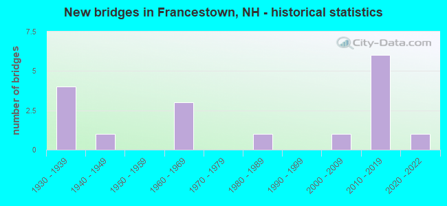
- New bridges - historical statistics
- 41930-1939
- 11940-1949
- 31960-1969
- 11980-1989
- 12000-2009
- 62010-2019
- 12020-2022
FCC Registered Cell Phone Towers:
1- Crotched Mountain Cell Site 3 Miles Wnw Of (Lat: 42.997583 Lon: -71.872583), Structure height: 33.5 m, Call Sign: KNKA483
Assigned Frequencies: 869.040 MHz, 869.040 MHz, 869.040 MHz, 890.010 MHz, 890.010 MHz, 890.010 MHz, 824.040 MHz, 824.040 MHz, 824.040 MHz, 845.010 MHz, 845.010 MHz, 845.010 MHzGrant Date: 01/23/2018, Expiration Date: 01/22/2028, Certifier: Steven T CampbellRegistrant: Wilkinson Barker Knauer, LLP, 1800 M Street Nw, Suite 800n, Washington, DC 20036, Phone: (202) 383-3420, Fax: (202) 783-5851, Email:
FCC Registered Antenna Towers:
6- PETER M CONNOLLY, 3 Miles Wnw (Lat: 42.997500 Lon: -71.872500), Type: 33.5, Overall height: 30.5 m, Registrant: Manchester-Nashua Cellular Telephone, L.P., Stephanie.Terrell@uscellular.Com, , Chica-go, Phone: (773) 399-8900
- PETER M CONNOLLY, 3 Miles Wnw (Lat: 42.997500 Lon: -71.872500), Type: 33.5, Overall height: 30.5 m, Registrant: Holland & Knight LLP, Pconnoll@hklaw.Com, , Washi-ngton, Phone: (202) 862-5989
- STEVEN T CAMPBELL, 3 Miles Wnw (Lat: 42.997500 Lon: -71.872500), Type: 33.5, Structure height: 33011 m, Overall height: 30.5 m, Registrant: Holland & Knight LLP, Peter.Connolly@hklaw.Com, , Washi-ngton, Phone: (202) 862-5989
- Cayla Gamble, 3 Miles Wnw (Lat: 42.997500 Lon: -71.872500), Type: 33.5, Structure height: 33011 m, Overall height: 30.5 m, Registrant: Wilkinson Barker Knauer, LLP, Gwerner@wbklaw.Com, , Washi-ngton, Phone: (202) 383-3420
- 3 Mi Wnw (Lat: 42.997500 Lon: -71.872500), Type: 33.5, Overall height: 30.5 m, Registrant: United States Cellular Corporation, Linda.Hartman@koteen.Com, , Washi-ngton, Phone: (202) 467-5700
- 3 Miles Wnw (Lat: 42.997500 Lon: -71.872500), Type: 33.5, Overall height: 30.5 m, Registrant: United States Cellular Corporation, Linda.Hartman@koteen.Com, , Washi-ngton, Phone: (202) 467-5700
FCC Registered Private Land Mobile Towers:
4- On Crotched Mountain 5 Km Wnw (Lat: 42.998139 Lon: -71.874250), Type: Tower, Structure height: 12 m, Call Sign: WPDH547,
Assigned Frequencies: 929.287 MHz, Grant Date: 09/30/1998, Expiration Date: 09/30/2008, Cancellation Date: 08/10/2001, Registrant: Wilkinson, Barker, Knauer LLP, 2300 N Street N.W., Suite 700, Washington, DC 20037-1128, Phone: (202) 783-4141, Fax: (202) 783-5851, Email:
- Crotched Mountain (Lat: 42.998528 Lon: -71.873944), Type: Tower, Structure height: 13.1 m, Overall height: 14.4 m, Call Sign: WPDH775, Licensee ID: L01422065,
Assigned Frequencies: 929.962 MHz, Grant Date: 06/26/2000, Expiration Date: 06/26/2010, Cancellation Date: 08/14/2010, Certifier: Shawn E Endsley, Registrant: Usa Mobility Wireless, Inc., 3000 Technology Dr. #400, Plano, TX 75074, Phone: (972) 801-0000, Fax: (972) 801-1699, Email:
- Crotched Mountain (Lat: 42.998139 Lon: -71.874250), Type: Tower, Structure height: 13 m, Overall height: 15 m, Call Sign: WPFI644,
Assigned Frequencies: 929.562 MHz, 929.612 MHz, Grant Date: 01/03/2001, Expiration Date: 09/22/2020, Cancellation Date: 06/28/2001, Certifier: Donna Comer, Registrant: Paging Network Of America, Inc., 1500 International Pkwy, Suite 300, Richardson, TX 75081, Phone: (972) 801-0304, Fax: (972) 801-0330
- On Crotched Mountain 3 Mi Wnw (Lat: 42.998139 Lon: -71.874250), Type: Tower, Structure height: 12 m, Overall height: 15 m, Call Sign: WPJS692,
Assigned Frequencies: 929.012 MHz, Grant Date: 10/09/1996, Expiration Date: 10/09/2006, Cancellation Date: 10/08/2002, Certifier: Paul H Kuzia, Registrant: Wilkinson Barker Knauer, LLP, 2300 N Street, N.W., 7th Floor, Washington, DC 20037, Phone: (202) 783-4141, Fax: (202) 783-5851, Email:
FCC Registered Broadcast Land Mobile Towers:
3- Fire Station (Lat: 42.982861 Lon: -71.805639), Call Sign: KCO366,
Assigned Frequencies: 153.770 MHz, 154.430 MHz, Grant Date: 11/06/2020, Expiration Date: 01/25/2031, Registrant: Swnh District Fire Mutual Aid, 32 Vernon St., Keene, NH 03431, Phone: (603) 352-8635, Fax: (603) 357-1985, Email:
- Crotched Mtn Ski Area Mountain Rd (Lat: 42.980639 Lon: -71.874528), Call Sign: KNEQ386,
Assigned Frequencies: 155.205 MHz, 155.220 MHz, 155.340 MHz, Grant Date: 12/29/2022, Expiration Date: 01/07/2033, Registrant: National Ski Patrol System Inc, 133 S Van Gordon St, Lakewood, CO 80228, Phone: (303) 988-1111, Email:
- Crotched Mtn Ski Area Off Mtn Rd (Lat: 42.998139 Lon: -71.875639), Type: Tower, Structure height: 12 m, Overall height: 17 m, Call Sign: KZI663,
Assigned Frequencies: 151.490 MHz, Grant Date: 03/06/1998, Expiration Date: 03/06/2003, Cancellation Date: 06/08/2003, Certifier: James Rymes, Registrant: Rymes Heating Oils Inc, Rr 2 Box 454, Antrim, NH 03440, Phone: (603) 588-6868, Fax: (603) 588-6868
FCC Registered Microwave Towers:
3 (See the full list of FCC Registered Microwave Towers in this town)FCC Registered Paging Towers:
5 (See the full list of FCC Registered Paging Towers)FCC Registered Amateur Radio Licenses:
22 (See the full list of FCC Registered Amateur Radio Licenses in Francestown)FAA Registered Aircraft:
2- Aircraft: PIPER PA-28-140 (Category: Land, Seats: 4, Weight: Up to 12,499 Pounds, Speed: 107 mph), Engine: LYCOMING 0-320 SERIES (180 HP) (Reciprocating)
N-Number: 5764U, N5764U, N-5764U, Serial Number: 28-26588, Year manufactured: 1970, Airworthiness Date: 02/23/1970, Certificate Issue Date: 05/22/2018
Registrant (Individual): Scott D Trustee Slingsby, 207 Wilson Hill Rd, Francestown, NH 03043 - Aircraft: CESSNA 150M (Category: Land, Seats: 2, Weight: Up to 12,499 Pounds, Speed: 81 mph), Engine: CONT MOTOR 0-200 SERIES (100 HP) (4 Cycle)
N-Number: 6343K, N6343K, N-6343K, Serial Number: 15077655, Year manufactured: 1975, Airworthiness Date: 12/03/1975, Certificate Issue Date: 02/27/2019
Registrant (Individual): Kevin D Magoon, 345 2nd Nh Tpke N, Francestown, NH 03043
2004 - 2018 National Fire Incident Reporting System (NFIRS) incidents
- Fire incident types reported to NFIRS in Francestown, NH
- 7459.2%Structure Fires
- 3225.6%Outside Fires
- 108.0%Mobile Property/Vehicle Fires
- 97.2%Other
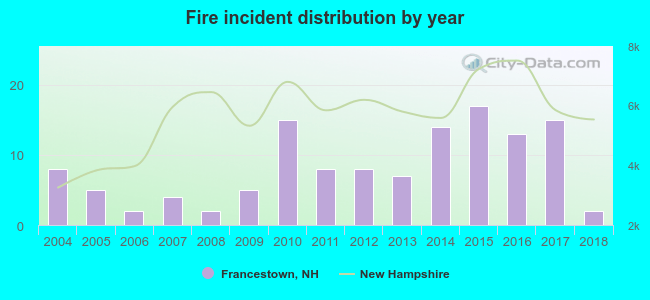 Based on the data from the years 2004 - 2018 the average number of fire incidents per year is 8. The highest number of reported fire incidents - 17 took place in 2015, and the least - 2 in 2006. The data has a dropping trend.
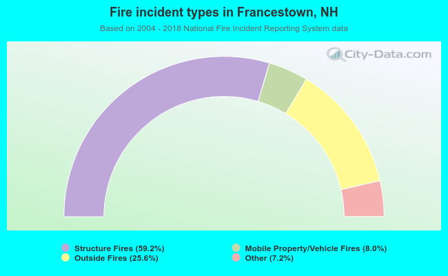 When looking into fire subcategories, the most incidents belonged to: Structure Fires (59.2%), and Outside Fires (25.6%).
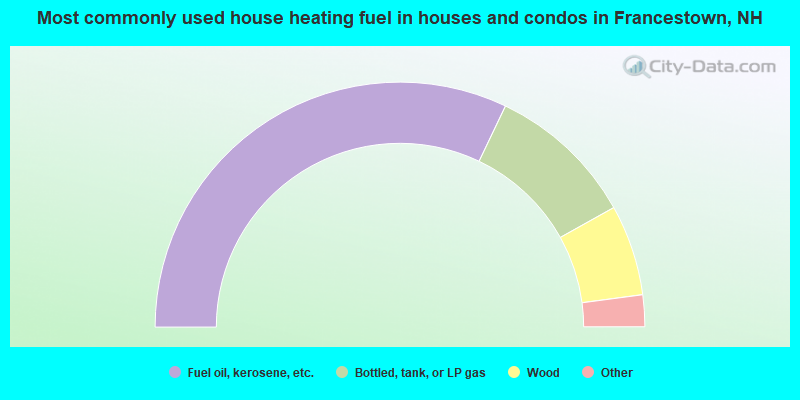
- 64.2%Fuel oil, kerosene, etc.
- 19.6%Bottled, tank, or LP gas
- 12.0%Wood
- 3.2%Electricity
- 0.6%Utility gas
- 0.4%Solar energy
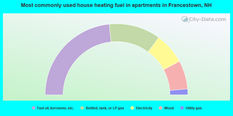
- 46.8%Fuel oil, kerosene, etc.
- 23.4%Bottled, tank, or LP gas
- 14.3%Electricity
- 13.0%Wood
- 2.6%Utility gas
Francestown compared to New Hampshire state average:
- Unemployed percentage significantly below state average.
- Black race population percentage significantly below state average.
- Hispanic race population percentage significantly below state average.
- Foreign-born population percentage significantly below state average.
- Renting percentage significantly below state average.
- Length of stay since moving in significantly above state average.
- Number of rooms per house significantly below state average.
- House age significantly below state average.

|
|
Total of 60 patent applications in 2008-2024.