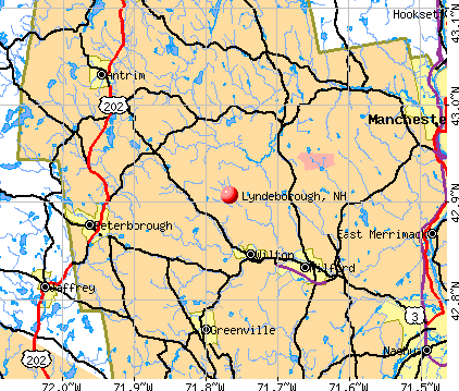
Lyndeborough, New Hampshire

Submit your own pictures of this town and show them to the world
- OSM Map
- General Map
- Google Map
- MSN Map
Population change since 2000: +6.2%
 |
| Males: 863 | |
| Females: 820 |
| Median resident age: | 44.9 years |
| New Hampshire median age: | 43.9 years |
Zip codes: 03082.
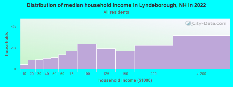
| Lyndeborough: | $108,366 |
| NH: | $89,992 |
Estimated per capita income in 2022: $54,183 (it was $27,169 in 2000)
Lyndeborough town income, earnings, and wages data
Estimated median house or condo value in 2022: $420,732 (it was $139,900 in 2000)
| Lyndeborough: | $420,732 |
| NH: | $384,700 |
Mean prices in 2022: all housing units: $411,252; detached houses: $441,251; townhouses or other attached units: $283,002; in 2-unit structures: $347,377; in 3-to-4-unit structures: $666,663; in 5-or-more-unit structures: $275,798; mobile homes: $132,093
Detailed information about poverty and poor residents in Lyndeborough, NH


- 1,58193.9%White alone
- 382.3%Two or more races
- 271.6%Hispanic
- 140.8%Black alone
- 140.8%Asian alone
- 60.4%Other race alone
- 30.2%American Indian alone
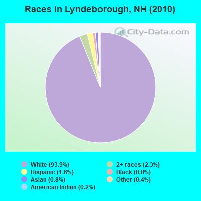
Races in Lyndeborough detailed stats: ancestries, foreign born residents, place of birth
According to our research of New Hampshire and other state lists, there was 1 registered sex offender living in Lyndeborough, New Hampshire as of June 07, 2024.
The ratio of all residents to sex offenders in Lyndeborough is 1,683 to 1.
The ratio of registered sex offenders to all residents in this city is much lower than the state average.
Type |
2013 |
2014 |
2015 |
2016 |
2017 |
2018 |
2019 |
2020 |
2021 |
2022 |
|---|---|---|---|---|---|---|---|---|---|---|
| Murders (per 100,000) | 0 (0.0) | 0 (0.0) | 0 (0.0) | 0 (0.0) | 0 (0.0) | 0 (0.0) | 0 (0.0) | 0 (0.0) | 0 (0.0) | 0 (0.0) |
| Rapes (per 100,000) | 0 (0.0) | 0 (0.0) | 0 (0.0) | 1 (58.6) | 1 (58.6) | 0 (0.0) | 0 (0.0) | 0 (0.0) | 0 (0.0) | 0 (0.0) |
| Robberies (per 100,000) | 0 (0.0) | 0 (0.0) | 0 (0.0) | 0 (0.0) | 0 (0.0) | 0 (0.0) | 0 (0.0) | 0 (0.0) | 0 (0.0) | 0 (0.0) |
| Assaults (per 100,000) | 0 (0.0) | 2 (118.2) | 0 (0.0) | 1 (58.6) | 1 (58.6) | 0 (0.0) | 0 (0.0) | 0 (0.0) | 0 (0.0) | 0 (0.0) |
| Burglaries (per 100,000) | 4 (237.8) | 4 (236.4) | 5 (294.8) | 5 (293.1) | 1 (58.6) | 0 (0.0) | 1 (57.5) | 0 (0.0) | 0 (0.0) | 0 (0.0) |
| Thefts (per 100,000) | 14 (832.3) | 11 (650.1) | 7 (412.7) | 8 (468.9) | 9 (527.2) | 7 (407.0) | 3 (172.4) | 5 (287.7) | 2 (115.3) | 2 (117.3) |
| Auto thefts (per 100,000) | 1 (59.5) | 1 (59.1) | 1 (59.0) | 1 (58.6) | 1 (58.6) | 1 (58.1) | 1 (57.5) | 0 (0.0) | 0 (0.0) | 0 (0.0) |
| Arson (per 100,000) | 1 (59.5) | 0 (0.0) | 0 (0.0) | 0 (0.0) | 0 (0.0) | 0 (0.0) | 0 (0.0) | 0 (0.0) | 0 (0.0) | 0 (0.0) |
| City-Data.com crime index | 54.7 | 70.9 | 41.9 | 102.6 | 88.5 | 20.9 | 15.5 | 11.5 | 4.6 | 4.7 |
The City-Data.com crime index weighs serious crimes and violent crimes more heavily. Higher means more crime, U.S. average is 246.1. It adjusts for the number of visitors and daily workers commuting into cities.
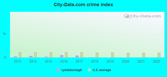
Crime rate in Lyndeborough detailed stats: murders, rapes, robberies, assaults, burglaries, thefts, arson
Full-time law enforcement employees in 2019, including police officers: 1 (1 officers - 0 male; 1 female).
| Officers per 1,000 residents here: | 0.57 |
| New Hampshire average: | 2.20 |
 Recent articles from our blog. Our writers, many of them Ph.D. graduates or candidates, create easy-to-read articles on a wide variety of topics.

 | Moving to Peterborough..from Kauai (42 replies) |
| High Speed Internet, like Fios (18 replies) |
| Looking at Southern NH...Where would you recommend searching? (15 replies) |
| Has Anyone Moved to New Hampshire and Regretted It? (337 replies) |
| talk to me about the new boston area (19 replies) |
| Moving to Southern NH/ Pipeline concerns (26 replies) |
Latest news from Lyndeborough, NH collected exclusively by city-data.com from local newspapers, TV, and radio stations
Ancestries: English (21.1%), Irish (14.2%), French (11.2%), German (9.3%), United States (8.8%), Scottish (7.2%).
Current Local Time: EST time zone
Elevation: 892 feet
Land area: 31.1 square miles.
Population density: 54 people per square mile (very low).
57 residents are foreign born (2.4% Europe, 0.8% North America).
| This town: | 3.6% |
| New Hampshire: | 4.4% |
| Lyndeborough town: | 2.0% ($2,824) |
| New Hampshire: | 2.3% ($2,946) |
Nearest city with pop. 50,000+: Manchester, NH  (17.4 miles , pop. 107,006).
Nearest city with pop. 200,000+: Boston, MA (52.9 miles , pop. 589,141).
Nearest city with pop. 1,000,000+: Bronx, NY (178.4 miles , pop. 1,332,650).
Nearest cities:
), ), ), ), ), Latitude: 42.90 N, Longitude: 71.77 W
Area code commonly used in this area: 603

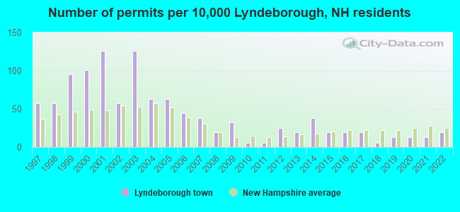
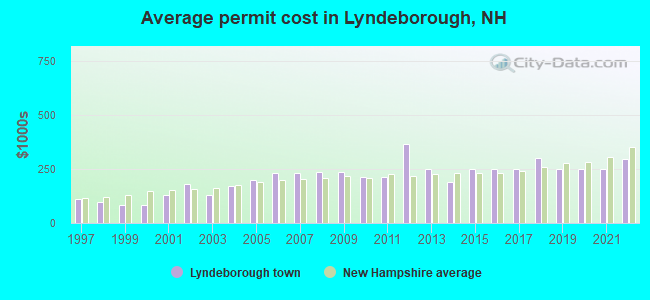
Single-family new house construction building permits:
- 2022: 3 buildings, average cost: $298,700
- 2021: 2 buildings, average cost: $250,000
- 2020: 2 buildings, average cost: $250,000
- 2019: 2 buildings, average cost: $250,000
- 2018: 1 building, cost: $300,000
- 2017: 3 buildings, average cost: $250,000
- 2016: 3 buildings, average cost: $250,000
- 2015: 3 buildings, average cost: $250,000
- 2014: 6 buildings, average cost: $190,500
- 2013: 3 buildings, average cost: $250,000
- 2012: 4 buildings, average cost: $365,000
- 2011: 1 building, cost: $211,900
- 2010: 1 building, cost: $211,900
- 2009: 5 buildings, average cost: $237,500
- 2008: 3 buildings, average cost: $237,500
- 2007: 6 buildings, average cost: $231,400
- 2006: 7 buildings, average cost: $231,400
- 2005: 10 buildings, average cost: $200,000
- 2004: 10 buildings, average cost: $171,800
- 2003: 20 buildings, average cost: $131,300
- 2002: 9 buildings, average cost: $179,400
- 2001: 20 buildings, average cost: $129,900
- 2000: 16 buildings, average cost: $82,100
- 1999: 15 buildings, average cost: $82,100
- 1998: 9 buildings, average cost: $96,600
- 1997: 9 buildings, average cost: $110,200
| Here: | 3.0% |
| New Hampshire: | 2.5% |
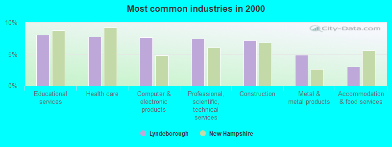
- Educational services (8.1%)
- Health care (7.8%)
- Computer & electronic products (7.6%)
- Professional, scientific, technical services (7.4%)
- Construction (7.2%)
- Metal & metal products (4.9%)
- Accommodation & food services (3.0%)
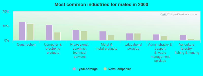
- Construction (12.8%)
- Computer & electronic products (11.0%)
- Professional, scientific, technical services (7.3%)
- Metal & metal products (6.3%)
- Educational services (4.9%)
- Administrative & support & waste management services (4.3%)
- Agriculture, forestry, fishing & hunting (3.7%)
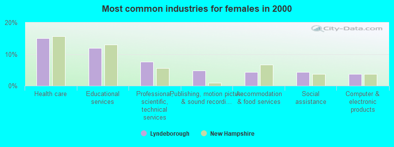
- Health care (15.1%)
- Educational services (11.9%)
- Professional, scientific, technical services (7.5%)
- Publishing, motion picture & sound recording industries (4.9%)
- Accommodation & food services (4.4%)
- Social assistance (4.4%)
- Computer & electronic products (3.6%)
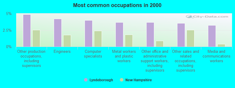
- Other production occupations, including supervisors (4.9%)
- Engineers (4.2%)
- Computer specialists (4.0%)
- Metal workers and plastic workers (3.7%)
- Other office and administrative support workers, including supervisors (3.7%)
- Other sales and related occupations, including supervisors (3.5%)
- Media and communications workers (3.2%)
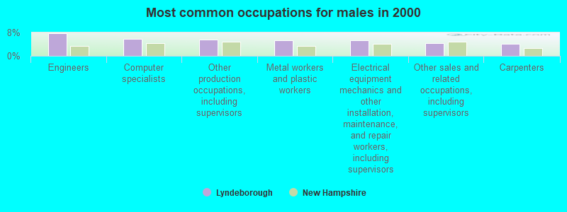
- Engineers (7.7%)
- Computer specialists (5.9%)
- Other production occupations, including supervisors (5.5%)
- Metal workers and plastic workers (5.3%)
- Electrical equipment mechanics and other installation, maintenance, and repair workers, including supervisors (5.3%)
- Other sales and related occupations, including supervisors (4.5%)
- Carpenters (4.1%)

- Preschool, kindergarten, elementary, and middle school teachers (5.6%)
- Media and communications workers (4.9%)
- Registered nurses (4.9%)
- Information and record clerks, except customer service representatives (4.4%)
- Bookkeeping, accounting, and auditing clerks (4.1%)
- Child care workers (4.1%)
- Other production occupations, including supervisors (4.1%)
Average climate in Lyndeborough, New Hampshire
Based on data reported by over 4,000 weather stations


(lower is better)
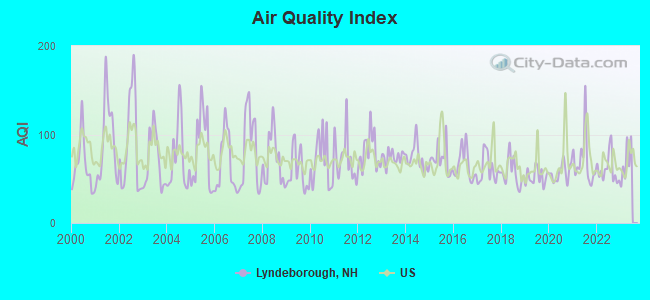
Air Quality Index (AQI) level in 2022 was 60.7. This is about average.
| City: | 60.7 |
| U.S.: | 72.6 |
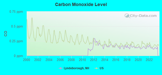
Carbon Monoxide (CO) [ppm] level in 2022 was 0.134. This is significantly better than average. Closest monitor was 5.9 miles away from the city center.
| City: | 0.134 |
| U.S.: | 0.251 |

Nitrogen Dioxide (NO2) [ppb] level in 2022 was 2.05. This is significantly better than average. Closest monitor was 5.9 miles away from the city center.
| City: | 2.05 |
| U.S.: | 5.11 |
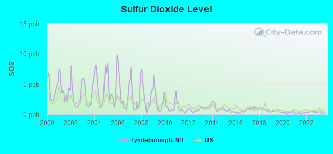
Sulfur Dioxide (SO2) [ppb] level in 2022 was 0.384. This is significantly better than average. Closest monitor was 5.9 miles away from the city center.
| City: | 0.384 |
| U.S.: | 1.515 |
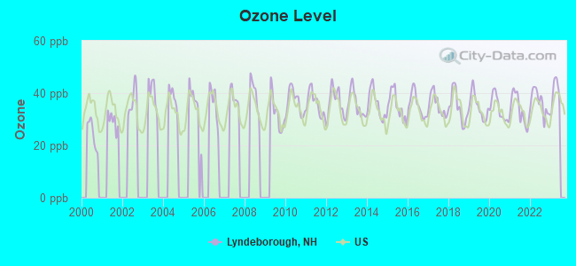
Ozone [ppb] level in 2022 was 36.4. This is about average. Closest monitor was 5.9 miles away from the city center.
| City: | 36.4 |
| U.S.: | 33.3 |
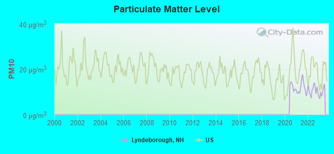
Particulate Matter (PM10) [µg/m3] level in 2022 was 10.6. This is significantly better than average. Closest monitor was 5.9 miles away from the city center.
| City: | 10.6 |
| U.S.: | 19.2 |
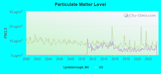
Particulate Matter (PM2.5) [µg/m3] level in 2022 was 4.31. This is significantly better than average. Closest monitor was 5.9 miles away from the city center.
| City: | 4.31 |
| U.S.: | 8.11 |
Tornado activity:
Lyndeborough-area historical tornado activity is above New Hampshire state average. It is 29% smaller than the overall U.S. average.
On 6/9/1953, a category F4 (max. wind speeds 207-260 mph) tornado 35.8 miles away from the Lyndeborough town center killed 90 people and injured 1228 people and caused between $50,000,000 and $500,000,000 in damages.
On 6/22/1981, a category F3 (max. wind speeds 158-206 mph) tornado 24.9 miles away from the town center injured 3 people and caused between $5000 and $50,000 in damages.
Earthquake activity:
Lyndeborough-area historical earthquake activity is significantly above New Hampshire state average. It is 71% smaller than the overall U.S. average.On 4/20/2002 at 10:50:47, a magnitude 5.3 (5.3 ML, Depth: 3.0 mi, Class: Moderate, Intensity: VI - VII) earthquake occurred 147.4 miles away from Lyndeborough center
On 10/7/1983 at 10:18:46, a magnitude 5.3 (5.1 MB, 5.3 LG, 5.1 ML) earthquake occurred 148.3 miles away from Lyndeborough center
On 4/20/2002 at 10:50:47, a magnitude 5.2 (5.2 MB, 4.2 MS, 5.2 MW, 5.0 MW) earthquake occurred 146.8 miles away from the city center
On 1/19/1982 at 00:14:42, a magnitude 4.7 (4.5 MB, 4.7 MD, 4.5 LG, Class: Light, Intensity: IV - V) earthquake occurred 42.6 miles away from Lyndeborough center
On 10/16/2012 at 23:12:25, a magnitude 4.7 (4.7 ML, Depth: 10.0 mi) earthquake occurred 74.2 miles away from the city center
On 10/2/1994 at 11:27:22, a magnitude 3.7 (3.5 LG, 3.7 LG, Depth: 6.2 mi, Class: Light, Intensity: II - III) earthquake occurred 45.9 miles away from the city center
Magnitude types: regional Lg-wave magnitude (LG), body-wave magnitude (MB), duration magnitude (MD), local magnitude (ML), surface-wave magnitude (MS), moment magnitude (MW)
Natural disasters:
The number of natural disasters in Hillsborough County (27) is a lot greater than the US average (15).Major Disasters (Presidential) Declared: 17
Emergencies Declared: 10
Causes of natural disasters: Storms: 13, Floods: 11, Winter Storms: 5, Snowstorms: 4, Hurricanes: 3, Snows: 3, Blizzard: 1, Ice Storm: 1, Snowfall: 1, Wind: 1 (Note: some incidents may be assigned to more than one category).
Hospitals and medical centers near Lyndeborough:
- ST JOSEPH HOME AND HOSPICE CARE (Home Health Center, about 7 miles away; MILFORD, NH)
- CRESTWOOD CARE AND REHABILITATION CENTER (Nursing Home, about 8 miles away; MILFORD, NH)
- ELM'S NURSING AND REHAB CENTER (THE) (Nursing Home, about 8 miles away; MILFORD, NH)
- MONADNOCK COMMUNITY HOSPITAL Critical Access Hospitals (about 9 miles away; PETERBOROUGH, NH)
- PHEASANT WOOD CARE AND REHABILIATION CENTER (Nursing Home, about 9 miles away; PETERBOROUGH, NH)
- GOOD SHEPHERD REHABILITATION AND NURSING CENTER (Nursing Home, about 14 miles away; JAFFREY, NH)
- BEL AIR NURSING HOME (Nursing Home, about 15 miles away; GOFFSTOWN, NH)
Colleges/universities with over 2000 students nearest to Lyndeborough:
- Saint Anselm College (about 15 miles; Manchester, NH; Full-time enrollment: 2,059)
- Mount Washington College (about 17 miles; Manchester, NH; FT enrollment: 2,187)
- Franklin Pierce University (about 17 miles; Rindge, NH; FT enrollment: 2,139)
- Southern New Hampshire University (about 19 miles; Manchester, NH; FT enrollment: 16,552)
- Fitchburg State University (about 22 miles; Fitchburg, MA; FT enrollment: 5,010)
- Mount Wachusett Community College (about 24 miles; Gardner, MA; FT enrollment: 3,143)
- NHTI-Concord's Community College (about 26 miles; Concord, NH; FT enrollment: 2,865)
Public elementary/middle school in Lyndeborough:
- LYNDEBOROUGH CENTRAL SCHOOL (Students: 83, Location: 192 FOREST RD., Grades: KG-5)
Points of interest:
Notable location: Lyndeborough Fire Department (A). Display/hide its location on the map
Cemeteries: North Lyndeborough Cemetery (1), South Lyndeborough Cemetery (2). Display/hide their locations on the map
Lakes and reservoirs: Badger Pond (A), Burton Pond (B), Swartz Pond (C). Display/hide their locations on the map
Parks in Lyndeborough include: Lyndeborough Center Historic District (1), Curtiss Dogwood State Park (2). Display/hide their locations on the map
Drinking water stations with addresses in Lyndeborough and their reported violations in the past:
VILLAGE STORE (Population served: 50, Groundwater):Past health violations:
- MCL, Acute (TCR) - Between OCT-2012 and DEC-2012, Contaminant: Coliform. Follow-up actions: St Public Notif requested (DEC-24-2012), St Violation/Reminder Notice (DEC-24-2012), St Public Notif received (DEC-31-2012), St Compliance achieved (JUL-17-2013)
| This town: | 2.6 people |
| New Hampshire: | 2.5 people |
| This town: | 76.7% |
| Whole state: | 66.3% |
| This town: | 7.5% |
| Whole state: | 8.3% |
Likely homosexual households (counted as self-reported same-sex unmarried-partner households)
- Lesbian couples: 0.6% of all households
- Gay men: 0.8% of all households
| This town: | 3.3% |
| Whole state: | 6.5% |
| This town: | 1.4% |
| Whole state: | 2.8% |
For population 15 years and over in Lyndeborough:
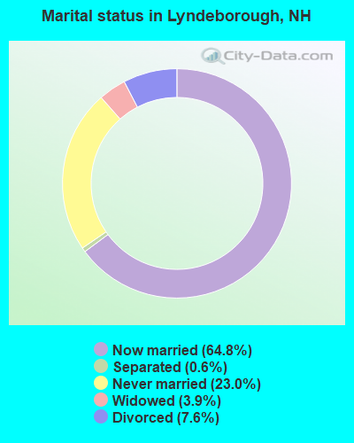
- Never married: 23.0%
- Now married: 64.8%
- Separated: 0.6%
- Widowed: 3.9%
- Divorced: 7.6%
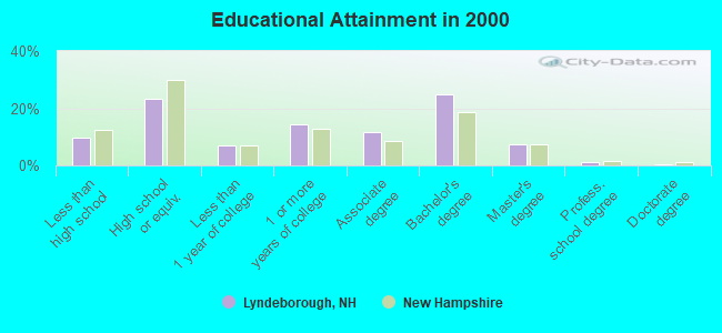
For population 25 years and over in Lyndeborough:
- High school or higher: 90.5%
- Bachelor's degree or higher: 34.1%
- Graduate or professional degree: 9.2%
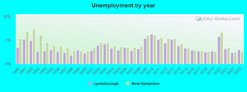
- Unemployed: 2.8%
- Mean travel time to work (commute): 35.4 minutes
| Here: | 9.3 |
| New Hampshire average: | 10.9 |


Graphs represent county-level data. Detailed 2008 Election Results
Religion statistics for Lyndeborough, NH (based on Hillsborough County data)


| Religion | Adherents | Congregations |
|---|---|---|
| Catholic | 124,993 | 40 |
| Evangelical Protestant | 20,588 | 103 |
| Mainline Protestant | 17,794 | 60 |
| Other | 7,365 | 35 |
| Orthodox | 2,990 | 7 |
| Black Protestant | - | 1 |
| None | 226,991 | - |
Food Environment Statistics:
| This county: | 1.82 / 10,000 pop. |
| State: | 2.14 / 10,000 pop. |
| Hillsborough County: | 0.12 / 10,000 pop. |
| State: | 0.15 / 10,000 pop. |
| This county: | 1.65 / 10,000 pop. |
| New Hampshire: | 1.78 / 10,000 pop. |
| Hillsborough County: | 2.67 / 10,000 pop. |
| State: | 4.02 / 10,000 pop. |
| This county: | 8.23 / 10,000 pop. |
| State: | 9.70 / 10,000 pop. |
| Hillsborough County: | 6.9% |
| New Hampshire: | 7.6% |
| Hillsborough County: | 24.5% |
| State: | 24.4% |
| Hillsborough County: | 15.1% |
| New Hampshire: | 15.9% |
6.73% of this county's 2021 resident taxpayers lived in other counties in 2020 ($92,767 average adjusted gross income)
| Here: | 6.73% |
| New Hampshire average: | 7.66% |
0.01% of residents moved from foreign countries ($183 average AGI)
Hillsborough County: 0.01% New Hampshire average: 0.01%
Top counties from which taxpayers relocated into this county between 2020 and 2021:
| from Middlesex County, MA | |
| from Rockingham County, NH | |
| from Merrimack County, NH |
6.49% of this county's 2020 resident taxpayers moved to other counties in 2021 ($81,100 average adjusted gross income)
| Here: | 6.49% |
| New Hampshire average: | 6.80% |
0.02% of residents moved to foreign countries ($105 average AGI)
Hillsborough County: 0.02% New Hampshire average: 0.01%
Top counties to which taxpayers relocated from this county between 2020 and 2021:
| to Rockingham County, NH | |
| to Merrimack County, NH | |
| to Middlesex County, MA |
Strongest AM radio stations in Lyndeborough:
- WRKO (680 AM; 50 kW; BOSTON, MA; Owner: ENTERCOM BOSTON LICENSE, LLC)
- WCRN (830 AM; 50 kW; WORCESTER, MA; Owner: CARTER BROADCASTING CORPORATION)
- WGIR (610 AM; 5 kW; MANCHESTER, NH; Owner: CAPSTAR TX LIMITED PARTNERSHIP)
- WEEI (850 AM; 50 kW; BOSTON, MA; Owner: ENTERCOM BOSTON LICENSE, LLC)
- WKOX (1200 AM; 50 kW; FRAMINGHAM, MA; Owner: CAPSTAR TX LIMITED PARTNERSHIP)
- WBIX (1060 AM; 40 kW; NATICK, MA; Owner: LANGER BROADCASTING CORPORATION)
- WKBR (1250 AM; 5 kW; MANCHESTER, NH; Owner: DEVON BROADCASTING COMPANY, INC.)
- WWZN (1510 AM; 50 kW; BOSTON, MA; Owner: ROSE CITY RADIO CORPORATION)
- WFEA (1370 AM; 5 kW; MANCHESTER, NH; Owner: SAGA COMMUNICATIONS OF NEW ENGLAND, LLC)
- WNNZ (640 AM; 50 kW; WESTFIELD, MA; Owner: CLEAR CHANNEL BROADCASTING LICENSES, INC.)
- WVNE (760 AM; daytime; 25 kW; LEICESTER, MA; Owner: BLOUNT MASSCOM, INC.)
- WDER (1320 AM; 10 kW; DERRY, NH; Owner: BLOUNT COMMUNICATIONS, INC. OF NH)
- WBZ (1030 AM; 50 kW; BOSTON, MA; Owner: INFINITY BROADCASTING OPERATIONS, INC.)
Strongest FM radio stations in Lyndeborough:
- WFEX (92.1 FM; PETERBOROUGH, NH; Owner: FNX BROADCASTING OF NEW HAMPSHIRE LLC)
- WGIR-FM (101.1 FM; MANCHESTER, NH; Owner: CAPSTAR TX LIMITED PARTNERSHIP)
- WQLL (96.5 FM; BEDFORD, NH; Owner: SAGA COMMUNICATIONS OF NEW ENGLAND, LLC)
- WLMW (90.7 FM; MANCHESTER, NH; Owner: KNOWLEDGE FOR LIFE)
- WZID (95.7 FM; MANCHESTER, NH; Owner: SAGA COMMUNICATIONS OF NEW ENGLAND, LLC)
- WTPL (107.7 FM; HILLSBORO, NH; Owner: CONCORD BROADCASTING, L.L.C.)
- WHDQ (106.1 FM; CLAREMONT, NH; Owner: GREAT NORTHERN RADIO, L.L.C.)
- WNNH (99.1 FM; HENNIKER, NH; Owner: TELE-MEDIA COMPANY OF NEW HAMPSHIRE, L.L.C.)
- WVPR (89.5 FM; WINDSOR, VT; Owner: VERMONT PUBLIC RADIO)
- WKNE (103.7 FM; KEENE, NH; Owner: SAGA COMMUNICATIONS OF NEW ENGLAND, LLC)
- WEVN (90.7 FM; KEENE, NH; Owner: NEW HAMPSHIRE PUBLIC RADIO, INC.)
- WJJR (98.1 FM; RUTLAND, VT; Owner: 6 JOHNSON ROAD LICENSES, INC.)
- WZRT (97.1 FM; RUTLAND, VT; Owner: CAPSTAR TX LIMITED PARTNERSHIP)
- WHOB (106.3 FM; NASHUA, NH; Owner: TELE-MEDIA COMPANY OF NEW HAMPSHIRE, L.L.C.)
- WINQ (97.7 FM; WINCHENDON, MA; Owner: SAGA COMMUNICATIONS OF NEW ENGLAND, LLC)
- WEQX (102.7 FM; MANCHESTER, VT; Owner: NORTHSHIRE COMMUNICATIONS, INC.)
- WNHI (93.3 FM; BELMONT, NH; Owner: CONCORD BROADCASTING, L.L.C.)
- WXLO (104.5 FM; FITCHBURG, MA; Owner: CITADEL BROADCASTING COMPANY)
- WSCY (106.9 FM; MOULTONBOROUGH, NH; Owner: NORTHEAST COMMUNICATIONS CORPORATION)
- WAAF (107.3 FM; WORCESTER, MA; Owner: ENTERCOM BOSTON LICENSE, LLC)
TV broadcast stations around Lyndeborough:
- WMUR-TV (Channel 9; MANCHESTER, NH; Owner: HEARST-ARGYLE PROPERTIES, INC.)
- WUNI (Channel 27; WORCESTER, MA; Owner: ENTRAVISION HOLDINGS, LLC)
- WUTF (Channel 66; MARLBOROUGH, MA; Owner: TELEFUTURA BOSTON LLC)
- WCVB-TV (Channel 5; BOSTON, MA; Owner: WCVB HEARST-ARGYLE TV, INC.)
- WGBH-TV (Channel 2; BOSTON, MA; Owner: WGBH EDUCATIONAL FOUNDATION)
- WFXZ-CA (Channel 24; BOSTON, MA; Owner: BOSTON BROADCASTING CORP.)
- WNDS (Channel 50; DERRY, NH; Owner: CTV OF DERRY, INC)
- WMFP (Channel 62; LAWRENCE, MA; Owner: WSAH LICENSE, INC.)
- WBZ-TV (Channel 4; BOSTON, MA; Owner: VIACOM INC.)
- WGBX-TV (Channel 44; BOSTON, MA; Owner: WGBH EDUCATIONAL FOUNDATION)
- WSBK-TV (Channel 38; BOSTON, MA; Owner: VIACOM INC.)
- WLVI-TV (Channel 56; CAMBRIDGE, MA; Owner: WLVI, INC.)
- WNEU (Channel 60; MERRIMACK, NH; Owner: NBC SUBSIDIARY (NH), INC.)
Lyndeborough fatal accident list:
Sep 17, 2010 08:15 PM, Center Road, Perham Corner Road, Lat: 42.863414, Lon: -71.718406, Vehicles: 1, Persons: 1, Fatalities: 1, Drunk persons involved: 1
Jul 4, 2004 01:30 AM, Sr-31, Greenfield T/Line, Vehicles: 1, Persons: 1, Fatalities: 1, Drunk persons involved: 1
Jul 6, 2003 02:25 PM, Sr-31, Vehicles: 1, Persons: 1, Fatalities: 1
- National Bridge Inventory (NBI) Statistics
- 2Number of bridges
- 7ft / 2.3mTotal length
- $6,284,000Total costs
- 244Total average daily traffic
- 9Total average daily truck traffic
- 360Total future (year 2042) average daily traffic
FCC Registered Broadcast Land Mobile Towers:
1- Lyndeborough Center Rd (Lat: 42.866750 Lon: -71.724528), Call Sign: KRL822,
Assigned Frequencies: 152.900 MHz, Grant Date: 02/02/2000, Expiration Date: 03/01/2005, Cancellation Date: 05/07/2005, Registrant: Woodmont Orchards Inc, Rr 1 Box 356, Lyndeborough, NH 03082, Phone: (603) 432-3311
FCC Registered Amateur Radio Licenses:
46 (See the full list of FCC Registered Amateur Radio Licenses in Lyndeborough)FAA Registered Aircraft:
1- Aircraft: AERONCA 7AC-CONV (Category: Land, Seats: 2, Weight: Up to 12,499 Pounds), Engine: CONT MOTOR C85 SERIES (85 HP) (Reciprocating)
N-Number: 1274E, N1274E, N-1274E, Serial Number: 7AC-4832, Year manufactured: 1946, Airworthiness Date: 08/20/1957, Certificate Issue Date: 10/14/2004
Registrant (Individual): Kurt M Charpentier, 43 Pettingill Hill Rd, Lyndeborough, NH 03082
2005 - 2018 National Fire Incident Reporting System (NFIRS) incidents
- Fire incident types reported to NFIRS in Lyndeborough, NH
- 9159.9%Structure Fires
- 4529.6%Outside Fires
- 127.9%Other
- 42.6%Mobile Property/Vehicle Fires
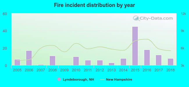 According to the data from the years 2005 - 2018 the average number of fire incidents per year is 11. The highest number of reported fires - 45 took place in 2015, and the least - 0 in 2009. The data has a growing trend.
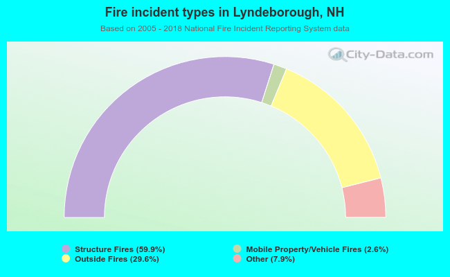 When looking into fire subcategories, the most reports belonged to: Structure Fires (59.9%), and Outside Fires (29.6%).
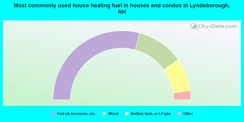
- 58.2%Fuel oil, kerosene, etc.
- 22.0%Wood
- 15.7%Bottled, tank, or LP gas
- 2.2%Electricity
- 1.4%Utility gas
- 0.4%Other fuel
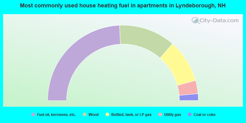
- 48.6%Fuel oil, kerosene, etc.
- 24.3%Wood
- 18.6%Bottled, tank, or LP gas
- 5.7%Utility gas
- 2.9%Coal or coke
Lyndeborough compared to New Hampshire state average:
- Unemployed percentage significantly below state average.
- Hispanic race population percentage below state average.
- Foreign-born population percentage below state average.
- Renting percentage significantly below state average.
- Length of stay since moving in significantly above state average.
- Number of rooms per house significantly below state average.
- House age significantly below state average.

|
|
Total of 71 patent applications in 2008-2024.