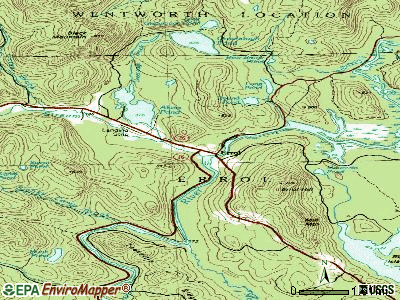
Errol, New Hampshire
Submit your own pictures of this town and show them to the world
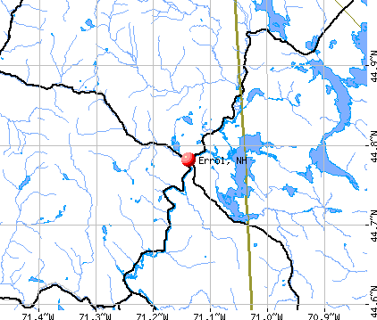
- OSM Map
- General Map
- Google Map
- MSN Map
Population change since 2000: -2.3%
 |
| Males: 154 | |
| Females: 137 |
| Median resident age: | 53.1 years |
| New Hampshire median age: | 43.9 years |
Zip codes: 03579.
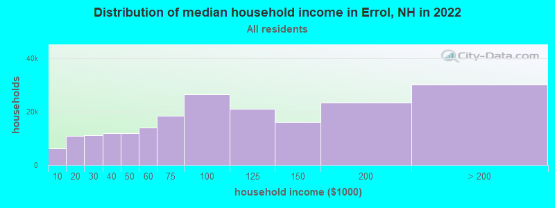
| Errol: | $58,039 |
| NH: | $89,992 |
Estimated per capita income in 2022: $43,355 (it was $22,440 in 2000)
Errol town income, earnings, and wages data
Estimated median house or condo value in 2022: $222,840 (it was $85,700 in 2000)
| Errol: | $222,840 |
| NH: | $384,700 |
Mean prices in 2022: all housing units: $223,643; detached houses: $241,655; townhouses or other attached units: $431,348; in 2-unit structures: $202,937; in 3-to-4-unit structures: $301,182; in 5-or-more-unit structures: $411,054; mobile homes: $86,091
Detailed information about poverty and poor residents in Errol, NH


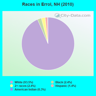
- 27293.5%White alone
- 72.4%Black alone
- 72.4%Two or more races
- 41.4%Hispanic
- 10.3%American Indian alone
Races in Errol detailed stats: ancestries, foreign born residents, place of birth
 Recent articles from our blog. Our writers, many of them Ph.D. graduates or candidates, create easy-to-read articles on a wide variety of topics.

 | Cougar/Mountain Lion sighted in Wakefield... off of Route 16 (47 replies) |
| Places to visit October (7 replies) |
| Which state could be considered as more mountainous, NH or Maine??? (10 replies) |
| Moving to Berlin, is it that scary? (100 replies) |
| State of public schools in New Hampshire (30 replies) |
| Pay attention North Hampton NH (77 replies) |
Latest news from Errol, NH collected exclusively by city-data.com from local newspapers, TV, and radio stations
Ancestries: French Canadian (26.5%), French (25.2%), English (17.8%), Italian (12.1%), United States (11.7%), Irish (9.1%).
Current Local Time: EST time zone
Incorporated in 1836
Elevation: 1228 feet
Land area: 61.0 square miles.
Population density: 4.8 people per square mile (very low).
17 residents are foreign born (3.7% North America, 1.3% Europe, 0.7% Asia).
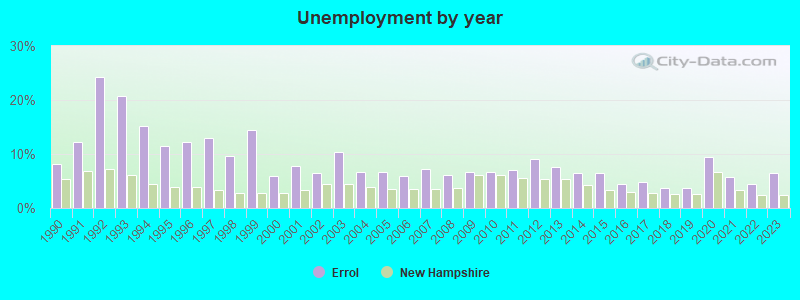
| This town: | 5.7% |
| New Hampshire: | 4.4% |
| Errol town: | 1.3% ($1,102) |
| New Hampshire: | 2.3% ($2,946) |
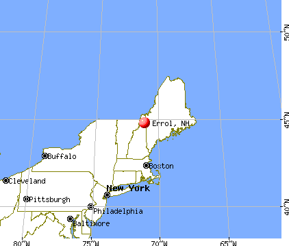
Nearest city with pop. 50,000+: Portland, ME  (88.2 miles , pop. 64,249).
Nearest city with pop. 200,000+: Boston, MA (169.9 miles , pop. 589,141).
Nearest city with pop. 1,000,000+: Bronx, NY (305.2 miles , pop. 1,332,650).
Nearest cities:
), ), ), ), )Latitude: 44.78 N, Longitude: 71.14 W
Area code: 603

| Here: | 6.4% |
| New Hampshire: | 2.5% |
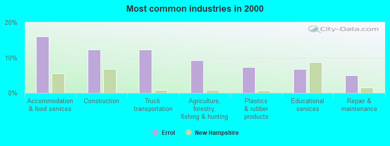
- Accommodation & food services (16.0%)
- Construction (12.3%)
- Truck transportation (12.3%)
- Agriculture, forestry, fishing & hunting (9.2%)
- Plastics & rubber products (7.4%)
- Educational services (6.7%)
- Repair & maintenance (4.9%)
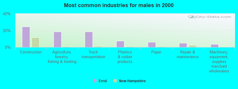
- Construction (24.4%)
- Agriculture, forestry, fishing & hunting (18.3%)
- Truck transportation (18.3%)
- Plastics & rubber products (7.3%)
- Paper (6.1%)
- Repair & maintenance (4.9%)
- Machinery, equipment, supplies merchant wholesalers (3.7%)
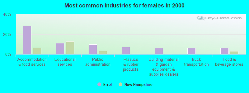
- Accommodation & food services (28.4%)
- Educational services (11.1%)
- Public administration (9.9%)
- Plastics & rubber products (7.4%)
- Building material & garden equipment & supplies dealers (6.2%)
- Truck transportation (6.2%)
- Food & beverage stores (6.2%)
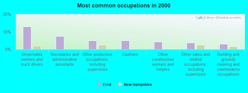
- Driver/sales workers and truck drivers (12.9%)
- Secretaries and administrative assistants (7.4%)
- Other production occupations, including supervisors (4.9%)
- Cashiers (4.9%)
- Other construction workers and helpers (4.3%)
- Other sales and related occupations, including supervisors (3.7%)
- Building and grounds cleaning and maintenance occupations (3.1%)
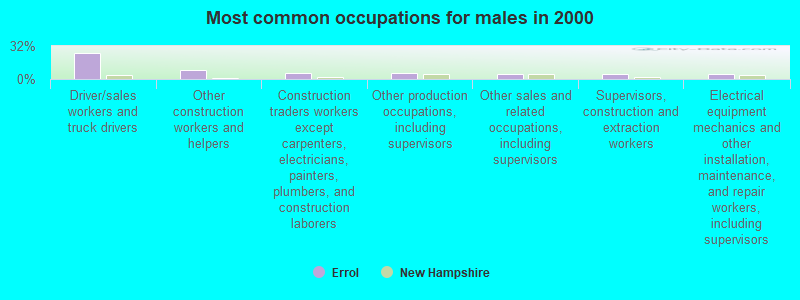
- Driver/sales workers and truck drivers (25.6%)
- Other construction workers and helpers (8.5%)
- Construction traders workers except carpenters, electricians, painters, plumbers, and construction laborers (6.1%)
- Other production occupations, including supervisors (6.1%)
- Other sales and related occupations, including supervisors (4.9%)
- Supervisors, construction and extraction workers (4.9%)
- Electrical equipment mechanics and other installation, maintenance, and repair workers, including supervisors (4.9%)

- Secretaries and administrative assistants (14.8%)
- Cashiers (9.9%)
- Bookkeeping, accounting, and auditing clerks (6.2%)
- Assemblers and fabricators (6.2%)
- Preschool, kindergarten, elementary, and middle school teachers (4.9%)
- Waiters and waitresses (4.9%)
- Other food preparation and serving workers, including supervisors (4.9%)
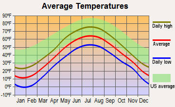
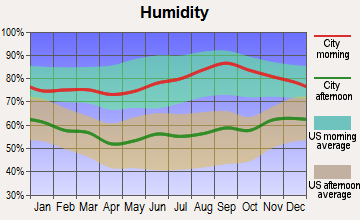
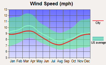
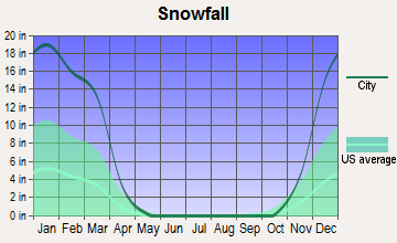
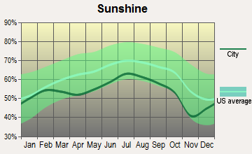
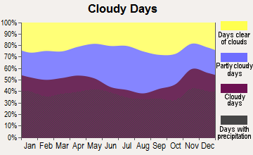
Average climate in Errol, New Hampshire
Based on data reported by over 4,000 weather stations
(lower is better)
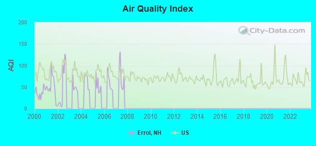
Air Quality Index (AQI) level in 2002 was 50.6. This is significantly better than average.
| City: | 50.6 |
| U.S.: | 72.6 |
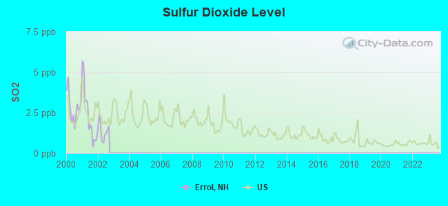
Sulfur Dioxide (SO2) [ppb] level in 2002 was 1.37. This is about average. Closest monitor was 20.1 miles away from the city center.
| City: | 1.37 |
| U.S.: | 1.51 |
Earthquake activity:
Errol-area historical earthquake activity is significantly above New Hampshire state average. It is 78% smaller than the overall U.S. average.On 4/20/2002 at 10:50:47, a magnitude 5.3 (5.3 ML, Depth: 3.0 mi, Class: Moderate, Intensity: VI - VII) earthquake occurred 127.2 miles away from the city center
On 4/20/2002 at 10:50:47, a magnitude 5.2 (5.2 MB, 4.2 MS, 5.2 MW, 5.0 MW) earthquake occurred 128.5 miles away from the city center
On 10/7/1983 at 10:18:46, a magnitude 5.3 (5.1 MB, 5.3 LG, 5.1 ML) earthquake occurred 168.3 miles away from the city center
On 10/16/2012 at 23:12:25, a magnitude 4.7 (4.7 ML, Depth: 10.0 mi, Class: Light, Intensity: IV - V) earthquake occurred 85.1 miles away from Errol center
On 1/19/1982 at 00:14:42, a magnitude 4.7 (4.5 MB, 4.7 MD, 4.5 LG) earthquake occurred 91.3 miles away from the city center
On 8/21/1996 at 07:54:14, a magnitude 3.8 (3.8 LG, 3.6 LG, Depth: 6.2 mi, Class: Light, Intensity: II - III) earthquake occurred 42.4 miles away from the city center
Magnitude types: regional Lg-wave magnitude (LG), body-wave magnitude (MB), duration magnitude (MD), local magnitude (ML), surface-wave magnitude (MS), moment magnitude (MW)
Natural disasters:
The number of natural disasters in Coos County (22) is greater than the US average (15).Major Disasters (Presidential) Declared: 11
Emergencies Declared: 9
Causes of natural disasters: Floods: 9, Storms: 9, Hurricanes: 3, Snows: 2, Winter Storms: 2, Blizzard: 1, Ice Storm: 1, Snowfall: 1, Snowstorm: 1, Tropical Storm: 1, Wind: 1, Other: 1 (Note: some incidents may be assigned to more than one category).
Airports located in Errol:
- Errol Airport (ERR) (Runways: 2, Air Taxi Ops: 25, Itinerant Ops: 300, Local Ops: 300, Military Ops: 10)
Colleges/universities with over 2000 students nearest to Errol:
- University of Maine at Farmington (about 50 miles; Farmington, ME; Full-time enrollment: 2,036)
- University of Maine at Augusta (about 73 miles; Augusta, ME; FT enrollment: 3,204)
- Saint Joseph's College of Maine (about 74 miles; Standish, ME; FT enrollment: 2,010)
- Plymouth State University (about 76 miles; Plymouth, NH; FT enrollment: 4,838)
- Norwich University (about 88 miles; Northfield, VT; FT enrollment: 4,221)
- University of Southern Maine (about 89 miles; Portland, ME; FT enrollment: 6,647)
- Southern Maine Community College (about 91 miles; South Portland, ME; FT enrollment: 4,666)
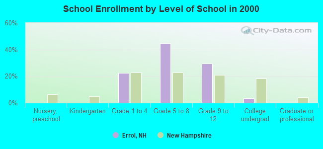
Public elementary/middle school in Errol:
- ERROL CONSOLIDATED ELEMENTARY SCHOOL (Students: 21, Location: 99 MAIN ST., Grades: KG-8)
Points of interest:
Notable locations in Errol: Mollidgewock Campground (A), Errol Fire Department (B), Errol Emergency Medical Services (C). Display/hide their locations on the map
Lakes, reservoirs, and swamps: Bear Brook Pond (A), Leonard Pond (B), Long Pond (C), Mountain Pond (D), Munn Pond (E), Round Pond Lake (F), Signal Pond (G), Sweat Pond (H). Display/hide their locations on the map
Streams, rivers, and creeks: Smoky Camp Brook (A), Mollidgewock Brook (B), Millsfield Pond Brook (C), Greenough Brook (D), Corser Brook (E), Clear Stream (F), Bear Brook (G). Display/hide their locations on the map
Parks in Errol include: Lake Umbagog National Wildlife Refuge (1), Umbagog National Wildlife Refuge (2), Androscoggin Wayside Park (3). Display/hide their locations on the map
Drinking water stations with addresses in Errol and their reported violations in the past:
ERROL WATER WORKS/WEST (Population served: 175, Groundwater):Past health violations:TRADING POST CAFE (Serves ME, Population served: 120, Groundwater):Past monitoring violations:
- MCL, Monthly (TCR) - In JUN-2014, Contaminant: Coliform. Follow-up actions: St Violation/Reminder Notice (JUN-24-2014), St Public Notif requested (JUN-24-2014)
- MCL, Monthly (TCR) - In MAY-2013, Contaminant: Coliform. Follow-up actions: St Public Notif requested (MAY-22-2013), St Violation/Reminder Notice (MAY-22-2013), St Public Notif received (JUL-12-2013), St Compliance achieved (NOV-19-2013)
- MCL, Monthly (TCR) - In APR-2013, Contaminant: Coliform. Follow-up actions: St Public Notif requested (MAY-01-2013), St Violation/Reminder Notice (MAY-01-2013), St Public Notif received (MAY-10-2013), St Compliance achieved (NOV-19-2013)
- MCL, Monthly (TCR) - In NOV-2012, Contaminant: Coliform. Follow-up actions: St Public Notif requested (NOV-26-2012), St Violation/Reminder Notice (NOV-26-2012), St Public Notif received (JAN-24-2013), St Compliance achieved (NOV-19-2013)
- MCL, Monthly (TCR) - In SEP-2012, Contaminant: Coliform. Follow-up actions: St Public Notif requested (SEP-19-2012), St Violation/Reminder Notice (SEP-19-2012), St Public Notif received (SEP-27-2012), St Compliance achieved (NOV-19-2013)
- MCL, Monthly (TCR) - In AUG-2012, Contaminant: Coliform. Follow-up actions: St Public Notif requested (AUG-22-2012), St Violation/Reminder Notice (AUG-22-2012), St Formal NOV issued (SEP-19-2012), St Public Notif received (SEP-27-2012), St Compliance achieved (NOV-19-2013)
- MCL, Monthly (TCR) - In JUL-2012, Contaminant: Coliform. Follow-up actions: St Public Notif requested (JUL-24-2012), St Violation/Reminder Notice (JUL-24-2012), St Public Notif received (AUG-08-2012), St Formal NOV issued (SEP-19-2012), St Compliance achieved (NOV-19-2013)
- Monitoring, Source Water (GWR) - Between JUL-18-2012 and AUG-18-2012, Contaminant: E. COLI. Follow-up actions: St Public Notif requested (SEP-12-2012), St Violation/Reminder Notice (SEP-12-2012), St Compliance achieved (SEP-25-2012), St Public Notif received (SEP-27-2012)
- One regular monitoring violation
Past monitoring violations:BOSEBUCK MOUNTAIN CAMPS (Serves ME, Population served: 92, Groundwater):
- 4 routine major monitoring violations
Past monitoring violations:WENTWORTHS LOCATION (Population served: 32, Groundwater):
- 3 routine major monitoring violations
- One regular monitoring violation
Past health violations:Past monitoring violations:
- MCL, Monthly (TCR) - In AUG-2012, Contaminant: Coliform. Follow-up actions: St Public Notif requested (AUG-27-2012), St Violation/Reminder Notice (AUG-27-2012), St Public Notif received (AUG-30-2012), St Formal NOV issued (OCT-31-2012), St Compliance achieved (APR-01-2013)
- MCL, Acute (TCR) - In SEP-2011, Contaminant: Coliform. Follow-up actions: St Public Notif requested (SEP-29-2011), St Violation/Reminder Notice (SEP-29-2011), St Public Notif received (OCT-31-2011), St Formal NOV issued (MAR-02-2012), St Compliance achieved (APR-16-2012)
- MCL, Monthly (TCR) - In MAY-2011, Contaminant: Coliform. Follow-up actions: St Public Notif requested (JUN-01-2011), St Violation/Reminder Notice (JUN-01-2011), St Public Notif received (AUG-08-2011), St Formal NOV issued (MAR-02-2012), St Compliance achieved (APR-16-2012)
- MCL, Monthly (TCR) - In OCT-2006, Contaminant: Coliform. Follow-up actions: St Violation/Reminder Notice (NOV-14-2006), St Compliance achieved (APR-12-2007)
- MCL, Acute (TCR) - In SEP-2006, Contaminant: Coliform. Follow-up actions: St Public Notif received (SEP-21-2006), St Public Notif requested (SEP-25-2006), St Violation/Reminder Notice (SEP-25-2006), St Compliance achieved (APR-12-2007)
- Monitoring, Source Water (GWR) - Between SEP-26-2012 and OCT-26-2012, Contaminant: E. COLI. Follow-up actions: St Public Notif requested (NOV-05-2012), St Violation/Reminder Notice (NOV-05-2012), St Compliance achieved (NOV-05-2012), St Public Notif received (NOV-26-2012)
- Monitoring, Source Water (GWR) - Between JUN-23-2012 and JUL-23-2012, Contaminant: E. COLI. Follow-up actions: St Public Notif requested (JUL-12-2012), St Violation/Reminder Notice (JUL-12-2012), St Compliance achieved (JUL-18-2012), St Public Notif received (JUL-24-2012)
- Monitoring, Repeat Major (TCR) - In JUN-2012, Contaminant: Coliform (TCR). Follow-up actions: St Public Notif requested (JUL-12-2012), St Violation/Reminder Notice (JUL-12-2012), St Compliance achieved (JUL-12-2012), St Public Notif received (JUL-24-2012)
- 8 routine major monitoring violations
- One minor monitoring violation
| This town: | 1.9 people |
| New Hampshire: | 2.5 people |
| This town: | 51.7% |
| Whole state: | 66.3% |
| This town: | 14.6% |
| Whole state: | 8.3% |
Likely homosexual households (counted as self-reported same-sex unmarried-partner households)
- Lesbian couples: 0.7% of all households
- Gay men: 0.0% of all households
| This town: | 13.1% |
| Whole state: | 6.5% |
| This town: | 0.6% |
| Whole state: | 2.8% |
3 people in other group homes in 2000
For population 15 years and over in Errol:
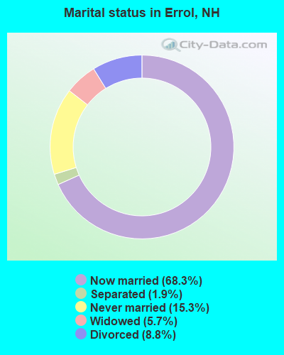
- Never married: 15.3%
- Now married: 68.3%
- Separated: 1.9%
- Widowed: 5.7%
- Divorced: 8.8%
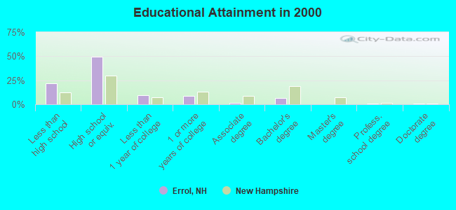
For population 25 years and over in Errol:
- High school or higher: 78.5%
- Bachelor's degree or higher: 8.5%
- Graduate or professional degree: 1.6%
- Unemployed: 3.6%
- Mean travel time to work (commute): 34.3 minutes
| Here: | 8.6 |
| New Hampshire average: | 10.9 |
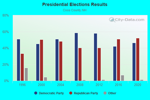
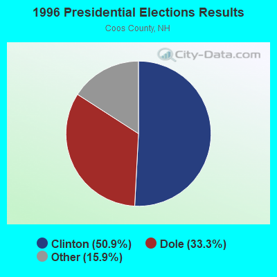
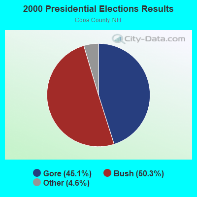

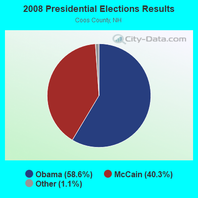


Graphs represent county-level data. Detailed 2008 Election Results
Religion statistics for Errol, NH (based on Coos County data)
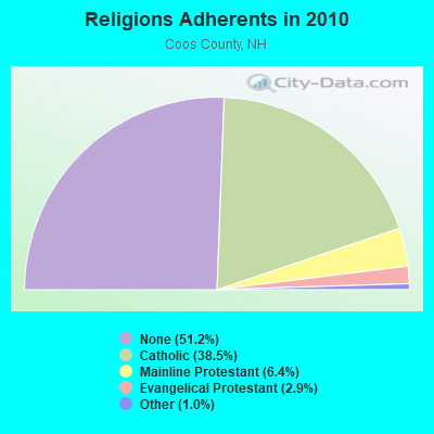
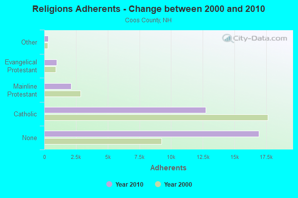
| Religion | Adherents | Congregations |
|---|---|---|
| Catholic | 12,710 | 5 |
| Mainline Protestant | 2,105 | 23 |
| Evangelical Protestant | 966 | 14 |
| Other | 323 | 7 |
| Orthodox | 26 | 1 |
| None | 16,925 | - |
Food Environment Statistics:
| Coos County: | 4.33 / 10,000 pop. |
| State: | 2.14 / 10,000 pop. |
| Coos County: | 0.93 / 10,000 pop. |
| New Hampshire: | 1.78 / 10,000 pop. |
| This county: | 9.28 / 10,000 pop. |
| New Hampshire: | 4.02 / 10,000 pop. |
| Coos County: | 12.68 / 10,000 pop. |
| New Hampshire: | 9.70 / 10,000 pop. |
| This county: | 9.7% |
| New Hampshire: | 7.6% |
| Coos County: | 26.9% |
| New Hampshire: | 24.4% |
| Coos County: | 9.7% |
| New Hampshire: | 15.9% |
Strongest AM radio stations in Errol:
- WTME (780 AM; 10 kW; RUMFORD, ME; Owner: MOUNTAIN VALLEY BROADCASTING, INC.)
- WCHP (760 AM; 35 kW; CHAMPLAIN, NY; Owner: CHAMPLAIN RADIO, INC.)
- WRKO (680 AM; 50 kW; BOSTON, MA; Owner: ENTERCOM BOSTON LICENSE, LLC)
- WEEI (850 AM; 50 kW; BOSTON, MA; Owner: ENTERCOM BOSTON LICENSE, LLC)
- WNNZ (640 AM; 50 kW; WESTFIELD, MA; Owner: CLEAR CHANNEL BROADCASTING LICENSES, INC.)
- WCRN (830 AM; 50 kW; WORCESTER, MA; Owner: CARTER BROADCASTING CORPORATION)
- WSKW (1160 AM; 10 kW; SKOWHEGAN, ME; Owner: MOUNTAIN WIRELESS, INCORPORATED)
- WMOU (1230 AM; 1 kW; BERLIN, NH; Owner: JERICHO BROADCASTING COMPANY, L.L.C.)
- WMTW (870 AM; 10 kW; GORHAM, ME; Owner: RADIO PARTNERS OF MAINE, L.P.)
- WBZ (1030 AM; 50 kW; BOSTON, MA; Owner: INFINITY BROADCASTING OPERATIONS, INC.)
- WGY (810 AM; 50 kW; SCHENECTADY, NY; Owner: CLEAR CHANNEL BROADCASTING LICENSES, INC.)
- WICY (1490 AM; 50 kW; MALONE, NY; Owner: CARTIER COMMUNICATIONS INC.)
- WKOX (1200 AM; 50 kW; FRAMINGHAM, MA; Owner: CAPSTAR TX LIMITED PARTNERSHIP)
Strongest FM radio stations in Errol:
- WPKQ (103.7 FM; NORTH CONWAY, NH; Owner: CITADEL BROADCASTING COMPANY)
- WHOM (94.9 FM; MT. WASHINGTON, NH; Owner: CITADEL BROADCASTING COMPANY)
- WLOB-FM (96.3 FM; RUMFORD, ME; Owner: ATLANTIC COAST RADIO, LLC)
- WTOS-FM (105.1 FM; SKOWHEGAN, ME; Owner: CAPSTAR TX LIMITED PARTNERSHIP)
- WTBM (100.7 FM; MEXICO, ME; Owner: MOUNTAIN VALLEY BROADCASTING, INC.)
- WGMT (97.7 FM; LYNDON, VT; Owner: VERMONT BROADCAST ASSOCIATES, INC.)
- WMTK (106.3 FM; LITTLETON, NH; Owner: VERMONT BROADCAST ASSOCIATES, INC.)
- WVFM (105.7 FM; CAMPTON, NH; Owner: DEVON BROADCASTING COMPANY, INC.)
- WXXS (102.3 FM; LANCASTER, NH; Owner: BARRY P. LUNDERVILLE)
- Errol, New Hampshire
- Fatal accident count10
- Vehicles involved in fatal accidents10
- Fatal accidents involving drunk persons:4
- Fatalities12
- Persons involved in fatal accidents19
- Pedestrians involved in fatal accidents1
- New Hampshire average
- Fatal accident count1005
- Vehicles involved in fatal accidents1506
- Fatal accidents involving drunk persons376
- Fatalities1099
- Persons involved in fatal accidents2319
- Pedestrians involved in fatal accidents96
- National Bridge Inventory (NBI) Statistics
- 5Number of bridges
- 52ft / 16.4mTotal length
- $15,710,000Total costs
- 4,739Total average daily traffic
- 345Total average daily truck traffic
- 7,011Total future (year 2042) average daily traffic
FCC Registered Antenna Towers:
21 (See the full list of FCC Registered Antenna Towers in Errol)FCC Registered Private Land Mobile Towers:
1- Errol Fire Dept (Lat: 44.780333 Lon: -71.135611), Type: Bant, Structure height: 16.3 m, Overall height: 18.3 m, Call Sign: WQRB600,
Assigned Frequencies: 157.740 MHz, Grant Date: 03/14/2023, Expiration Date: 04/10/2033, Certifier: John Suker, Registrant: Cara Enterprises Inc, Las Vegas, NV 89140-0124, Phone: (702) 838-9728, Fax: (702) 363-4607, Email:
FCC Registered Broadcast Land Mobile Towers:
3- Mollidgewock St Park, 1437 Berlin Road (Lat: 44.743500 Lon: -71.145361), Type: Bant, Structure height: 9.1 m, Call Sign: KCA208,
Assigned Frequencies: 31.9000 MHz, Grant Date: 08/23/2022, Expiration Date: 11/18/2032, Registrant: Nh Dncr, 172 Pembroke Road, Concord, NH 03301, Phone: (603) 271-2654, Fax: (603) 271-6488, Email:
- Lat: 44.786556 Lon: -71.124028, Call Sign: WQNN719,
Assigned Frequencies: 158.160 MHz, Grant Date: 02/19/2021, Expiration Date: 04/21/2030, Certifier: Richard T Cole, Registrant: Brookfield Renewable, 150 Main Street, Lewiston, ME 04240, Phone: (207) 755-5601, Fax: (717) 334-6440, Email:
- Lat: 44.753667 Lon: -71.298944, Call Sign: WQNV344,
Assigned Frequencies: 451.337 MHz, 451.387 MHz, 451.387 MHz, 451.562 MHz, 451.562 MHz, 452.037 MHz, 452.037 MHz, 452.187 MHz, 452.187 MHz, 452.412 MHz... (+9 more), Grant Date: 04/19/2021, Expiration Date: 06/21/2030, Certifier: Glen E Cox, Registrant: Florida Power & Light Co, 6445 Nw 72nd Ave, Miami, FL 33166, Phone: (305) 552-4041, Email:
FCC Registered Microwave Towers:
1- Signal Ridge Road, Signal Ridge Road (Lat: 44.787778 Lon: -71.202944), Type: Upole, Structure height: 22.9 m, Call Sign: WRMV600,
Assigned Frequencies: 10995.0 MHz, 10995.0 MHz, 10995.0 MHz, 10995.0 MHz, 10995.0 MHz, 10995.0 MHz, 10995.0 MHz, 10995.0 MHz, Grant Date: 06/10/2021, Expiration Date: 06/10/2031, Certifier: Donald Dawson, Registrant: Intelpath, Hinsdale, IL 60522, Phone: (312) 841-9188, Email:
FCC Registered Maritime Coast & Aviation Ground Towers:
2- Errol Airport (Lat: 44.787556 Lon: -71.157861), Type: Building, Overall height: 5 m, Call Sign: WMT3, Licensee ID: L00008549,
Assigned Frequencies: 122.800 MHz, Grant Date: 09/21/2004, Expiration Date: 09/21/2014, Cancellation Date: 11/22/2014, Registrant: State Of New Hampshire, Department Of Transportation, Division Of Aeronautics, Seven Hazen Drive, Concord, NH 03301-0483, Phone: (603) 271-2552, Fax: (603) 271-1689
- Colebrook Road (Lat: 44.787556 Lon: -71.157861), Type: Building, Structure height: 15 m, Overall height: 15.5 m, Call Sign: WRCP664, Licensee ID: L00008549,
Assigned Frequencies: 122.800 MHz, Grant Date: 11/28/2018, Expiration Date: 11/28/2028, Certifier: Katherine A Schmitt, Registrant: State Of New Hampshire, Department Of Transportation, Bureau Of Aeronautics, Seven Hazen Drive, Concord, NH 03302-0483, Phone: (603) 271-2552, Fax: (603) 271-1689, Email:
FCC Registered Amateur Radio Licenses:
7- Call Sign: KA1AUK, Grant Date: 02/02/1988, Expiration Date: 02/02/1998, Cancellation Date: 02/03/2000, Registrant: Neal A Wells Jr, Errol, NH 03579
- Call Sign: N1VZY, Grant Date: 03/11/1996, Expiration Date: 10/19/2005, Cancellation Date: 10/20/2007, Registrant: Leo P Cellupica, Errol, NH 03579
- Call Sign: W1YZN, Grant Date: 02/22/1994, Expiration Date: 02/22/2004, Cancellation Date: 02/23/2006, Registrant: Vernon J Le Duc Sr, Rt 26w, Errol, NH 03579
- Call Sign: KB1MEG, Licensee ID: L00997920, Grant Date: 01/28/2015, Expiration Date: 03/30/2025, Certifier: John D Mcewan, Registrant: John D Mcewan, Errol, NH 03579
- Call Sign: KB1NJN, Licensee ID: L01134944, Grant Date: 03/30/2006, Expiration Date: 03/30/2016, Cancellation Date: 03/31/2018, Certifier: Gladys I Mcewan, Registrant: Gladys I Mcewan, Errol, NH 03579
- Call Sign: KC1PGC, Licensee ID: L02444984, Grant Date: 04/30/2021, Expiration Date: 04/30/2031, Cancellation Date: 03/22/2022, Certifier: Eric C Ward, Registrant: Eric C Ward, Errol, NH 03579
- Call Sign: W1ECW, Previous Call Sign: KC1PGC, Licensee ID: L02444984, Grant Date: 03/22/2022, Expiration Date: 03/22/2032, Certifier: Eric C Ward, Registrant: Eric C Ward, Errol, NH 03579
FAA Registered Aircraft:
1- Aircraft: PIPER PA-12 (Category: Land, Seats: 3, Weight: Up to 12,499 Pounds, Speed: 82 mph), Engine: LYCOMING 0-235 SERIES (115 HP) (Reciprocating)
N-Number: 7900H, N7900H, N-7900H, Serial Number: 12-804, Year manufactured: 1946, Airworthiness Date: 07/07/1956, Certificate Issue Date: 11/03/1970
Registrant (Individual): David Cressler Heasley, Po Box 43, Errol, NH 03579
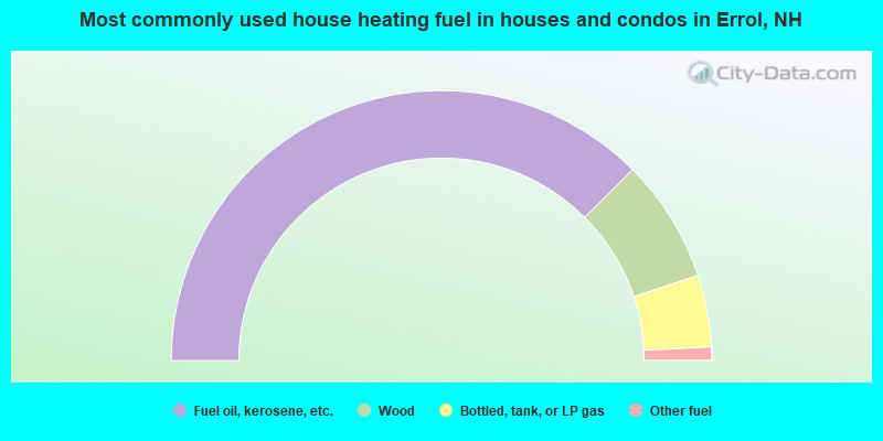
- 75.0%Fuel oil, kerosene, etc.
- 14.8%Wood
- 8.6%Bottled, tank, or LP gas
- 1.6%Other fuel
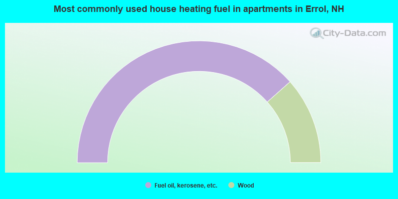
- 76.9%Fuel oil, kerosene, etc.
- 23.1%Wood
Errol compared to New Hampshire state average:
- Median household income below state average.
- Median house value below state average.
- Unemployed percentage significantly below state average.
- Black race population percentage above state average.
- Hispanic race population percentage significantly below state average.
- Median age significantly above state average.
- Renting percentage below state average.
- Length of stay since moving in significantly above state average.
- Number of rooms per house significantly below state average.
- House age significantly below state average.
- Number of college students significantly below state average.
- Percentage of population with a bachelor's degree or higher significantly below state average.