Clarksville, New Hampshire
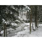
Submit your own pictures of this town and show them to the world
- OSM Map
- Google Map
- MSN Map
Population change since 2000: -9.9%
 |
| Males: 137 | |
| Females: 128 |
| Median resident age: | 53.8 years |
| New Hampshire median age: | 43.9 years |
Zip codes: 03592.
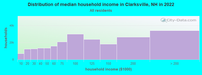
| Clarksville: | $65,458 |
| NH: | $89,992 |
Estimated per capita income in 2022: $34,951 (it was $18,090 in 2000)
Clarksville town income, earnings, and wages data
Estimated median house or condo value in 2022: $204,118 (it was $78,500 in 2000)
| Clarksville: | $204,118 |
| NH: | $384,700 |
Mean prices in 2022: all housing units: $223,643; detached houses: $241,655; townhouses or other attached units: $431,348; in 2-unit structures: $202,937; in 3-to-4-unit structures: $301,182; in 5-or-more-unit structures: $411,054; mobile homes: $86,091
Detailed information about poverty and poor residents in Clarksville, NH


- 26098.1%White alone
- 41.5%Two or more races
- 10.4%American Indian alone
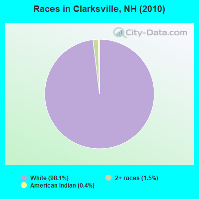
Races in Clarksville detailed stats: ancestries, foreign born residents, place of birth
According to our research of New Hampshire and other state lists, there was 1 registered sex offender living in Clarksville, New Hampshire as of May 17, 2024.
The ratio of all residents to sex offenders in Clarksville is 265 to 1.
 Recent articles from our blog. Our writers, many of them Ph.D. graduates or candidates, create easy-to-read articles on a wide variety of topics.
Ancestries: English (37.4%), French (22.8%), Irish (12.2%), French Canadian (7.5%), Scottish (6.5%), United States (6.5%).
Current Local Time: EST time zone
Incorporated in 1853
Land area: 60.2 square miles.
Population density: 4.4 people per square mile (very low).
11 residents are foreign born (3.7% North America).
| This town: | 3.7% |
| New Hampshire: | 4.4% |
| Clarksville town: | 2.1% ($1,654) |
| New Hampshire: | 2.3% ($2,946) |
Nearest city with pop. 50,000+: Portland, ME  (107.9 miles , pop. 64,249).
Nearest city with pop. 200,000+: Boston, MA (186.2 miles , pop. 589,141).
Nearest city with pop. 1,000,000+: Bronx, NY (313.9 miles , pop. 1,332,650).
Nearest cities:
), ), ), )Latitude: 45.00 N, Longitude: 71.39 W
Area code commonly used in this area: 603
| Here: | 3.7% |
| New Hampshire: | 2.5% |
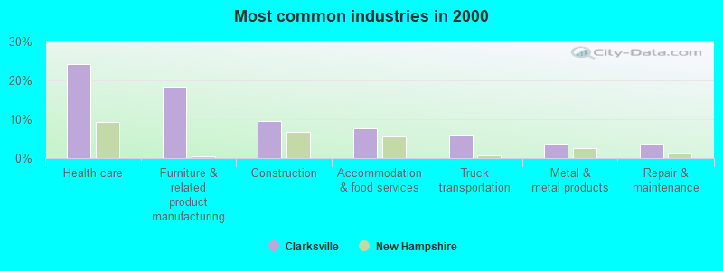
- Health care (24.2%)
- Furniture & related product manufacturing (18.5%)
- Construction (9.6%)
- Accommodation & food services (7.6%)
- Truck transportation (5.7%)
- Metal & metal products (3.8%)
- Repair & maintenance (3.8%)
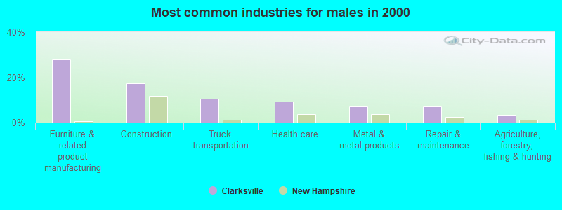
- Furniture & related product manufacturing (27.9%)
- Construction (17.4%)
- Truck transportation (10.5%)
- Health care (9.3%)
- Metal & metal products (7.0%)
- Repair & maintenance (7.0%)
- Agriculture, forestry, fishing & hunting (3.5%)
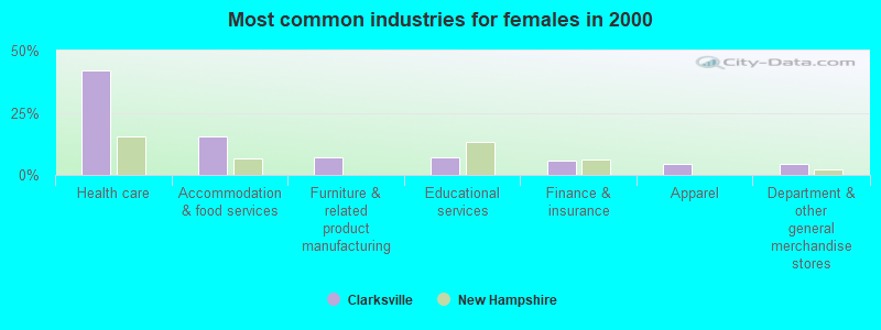
- Health care (42.3%)
- Accommodation & food services (15.5%)
- Furniture & related product manufacturing (7.0%)
- Educational services (7.0%)
- Finance & insurance (5.6%)
- Apparel (4.2%)
- Department & other general merchandise stores (4.2%)
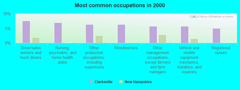
- Driver/sales workers and truck drivers (7.6%)
- Nursing, psychiatric, and home health aides (7.0%)
- Other production occupations, including supervisors (6.4%)
- Woodworkers (6.4%)
- Other management occupations, except farmers and farm managers (5.7%)
- Vehicle and mobile equipment mechanics, installers, and repairers (5.7%)
- Registered nurses (5.1%)
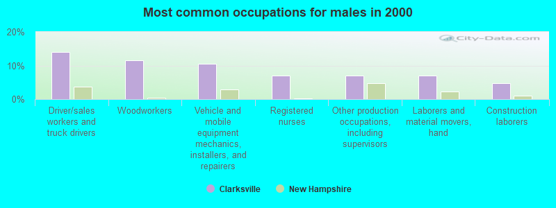
- Driver/sales workers and truck drivers (14.0%)
- Woodworkers (11.6%)
- Vehicle and mobile equipment mechanics, installers, and repairers (10.5%)
- Registered nurses (7.0%)
- Other production occupations, including supervisors (7.0%)
- Laborers and material movers, hand (7.0%)
- Construction laborers (4.7%)
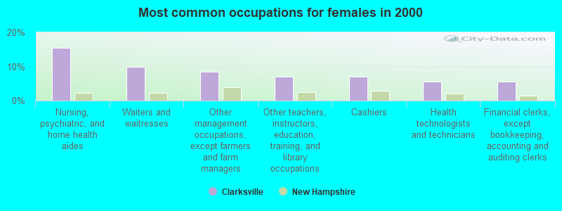
- Nursing, psychiatric, and home health aides (15.5%)
- Waiters and waitresses (9.9%)
- Other management occupations, except farmers and farm managers (8.5%)
- Other teachers, instructors, education, training, and library occupations (7.0%)
- Cashiers (7.0%)
- Health technologists and technicians (5.6%)
- Financial clerks, except bookkeeping, accounting and auditing clerks (5.6%)
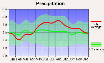
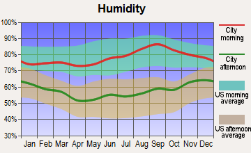
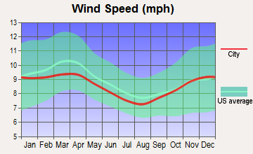
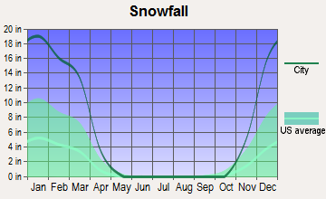
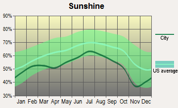
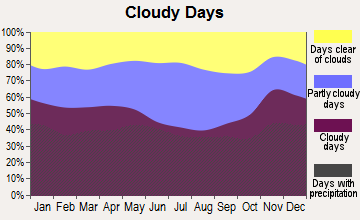
Average climate in Clarksville, New Hampshire
Based on data reported by over 4,000 weather stations

Earthquake activity:
Clarksville-area historical earthquake activity is significantly above New Hampshire state average. It is 78% smaller than the overall U.S. average.On 4/20/2002 at 10:50:47, a magnitude 5.3 (5.3 ML, Depth: 3.0 mi, Class: Moderate, Intensity: VI - VII) earthquake occurred 118.4 miles away from the city center
On 4/20/2002 at 10:50:47, a magnitude 5.2 (5.2 MB, 4.2 MS, 5.2 MW, 5.0 MW) earthquake occurred 119.9 miles away from Clarksville center
On 10/7/1983 at 10:18:46, a magnitude 5.3 (5.1 MB, 5.3 LG, 5.1 ML) earthquake occurred 162.9 miles away from the city center
On 10/16/2012 at 23:12:25, a magnitude 4.7 (4.7 ML, Depth: 10.0 mi, Class: Light, Intensity: IV - V) earthquake occurred 103.9 miles away from Clarksville center
On 1/19/1982 at 00:14:42, a magnitude 4.7 (4.5 MB, 4.7 MD, 4.5 LG) earthquake occurred 104.6 miles away from Clarksville center
On 6/16/1995 at 12:13:11, a magnitude 3.8 (3.8 LG, Depth: 3.1 mi, Class: Light, Intensity: II - III) earthquake occurred 56.1 miles away from Clarksville center
Magnitude types: regional Lg-wave magnitude (LG), body-wave magnitude (MB), duration magnitude (MD), local magnitude (ML), surface-wave magnitude (MS), moment magnitude (MW)
Natural disasters:
The number of natural disasters in Coos County (22) is greater than the US average (15).Major Disasters (Presidential) Declared: 11
Emergencies Declared: 9
Causes of natural disasters: Floods: 9, Storms: 9, Hurricanes: 3, Snows: 2, Winter Storms: 2, Blizzard: 1, Ice Storm: 1, Snowfall: 1, Snowstorm: 1, Tropical Storm: 1, Wind: 1, Other: 1 (Note: some incidents may be assigned to more than one category).
Colleges/universities with over 2000 students nearest to Clarksville:
- University of Maine at Farmington (about 66 miles; Farmington, ME; Full-time enrollment: 2,036)
- Norwich University (about 87 miles; Northfield, VT; FT enrollment: 4,221)
- Plymouth State University (about 88 miles; Plymouth, NH; FT enrollment: 4,838)
- University of Maine at Augusta (about 91 miles; Augusta, ME; FT enrollment: 3,204)
- Saint Joseph's College of Maine (about 93 miles; Standish, ME; FT enrollment: 2,010)
- Saint Michael's College (about 95 miles; Colchester, VT; FT enrollment: 2,336)
- Community College of Vermont (about 95 miles; Winooski, VT; FT enrollment: 3,394)
Points of interest:
Notable locations in Clarksville: Clarksville Town Hall (A), Felton Camp (B), Hurlbert Camp (C). Display/hide their locations on the map
Lakes and reservoirs: Beaver Pond (A), Carr Pond (B), Clarksville Pond (C), Judd Pond (D), Judds Ponds (E), Shehan Pond (F), Lake Francis (G). Display/hide their locations on the map
Streams, rivers, and creeks: Labrador Brook (A), Rowell Brook (B), Cedar Stream (C), Pisgah Brook (D), Kidder Brook (E), Hellgate Brook (F), Ferguson Brook (G), Favreau Brook (H), Dead Water Stream (I). Display/hide their locations on the map
Park in Clarksville: Lake Francis Wildlife Area (1). Display/hide its location on the map
Drinking water stations with addresses in Clarksville and their reported violations in the past:
RUDYS CABINS AND CAMPGROUND (Address: 57 RUDY LN , Population served: 115, Groundwater):Past health violations:Past monitoring violations:
- MCL, Monthly (TCR) - Between APR-2014 and JUN-2014, Contaminant: Coliform. Follow-up actions: St Public Notif requested (MAY-27-2014), St Violation/Reminder Notice (MAY-27-2014), St Public Notif received (JUN-02-2014)
- MCL, Monthly (TCR) - Between APR-2013 and JUN-2013, Contaminant: Coliform. Follow-up actions: St Public Notif requested (JUN-10-2013), St Violation/Reminder Notice (JUN-10-2013), St Public Notif received (JUN-21-2013), St Compliance achieved (NOV-12-2013)
- MCL, Monthly (TCR) - Between JUL-2012 and SEP-2012, Contaminant: Coliform. Follow-up actions: St Public Notif requested (AUG-27-2012), St Violation/Reminder Notice (AUG-27-2012), St Public Notif received (SEP-07-2012), St Formal NOV issued (OCT-25-2012), St Compliance achieved (OCT-03-2013)
- Monitoring, Repeat Major (TCR) - Between JUL-2013 and SEP-2013, Contaminant: Coliform (TCR). Follow-up actions: St Public Notif requested (SEP-30-2013), St Violation/Reminder Notice (SEP-30-2013), St Compliance achieved (SEP-30-2013), St Public Notif received (OCT-07-2013)
| This town: | 2.1 people |
| New Hampshire: | 2.5 people |
| This town: | 66.1% |
| Whole state: | 66.3% |
| This town: | 8.7% |
| Whole state: | 8.3% |
No gay or lesbian households reported
| This town: | 3.7% |
| Whole state: | 6.5% |
| This town: | 2.3% |
| Whole state: | 2.8% |
For population 15 years and over in Clarksville:
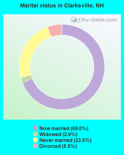
- Never married: 23.5%
- Now married: 69.0%
- Separated: 0.0%
- Widowed: 2.0%
- Divorced: 5.5%
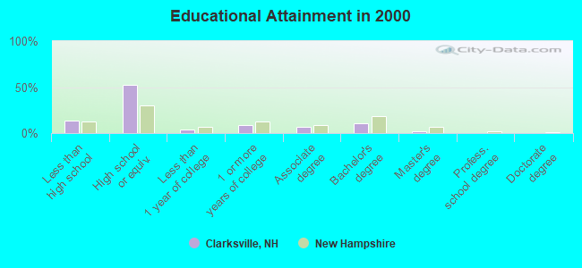
For population 25 years and over in Clarksville:
- High school or higher: 86.0%
- Bachelor's degree or higher: 13.1%
- Graduate or professional degree: 2.2%
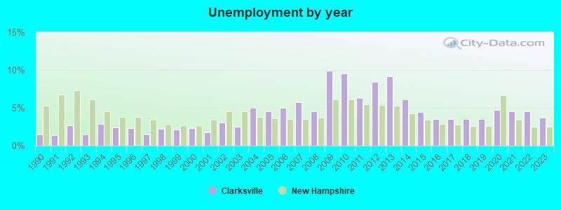
- Unemployed: 3.7%
- Mean travel time to work (commute): 20.1 minutes
| Here: | 9.1 |
| New Hampshire average: | 10.9 |
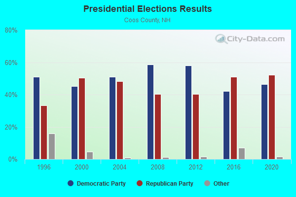
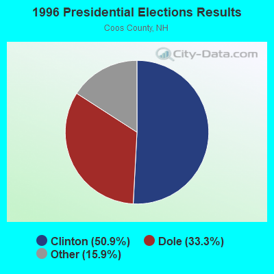
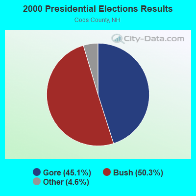
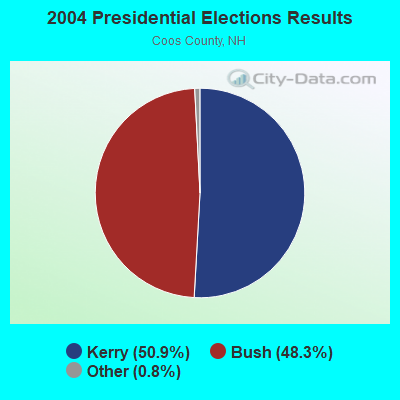
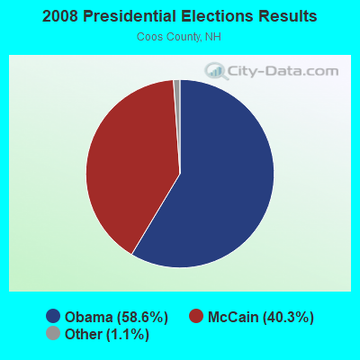
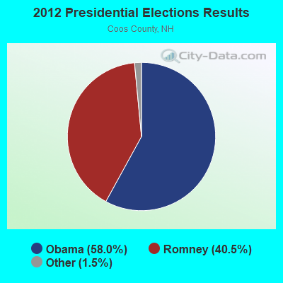
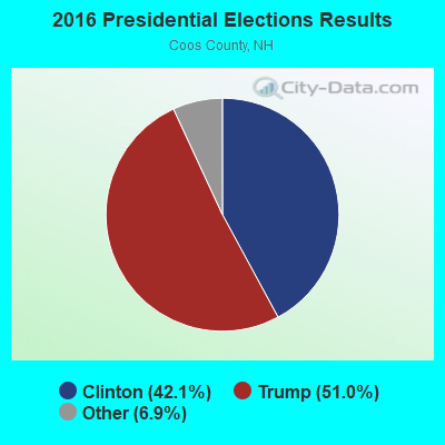
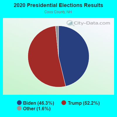
Graphs represent county-level data. Detailed 2008 Election Results
Religion statistics for Clarksville, NH (based on Coos County data)
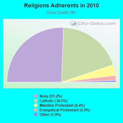
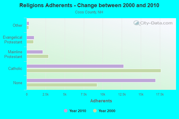
| Religion | Adherents | Congregations |
|---|---|---|
| Catholic | 12,710 | 5 |
| Mainline Protestant | 2,105 | 23 |
| Evangelical Protestant | 966 | 14 |
| Other | 323 | 7 |
| Orthodox | 26 | 1 |
| None | 16,925 | - |
Food Environment Statistics:
| Here: | 4.33 / 10,000 pop. |
| State: | 2.14 / 10,000 pop. |
| Here: | 0.93 / 10,000 pop. |
| New Hampshire: | 1.78 / 10,000 pop. |
| This county: | 9.28 / 10,000 pop. |
| New Hampshire: | 4.02 / 10,000 pop. |
| This county: | 12.68 / 10,000 pop. |
| New Hampshire: | 9.70 / 10,000 pop. |
| This county: | 9.7% |
| State: | 7.6% |
| Here: | 26.9% |
| New Hampshire: | 24.4% |
| Coos County: | 9.7% |
| New Hampshire: | 15.9% |
Strongest AM radio stations in Clarksville:
- WCHP (760 AM; 35 kW; CHAMPLAIN, NY; Owner: CHAMPLAIN RADIO, INC.)
- WTME (780 AM; 10 kW; RUMFORD, ME; Owner: MOUNTAIN VALLEY BROADCASTING, INC.)
- WRKO (680 AM; 50 kW; BOSTON, MA; Owner: ENTERCOM BOSTON LICENSE, LLC)
- WICY (1490 AM; 50 kW; MALONE, NY; Owner: CARTIER COMMUNICATIONS INC.)
- WNNZ (640 AM; 50 kW; WESTFIELD, MA; Owner: CLEAR CHANNEL BROADCASTING LICENSES, INC.)
- WEEI (850 AM; 50 kW; BOSTON, MA; Owner: ENTERCOM BOSTON LICENSE, LLC)
- WCRN (830 AM; 50 kW; WORCESTER, MA; Owner: CARTER BROADCASTING CORPORATION)
- WGY (810 AM; 50 kW; SCHENECTADY, NY; Owner: CLEAR CHANNEL BROADCASTING LICENSES, INC.)
- WBZ (1030 AM; 50 kW; BOSTON, MA; Owner: INFINITY BROADCASTING OPERATIONS, INC.)
- WDEV (550 AM; 5 kW; WATERBURY, VT; Owner: RADIO VERMONT, INC.)
- WSKW (1160 AM; 10 kW; SKOWHEGAN, ME; Owner: MOUNTAIN WIRELESS, INCORPORATED)
- WKOX (1200 AM; 50 kW; FRAMINGHAM, MA; Owner: CAPSTAR TX LIMITED PARTNERSHIP)
- WALE (990 AM; 50 kW; GREENVILLE, RI; Owner: NORTH AMERICAN BROADCASTING CO., INC.)
Strongest FM radio stations in Clarksville:
- WPKQ (103.7 FM; NORTH CONWAY, NH; Owner: CITADEL BROADCASTING COMPANY)
- WHOM (94.9 FM; MT. WASHINGTON, NH; Owner: CITADEL BROADCASTING COMPANY)
- WGMT (97.7 FM; LYNDON, VT; Owner: VERMONT BROADCAST ASSOCIATES, INC.)
- WTOS-FM (105.1 FM; SKOWHEGAN, ME; Owner: CAPSTAR TX LIMITED PARTNERSHIP)
- WLOB-FM (96.3 FM; RUMFORD, ME; Owner: ATLANTIC COAST RADIO, LLC)
- WTBM (100.7 FM; MEXICO, ME; Owner: MOUNTAIN VALLEY BROADCASTING, INC.)
- WMTK (106.3 FM; LITTLETON, NH; Owner: VERMONT BROADCAST ASSOCIATES, INC.)
- WMOO (92.1 FM; DERBY CENTER, VT; Owner: NORTHSTAR MEDIA, INC.)
TV broadcast stations around Clarksville:
- W18BO (Channel 18; PITTSBURG, NH; Owner: UNIVERSITY OF NEW HAMPSHIRE)
- National Bridge Inventory (NBI) Statistics
- 3Number of bridges
- 36ft / 11.0mTotal length
- $9,426,000Total costs
- 1,928Total average daily traffic
- 109Total average daily truck traffic
- 2,851Total future (year 2042) average daily traffic
FCC Registered Antenna Towers:
1- 1200' W Of Rt 145 (Lat: 45.012500 Lon: -71.419722), Type: 37.0, Overall height: 3 m, Registrant: Us Border Patrol, Richard.W.Mcvicker@usdot.Gov, , 705 Swant-on, Phone: (802) 868-3361
FCC Registered Broadcast Land Mobile Towers:
5- Ben Young Hill (Lat: 45.022000 Lon: -71.417028), Call Sign: KFF360,
Assigned Frequencies: 460.300 MHz, 460.150 MHz, Grant Date: 01/25/2023, Expiration Date: 03/30/2033, Registrant: State Of Vermont, 45 State Drive, Watterbury, VT 05671, Phone: (802) 229-0882, Fax: (802) 241-5557, Email:
- BEN YOUNG HILL, 1200 W Of Rt 145 (Lat: 45.012500 Lon: -71.419722), Type: Tower, Structure height: 3 m, Overall height: 37 m, Call Sign: WQIQ913,
Assigned Frequencies: 453.212 MHz, 453.212 MHz, 453.462 MHz, 453.462 MHz, 453.712 MHz, 453.712 MHz, 453.862 MHz, 453.862 MHz, Grant Date: 02/22/2018, Expiration Date: 04/17/2028, Certifier: Terry Lavalley, Registrant: State Of Vermont, 45 State Drive, Watterbury, VT 05671, Phone: (802) 229-0882, Fax: (407) 302-2293, Email:
- BEN YOUNG HILL, 1200 W Of Rt 145 (Lat: 45.012500 Lon: -71.419722), Type: Gtower, Structure height: 3 m, Overall height: 37 m, Call Sign: WQIY991,
Assigned Frequencies: 155.752 MHz, 151.137 MHz, 151.137 MHz, Grant Date: 05/22/2018, Expiration Date: 06/25/2028, Certifier: Terry Lavalley, Registrant: State Of Vermont, 45 State Drive, Watterbury, VT 05671, Phone: (802) 229-0882, Fax: (802) 241-5553, Email:
- BEN YOUNG HILL, Ben Young Hill Road (Lat: 45.022000 Lon: -71.417028), Type: Gtower, Structure height: 20 m, Overall height: 36.6 m, Call Sign: WQYH824,
Assigned Frequencies: 155.782 MHz, 155.782 MHz, Grant Date: 10/04/2016, Expiration Date: 10/04/2026, Certifier: Terry M Lavalley, Registrant: State Of Vermont, 45 State Drive, Watterbury, VT 05671, Phone: (802) 229-0882, Email:
- Ben Young Hill (Lat: 45.022000 Lon: -71.417028), Type: Gtower, Structure height: 29 m, Overall height: 36.6 m, Call Sign: WRMI328,
Assigned Frequencies: 460.275 MHz, 453.150 MHz, Grant Date: 04/13/2021, Expiration Date: 04/13/2031, Certifier: Nicholas Brunelli, Registrant: State Of Vermont, 45 State Drive, Watterbury, VT 05671, Phone: (802) 229-0882, Fax: (802) 241-5557, Email:
FCC Registered Microwave Towers:
3- Various Locations (Lat: 44.995583 Lon: -71.204222), Overall height: 6.1 m, Call Sign: WNTY220,
Assigned Frequencies: 956.256 MHz, Grant Date: 09/01/2021, Expiration Date: 07/02/2031, Registrant: Keller And Heckman LLP, 1001 G Street Nw, Suite 500 West, Washington, DC 20001, Phone: (202) 434-4100, Fax: (202) 434-4646, Email:
- Pittsburgh 1, 133 Grand Vista Dr (Lat: 45.041528 Lon: -71.403000), Type: Mtower, Structure height: 27.4 m, Call Sign: WREQ444, Licensee ID: L01911600,
Assigned Frequencies: 11305.0 MHz, 11305.0 MHz, 11305.0 MHz, 11305.0 MHz, Grant Date: 11/27/2019, Expiration Date: 11/27/2029, Certifier: Thomas Buckley, Registrant: Wireless Partners LLC, 5 Milk St Suite 420, Portland, ME 04101, Phone: (207) 808-5000, Email:
- PITTSBURG, 133 Grand Vista Dr (Lat: 45.041667 Lon: -71.403111), Type: Mtower, Structure height: 24.4 m, Overall height: 26.2 m, Call Sign: WRWF733,
Assigned Frequencies: 17980.0 MHz, 18060.0 MHz, 17980.0 MHz, 18060.0 MHz, 17980.0 MHz, 18060.0 MHz, 17980.0 MHz, 18060.0 MHz, 17980.0 MHz, 18060.0 MHz... (+6 more), Grant Date: 02/16/2023, Expiration Date: 02/16/2033, Certifier: Christophe Le Scanve, Registrant: Cellco Partnership, 5055 North Point Pkwy, Alpharetta, GA 30022, Phone: (770) 797-1070, Email:
FCC Registered Paging Towers:
1- Atop Ben Young Hill (Lat: 45.021694 Lon: -71.414500), Structure height: 18 m, Call Sign: KDS417,
Assigned Frequencies: 152.030 MHz, Grant Date: 04/02/2019, Expiration Date: 04/01/2029, Certifier: Gerald W Blanchard, Registrant: Keller And Heckman LLP, 1001 G Street Nw, Suite 500 West, Washington, DC 20001, Phone: (202) 434-4100, Fax: (202) 434-4646, Email:
FCC Registered Maritime Coast & Aviation Ground Towers:
1- Mudget Mt (Lat: 44.963667 Lon: -71.378389), Type: Ltower, Structure height: 30.5 m, Overall height: 36.6 m, Call Sign: WQUU890,
Assigned Frequencies: 217.000 MHz, 219.000 MHz, Grant Date: 02/20/2015, Expiration Date: 10/19/2015, Cancellation Date: 08/17/2015, Certifier: James Ahrens, Registrant: Keller And Heckman LLP, 1001 G Street Nw, Suite 500 West, Washington, DC 20001, Phone: (202) 434-4100, Fax: (202) 434-4646, Email:
FCC Registered Amateur Radio Licenses:
4- Call Sign: K1GZL, Licensee ID: L00391103, Grant Date: 12/06/2016, Expiration Date: 02/13/2027, Certifier: Charles L Morgan, Registrant: Charles L Morgan, 388 Nh Route 145, Clarksville, NH 03592
- Call Sign: KB1IZU, Licensee ID: L00594612, Grant Date: 11/15/2022, Expiration Date: 11/15/2032, Certifier: Robert R Martin, Registrant: Robert R Martin, 14 Tower Rd., Clarksville, NH 03592
- Call Sign: W1COS, Previous Call Sign: KB1JEL, Licensee ID: L00609492, Grant Date: 01/30/2013, Expiration Date: 01/22/2023, Certifier: Robert R Martin, Registrant: Coos Nhares Club, 14 Tower Rd, Clarksville, NH 03592
- Call Sign: KB1LDI, Licensee ID: L00843196, Grant Date: 01/09/2014, Expiration Date: 04/07/2024, Certifier: Joanna L Vaughan, Registrant: Joanna L Vaughan, 443 Clarksville Pond Road, Clarksville, NH 03592
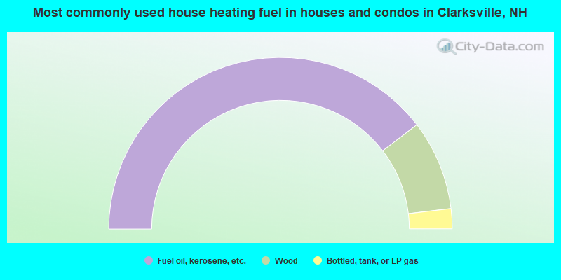
- 79.2%Fuel oil, kerosene, etc.
- 17.0%Wood
- 3.8%Bottled, tank, or LP gas
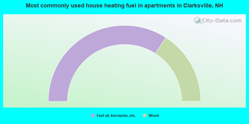
- 68.2%Fuel oil, kerosene, etc.
- 31.8%Wood
Clarksville compared to New Hampshire state average:
- Median house value below state average.
- Unemployed percentage significantly below state average.
- Black race population percentage significantly below state average.
- Hispanic race population percentage significantly below state average.
- Median age significantly above state average.
- Foreign-born population percentage below state average.
- Renting percentage significantly below state average.
- Length of stay since moving in significantly above state average.
- Number of rooms per house significantly below state average.
- House age significantly below state average.
- Percentage of population with a bachelor's degree or higher significantly below state average.