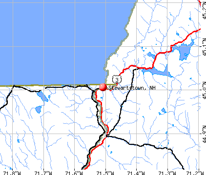
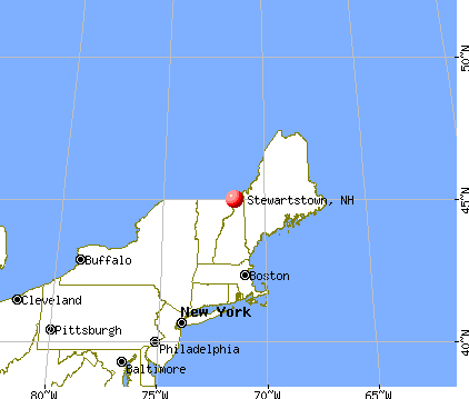
Stewartstown, New Hampshire
Submit your own pictures of this town and show them to the world
- OSM Map
- General Map
- Google Map
- MSN Map
Population change since 2000: -0.8%
 |
| Males: 513 | |
| Females: 491 |
| Median resident age: | 46.2 years |
| New Hampshire median age: | 43.9 years |
Zip codes: 03576.
| Stewartstown: | $50,015 |
| NH: | $89,992 |
Estimated per capita income in 2022: $33,291 (it was $17,231 in 2000)
Stewartstown town income, earnings, and wages data
Estimated median house or condo value in 2022: $168,235 (it was $64,700 in 2000)
| Stewartstown: | $168,235 |
| NH: | $384,700 |
Mean prices in 2022: all housing units: $223,643; detached houses: $241,655; townhouses or other attached units: $431,348; in 2-unit structures: $202,937; in 3-to-4-unit structures: $301,182; in 5-or-more-unit structures: $411,054; mobile homes: $86,091
Detailed information about poverty and poor residents in Stewartstown, NH


- 98297.8%White alone
- 111.1%Hispanic
- 70.7%Two or more races
- 30.3%American Indian alone
- 10.10%Black alone

Races in Stewartstown detailed stats: ancestries, foreign born residents, place of birth
 Recent articles from our blog. Our writers, many of them Ph.D. graduates or candidates, create easy-to-read articles on a wide variety of topics.

 | Zhukovskyy finally going to trial (38 replies) |
| Bought a House near Colebrook. Moving up! (23 replies) |
| Best town in NH for a chest-thumping Libertarian? (30 replies) |
| North to North Central NH (15 replies) |
| Best location for a casino in New Hampshire (19 replies) |
| Looking for somebody Russian-speaking in Bittsburg, NH (2 replies) |
Latest news from Stewartstown, NH collected exclusively by city-data.com from local newspapers, TV, and radio stations
Ancestries: French (28.7%), English (18.5%), United States (13.5%), Irish (12.8%), French Canadian (7.1%), German (4.6%).
Current Local Time: EST time zone
Incorporated in 1795
Elevation: 1140 feet
Land area: 46.4 square miles.
Population density: 22 people per square mile (very low).
77 residents are foreign born (7.1% North America).
| This town: | 7.6% |
| New Hampshire: | 4.4% |
| Stewartstown town: | 1.8% ($1,136) |
| New Hampshire: | 2.3% ($2,946) |
Nearest city with pop. 50,000+: Portland, ME  (107.4 miles , pop. 64,249).
Nearest city with pop. 200,000+: Boston, MA (183.8 miles , pop. 589,141).
Nearest city with pop. 1,000,000+: Bronx, NY (310.0 miles , pop. 1,332,650).
Nearest cities:
), ), Latitude: 44.97 N, Longitude: 71.46 W


| Here: | 4.5% |
| New Hampshire: | 2.5% |


- Furniture & related product manufacturing (30.0%)
- Health care (9.7%)
- Agriculture, forestry, fishing & hunting (8.3%)
- Truck transportation (6.9%)
- Educational services (4.8%)
- Accommodation & food services (3.5%)
- Public administration (3.2%)

- Furniture & related product manufacturing (36.9%)
- Agriculture, forestry, fishing & hunting (14.5%)
- Truck transportation (11.2%)
- Construction (4.8%)
- Educational services (4.8%)
- Motor vehicle & parts dealers (2.4%)
- Plastics & rubber products (2.4%)

- Health care (22.8%)
- Furniture & related product manufacturing (20.7%)
- Personal & laundry services (6.0%)
- Accommodation & food services (6.0%)
- Educational services (4.9%)
- Public administration (4.9%)
- Finance & insurance (4.3%)

- Other production occupations, including supervisors (10.9%)
- Woodworkers (10.6%)
- Driver/sales workers and truck drivers (7.9%)
- Nursing, psychiatric, and home health aides (4.2%)
- Farmers and farm managers (3.9%)
- Other management occupations, except farmers and farm managers (3.9%)
- Laborers and material movers, hand (3.9%)

- Driver/sales workers and truck drivers (13.3%)
- Woodworkers (13.3%)
- Other production occupations, including supervisors (10.0%)
- Farmers and farm managers (6.8%)
- Agricultural workers, including supervisors (6.0%)
- Laborers and material movers, hand (6.0%)
- Other management occupations, except farmers and farm managers (4.8%)

- Other production occupations, including supervisors (12.0%)
- Nursing, psychiatric, and home health aides (9.8%)
- Woodworkers (7.1%)
- Other office and administrative support workers, including supervisors (4.9%)
- Personal appearance workers (4.3%)
- Retail sales workers, except cashiers (4.3%)
- Secretaries and administrative assistants (3.8%)
Average climate in Stewartstown, New Hampshire
Based on data reported by over 4,000 weather stations


Earthquake activity:
Stewartstown-area historical earthquake activity is significantly above New Hampshire state average. It is 78% smaller than the overall U.S. average.On 4/20/2002 at 10:50:47, a magnitude 5.3 (5.3 ML, Depth: 3.0 mi, Class: Moderate, Intensity: VI - VII) earthquake occurred 114.5 miles away from the city center
On 4/20/2002 at 10:50:47, a magnitude 5.2 (5.2 MB, 4.2 MS, 5.2 MW, 5.0 MW) earthquake occurred 116.0 miles away from the city center
On 10/7/1983 at 10:18:46, a magnitude 5.3 (5.1 MB, 5.3 LG, 5.1 ML) earthquake occurred 158.7 miles away from Stewartstown center
On 1/19/1982 at 00:14:42, a magnitude 4.7 (4.5 MB, 4.7 MD, 4.5 LG, Class: Light, Intensity: IV - V) earthquake occurred 101.6 miles away from the city center
On 10/16/2012 at 23:12:25, a magnitude 4.7 (4.7 ML, Depth: 10.0 mi) earthquake occurred 102.6 miles away from Stewartstown center
On 6/16/1995 at 12:13:11, a magnitude 3.8 (3.8 LG, Depth: 3.1 mi, Class: Light, Intensity: II - III) earthquake occurred 52.1 miles away from the city center
Magnitude types: regional Lg-wave magnitude (LG), body-wave magnitude (MB), duration magnitude (MD), local magnitude (ML), surface-wave magnitude (MS), moment magnitude (MW)
Natural disasters:
The number of natural disasters in Coos County (22) is greater than the US average (15).Major Disasters (Presidential) Declared: 11
Emergencies Declared: 9
Causes of natural disasters: Floods: 9, Storms: 9, Hurricanes: 3, Snows: 2, Winter Storms: 2, Blizzard: 1, Ice Storm: 1, Snowfall: 1, Snowstorm: 1, Tropical Storm: 1, Wind: 1, Other: 1 (Note: some incidents may be assigned to more than one category).

Colleges/universities with over 2000 students nearest to Stewartstown:
- University of Maine at Farmington (about 68 miles; Farmington, ME; Full-time enrollment: 2,036)
- Norwich University (about 83 miles; Northfield, VT; FT enrollment: 4,221)
- Plymouth State University (about 85 miles; Plymouth, NH; FT enrollment: 4,838)
- Saint Michael's College (about 90 miles; Colchester, VT; FT enrollment: 2,336)
- Community College of Vermont (about 91 miles; Winooski, VT; FT enrollment: 3,394)
- University of Vermont (about 92 miles; Burlington, VT; FT enrollment: 11,566)
- Saint Joseph's College of Maine (about 93 miles; Standish, ME; FT enrollment: 2,010)
Public elementary/middle school in Stewartstown:
- STEWARTSTOWN COMMUNITY SCHOOL (Students: 89, Location: 60 SCHOOL ST., Grades: KG-8)
Points of interest:
Lakes, reservoirs, and swamps: Diamond Pond (A), Little Diamond Pond (B), Ladd Pond (C), Back Pond (D), Hurlbert Swamp (E), Bear Rock Bog (F). Display/hide their locations on the map
Streams, rivers, and creeks: Cedar Brook (A), Pond Brook (B), Haines Brook (C), Gulch Brook (D), Day Brook (E), Brown Brook (F), Bishop Brook (G). Display/hide their locations on the map
Park in Stewartstown: Coleman State Park (1). Display/hide its location on the map
Birthplace of: Janet C. Long - Politician.
| This town: | 2.3 people |
| New Hampshire: | 2.5 people |
| This town: | 65.9% |
| Whole state: | 66.3% |
| This town: | 12.1% |
| Whole state: | 8.3% |
Likely homosexual households (counted as self-reported same-sex unmarried-partner households)
- Lesbian couples: 0.0% of all households
- Gay men: 1.0% of all households
| This town: | 11.5% |
| Whole state: | 6.5% |
| This town: | 2.8% |
| Whole state: | 2.8% |
People in group quarters in Stewartstown in 2010:
- 72 people in nursing facilities/skilled-nursing facilities
- 31 people in residential treatment centers for juveniles (non-correctional)
- 29 people in local jails and other municipal confinement facilities
People in group quarters in Stewartstown in 2000:
- 77 people in nursing homes
- 33 people in other nonhousehold living situations
- 3 people in religious group quarters
For population 15 years and over in Stewartstown:

- Never married: 28.1%
- Now married: 52.2%
- Separated: 0.9%
- Widowed: 7.7%
- Divorced: 11.2%
For population 25 years and over in Stewartstown:
- High school or higher: 68.5%
- Bachelor's degree or higher: 8.4%
- Graduate or professional degree: 2.7%
- Unemployed: 3.6%
- Mean travel time to work (commute): 13.3 minutes


| Here: | 10.9 |
| New Hampshire average: | 10.9 |
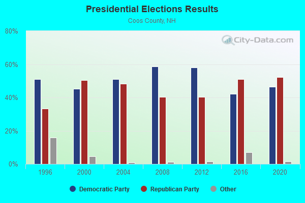
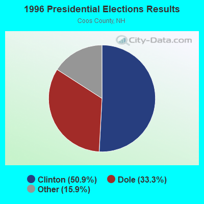
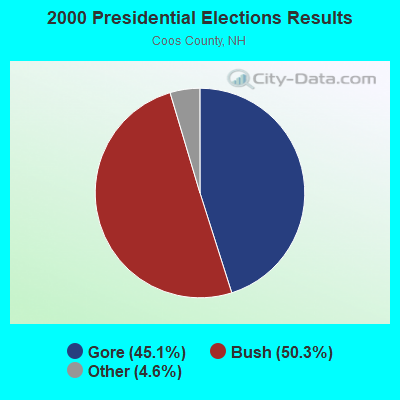
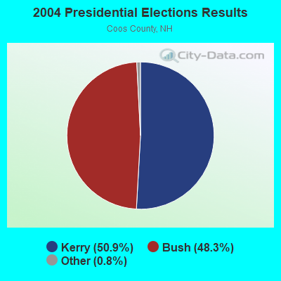
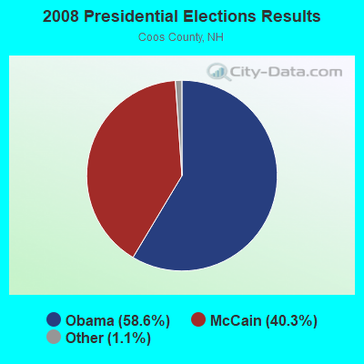
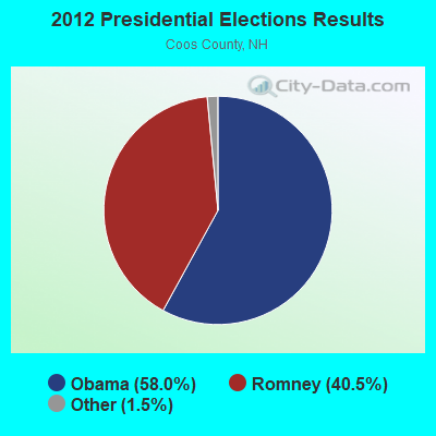


Graphs represent county-level data. Detailed 2008 Election Results
Religion statistics for Stewartstown, NH (based on Coos County data)
| Religion | Adherents | Congregations |
|---|---|---|
| Catholic | 12,710 | 5 |
| Mainline Protestant | 2,105 | 23 |
| Evangelical Protestant | 966 | 14 |
| Other | 323 | 7 |
| Orthodox | 26 | 1 |
| None | 16,925 | - |
Food Environment Statistics:
| Coos County: | 4.33 / 10,000 pop. |
| New Hampshire: | 2.14 / 10,000 pop. |
| This county: | 0.93 / 10,000 pop. |
| New Hampshire: | 1.78 / 10,000 pop. |
| Coos County: | 9.28 / 10,000 pop. |
| State: | 4.02 / 10,000 pop. |
| Coos County: | 12.68 / 10,000 pop. |
| New Hampshire: | 9.70 / 10,000 pop. |
| This county: | 9.7% |
| New Hampshire: | 7.6% |
| This county: | 26.9% |
| State: | 24.4% |
| Coos County: | 9.7% |
| New Hampshire: | 15.9% |
Strongest AM radio stations in Stewartstown:
- WCHP (760 AM; 35 kW; CHAMPLAIN, NY; Owner: CHAMPLAIN RADIO, INC.)
- WTME (780 AM; 10 kW; RUMFORD, ME; Owner: MOUNTAIN VALLEY BROADCASTING, INC.)
- WRKO (680 AM; 50 kW; BOSTON, MA; Owner: ENTERCOM BOSTON LICENSE, LLC)
- WICY (1490 AM; 50 kW; MALONE, NY; Owner: CARTIER COMMUNICATIONS INC.)
- WNNZ (640 AM; 50 kW; WESTFIELD, MA; Owner: CLEAR CHANNEL BROADCASTING LICENSES, INC.)
- WEEI (850 AM; 50 kW; BOSTON, MA; Owner: ENTERCOM BOSTON LICENSE, LLC)
- WCRN (830 AM; 50 kW; WORCESTER, MA; Owner: CARTER BROADCASTING CORPORATION)
- WGY (810 AM; 50 kW; SCHENECTADY, NY; Owner: CLEAR CHANNEL BROADCASTING LICENSES, INC.)
- WDEV (550 AM; 5 kW; WATERBURY, VT; Owner: RADIO VERMONT, INC.)
- WBZ (1030 AM; 50 kW; BOSTON, MA; Owner: INFINITY BROADCASTING OPERATIONS, INC.)
- WKOX (1200 AM; 50 kW; FRAMINGHAM, MA; Owner: CAPSTAR TX LIMITED PARTNERSHIP)
- WALE (990 AM; 50 kW; GREENVILLE, RI; Owner: NORTH AMERICAN BROADCASTING CO., INC.)
- WSKW (1160 AM; 10 kW; SKOWHEGAN, ME; Owner: MOUNTAIN WIRELESS, INCORPORATED)
Strongest FM radio stations in Stewartstown:
- WPKQ (103.7 FM; NORTH CONWAY, NH; Owner: CITADEL BROADCASTING COMPANY)
- WHOM (94.9 FM; MT. WASHINGTON, NH; Owner: CITADEL BROADCASTING COMPANY)
- WGMT (97.7 FM; LYNDON, VT; Owner: VERMONT BROADCAST ASSOCIATES, INC.)
- WTOS-FM (105.1 FM; SKOWHEGAN, ME; Owner: CAPSTAR TX LIMITED PARTNERSHIP)
- WLKC (103.3 FM; WATERBURY, VT; Owner: RADIO BROADCASTING SERVICES, INC.)
- WEZF (92.9 FM; BURLINGTON, VT; Owner: CAPSTAR TX LIMITED PARTNERSHIP)
- WVPS (107.9 FM; BURLINGTON, VT; Owner: VERMONT PUBLIC RADIO)
- WLOB-FM (96.3 FM; RUMFORD, ME; Owner: ATLANTIC COAST RADIO, LLC)
- WMTK (106.3 FM; LITTLETON, NH; Owner: VERMONT BROADCAST ASSOCIATES, INC.)
- WTBM (100.7 FM; MEXICO, ME; Owner: MOUNTAIN VALLEY BROADCASTING, INC.)
- WXXS (102.3 FM; LANCASTER, NH; Owner: BARRY P. LUNDERVILLE)
- WMOO (92.1 FM; DERBY CENTER, VT; Owner: NORTHSTAR MEDIA, INC.)
TV broadcast stations around Stewartstown:
- W18BO (Channel 18; PITTSBURG, NH; Owner: UNIVERSITY OF NEW HAMPSHIRE)
- National Bridge Inventory (NBI) Statistics
- 5Number of bridges
- 43ft / 13.3mTotal length
- $15,710,000Total costs
- 8,226Total average daily traffic
- 364Total average daily truck traffic
- 12,171Total future (year 2042) average daily traffic
FCC Registered Antenna Towers:
8 (See the full list of FCC Registered Antenna Towers in Stewartstown)FCC Registered Broadcast Land Mobile Towers:
2- Holden Hill (Lat: 44.936722 Lon: -71.410361), Type: Pole, Structure height: 24 m, Call Sign: KNBC522,
Assigned Frequencies: 155.595 MHz, Grant Date: 09/14/2021, Expiration Date: 09/16/2031, Registrant: Town Of Lancaster, 25 Main Street, Lancaster, NH 03584, Phone: (603) 788-3221, Fax: (603) 788-3921, Email:
- Mudget Mountain (Lat: 44.963667 Lon: -71.378694), Type: Upole, Structure height: 9 m, Overall height: 14 m, Call Sign: KCC346,
Assigned Frequencies: 47.9000 MHz, 48.9800 MHz, Grant Date: 12/14/2013, Expiration Date: 02/07/2024, Cancellation Date: 01/26/2024, Certifier: Robert Armstrong, Registrant: Nh Electric Cooperative Inc, 579 Tenney Mountain Hwy, Plymouth, NH 03264-3154, Phone: (603) 536-8811, Fax: (603) 536-8686, Email:
FCC Registered Microwave Towers:
2- MUDGET MTN, Mudget Mountain Road (Lat: 44.963667 Lon: -71.378389), Type: Ltower, Structure height: 24.3 m, Call Sign: WQMI788,
Assigned Frequencies: 10875.0 MHz, 6315.84 MHz, 10875.0 MHz, 6315.84 MHz, 10875.0 MHz, 6315.84 MHz, 10875.0 MHz, 6315.84 MHz, 10875.0 MHz, 6315.84 MHz... (+6 more), Grant Date: 07/22/2020, Expiration Date: 08/18/2030, Certifier: Dena Delucca, Registrant: New Hampshire Electric Cooperative, 579 Tenney Mountain Highway, Plymouth, NH 03264, Phone: (603) 536-1800, Email:
- HOLDEN HILL, Diamond Pond Rd (Lat: 44.946833 Lon: -71.340500), Type: Ltower, Structure height: 54.9 m, Call Sign: WQOE726,
Assigned Frequencies: 6375.14 MHz, 6375.14 MHz, 6375.14 MHz, 6375.14 MHz, 6375.14 MHz, 6375.14 MHz, 6375.14 MHz, 6375.14 MHz, Grant Date: 07/01/2021, Expiration Date: 09/01/2031, Certifier: James Kowalik, Registrant: Nh Dept. Of Safety/Emergency Services And Communications, 33 Hazen Dr (Mailing), Concord, NH 03305, Phone: (603) 528-7541, Fax: (603) 271-6629, Email:
FCC Registered Amateur Radio Licenses:
3- Call Sign: KB1FFY, Licensee ID: L00254702, Grant Date: 03/11/2010, Expiration Date: 06/08/2020, Cancellation Date: 06/09/2022, Certifier: Robert J Weir, Registrant: Robert J Weir, 531 Piper Hill Road, Stewartstown, NH 03576
- Call Sign: KB1IWX, Licensee ID: L00583246, Grant Date: 08/30/2022, Expiration Date: 10/17/2032, Certifier: Richard R Duckworth, Registrant: Richard R Duckworth, 735 Hollow Rd, Stewartstown, NH 03576
- Call Sign: KL3LZ, Licensee ID: L01697990, Grant Date: 04/05/2022, Expiration Date: 04/05/2032, Certifier: William P Raymond Jr, Registrant: William P Raymond Jr, 86 Cedar Lane Road, Stewartstown, NH 03576
FAA Registered Aircraft:
1- Aircraft: TAYLORCRAFT BCS12-D (Category: Land, Seats: 2, Weight: Up to 12,499 Pounds, Speed: 78 mph), Engine: CONT MOTOR C85 SERIES (85 HP) (Reciprocating)
N-Number: 43292, N43292, N-43292, Serial Number: 6951, Year manufactured: 1946, Airworthiness Date: 05/25/1953, Certificate Issue Date: 10/15/1996
Registrant (Individual): Douglas L Brooks, 259 Us Route 3, Stewartstown, NH 03576

- 83.2%Fuel oil, kerosene, etc.
- 14.7%Wood
- 1.4%Bottled, tank, or LP gas
- 0.7%Coal or coke

- 84.9%Fuel oil, kerosene, etc.
- 7.0%Electricity
- 5.8%Wood
- 2.3%Utility gas
Stewartstown compared to New Hampshire state average:
- Median household income below state average.
- Median house value significantly below state average.
- Unemployed percentage significantly below state average.
- Black race population percentage significantly below state average.
- Hispanic race population percentage significantly below state average.
- Length of stay since moving in significantly above state average.
- Number of rooms per house significantly below state average.
- House age significantly below state average.
- Institutionalized population percentage significantly above state average.
- Number of college students significantly below state average.
- Percentage of population with a bachelor's degree or higher significantly below state average.
Stewartstown on our top lists:
- #23 on the list of "Top 101 cities with the most residents born in Northern America (population 500+)"
- #23 on the list of "Top 101 cities with the most residents born in Canada (population 500+)"
- #25 on the list of "Top 101 cities with the largest percentage of people in other nonhousehold living situations (population 1,000+)"
- #7 on the list of "Top 101 counties with the highest percentage of residents that smoked 100+ cigarettes in their lives"
- #26 on the list of "Top 101 counties with the highest Ozone (1-hour) air pollution readings in 2012 (ppm)"
- #30 on the list of "Top 101 counties with the lowest percentage of residents that visited a dentist within the past year"
- #69 on the list of "Top 101 counties with the worst general health status score of residents (1-5), 3 years of data"
- #75 on the list of "Top 101 counties with the lowest percentage of residents that exercised in the past month"