District 4, Creagerstown, Maryland
Submit your own pictures of this city and show them to the world
- OSM Map
- General Map
- Google Map
- MSN Map

| Males: 700 | |
| Females: 740 |
| Median resident age: | 41.4 years |
| Maryland median age: | 36.0 years |
Zip code: 21778
| District 4, Creagerstown: | $101,990 |
| MD: | $94,991 |
Estimated per capita income in 2022: $44,864 (it was $21,491 in 2000)
District 4, Creagerstown income, earnings, and wages data
Estimated median house or condo value in 2022: $478,464 (it was $169,900 in 2000)
| District 4, Creagerstown: | $478,464 |
| MD: | $398,100 |
Mean prices in 2022: all housing units: $523,284; detached houses: $575,676; townhouses or other attached units: $390,501; in 2-unit structures: $340,938; in 3-to-4-unit structures: $324,226; in 5-or-more-unit structures: $258,566; mobile homes: $221,205
District 4, Creagerstown, MD residents, houses, and apartments details
Detailed information about poverty and poor residents in District 4, Creagerstown, MD


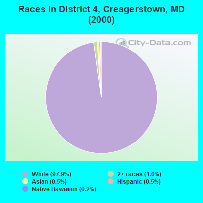
- 1,23197.9%White alone
- 131.0%Two or more races
- 60.5%Asian alone
- 60.5%Hispanic
- 20.2%Native Hawaiian and Other
Pacific Islander alone
Races in District 4, Creagerstown detailed stats: ancestries, foreign born residents, place of birth
 Recent articles from our blog. Our writers, many of them Ph.D. graduates or candidates, create easy-to-read articles on a wide variety of topics.
Current Local Time: EST time zone
Land area: 19.4 square miles.
Population density: 74 people per square mile (very low).

| District 4, Creagerstown: | 0.7% ($1,246) |
| Maryland: | 1.2% ($1,782) |
Nearest city with pop. 50,000+: Frederick, MD  (11.7 miles , pop. 52,767).
Nearest city with pop. 200,000+: Baltimore, MD (43.8 miles , pop. 651,154).
Nearest city with pop. 1,000,000+: Philadelphia, PA (120.7 miles , pop. 1,517,550).
Nearest cities:
), )Latitude: 39.59 N, Longitude: 77.35 W
Area code commonly used in this area: 301

| Here: | 1.9% |
| Maryland: | 2.0% |
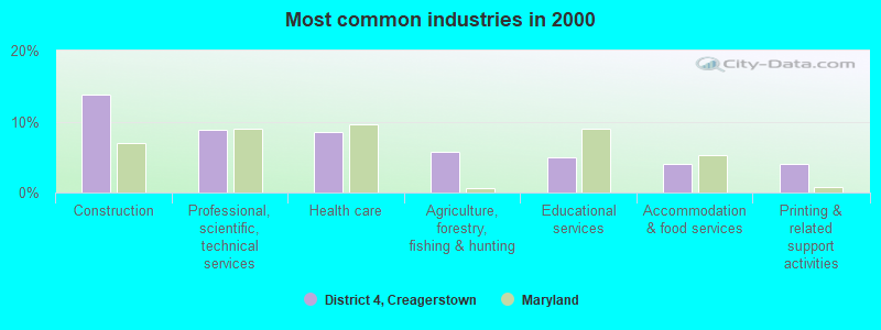
- Construction (13.8%)
- Professional, scientific, technical services (8.9%)
- Health care (8.6%)
- Agriculture, forestry, fishing & hunting (5.7%)
- Educational services (4.9%)
- Accommodation & food services (4.0%)
- Printing & related support activities (4.0%)
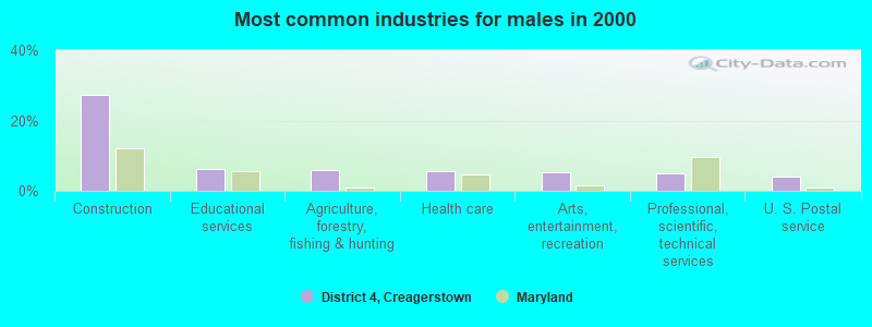
- Construction (27.2%)
- Educational services (6.3%)
- Agriculture, forestry, fishing & hunting (6.0%)
- Health care (5.4%)
- Arts, entertainment, recreation (5.1%)
- Professional, scientific, technical services (4.8%)
- U. S. Postal service (3.9%)
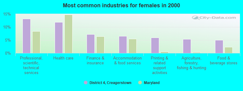
- Professional, scientific, technical services (13.1%)
- Health care (11.8%)
- Finance & insurance (7.2%)
- Accommodation & food services (6.5%)
- Printing & related support activities (5.9%)
- Agriculture, forestry, fishing & hunting (5.3%)
- Food & beverage stores (5.0%)
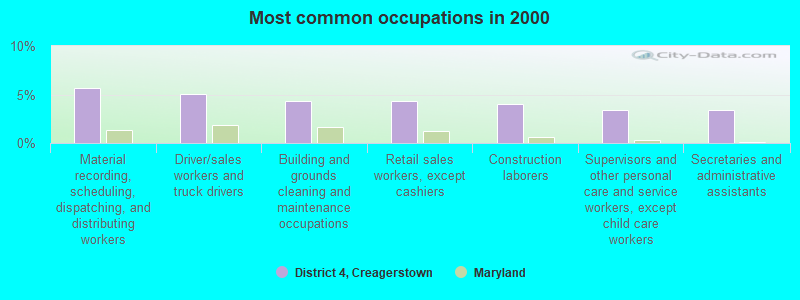
- Material recording, scheduling, dispatching, and distributing workers (5.7%)
- Driver/sales workers and truck drivers (5.1%)
- Building and grounds cleaning and maintenance occupations (4.3%)
- Retail sales workers, except cashiers (4.3%)
- Construction laborers (4.0%)
- Supervisors and other personal care and service workers, except child care workers (3.4%)
- Secretaries and administrative assistants (3.4%)
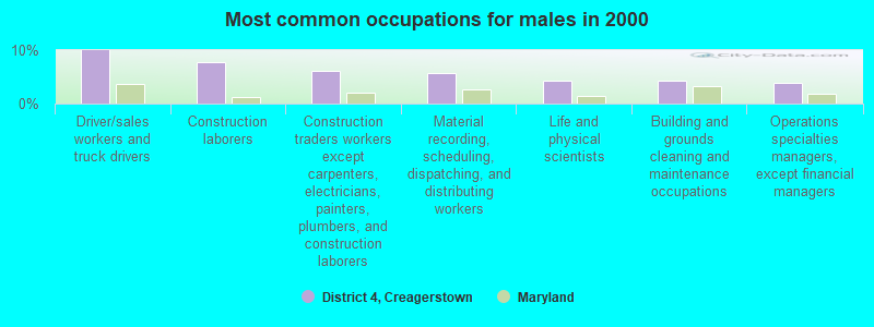
- Driver/sales workers and truck drivers (10.0%)
- Construction laborers (7.9%)
- Construction traders workers except carpenters, electricians, painters, plumbers, and construction laborers (6.0%)
- Material recording, scheduling, dispatching, and distributing workers (5.7%)
- Life and physical scientists (4.2%)
- Building and grounds cleaning and maintenance occupations (4.2%)
- Operations specialties managers, except financial managers (3.9%)

- Secretaries and administrative assistants (6.9%)
- Other office and administrative support workers, including supervisors (5.9%)
- Material recording, scheduling, dispatching, and distributing workers (5.6%)
- Other healthcare support occupations (4.7%)
- Retail sales workers, except cashiers (4.7%)
- Preschool, kindergarten, elementary, and middle school teachers (4.4%)
- Information and record clerks, except customer service representatives (4.4%)
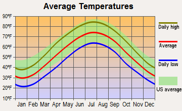
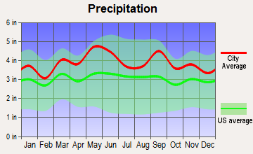
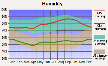
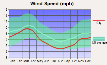
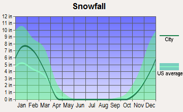
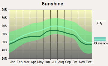
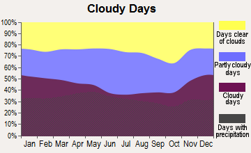
Average climate in District 4, Creagerstown, Maryland
Based on data reported by over 4,000 weather stations
(lower is better)
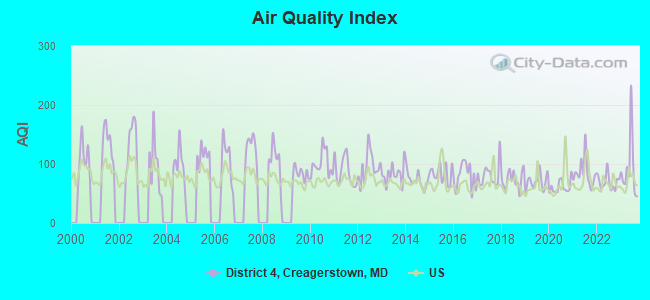
Air Quality Index (AQI) level in 2023 was 91.8. This is worse than average.
| City: | 91.8 |
| U.S.: | 72.6 |
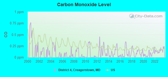
Carbon Monoxide (CO) [ppm] level in 2023 was 0.183. This is better than average. Closest monitor was 20.0 miles away from the city center.
| City: | 0.183 |
| U.S.: | 0.251 |
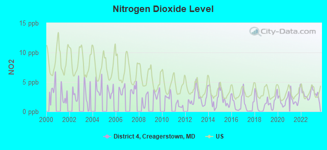
Nitrogen Dioxide (NO2) [ppb] level in 2023 was 2.84. This is significantly better than average. Closest monitor was 3.5 miles away from the city center.
| City: | 2.84 |
| U.S.: | 5.11 |
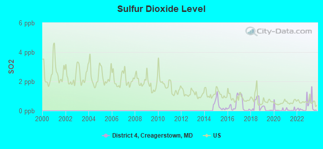
Sulfur Dioxide (SO2) [ppb] level in 2023 was 0.475. This is significantly better than average. Closest monitor was 3.5 miles away from the city center.
| City: | 0.475 |
| U.S.: | 1.515 |
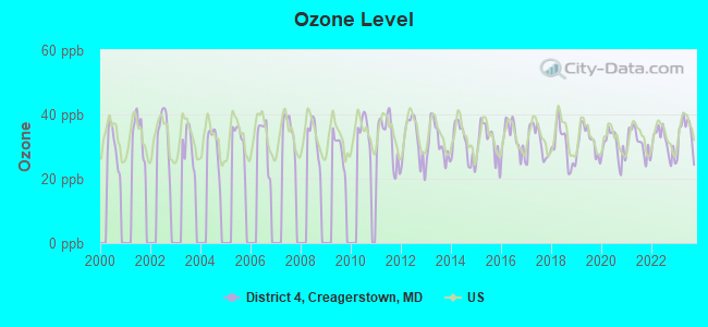
Ozone [ppb] level in 2023 was 34.0. This is about average. Closest monitor was 9.8 miles away from the city center.
| City: | 34.0 |
| U.S.: | 33.3 |
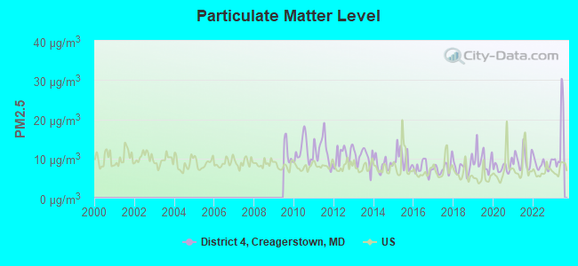
Particulate Matter (PM2.5) [µg/m3] level in 2023 was 14.3. This is significantly worse than average. Closest monitor was 19.7 miles away from the city center.
| City: | 14.3 |
| U.S.: | 8.1 |
Tornado activity:
District 4, Creagerstown-area historical tornado activity is slightly above Maryland state average. It is 6% greater than the overall U.S. average.
On 5/22/1983, a category F3 (max. wind speeds 158-206 mph) tornado 9.5 miles away from the District 4, Creagerstown city center caused between $5000 and $50,000 in damages.
On 7/19/1996, a category F3 tornado 20.7 miles away from the city center injured 3 people and caused $5 million in damages.
Earthquake activity:
District 4, Creagerstown-area historical earthquake activity is significantly above Maryland state average. It is 57% smaller than the overall U.S. average.On 8/23/2011 at 17:51:04, a magnitude 5.8 (5.8 MW, Depth: 3.7 mi, Class: Moderate, Intensity: VI - VII) earthquake occurred 120.3 miles away from the city center
On 9/25/1998 at 19:52:52, a magnitude 5.2 (4.8 MB, 4.3 MS, 5.2 LG, 4.5 MW, Depth: 3.1 mi) earthquake occurred 207.2 miles away from District 4, Creagerstown center
On 1/16/1994 at 01:49:16, a magnitude 4.6 (4.6 MB, 4.6 LG, Depth: 3.1 mi, Class: Light, Intensity: IV - V) earthquake occurred 86.6 miles away from District 4, Creagerstown center
On 8/25/2011 at 05:07:52, a magnitude 4.5 (4.5 ML, Depth: 4.2 mi) earthquake occurred 118.2 miles away from the city center
On 12/9/2003 at 20:59:18, a magnitude 4.5 (4.5 ML, Depth: 6.2 mi) earthquake occurred 131.8 miles away from District 4, Creagerstown center
On 12/9/2003 at 20:59:14, a magnitude 4.5 (4.5 MB, 4.5 LG) earthquake occurred 141.5 miles away from the city center
Magnitude types: regional Lg-wave magnitude (LG), body-wave magnitude (MB), local magnitude (ML), surface-wave magnitude (MS), moment magnitude (MW)
Natural disasters:
The number of natural disasters in Frederick County (21) is greater than the US average (15).Major Disasters (Presidential) Declared: 15
Emergencies Declared: 5
Causes of natural disasters: Floods: 6, Hurricanes: 6, Storms: 5, Winter Storms: 5, Snowstorms: 3, Blizzard: 1, Heavy Rain: 1, Ice Storm: 1, Snowfall: 1, Tornado: 1, Tropical Storm: 1, Other: 1 (Note: some incidents may be assigned to more than one category).
Hospitals and medical centers near District 4, Creagerstown:
- GLADE VALLEY CENTER (Nursing Home, about 8 miles away; WALKERSVILLE, MD)
- ST. VINCENT CARE CENTER (Nursing Home, about 8 miles away; EMMITSBURG, MD)
- ST JOSEPH'S MINISTRIES (Nursing Home, about 8 miles away; EMMITSBURG, MD)
- HOMEWOOD AT CRUMLAND FARMS (Nursing Home, about 9 miles away; FREDERICK, MD)
- FREEDOM HOME DIALYSIS, LLC (Dialysis Facility, about 11 miles away; FREDERICK, MD)
- DAVITA - FREDERICK (Dialysis Facility, about 11 miles away; FREDERICK, MD)
- NORTHAMPTON MANOR (Nursing Home, about 12 miles away; FREDERICK, MD)
Amtrak station near District 4, Creagerstown:
Colleges/universities with over 2000 students nearest to District 4, Creagerstown:
- Mount St Mary's University (about 7 miles; Emmitsburg, MD; Full-time enrollment: 2,313)
- Frederick Community College (about 11 miles; Frederick, MD; FT enrollment: 3,798)
- Hagerstown Community College (about 18 miles; Hagerstown, MD; FT enrollment: 3,220)
- Gettysburg College (about 19 miles; Gettysburg, PA; FT enrollment: 2,772)
- McDaniel College (about 19 miles; Westminster, MD; FT enrollment: 2,558)
- Carroll Community College (about 20 miles; Westminster, MD; FT enrollment: 2,682)
- Shepherd University (about 27 miles; Shepherdstown, WV; FT enrollment: 3,745)
Points of interest:
Notable location: Frederick County Volunteer Fire and Rescue Station 13 Rocky Ridge Volunteer Fire Company (A). Display/hide its location on the map
Churches in District 4, Creagerstown include: Saint Johns Evangelical Lutheran Church (A), Saint Johns Reformed Church (B), Union Bethel Church (C), Monocacy Church of the Brethren (D), Mount Tabor United Church of Christ (E). Display/hide their locations on the map
Cemeteries: Mount Tabor Cemetery (1), Monocacy Cemetery (2), Union Bethel Cemetery (3), Saint Johns Cemetery (4). Display/hide their locations on the map
Streams, rivers, and creeks: Beaver Branch (A), Sandy Run (B), Little Hunting Creek (C), Big Hunting Creek (D), Creagers Ranch (E), Owens Creek (F). Display/hide their locations on the map
Parks in District 4, Creagerstown include: Loys Station Park (1), Creagerstown Park (2), Rocky Ridge Park (3). Display/hide their locations on the map
| This city: | 2.6 people |
| Maryland: | 2.6 people |
| This city: | 74.3% |
| Whole state: | 67.1% |
| This city: | 8.1% |
| Whole state: | 6.4% |
Likely homosexual households (counted as self-reported same-sex unmarried-partner households)
- Lesbian couples: 1.5% of all households
- Gay men: 0.0% of all households
| This city: | 6.4% |
| Whole state: | 8.5% |
| This city: | 3.1% |
| Whole state: | 4.2% |
For population 15 years and over in District 4, Creagerstown:
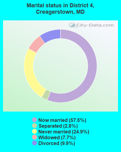
- Never married: 24.9%
- Now married: 57.5%
- Separated: 2.8%
- Widowed: 7.7%
- Divorced: 9.9%
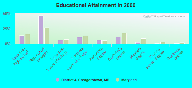
For population 25 years and over in District 4, Creagerstown:
- High school or higher: 86.4%
- Bachelor's degree or higher: 15.3%
- Graduate or professional degree: 3.9%
- Unemployed: 2.5%
- Mean travel time to work (commute): 29.6 minutes
| Here: | 9.5 |
| Maryland average: | 12.7 |
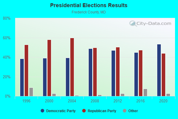
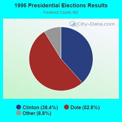
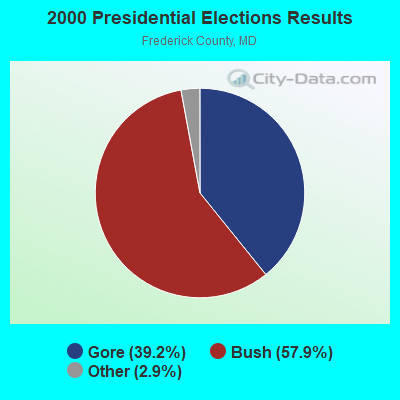
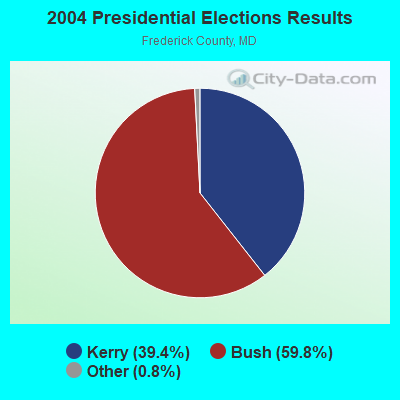
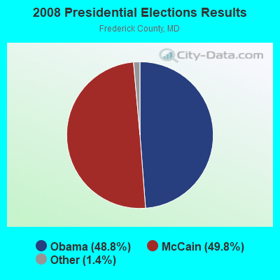
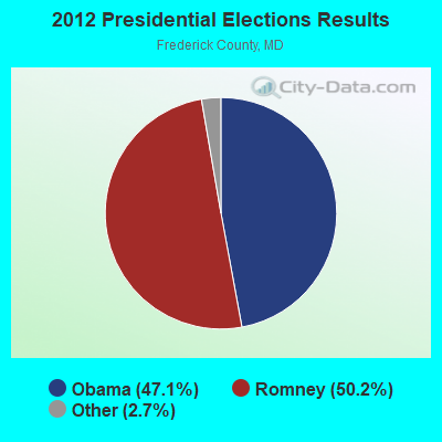
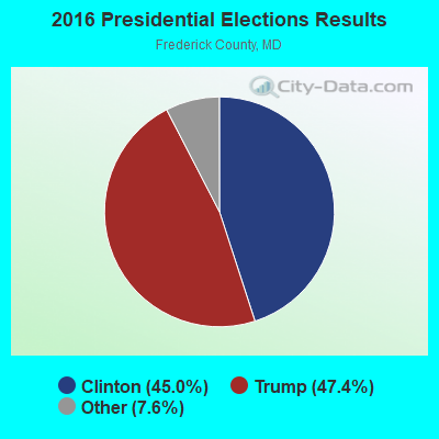
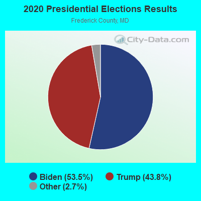
Graphs represent county-level data. Detailed 2008 Election Results
Religion statistics for District 4, Creagerstown, MD (based on Frederick County data)
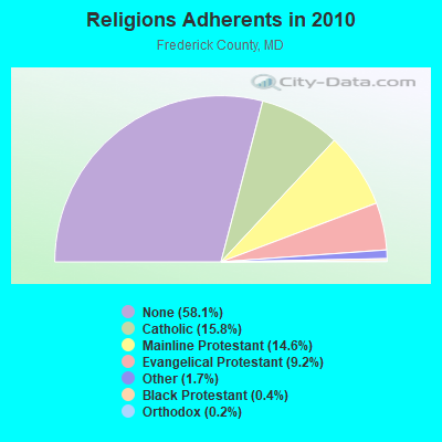
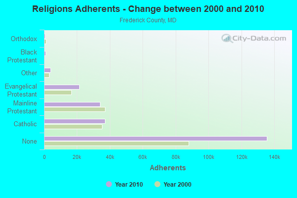
| Religion | Adherents | Congregations |
|---|---|---|
| Catholic | 36,923 | 12 |
| Mainline Protestant | 34,107 | 110 |
| Evangelical Protestant | 21,401 | 113 |
| Other | 3,901 | 19 |
| Black Protestant | 931 | 5 |
| Orthodox | 545 | 2 |
| None | 135,577 | - |
Food Environment Statistics:
| This county: | 1.65 / 10,000 pop. |
| State: | 1.96 / 10,000 pop. |
| Frederick County: | 0.09 / 10,000 pop. |
| Maryland: | 0.07 / 10,000 pop. |
| Frederick County: | 0.94 / 10,000 pop. |
| Maryland: | 1.22 / 10,000 pop. |
| This county: | 2.14 / 10,000 pop. |
| Maryland: | 2.05 / 10,000 pop. |
| Frederick County: | 5.62 / 10,000 pop. |
| Maryland: | 5.40 / 10,000 pop. |
| Frederick County: | 7.8% |
| State: | 9.1% |
| Frederick County: | 26.4% |
| State: | 26.7% |
| Frederick County: | 17.5% |
| Maryland: | 15.5% |
8.94% of this county's 2021 resident taxpayers lived in other counties in 2020 ($83,001 average adjusted gross income)
| Here: | 8.94% |
| Maryland average: | 7.42% |
0.06% of residents moved from foreign countries ($513 average AGI)
Frederick County: 0.06% Maryland average: 0.05%
Top counties from which taxpayers relocated into this county between 2020 and 2021:
| from Montgomery County, MD | |
| from Howard County, MD | |
| from Washington County, MD |
7.01% of this county's 2020 resident taxpayers moved to other counties in 2021 ($77,350 average adjusted gross income)
| Here: | 7.01% |
| Maryland average: | 7.91% |
0.03% of residents moved to foreign countries ($420 average AGI)
Frederick County: 0.03% Maryland average: 0.04%
Top counties to which taxpayers relocated from this county between 2020 and 2021:
| to Washington County, MD | |
| to Montgomery County, MD | |
| to Carroll County, MD |
Strongest AM radio stations in District 4, Creagerstown:
- WCBM (680 AM; 50 kW; BALTIMORE, MD; Owner: WCBM MARYLAND, INC.)
- WMET (1150 AM; 50 kW; GAITHERSBURG, MD; Owner: BELTWAY ACQUISITION CORPORATION)
- WBAL (1090 AM; 50 kW; BALTIMORE, MD; Owner: HEARST RADIO, INC.)
- WGOP (700 AM; daytime; 25 kW; WALKERSVILLE, MD; Owner: BIRACH BROADCASTING CORPORATION)
- WFMD (930 AM; 5 kW; FREDERICK, MD; Owner: CAPSTAR TX LIMITED PARTNERSHIP)
- WXTR (820 AM; 4 kW; FREDERICK, MD; Owner: BONNEVILLE HOLDING COMPANY)
- WTHU (1450 AM; 0 kW; THURMONT, MD; Owner: CHARLES R. WALMER)
- WTEM (980 AM; 50 kW; WASHINGTON, DC; Owner: AMFM RADIO LICENSES, L.L.C.)
- WTRI (1520 AM; daytime; 17 kW; BRUNSWICK, MD; Owner: JMK COMMUNICATIONS, INC.)
- WTOP (1500 AM; 50 kW; WASHINGTON, DC; Owner: BONNEVILLE HOLDING COMPANY)
- WWLG (1370 AM; 50 kW; BALTIMORE, MD; Owner: M-10 BROADCASTING, INC.)
- WPGC (1580 AM; 50 kW; MORNINGSIDE, MD; Owner: INFINITY WPGC(AM), INC.)
- WBIS (1190 AM; 50 kW; ANNAPOLIS, MD; Owner: NATIONS RADIO, LLC)
Strongest FM radio stations in District 4, Creagerstown:
- WFRE (99.9 FM; FREDERICK, MD; Owner: CAPSTAR TX LIMITED PARTNERSHIP)
- WAYZ-FM (104.7 FM; HAGERSTOWN, MD; Owner: HJV LIMITED PARTNERSHIP)
- WETH (89.1 FM; HAGERSTOWN, MD; Owner: GREATER WASHINGTON EDUCATIONAL TELECOMMUNICATIONS ASSN.)
- W219BX (91.7 FM; FREDERICK, MD; Owner: CEDAR RIDGE CHILDREN'S HOME & SCHOOL, INC)
- WWVZ (103.9 FM; BRADDOCK HEIGHTS, MD; Owner: BONNEVILLE HOLDING COMPANY)
- W219BE (91.7 FM; WAYNESBORO, PA; Owner: MARANATHA BIBLE INSTITUTE, NDBA)
- WARX (106.9 FM; HAGERSTOWN, MD; Owner: MANNING BROADCASTING INC.)
- WAFY (103.1 FM; MIDDLETOWN, MD; Owner: FREDERICK BROADCASTING LLC)
- WMTB-FM (89.9 FM; EMMITSBURG, MD; Owner: MOUNT SAINT MARY'S COLLEGE, INCORPORATED)
- WEEO-FM (103.7 FM; MCCONNELLSBURG, PA; Owner: ALLEGHENY MOUNTAIN NETWORK)
- WYCR (98.5 FM; YORK-HANOVER, PA; Owner: RADIO HANOVER, INC.)
- WGTY (107.7 FM; GETTYSBURG, PA; Owner: TIMES AND NEWS PUBLISHING COMPANY)
- WWMX (106.5 FM; BALTIMORE, MD; Owner: INFINITY RADIO OPERATIONS INC.)
- WZBA (100.7 FM; WESTMINSTER, MD; Owner: SHAMROCK COMMUNICATIONS, INC.)
- WCRH (90.5 FM; WILLIAMSPORT, MD; Owner: CEDAR RIDGE CHILDREN'S HOME & SCHOOL, INC)
- WLTF (97.5 FM; MARTINSBURG, WV; Owner: PRETTYMAN BROADCASTING COMPANY)
- WZBT (91.1 FM; GETTYSBURG, PA; Owner: GETTYSBURG COLLEGE)
- W228BA (93.5 FM; LEESBURG, VA; Owner: CSN INTERNATIONAL)
- WROZ (101.3 FM; LANCASTER, PA; Owner: HALL COMMUNICATIONS, INC.)
- WARM-FM (103.3 FM; YORK, PA; Owner: WSBA LICO, INC.)
TV broadcast stations around District 4, Creagerstown:
- WMPB (Channel 67; BALTIMORE, MD; Owner: MARYLAND PUBLIC BROADCASTING COMMISSION)
- WBAL-TV (Channel 11; BALTIMORE, MD; Owner: WBAL HEARST-ARGYLE TV, INC. (CA CORP.))
- WMAR-TV (Channel 2; BALTIMORE, MD; Owner: SCRIPPS HOWARD BROADCASTING COMPANY)
- WBFF (Channel 45; BALTIMORE, MD; Owner: CHESAPEAKE TELEVISION LICENSEE, LLC)
- WFPT (Channel 62; FREDERICK, MD; Owner: MARYLAND PUBLIC BROADCASTING COMMISSION)
- WNUV (Channel 54; BALTIMORE, MD; Owner: BALTIMORE (WNUV-TV) LICENSEE, INC.)
- W52AS (Channel 52; FREDERICK, MD; Owner: THREE ANGELS BROADCASTING NETWORK)
- WUTB (Channel 24; BALTIMORE, MD; Owner: FOX TELEVISION STATIONS, INC.)
- WJZ-TV (Channel 13; BALTIMORE, MD; Owner: VIACOM INC.)
- W42CK (Channel 42; HAGERSTOWN, MD; Owner: THREE ANGELS BROADCASTING)
- W51CY (Channel 51; CHAMBERSBURG, PA; Owner: WBDC BROADCASTING, INC.)
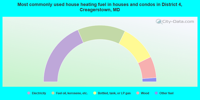
- 37.2%Electricity
- 27.5%Fuel oil, kerosene, etc.
- 20.9%Bottled, tank, or LP gas
- 12.2%Wood
- 2.3%Other fuel
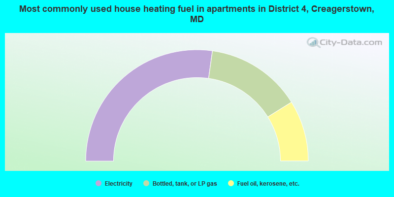
- 54.4%Electricity
- 27.8%Bottled, tank, or LP gas
- 17.7%Fuel oil, kerosene, etc.
District 4, Creagerstown compared to Maryland state average:
- Unemployed percentage significantly below state average.
- Black race population percentage significantly below state average.
- Hispanic race population percentage significantly below state average.
- Median age above state average.
- Foreign-born population percentage significantly below state average.
- Renting percentage below state average.
- Length of stay since moving in significantly above state average.
- Number of rooms per house significantly below state average.
- House age significantly below state average.
- Percentage of population with a bachelor's degree or higher below state average.