Chualar, California
Submit your own pictures of this place and show them to the world
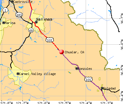
- OSM Map
- General Map
- Google Map
- MSN Map
Population change since 2000: -17.6%
| Males: 645 | |
| Females: 545 |
| Median resident age: | 32.0 years |
| California median age: | 37.9 years |
| Chualar: | |
| CA: |
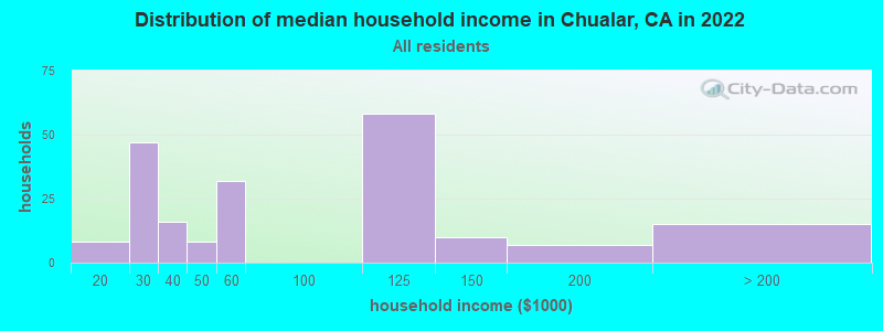
Estimated per capita income in 2022: $18,575 (it was $10,096 in 2000)
Chualar CDP income, earnings, and wages data
Estimated median house or condo value in 2022: $646,683 (it was $154,200 in 2000)
| Chualar: | $646,683 |
| CA: | $715,900 |
Mean prices in 2022: all housing units: $634,913; detached houses: $640,466
Median gross rent in 2022: $1,338.
Detailed information about poverty and poor residents in Chualar, CA
Compare current foreclosures near Chualar, CA:
| Photo | Address | Area | Beds / Baths | Price | Details |
|---|---|---|---|---|---|

|
#1
Arezzo Cir
Salinas, CA 93905
|
2,131 sq. feet
|
2 baths 5 beds |
show details | |

|
#2
Little River Dr
Salinas, CA 93906
|
2,405 sq. feet
|
2 baths 4 beds |
show details | |

|
#3
Main St
Soledad, CA 93960
|
1,542 sq. feet
|
2 baths 3 beds |
show details | |

|
#4
W Alisal St
Salinas, CA 93901
|
2,122 sq. feet
|
1 baths 3 beds |
show details | |

|
#5
La Mesa Dr
Salinas, CA 93901
|
1,456 sq. feet
|
2 baths 3 beds |
show details | |

|
#6
Legends Ct
Salinas, CA 93908
|
3,821 sq. feet
|
4 baths 5 beds |
show details | |

|
#7
3rd St
Soledad, CA 93960
|
1,165 sq. feet
|
2 baths 4 beds |
show details | |

|
#8
Fulton Way
Salinas, CA 93907
|
1,248 sq. feet
|
2 baths 3 beds |
show details | |

|
#9
Alameda Ave
Salinas, CA 93901
|
1,720 sq. feet
|
2 baths 3 beds |
show details | |

|
#10
Belavida Rd
Monterey, CA 93940
|
5,790 sq. feet
|
5 baths 5 beds |
show details |
| Photo | Address | Area | Beds / Baths | Price | Details |
|---|---|---|---|---|---|

|
#11
Amarillo Way
Salinas, CA 93905
|
1,065 sq. feet
|
2 baths 3 beds |
show details | |

|
#12
Alvarado Ct
Salinas, CA 93907
|
1,170 sq. feet
|
2 baths 3 beds |
show details | |

|
#13
Oxford Ct
Salinas, CA 93906
|
3,175 sq. feet
|
3 baths 6 beds |
show details | |

|
#14
Arcadia Ct
Salinas, CA 93906
|
2,473 sq. feet
|
3 baths 4 beds |
show details | |

|
#15
Los Olivos Dr Unit 20
Salinas, CA 93901
|
1,275 sq. feet
|
1 baths 2 beds |
show details | |

|
#16
Cascade Way
Salinas, CA 93906
|
2,922 sq. feet
|
3 baths 4 beds |
show details | |

|
#17
Noice Dr
Salinas, CA 93906
|
1,180 sq. feet
|
1 baths 2 beds |
show details | |

|
#18
Baywood Pl
Salinas, CA 93901
|
1,674 sq. feet
|
2 baths 2 beds |
show details | |

|
#19
Lemos Ave
Salinas, CA 93901
|
1,542 sq. feet
|
2 baths 3 beds |
show details | |

|
#20
Colton Dr
Salinas, CA 93907
|
1,194 sq. feet
|
2 baths 3 beds |
show details |
| Photo | Address | Area | Beds / Baths | Price | Details |
|---|---|---|---|---|---|

|
#21
Coleridge Dr
Salinas, CA 93901
|
2,190 sq. feet
|
2 baths 3 beds |
show details | |

|
#22
Woodside Dr Unit 110
Salinas, CA 93901
|
1,773 sq. feet
|
2 baths 3 beds |
show details | |

|
#23
Boston St
Salinas, CA 93906
|
2,071 sq. feet
|
2 baths 4 beds |
show details | |

|
#24
Chaucer Dr
Salinas, CA 93901
|
1,360 sq. feet
|
2 baths 3 beds |
show details | |

|
#25
Sherman Cir
Salinas, CA 93907
|
1,170 sq. feet
|
2 baths 3 beds |
show details | |

|
#26
Chardonnay Dr
Salinas, CA 93906
|
1,374 sq. feet
|
1 baths 3 beds |
show details | |

|
#27
Boeing Ave
Salinas, CA 93906
|
1,613 sq. feet
|
1 baths 3 beds |
show details | |

|
#28
Harper Canyon Rd
Salinas, CA 93908
|
1,901 sq. feet
|
2 baths 3 beds |
show details | |

|
#29
Monroe St
Salinas, CA 93906
|
961 sq. feet
|
1 baths 2 beds |
show details | |

|
#30
Douglas Ave
Salinas, CA 93906
|
1,080 sq. feet
|
1 baths 2 beds |
show details |
| Photo | Address | Area | Beds / Baths | Price | Details |
|---|---|---|---|---|---|

|
#31
Portola Dr
Salinas, CA 93908
|
1,748 sq. feet
|
2 baths 3 beds |
show details | |

|
#32
Chestnut St
Salinas, CA 93901
|
1,913 sq. feet
|
2 baths 2 beds |
show details | |

|
#33
Oak St
Salinas, CA 93901
|
1,392 sq. feet
|
1 baths 3 beds |
show details | |

|
#34
Crescent Way
Salinas, CA 93906
|
1,320 sq. feet
|
1 baths 2 beds |
show details | |

|
#35
Tyler St
Salinas, CA 93906
|
1,566 sq. feet
|
2 baths 3 beds |
show details | |

|
#36
Linwood Dr
Salinas, CA 93906
|
1,232 sq. feet
|
2 baths 3 beds |
show details | |

|
#37
Yosemite Cir
Salinas, CA 93906
|
1,160 sq. feet
|
2 baths 3 beds |
show details | |

|
#38
Los Altos Way
Salinas, CA 93906
|
1,440 sq. feet
|
2 baths 3 beds |
show details | |

|
#39
Vallejo St
Salinas, CA 93906
|
1,215 sq. feet
|
2 baths 4 beds |
show details | |

|
#40
Cabrillo Ave
Salinas, CA 93906
|
1,325 sq. feet
|
1 baths 4 beds |
show details |
| Photo | Address | Area | Beds / Baths | Price | Details |
|---|---|---|---|---|---|

|
#41
W Alisal St
Salinas, CA 93901
|
1,525 sq. feet
|
2 baths 3 beds |
show details | |

|
#42
Vincent Pl
Salinas, CA 93907
|
1,723 sq. feet
|
3 baths 4 beds |
show details | |

|
#43
Greenwich Way
Salinas, CA 93907
|
1,831 sq. feet
|
2 baths 3 beds |
show details | |

|
#44
Los Altos Way
Salinas, CA 93906
|
1,742 sq. feet
|
2 baths 4 beds |
show details | |

|
#45
San Simeon Dr
Salinas, CA 93901
|
1,520 sq. feet
|
2 baths 4 beds |
show details | |

|
#46
Greenbriar Way
Salinas, CA 93907
|
1,624 sq. feet
|
2 baths 3 beds |
show details | |

|
#47
Donner Way
Salinas, CA 93906
|
1,360 sq. feet
|
2 baths 3 beds |
show details | |

|
#48
Rico St
Salinas, CA 93907
|
1,478 sq. feet
|
2 baths 3 beds |
show details | |

|
#49
Preston St
Salinas, CA 93901
|
1,060 sq. feet
|
2 baths 3 beds |
show details | |

|
Check over 1 million property listings on Foreclosure.com!
|
browse all offers | |||


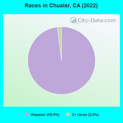
- 94699.8%Hispanic
- 192.0%Two or more races
According to our research of California and other state lists, there were 3 registered sex offenders living in Chualar, California as of May 02, 2024.
The ratio of all residents to sex offenders in Chualar is 417 to 1.
 Recent articles from our blog. Our writers, many of them Ph.D. graduates or candidates, create easy-to-read articles on a wide variety of topics.

 | Monterey County/Salinas/Monterey Places to Live (14 replies) |
Latest news from Chualar, CA collected exclusively by city-data.com from local newspapers, TV, and radio stations
Current Local Time: PST time zone
Elevation: 105 feet
Land area: 0.60 square miles.
Population density: 1,972 people per square mile (low).
380 residents are foreign born (39.6% Latin America).
| This place: | 40.0% |
| California: | 26.5% |
| Chualar CDP: | 1.0% ($1,535) |
| California: | 0.8% ($1,564) |
Nearest city with pop. 50,000+: Salinas, CA  (10.6 miles , pop. 151,060).
Nearest city with pop. 200,000+: San Jose, CA (54.5 miles , pop. 894,943).
Nearest city with pop. 1,000,000+: Los Angeles, CA (246.8 miles , pop. 3,694,820).
Nearest cities:
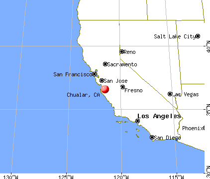
), ), ), ), ), Latitude: 36.57 N, Longitude: 121.52 W
Area code: 831
Property values in Chualar, CA

| Here: | 8.6% |
| California: | 5.1% |
- Agriculture, forestry, fishing & hunting (33.1%)
- Groceries & related products merchant wholesalers (9.0%)
- Educational services (6.7%)
- Health care (5.0%)
- Administrative & support & waste management services (4.0%)
- Construction (3.3%)
- Truck transportation (3.3%)

- Agriculture, forestry, fishing & hunting (34.0%)
- Groceries & related products merchant wholesalers (7.0%)
- Construction (5.3%)
- Truck transportation (5.3%)
- Repair & maintenance (5.0%)
- Educational services (5.0%)
- Administrative & support & waste management services (4.3%)
- Agriculture, forestry, fishing & hunting (31.5%)
- Groceries & related products merchant wholesalers (12.4%)
- Educational services (9.6%)
- Health care (7.3%)
- Food (6.7%)
- Public administration (5.1%)
- Social assistance (4.5%)

- Agricultural workers, including supervisors (35.1%)
- Laborers and material movers, hand (6.5%)
- Building and grounds cleaning and maintenance occupations (6.1%)
- Driver/sales workers and truck drivers (4.6%)
- Vehicle and mobile equipment mechanics, installers, and repairers (4.2%)
- Construction traders workers except carpenters, electricians, painters, plumbers, and construction laborers (3.3%)
- Child care workers (3.3%)
- Agricultural workers, including supervisors (31.0%)
- Laborers and material movers, hand (8.3%)
- Building and grounds cleaning and maintenance occupations (8.0%)
- Driver/sales workers and truck drivers (6.7%)
- Vehicle and mobile equipment mechanics, installers, and repairers (6.7%)
- Construction traders workers except carpenters, electricians, painters, plumbers, and construction laborers (5.3%)
- Other material moving workers, except laborers (2.7%)
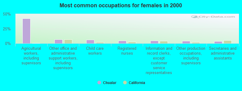
- Agricultural workers, including supervisors (42.1%)
- Other office and administrative support workers, including supervisors (6.7%)
- Child care workers (6.2%)
- Registered nurses (4.5%)
- Information and record clerks, except customer service representatives (4.5%)
- Other production occupations, including supervisors (3.9%)
- Secretaries and administrative assistants (3.4%)
Average climate in Chualar, California
Based on data reported by over 4,000 weather stations


|
|


(lower is better)
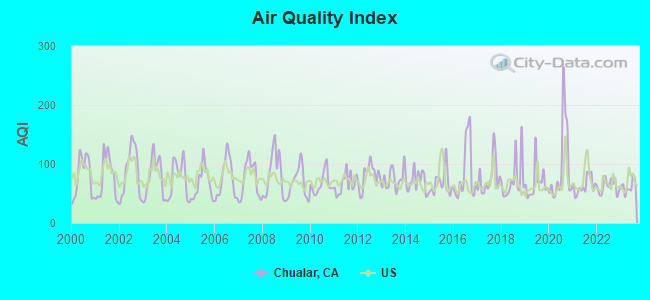
Air Quality Index (AQI) level in 2023 was 61.8. This is about average.
| City: | 61.8 |
| U.S.: | 72.6 |
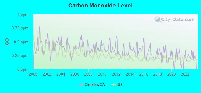
Carbon Monoxide (CO) [ppm] level in 2023 was 0.228. This is about average. Closest monitor was 10.2 miles away from the city center.
| City: | 0.228 |
| U.S.: | 0.251 |
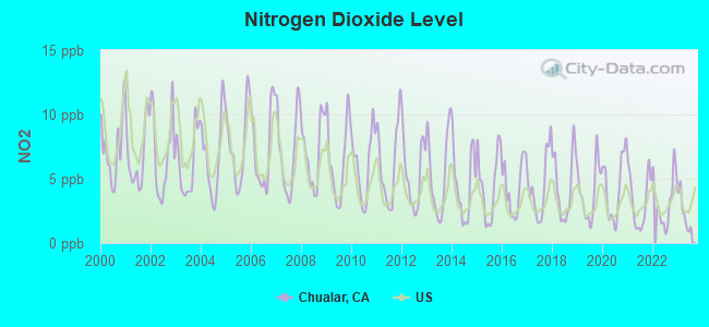
Nitrogen Dioxide (NO2) [ppb] level in 2023 was 2.40. This is significantly better than average. Closest monitor was 10.2 miles away from the city center.
| City: | 2.40 |
| U.S.: | 5.11 |
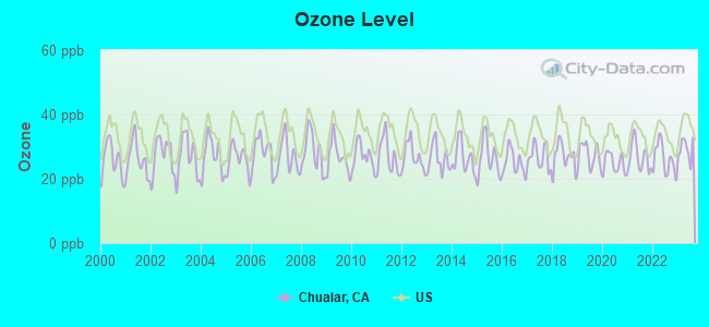
Ozone [ppb] level in 2023 was 29.1. This is about average. Closest monitor was 5.8 miles away from the city center.
| City: | 29.1 |
| U.S.: | 33.3 |
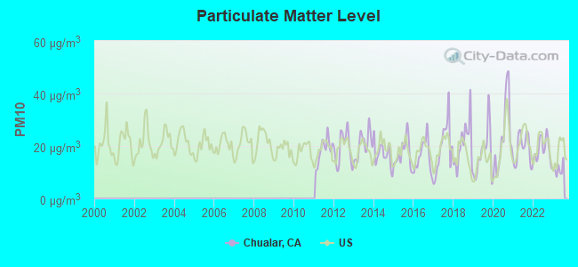
Particulate Matter (PM10) [µg/m3] level in 2023 was 11.1. This is significantly better than average. Closest monitor was 10.5 miles away from the city center.
| City: | 11.1 |
| U.S.: | 19.2 |
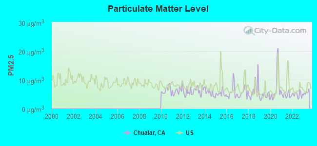
Particulate Matter (PM2.5) [µg/m3] level in 2023 was 5.57. This is significantly better than average. Closest monitor was 10.5 miles away from the city center.
| City: | 5.57 |
| U.S.: | 8.11 |
Earthquake activity:
Chualar-area historical earthquake activity is significantly above California state average. It is 7671% greater than the overall U.S. average.On 4/18/1906 at 13:12:21, a magnitude 7.9 (7.9 UK, Class: Major, Intensity: VIII - XII) earthquake occurred 128.3 miles away from the city center, causing $524,000,000 total damage
On 11/4/1927 at 13:51:53, a magnitude 7.5 (7.5 UK) earthquake occurred 117.7 miles away from Chualar center
On 7/21/1952 at 11:52:14, a magnitude 7.7 (7.7 UK) earthquake occurred 178.1 miles away from Chualar center, causing $50,000,000 total damage
On 10/18/1989 at 00:04:15, a magnitude 7.1 (6.5 MB, 7.1 MS, 6.9 MW, 7.0 ML) earthquake occurred 39.9 miles away from the city center, causing 62 deaths (62 shaking deaths) and 3757 injuries, causing $1,305,032,704 total damage
On 5/2/1983 at 23:42:37, a magnitude 6.7 (6.2 MB, 6.5 MS, 6.5 MW, 6.7 ML, Class: Strong, Intensity: VII - IX) earthquake occurred 71.7 miles away from the city center, causing $31,000,000 total damage
On 12/22/2003 at 19:15:56, a magnitude 6.6 (6.1 MB, 6.4 MS, 6.6 MW, 6.4 MW) earthquake occurred 70.3 miles away from Chualar center, causing 2 deaths (2 shaking deaths) and 40 injuries, causing $200,000,000 total damage
Magnitude types: body-wave magnitude (MB), local magnitude (ML), surface-wave magnitude (MS), moment magnitude (MW)
Natural disasters:
The number of natural disasters in Monterey County (23) is greater than the US average (15).Major Disasters (Presidential) Declared: 14
Emergencies Declared: 3
Causes of natural disasters: Floods: 12, Winter Storms: 7, Storms: 6, Fires: 4, Landslides: 4, Mudslides: 4, Freezes: 2, Drought: 1, Earthquake: 1, Hurricane: 1, Tornado: 1, Tsunami Wave: 1, Other: 1 (Note: some incidents may be assigned to more than one category).
Hospitals and medical centers near Chualar:
- SALINAS DIALYSIS CENTER (Dialysis Facility, about 9 miles away; SALINAS, CA)
- KINDRED NURSING AND TRANSITIONAL CARE-PACIFIC COAS (Nursing Home, about 10 miles away; SALINAS, CA)
- WINDSOR GARDENS REHABILITATION CENTER OF SALINAS (Nursing Home, about 10 miles away; SALINAS, CA)
- SALINAS VALLEY MEMORIAL HOSPITAL Acute Care Hospitals (about 10 miles away; SALINAS, CA)
- KATHERINE HEALTHCARE (Nursing Home, about 10 miles away; SALINAS, CA)
- COMMUNITY HOSPITAL OF SALINAS (Hospital, about 10 miles away; SALINAS, CA)
- VNA INTERMITTENT CARE, INC (Home Health Center, about 10 miles away; SALINAS, CA)
Amtrak stations near Chualar:
- 11 miles: SALINAS (11 STATION PLACE) . Services: ticket office, partially wheelchair accessible, enclosed waiting area, public restrooms, public payphones, vending machines, free short-term parking, free long-term parking, call for car rental service, call for taxi service, public transit connection.
- 15 miles: SOLEDAD (1000 FRONT ST.) - Bus Station . Services: fully wheelchair accessible, public restrooms, public payphones, snack bar, free short-term parking.
- 19 miles: SEASIDE (BLDG. T-1176, 4TH ST.) - Bus Station . Services: fully wheelchair accessible, public payphones, free short-term parking, call for taxi service, public transit connection.
Colleges/universities with over 2000 students nearest to Chualar:
- Hartnell College (about 12 miles; Salinas, CA; Full-time enrollment: 5,506)
- California State University-Monterey Bay (about 17 miles; Seaside, CA; FT enrollment: 5,125)
- Naval Postgraduate School (about 21 miles; Monterey, CA; FT enrollment: 4,951)
- Monterey Peninsula College (about 21 miles; Monterey, CA; FT enrollment: 4,588)
- Gavilan College (about 29 miles; Gilroy, CA; FT enrollment: 3,327)
- Cabrillo College (about 37 miles; Aptos, CA; FT enrollment: 7,729)
- University of California-Santa Cruz (about 43 miles; Santa Cruz, CA; FT enrollment: 17,751)
Public elementary/middle school in Chualar:
- CHUALAR ELEMENTARY (Students: 247, Location: 24285 LINCOLN ST., Grades: KG-8)
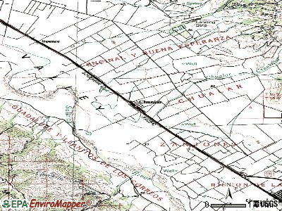
Points of interest:
Notable location: Salinas Rural Fire Protection District Station 2 Chualar Station (A). Display/hide its location on the map
Drinking water stations with addresses in Chualar and their reported violations in the past:
CONUNDRUM WINERY WS (Population served: 25, Groundwater):Past health violations:
- MCL, Monthly (TCR) - Between JUL-2008 and SEP-2008, Contaminant: Coliform. Follow-up actions: St Violation/Reminder Notice (OCT-31-2008), St Public Notif requested (OCT-31-2008)
- MCL, Monthly (TCR) - Between JUL-2008 and SEP-2008, Contaminant: Coliform. Follow-up actions: St Violation/Reminder Notice (OCT-31-2008), St Public Notif requested (OCT-31-2008)
Drinking water stations with addresses in Chualar that have no violations reported:
- CHUALAR CYN WS #11 (Population served: 48, Primary Water Source Type: Groundwater)
| This place: | 4.9 people |
| California: | 2.9 people |
| This place: | 94.3% |
| Whole state: | 68.7% |
| This place: | 8.6% |
| Whole state: | 7.2% |
Likely homosexual households (counted as self-reported same-sex unmarried-partner households)
- Lesbian couples: 0.8% of all households
- Gay men: 0.8% of all households
For population 15 years and over in Chualar:
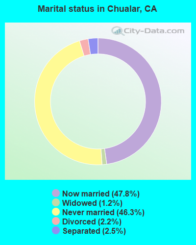
- Never married: 46.3%
- Now married: 47.8%
- Separated: 2.5%
- Widowed: 1.2%
- Divorced: 2.2%
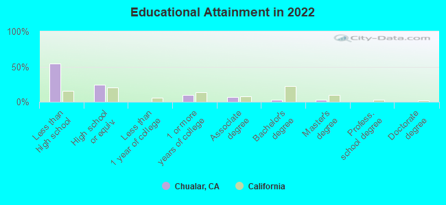
For population 25 years and over in Chualar:
- High school or higher: 45.0%
- Bachelor's degree or higher: 5.4%
- Graduate or professional degree: 2.3%
- Unemployed: 22.0%
- Mean travel time to work (commute): 30.9 minutes
| Here: | 25.0 |
| California average: | 15.5 |
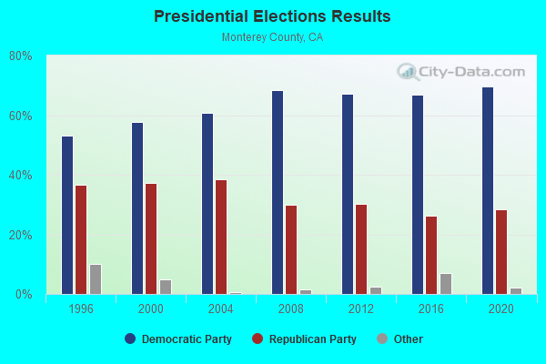

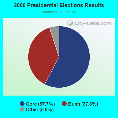
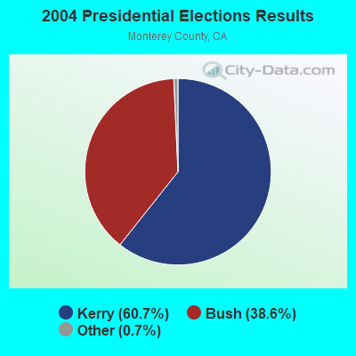
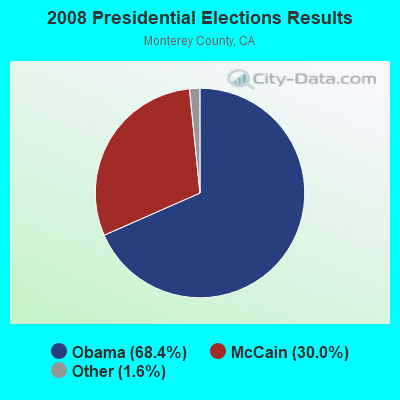
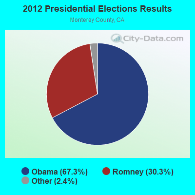
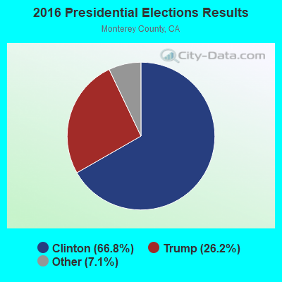
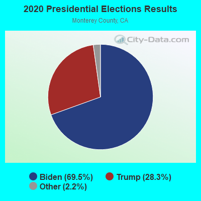
Graphs represent county-level data. Detailed 2008 Election Results
Religion statistics for Chualar, CA (based on Monterey County data)
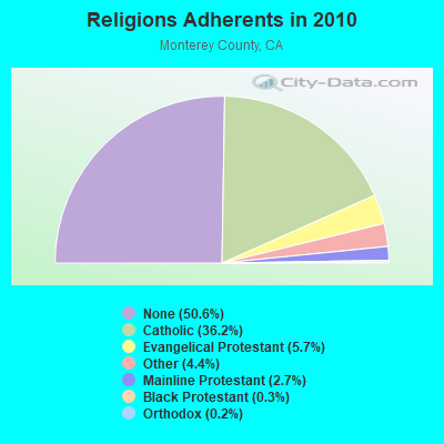
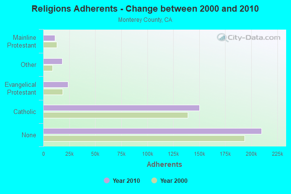
| Religion | Adherents | Congregations |
|---|---|---|
| Catholic | 150,050 | 26 |
| Evangelical Protestant | 23,624 | 154 |
| Other | 18,309 | 48 |
| Mainline Protestant | 11,244 | 48 |
| Black Protestant | 1,199 | 8 |
| Orthodox | 640 | 3 |
| None | 209,991 | - |
Food Environment Statistics:
| This county: | 2.82 / 10,000 pop. |
| California: | 2.14 / 10,000 pop. |
| Monterey County: | 0.05 / 10,000 pop. |
| California: | 0.04 / 10,000 pop. |
| This county: | 0.91 / 10,000 pop. |
| California: | 0.62 / 10,000 pop. |
| This county: | 2.00 / 10,000 pop. |
| California: | 1.49 / 10,000 pop. |
| This county: | 9.24 / 10,000 pop. |
| California: | 7.42 / 10,000 pop. |
| Monterey County: | 7.5% |
| California: | 7.3% |
| Here: | 21.8% |
| California: | 21.3% |
| Here: | 18.4% |
| California: | 17.9% |
Health and Nutrition:
| Here: | 40.4% |
| California: | 49.4% |
| Chualar: | 40.8% |
| California: | 48.0% |
| This city: | 27.9 |
| State: | 28.1 |
| Chualar: | 34.7% |
| State: | 20.2% |
| This city: | 7.6% |
| State: | 11.2% |
| Chualar: | 6.5 |
| State: | 6.8 |
| Here: | 23.2% |
| California: | 31.5% |
| Here: | 50.2% |
| California: | 56.4% |
| Chualar: | 79.9% |
| State: | 80.9% |
More about Health and Nutrition of Chualar, CA Residents
4.96% of this county's 2021 resident taxpayers lived in other counties in 2020 ($91,945 average adjusted gross income)
| Here: | 4.96% |
| California average: | 5.19% |
0.08% of residents moved from foreign countries ($1,276 average AGI)
Monterey County: 0.08% California average: 0.03%
Top counties from which taxpayers relocated into this county between 2020 and 2021:
| from Santa Cruz County, CA | |
| from Santa Clara County, CA | |
| from Los Angeles County, CA |
6.17% of this county's 2020 resident taxpayers moved to other counties in 2021 ($76,219 average adjusted gross income)
| Here: | 6.17% |
| California average: | 6.14% |
0.08% of residents moved to foreign countries ($1,055 average AGI)
Monterey County: 0.08% California average: 0.02%
Top counties to which taxpayers relocated from this county between 2020 and 2021:
| to Santa Cruz County, CA | |
| to Santa Clara County, CA | |
| to Los Angeles County, CA |
Strongest AM radio stations in Chualar:
- KKMC (880 AM; 10 kW; GONZALES, CA; Owner: MONTEREY COUNTY BROADCASTERS, INC.)
- KYAA (1200 AM; 25 kW; SOQUEL, CA; Owner: PEOPLE'S RADIO, INC.)
- KSRK (540 AM; 10 kW; CARMEL VALLEY, CA; Owner: PEOPLE'S RADIO, INC.)
- KTGE (1570 AM; 5 kW; SALINAS, CA; Owner: WOLFHOUSE RADIO GROUP, INC.)
- KDBV (980 AM; 10 kW; SALINAS, CA; Owner: WOLFHOUSE RADIO GROUP, INC.)
- KMBX (700 AM; 10 kW; SOLEDAD, CA; Owner: ENTRAVISION HOLDINGS, LLC)
- KION (1460 AM; 10 kW; SALINAS, CA)
- KTOM (1380 AM; 5 kW; SALINAS, CA; Owner: CLEAR CHANNEL BROADCASTING LICENSES, INC.)
- KLOK (1170 AM; 50 kW; SAN JOSE, CA; Owner: ENTRAVISION HOLDINGS, LLC)
- KNBR (680 AM; 50 kW; SAN FRANCISCO, CA; Owner: KNBR LICO, INC.)
- KGO (810 AM; 50 kW; SAN FRANCISCO, CA; Owner: KGO-AM RADIO, INC.)
- KMPG (1520 AM; daytime; 5 kW; HOLLISTER, CA; Owner: PROMO RADIO CORP.)
- KCBC (770 AM; 50 kW; RIVERBANK, CA; Owner: KIERTRON, INC.)
Strongest FM radio stations in Chualar:
- K260AA (99.9 FM; CARMEL VALLEY, CA; Owner: ENTRAVISION HOLDINGS, LLC)
- KUSP (88.9 FM; SANTA CRUZ, CA; Owner: PATAPHYSICAL B/CING. FOUNDATION,INC.)
- KWAV (96.9 FM; MONTEREY, CA; Owner: BUCKLEY BROADCASTING OF MONTEREY)
- KTOM-FM (100.7 FM; SALINAS, CA; Owner: CLEAR CHANNEL BROADCASTING LICENSES, INC.)
- K291AE (106.1 FM; SEASIDE, CA; Owner: MAPELTON COMMUNICATIONS, LLC)
- KDON-FM (102.5 FM; SALINAS, CA; Owner: CLEAR CHANNEL BROADCASTING LICENSES, INC.)
- K202DU (88.3 FM; SAN JUAN BAUTISTA, CA; Owner: CALVARY CHAPEL OF TWIN FALLS, INC.)
- KBTU (93.5 FM; HOLLISTER, CA; Owner: MAPLETON COMMUNICATIONS, L.L.C.)
- KLVM (89.7 FM; PRUNEDALE, CA; Owner: PRUNEDALE EDUCATIONAL ASSOCIATION)
- K265DG (100.9 FM; HOLLISTER, CA; Owner: CLEAR CHANNEL BROADCASTING LICENSES, INC.)
- K206BQ (89.1 FM; HOLLISTER, CA; Owner: PATAPHYSICAL BROADCASTING FOUNDATION, INC.)
- KSEA (107.9 FM; GREENFIELD, CA; Owner: FARMWORKER EDU'AL RADIO NETWORK, INC)
- K240AK (95.9 FM; SOLEDAD, CA; Owner: CALVARY CHAPEL OF TWIN FALLS, INC.)
- K265DK (100.9 FM; GREENFIELD, CA; Owner: CLEAR CHANNEL BROADCASTING LICENSES, INC.)
- KRAY-FM (103.5 FM; SALINAS, CA; Owner: WOLFHOUSE RADIO GROUP, INC.)
- KEBV (97.9 FM; SALINAS, CA; Owner: WOLFHOUSE RADIO GROUP, INC.)
- KHIP (104.3 FM; GONZALES, CA; Owner: MAPLETON COMMUNICATIONS, L.L.C.)
- KHRI (90.7 FM; HOLLISTER, CA; Owner: EDUCATIONAL MEDIA FOUNDATION)
- KHDC (90.9 FM; CHUALAR, CA; Owner: RADIO BILINGUE, INC.)
- KOCN (105.1 FM; PACIFIC GROVE, CA; Owner: CLEAR CHANNEL BROADCASTING LICENSES, INC.)
TV broadcast stations around Chualar:
- KMMD-CA (Channel 3; SALINAS, CA; Owner: CABALLERO TELEVISION TEXAS, L.L.C.)
- KION-TV (Channel 46; MONTEREY, CA; Owner: ACKERLEY MEDIA GROUP, INC.)
- KSBW (Channel 8; SALINAS, CA; Owner: HEARST-ARGYLE STATIONS, INC.)
- KCBA (Channel 35; SALINAS, CA; Owner: SEAL ROCK BROADCASTERS, L.L.C.)
- KCAH (Channel 25; WATSONVILLE, CA; Owner: KTEH FOUNDATION)
- K29AB (Channel 29; MONTEREY, ETC., CA; Owner: KTVU PARTNERSHIP)
- KMUV-LP (Channel 23; MONTEREY, CA; Owner: SAINTE PARTNERS II, L.P.)
- KSMS-TV (Channel 67; MONTEREY, CA; Owner: ENTRAVISION HOLDINGS, LLC)
- K15CU (Channel 15; SALINAS, CA; Owner: TELEMUNDO OF NORTHERN CALIFORNIA LIC. CORP.)
- K42DT (Channel 42; COALINGA, CA; Owner: VENTURE TECHNOLOGIES GROUP, LLC)
- KMCE-LP (Channel 43; MONTEREY, CA; Owner: SCOTTS VALLEY GROUP, INC. d/b as MARCOM)
- KMST-LP (Channel 59; GONZALES, CA; Owner: MONTEREY COUNTY SUPT. OF SCHOOLS)
- K59AY (Channel 59; HOLLISTER, CA; Owner: ACKERLEY MEDIA GROUP, INC.)
- K56AA (Channel 56; SALINAS, CA; Owner: MONTEREY CNTY SUPER. OF SCHOOLS)
- National Bridge Inventory (NBI) Statistics
- 3Number of bridges
- 118ft / 35.7mTotal length
- 60,700Total average daily traffic
- 8,821Total average daily truck traffic
FCC Registered Private Land Mobile Towers:
1- Mt Toro (Lat: 36.534694 Lon: -121.620500), Type: Tower, Structure height: 46 m, Overall height: 55 m, Call Sign: WPHB556,
Assigned Frequencies: 929.112 MHz, Grant Date: 04/22/2000, Expiration Date: 04/22/2010, Cancellation Date: 02/02/2010, Certifier: Shawn E Endsley, Registrant: Usa Mobility Wireless, Inc., 300 Technology Drive #400, Plano, TX 75074, Phone: (972) 801-1626, Fax: (972) 801-1699, Email:
FCC Registered Broadcast Land Mobile Towers:
4- 24281 Washington St (Lat: 36.571361 Lon: -121.517722), Call Sign: KNGE591,
Assigned Frequencies: 156.105 MHz, 154.370 MHz, Grant Date: 11/21/2023, Expiration Date: 01/25/2034, Registrant: County Of Monterey, 855 East Laurel Dr, Building D, Salinas, CA 93905, Phone: (831) 796-1364, Fax: (831) 796-1331, Email:
- Mt Toro 6 Mi Sw (Lat: 36.529417 Lon: -121.607722), Call Sign: WXR593, Licensee ID: L00017513,
Assigned Frequencies: 851.662 MHz, Grant Date: 09/03/1998, Expiration Date: 11/14/2003, Cancellation Date: 11/14/2001, Registrant: Hoagland Transport Service Inc, Modesto, CA 95353
- Salinas River Near Chualar (Lat: 36.555556 Lon: -121.548611), Type: Bant, Structure height: 2.4 m, Overall height: 3 m, Call Sign: WQGL630,
Assigned Frequencies: 170.262 MHz, Grant Date: 01/26/2017, Expiration Date: 02/23/2027, Certifier: Howard B Franklin, Registrant: Monterey County Water Resources Agency, 1441 Schilling Place, North Building, Salinas, CA 93901, Phone: (831) 755-4860, Fax: (831) 424-7935, Email:
- Lat: 36.572194 Lon: -121.516139, Call Sign: WRDP548,
Assigned Frequencies: 451.437 MHz, 452.662 MHz, 456.437 MHz, 457.662 MHz, Grant Date: 06/19/2019, Expiration Date: 06/19/2029, Certifier: Lucia Alvarez, Registrant: Silke Communications, 538 Brunken Avenue, Suite 4, Salinas, CA 93901, Phone: (831) 970-3283, Email:
FCC Registered Microwave Towers:
7 (See the full list of FCC Registered Microwave Towers in this town)FCC Registered Paging Towers:
1 (See the full list of FCC Registered Paging Towers)| Home Mortgage Disclosure Act Aggregated Statistics For Year 2008 (Based on 1 partial tract) | ||||
| B) Conventional Home Purchase Loans | C) Refinancings | |||
|---|---|---|---|---|
| Number | Average Value | Number | Average Value | |
| LOANS ORIGINATED | 0 | $0 | 0 | $0 |
| APPLICATIONS APPROVED, NOT ACCEPTED | 0 | $0 | 0 | $0 |
| APPLICATIONS DENIED | 1 | $108,070 | 0 | $0 |
| APPLICATIONS WITHDRAWN | 0 | $0 | 1 | $151,350 |
| FILES CLOSED FOR INCOMPLETENESS | 0 | $0 | 0 | $0 |
Detailed HMDA statistics for the following Tracts: 0108.02


| Most common first names in Chualar, CA among deceased individuals | ||
| Name | Count | Lived (average) |
|---|---|---|
| Maria | 6 | 77.5 years |
| Albert | 4 | 76.8 years |
| Juan | 4 | 73.5 years |
| Mariano | 3 | 84.7 years |
| Mary | 3 | 85.0 years |
| George | 2 | 86.5 years |
| Francisco | 2 | 57.5 years |
| Frank | 2 | 77.0 years |
| Fred | 2 | 89.5 years |
| Augustin | 2 | 57.0 years |
| Most common last names in Chualar, CA among deceased individuals | ||
| Last name | Count | Lived (average) |
|---|---|---|
| Johnson | 7 | 76.0 years |
| Mendez | 5 | 67.0 years |
| Turri | 4 | 82.7 years |
| Holguin | 3 | 61.7 years |
| Amaral | 3 | 83.3 years |
| Elliott | 3 | 58.1 years |
| Lopez | 3 | 77.3 years |
| Nana | 3 | 67.3 years |
| Onell | 3 | 78.6 years |
| Perez | 3 | 64.6 years |
Chualar compared to California state average:
- Median household income significantly below state average.
- Black race population percentage significantly below state average.
- Median age below state average.
- Length of stay since moving in significantly above state average.
- Number of college students below state average.
- Percentage of population with a bachelor's degree or higher significantly below state average.
Chualar on our top lists:
- #20 on the list of "Top 101 cities with the most cars per house, population 500+"
- #21 on the list of "Top 101 cities with the most residents born in Mexico (population 500+)"
- #26 on the list of "Top 101 cities with the most residents born in Central America (population 500+)"
- #47 on the list of "Top 101 cities with the most residents born in Latin America (population 500+)"
- #48 on the list of "Top 101 cities with the highest percentage of family households, population 1,000+"
- #48 on the list of "Top 101 cities with the most residents born in Americas (population 500+)"
- #20 (93925) on the list of "Top 101 zip codes with the largest percentage of taxpayers using paid preparers for 2012 taxes (pop 1,000+)"
- #15 on the list of "Top 101 counties with the highest Nitrogen Dioxide air pollution readings in 2012 (ppm)"
- #20 on the list of "Top 101 counties with the lowest surface withdrawal of fresh water for public supply (pop. 50,000+)"
- #33 on the list of "Top 101 counties with the highest number of births per 1000 residents 2007-2013"
- #44 on the list of "Top 101 counties with the lowest Particulate Matter (PM2.5) Annual air pollution readings in 2012 (µg/m3)"
- #54 on the list of "Top 101 counties with the highest Particulate Matter (PM10) Annual air pollution readings in 2012 (µg/m3)"
State forum archive:
- California Pages: 2 3 4 5 6 7 8 9 10 11 12 13 14 15 16 17 18 19 20 21 22 23 24 25 26 27 28 29 30 31 32 33 34 35 36 37 38 39 40 41 42 43 44 45 46 47 48 49 50 51 52 53 54 55 56 57 58 59 60 61 62 63 64 65 66 67 68 69 70 71 72 73 74 75 76 77 78 79
- Los Angeles Pages: 2 3 4 5 6 7 8 9 10 11 12 13 14 15 16 17 18 19 20 21 22 23 24 25 26 27 28 29 30 31 32 33 34 35 36 37 38 39 40 41 42 43 44 45 46 47 48 49 50 51 52 53 54 55 56 57 58 59 60 61 62 63 64 65 66 67 68 69 70 71 72 73 74 75 76 77 78 79 80 81 82 83 84 85 86 87 88 89 90 91 92 93 94 95 96 97 98 99 100 101 102 103 104 105 106 107 108 109 110 111 112 113 114 115 116 117 118 119 120 121 122 123
- Monterey County Pages: 2 3
- Orange County Pages: 2 3 4 5 6 7 8 9 10 11 12 13 14 15 16 17 18 19 20 21 22 23 24 25 26 27 28 29 30 31 32 33 34 35 36
- Sacramento Pages: 2 3 4 5 6 7 8 9 10 11 12 13 14 15 16 17 18 19 20 21 22 23 24 25 26 27 28 29 30 31 32
- San Bernardino and Riverside Counties Pages: 2 3 4 5 6 7 8 9 10 11 12 13 14 15 16 17 18 19 20 21 22 23
- San Diego Pages: 2 3 4 5 6 7 8 9 10 11 12 13 14 15 16 17 18 19 20 21 22 23 24 25 26 27 28 29 30 31 32 33 34 35 36 37 38 39 40 41 42 43 44 45 46 47 48 49 50 51 52 53 54 55 56 57 58 59 60 61 62 63 64 65 66 67 68 69 70 71 72 73 74 75 76
- San Francisco - Oakland Pages: 2 3 4 5 6 7 8 9 10 11 12 13 14 15 16 17 18 19 20 21 22 23 24 25 26 27 28 29 30 31 32 33 34 35 36 37 38 39 40 41 42 43 44 45 46 47 48 49 50 51 52 53 54 55 56 57 58 59 60 61 62 63 64 65 66 67 68 69 70 71 72
- San Jose Pages: 2 3 4 5 6 7 8 9 10 11 12 13 14 15 16 17 18 19 20 21 22 23 24
- Ventura County Pages: 2 3 4 5 6 7

|
Total of 2 patent applications in 2008-2024.