Amity, Maine
Submit your own pictures of this town and show them to the world
- OSM Map
- Google Map
- MSN Map
Population change since 2000: +19.6%
 |
| Males: 125 | |
| Females: 113 |
| Median resident age: | 45.9 years |
| Maine median age: | 43.0 years |
Zip code: 04471
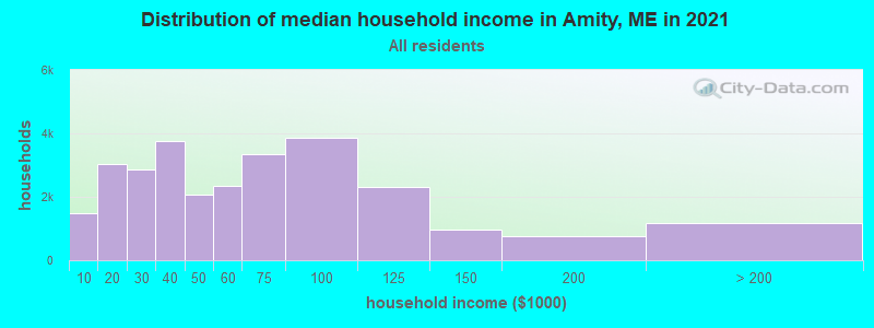
| Amity: | $47,527 |
| ME: | $69,543 |
Estimated per capita income in 2022: $27,828 (it was $13,484 in 2000)
Estimated median house or condo value in 2022: $132,441 (it was $54,700 in 2000)
| Amity: | $132,441 |
| ME: | $290,600 |
Mean prices in 2022: all housing units: $179,108; detached houses: $185,023; townhouses or other attached units: $218,327; in 2-unit structures: $262,505; in 3-to-4-unit structures: $121,406; in 5-or-more-unit structures: $185,084; mobile homes: $117,009; occupied boats, rvs, vans, etc.: $12,682
Detailed information about poverty and poor residents in Amity, ME
Compare current foreclosures near Amity, ME:
| Photo | Address | Area | Beds / Baths | Price | Details |
|---|---|---|---|---|---|

|
#1
Pleasant St
Houlton, ME 04730
|
1,977 sq. feet
|
1 baths 4 beds |
show details | |

|
#2
Watson Ave
Houlton, ME 04730
|
1 sq. feet
|
1 baths 3 beds |
show details | |

|
#3
High St # 2
Houlton, ME 04730
|
- sq. feet
|
- baths - beds |
show details | |

|
Check over 1 million property listings on Foreclosure.com!
|
browse all offers | |||

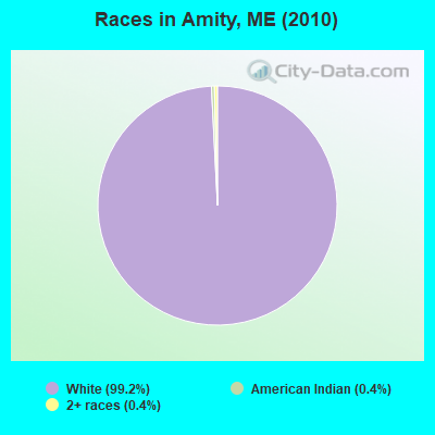
- 23699.2%White alone
- 10.4%American Indian alone
- 10.4%Two or more races
According to our research of Maine and other state lists, there was 1 registered sex offender living in Amity, Maine as of May 09, 2024.
The ratio of all residents to sex offenders in Amity is 238 to 1.
 Recent articles from our blog. Our writers, many of them Ph.D. graduates or candidates, create easy-to-read articles on a wide variety of topics.
Ancestries: English (41.2%), Irish (29.1%), French (22.6%), German (13.6%), Scottish (8.0%), Dutch (3.5%).
Current Local Time: EST time zone
Incorporated on 03/19/1836
Land area: 42.1 square miles.
Population density: 5.6 people per square mile (very low).
4 residents are foreign born (2.0% North America).
| This town: | 2.0% |
| Maine: | 2.9% |
| Amity town: | 0.9% ($500) |
| Maine: | 1.5% ($1,417) |
Nearest city with pop. 50,000+: Portland, ME  (196.6 miles , pop. 64,249).
Nearest city with pop. 200,000+: Boston, MA (296.9 miles , pop. 589,141).
Nearest city with pop. 1,000,000+: Bronx, NY (463.8 miles , pop. 1,332,650).
Nearest cities:
), )Latitude: 45.93 N, Longitude: 67.85 W
Area code commonly used in this area: 207
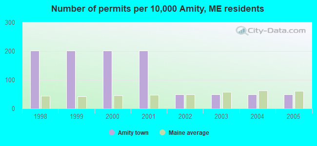
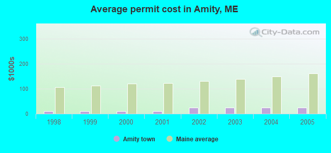
Single-family new house construction building permits:
- 2005: 1 building, cost: $25,000
- 2004: 1 building, cost: $25,000
- 2003: 1 building, cost: $25,000
- 2002: 1 building, cost: $25,000
- 2001: 4 buildings, average cost: $11,300
- 2000: 4 buildings, average cost: $11,300
- 1999: 4 buildings, average cost: $11,300
- 1998: 4 buildings, average cost: $11,300
| Here: | 5.7% |
| Maine: | 3.4% |


- Health care (16.4%)
- Agriculture, forestry, fishing & hunting (13.1%)
- Construction (9.8%)
- Professional, scientific, technical services (8.2%)
- Educational services (8.2%)
- Public administration (6.6%)
- Air transportation (4.9%)

- Agriculture, forestry, fishing & hunting (22.2%)
- Construction (16.7%)
- Air transportation (8.3%)
- Personal & laundry services (8.3%)
- Wood products (5.6%)
- Plastics & rubber products (5.6%)
- Metal & metal products (5.6%)

- Health care (32.0%)
- Public administration (16.0%)
- Professional, scientific, technical services (12.0%)
- Educational services (12.0%)
- Other direct selling establishments (8.0%)
- Administrative & support & waste management services (8.0%)
- Food & beverage stores (4.0%)

- Driver/sales workers and truck drivers (16.4%)
- Nursing, psychiatric, and home health aides (11.5%)
- Preschool, kindergarten, elementary, and middle school teachers (8.2%)
- Information and record clerks, except customer service representatives (6.6%)
- Financial clerks, except bookkeeping, accounting and auditing clerks (6.6%)
- Other production occupations, including supervisors (6.6%)
- Entertainers and performers, sports, and related workers (4.9%)

- Driver/sales workers and truck drivers (27.8%)
- Other production occupations, including supervisors (11.1%)
- Entertainers and performers, sports, and related workers (8.3%)
- Aircraft and traffic control occupations (8.3%)
- Preschool, kindergarten, elementary, and middle school teachers (5.6%)
- Counselors, social workers, and other community and social service specialists (5.6%)
- Nursing, psychiatric, and home health aides (5.6%)

- Nursing, psychiatric, and home health aides (20.0%)
- Information and record clerks, except customer service representatives (16.0%)
- Financial clerks, except bookkeeping, accounting and auditing clerks (16.0%)
- Preschool, kindergarten, elementary, and middle school teachers (12.0%)
- Computer specialists (12.0%)
- Cashiers (8.0%)
- Material recording, scheduling, dispatching, and distributing workers (8.0%)
Average climate in Amity, Maine
Based on data reported by over 4,000 weather stations


(lower is better)
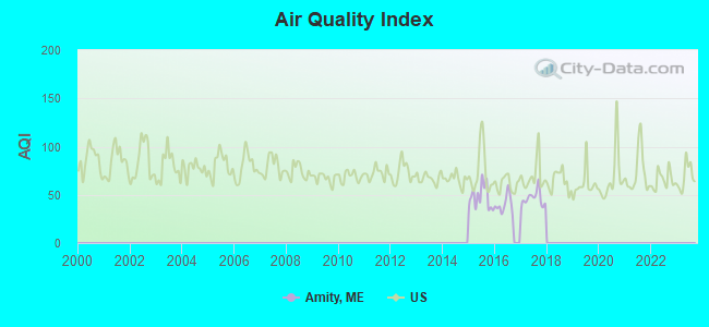
Air Quality Index (AQI) level in 2017 was 46.0. This is significantly better than average.
| City: | 46.0 |
| U.S.: | 72.6 |
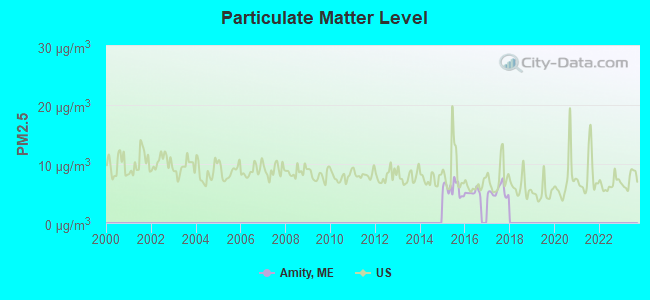
Particulate Matter (PM2.5) [µg/m3] level in 2017 was 5.39. This is significantly better than average. There were 0 monitors within city limits.
| City: | 5.39 |
| U.S.: | 8.11 |
Earthquake activity:
Amity-area historical earthquake activity is above Maine state average. It is 85% smaller than the overall U.S. average.On 4/20/2002 at 10:50:47, a magnitude 5.3 (5.3 ML, Depth: 3.0 mi, Class: Moderate, Intensity: VI - VII) earthquake occurred 301.2 miles away from the city center
On 4/20/2002 at 10:50:47, a magnitude 5.2 (5.2 MB, 4.2 MS, 5.2 MW, 5.0 MW) earthquake occurred 302.8 miles away from Amity center
On 10/16/2012 at 23:12:25, a magnitude 4.7 (4.7 ML, Depth: 10.0 mi, Class: Light, Intensity: IV - V) earthquake occurred 212.2 miles away from the city center
On 7/14/2006 at 09:34:48, a magnitude 3.9 (3.9 MD, Depth: 8.6 mi, Class: Light, Intensity: II - III) earthquake occurred 76.6 miles away from the city center
On 10/7/1983 at 10:18:46, a magnitude 5.3 (5.1 MB, 5.3 LG, 5.1 ML) earthquake occurred 345.9 miles away from Amity center
On 1/19/1982 at 00:14:42, a magnitude 4.7 (4.5 MB, 4.7 MD, 4.5 LG) earthquake occurred 249.4 miles away from the city center
Magnitude types: regional Lg-wave magnitude (LG), body-wave magnitude (MB), duration magnitude (MD), local magnitude (ML), surface-wave magnitude (MS), moment magnitude (MW)
Natural disasters:
The number of natural disasters in Aroostook County (22) is greater than the US average (15).Major Disasters (Presidential) Declared: 13
Emergencies Declared: 9
Causes of natural disasters: Floods: 10, Storms: 8, Snows: 7, Heavy Rains: 2, Blizzard: 1, Hurricane: 1, Ice Storm: 1, Snowfall: 1, Snowstorm: 1, Wind: 1, Winter Storm: 1, Other: 2 (Note: some incidents may be assigned to more than one category).
Hospitals and medical centers near Amity:
- HARMONY (Hospital, about 13 miles away; HOULTON, ME)
- FOREST SPRINGS (Hospital, about 13 miles away; HOULTON, ME)
- MADIGAN HOME HEALTH CARE, INC. (Home Health Center, about 14 miles away; HOULTON, ME)
- MADIGAN ESTATES (Nursing Home, about 14 miles away; HOULTON, ME)
- HOULTON REGIONAL HOSPITAL Critical Access Hospitals (about 14 miles away; HOULTON, ME)
- THE HOULTON REG PROG CARE FAC (Nursing Home, about 14 miles away; HOULTON, ME)
Colleges/universities with over 2000 students nearest to Amity:
- University of Maine (about 82 miles; Orono, ME; Full-time enrollment: 8,931)
- Husson University (about 89 miles; Bangor, ME; FT enrollment: 2,421)
- University of Maine at Farmington (about 142 miles; Farmington, ME; FT enrollment: 2,036)
- University of Maine at Augusta (about 146 miles; Augusta, ME; FT enrollment: 3,204)
- Saint Joseph's College of Maine (about 195 miles; Standish, ME; FT enrollment: 2,010)
- Southern Maine Community College (about 197 miles; South Portland, ME; FT enrollment: 4,666)
- University of Southern Maine (about 197 miles; Portland, ME; FT enrollment: 6,647)
Points of interest:
Church in Amity: Amity Baptist Church (A). Display/hide its location on the map
Cemeteries: Amity Cemetery (1), South Amity Cemetery (2), Spurr Cemetery (3), Estabrook Cemetery (4). Display/hide their locations on the map
Swamps: Davis Brook Bog (A). Display/hide its location on the map
Streams, rivers, and creeks: Tracy Brook (A), Second Brook (B), Williams Brook (C), Greenleaf Brook (D), First Brook (E), Jay Brook (F), Meadow Brook (G), Glendenning Brook (H), Moose Brook (I). Display/hide their locations on the map
| This town: | 2.3 people |
| Maine: | 2.3 people |
| This town: | 63.7% |
| Whole state: | 62.9% |
| This town: | 10.8% |
| Whole state: | 9.4% |
No gay or lesbian households reported
| This town: | 15.0% |
| Whole state: | 10.9% |
For population 15 years and over in Amity:
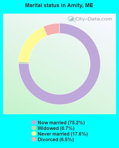
- Never married: 17.6%
- Now married: 75.2%
- Separated: 0.0%
- Widowed: 0.7%
- Divorced: 6.5%
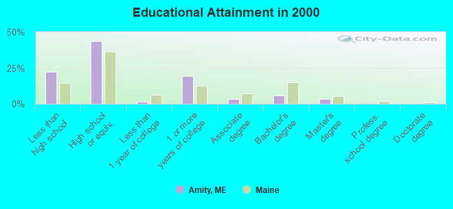
For population 25 years and over in Amity:
- High school or higher: 77.5%
- Bachelor's degree or higher: 9.4%
- Graduate or professional degree: 3.6%
- Unemployed: 12.9%
- Mean travel time to work (commute): 29.4 minutes

| Here: | 11.4 |
| Maine average: | 11.2 |


Graphs represent county-level data. Detailed 2008 Election Results
Religion statistics for Amity, ME (based on Aroostook County data)


| Religion | Adherents | Congregations |
|---|---|---|
| Catholic | 22,200 | 27 |
| Mainline Protestant | 5,845 | 40 |
| Evangelical Protestant | 4,411 | 51 |
| Other | 957 | 7 |
| Orthodox | 10 | 1 |
| None | 38,447 | - |
Food Environment Statistics:
| Aroostook County: | 4.03 / 10,000 pop. |
| Maine: | 2.80 / 10,000 pop. |
| This county: | 0.14 / 10,000 pop. |
| State: | 0.14 / 10,000 pop. |
| Aroostook County: | 2.22 / 10,000 pop. |
| Maine: | 2.20 / 10,000 pop. |
| Aroostook County: | 7.78 / 10,000 pop. |
| State: | 5.75 / 10,000 pop. |
| Here: | 9.17 / 10,000 pop. |
| State: | 11.02 / 10,000 pop. |
| This county: | 11.7% |
| Maine: | 8.2% |
| Aroostook County: | 27.6% |
| Maine: | 25.0% |
Strongest AM radio stations in Amity:
- WREM (710 AM; daytime; 5 kW; MONTICELLO, ME; Owner: ALLAN H WEINER)
- WFST (600 AM; 5 kW; CARIBOU, ME; Owner: NORTHERN BROADCAST MINISTRIES, INC.)
- WEGP (1390 AM; 5 kW; PRESQUE ISLE, ME; Owner: DECELLES/SMITH MEDIA, INC.)
- WZON (620 AM; 5 kW; BANGOR, ME; Owner: THE ZONE CORPORATION)
- WRKO (680 AM; 50 kW; BOSTON, MA; Owner: ENTERCOM BOSTON LICENSE, LLC)
- WABI (910 AM; 5 kW; BANGOR, ME; Owner: CLEAR CHANNEL BROADCASTING LICENSES, INC.)
- WEEI (850 AM; 50 kW; BOSTON, MA; Owner: ENTERCOM BOSTON LICENSE, LLC)
- WSKW (1160 AM; 10 kW; SKOWHEGAN, ME; Owner: MOUNTAIN WIRELESS, INCORPORATED)
- WNNZ (640 AM; 50 kW; WESTFIELD, MA; Owner: CLEAR CHANNEL BROADCASTING LICENSES, INC.)
- WCHP (760 AM; 35 kW; CHAMPLAIN, NY; Owner: CHAMPLAIN RADIO, INC.)
- WBZ (1030 AM; 50 kW; BOSTON, MA; Owner: INFINITY BROADCASTING OPERATIONS, INC.)
- WCRN (830 AM; 50 kW; WORCESTER, MA; Owner: CARTER BROADCASTING CORPORATION)
- WTME (780 AM; 10 kW; RUMFORD, ME; Owner: MOUNTAIN VALLEY BROADCASTING, INC.)
Strongest FM radio stations in Amity:
- WHOU-FM (100.1 FM; HOULTON, ME; Owner: COUNTY COMMUNICATIONS, INC.)
- WQHR (96.1 FM; PRESQUE ISLE, ME; Owner: CITADEL BROADCASTING COMPANY)
- WOZI (101.9 FM; PRESQUE ISLE, ME; Owner: CITADEL BROADCASTING COMPANY)
- WMEM (106.1 FM; PRESQUE ISLE, ME; Owner: MAINE PUBLIC BROADCASTING CORPORATION)
- National Bridge Inventory (NBI) Statistics
- 2Number of bridges
- 30ft / 8.7mTotal length
- 12,520Total average daily traffic
- 1,249Total average daily truck traffic
- 17,538Total future (year 2036) average daily traffic
FCC Registered Amateur Radio Licenses:
2- Call Sign: KB1EAN, Licensee ID: L00145653, Grant Date: 05/03/1999, Expiration Date: 05/03/2009, Cancellation Date: 04/05/2005, Registrant: Patricia A Miller, 1131 Estabrook Rd, Amity, ME 04471
- Call Sign: N1PAM, Previous Call Sign: KB1EAN, Licensee ID: L00145653, Grant Date: 04/05/2005, Expiration Date: 04/05/2015, Cancellation Date: 04/06/2017, Certifier: Patricia A Miller, Registrant: Patricia A Miller, 1131 Estabrook Rd, Amity, ME 04471
Amity compared to Maine state average:
- Median house value below state average.
- Black race population percentage significantly below state average.
- Hispanic race population percentage significantly below state average.
- Foreign-born population percentage below state average.
- Renting percentage significantly below state average.
- Length of stay since moving in significantly above state average.
- Number of rooms per house significantly below state average.
- House age significantly below state average.
- Number of college students below state average.
- Percentage of population with a bachelor's degree or higher significantly below state average.