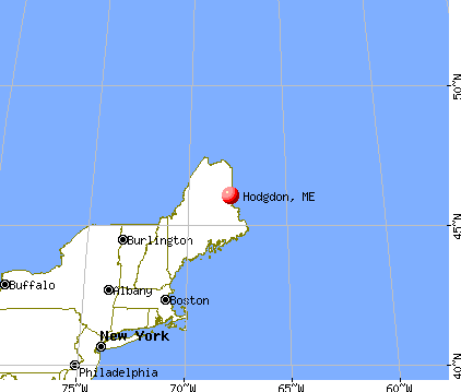
Hodgdon, Maine

Submit your own pictures of this town and show them to the world
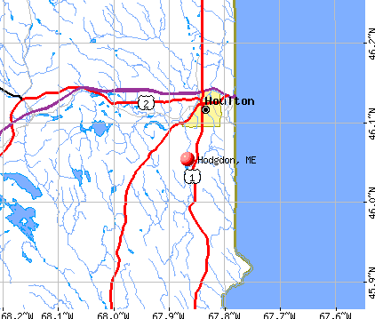
- OSM Map
- General Map
- Google Map
- MSN Map
Population change since 2000: +5.6%
 |
| Males: 661 | |
| Females: 648 |
| Median resident age: | 43.9 years |
| Maine median age: | 43.0 years |
Zip codes: 04730.
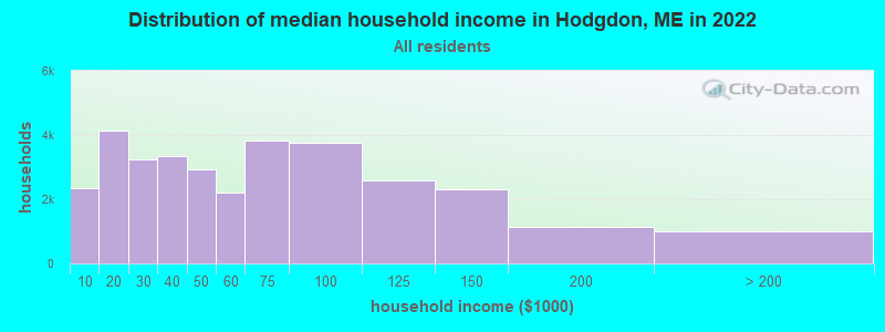
| Hodgdon: | $53,803 |
| ME: | $69,543 |
Estimated per capita income in 2022: $30,076 (it was $14,573 in 2000)
Hodgdon town income, earnings, and wages data
Estimated median house or condo value in 2022: $149,632 (it was $61,800 in 2000)
| Hodgdon: | $149,632 |
| ME: | $290,600 |
Mean prices in 2022: all housing units: $179,108; detached houses: $185,023; townhouses or other attached units: $218,327; in 2-unit structures: $262,505; in 3-to-4-unit structures: $121,406; in 5-or-more-unit structures: $185,084; mobile homes: $117,009; occupied boats, rvs, vans, etc.: $12,682
Detailed information about poverty and poor residents in Hodgdon, ME


- 1,25195.6%White alone
- 282.1%Two or more races
- 171.3%American Indian alone
- 90.7%Asian alone
- 30.2%Hispanic
- 10.08%Black alone
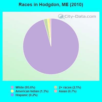
Races in Hodgdon detailed stats: ancestries, foreign born residents, place of birth
According to our research of Maine and other state lists, there were 5 registered sex offenders living in Hodgdon, Maine as of May 08, 2024.
The ratio of all residents to sex offenders in Hodgdon is 262 to 1.
 Recent articles from our blog. Our writers, many of them Ph.D. graduates or candidates, create easy-to-read articles on a wide variety of topics.

 | Honeymooned in Boothbay 20 years ago and agreed we would retire to Maine...Nervous (26 replies) |
| Maine Schools Are Open (13 replies) |
| Maine weather thread (3207 replies) |
| Rural Maine questions (North or Central) (24 replies) |
| Good driving distance from Houlton in winter? (10 replies) |
| Why do people think I'm nuts for wanting to move to Aroostook county? (60 replies) |
Latest news from Hodgdon, ME collected exclusively by city-data.com from local newspapers, TV, and radio stations
Ancestries: Irish (18.7%), English (16.8%), United States (13.5%), French (11.7%), Scottish (4.8%), German (4.5%).
Current Local Time: EST time zone
Incorporated on 02/11/1821
Elevation: 430 feet
Land area: 39.7 square miles.
Population density: 33 people per square mile (very low).
31 residents are foreign born (1.5% North America, 0.9% Europe).
| This town: | 2.5% |
| Maine: | 2.9% |
| Hodgdon town: | 1.2% ($770) |
| Maine: | 1.5% ($1,417) |
Nearest city with pop. 50,000+: Portland, ME  (203.3 miles , pop. 64,249).
Nearest city with pop. 200,000+: Boston, MA (304.0 miles , pop. 589,141).
Nearest city with pop. 1,000,000+: Bronx, NY (470.0 miles , pop. 1,332,650).
Nearest cities:
), ), ), ), )Latitude: 46.05 N, Longitude: 67.85 W
Area code commonly used in this area: 207

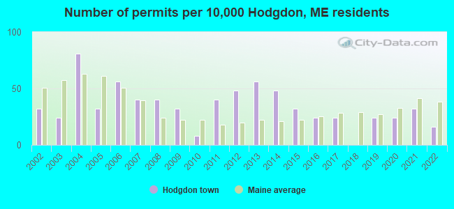
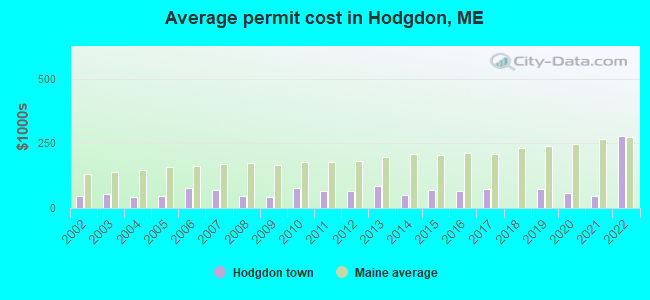
Single-family new house construction building permits:
- 2022: 2 buildings, average cost: $279,200
- 2021: 4 buildings, average cost: $44,500
- 2020: 3 buildings, average cost: $60,000
- 2019: 3 buildings, average cost: $71,700
- 2017: 3 buildings, average cost: $71,700
- 2016: 3 buildings, average cost: $66,000
- 2015: 4 buildings, average cost: $70,900
- 2014: 6 buildings, average cost: $51,700
- 2013: 7 buildings, average cost: $85,000
- 2012: 6 buildings, average cost: $63,800
- 2011: 5 buildings, average cost: $65,200
- 2010: 1 building, cost: $78,000
- 2009: 4 buildings, average cost: $42,900
- 2008: 5 buildings, average cost: $47,800
- 2007: 5 buildings, average cost: $70,000
- 2006: 7 buildings, average cost: $77,300
- 2005: 4 buildings, average cost: $45,000
- 2004: 10 buildings, average cost: $41,900
- 2003: 3 buildings, average cost: $53,300
- 2002: 4 buildings, average cost: $45,000
| Here: | 2.6% |
| Maine: | 3.4% |
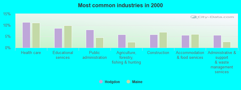
- Health care (11.2%)
- Educational services (8.6%)
- Public administration (7.9%)
- Agriculture, forestry, fishing & hunting (5.8%)
- Construction (5.8%)
- Accommodation & food services (5.6%)
- Administrative & support & waste management services (5.6%)
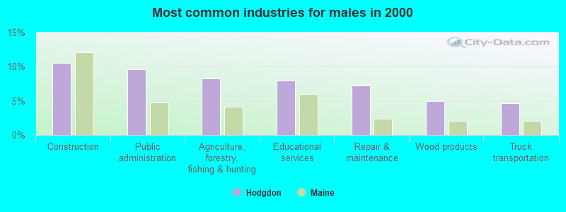
- Construction (10.6%)
- Public administration (9.6%)
- Agriculture, forestry, fishing & hunting (8.3%)
- Educational services (7.9%)
- Repair & maintenance (7.3%)
- Wood products (5.0%)
- Truck transportation (4.6%)
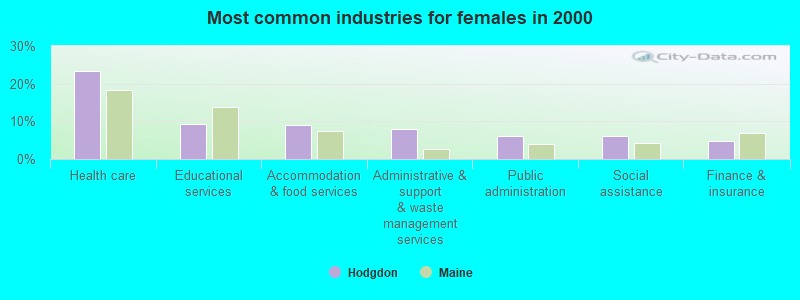
- Health care (23.3%)
- Educational services (9.4%)
- Accommodation & food services (9.0%)
- Administrative & support & waste management services (7.9%)
- Public administration (6.0%)
- Social assistance (6.0%)
- Finance & insurance (4.9%)
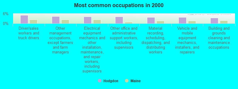
- Driver/sales workers and truck drivers (5.1%)
- Other management occupations, except farmers and farm managers (4.4%)
- Electrical equipment mechanics and other installation, maintenance, and repair workers, including supervisors (4.2%)
- Other office and administrative support workers, including supervisors (4.2%)
- Material recording, scheduling, dispatching, and distributing workers (3.9%)
- Vehicle and mobile equipment mechanics, installers, and repairers (3.9%)
- Building and grounds cleaning and maintenance occupations (3.5%)
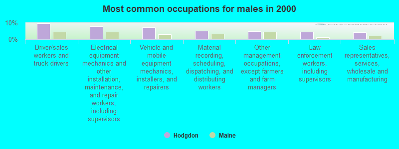
- Driver/sales workers and truck drivers (9.6%)
- Electrical equipment mechanics and other installation, maintenance, and repair workers, including supervisors (7.9%)
- Vehicle and mobile equipment mechanics, installers, and repairers (7.3%)
- Material recording, scheduling, dispatching, and distributing workers (5.3%)
- Other management occupations, except farmers and farm managers (5.0%)
- Law enforcement workers, including supervisors (4.6%)
- Sales representatives, services, wholesale and manufacturing (4.3%)

- Other office and administrative support workers, including supervisors (8.3%)
- Secretaries and administrative assistants (7.1%)
- Nursing, psychiatric, and home health aides (6.8%)
- Health technologists and technicians (6.0%)
- Registered nurses (5.6%)
- Preschool, kindergarten, elementary, and middle school teachers (4.9%)
- Cooks and food preparation workers (4.9%)
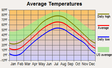
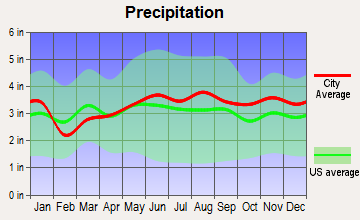
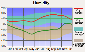
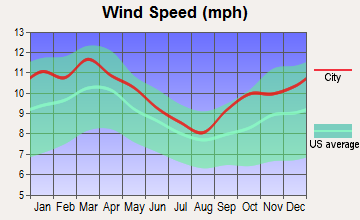
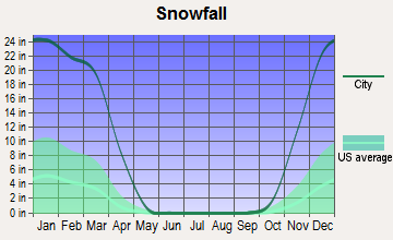
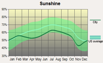
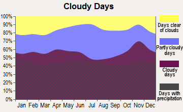
Average climate in Hodgdon, Maine
Based on data reported by over 4,000 weather stations
(lower is better)
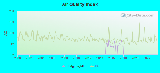
Air Quality Index (AQI) level in 2017 was 46.0. This is significantly better than average.
| City: | 46.0 |
| U.S.: | 72.6 |
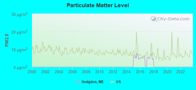
Particulate Matter (PM2.5) [µg/m3] level in 2017 was 5.39. This is significantly better than average. There were 0 monitors within city limits.
| City: | 5.39 |
| U.S.: | 8.11 |
Earthquake activity:
Hodgdon-area historical earthquake activity is above Maine state average. It is 85% smaller than the overall U.S. average.On 4/20/2002 at 10:50:47, a magnitude 5.3 (5.3 ML, Depth: 3.0 mi, Class: Moderate, Intensity: VI - VII) earthquake occurred 303.9 miles away from Hodgdon center
On 4/20/2002 at 10:50:47, a magnitude 5.2 (5.2 MB, 4.2 MS, 5.2 MW, 5.0 MW) earthquake occurred 305.5 miles away from Hodgdon center
On 10/16/2012 at 23:12:25, a magnitude 4.7 (4.7 ML, Depth: 10.0 mi, Class: Light, Intensity: IV - V) earthquake occurred 218.6 miles away from the city center
On 7/14/2006 at 09:34:48, a magnitude 3.9 (3.9 MD, Depth: 8.6 mi, Class: Light, Intensity: II - III) earthquake occurred 69.6 miles away from the city center
On 10/7/1983 at 10:18:46, a magnitude 5.3 (5.1 MB, 5.3 LG, 5.1 ML) earthquake occurred 349.1 miles away from Hodgdon center
On 1/19/1982 at 00:14:42, a magnitude 4.7 (4.5 MB, 4.7 MD, 4.5 LG) earthquake occurred 255.1 miles away from Hodgdon center
Magnitude types: regional Lg-wave magnitude (LG), body-wave magnitude (MB), duration magnitude (MD), local magnitude (ML), surface-wave magnitude (MS), moment magnitude (MW)
Natural disasters:
The number of natural disasters in Aroostook County (22) is greater than the US average (15).Major Disasters (Presidential) Declared: 13
Emergencies Declared: 9
Causes of natural disasters: Floods: 10, Storms: 8, Snows: 7, Heavy Rains: 2, Blizzard: 1, Hurricane: 1, Ice Storm: 1, Snowfall: 1, Snowstorm: 1, Wind: 1, Winter Storm: 1, Other: 2 (Note: some incidents may be assigned to more than one category).
Hospitals and medical centers near Hodgdon:
- HARMONY (Hospital, about 5 miles away; HOULTON, ME)
- FOREST SPRINGS (Hospital, about 5 miles away; HOULTON, ME)
- MADIGAN HOME HEALTH CARE, INC. (Home Health Center, about 6 miles away; HOULTON, ME)
- MADIGAN ESTATES (Nursing Home, about 6 miles away; HOULTON, ME)
- HOULTON REGIONAL HOSPITAL Critical Access Hospitals (about 6 miles away; HOULTON, ME)
- THE HOULTON REG PROG CARE FAC (Nursing Home, about 6 miles away; HOULTON, ME)
Colleges/universities with over 2000 students nearest to Hodgdon:
- University of Maine (about 90 miles; Orono, ME; Full-time enrollment: 8,931)
- Husson University (about 97 miles; Bangor, ME; FT enrollment: 2,421)
- University of Maine at Farmington (about 148 miles; Farmington, ME; FT enrollment: 2,036)
- University of Maine at Augusta (about 152 miles; Augusta, ME; FT enrollment: 3,204)
- Saint Joseph's College of Maine (about 201 miles; Standish, ME; FT enrollment: 2,010)
- Southern Maine Community College (about 204 miles; South Portland, ME; FT enrollment: 4,666)
- University of Southern Maine (about 204 miles; Portland, ME; FT enrollment: 6,647)
Public high school in Hodgdon:
- SAD 70 HODGDON HIGH SCHOOL (Location: 175 HODGDON MILLS ROAD, Grades: 9-12)
Public elementary/middle school in Hodgdon:
User-submitted facts and corrections:
- Please add the following under 'strongest FM stations in Hodgdon, ME': W229AT, 93.7 FM, Hodgdon, ME; Owner: Bangor Baptist Church
Points of interest:
Notable locations in Hodgdon: Union Corners (A), Hodgdon Volunteer Fire Department (B). Display/hide their locations on the map
Churches in Hodgdon include: Maranatha Church (A), Union Church (B). Display/hide their locations on the map
Cemeteries: Union Church Cemetery (1), Hodgdon Cemetery (2). Display/hide their locations on the map
Reservoir: South Branch Meduxnekeag River Reservoir (A). Display/hide its location on the map
Streams, rivers, and creeks: Stewart Brook (A), Tracy Brook (B), Stone Brook (C), Maduskeag Stream (D), Meduxnekeag Stream (E). Display/hide their locations on the map
Birthplace of: George Otis Smith - Geologist, Roger Sherman (politician) - Maine State Senator.
Drinking water stations with addresses in Hodgdon and their reported violations in the past:
MSAD 70 HODGDON HIGH SCHOOL (Population served: 187, Groundwater):Past health violations:HODGDON HOMESTEAD (Population served: 33, Groundwater):
- MCL, Monthly (TCR) - In SEP-2011, Contaminant: Coliform. Follow-up actions: St Public Notif requested (SEP-19-2011), St Formal NOV issued (SEP-19-2011), St Public Notif received (OCT-07-2011), St Compliance achieved (APR-29-2013)
Past health violations:Past monitoring violations:
- Public Education - In JAN-01-2008, Contaminant: Lead and Copper Rule. Follow-up actions: St Public Notif requested (APR-02-2009), St Formal NOV issued (APR-02-2009), St Public Notif received (JUN-12-2009), St Compliance achieved (JUL-28-2009)
- Public Education - In JAN-01-2007, Contaminant: Lead and Copper Rule. Follow-up actions: St Public Notif requested (APR-02-2009), St Formal NOV issued (APR-02-2009), St Public Notif received (JUN-12-2009), St Compliance achieved (JUL-28-2009)
- OCCT/SOWT Study/Recommendation - In SEP-30-2005, Contaminant: Lead and Copper Rule. Follow-up actions: St Violation/Reminder Notice (MAR-07-2006), St Compliance achieved (MAR-16-2006)
- Follow-up Or Routine LCR Tap M/R - In JAN-01-2012, Contaminant: Lead and Copper Rule. Follow-up actions: St Public Notif requested (FEB-27-2012), St Formal NOV issued (FEB-27-2012), St Compliance achieved (JUN-20-2012), St Public Notif received (SEP-25-2012)
- Monitoring and Reporting (DBP) - Between JAN-2008 and DEC-2010, Contaminant: Total Haloacetic Acids (HAA5). Follow-up actions: St Public Notif requested (NOV-16-2010), St Formal NOV issued (NOV-16-2010), St Public Notif received (JUN-17-2011), St Compliance achieved (JUL-18-2011)
- Monitoring and Reporting (DBP) - Between JAN-2008 and DEC-2010, Contaminant: TTHM. Follow-up actions: St Public Notif requested (NOV-16-2010), St Formal NOV issued (NOV-16-2010), St Public Notif received (JUN-17-2011), St Compliance achieved (JUL-18-2011)
- Follow-up Or Routine LCR Tap M/R - In JAN-11-2006, Contaminant: Lead and Copper Rule. Follow-up actions: St Public Notif requested (JAN-11-2006), St Violation/Reminder Notice (JAN-11-2006), St Compliance achieved (MAR-16-2006), St Public Notif received (MAR-16-2006)
- Water Quality Parameter M/R - Between JAN-2006 and JUN-2006, Contaminant: Lead and Copper Rule. Follow-up actions: St Public Notif requested (DEC-26-2006), St Violation/Reminder Notice (DEC-26-2006), St Compliance achieved (AUG-29-2011), St Intentional no-action (SEP-15-2011)
- 4 routine major monitoring violations
Drinking water stations with addresses in Hodgdon that have no violations reported:
- MSAD 70 HODGDON ELEM SCHOOL (Population served: 390, Primary Water Source Type: Groundwater)
| This town: | 2.5 people |
| Maine: | 2.3 people |
| This town: | 72.2% |
| Whole state: | 62.9% |
| This town: | 7.2% |
| Whole state: | 9.4% |
No gay or lesbian households reported
| This town: | 17.4% |
| Whole state: | 10.9% |
| This town: | 6.3% |
| Whole state: | 4.1% |
2 people in other group homes in 2000
For population 15 years and over in Hodgdon:
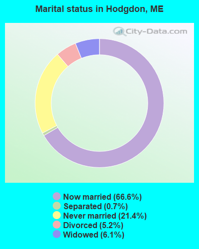
- Never married: 21.4%
- Now married: 66.6%
- Separated: 0.7%
- Widowed: 6.1%
- Divorced: 5.2%
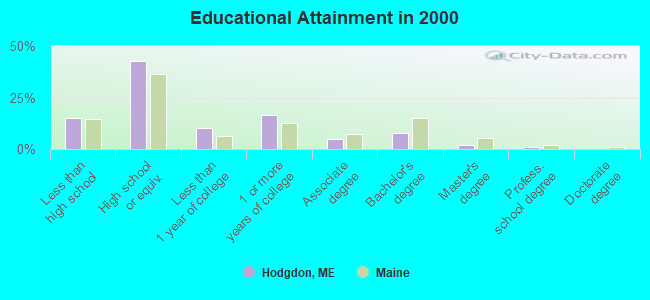
For population 25 years and over in Hodgdon:
- High school or higher: 85.0%
- Bachelor's degree or higher: 10.5%
- Graduate or professional degree: 2.9%
- Unemployed: 5.0%
- Mean travel time to work (commute): 18.5 minutes
| Here: | 9.2 |
| Maine average: | 11.2 |


Graphs represent county-level data. Detailed 2008 Election Results
Religion statistics for Hodgdon, ME (based on Aroostook County data)


| Religion | Adherents | Congregations |
|---|---|---|
| Catholic | 22,200 | 27 |
| Mainline Protestant | 5,845 | 40 |
| Evangelical Protestant | 4,411 | 51 |
| Other | 957 | 7 |
| Orthodox | 10 | 1 |
| None | 38,447 | - |
Food Environment Statistics:
| Aroostook County: | 4.03 / 10,000 pop. |
| Maine: | 2.80 / 10,000 pop. |
| This county: | 0.14 / 10,000 pop. |
| Maine: | 0.14 / 10,000 pop. |
| Aroostook County: | 2.22 / 10,000 pop. |
| Maine: | 2.20 / 10,000 pop. |
| This county: | 7.78 / 10,000 pop. |
| Maine: | 5.75 / 10,000 pop. |
| This county: | 9.17 / 10,000 pop. |
| Maine: | 11.02 / 10,000 pop. |
| This county: | 11.7% |
| Maine: | 8.2% |
| This county: | 27.6% |
| State: | 25.0% |
Strongest AM radio stations in Hodgdon:
- WREM (710 AM; daytime; 5 kW; MONTICELLO, ME; Owner: ALLAN H WEINER)
- WFST (600 AM; 5 kW; CARIBOU, ME; Owner: NORTHERN BROADCAST MINISTRIES, INC.)
- WEGP (1390 AM; 5 kW; PRESQUE ISLE, ME; Owner: DECELLES/SMITH MEDIA, INC.)
- WZON (620 AM; 5 kW; BANGOR, ME; Owner: THE ZONE CORPORATION)
- WRKO (680 AM; 50 kW; BOSTON, MA; Owner: ENTERCOM BOSTON LICENSE, LLC)
- WEEI (850 AM; 50 kW; BOSTON, MA; Owner: ENTERCOM BOSTON LICENSE, LLC)
- WNNZ (640 AM; 50 kW; WESTFIELD, MA; Owner: CLEAR CHANNEL BROADCASTING LICENSES, INC.)
- WCHP (760 AM; 35 kW; CHAMPLAIN, NY; Owner: CHAMPLAIN RADIO, INC.)
- WABI (910 AM; 5 kW; BANGOR, ME; Owner: CLEAR CHANNEL BROADCASTING LICENSES, INC.)
- WSKW (1160 AM; 10 kW; SKOWHEGAN, ME; Owner: MOUNTAIN WIRELESS, INCORPORATED)
- WBZ (1030 AM; 50 kW; BOSTON, MA; Owner: INFINITY BROADCASTING OPERATIONS, INC.)
- WCRN (830 AM; 50 kW; WORCESTER, MA; Owner: CARTER BROADCASTING CORPORATION)
- WTME (780 AM; 10 kW; RUMFORD, ME; Owner: MOUNTAIN VALLEY BROADCASTING, INC.)
Strongest FM radio stations in Hodgdon:
- WHOU-FM (100.1 FM; HOULTON, ME; Owner: COUNTY COMMUNICATIONS, INC.)
- WQHR (96.1 FM; PRESQUE ISLE, ME; Owner: CITADEL BROADCASTING COMPANY)
- WOZI (101.9 FM; PRESQUE ISLE, ME; Owner: CITADEL BROADCASTING COMPANY)
- WMEM (106.1 FM; PRESQUE ISLE, ME; Owner: MAINE PUBLIC BROADCASTING CORPORATION)
- WBPW (96.9 FM; PRESQUE ISLE, ME; Owner: CITADEL BROADCASTING COMPANY)
Hodgdon fatal accident list:
Sep 3, 2004 10:40 PM, Skedgell Road, Vehicles: 1, Persons: 1, Fatalities: 1
May 16, 1993 04:40 PM, Hodgdon, Vehicles: 1, Persons: 3, Fatalities: 1, Drunk persons involved: 1
Aug 27, 1979 10:47 PM, Vehicles: 1, Persons: 1, Fatalities: 1
- National Bridge Inventory (NBI) Statistics
- 1Number of bridges
- 7ft / 1.8mTotal length
- 1,720Total average daily traffic
- 223Total average daily truck traffic
- 2,060Total future (year 2038) average daily traffic
FCC Registered Antenna Towers:
6- Mark L Gartley, Westford Hill Road (Lat: 46.036806 Lon: -67.856111), Type: 93.2, Overall height: 91.4 m, Registrant: Holland & Knight LLP, Pconnolly@hklaw.Com, , Washi-ngton, Phone: (202) 862-5989
- Mark L Gartley, Westford Hill Road (Lat: 46.036806 Lon: -67.856111), Type: 93.2, Overall height: 91.4 m, Registrant: Holland & Knight LLP, Pconnolly@hklaw.Com, , Washi-ngton, Phone: (202) 862-5989
- Cayla Gamble, Westford Hill Road (Lat: 46.036806 Lon: -67.856111), Type: 93.2, Structure height: 23003 m, Overall height: 91.4 m, Registrant: Wilkinson Barker Knauer, LLP, Gwerner@wbklaw.Com, , Washi-ngton, Phone: (202) 383-3420
- Cayla Gamble, Westford Hill Road (Lat: 46.036806 Lon: -67.856111), Type: 93.3, Structure height: 23003 m, Overall height: 91.4 m, Registrant: Wilkinson Barker Knauer, LLP, Gwerner@wbklaw.Com, , Washi-ngton, Phone: (202) 383-3420
- Cayla Gamble, Westford Hill Road (Lat: 46.036806 Lon: -67.856111), Type: 93.3, Structure height: 23003 m, Overall height: 91.4 m, Registrant: Wilkinson Barker Knauer, LLP, Gwerner@wbklaw.Com, , Washi-ngton, Phone: (202) 383-3420
- Cayla Gamble, Westford Hill Road (Lat: 46.036806 Lon: -67.856111), Type: 93.3, Structure height: 23003 m, Overall height: 91.4 m, Registrant: Wilkinson Barker Knauer, LLP, Gwerner@wbklaw.Com, , Washi-ngton, Phone: (202) 383-3420
FCC Registered Broadcast Land Mobile Towers:
1- Us Border Patrol Us Rt 1 (Lat: 46.088944 Lon: -67.841139), Call Sign: WZT823,
Assigned Frequencies: 154.695 MHz, 154.710 MHz, 154.845 MHz, Grant Date: 02/06/2015, Expiration Date: 01/17/2025, Registrant: State Of Maine, O.I.T., Radio Operations, 66 Industrial Drive, Augusta, ME 04333-0147, Phone: (207) 624-9990, Email:
FCC Registered Microwave Towers:
2- NORTH AMITY_USF, Westford Hill Road (Lat: 46.036806 Lon: -67.856111), Type: Tower, Structure height: 91.4 m, Overall height: 93.2 m, Call Sign: WQHZ277,
Assigned Frequencies: 6615.00 MHz, Grant Date: 12/05/2017, Expiration Date: 12/04/2027, Cancellation Date: 04/05/2019, Certifier: John E Rooney, Registrant: Holland & Knight LLP, 800 17th Street, N.W., Suite 1100, Washington, DC 20006-3906, Phone: (202) 955-3000, Fax: (202) 955-5564, Email:
- Hodgdon, 25 Westford Hill Road (Lat: 46.036806 Lon: -67.856111), Type: Gtower, Structure height: 91.4 m, Overall height: 92.7 m, Call Sign: WQUR926,
Assigned Frequencies: 11225.0 MHz, 11225.0 MHz, 11225.0 MHz, 11225.0 MHz, 11225.0 MHz, 11225.0 MHz, 11225.0 MHz, 11225.0 MHz, 11225.0 MHz, Grant Date: 09/24/2014, Expiration Date: 09/24/2024, Cancellation Date: 07/24/2020, Certifier: Jessica B Lyons, Registrant: At&t Services, Inc., 208 S. Akard Street, Room 2100, Dallas, TX 75202, Phone: (855) 699-7073, Email:
FCC Registered Amateur Radio Licenses:
3- Call Sign: KA9DRW, Licensee ID: L01066893, Grant Date: 07/09/2015, Expiration Date: 09/27/2025, Certifier: David E Mueller, Registrant: David E Mueller, 324 Calais Rd, Hodgdon, ME 04730
- Call Sign: KB1LBP, Licensee ID: L00837397, Grant Date: 01/02/2014, Expiration Date: 03/26/2024, Certifier: Herbert E Carlow Jr, Registrant: Herbert E Carlow Jr, 680 Jackins Settlement Rd, Hodgdon, ME 04730
- Call Sign: KB1LGJ, Licensee ID: L00854228, Grant Date: 03/07/2024, Expiration Date: 04/27/2034, Certifier: Barrett T Quint, Registrant: Barrett T Quint, 22 Catalina Rd, Hodgdon, ME 04730
FAA Registered Aircraft:
1- Aircraft: FLIGHTSTAR AIRPLANE IISC (Category: Land, Seats: 2, Weight: Up to 12,499 Pounds), Engine: HKS 700E (60 HP) (4 Cycle)
N-Number: 422AQ, N422AQ, N-422AQ, Serial Number: 341, Year manufactured: 2002, Airworthiness Date: 12/19/2007, Certificate Issue Date: 04/24/2006
Registrant (Individual): Andrew O Quint, 39 Catalina Rd, Hodgdon, ME 04730
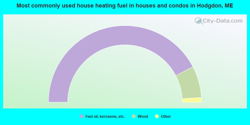
- 84.7%Fuel oil, kerosene, etc.
- 13.4%Wood
- 1.4%Coal or coke
- 0.5%Bottled, tank, or LP gas
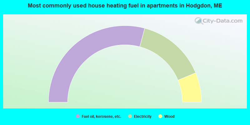
- 58.3%Fuel oil, kerosene, etc.
- 29.2%Electricity
- 12.5%Wood
Hodgdon compared to Maine state average:
- Median house value below state average.
- Unemployed percentage below state average.
- Black race population percentage significantly below state average.
- Hispanic race population percentage significantly below state average.
- Length of stay since moving in significantly above state average.
- Number of rooms per house significantly below state average.
- House age significantly below state average.
- Number of college students below state average.
- Percentage of population with a bachelor's degree or higher significantly below state average.
Hodgdon on our top lists:
- #36 on the list of "Top 101 cities with the largest percentage of people in homes for abused, dependent, and neglected children (population 1,000+)"
- #19 on the list of "Top 101 counties with the highest carbon monoxide air pollution readings in 2012 (ppm)"
- #22 on the list of "Top 101 counties with the smallest number of children under 18 without health insurance coverage in 2000 (pop. 50,000+)"
- #29 on the list of "Top 101 counties with the lowest percentage of residents relocating from other counties between 2010 and 2011"
- #34 on the list of "Top 101 counties with the lowest percentage of residents relocating to other counties in 2011"
- #46 on the list of "Top 101 counties with the lowest Particulate Matter (PM2.5) Annual air pollution readings in 2012 (µg/m3)"