New Limerick, Maine
Submit your own pictures of this town and show them to the world
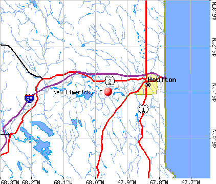
- OSM Map
- General Map
- Google Map
- MSN Map
Population change since 2000: -2.5%
 |
| Males: 244 | |
| Females: 266 |
| Median resident age: | 51.4 years |
| Maine median age: | 43.0 years |
Zip codes: 04730.
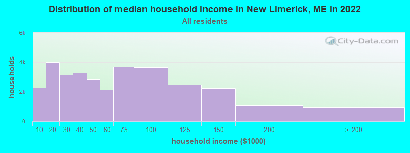
| New Limerick: | $52,195 |
| ME: | $69,543 |
Estimated per capita income in 2022: $30,833 (it was $14,940 in 2000)
New Limerick town income, earnings, and wages data
Estimated median house or condo value in 2022: $179,898 (it was $74,300 in 2000)
| New Limerick: | $179,898 |
| ME: | $290,600 |
Mean prices in 2022: all housing units: $179,108; detached houses: $185,023; townhouses or other attached units: $218,327; in 2-unit structures: $262,505; in 3-to-4-unit structures: $121,406; in 5-or-more-unit structures: $185,084; mobile homes: $117,009; occupied boats, rvs, vans, etc.: $12,682
Detailed information about poverty and poor residents in New Limerick, ME


- 50198.2%White alone
- 51.0%Two or more races
- 20.4%Black alone
- 20.4%Hispanic
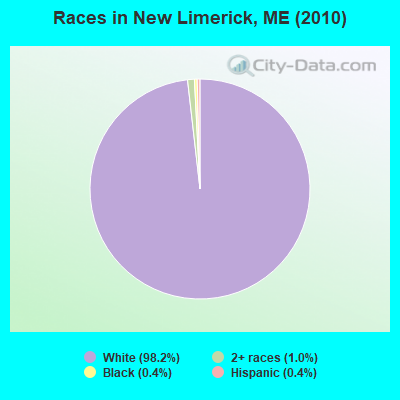
Races in New Limerick detailed stats: ancestries, foreign born residents, place of birth
 Recent articles from our blog. Our writers, many of them Ph.D. graduates or candidates, create easy-to-read articles on a wide variety of topics.

 | Good driving distance from Houlton in winter? (10 replies) |
| Why do people think I'm nuts for wanting to move to Aroostook county? (60 replies) |
| Maine Made Axes (3 replies) |
| Information about Houlton and area?? (15 replies) |
| high taxes in maine (36 replies) |
| Merrill Maine here we come (a continuation of the post abt Aroostook) (6 replies) |
Latest news from New Limerick, ME collected exclusively by city-data.com from local newspapers, TV, and radio stations
Ancestries: English (23.5%), United States (19.7%), Irish (15.9%), French (11.1%), Scottish (2.9%), German (2.5%).
Current Local Time: EST time zone
Elevation: 398 feet
Land area: 18.5 square miles.
Population density: 28 people per square mile (very low).
24 residents are foreign born (3.3% North America, 1.0% Asia).
| This town: | 4.6% |
| Maine: | 2.9% |
| New Limerick town: | 1.0% ($711) |
| Maine: | 1.5% ($1,417) |
Nearest city with pop. 50,000+: Portland, ME  (203.1 miles , pop. 64,249).
Nearest city with pop. 200,000+: Boston, MA (304.2 miles , pop. 589,141).
Nearest city with pop. 1,000,000+: Bronx, NY (469.0 miles , pop. 1,332,650).
Nearest cities:
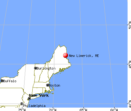
), ), ), )Latitude: 46.11 N, Longitude: 67.98 W
Area code commonly used in this area: 207

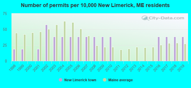
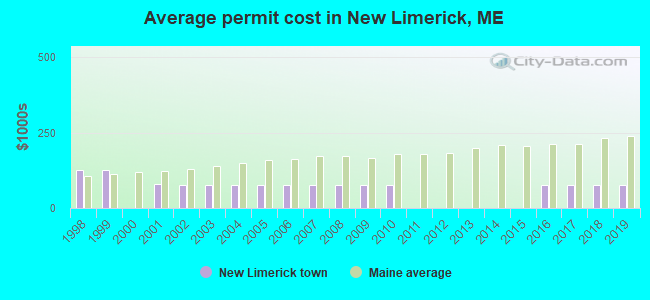
Single-family new house construction building permits:
- 2019: 2 buildings, average cost: $75,000
- 2018: 2 buildings, average cost: $75,000
- 2017: 2 buildings, average cost: $75,000
- 2016: 2 buildings, average cost: $75,000
- 2010: 2 buildings, average cost: $75,000
- 2009: 2 buildings, average cost: $75,000
- 2008: 2 buildings, average cost: $75,000
- 2007: 2 buildings, average cost: $75,000
- 2006: 2 buildings, average cost: $75,000
- 2005: 2 buildings, average cost: $75,000
- 2004: 2 buildings, average cost: $75,000
- 2003: 2 buildings, average cost: $75,000
- 2002: 3 buildings, average cost: $75,000
- 2001: 1 building, cost: $80,000
- 1999: 1 building, cost: $125,000
- 1998: 1 building, cost: $125,000
| Here: | 2.9% |
| Maine: | 3.4% |

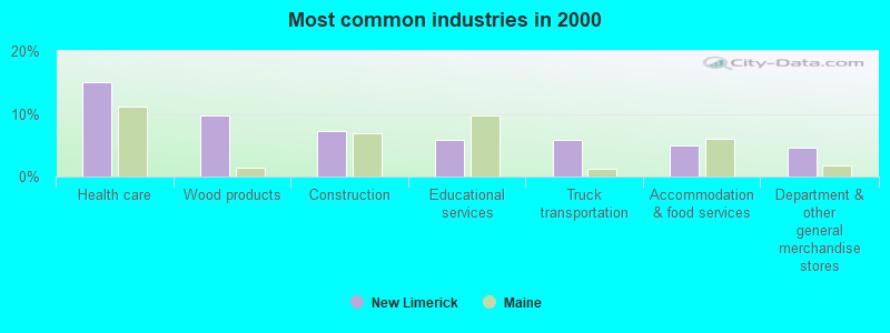
- Health care (15.1%)
- Wood products (9.7%)
- Construction (7.3%)
- Educational services (5.8%)
- Truck transportation (5.8%)
- Accommodation & food services (5.0%)
- Department & other general merchandise stores (4.6%)
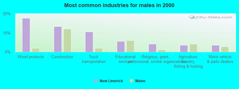
- Wood products (17.6%)
- Construction (13.4%)
- Truck transportation (10.6%)
- Educational services (5.6%)
- Religious, grantmaking, civic, professional, similar organizations (4.2%)
- Agriculture, forestry, fishing & hunting (3.5%)
- Motor vehicle & parts dealers (3.5%)

- Health care (30.8%)
- Department & other general merchandise stores (10.3%)
- Accommodation & food services (9.4%)
- Administrative & support & waste management services (6.0%)
- Educational services (6.0%)
- Apparel (4.3%)
- Social assistance (3.4%)

- Driver/sales workers and truck drivers (6.6%)
- Other office and administrative support workers, including supervisors (6.2%)
- Secretaries and administrative assistants (5.8%)
- Other management occupations, except farmers and farm managers (5.8%)
- Other sales and related occupations, including supervisors (5.0%)
- Retail sales workers, except cashiers (4.2%)
- Preschool, kindergarten, elementary, and middle school teachers (3.1%)

- Driver/sales workers and truck drivers (12.0%)
- Other management occupations, except farmers and farm managers (9.2%)
- Vehicle and mobile equipment mechanics, installers, and repairers (4.9%)
- Building and grounds cleaning and maintenance occupations (4.2%)
- Pipelayers, plumbers, pipefitters, and steamfitters (4.2%)
- Carpenters (3.5%)
- Electrical equipment mechanics and other installation, maintenance, and repair workers, including supervisors (3.5%)

- Secretaries and administrative assistants (12.8%)
- Other office and administrative support workers, including supervisors (10.3%)
- Retail sales workers, except cashiers (7.7%)
- Other sales and related occupations, including supervisors (7.7%)
- Therapists (6.0%)
- Nursing, psychiatric, and home health aides (6.0%)
- Preschool, kindergarten, elementary, and middle school teachers (4.3%)
Average climate in New Limerick, Maine
Based on data reported by over 4,000 weather stations


(lower is better)
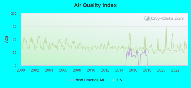
Air Quality Index (AQI) level in 2017 was 46.0. This is significantly better than average.
| City: | 46.0 |
| U.S.: | 72.6 |
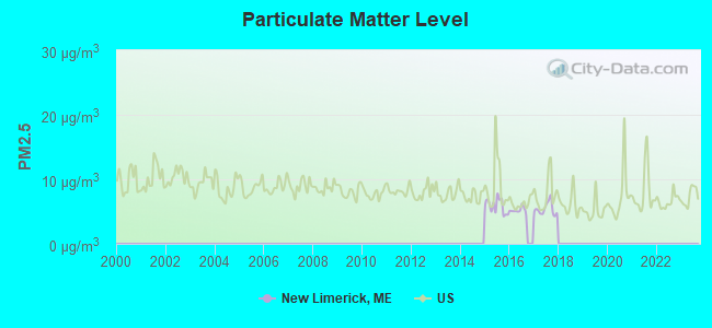
Particulate Matter (PM2.5) [µg/m3] level in 2017 was 5.39. This is significantly better than average. There were 0 monitors within city limits.
| City: | 5.39 |
| U.S.: | 8.11 |
Earthquake activity:
New Limerick-area historical earthquake activity is above Maine state average. It is 85% smaller than the overall U.S. average.On 4/20/2002 at 10:50:47, a magnitude 5.3 (5.3 ML, Depth: 3.0 mi, Class: Moderate, Intensity: VI - VII) earthquake occurred 299.3 miles away from the city center
On 4/20/2002 at 10:50:47, a magnitude 5.2 (5.2 MB, 4.2 MS, 5.2 MW, 5.0 MW) earthquake occurred 301.0 miles away from New Limerick center
On 10/16/2012 at 23:12:25, a magnitude 4.7 (4.7 ML, Depth: 10.0 mi, Class: Light, Intensity: IV - V) earthquake occurred 218.0 miles away from New Limerick center
On 7/14/2006 at 09:34:48, a magnitude 3.9 (3.9 MD, Depth: 8.6 mi, Class: Light, Intensity: II - III) earthquake occurred 62.6 miles away from New Limerick center
On 10/7/1983 at 10:18:46, a magnitude 5.3 (5.1 MB, 5.3 LG, 5.1 ML) earthquake occurred 344.9 miles away from the city center
On 1/19/1982 at 00:14:42, a magnitude 4.7 (4.5 MB, 4.7 MD, 4.5 LG) earthquake occurred 253.4 miles away from the city center
Magnitude types: regional Lg-wave magnitude (LG), body-wave magnitude (MB), duration magnitude (MD), local magnitude (ML), surface-wave magnitude (MS), moment magnitude (MW)
Natural disasters:
The number of natural disasters in Aroostook County (22) is greater than the US average (15).Major Disasters (Presidential) Declared: 13
Emergencies Declared: 9
Causes of natural disasters: Floods: 10, Storms: 8, Snows: 7, Heavy Rains: 2, Blizzard: 1, Hurricane: 1, Ice Storm: 1, Snowfall: 1, Snowstorm: 1, Wind: 1, Winter Storm: 1, Other: 2 (Note: some incidents may be assigned to more than one category).
Hospitals and medical centers near New Limerick:
- HOULTON REGIONAL HOSPITAL Critical Access Hospitals (about 7 miles away; HOULTON, ME)
- THE HOULTON REG PROG CARE FAC (Nursing Home, about 7 miles away; HOULTON, ME)
- HARMONY (Hospital, about 7 miles away; HOULTON, ME)
- FOREST SPRINGS (Hospital, about 7 miles away; HOULTON, ME)
- MADIGAN HOME HEALTH CARE, INC. (Home Health Center, about 8 miles away; HOULTON, ME)
- MADIGAN ESTATES (Nursing Home, about 8 miles away; HOULTON, ME)
Colleges/universities with over 2000 students nearest to New Limerick:
- University of Maine (about 91 miles; Orono, ME; Full-time enrollment: 8,931)
- Husson University (about 98 miles; Bangor, ME; FT enrollment: 2,421)
- University of Maine at Farmington (about 146 miles; Farmington, ME; FT enrollment: 2,036)
- University of Maine at Augusta (about 152 miles; Augusta, ME; FT enrollment: 3,204)
- Saint Joseph's College of Maine (about 201 miles; Standish, ME; FT enrollment: 2,010)
- Southern Maine Community College (about 204 miles; South Portland, ME; FT enrollment: 4,666)
- University of Southern Maine (about 204 miles; Portland, ME; FT enrollment: 6,647)
Points of interest:
Notable location: Houlton Community Golf Course (A). Display/hide its location on the map
Church in New Limerick: New Limerick Freewill Baptist Church (A). Display/hide its location on the map
Cemetery: New Limerick Cemetery (1). Display/hide its location on the map
Lakes and reservoirs: Bradbury Lake (A), Cochrane Lake (B), County Road Lake (C), Glancy Lake (D), Gould Pond (E), Green Pond (F), Hannigan Pond (G), Nickerson Lake (H). Display/hide their locations on the map
Streams, rivers, and creeks: Mill Brook (A), Lamb Brook (B), Baxter Brook (C). Display/hide their locations on the map
| This town: | 2.1 people |
| Maine: | 2.3 people |
| This town: | 63.9% |
| Whole state: | 62.9% |
| This town: | 6.6% |
| Whole state: | 9.4% |
No gay or lesbian households reported
| This town: | 10.4% |
| Whole state: | 10.9% |
| This town: | 1.3% |
| Whole state: | 4.1% |
For population 15 years and over in New Limerick:
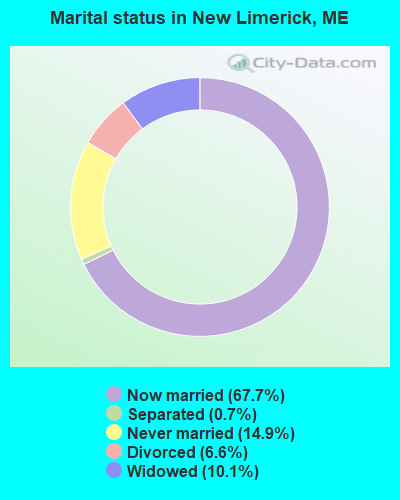
- Never married: 14.9%
- Now married: 67.7%
- Separated: 0.7%
- Widowed: 10.1%
- Divorced: 6.6%
For population 25 years and over in New Limerick:
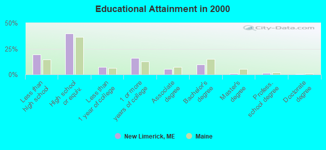
- High school or higher: 80.4%
- Bachelor's degree or higher: 12.1%
- Graduate or professional degree: 2.6%
- Unemployed: 0.8%
- Mean travel time to work (commute): 20.3 minutes

| Here: | 10.8 |
| Maine average: | 11.2 |


Graphs represent county-level data. Detailed 2008 Election Results
Religion statistics for New Limerick, ME (based on Aroostook County data)


| Religion | Adherents | Congregations |
|---|---|---|
| Catholic | 22,200 | 27 |
| Mainline Protestant | 5,845 | 40 |
| Evangelical Protestant | 4,411 | 51 |
| Other | 957 | 7 |
| Orthodox | 10 | 1 |
| None | 38,447 | - |
Food Environment Statistics:
| Aroostook County: | 4.03 / 10,000 pop. |
| Maine: | 2.80 / 10,000 pop. |
| This county: | 0.14 / 10,000 pop. |
| Maine: | 0.14 / 10,000 pop. |
| This county: | 2.22 / 10,000 pop. |
| State: | 2.20 / 10,000 pop. |
| Aroostook County: | 7.78 / 10,000 pop. |
| Maine: | 5.75 / 10,000 pop. |
| Aroostook County: | 9.17 / 10,000 pop. |
| State: | 11.02 / 10,000 pop. |
| Aroostook County: | 11.7% |
| State: | 8.2% |
| Aroostook County: | 27.6% |
| Maine: | 25.0% |
Strongest AM radio stations in New Limerick:
- WREM (710 AM; daytime; 5 kW; MONTICELLO, ME; Owner: ALLAN H WEINER)
- WFST (600 AM; 5 kW; CARIBOU, ME; Owner: NORTHERN BROADCAST MINISTRIES, INC.)
- WEGP (1390 AM; 5 kW; PRESQUE ISLE, ME; Owner: DECELLES/SMITH MEDIA, INC.)
- WZON (620 AM; 5 kW; BANGOR, ME; Owner: THE ZONE CORPORATION)
- WRKO (680 AM; 50 kW; BOSTON, MA; Owner: ENTERCOM BOSTON LICENSE, LLC)
- WEEI (850 AM; 50 kW; BOSTON, MA; Owner: ENTERCOM BOSTON LICENSE, LLC)
- WCHP (760 AM; 35 kW; CHAMPLAIN, NY; Owner: CHAMPLAIN RADIO, INC.)
- WNNZ (640 AM; 50 kW; WESTFIELD, MA; Owner: CLEAR CHANNEL BROADCASTING LICENSES, INC.)
- WABI (910 AM; 5 kW; BANGOR, ME; Owner: CLEAR CHANNEL BROADCASTING LICENSES, INC.)
- WSKW (1160 AM; 10 kW; SKOWHEGAN, ME; Owner: MOUNTAIN WIRELESS, INCORPORATED)
- WCRN (830 AM; 50 kW; WORCESTER, MA; Owner: CARTER BROADCASTING CORPORATION)
- WBZ (1030 AM; 50 kW; BOSTON, MA; Owner: INFINITY BROADCASTING OPERATIONS, INC.)
- WTME (780 AM; 10 kW; RUMFORD, ME; Owner: MOUNTAIN VALLEY BROADCASTING, INC.)
Strongest FM radio stations in New Limerick:
- WHOU-FM (100.1 FM; HOULTON, ME; Owner: COUNTY COMMUNICATIONS, INC.)
- WQHR (96.1 FM; PRESQUE ISLE, ME; Owner: CITADEL BROADCASTING COMPANY)
- WOZI (101.9 FM; PRESQUE ISLE, ME; Owner: CITADEL BROADCASTING COMPANY)
- WMEM (106.1 FM; PRESQUE ISLE, ME; Owner: MAINE PUBLIC BROADCASTING CORPORATION)
- WBPW (96.9 FM; PRESQUE ISLE, ME; Owner: CITADEL BROADCASTING COMPANY)
New Limerick fatal accident list:
Aug 15, 2020 09:56 AM, Sr-Drews Lake Rd, Lat: 46.100864, Lon: -67.907481, Vehicles: 1, Persons: 1, Fatalities: 1
Sep 19, 2010 07:28 PM, Us-2, Lat: 46.125606, Lon: -67.939625, Vehicles: 1, Persons: 3, Fatalities: 1
Jan 25, 1995 01:25 PM, 2, Vehicles: 2, Persons: 2, Fatalities: 1
- National Bridge Inventory (NBI) Statistics
- 4Number of bridges
- 10ft / 3.5mTotal length
- 4,770Total average daily traffic
- 238Total average daily truck traffic
- 7,239Total future (year 2036) average daily traffic
FCC Registered Amateur Radio Licenses:
12 (See the full list of FCC Registered Amateur Radio Licenses in New Limerick)FAA Registered Aircraft:
1- Aircraft: PIPER PA-24 (Category: Land, Seats: 4, Weight: Up to 12,499 Pounds, Speed: 120 mph), Engine: LYCOMING O&VO-360 SER (180 HP) (Reciprocating)
N-Number: 5078P, N5078P, N-5078P, Serial Number: 24-84, Year manufactured: 1958, Airworthiness Date: 03/26/1958, Certificate Issue Date: 04/30/2019
Registrant (Individual): Andrew L Putnam, 337 Drews Lake Rd, New Limerick, ME 04761
New Limerick compared to Maine state average:
- Median house value below state average.
- Unemployed percentage significantly below state average.
- Black race population percentage significantly below state average.
- Hispanic race population percentage significantly below state average.
- Median age significantly above state average.
- Renting percentage below state average.
- Length of stay since moving in significantly above state average.
- Number of rooms per house significantly below state average.
- House age significantly below state average.
- Number of college students below state average.
- Percentage of population with a bachelor's degree or higher below state average.

|
Total of 6 patent applications in 2008-2024.