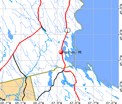
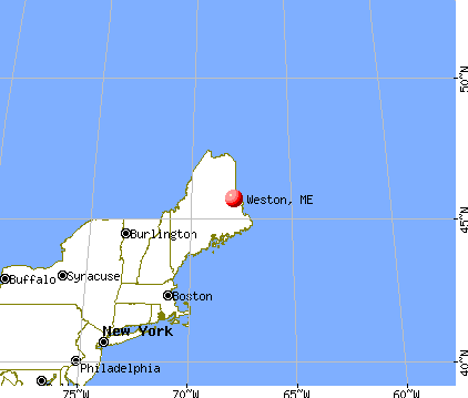
Weston, Maine


Submit your own pictures of this town and show them to the world
- OSM Map
- General Map
- Google Map
- MSN Map
Population change since 2000: +12.3%
 |
| Males: 124 | |
| Females: 104 |
| Median resident age: | 51.6 years |
| Maine median age: | 43.0 years |
Zip codes: 04424.
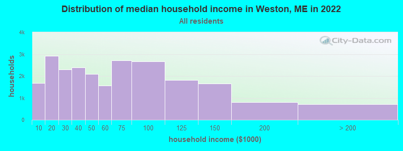
| Weston: | $38,192 |
| ME: | $69,543 |
Estimated per capita income in 2022: $23,719 (it was $11,493 in 2000)
Weston town income, earnings, and wages data
Estimated median house or condo value in 2022: $164,886 (it was $68,100 in 2000)
| Weston: | $164,886 |
| ME: | $290,600 |
Mean prices in 2022: all housing units: $179,108; detached houses: $185,023; townhouses or other attached units: $218,327; in 2-unit structures: $262,505; in 3-to-4-unit structures: $121,406; in 5-or-more-unit structures: $185,084; mobile homes: $117,009; occupied boats, rvs, vans, etc.: $12,682
Detailed information about poverty and poor residents in Weston, ME
Compare current foreclosures near your location:
| Photo | Address | Area | Beds / Baths | Price | Details |
|---|---|---|---|---|---|

|
#1
E 21st Ave
Columbus, OH 43211
|
1,061 sq. feet
|
1 baths 3 beds |
$179,900
|
show details |

|
#2
S High St
Columbus, OH 43207
|
1,678 sq. feet
|
2 baths 4 beds |
$31,900
|
show details |

|
#3
Bayberry Cir
Columbus, OH 43207
|
1,564 sq. feet
|
1 baths 3 beds |
$127,500
|
show details |

|
#4
Armada Rd
Columbus, OH 43232
|
1,028 sq. feet
|
1 baths 4 beds |
show details | |

|
#5
Grasmere Ave
Columbus, OH 43211
|
720 sq. feet
|
1 baths 2 beds |
show details | |

|
#6
Safford Ave
Columbus, OH 43223
|
784 sq. feet
|
1 baths 2 beds |
show details | |

|
#7
Scottwood Rd
Columbus, OH 43227
|
1,008 sq. feet
|
1 baths 3 beds |
show details | |

|
#8
Summertree Ln
Westerville, OH 43081
|
2,496 sq. feet
|
2 baths 3 beds |
show details | |

|
#9
Derrer Rd -872
Columbus, OH 43204
|
1,667 sq. feet
|
2 baths 5 beds |
show details | |

|
#10
Wrexham Ave
Columbus, OH 43223
|
1,235 sq. feet
|
1 baths 3 beds |
show details |
| Photo | Address | Area | Beds / Baths | Price | Details |
|---|---|---|---|---|---|

|
#11
Lehner Rd
Columbus, OH 43224
|
1,628 sq. feet
|
2 baths 4 beds |
show details | |

|
#12
Fahlander Dr N
Columbus, OH 43229
|
1,338 sq. feet
|
2 baths 3 beds |
show details | |

|
#13
High Free Pike
West Jefferson, OH 43162
|
1,216 sq. feet
|
2 baths 4 beds |
show details | |

|
#14
S Richardson Ave
Columbus, OH 43204
|
1,520 sq. feet
|
2 baths 3 beds |
show details | |

|
#15
Brookstone Dr
Westerville, OH 43082
|
1,783 sq. feet
|
3 baths 3 beds |
show details | |

|
#16
E Howard Rd
Columbus, OH 43207
|
1,056 sq. feet
|
1 baths 3 beds |
show details | |

|
#17
Midland Ave
Columbus, OH 43223
|
1,518 sq. feet
|
1 baths 2 beds |
show details | |

|
#18
Marshrun Dr
Grove City, OH 43123
|
2,036 sq. feet
|
2 baths 4 beds |
show details | |

|
#19
N Roys Ave
Columbus, OH 43204
|
1,248 sq. feet
|
2 baths 3 beds |
show details | |

|
#20
Meadowbrook Dr
Columbus, OH 43207
|
1,752 sq. feet
|
2 baths 4 beds |
show details |
| Photo | Address | Area | Beds / Baths | Price | Details |
|---|---|---|---|---|---|

|
#21
Stoneybrook Blvd # 21a
Hilliard, OH 43026
|
1,231 sq. feet
|
2 baths 3 beds |
show details | |

|
#22
Mink St SW
Pataskala, OH 43062
|
1,442 sq. feet
|
1 baths 3 beds |
show details | |

|
#23
London Groveport Rd
Grove City, OH 43123
|
816 sq. feet
|
1 baths 2 beds |
show details | |

|
#24
Glenmate Ct
Columbus, OH 43223
|
1,050 sq. feet
|
1 baths 3 beds |
show details | |

|
#25
Gladys Rd
Columbus, OH 43228
|
832 sq. feet
|
1 baths 3 beds |
show details | |

|
#26
Striebel Ct
Columbus, OH 43227
|
925 sq. feet
|
1 baths 3 beds |
show details | |

|
#27
N 18th St
Columbus, OH 43203
|
1,690 sq. feet
|
1 baths 4 beds |
show details | |

|
#28
Fergus Rd
Grove City, OH 43123
|
3,312 sq. feet
|
2 baths 4 beds |
show details | |

|
#29
Chester Rd
Columbus, OH 43221
|
3,300 sq. feet
|
4 baths 5 beds |
show details | |

|
#30
Sleeping Meadow Dr
New Albany, OH 43054
|
3,211 sq. feet
|
2 baths 4 beds |
show details |
| Photo | Address | Area | Beds / Baths | Price | Details |
|---|---|---|---|---|---|

|
#31
E Welch Ave
Columbus, OH 43207
|
1,864 sq. feet
|
2 baths 4 beds |
show details | |

|
#32
Kingsglen Dr
Grove City, OH 43123
|
1,635 sq. feet
|
2 baths 4 beds |
show details | |

|
#33
S Hague Ave
Columbus, OH 43204
|
979 sq. feet
|
1 baths 2 beds |
show details | |

|
#34
Ashgrove Dr
Grove City, OH 43123
|
1,772 sq. feet
|
2 baths 4 beds |
show details | |

|
#35
Chidley St
Galloway, OH 43119
|
1,502 sq. feet
|
1 baths 3 beds |
show details | |

|
#36
Hildreth Ave
Columbus, OH 43203
|
1,798 sq. feet
|
2 baths 4 beds |
show details | |

|
#37
Fairfield Ave
Columbus, OH 43203
|
984 sq. feet
|
1 baths 2 beds |
show details | |

|
#38
Ratify Blvd
Columbus, OH 43207
|
1,356 sq. feet
|
2 baths 3 beds |
show details | |

|
#39
Andrus Ave
Columbus, OH 43227
|
1,264 sq. feet
|
1 baths 3 beds |
show details | |

|
#40
Berrywood Dr
Columbus, OH 43220
|
1,182 sq. feet
|
1 baths 2 beds |
show details |
| Photo | Address | Area | Beds / Baths | Price | Details |
|---|---|---|---|---|---|

|
#41
Simpson Dr
Columbus, OH 43227
|
1,104 sq. feet
|
1 baths 3 beds |
show details | |

|
#42
Nantucket Ave
Columbus, OH 43235
|
1,864 sq. feet
|
2 baths 3 beds |
show details | |

|
#43
Bostwick Rd
Columbus, OH 43227
|
1,284 sq. feet
|
1 baths 4 beds |
show details | |

|
#44
Messner Dr
Hilliard, OH 43026
|
832 sq. feet
|
1 baths 2 beds |
show details | |

|
#45
Camhurst Ct
Galloway, OH 43119
|
1,969 sq. feet
|
2 baths 3 beds |
show details | |

|
#46
Illinois Ave
Westerville, OH 43081
|
1,120 sq. feet
|
1 baths 3 beds |
show details | |

|
#47
Renford Ct
Powell, OH 43065
|
1,795 sq. feet
|
1 baths 3 beds |
show details | |

|
#48
Casa Blvd
Grove City, OH 43123
|
1,002 sq. feet
|
1 baths 2 beds |
show details | |

|
#49
Mango Ln
Hilliard, OH 43026
|
1,024 sq. feet
|
1 baths 2 beds |
show details | |

|
Check over 1 million property listings on Foreclosure.com!
|
browse all offers | |||

- 21694.7%White alone
- 41.8%Hispanic
- 31.3%Two or more races
- 20.9%American Indian alone
- 20.9%Asian alone
- 10.4%Black alone
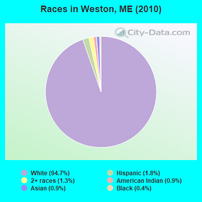
Races in Weston detailed stats: ancestries, foreign born residents, place of birth
 Recent articles from our blog. Our writers, many of them Ph.D. graduates or candidates, create easy-to-read articles on a wide variety of topics.

 | portland, me vs. burlington, vt (16 replies) |
| A few pictures form the drive to Houlton Sunday. (3 replies) |
| So what is wrong with white bread?? (67 replies) |
| Maine Deer hunting update (231 replies) |
| Deep Thoughts (1103 replies) |
| Quick help for tomorrow please if you can? (15 replies) |
Latest news from Weston, ME collected exclusively by city-data.com from local newspapers, TV, and radio stations
Ancestries: English (25.1%), Irish (13.3%), Scottish (13.3%), German (10.8%), French (8.9%), Dutch (3.4%).
Current Local Time: EST time zone
Incorporated on 03/17/1835
Elevation: 717 feet
Land area: 30.5 square miles.
Population density: 7.5 people per square mile (very low).
10 residents are foreign born (3.0% North America, 2.0% Latin America).
| This town: | 4.9% |
| Maine: | 2.9% |
| Weston town: | 0.8% ($527) |
| Maine: | 1.5% ($1,417) |
Nearest city with pop. 50,000+: Portland, ME  (185.6 miles , pop. 64,249).
Nearest city with pop. 200,000+: Boston, MA (285.3 miles , pop. 589,141).
Nearest city with pop. 1,000,000+: Bronx, NY (453.3 miles , pop. 1,332,650).
Nearest cities:
), ), Latitude: 45.74 N, Longitude: 67.87 W
Area code commonly used in this area: 207

| Here: | 2.6% |
| Maine: | 3.4% |

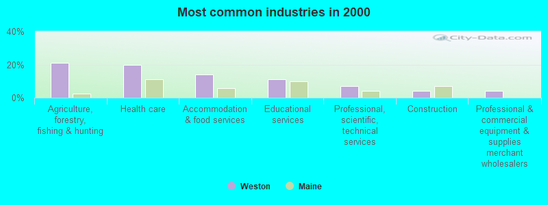
- Agriculture, forestry, fishing & hunting (21.1%)
- Health care (19.7%)
- Accommodation & food services (14.1%)
- Educational services (11.3%)
- Professional, scientific, technical services (7.0%)
- Construction (4.2%)
- Professional & commercial equipment & supplies merchant wholesalers (4.2%)

- Agriculture, forestry, fishing & hunting (40.5%)
- Professional, scientific, technical services (13.5%)
- Wood products (8.1%)
- Construction (8.1%)
- Professional & commercial equipment & supplies merchant wholesalers (8.1%)
- Truck transportation (5.4%)
- Administrative & support & waste management services (5.4%)

- Health care (41.2%)
- Accommodation & food services (26.5%)
- Educational services (17.6%)
- Department & other general merchandise stores (5.9%)
- Pharmacies & drug stores (5.9%)
- Social assistance (2.9%)
- Textile mills & textile products (0.0%)

- Driver/sales workers and truck drivers (12.7%)
- Other management occupations, except farmers and farm managers (11.3%)
- Electrical equipment mechanics and other installation, maintenance, and repair workers, including supervisors (8.5%)
- Cooks and food preparation workers (7.0%)
- Vehicle and mobile equipment mechanics, installers, and repairers (7.0%)
- Other production occupations, including supervisors (7.0%)
- Nursing, psychiatric, and home health aides (5.6%)

- Driver/sales workers and truck drivers (24.3%)
- Electrical equipment mechanics and other installation, maintenance, and repair workers, including supervisors (16.2%)
- Vehicle and mobile equipment mechanics, installers, and repairers (13.5%)
- Other production occupations, including supervisors (13.5%)
- Other management occupations, except farmers and farm managers (10.8%)
- Fishing, hunting, and forestry occupations (8.1%)
- Life and physical scientists (5.4%)

- Cooks and food preparation workers (14.7%)
- Nursing, psychiatric, and home health aides (11.8%)
- Other management occupations, except farmers and farm managers (11.8%)
- Secretaries and administrative assistants (11.8%)
- Preschool, kindergarten, elementary, and middle school teachers (8.8%)
- Building and grounds cleaning and maintenance occupations (8.8%)
- Counselors, social workers, and other community and social service specialists (5.9%)
Average climate in Weston, Maine
Based on data reported by over 4,000 weather stations


Earthquake activity:
Weston-area historical earthquake activity is above Maine state average. It is 85% smaller than the overall U.S. average.On 4/20/2002 at 10:50:47, a magnitude 5.3 (5.3 ML, Depth: 3.0 mi, Class: Moderate, Intensity: VI - VII) earthquake occurred 296.6 miles away from the city center
On 10/16/2012 at 23:12:25, a magnitude 4.7 (4.7 ML, Depth: 10.0 mi, Class: Light, Intensity: IV - V) earthquake occurred 201.7 miles away from Weston center
On 4/20/2002 at 10:50:47, a magnitude 5.2 (5.2 MB, 4.2 MS, 5.2 MW, 5.0 MW) earthquake occurred 298.1 miles away from the city center
On 10/7/1983 at 10:18:46, a magnitude 5.3 (5.1 MB, 5.3 LG, 5.1 ML) earthquake occurred 340.4 miles away from Weston center
On 1/19/1982 at 00:14:42, a magnitude 4.7 (4.5 MB, 4.7 MD, 4.5 LG) earthquake occurred 240.1 miles away from the city center
On 7/14/2006 at 09:34:48, a magnitude 3.9 (3.9 MD, Depth: 8.6 mi, Class: Light, Intensity: II - III) earthquake occurred 87.8 miles away from Weston center
Magnitude types: regional Lg-wave magnitude (LG), body-wave magnitude (MB), duration magnitude (MD), local magnitude (ML), surface-wave magnitude (MS), moment magnitude (MW)
Natural disasters:
The number of natural disasters in Aroostook County (22) is greater than the US average (15).Major Disasters (Presidential) Declared: 13
Emergencies Declared: 9
Causes of natural disasters: Floods: 10, Storms: 8, Snows: 7, Heavy Rains: 2, Blizzard: 1, Hurricane: 1, Ice Storm: 1, Snowfall: 1, Snowstorm: 1, Wind: 1, Winter Storm: 1, Other: 2 (Note: some incidents may be assigned to more than one category).
Colleges/universities with over 2000 students nearest to Weston:
- University of Maine (about 71 miles; Orono, ME; Full-time enrollment: 8,931)
- Husson University (about 78 miles; Bangor, ME; FT enrollment: 2,421)
- University of Maine at Farmington (about 134 miles; Farmington, ME; FT enrollment: 2,036)
- University of Maine at Augusta (about 136 miles; Augusta, ME; FT enrollment: 3,204)
- Saint Joseph's College of Maine (about 185 miles; Standish, ME; FT enrollment: 2,010)
- Southern Maine Community College (about 186 miles; South Portland, ME; FT enrollment: 4,666)
- University of Southern Maine (about 186 miles; Portland, ME; FT enrollment: 6,647)
Points of interest:
Notable locations in Weston: Grand Lake Grange (A), Dark Cove (B). Display/hide their locations on the map
Church in Weston: Weston Community Church (A). Display/hide its location on the map
Cemeteries: Butterfield Cemetery (1), Brackett Cemetery (2), Selden Cemetery (3), Trout Brook Cemetery (4). Display/hide their locations on the map
Lakes: Grand Lake (A), Brackett Lake (B), Dingey Pond (C), Faulkner Lake (D), Longfellow Lake (E). Display/hide their locations on the map
Streams, rivers, and creeks: Deering Brook (A). Display/hide its location on the map
Drinking water stations with addresses in Weston and their reported violations in the past:
RIDEOUTS LODGE AND COTTAGES LLC (Population served: 60, Groundwater):Past monitoring violations:
- 3 routine major monitoring violations
- One regular monitoring violation
| This town: | 2.0 people |
| Maine: | 2.3 people |
| This town: | 60.7% |
| Whole state: | 62.9% |
| This town: | 6.2% |
| Whole state: | 9.4% |
No gay or lesbian households reported
| This town: | 34.5% |
| Whole state: | 10.9% |
| This town: | 5.1% |
| Whole state: | 4.1% |
For population 15 years and over in Weston:
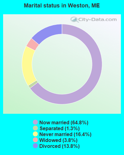
- Never married: 16.4%
- Now married: 64.8%
- Separated: 1.3%
- Widowed: 3.8%
- Divorced: 13.8%
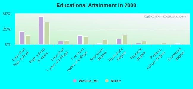
For population 25 years and over in Weston:
- High school or higher: 79.3%
- Bachelor's degree or higher: 12.4%
- Graduate or professional degree: 3.4%
- Unemployed: 12.3%
- Mean travel time to work (commute): 23.4 minutes

| Here: | 10.2 |
| Maine average: | 11.2 |


Graphs represent county-level data. Detailed 2008 Election Results
Religion statistics for Weston, ME (based on Aroostook County data)


| Religion | Adherents | Congregations |
|---|---|---|
| Catholic | 22,200 | 27 |
| Mainline Protestant | 5,845 | 40 |
| Evangelical Protestant | 4,411 | 51 |
| Other | 957 | 7 |
| Orthodox | 10 | 1 |
| None | 38,447 | - |
Food Environment Statistics:
| Here: | 4.03 / 10,000 pop. |
| Maine: | 2.80 / 10,000 pop. |
| Aroostook County: | 0.14 / 10,000 pop. |
| Maine: | 0.14 / 10,000 pop. |
| Aroostook County: | 2.22 / 10,000 pop. |
| Maine: | 2.20 / 10,000 pop. |
| Aroostook County: | 7.78 / 10,000 pop. |
| State: | 5.75 / 10,000 pop. |
| This county: | 9.17 / 10,000 pop. |
| Maine: | 11.02 / 10,000 pop. |
| Aroostook County: | 11.7% |
| Maine: | 8.2% |
| This county: | 27.6% |
| Maine: | 25.0% |
Strongest AM radio stations in Weston:
- WREM (710 AM; daytime; 5 kW; MONTICELLO, ME; Owner: ALLAN H WEINER)
- WZON (620 AM; 5 kW; BANGOR, ME; Owner: THE ZONE CORPORATION)
- WFST (600 AM; 5 kW; CARIBOU, ME; Owner: NORTHERN BROADCAST MINISTRIES, INC.)
- WRKO (680 AM; 50 kW; BOSTON, MA; Owner: ENTERCOM BOSTON LICENSE, LLC)
- WEGP (1390 AM; 5 kW; PRESQUE ISLE, ME; Owner: DECELLES/SMITH MEDIA, INC.)
- WABI (910 AM; 5 kW; BANGOR, ME; Owner: CLEAR CHANNEL BROADCASTING LICENSES, INC.)
- WSKW (1160 AM; 10 kW; SKOWHEGAN, ME; Owner: MOUNTAIN WIRELESS, INCORPORATED)
- WEEI (850 AM; 50 kW; BOSTON, MA; Owner: ENTERCOM BOSTON LICENSE, LLC)
- WNNZ (640 AM; 50 kW; WESTFIELD, MA; Owner: CLEAR CHANNEL BROADCASTING LICENSES, INC.)
- WBZ (1030 AM; 50 kW; BOSTON, MA; Owner: INFINITY BROADCASTING OPERATIONS, INC.)
- WCRN (830 AM; 50 kW; WORCESTER, MA; Owner: CARTER BROADCASTING CORPORATION)
- WCHP (760 AM; 35 kW; CHAMPLAIN, NY; Owner: CHAMPLAIN RADIO, INC.)
- WTME (780 AM; 10 kW; RUMFORD, ME; Owner: MOUNTAIN VALLEY BROADCASTING, INC.)
Strongest FM radio stations in Weston:
- WHCF (88.5 FM; BANGOR, ME; Owner: BANGOR BAPTIST CHURCH)
- WVOM (103.9 FM; HOWLAND, ME; Owner: CLEAR CHANNEL BROADCASTING LICENSES, INC.)
- WHOU-FM (100.1 FM; HOULTON, ME; Owner: COUNTY COMMUNICATIONS, INC.)
TV broadcast stations around Weston:
- W17BJ (Channel 17; DANFORTH, ME; Owner: TRINITY BROADCASTING NETWORK)
Weston fatal accident list:
Apr 24, 1989 07:25 PM, 60046005, Vehicles: 1, Persons: 3, Fatalities: 1
FCC Registered Broadcast Land Mobile Towers:
3- WESTON BIDP, Partridge Ln (Lat: 45.689639 Lon: -67.854722), Type: Mtower, Structure height: 36.5 m, Overall height: 42.5 m, Call Sign: WGP684,
Assigned Frequencies: 154.280 MHz, 154.310 MHz, Grant Date: 08/03/2011, Expiration Date: 07/10/2021, Cancellation Date: 10/16/2021, Registrant: Pct Communications, 483 North St, Calais, ME 04619, Phone: (207) 454-2174, Fax: (207) 454-7050, Email:
- Partridge Lane (Lat: 45.689639 Lon: -67.854722), Type: Tower, Structure height: 36.6 m, Overall height: 42.6 m, Call Sign: WQLR821,
Assigned Frequencies: 4980.00 MHz, Grant Date: 03/11/2020, Expiration Date: 04/09/2030, Certifier: Larry Hayward, Registrant: Pct Communications, Calais, ME 04619, Phone: (207) 454-2174, Fax: (207) 454-7050, Email:
- WESTON BIDP, Partridge Ln (Lat: 45.689639 Lon: -67.854722), Type: Mtower, Structure height: 36.5 m, Overall height: 42.5 m, Call Sign: WRTY686,
Assigned Frequencies: 154.310 MHz, Grant Date: 07/29/2022, Expiration Date: 07/29/2032, Certifier: Josh Rolfe, Registrant: Pct Communications, 483 North St, Calais, ME 04619, Phone: (207) 454-2174, Fax: (207) 454-7050, Email:
Weston compared to Maine state average:
- Median household income below state average.
- Median house value below state average.
- Black race population percentage significantly below state average.
- Median age significantly above state average.
- Renting percentage significantly below state average.
- Length of stay since moving in significantly above state average.
- Number of rooms per house significantly below state average.
- House age significantly below state average.
- Number of college students significantly below state average.
- Percentage of population with a bachelor's degree or higher below state average.