Bridge Statistics for West Seneca, New York (NY)
Condition, Traffic, Stress, Structural Evaluation, Project Costs
- National Bridge Inventory (NBI) Statistics
- 92Number of bridges
- 1,168ft / 356mTotal length
- $453,965,000Total costs
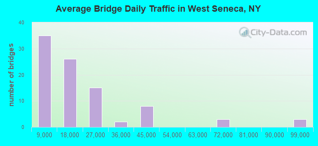
- 1,734,757Total average daily traffic
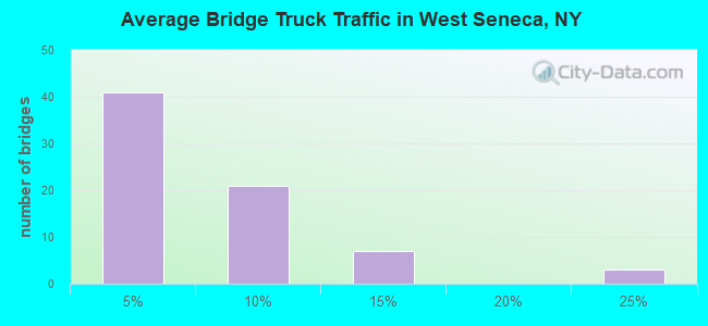
- 96,771Total average daily truck traffic
- National Bridge Inventory (NBI) Registered Bridges for West Seneca
- No street view available for this location
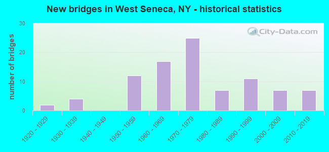
- New bridges - historical statistics
- 21920-1929
- 41930-1939
- 121950-1959
- 171960-1969
- 251970-1979
- 71980-1989
- 111990-1999
- 72000-2009
- 72010-2019
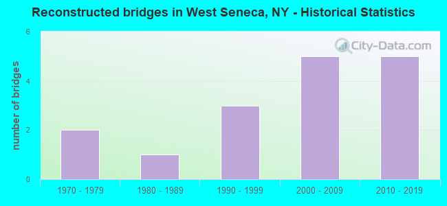
- Reconstructed bridges - Historical Statistics
- 21970-1979
- 11980-1989
- 31990-1999
- 52000-2009
- 52010-2019
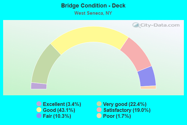
- Bridge Condition - Deck
- 3.4%Excellent
- 22.4%Very good
- 43.1%Good
- 19.0%Satisfactory
- 10.3%Fair
- 1.7%Poor
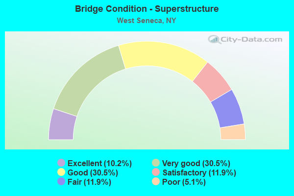
- Bridge Condition - Superstructure
- 10.2%Excellent
- 30.5%Very good
- 30.5%Good
- 11.9%Satisfactory
- 11.9%Fair
- 5.1%Poor
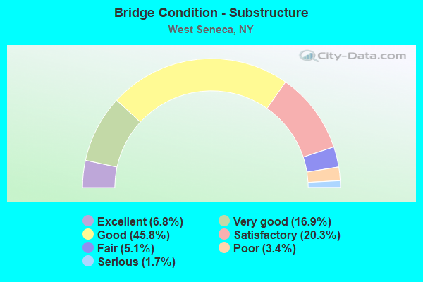
- Bridge Condition - Substructure
- 6.8%Excellent
- 16.9%Very good
- 45.8%Good
- 20.3%Satisfactory
- 5.1%Fair
- 3.4%Poor
- 1.7%Serious
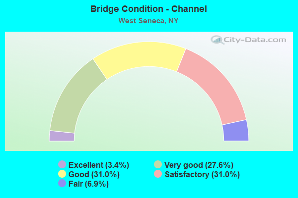
- Bridge Condition - Channel
- 3.4%Excellent
- 27.6%Very good
- 31.0%Good
- 31.0%Satisfactory
- 6.9%Fair
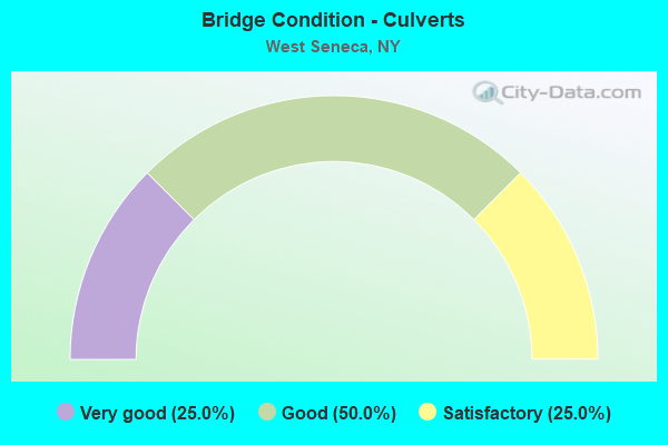
- Bridge Condition - Culverts
- 25.0%Very good
- 50.0%Good
- 25.0%Satisfactory
Find on map >> Show street view
Structure Number: 5512089, Location: 1.3 MI S JCT I90 & SH 354 (Lat: 42.864619, Lng: -78.791628), Route carried "under" structure: County highway , Year Built: 2002, Structure Length: 0. m, Average Daily Traffic: 5,738 (year 2019), Truck Traffic: 2%, Features Intersected: MINERAL SPRINGS RD, Facility Carried by Structure: RTE I90
Minimum Vertical Clearance: 4.55m (14.93ft), Kilometerpoint: 0.000, Lanes on structure: 8, Lanes under structure: 2, Material/Design: Steel, Design/Construction: Stringer/Multi-beam, Length of Maximum Span: 36.6m (120.1ft)
Find on map >> Show street view
Structure Number: 5512099, Location: 1.0 MI N JCT I90(Lat: 42.854619, Lng: -78.790836), Route carried "under" structure: County highway , Year Built: 1956, Structure Length: 0. m, Average Daily Traffic: 4,442 (year 2020), Truck Traffic: 5%, Features Intersected: INDIAN CHURCH RD, NORFOL, Facility Carried by Structure: RTE I90
Minimum Vertical Clearance: 6.88m (22.57ft), Kilometerpoint: 0.000, Lanes on structure: 9, Lanes under structure: 2, Material/Design: Steel continuous, Design/Construction: Stringer/Multi-beam, Length of Maximum Span: 27.4m (89.9ft)
Structure Number: 5512099, Location: 1.0 MI N JCT I90
Minimum Vertical Clearance: 6.88m (22.57ft), Kilometerpoint: 0.000, Lanes on structure: 9, Lanes under structure: 2, Material/Design: Steel continuous, Design/Construction: Stringer/Multi-beam, Length of Maximum Span: 27.4m (89.9ft)
Find on map >> Show street view
Structure Number: 5512109, Location: JCT OF RTS I90 AND 400 (Lat: 42.849822, Lng: -78.790281), Route carried "under" structure: Interstate 90, Year Built: 1998, Structure Length: 0. m, Average Daily Traffic: 40,200 (year 1970), Features Intersected: 90IX, RTE I90, Facility Carried by Structure: NY Route 400 Ramp
Minimum Vertical Clearance: 5.03m (16.50ft), Kilometerpoint: 688.555, Lanes on structure: 3, Lanes under structure: 4, Material/Design: Steel continuous, Design/Construction: Stringer/Multi-beam, Length of Maximum Span: 32.3m (106.0ft)
Find on map >> Show street view
Structure Number: 70155, Location: .3 MI W JCT US 20 & US219 (Lat: 42.781872, Lng: -78.778553), Route carried "under" structure: US 20, Year Built: 1995, Structure Length: 0. m, Average Daily Traffic: 17,180 (year 2000), Features Intersected: RTE 20, Facility Carried by Structure: BUFF & PITTSBURGH
Minimum Vertical Clearance: 4.85m (15.91ft), Kilometerpoint: 36.363, Lanes under structure: 5, Material/Design: Steel, Design/Construction: Girder and Floorbeam System, Length of Maximum Span: 35.9m (117.8ft)
Find on map >> Show street view
Structure Number: 701553, Location: 0.75 MI N JCT RTS 20 + 16 (Lat: 42.838381, Lng: -78.696892), Route carried "under" structure: State highway 78, Year Built: 2000, Structure Length: 0. m, Average Daily Traffic: 23,940 (year 1999), Features Intersected: RTE 78, Facility Carried by Structure: NORFOLK SOUTHERN
Minimum Vertical Clearance: 4.57m (14.99ft), Kilometerpoint: 26.211, Lanes under structure: 5, Material/Design: Steel, Design/Construction: Girder and Floorbeam System, Length of Maximum Span: 32.8m (107.6ft)
Find on map >> Show street view
Structure Number: 770854, Location: 0.9 MI NW JCT RTS 400&20 (Lat: 42.839822, Lng: -78.711592), Route carried "under" structure: County highway , Year Built: 1974, Structure Length: 0. m, Average Daily Traffic: 7,400 (year 1977), Features Intersected: LEIN ROAD-C R 154, Facility Carried by Structure: NORFOLK SOUTHERN
Minimum Vertical Clearance: 4.36m (14.30ft), Kilometerpoint: 0.644, Lanes under structure: 2, Material/Design: Steel, Design/Construction: Girder and Floorbeam System, Length of Maximum Span: 16.7m (54.8ft)