Bridge Statistics for West Seneca, New York (NY)
Condition, Traffic, Stress, Structural Evaluation, Project Costs
- National Bridge Inventory (NBI) Statistics
- 92Number of bridges
- 1,168ft / 356mTotal length
- $453,965,000Total costs
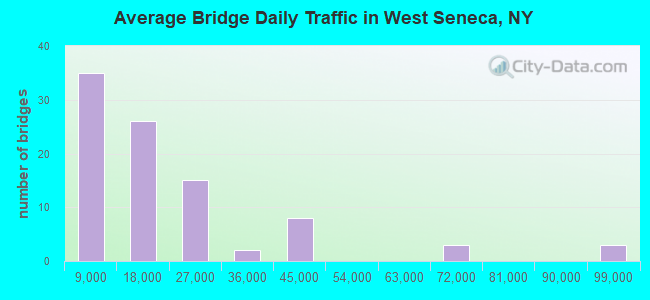
- 1,734,757Total average daily traffic
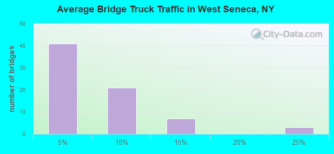
- 96,771Total average daily truck traffic
- National Bridge Inventory (NBI) Registered Bridges for West Seneca
- No street view available for this location
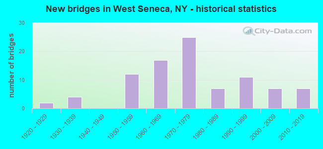
- New bridges - historical statistics
- 21920-1929
- 41930-1939
- 121950-1959
- 171960-1969
- 251970-1979
- 71980-1989
- 111990-1999
- 72000-2009
- 72010-2019
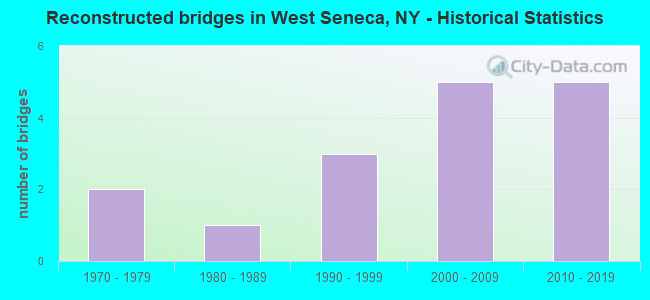
- Reconstructed bridges - Historical Statistics
- 21970-1979
- 11980-1989
- 31990-1999
- 52000-2009
- 52010-2019
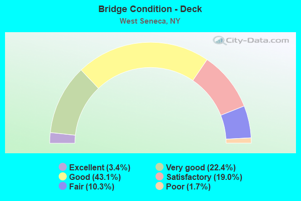
- Bridge Condition - Deck
- 3.4%Excellent
- 22.4%Very good
- 43.1%Good
- 19.0%Satisfactory
- 10.3%Fair
- 1.7%Poor
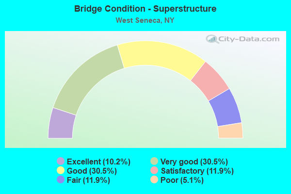
- Bridge Condition - Superstructure
- 10.2%Excellent
- 30.5%Very good
- 30.5%Good
- 11.9%Satisfactory
- 11.9%Fair
- 5.1%Poor
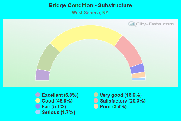
- Bridge Condition - Substructure
- 6.8%Excellent
- 16.9%Very good
- 45.8%Good
- 20.3%Satisfactory
- 5.1%Fair
- 3.4%Poor
- 1.7%Serious
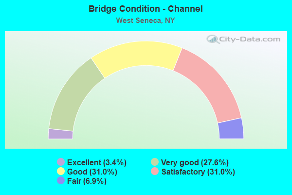
- Bridge Condition - Channel
- 3.4%Excellent
- 27.6%Very good
- 31.0%Good
- 31.0%Satisfactory
- 6.9%Fair
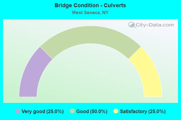
- Bridge Condition - Culverts
- 25.0%Very good
- 50.0%Good
- 25.0%Satisfactory
Find on map >> Show street view
Structure Number: 30119, Location: 1.2 MI W JCT SH16 & SH277 (Lat: 42.839769, Lng: -78.778072), Route carried "on" structure: State highway 16, Year Built: 1994, Status: Open, Structure Length: 2.23m (7.32ft), Average Daily Traffic: 6,996 (year 2019), Truck Traffic: 5%, Average Future Daily Traffic: 7,387 (year 2040), Design Load: HS 25 or greater, Features Intersected: NORFOLK SOUTHERN
Minimum Vertical Clearance: 30+ m (98+ ft), Kilometerpoint: 47.063, Lanes on structure: 4, Base Highway Network: Yes, Owner: County Highway Agency, Approaching Roadway Width: 13.4m (44.0ft), Skew: 2 degrees, Material/Design: Steel, Design/Construction: Stringer/Multi-beam, Number Of Spans In Main Unit: 1, Length of Maximum Span: 20.7m (67.9ft), Curb or Sidewalk Widths: Left: 1.5m (4.9ft), Right: 1.5m (4.9ft), Curb-To-Curb Width: 15.8m (51.8ft), Out-to-Out Width: 19.5m (64.0ft)
Condition: Deck: Very good, Superstructure: Excellent, Substructure: Good, Operating Rating: 81.3 metric tons, Method Used To Determine Operating Rating: Load and Resistance Factor Rating (LRFR) rating reported by rating factor(RF) method using HL-93 loadings, Inventory Rating: 62.9 metric tons, Method Used To Determine Inventory Rating: Load and Resistance Factor Rating (LRFR) rating reported by rating factor(RF) method using HL-93 loadings, Structural Evaluation: Better than present minimum criteria, Deck Geometry: Meets minimum limits, Underclear: Superior to present desirable criteria, Approach Roadway Alignment: Equal to present desirable criteria, Length Of Structure Improvement: 2.22m (7.28ft), Designated Inspection Frequency: Every 24 months, Inspection Date: August 2020, Bridge Improvement Cost: $4,244,000, Roadway Improvement Cost: $2,485,000, Total Project Cost: $6,729,000 ( Estimate for 2021), Deck Structure Type: Concrete Cast-file-Place, Wearing Surface/Protective System: Wearing Surface: Integral Concrete
Find on map >> Show street view
Structure Number: 332693, Location: JCT SH 240 & CO RD 101 (Lat: 42.829694, Lng: -78.775569), Route carried "on" structure: County highway , Year Built: 1955, Year Reconstructed: 1998, Status: Open, Structure Length: 5.15m (16.90ft), Average Daily Traffic: 16,726 (year 2020), Truck Traffic: 2%, Average Future Daily Traffic: 16,804 (year 2040), Design Load: HS 25 or greater, Features Intersected: CAZENOVIA CREEK, Facility Carried by Structure: RIDGE ROAD
Minimum Vertical Clearance: 30+ m (98+ ft), Kilometerpoint: 2.365, Lanes on structure: 4, Owner: County Highway Agency, Approaching Roadway Width: 15.8m (51.8ft), Skew: 2 degrees, Material/Design: Steel continuous, Design/Construction: Stringer/Multi-beam, Number Of Spans In Main Unit: 2, Length of Maximum Span: 25.2m (82.7ft), Curb or Sidewalk Widths: Left: 1.5m (4.9ft), Right: 1.5m (4.9ft), Curb-To-Curb Width: 15.8m (51.8ft), Out-to-Out Width: 19.4m (63.6ft)
Condition: Deck: Very good, Superstructure: Good, Substructure: Good, Channel: Satisfactory, Operating Rating: 27.5 metric tons, Method Used To Determine Operating Rating: Load and Resistance Factor Rating (LRFR) rating reported by rating factor(RF) method using HL-93 loadings, Inventory Rating: 21.4 metric tons, Method Used To Determine Inventory Rating: Load and Resistance Factor Rating (LRFR) rating reported by rating factor(RF) method using HL-93 loadings, Structural Evaluation: Somewhat better than minimum adequacy, Deck Geometry: Meets minimum limits, Waterway Adequacy: Equal to present desirable criteria, Approach Roadway Alignment: Equal to present desirable criteria, Length Of Structure Improvement: 5.15m (16.90ft), Designated Inspection Frequency: Every 24 months, Inspection Date: November 2021, Bridge Improvement Cost: $4,790,000, Roadway Improvement Cost: $2,805,000, Total Project Cost: $7,595,000 ( Estimate for 2021), Deck Structure Type: Concrete Cast-file-Place, Wearing Surface/Protective System: Wearing Surface: Integral Concrete, Deck Protection: Epoxy Coated Reinforcing
Find on map >> Show street view
Structure Number: 332702, Location: .9 MI SW JCT SH78 & SH354 (Lat: 42.858036, Lng: -78.708814), Route carried "on" structure: County highway , Year Built: 2002, Status: Open, Structure Length: 4.94m (16.21ft), Average Daily Traffic: 4,200 (year 2020), Truck Traffic: 3%, Average Future Daily Traffic: 5,196 (year 2040), Features Intersected: BUFFALO CREEK, Facility Carried by Structure: BORDEN ROAD
Minimum Vertical Clearance: 30+ m (98+ ft), Kilometerpoint: 0.692, Lanes on structure: 2, Owner: County Highway Agency, Approaching Roadway Width: 12.2m (40.0ft), Skew: 2 degrees, Material/Design: Steel, Design/Construction: Stringer/Multi-beam, Number Of Spans In Main Unit: 1, Length of Maximum Span: 47.8m (156.8ft), Curb-To-Curb Width: 12.3m (40.4ft), Out-to-Out Width: 13.3m (43.6ft)
Condition: Deck: Good, Superstructure: Very good, Substructure: Excellent, Channel: Very good, Operating Rating: 75.3 metric tons, Method Used To Determine Operating Rating: Load Factor (LF), Inventory Rating: 45.4 metric tons, Method Used To Determine Inventory Rating: Load Factor (LF), Structural Evaluation: Equal to present desirable criteria, Deck Geometry: Equal to present minimum criteria, Waterway Adequacy: Equal to present minimum criteria, Approach Roadway Alignment: Equal to present desirable criteria, Length Of Structure Improvement: 4.93m (16.17ft), Designated Inspection Frequency: Every 24 months, Inspection Date: November 2020, Bridge Improvement Cost: $3,184,000, Roadway Improvement Cost: $1,864,000, Total Project Cost: $5,048,000 ( Estimate for 2021), Deck Structure Type: Concrete Cast-file-Place, Wearing Surface/Protective System: Wearing Surface: Integral Concrete, Deck Protection: Epoxy Coated Reinforcing
Find on map >> Show street view
Structure Number: 332741, Location: 2.9 MI NW OF ORCHARD PARK (Lat: 42.791125, Lng: -78.792767), Route carried "on" structure: County highway , Year Built: 1988, Status: Open, Structure Length: 1.04m (3.41ft), Average Daily Traffic: 10,261 (year 2018), Truck Traffic: 3%, Average Future Daily Traffic: 10,835 (year 2040), Design Load: HS 20, Features Intersected: S BR SMOKES CREEK, Facility Carried by Structure: ABBOTT ROAD
Minimum Vertical Clearance: 30+ m (98+ ft), Kilometerpoint: 5.712, Lanes on structure: 4, Owner: County Highway Agency, Approaching Roadway Width: 17.7m (58.1ft), Skew: 2 degrees, Material/Design: Prestressed concrete, Design/Construction: Box Beam or Girders - Multiple, Number Of Spans In Main Unit: 1, Length of Maximum Span: 9.1m (29.9ft), Curb or Sidewalk Widths: Left: 0.0m, Right: 1.5m (4.9ft), Curb-To-Curb Width: 17.7m (58.1ft), Out-to-Out Width: 20.3m (66.6ft)
Condition: Deck: Good, Superstructure: Very good, Substructure: Satisfactory, Channel: Very good, Operating Rating: 76.2 metric tons, Method Used To Determine Operating Rating: Load Factor (LF), Inventory Rating: 40.8 metric tons, Method Used To Determine Inventory Rating: Load Factor (LF), Structural Evaluation: Equal to present minimum criteria, Deck Geometry: Somewhat better than minimum adequacy, Waterway Adequacy: Equal to present desirable criteria, Approach Roadway Alignment: Equal to present desirable criteria, Length Of Structure Improvement: 1.03m (3.38ft), Designated Inspection Frequency: Every 24 months, Inspection Date: April 2020, Bridge Improvement Cost: $1,217,000, Roadway Improvement Cost: $713,000, Total Project Cost: $1,930,000 ( Estimate for 2021), Wearing Surface/Protective System: Wearing Surface: Monolithic Concrete
Find on map >> Show street view
Structure Number: 332746, Location: 2.3 MI W OF ORCHARD PARK (Lat: 42.781908, Lng: -78.785961), Route carried "on" structure: County highway , Year Built: 1936, Status: Posted for load-capacity, Structure Length: 0.94m (3.08ft), Average Daily Traffic: 795 (year 2017), Truck Traffic: 3%, Average Future Daily Traffic: 1,113 (year 2037), Features Intersected: S BR SMOKES CREEK, Facility Carried by Structure: WEBSTERS CORS RD
Minimum Vertical Clearance: 30+ m (98+ ft), Kilometerpoint: 0.306, Lanes on structure: 2, Owner: County Highway Agency, Approaching Roadway Width: 5.2m (17.1ft), Skew: 4 degrees, Material/Design: Concrete, Design/Construction: Slab, Number Of Spans In Main Unit: 1, Length of Maximum Span: 8.2m (26.9ft), Curb-To-Curb Width: 7.3m (24.0ft), Out-to-Out Width: 15.8m (51.8ft)
Condition: Deck: Fair, Superstructure: Fair, Substructure: Satisfactory, Channel: Satisfactory, Operating Rating: 58.3 metric tons, Method Used To Determine Operating Rating: Load and Resistance Factor Rating (LRFR) rating reported by rating factor(RF) method using HL-93 loadings, Inventory Rating: 45.0 metric tons, Method Used To Determine Inventory Rating: Load and Resistance Factor Rating (LRFR) rating reported by rating factor(RF) method using HL-93 loadings, Structural Evaluation: Somewhat better than minimum adequacy, Deck Geometry: Meets minimum limits, Waterway Adequacy: Better than present minimum criteria, Approach Roadway Alignment: Equal to present desirable criteria, Length Of Structure Improvement: 0.94m (3.08ft), Designated Inspection Frequency: Every 24 months, Inspection Date: May 2020, Bridge Improvement Cost: $840,000, Roadway Improvement Cost: $492,000, Total Project Cost: $1,332,000 ( Estimate for 2021), Wearing Surface/Protective System: Wearing Surface: Bituminous
Find on map >> Show street view
Structure Number: 332752, Location: 2.8 MI NW OF ORCHARD PARK (Lat: 42.803811, Lng: -78.769353), Route carried "on" structure: County highway , Year Built: 1981, Status: Open, Structure Length: 4.05m (13.29ft), Average Daily Traffic: 2,631 (year 2020), Truck Traffic: 2%, Average Future Daily Traffic: 3,255 (year 2040), Design Load: HS 20, Features Intersected: N BR SMOKES CREEK, Facility Carried by Structure: BERG ROAD
Minimum Vertical Clearance: 30+ m (98+ ft), Kilometerpoint: 3.524, Lanes on structure: 2, Owner: County Highway Agency, Approaching Roadway Width: 12.2m (40.0ft), Skew: 6 degrees, Material/Design: Steel, Design/Construction: Stringer/Multi-beam, Number Of Spans In Main Unit: 2, Length of Maximum Span: 21.0m (68.9ft), Curb or Sidewalk Widths: Left: 1.4m (4.6ft), Right: 1.4m (4.6ft), Curb-To-Curb Width: 12.2m (40.0ft), Out-to-Out Width: 15.5m (50.9ft)
Condition: Deck: Satisfactory, Superstructure: Good, Substructure: Satisfactory, Channel: Fair, Operating Rating: 79.4 metric tons, Method Used To Determine Operating Rating: Load and Resistance Factor Rating (LRFR) rating reported by rating factor(RF) method using HL-93 loadings, Inventory Rating: 61.2 metric tons, Method Used To Determine Inventory Rating: Load and Resistance Factor Rating (LRFR) rating reported by rating factor(RF) method using HL-93 loadings, Structural Evaluation: Equal to present minimum criteria, Deck Geometry: Equal to present minimum criteria, Waterway Adequacy: Equal to present desirable criteria, Approach Roadway Alignment: Equal to present desirable criteria, Length Of Structure Improvement: 4.05m (13.29ft), Designated Inspection Frequency: Every 24 months, Inspection Date: October 2020, Bridge Improvement Cost: $4,581,000, Roadway Improvement Cost: $2,682,000, Total Project Cost: $7,263,000 ( Estimate for 2021), Deck Structure Type: Concrete Cast-file-Place, Wearing Surface/Protective System: Wearing Surface: Monolithic Concrete, Deck Protection: Epoxy Coated Reinforcing
Find on map >> Show street view
Structure Number: 332756, Location: 1 MILE NW OF ORCHARD PARK (Lat: 42.796361, Lng: -78.755442), Route carried "on" structure: County highway , Year Built: 2013, Status: Open, Structure Length: 1.16m (3.81ft), Average Daily Traffic: 6,549 (year 2017), Truck Traffic: 3%, Average Future Daily Traffic: 6,915 (year 2040), Design Load: HL 93, Features Intersected: SMOKES CREEK, Facility Carried by Structure: LAKE AVENUE
Minimum Vertical Clearance: 30+ m (98+ ft), Kilometerpoint: 7.482, Lanes on structure: 2, Owner: County Highway Agency, Approaching Roadway Width: 13.1m (43.0ft), Skew: 2 degrees, Material/Design: Concrete, Design/Construction: Culvert, Number Of Spans In Main Unit: 1, Length of Maximum Span: 10.9m (35.8ft), Curb-To-Curb Width: 13.5m (44.3ft), Out-to-Out Width: 15.6m (51.2ft)
Condition: Channel: Good, Culverts: Good, Operating Rating: 61.6 metric tons, Method Used To Determine Operating Rating: Load and Resistance Factor Rating (LRFR) rating reported by rating factor(RF) method using HL-93 loadings, Inventory Rating: 45.4 metric tons, Method Used To Determine Inventory Rating: Load and Resistance Factor Rating (LRFR) rating reported by rating factor(RF) method using HL-93 loadings, Structural Evaluation: Better than present minimum criteria, Deck Geometry: Superior to present desirable criteria, Waterway Adequacy: Equal to present minimum criteria, Approach Roadway Alignment: Equal to present desirable criteria, Length Of Structure Improvement: 1.15m (3.77ft), Designated Inspection Frequency: Every 24 months, Inspection Date: September 2021, Bridge Improvement Cost: $501,000, Roadway Improvement Cost: $293,000, Total Project Cost: $794,000 ( Estimate for 2021)
Find on map >> Show street view
Structure Number: 332767, Location: 2.7 MI N JCT I90 & US 20 (Lat: 42.818986, Lng: -78.784078), Route carried "on" structure: County highway , Year Built: 1989, Status: Open, Structure Length: 2.19m (7.19ft), Average Daily Traffic: 6,343 (year 2020), Truck Traffic: 3%, Average Future Daily Traffic: 7,848 (year 2040), Design Load: HS 20+Mod, Features Intersected: SMOKES CREEK, Facility Carried by Structure: LANGNER ROAD
Minimum Vertical Clearance: 30+ m (98+ ft), Kilometerpoint: 0.016, Lanes on structure: 2, Owner: County Highway Agency, Approaching Roadway Width: 9.8m (32.2ft), Skew: 3 degrees, Material/Design: Prestressed concrete, Design/Construction: Box Beam or Girders - Multiple, Number Of Spans In Main Unit: 1, Length of Maximum Span: 21.3m (69.9ft), Curb-To-Curb Width: 11.0m (36.1ft), Out-to-Out Width: 11.6m (38.1ft)
Condition: Deck: Satisfactory, Superstructure: Good, Substructure: Good, Channel: Satisfactory, Operating Rating: 89.8 metric tons, Method Used To Determine Operating Rating: Load Factor (LF), Inventory Rating: 39.0 metric tons, Method Used To Determine Inventory Rating: Load Factor (LF), Structural Evaluation: Better than present minimum criteria, Deck Geometry: Meets minimum limits, Waterway Adequacy: Equal to present desirable criteria, Approach Roadway Alignment: Equal to present desirable criteria, Length Of Structure Improvement: 2.19m (7.19ft), Designated Inspection Frequency: Every 24 months, Inspection Date: April 2020, Bridge Improvement Cost: $798,000, Roadway Improvement Cost: $467,000, Total Project Cost: $1,266,000 ( Estimate for 2021), Deck Structure Type: Concrete Cast-file-Place, Wearing Surface/Protective System: Wearing Surface: Integral Concrete, Deck Protection: Epoxy Coated Reinforcing
Find on map >> Show street view
Structure Number: 332768, Location: .8 MI SE JCT I90&RIDGE RD (Lat: 42.818694, Lng: -78.782911), Route carried "on" structure: County highway , Year Built: 1998, Status: Open, Structure Length: 1.95m (6.40ft), Average Daily Traffic: 3,447 (year 2017), Truck Traffic: 2%, Average Future Daily Traffic: 4,264 (year 2040), Design Load: HS 25 or greater, Features Intersected: SMOKES CREEK, Facility Carried by Structure: FISHER ROAD
Minimum Vertical Clearance: 30+ m (98+ ft), Kilometerpoint: 1.496, Lanes on structure: 2, Owner: County Highway Agency, Approaching Roadway Width: 9.1m (29.9ft), Skew: 2 degrees, Material/Design: Prestressed concrete, Design/Construction: Box Beam or Girders - Multiple, Number Of Spans In Main Unit: 1, Length of Maximum Span: 18.9m (62.0ft), Curb-To-Curb Width: 9.0m (29.5ft), Out-to-Out Width: 9.6m (31.5ft)
Condition: Deck: Good, Superstructure: Very good, Substructure: Excellent, Channel: Satisfactory, Operating Rating: 68.0 metric tons, Method Used To Determine Operating Rating: Load Factor (LF), Inventory Rating: 40.8 metric tons, Method Used To Determine Inventory Rating: Load Factor (LF), Structural Evaluation: Equal to present desirable criteria, Deck Geometry: Meets minimum limits, Waterway Adequacy: Somewhat better than minimum adequacy, Approach Roadway Alignment: Equal to present desirable criteria, Length Of Structure Improvement: 1.95m (6.40ft), Designated Inspection Frequency: Every 24 months, Inspection Date: December 2020, Bridge Improvement Cost: $651,000, Roadway Improvement Cost: $381,000, Total Project Cost: $1,032,000 ( Estimate for 2021), Deck Structure Type: Concrete Cast-file-Place, Wearing Surface/Protective System: Wearing Surface: Monolithic Concrete, Deck Protection: Epoxy Coated Reinforcing
Find on map >> Show street view
Structure Number: 332769, Location: .9 MI SE JCT I90&RIDGE RD (Lat: 42.818675, Lng: -78.780933), Route carried "on" structure: County highway , Year Built: 1999, Status: Open, Structure Length: 1.80m (5.91ft), Average Daily Traffic: 3,447 (year 2017), Truck Traffic: 2%, Average Future Daily Traffic: 4,264 (year 2040), Design Load: HS 25 or greater, Features Intersected: SMOKES CREEK, Facility Carried by Structure: FISHER ROAD
Minimum Vertical Clearance: 30+ m (98+ ft), Kilometerpoint: 1.722, Lanes on structure: 2, Owner: County Highway Agency, Approaching Roadway Width: 8.8m (28.9ft), Material/Design: Prestressed concrete, Design/Construction: Box Beam or Girders - Multiple, Number Of Spans In Main Unit: 1, Length of Maximum Span: 16.7m (54.8ft), Curb-To-Curb Width: 9.0m (29.5ft), Out-to-Out Width: 9.6m (31.5ft)
Condition: Deck: Good, Superstructure: Good, Substructure: Very good, Channel: Satisfactory, Operating Rating: 78.9 metric tons, Method Used To Determine Operating Rating: Load Factor (LF), Inventory Rating: 47.2 metric tons, Method Used To Determine Inventory Rating: Load Factor (LF), Structural Evaluation: Better than present minimum criteria, Deck Geometry: Meets minimum limits, Waterway Adequacy: Equal to present minimum criteria, Approach Roadway Alignment: Equal to present desirable criteria, Length Of Structure Improvement: 1.79m (5.87ft), Designated Inspection Frequency: Every 24 months, Inspection Date: April 2021, Bridge Improvement Cost: $612,000, Roadway Improvement Cost: $358,000, Total Project Cost: $970,000 ( Estimate for 2021), Deck Structure Type: Concrete Cast-file-Place, Wearing Surface/Protective System: Wearing Surface: Integral Concrete, Deck Protection: Epoxy Coated Reinforcing
Find on map >> Show street view
Structure Number: 33277, Location: 1 MI SE JCT I90&RIDGE RD (Lat: 42.818653, Lng: -78.777606), Route carried "on" structure: County highway , Year Built: 1999, Status: Open, Structure Length: 1.98m (6.50ft), Average Daily Traffic: 3,447 (year 2017), Truck Traffic: 2%, Average Future Daily Traffic: 4,264 (year 2040), Design Load: HS 25 or greater, Features Intersected: SMOKES CREEK, Facility Carried by Structure: FISHER ROAD
Minimum Vertical Clearance: 30+ m (98+ ft), Kilometerpoint: 1.963, Lanes on structure: 2, Owner: County Highway Agency, Approaching Roadway Width: 9.1m (29.9ft), Skew: 1 degrees, Material/Design: Prestressed concrete, Design/Construction: Box Beam or Girders - Multiple, Number Of Spans In Main Unit: 1, Length of Maximum Span: 19.5m (64.0ft), Curb-To-Curb Width: 9.0m (29.5ft), Out-to-Out Width: 9.6m (31.5ft)
Condition: Deck: Good, Superstructure: Very good, Substructure: Very good, Channel: Satisfactory, Operating Rating: 68.9 metric tons, Method Used To Determine Operating Rating: Load Factor (LF), Inventory Rating: 40.8 metric tons, Method Used To Determine Inventory Rating: Load Factor (LF), Structural Evaluation: Equal to present desirable criteria, Deck Geometry: Meets minimum limits, Waterway Adequacy: Equal to present minimum criteria, Approach Roadway Alignment: Equal to present desirable criteria, Length Of Structure Improvement: 1.98m (6.50ft), Designated Inspection Frequency: Every 24 months, Inspection Date: April 2021, Bridge Improvement Cost: $681,000, Roadway Improvement Cost: $399,000, Total Project Cost: $1,080,000 ( Estimate for 2021), Deck Structure Type: Concrete Cast-file-Place, Wearing Surface/Protective System: Wearing Surface: Integral Concrete, Deck Protection: Epoxy Coated Reinforcing
Find on map >> Show street view
Structure Number: 332806, Location: 1.5 MI N OF ORCHARD PARK (Lat: 42.789056, Lng: -78.740100), Route carried "on" structure: County highway , Year Built: 2004, Status: Open, Structure Length: 1.10m (3.61ft), Average Daily Traffic: 3,493 (year 2017), Truck Traffic: 2%, Average Future Daily Traffic: 4,321 (year 2040), Design Load: HS 25 or greater, Features Intersected: SMOKES CREEK, Facility Carried by Structure: MILE STRIP ROAD
Minimum Vertical Clearance: 30+ m (98+ ft), Kilometerpoint: 1.657, Lanes on structure: 2, Owner: County Highway Agency, Approaching Roadway Width: 10.1m (33.1ft), Skew: 4 degrees, Material/Design: Concrete, Design/Construction: Culvert, Number Of Spans In Main Unit: 1, Length of Maximum Span: 10.5m (34.4ft), Curb-To-Curb Width: 10.3m (33.8ft), Out-to-Out Width: 11.3m (37.1ft)
Condition: Channel: Good, Culverts: Very good, Operating Rating: 79.9 metric tons, Method Used To Determine Operating Rating: Field evaluation and documented engineering judgment, Inventory Rating: 40.8 metric tons, Method Used To Determine Inventory Rating: Field evaluation and documented engineering judgment, Structural Evaluation: Equal to present desirable criteria, Deck Geometry: Meets minimum limits, Waterway Adequacy: Equal to present minimum criteria, Approach Roadway Alignment: Equal to present desirable criteria, Length Of Structure Improvement: 1.09m (3.58ft), Designated Inspection Frequency: Every 24 months, Inspection Date: October 2020, Bridge Improvement Cost: $666,000, Roadway Improvement Cost: $390,000, Total Project Cost: $1,056,000 ( Estimate for 2021)
Find on map >> Show street view
Structure Number: 332884, Location: 1 MI W JCT SH400 & SH78 (Lat: 42.833094, Lng: -78.716572), Route carried "on" structure: Other road , Year Built: 1934, Year Reconstructed: 1985, Status: Open, Structure Length: 6.16m (20.21ft), Average Daily Traffic: 1,299 (year 2017), Truck Traffic: 4%, Average Future Daily Traffic: 1,819 (year 2037), Design Load: HS 20, Features Intersected: CAZENOVIA CREEK, Facility Carried by Structure: LEYDECKER ROAD
Minimum Vertical Clearance: 30+ m (98+ ft), Kilometerpoint: 1.883, Lanes on structure: 2, Owner: County Highway Agency, Approaching Roadway Width: 7.3m (24.0ft), Material/Design: Steel, Design/Construction: Girder and Floorbeam System, Number Of Spans In Main Unit: 4, Length of Maximum Span: 18.8m (61.7ft), Curb-To-Curb Width: 7.6m (24.9ft), Out-to-Out Width: 8.3m (27.2ft)
Condition: Deck: Fair, Superstructure: Fair, Substructure: Poor, Channel: Good, Operating Rating: 28.5 metric tons, Method Used To Determine Operating Rating: Load and Resistance Factor Rating (LRFR) rating reported by rating factor(RF) method using HL-93 loadings, Inventory Rating: 22.0 metric tons, Method Used To Determine Inventory Rating: Load and Resistance Factor Rating (LRFR) rating reported by rating factor(RF) method using HL-93 loadings, Structural Evaluation: Meets minimum limits, Deck Geometry: Meets minimum limits, Waterway Adequacy: Superior to present desirable criteria, Approach Roadway Alignment: Equal to present minimum criteria, Length Of Structure Improvement: 6.15m (20.18ft), Designated Inspection Frequency: Every 24 months, Critical Feature Inspection Frequency: Every 24 months, Inspection Date: September 2021, Critical Feature Inspection Date: September 2021, Bridge Improvement Cost: $2,618,000, Roadway Improvement Cost: $1,533,000, Total Project Cost: $4,151,000 ( Estimate for 2021), Deck Structure Type: Concrete Cast-file-Place, Wearing Surface/Protective System: Wearing Surface: Integral Concrete, Deck Protection: Epoxy Coated Reinforcing
Find on map >> Show street view
Structure Number: 336208, Location: .9 MI NE JCT US219 & I90 (Lat: 42.838239, Lng: -78.778994), Route carried "on" structure: County highway , Year Built: 2012, Status: Open, Structure Length: 1.62m (5.31ft), Average Daily Traffic: 6,798 (year 2020), Truck Traffic: 3%, Average Future Daily Traffic: 8,411 (year 2040), Design Load: HS 25 or greater, Features Intersected: NORFOLK SOUTHERN, Facility Carried by Structure: SENECA STREET
Minimum Vertical Clearance: 30+ m (98+ ft), Kilometerpoint: 1.046, Lanes on structure: 2, Owner: County Highway Agency, Approaching Roadway Width: 10.7m (35.1ft), Material/Design: Concrete, Design/Construction: Frame, Number Of Spans In Main Unit: 1, Length of Maximum Span: 15.2m (49.9ft), Curb-To-Curb Width: 12.0m (39.4ft), Out-to-Out Width: 13.0m (42.7ft)
Condition: Superstructure: Very good, Substructure: Good, Operating Rating: 83.5 metric tons, Method Used To Determine Operating Rating: Field evaluation and documented engineering judgment, Inventory Rating: 40.8 metric tons, Method Used To Determine Inventory Rating: Field evaluation and documented engineering judgment, Structural Evaluation: Better than present minimum criteria, Deck Geometry: Somewhat better than minimum adequacy, Underclear: Superior to present desirable criteria, Approach Roadway Alignment: Equal to present desirable criteria, Length Of Structure Improvement: 1.61m (5.28ft), Designated Inspection Frequency: Every 24 months, Inspection Date: August 2020, Bridge Improvement Cost: $673,000, Roadway Improvement Cost: $394,000, Total Project Cost: $1,067,000 ( Estimate for 2021), Wearing Surface/Protective System: Wearing Surface: Bituminous
Find on map >> Show street view
Structure Number: 33623, Location: 1.6 MI E OF RT 90I ENTRNC (Lat: 42.789417, Lng: -78.790047), Route carried "on" structure: Spur State highway 179, Year Built: 1965, Status: Open, Structure Length: 0.85m (2.79ft), Average Daily Traffic: 19,198 (year 2019), Truck Traffic: 3%, Average Future Daily Traffic: 19,288 (year 2040), Features Intersected: S BR SMOKES CRK
Minimum Vertical Clearance: 30+ m (98+ ft), Kilometerpoint: 4.537, Lanes on structure: 4, Base Highway Network: Yes, Owner: State Highway Agency, Approaching Roadway Width: 16.2m (53.1ft), Material/Design: Concrete, Design/Construction: Culvert, Number Of Spans In Main Unit: 2, Length of Maximum Span: 3.9m (12.8ft)
Condition: Channel: Satisfactory, Culverts: Satisfactory, Operating Rating: 75.4 metric tons, Method Used To Determine Operating Rating: Field evaluation and documented engineering judgment, Inventory Rating: 32.7 metric tons, Method Used To Determine Inventory Rating: Field evaluation and documented engineering judgment, Structural Evaluation: Equal to present minimum criteria, Waterway Adequacy: Somewhat better than minimum adequacy, Approach Roadway Alignment: Equal to present desirable criteria, Length Of Structure Improvement: 0.85m (2.79ft), Designated Inspection Frequency: Every 24 months, Inspection Date: July 2020, Bridge Improvement Cost: $381,000, Roadway Improvement Cost: $223,000, Total Project Cost: $604,000 ( Estimate for 2021)
Find on map >> Show street view
Structure Number: 336246, Location: .2 MI E JCT I90 & CR 137 (Lat: 42.828711, Lng: -78.785161), Route carried "on" structure: County highway , Year Built: 1997, Status: Open, Structure Length: 2.01m (6.59ft), Average Daily Traffic: 19,169 (year 2018), Truck Traffic: 4%, Average Future Daily Traffic: 19,259 (year 2040), Design Load: HS 25 or greater, Features Intersected: NORFOLK SOUTHERN, Facility Carried by Structure: RIDGE ROAD
Minimum Vertical Clearance: 30+ m (98+ ft), Kilometerpoint: 1.529, Lanes on structure: 4, Owner: County Highway Agency, Approaching Roadway Width: 15.8m (51.8ft), Skew: 3 degrees, Material/Design: Prestressed concrete, Design/Construction: Box Beam or Girders - Multiple, Number Of Spans In Main Unit: 1, Length of Maximum Span: 18.8m (61.7ft), Curb or Sidewalk Widths: Left: 3.7m (12.1ft), Right: 0.0m, Curb-To-Curb Width: 15.8m (51.8ft), Out-to-Out Width: 20.2m (66.3ft)
Condition: Deck: Good, Superstructure: Very good, Substructure: Good, Operating Rating: 75.3 metric tons, Method Used To Determine Operating Rating: Load Factor (LF), Inventory Rating: 40.8 metric tons, Method Used To Determine Inventory Rating: Load Factor (LF), Structural Evaluation: Better than present minimum criteria, Deck Geometry: Meets minimum limits, Underclear: Better than present minimum criteria, Approach Roadway Alignment: Equal to present desirable criteria, Length Of Structure Improvement: 2.01m (6.59ft), Designated Inspection Frequency: Every 24 months, Inspection Date: November 2021, Bridge Improvement Cost: $2,406,000, Roadway Improvement Cost: $1,409,000, Total Project Cost: $3,815,000 ( Estimate for 2021), Deck Structure Type: Concrete Cast-file-Place, Wearing Surface/Protective System: Wearing Surface: Integral Concrete, Deck Protection: Epoxy Coated Reinforcing
Find on map >> Show street view
Structure Number: 5011919, Location: JCT RTS 16 + I-90 (Lat: 42.843967, Lng: -78.792683), Route carried "on" structure: Interstate 90, Year Built: 1957, Year Reconstructed: 2019, Status: Open, Structure Length: 4.91m (16.11ft), Average Daily Traffic: 69,290 (year 2017), Truck Traffic: 12%, Average Future Daily Traffic: 77,653 (year 2040), Design Load: HL 93, Features Intersected: RTE 16
Minimum Vertical Clearance: 30+ m (98+ ft), Kilometerpoint: 42.011, Lanes on structure: 6, Lanes under structure: 4, Base Highway Network: Yes, Toll: On Interstate toll segment, Owner: State Toll Authority, Approaching Roadway Width: 32.6m (107.0ft), Skew: 22 degrees, Material/Design: Steel continuous, Design/Construction: Stringer/Multi-beam, Number Of Spans In Main Unit: 3, Length of Maximum Span: 23.2m (76.1ft), Curb-To-Curb Width: 32.7m (107.3ft), Out-to-Out Width: 34.5m (113.2ft)
Condition: Deck: Very good, Superstructure: Excellent, Substructure: Good, Operating Rating: 96.2 metric tons, Method Used To Determine Operating Rating: Load Factor (LF), Inventory Rating: 57.2 metric tons, Method Used To Determine Inventory Rating: Load Factor (LF), Structural Evaluation: Better than present minimum criteria, Deck Geometry: Superior to present desirable criteria, Underclear: Somewhat better than minimum adequacy, Approach Roadway Alignment: Equal to present desirable criteria, Length Of Structure Improvement: 4.90m (16.08ft), Designated Inspection Frequency: Every 24 months, Inspection Date: November 2021, Bridge Improvement Cost: $6,855,000, Roadway Improvement Cost: $4,014,000, Total Project Cost: $10,869,000 ( Estimate for 2021), Deck Structure Type: Concrete Cast-file-Place, Wearing Surface/Protective System: Wearing Surface: Integral Concrete, Deck Protection: Galvanized Reinforcing
Find on map >> Show street view
Structure Number: 5042589, Location: TOWN OF WEST SENECA (Lat: 42.837186, Lng: -78.793100), Route carried "on" structure: Interstate 90, Year Built: 1958, Year Reconstructed: 2019, Status: Open, Structure Length: 5.33m (17.49ft), Average Daily Traffic: 69,290 (year 2017), Truck Traffic: 12%, Average Future Daily Traffic: 77,653 (year 2040), Design Load: HL 93, Features Intersected: RTE 950M
Minimum Vertical Clearance: 30+ m (98+ ft), Kilometerpoint: 41.239, Lanes on structure: 8, Lanes under structure: 4, Base Highway Network: Yes, Toll: On Interstate toll segment, Owner: State Toll Authority, Approaching Roadway Width: 44.5m (146.0ft), Skew: 22 degrees, Material/Design: Steel continuous, Design/Construction: Stringer/Multi-beam, Number Of Spans In Main Unit: 3, Length of Maximum Span: 24.1m (79.1ft), Curb-To-Curb Width: 44.5m (146.0ft), Out-to-Out Width: 46.3m (151.9ft)
Condition: Deck: Very good, Superstructure: Excellent, Substructure: Good, Operating Rating: 77.1 metric tons, Method Used To Determine Operating Rating: Load Factor (LF), Inventory Rating: 46.3 metric tons, Method Used To Determine Inventory Rating: Load Factor (LF), Structural Evaluation: Better than present minimum criteria, Deck Geometry: Superior to present desirable criteria, Underclear: High priority of corrective action, Approach Roadway Alignment: Equal to present desirable criteria, Length Of Structure Improvement: 5.33m (17.49ft), Designated Inspection Frequency: Every 24 months, Inspection Date: November 2021, Bridge Improvement Cost: $8,937,000, Roadway Improvement Cost: $5,233,000, Total Project Cost: $14,170,000 ( Estimate for 2021), Deck Structure Type: Concrete Cast-file-Place, Wearing Surface/Protective System: Wearing Surface: Integral Concrete, Deck Protection: Galvanized Reinforcing
Find on map >> Show street view
Structure Number: 5060589, Location: JCT RTS 400 + 240 (Lat: 42.849661, Lng: -78.787928), Route carried "on" structure: State highway 400, Year Built: 2016, Status: Open, Structure Length: 2.62m (8.60ft), Average Daily Traffic: 34,001 (year 2019), Truck Traffic: 6%, Average Future Daily Traffic: 39,400 (year 2040), Design Load: HL 93, Features Intersected: RTE 240
Minimum Vertical Clearance: 4.26m (13.98ft), Kilometerpoint: 27.047, Lanes on structure: 6, Lanes under structure: 2, Base Highway Network: Yes, Owner: State Toll Authority, Maintenance Responsibility: State Highway Agency, Approaching Roadway Width: 31.4m (103.0ft), Skew: 20 degrees, Material/Design: Prestressed concrete, Design/Construction: Stringer/Multi-beam, Number Of Spans In Main Unit: 1, Length of Maximum Span: 24.7m (81.0ft), Curb-To-Curb Width: 31.4m (103.0ft), Out-to-Out Width: 33.3m (109.3ft)
Condition: Deck: Excellent, Superstructure: Excellent, Substructure: Excellent, Operating Rating: 61.9 metric tons, Method Used To Determine Operating Rating: Load and Resistance Factor Rating (LRFR) rating reported by rating factor(RF) method using HL-93 loadings, Inventory Rating: 47.0 metric tons, Method Used To Determine Inventory Rating: Load and Resistance Factor Rating (LRFR) rating reported by rating factor(RF) method using HL-93 loadings, Structural Evaluation: Superior to present desirable criteria, Deck Geometry: Superior to present desirable criteria, Underclear: Equal to present minimum criteria, Approach Roadway Alignment: Equal to present desirable criteria, Length Of Structure Improvement: 2.62m (8.60ft), Designated Inspection Frequency: Every 24 months, Inspection Date: December 2020, Bridge Improvement Cost: $5,031,000, Roadway Improvement Cost: $2,946,000, Total Project Cost: $7,977,000 ( Estimate for 2021), Deck Structure Type: Concrete Cast-file-Place, Wearing Surface/Protective System: Wearing Surface: Bituminous
Find on map >> Show street view
Structure Number: 5512079, Location: .7 MI S JCT I90 & SH 354 (Lat: 42.867786, Lng: -78.791297), Route carried "on" structure: Interstate 90, Year Built: 2002, Status: Open, Structure Length: 11.22m (36.81ft), Average Daily Traffic: 97,359 (year 2018), Truck Traffic: 10%, Average Future Daily Traffic: 109,110 (year 2040), Design Load: HS 25 or greater, Features Intersected: BUFFALO RIVER
Minimum Vertical Clearance: 30+ m (98+ ft), Kilometerpoint: 44.666, Lanes on structure: 8, Base Highway Network: Yes, Owner: State Toll Authority, Approaching Roadway Width: 41.5m (136.2ft), Skew: 23 degrees, Material/Design: Steel continuous, Design/Construction: Stringer/Multi-beam, Number Of Spans In Main Unit: 4, Length of Maximum Span: 27.7m (90.9ft), Curb-To-Curb Width: 41.2m (135.2ft), Out-to-Out Width: 43.1m (141.4ft)
Condition: Deck: Good, Superstructure: Very good, Substructure: Satisfactory, Channel: Satisfactory, Operating Rating: 92.2 metric tons, Method Used To Determine Operating Rating: Field evaluation and documented engineering judgment, Inventory Rating: 40.8 metric tons, Method Used To Determine Inventory Rating: Field evaluation and documented engineering judgment, Structural Evaluation: Equal to present minimum criteria, Deck Geometry: Superior to present desirable criteria, Waterway Adequacy: Meets minimum limits, Approach Roadway Alignment: Equal to present desirable criteria, Length Of Structure Improvement: 11.21m (36.78ft), Designated Inspection Frequency: Every 24 months, Inspection Date: May 2020, Bridge Improvement Cost: $17,784,000, Roadway Improvement Cost: $10,414,000, Total Project Cost: $28,198,000 ( Estimate for 2021), Deck Structure Type: Concrete Cast-file-Place, Wearing Surface/Protective System: Wearing Surface: Integral Concrete, Deck Protection: Galvanized Reinforcing
Find on map >> Show street view
Structure Number: 5512089, Location: 1.3 MI S JCT I90 & SH 354 (Lat: 42.864619, Lng: -78.791628), Route carried "on" structure: Interstate 90, Year Built: 2002, Status: Open, Structure Length: 3.72m (12.20ft), Average Daily Traffic: 97,359 (year 2018), Truck Traffic: 10%, Average Future Daily Traffic: 109,110 (year 2040), Design Load: HS 25 or greater, Features Intersected: MINERAL SPRINGS RD
Minimum Vertical Clearance: 30+ m (98+ ft), Kilometerpoint: 44.360, Lanes on structure: 8, Lanes under structure: 2, Base Highway Network: Yes, Toll: On Interstate toll segment, Owner: State Toll Authority, Approaching Roadway Width: 41.5m (136.2ft), Skew: 23 degrees, Material/Design: Steel, Design/Construction: Stringer/Multi-beam, Number Of Spans In Main Unit: 1, Length of Maximum Span: 36.6m (120.1ft), Curb-To-Curb Width: 41.2m (135.2ft), Out-to-Out Width: 43.1m (141.4ft)
Condition: Deck: Good, Superstructure: Very good, Substructure: Very good, Operating Rating: 58.0 metric tons, Method Used To Determine Operating Rating: Load and Resistance Factor Rating (LRFR) rating reported by rating factor(RF) method using HL-93 loadings, Inventory Rating: 44.7 metric tons, Method Used To Determine Inventory Rating: Load and Resistance Factor Rating (LRFR) rating reported by rating factor(RF) method using HL-93 loadings, Structural Evaluation: Equal to present desirable criteria, Deck Geometry: Superior to present desirable criteria, Underclear: Equal to present minimum criteria, Approach Roadway Alignment: Equal to present desirable criteria, Length Of Structure Improvement: 3.71m (12.17ft), Designated Inspection Frequency: Every 24 months, Inspection Date: November 2020, Bridge Improvement Cost: $8,140,000, Roadway Improvement Cost: $4,767,000, Total Project Cost: $12,907,000 ( Estimate for 2021), Deck Structure Type: Concrete Cast-file-Place, Wearing Surface/Protective System: Wearing Surface: Integral Concrete, Deck Protection: Galvanized Reinforcing
Find on map >> Show street view
Structure Number: 5512099, Location: 1.0 MI N JCT I90(Lat: 42.854619, Lng: -78.790836), Route carried "on" structure: Interstate 90, Year Built: 1956, Year Reconstructed: 2002, Status: Open, Structure Length: 16.00m (52.49ft), Average Daily Traffic: 97,359 (year 2018), Truck Traffic: 10%, Average Future Daily Traffic: 109,110 (year 2040), Design Load: HS 25 or greater, Features Intersected: INDIAN CHURCH RD, NORFOL
Minimum Vertical Clearance: 30+ m (98+ ft), Kilometerpoint: 43.234, Lanes on structure: 9, Lanes under structure: 2, Base Highway Network: Yes, Toll: On Interstate toll segment, Owner: State Toll Authority, Approaching Roadway Width: 45.1m (148.0ft), Skew: 22 degrees, Material/Design: Steel continuous, Design/Construction: Stringer/Multi-beam, Number Of Spans In Main Unit: 8, Length of Maximum Span: 27.4m (89.9ft), Curb-To-Curb Width: 44.9m (147.3ft), Out-to-Out Width: 46.7m (153.2ft)
Condition: Deck: Good, Superstructure: Very good, Substructure: Satisfactory, Operating Rating: 53.5 metric tons, Method Used To Determine Operating Rating: Load and Resistance Factor Rating (LRFR) rating reported by rating factor(RF) method using HL-93 loadings, Inventory Rating: 41.1 metric tons, Method Used To Determine Inventory Rating: Load and Resistance Factor Rating (LRFR) rating reported by rating factor(RF) method using HL-93 loadings, Structural Evaluation: Equal to present minimum criteria, Deck Geometry: Superior to present desirable criteria, Underclear: Superior to present desirable criteria, Approach Roadway Alignment: Equal to present desirable criteria, Length Of Structure Improvement: 16.00m (52.49ft), Designated Inspection Frequency: Every 24 months, Inspection Date: April 2021, Bridge Improvement Cost: $25,751,000, Roadway Improvement Cost: $15,080,000, Total Project Cost: $40,830,000 ( Estimate for 2021), Deck Structure Type: Concrete Cast-file-Place, Wearing Surface/Protective System: Wearing Surface: Integral Concrete, Deck Protection: Galvanized Reinforcing
Structure Number: 5512099, Location: 1.0 MI N JCT I90
Minimum Vertical Clearance: 30+ m (98+ ft), Kilometerpoint: 43.234, Lanes on structure: 9, Lanes under structure: 2, Base Highway Network: Yes, Toll: On Interstate toll segment, Owner: State Toll Authority, Approaching Roadway Width: 45.1m (148.0ft), Skew: 22 degrees, Material/Design: Steel continuous, Design/Construction: Stringer/Multi-beam, Number Of Spans In Main Unit: 8, Length of Maximum Span: 27.4m (89.9ft), Curb-To-Curb Width: 44.9m (147.3ft), Out-to-Out Width: 46.7m (153.2ft)
Condition: Deck: Good, Superstructure: Very good, Substructure: Satisfactory, Operating Rating: 53.5 metric tons, Method Used To Determine Operating Rating: Load and Resistance Factor Rating (LRFR) rating reported by rating factor(RF) method using HL-93 loadings, Inventory Rating: 41.1 metric tons, Method Used To Determine Inventory Rating: Load and Resistance Factor Rating (LRFR) rating reported by rating factor(RF) method using HL-93 loadings, Structural Evaluation: Equal to present minimum criteria, Deck Geometry: Superior to present desirable criteria, Underclear: Superior to present desirable criteria, Approach Roadway Alignment: Equal to present desirable criteria, Length Of Structure Improvement: 16.00m (52.49ft), Designated Inspection Frequency: Every 24 months, Inspection Date: April 2021, Bridge Improvement Cost: $25,751,000, Roadway Improvement Cost: $15,080,000, Total Project Cost: $40,830,000 ( Estimate for 2021), Deck Structure Type: Concrete Cast-file-Place, Wearing Surface/Protective System: Wearing Surface: Integral Concrete, Deck Protection: Galvanized Reinforcing
Find on map >> Show street view
Structure Number: 5512109, Location: JCT OF RTS I90 AND 400 (Lat: 42.849822, Lng: -78.790281), Route carried "on" structure: Ramp State highway , Year Built: 1998, Status: Open, Structure Length: 6.34m (20.80ft), Average Daily Traffic: 3,347 (year 2017), Truck Traffic: 9%, Average Future Daily Traffic: 3,750 (year 2040), Design Load: HS 25 or greater, Features Intersected: 90IX, RTE I90, Facility Carried by Structure: NY Route 400 Ramp
Minimum Vertical Clearance: 30+ m (98+ ft), Kilometerpoint: 0.145, Lanes on structure: 3, Lanes under structure: 7, Owner: State Toll Authority, Approaching Roadway Width: 11.6m (38.1ft), Skew: 20 degrees, Material/Design: Steel continuous, Design/Construction: Stringer/Multi-beam, Number Of Spans In Main Unit: 2, Length of Maximum Span: 32.3m (106.0ft), Curb-To-Curb Width: 18.6m (61.0ft), Out-to-Out Width: 20.0m (65.6ft)
Condition: Deck: Good, Superstructure: Good, Substructure: Good, Operating Rating: 94.1 metric tons, Method Used To Determine Operating Rating: Field evaluation and documented engineering judgment, Inventory Rating: 40.8 metric tons, Method Used To Determine Inventory Rating: Field evaluation and documented engineering judgment, Structural Evaluation: Better than present minimum criteria, Deck Geometry: Superior to present desirable criteria, Underclear: High priority of corrective action, Approach Roadway Alignment: Equal to present minimum criteria, Length Of Structure Improvement: 6.33m (20.77ft), Designated Inspection Frequency: Every 24 months, Inspection Date: May 2020, Bridge Improvement Cost: $4,715,000, Roadway Improvement Cost: $2,761,000, Total Project Cost: $7,476,000 ( Estimate for 2021), Deck Structure Type: Concrete Cast-file-Place, Wearing Surface/Protective System: Wearing Surface: Integral Concrete, Deck Protection: Galvanized Reinforcing
Find on map >> Show street view
Structure Number: 5512119, Location: 0.5 MI S JCT I90 < RTE 16 (Lat: 42.841281, Lng: -78.792992), Route carried "on" structure: Interstate 90, Year Built: 1957, Year Reconstructed: 2019, Status: Open, Structure Length: 11.00m (36.09ft), Average Daily Traffic: 69,290 (year 2017), Truck Traffic: 12%, Average Future Daily Traffic: 77,653 (year 2040), Design Load: HS 20+Mod, Features Intersected: CAZENOVIA CREEK
Minimum Vertical Clearance: 30+ m (98+ ft), Kilometerpoint: 41.673, Lanes on structure: 6, Base Highway Network: Yes, Owner: State Toll Authority, Approaching Roadway Width: 34.1m (111.9ft), Skew: 32 degrees, Material/Design: Steel, Design/Construction: Stringer/Multi-beam, Number Of Spans In Main Unit: 4, Length of Maximum Span: 33.2m (108.9ft), Curb-To-Curb Width: 33.9m (111.2ft), Out-to-Out Width: 34.5m (113.2ft)
Condition: Deck: Fair, Superstructure: Satisfactory, Substructure: Fair, Channel: Good, Operating Rating: 75.3 metric tons, Method Used To Determine Operating Rating: Load Factor (LF), Inventory Rating: 32.7 metric tons, Method Used To Determine Inventory Rating: Load Factor (LF), Structural Evaluation: Somewhat better than minimum adequacy, Deck Geometry: Superior to present desirable criteria, Waterway Adequacy: Superior to present desirable criteria, Approach Roadway Alignment: Equal to present desirable criteria, Length Of Structure Improvement: 11.00m (36.09ft), Designated Inspection Frequency: Every 24 months, Inspection Date: November 2021, Bridge Improvement Cost: $14,386,000, Roadway Improvement Cost: $8,425,000, Total Project Cost: $22,811,000 ( Estimate for 2021), Deck Structure Type: Concrete Cast-file-Place, Wearing Surface/Protective System: Wearing Surface: Bituminous, Membrane: Other
Find on map >> Show street view
Structure Number: 5512129, Location: 1.7 MI N JCT I90(Lat: 42.823697, Lng: -78.791181), Route carried "on" structure: Interstate 90, Year Built: 1958, Year Reconstructed: 2019, Status: Open, Structure Length: 3.02m (9.91ft), Average Daily Traffic: 30,919 (year 2017), Truck Traffic: 21%, Average Future Daily Traffic: 34,650 (year 2040), Design Load: HS 20+Mod, Features Intersected: SMOKE CREEK
Minimum Vertical Clearance: 30+ m (98+ ft), Kilometerpoint: 39.742, Lanes on structure: 4, Base Highway Network: Yes, Owner: State Toll Authority, Approaching Roadway Width: 39.6m (129.9ft), Skew: 11 degrees, Material/Design: Steel, Design/Construction: Stringer/Multi-beam, Number Of Spans In Main Unit: 1, Length of Maximum Span: 29.3m (96.1ft), Curb-To-Curb Width: 39.6m (129.9ft), Out-to-Out Width: 41.5m (136.2ft)
Condition: Deck: Very good, Superstructure: Satisfactory, Substructure: Good, Channel: Good, Operating Rating: 83.5 metric tons, Method Used To Determine Operating Rating: Load Factor (LF), Inventory Rating: 49.9 metric tons, Method Used To Determine Inventory Rating: Load Factor (LF), Structural Evaluation: Equal to present minimum criteria, Deck Geometry: Superior to present desirable criteria, Waterway Adequacy: Superior to present desirable criteria, Approach Roadway Alignment: Equal to present desirable criteria, Length Of Structure Improvement: 3.01m (9.88ft), Designated Inspection Frequency: Every 24 months, Inspection Date: November 2021, Bridge Improvement Cost: $5,573,000, Roadway Improvement Cost: $3,263,000, Total Project Cost: $8,836,000 ( Estimate for 2021), Deck Structure Type: Concrete Cast-file-Place, Wearing Surface/Protective System: Wearing Surface: Integral Concrete, Deck Protection: Galvanized Reinforcing
Structure Number: 5512129, Location: 1.7 MI N JCT I90
Minimum Vertical Clearance: 30+ m (98+ ft), Kilometerpoint: 39.742, Lanes on structure: 4, Base Highway Network: Yes, Owner: State Toll Authority, Approaching Roadway Width: 39.6m (129.9ft), Skew: 11 degrees, Material/Design: Steel, Design/Construction: Stringer/Multi-beam, Number Of Spans In Main Unit: 1, Length of Maximum Span: 29.3m (96.1ft), Curb-To-Curb Width: 39.6m (129.9ft), Out-to-Out Width: 41.5m (136.2ft)
Condition: Deck: Very good, Superstructure: Satisfactory, Substructure: Good, Channel: Good, Operating Rating: 83.5 metric tons, Method Used To Determine Operating Rating: Load Factor (LF), Inventory Rating: 49.9 metric tons, Method Used To Determine Inventory Rating: Load Factor (LF), Structural Evaluation: Equal to present minimum criteria, Deck Geometry: Superior to present desirable criteria, Waterway Adequacy: Superior to present desirable criteria, Approach Roadway Alignment: Equal to present desirable criteria, Length Of Structure Improvement: 3.01m (9.88ft), Designated Inspection Frequency: Every 24 months, Inspection Date: November 2021, Bridge Improvement Cost: $5,573,000, Roadway Improvement Cost: $3,263,000, Total Project Cost: $8,836,000 ( Estimate for 2021), Deck Structure Type: Concrete Cast-file-Place, Wearing Surface/Protective System: Wearing Surface: Integral Concrete, Deck Protection: Galvanized Reinforcing
Find on map >> Show street view
Structure Number: 5512131, Location: 0.5 MI S JCT I90/RIDGE RD (Lat: 42.819347, Lng: -78.791328), Route carried "on" structure: Interstate 90, Year Built: 2018, Status: Open, Structure Length: 9.42m (30.91ft), Average Daily Traffic: 15,460 (year 2017), Truck Traffic: 21%, Average Future Daily Traffic: 17,325 (year 2040), Design Load: HL 93, Features Intersected: NORFOLK SOUTHERN RR
Minimum Vertical Clearance: 32.69m (107.25ft), Kilometerpoint: 39.227, Lanes on structure: 2, Owner: State Toll Authority, Approaching Roadway Width: 18.0m (59.1ft), Skew: 5 degrees, Material/Design: Steel continuous, Design/Construction: Stringer/Multi-beam, Number Of Spans In Main Unit: 2, Length of Maximum Span: 51.8m (169.9ft), Curb-To-Curb Width: 18.0m (59.1ft), Out-to-Out Width: 18.9m (62.0ft)
Condition: Deck: Very good, Superstructure: Very good, Substructure: Very good, Inventory Rating: 40.8 metric tons, Method Used To Determine Inventory Rating: Field evaluation and documented engineering judgment, Structural Evaluation: Equal to present desirable criteria, Deck Geometry: Superior to present desirable criteria, Underclear: Better than present minimum criteria, Approach Roadway Alignment: Equal to present desirable criteria, Designated Inspection Frequency: Every 24 months, Inspection Date: November 2021, Deck Structure Type: Concrete Cast-file-Place, Wearing Surface/Protective System: Wearing Surface: Integral Concrete, Deck Protection: Galvanized Reinforcing
Find on map >> Show street view
Structure Number: 5512132, Location: 0.5 MI S JCT I90/RIDGE RD (Lat: 42.819628, Lng: -78.791108), Route carried "on" structure: Interstate 90, Year Built: 2019, Status: Open, Structure Length: 9.42m (30.91ft), Average Daily Traffic: 15,460 (year 2017), Truck Traffic: 21%, Average Future Daily Traffic: 17,325 (year 2040), Design Load: HL 93, Features Intersected: NORFOLK SOUTHERN RR
Minimum Vertical Clearance: 32.69m (107.25ft), Kilometerpoint: 39.260, Lanes on structure: 2, Owner: State Toll Authority, Approaching Roadway Width: 18.0m (59.1ft), Skew: 5 degrees, Material/Design: Steel continuous, Design/Construction: Stringer/Multi-beam, Number Of Spans In Main Unit: 2, Length of Maximum Span: 51.8m (169.9ft), Curb-To-Curb Width: 18.0m (59.1ft), Out-to-Out Width: 18.9m (62.0ft)
Condition: Deck: Very good, Superstructure: Very good, Substructure: Very good, Inventory Rating: 40.8 metric tons, Method Used To Determine Inventory Rating: Field evaluation and documented engineering judgment, Structural Evaluation: Equal to present desirable criteria, Deck Geometry: Superior to present desirable criteria, Underclear: Better than present minimum criteria, Approach Roadway Alignment: Equal to present desirable criteria, Designated Inspection Frequency: Every 24 months, Inspection Date: November 2021, Deck Structure Type: Concrete Cast-file-Place, Wearing Surface/Protective System: Wearing Surface: Integral Concrete, Deck Protection: Galvanized Reinforcing
Find on map >> Show street view
Structure Number: 104261, Location: 1.2 MI S JCT SH240 &SH354 (Lat: 42.854547, Lng: -78.787719), Route carried "under" structure: County highway , Year Built: 1987, Structure Length: 0. m, Average Daily Traffic: 4,144 (year 2020), Truck Traffic: 2%, Features Intersected: INDIN CH RD-CR109, NORFO, Facility Carried by Structure: RTE 240
Minimum Vertical Clearance: 6.63m (21.75ft), Kilometerpoint: 1.030, Lanes on structure: 4, Lanes under structure: 2, Material/Design: Steel, Design/Construction: Stringer/Multi-beam, Length of Maximum Span: 36.5m (119.8ft)
Find on map >> Show street view
Structure Number: 1047671, Location: .8 MI W JCT SH400 & US 20 (Lat: 42.839200, Lng: -78.711617), Route carried "under" structure: County highway , Year Built: 1968, Structure Length: 0. m, Average Daily Traffic: 2,518 (year 2019), Truck Traffic: 3%, Features Intersected: LEIN ROAD- CR 154, Facility Carried by Structure: RTE 400
Minimum Vertical Clearance: 4.62m (15.16ft), Kilometerpoint: 0.000, Lanes on structure: 2, Lanes under structure: 2, Material/Design: Steel, Design/Construction: Stringer/Multi-beam, Length of Maximum Span: 15.5m (50.9ft)
Find on map >> Show street view
Structure Number: 1047672, Location: .8 MI W JCT SH400 & US 20 (Lat: 42.839492, Lng: -78.711592), Route carried "under" structure: County highway , Year Built: 1968, Structure Length: 0. m, Average Daily Traffic: 2,518 (year 2019), Truck Traffic: 3%, Features Intersected: LEIN ROAD- CR 154, Facility Carried by Structure: RTE 400
Minimum Vertical Clearance: 5.46m (17.91ft), Kilometerpoint: 0.483, Lanes on structure: 2, Lanes under structure: 2, Material/Design: Steel, Design/Construction: Stringer/Multi-beam, Length of Maximum Span: 15.5m (50.9ft)
Find on map >> Show street view
Structure Number: 1047689, Location: 3.1 MI E JCT RTS 400 + 20 (Lat: 42.843314, Lng: -78.756658), Route carried "under" structure: State highway 400, Year Built: 1969, Structure Length: 0. m, Average Daily Traffic: 44,043 (year 2002), Features Intersected: RTE 400, Facility Carried by Structure: RAMP E FROM 277
Minimum Vertical Clearance: 4.42m (14.50ft), Kilometerpoint: 24.553, Lanes on structure: 2, Lanes under structure: 5, Material/Design: Steel continuous, Design/Construction: Stringer/Multi-beam, Length of Maximum Span: 40.8m (133.9ft)
Find on map >> Show street view
Structure Number: 104769, Location: 3.5 MI E JCT SH400 & US20 (Lat: 42.843431, Lng: -78.764806), Route carried "under" structure: State highway , Year Built: 1968, Structure Length: 0. m, Average Daily Traffic: 100 (year 2021), Features Intersected: RTE 400, AURORA EXPRESSW, Facility Carried by Structure: BIRCHWOOD AVENUE
Minimum Vertical Clearance: 4.37m (14.34ft), Kilometerpoint: 25.213, Lanes on structure: 2, Lanes under structure: 2, Material/Design: Steel continuous, Design/Construction: Stringer/Multi-beam, Length of Maximum Span: 34.1m (111.9ft)
Find on map >> Show street view
Structure Number: 104769, Location: 3.5 MI E JCT SH400 & US20 (Lat: 42.843431, Lng: -78.764806), Route carried "under" structure: State highway 400, Year Built: 1968, Structure Length: 0. m, Average Daily Traffic: 44,043 (year 2002), Features Intersected: RTE 400, AURORA EXPRESSW, Facility Carried by Structure: BIRCHWOOD AVENUE
Minimum Vertical Clearance: 4.34m (14.24ft), Kilometerpoint: 25.213, Lanes on structure: 2, Lanes under structure: 2, Material/Design: Steel continuous, Design/Construction: Stringer/Multi-beam, Length of Maximum Span: 34.1m (111.9ft)
Find on map >> Show street view
Structure Number: 1047719, Location: 0.2 MI E JCT RT 400 + I90 (Lat: 42.848253, Lng: -78.780894), Route carried "under" structure: State highway 400, Year Built: 1968, Structure Length: 0. m, Average Daily Traffic: 44,650 (year 2002), Features Intersected: 400 400 53011164 NB, RTE
Minimum Vertical Clearance: 4.67m (15.32ft), Kilometerpoint: 1.609, Lanes on structure: 2, Lanes under structure: 2, Material/Design: Steel continuous, Design/Construction: Stringer/Multi-beam, Length of Maximum Span: 36.8m (120.7ft)
Find on map >> Show street view
Structure Number: 106067, Location: JCT RTS 277 + 400 (Lat: 42.843278, Lng: -78.754264), Route carried "under" structure: State highway 400, Year Built: 1969, Structure Length: 0. m, Average Daily Traffic: 44,043 (year 2002), Features Intersected: RTE 400, Facility Carried by Structure: RTE 277
Minimum Vertical Clearance: 5.18m (16.99ft), Kilometerpoint: 24.344, Lanes on structure: 4, Lanes under structure: 5, Material/Design: Steel continuous, Design/Construction: Stringer/Multi-beam, Length of Maximum Span: 35.3m (115.8ft)
Find on map >> Show street view
Structure Number: 106291, Location: JCT RTS 20 + 219 (Lat: 42.781844, Lng: -78.771725), Route carried "under" structure: US 219, Year Built: 1971, Structure Length: 0. m, Average Daily Traffic: 42,074 (year 2002), Features Intersected: 219 219 53121229 NB, RTE, Facility Carried by Structure: RTE 20
Minimum Vertical Clearance: 4.45m (14.60ft), Kilometerpoint: 42.622, Lanes on structure: 4, Lanes under structure: 2, Material/Design: Steel continuous, Design/Construction: Stringer/Multi-beam, Length of Maximum Span: 37.4m (122.7ft)
Find on map >> Show street view
Structure Number: 1062921, Location: 0.6 MI N JCT RTS 219 + 20 (Lat: 42.789231, Lng: -78.775000), Route carried "under" structure: State highway 179, Year Built: 1972, Structure Length: 0. m, Average Daily Traffic: 9,640 (year 1980), Features Intersected: 179 179 53011037 WB, RTE, Facility Carried by Structure: RTE 219
Minimum Vertical Clearance: 4.52m (14.83ft), Kilometerpoint: 1.384, Lanes on structure: 3, Lanes under structure: 3, Material/Design: Steel continuous, Design/Construction: Stringer/Multi-beam, Length of Maximum Span: 34.4m (112.9ft)
Find on map >> Show street view
Structure Number: 1062922, Location: 0.6 MI N JCT RTS 219 + 20 (Lat: 42.788906, Lng: -78.774072), Route carried "under" structure: State highway 179, Year Built: 1972, Structure Length: 0. m, Average Daily Traffic: 9,640 (year 1980), Features Intersected: 179 179 53011037 WB, RTE, Facility Carried by Structure: RTE 219
Minimum Vertical Clearance: 4.50m (14.76ft), Kilometerpoint: 1.464, Lanes on structure: 3, Lanes under structure: 3, Material/Design: Steel continuous, Design/Construction: Stringer/Multi-beam, Length of Maximum Span: 34.4m (112.9ft)
Find on map >> Show street view
Structure Number: 1062931, Location: 1.1 MI N JCT RTS 219 + 20 (Lat: 42.796528, Lng: -78.776731), Route carried "under" structure: County highway , Year Built: 1972, Structure Length: 0. m, Average Daily Traffic: 3,275 (year 2017), Truck Traffic: 3%, Features Intersected: LAKE AVENUE, Facility Carried by Structure: RTE 219
Minimum Vertical Clearance: 4.57m (14.99ft), Kilometerpoint: 4.264, Lanes on structure: 2, Lanes under structure: 2, Material/Design: Steel, Design/Construction: Stringer/Multi-beam, Length of Maximum Span: 27.4m (89.9ft)
Find on map >> Show street view
Structure Number: 1062932, Location: 1.1 MI N JCT RTS 219 + 20 (Lat: 42.796514, Lng: -78.775881), Route carried "under" structure: County highway , Year Built: 1972, Structure Length: 0. m, Average Daily Traffic: 3,275 (year 2017), Truck Traffic: 3%, Features Intersected: LAKE AVENUE, Facility Carried by Structure: RTE 219
Minimum Vertical Clearance: 4.67m (15.32ft), Kilometerpoint: 5.744, Lanes on structure: 2, Lanes under structure: 2, Material/Design: Steel, Design/Construction: Stringer/Multi-beam, Length of Maximum Span: 27.4m (89.9ft)
Find on map >> Show street view
Structure Number: 106294, Location: 1.5 MI N JCT US20 & US219 (Lat: 42.803739, Lng: -78.778056), Route carried "under" structure: US 219, Year Built: 1972, Structure Length: 0. m, Average Daily Traffic: 8,900 (year 1973), Features Intersected: RTE 219, Facility Carried by Structure: COUNTY ROAD 187
Minimum Vertical Clearance: 4.98m (16.34ft), Kilometerpoint: 45.116, Lanes on structure: 2, Lanes under structure: 2, Material/Design: Steel, Design/Construction: Stringer/Multi-beam, Length of Maximum Span: 42.0m (137.8ft)
Find on map >> Show street view
Structure Number: 106295, Location: 1.6 MI N JCT US20 & US219 (Lat: 42.804072, Lng: -78.779425), Route carried "under" structure: US 219, Year Built: 1972, Structure Length: 0. m, Average Daily Traffic: 8,900 (year 1973), Features Intersected: RTE 219, Facility Carried by Structure: COUNTY ROAD 187
Minimum Vertical Clearance: 4.65m (15.26ft), Kilometerpoint: 45.116, Lanes on structure: 2, Lanes under structure: 2, Material/Design: Steel, Design/Construction: Stringer/Multi-beam, Length of Maximum Span: 35.0m (114.8ft)
Find on map >> Show street view
Structure Number: 1062961, Location: 1.1 MI S JCT RTE 219 +I90 (Lat: 42.813636, Lng: -78.792953), Route carried "under" structure: County highway , Year Built: 1972, Structure Length: 0. m, Average Daily Traffic: 4,230 (year 1973), Features Intersected: RTE I90, CR 459 FISHER R, Facility Carried by Structure: RTE 219
Minimum Vertical Clearance: 4.57m (14.99ft), Kilometerpoint: 0.000, Lanes on structure: 2, Lanes under structure: 2, Material/Design: Steel continuous, Design/Construction: Stringer/Multi-beam, Length of Maximum Span: 55.7m (182.7ft)
Find on map >> Show street view
Structure Number: 1062961, Location: 1.1 MI S JCT RTE 219 +I90 (Lat: 42.813636, Lng: -78.792953), Route carried "under" structure: Interstate 90, Year Built: 1972, Structure Length: 0. m, Average Daily Traffic: 7,637 (year 2011), Truck Traffic: 2%, Features Intersected: RTE I90, CR 459 FISHER R, Facility Carried by Structure: RTE 219
Minimum Vertical Clearance: 5.23m (17.16ft), Kilometerpoint: 692.675, Lanes on structure: 2, Lanes under structure: 7, Toll: On toll road, Material/Design: Steel continuous, Design/Construction: Stringer/Multi-beam, Length of Maximum Span: 55.7m (182.7ft)
Find on map >> Show street view
Structure Number: 1062962, Location: 1.1 MI S JCT RTE 219 +I90 (Lat: 42.814383, Lng: -78.792003), Route carried "under" structure: County highway , Year Built: 1972, Structure Length: 0. m, Average Daily Traffic: 2,270 (year 2020), Truck Traffic: 1%, Features Intersected: FISHER RD CR 459, Facility Carried by Structure: RTE 219
Minimum Vertical Clearance: 4.65m (15.26ft), Kilometerpoint: 0.000, Lanes on structure: 2, Lanes under structure: 2, Material/Design: Steel, Design/Construction: Stringer/Multi-beam, Length of Maximum Span: 44.1m (144.7ft)
Find on map >> Show street view
Structure Number: 1062999, Location: EXIT 55 OF US 219 (Lat: 42.828228, Lng: -78.790786), Route carried "under" structure: US 219, Year Built: 1956, Structure Length: 0. m, Average Daily Traffic: 44,500 (year 1990), Features Intersected: 219 219 53121265 NB, 90I, Facility Carried by Structure: COUNTY ROAD 137
Minimum Vertical Clearance: 5.48m (17.98ft), Kilometerpoint: 61.576, Lanes on structure: 4, Lanes under structure: 3, Material/Design: Steel, Design/Construction: Stringer/Multi-beam, Length of Maximum Span: 27.4m (89.9ft)
Find on map >> Show street view
Structure Number: 1062999, Location: EXIT 55 OF US 219 (Lat: 42.828228, Lng: -78.790786), Route carried "under" structure: Interstate 90, Year Built: 1956, Structure Length: 0. m, Average Daily Traffic: 40,200 (year 1971), Features Intersected: 219 219 53121265 NB, 90I, Facility Carried by Structure: COUNTY ROAD 137
Minimum Vertical Clearance: 5.49m (18.01ft), Kilometerpoint: 47.417, Lanes on structure: 4, Lanes under structure: 2, Material/Design: Steel, Design/Construction: Stringer/Multi-beam, Length of Maximum Span: 27.4m (89.9ft)
Find on map >> Show street view
Structure Number: 5011919, Location: JCT RTS 16 + I-90 (Lat: 42.843967, Lng: -78.792683), Route carried "under" structure: State highway 16, Year Built: 1957, Structure Length: 0. m, Average Daily Traffic: 15,265 (year 2000), Features Intersected: RTE 16, Facility Carried by Structure: RTE I90
Minimum Vertical Clearance: 4.42m (14.50ft), Kilometerpoint: 48.431, Lanes on structure: 6, Lanes under structure: 4, Material/Design: Steel continuous, Design/Construction: Stringer/Multi-beam, Length of Maximum Span: 23.2m (76.1ft)
Find on map >> Show street view
Structure Number: 5042589, Location: TOWN OF WEST SENECA (Lat: 42.837186, Lng: -78.793100), Route carried "under" structure: State highway 950M, Year Built: 1958, Structure Length: 0. m, Average Daily Traffic: 15,760 (year 1973), Features Intersected: RTE 950M, Facility Carried by Structure: RTE I90
Minimum Vertical Clearance: 4.50m (14.76ft), Kilometerpoint: 1.738, Lanes on structure: 8, Lanes under structure: 4, Material/Design: Steel continuous, Design/Construction: Stringer/Multi-beam, Length of Maximum Span: 24.1m (79.1ft)
Find on map >> Show street view
Structure Number: 5060589, Location: JCT RTS 400 + 240 (Lat: 42.849661, Lng: -78.787928), Route carried "under" structure: State highway 240, Year Built: 2016, Structure Length: 0. m, Average Daily Traffic: 17,219 (year 2002), Features Intersected: RTE 240, Facility Carried by Structure: RTE 400
Minimum Vertical Clearance: 4.80m (15.75ft), Kilometerpoint: 46.130, Lanes on structure: 6, Lanes under structure: 2, Material/Design: Prestressed concrete, Design/Construction: Stringer/Multi-beam, Length of Maximum Span: 24.7m (81.0ft)