Bridge Statistics for Pasadena, California (CA)
Condition, Traffic, Stress, Structural Evaluation, Project Costs
- National Bridge Inventory (NBI) Statistics
- 232Number of bridges
- 3,068ft / 935mTotal length
- $10,758,000Total costs
- 13,865,314Total average daily traffic
- 685,839Total average daily truck traffic
- National Bridge Inventory (NBI) Registered Bridges for Pasadena
- No street view available for this location
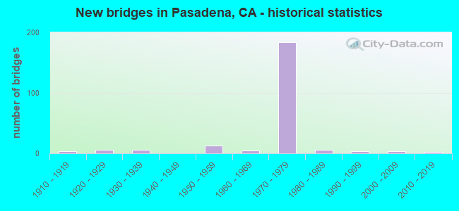
- New bridges - historical statistics
- 31910-1919
- 61920-1929
- 61930-1939
- 131950-1959
- 51960-1969
- 1841970-1979
- 61980-1989
- 41990-1999
- 32000-2009
- 22010-2019
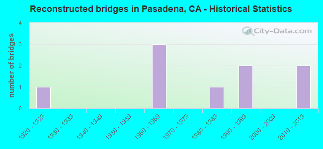
- Reconstructed bridges - Historical Statistics
- 11920-1929
- 01930-1939
- 01940-1949
- 01950-1959
- 31960-1969
- 01970-1979
- 11980-1989
- 21990-1999
- 02000-2009
- 22010-2019
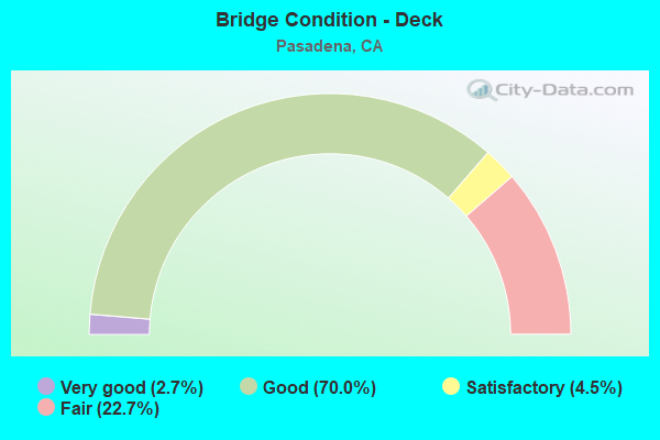
- Bridge Condition - Deck
- 2.7%Very good
- 70.0%Good
- 4.5%Satisfactory
- 22.7%Fair
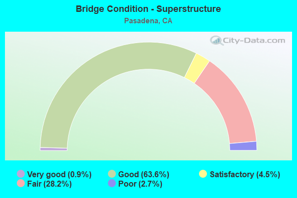
- Bridge Condition - Superstructure
- 0.9%Very good
- 63.6%Good
- 4.5%Satisfactory
- 28.2%Fair
- 2.7%Poor
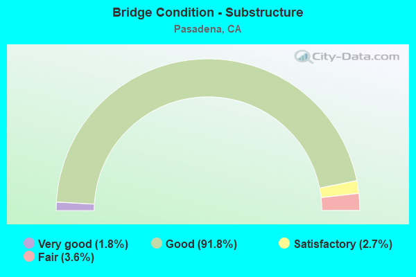
- Bridge Condition - Substructure
- 1.8%Very good
- 91.8%Good
- 2.7%Satisfactory
- 3.6%Fair
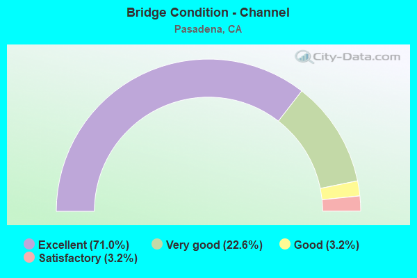
- Bridge Condition - Channel
- 71.0%Excellent
- 22.6%Very good
- 3.2%Good
- 3.2%Satisfactory
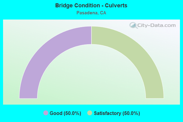
- Bridge Condition - Culverts
- 50.0%Good
- 50.0%Satisfactory
Find on map >> Show street view
Structure Number: 53C0361, Location: 0.1MI N/O FOOTHILL BLVD (Lat: 34.152386, Lng: -118.113536), Route carried "under" structure: City street , Year Built: 1976, Structure Length: 0. m, Average Daily Traffic: 21,834 (year 2012), Truck Traffic: 4%, Features Intersected: ALLEN AVE, Facility Carried by Structure: METRO
Minimum Vertical Clearance: 5.62m (18.44ft), Kilometerpoint: 0.000, Lanes under structure: 6, Material/Design: Prestressed concrete continuous, Design/Construction: Box Beam or Girders - Multiple, Length of Maximum Span: 27.7m (90.9ft)
Find on map >> Show street view
Structure Number: 53C0362, Location: 0.2MI N/O FOOTHILL BLVD (Lat: 34.152447, Lng: -118.106522), Route carried "under" structure: City street Q463, Year Built: 1976, Structure Length: 0. m, Average Daily Traffic: 2,525 (year 2012), Truck Traffic: 1%, Features Intersected: CRAIG AVE, Facility Carried by Structure: METRO
Minimum Vertical Clearance: 5.72m (18.77ft), Kilometerpoint: 0.000, Lanes under structure: 4, Material/Design: Prestressed concrete continuous, Design/Construction: Box Beam or Girders - Multiple, Length of Maximum Span: 22.5m (73.8ft)
Find on map >> Show street view
Structure Number: 53C0363, Location: 0.5MI S/O ORANGE GROVE B (Lat: 34.152489, Lng: -118.098861), Route carried "under" structure: City street L519, Year Built: 1976, Structure Length: 0. m, Average Daily Traffic: 16,840 (year 2012), Truck Traffic: 2%, Features Intersected: ALTADENA DR, Facility Carried by Structure: METRO
Minimum Vertical Clearance: 5.03m (16.50ft), Kilometerpoint: 0.000, Lanes under structure: 8, Material/Design: Prestressed concrete continuous, Design/Construction: Box Beam or Girders - Multiple, Length of Maximum Span: 29.6m (97.1ft)
Find on map >> Show street view
Structure Number: 53C0364, Location: AT I-10 FWY (Lat: 34.152506, Lng: -118.095169), Route carried "under" structure: City street , Year Built: 1976, Structure Length: 0. m, Average Daily Traffic: 8,802 (year 2010), Truck Traffic: 2%, Features Intersected: SAN GABRIEL BOULEVARD, Facility Carried by Structure: METRO
Minimum Vertical Clearance: 5.40m (17.72ft), Kilometerpoint: 0.000, Lanes under structure: 4, Material/Design: Prestressed concrete continuous, Design/Construction: Box Beam or Girders - Multiple, Length of Maximum Span: 22.7m (74.5ft)
Find on map >> Show street view
Structure Number: 53C0364, Location: AT I-10 FWY (Lat: 34.152506, Lng: -118.095169), Route carried "under" structure: City street , Year Built: 1976, Structure Length: 0. m, Average Daily Traffic: 23,735 (year 2012), Truck Traffic: 2%, Features Intersected: SAN GABRIEL BOULEVARD, Facility Carried by Structure: METRO
Minimum Vertical Clearance: 5.41m (17.75ft), Kilometerpoint: 0.000, Lanes under structure: 6, Material/Design: Prestressed concrete continuous, Design/Construction: Box Beam or Girders - Multiple, Length of Maximum Span: 22.7m (74.5ft)
Find on map >> Show street view
Structure Number: 53C0365, Location: 0.1MI N/O FOOTHILL BLVD (Lat: 34.151433, Lng: -118.090736), Route carried "under" structure: City street Q295, Year Built: 1976, Structure Length: 0. m, Average Daily Traffic: 2,214 (year 2012), Truck Traffic: 2%, Features Intersected: SUNNYSLOPE AVE, Facility Carried by Structure: METRO
Minimum Vertical Clearance: 7.92m (25.98ft), Kilometerpoint: 0.000, Lanes under structure: 4, Material/Design: Prestressed concrete continuous, Design/Construction: Box Beam or Girders - Multiple, Length of Maximum Span: 31.3m (102.7ft)
Find on map >> Show street view
Structure Number: 53C0366, Location: AT I-10 FWY (Lat: 34.150247, Lng: -118.088883), Route carried "under" structure: City street L718, Year Built: 1976, Structure Length: 0. m, Average Daily Traffic: 21,012 (year 2012), Truck Traffic: 4%, Features Intersected: FOOTHILL BLVD, Facility Carried by Structure: METRO
Minimum Vertical Clearance: 5.64m (18.50ft), Kilometerpoint: 0.000, Lanes under structure: 4, Material/Design: Prestressed concrete continuous, Design/Construction: Box Beam or Girders - Multiple, Length of Maximum Span: 39.0m (128.0ft)
Find on map >> Show street view
Structure Number: 53C1041, Location: 0.2MI W/O US-101 FWY (Lat: 34.149092, Lng: -118.166053), Route carried "under" structure: ServiceCity street , Year Built: 1925, Structure Length: 0. m, Average Daily Traffic: 4,764 (year 2010), Truck Traffic: 1%, Features Intersected: ARROYO BLVD / ARROYO S, Facility Carried by Structure: HOLLY ST
Minimum Vertical Clearance: 6.65m (21.82ft), Kilometerpoint: 0.000, Lanes on structure: 2, Lanes under structure: 2, Material/Design: Concrete, Design/Construction: Arch - Deck, Length of Maximum Span: 73.1m (239.8ft)
Find on map >> Show street view
Structure Number: 53C1731, Location: 0.1MI S/O COLORADO BLVD (Lat: 34.145125, Lng: -118.146181), Route carried "under" structure: City street L512, Year Built: 1980, Structure Length: 0. m, Average Daily Traffic: 17,434 (year 2012), Truck Traffic: 4%, Features Intersected: MARENGO AVE, Facility Carried by Structure: PASADENA PLZ POC
Minimum Vertical Clearance: 5.38m (17.65ft), Kilometerpoint: 0.000, Lanes under structure: 4, Material/Design: Concrete, Design/Construction: Stringer/Multi-beam, Length of Maximum Span: 31.4m (103.0ft)
Find on map >> Show street view
Structure Number: 53C1732, Location: 200FT W/O LOS ROBLES AVE (Lat: 34.144411, Lng: -118.142236), Route carried "under" structure: City street , Year Built: 1980, Structure Length: 0. m, Average Daily Traffic: 16,507 (year 2012), Truck Traffic: 4%, Features Intersected: GREEN ST, Facility Carried by Structure: PASADENA PLZ POC
Minimum Vertical Clearance: 5.60m (18.37ft), Kilometerpoint: 0.000, Lanes under structure: 3, Material/Design: Concrete, Design/Construction: Stringer/Multi-beam, Length of Maximum Span: 23.2m (76.1ft)
Find on map >> Show street view
Structure Number: 53C1841, Location: 0.2MI E/O SAN RAFAEL AVE (Lat: 34.144425, Lng: -118.167764), Route carried "under" structure: ServiceCity street , Year Built: 1954, Structure Length: 0. m, Average Daily Traffic: 6,125 (year 2010), Truck Traffic: 1%, Features Intersected: LINDA VISTA AVE, Facility Carried by Structure: COLORADO BLVD
Minimum Vertical Clearance: 4.52m (14.83ft), Kilometerpoint: 0.000, Lanes on structure: 2, Lanes under structure: 2, Material/Design: Concrete, Design/Construction: Box Beam or Girders - Multiple, Length of Maximum Span: 15.5m (50.9ft)