Bridge Statistics for Pasadena, California (CA)
Condition, Traffic, Stress, Structural Evaluation, Project Costs
- National Bridge Inventory (NBI) Statistics
- 232Number of bridges
- 3,068ft / 935mTotal length
- $10,758,000Total costs
- 13,865,314Total average daily traffic
- 685,839Total average daily truck traffic
- National Bridge Inventory (NBI) Registered Bridges for Pasadena
- No street view available for this location
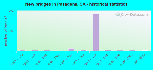
- New bridges - historical statistics
- 31910-1919
- 61920-1929
- 61930-1939
- 131950-1959
- 51960-1969
- 1841970-1979
- 61980-1989
- 41990-1999
- 32000-2009
- 22010-2019
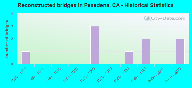
- Reconstructed bridges - Historical Statistics
- 11920-1929
- 01930-1939
- 01940-1949
- 01950-1959
- 31960-1969
- 01970-1979
- 11980-1989
- 21990-1999
- 02000-2009
- 22010-2019
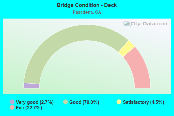
- Bridge Condition - Deck
- 2.7%Very good
- 70.0%Good
- 4.5%Satisfactory
- 22.7%Fair
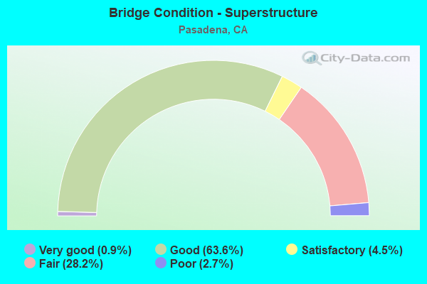
- Bridge Condition - Superstructure
- 0.9%Very good
- 63.6%Good
- 4.5%Satisfactory
- 28.2%Fair
- 2.7%Poor
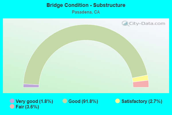
- Bridge Condition - Substructure
- 1.8%Very good
- 91.8%Good
- 2.7%Satisfactory
- 3.6%Fair
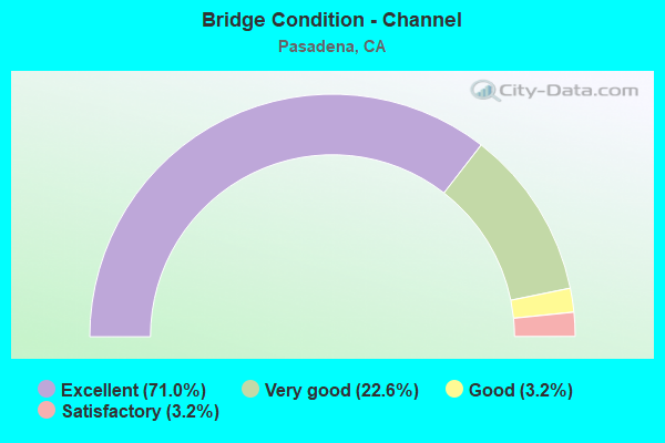
- Bridge Condition - Channel
- 71.0%Excellent
- 22.6%Very good
- 3.2%Good
- 3.2%Satisfactory
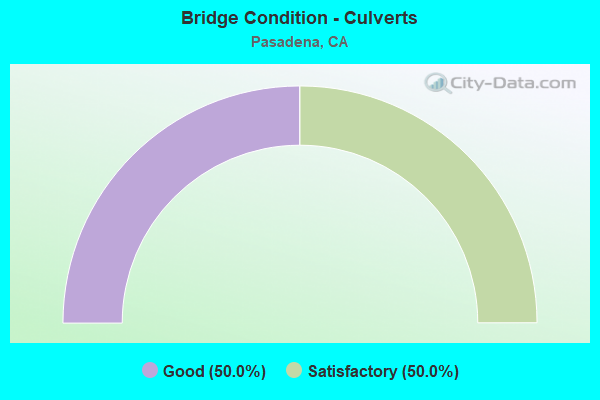
- Bridge Condition - Culverts
- 50.0%Good
- 50.0%Satisfactory
Find on map >> Show street view
Structure Number: 53C0261, Location: 200FT N/O I-405 FWY (Lat: 33.840161, Lng: -118.262947), Route carried "on" structure: City street L044, Year Built: 1962, Year Reconstructed: 1974, Status: Open, Structure Length: 7.62m (25.00ft), Average Daily Traffic: 24,100 (year 2012), Truck Traffic: 4%, Average Future Daily Traffic: 28,900 (year 2038), Design Load: HS 20, Features Intersected: DOMINGUEZ CHAN, Facility Carried by Structure: AVALON BLVD
Minimum Vertical Clearance: 30.47m (99.97ft), Kilometerpoint: 0.000, Lanes on structure: 7, Owner: City or Municipal Highway Agency, Approaching Roadway Width: 23.5m (77.1ft), Skew: 23 degrees, Material/Design: Concrete continuous, Design/Construction: Tee Beam, Number Of Spans In Main Unit: 6, Length of Maximum Span: 13.4m (44.0ft), Curb or Sidewalk Widths: Left: 0.0m, Right: 1.6m (5.2ft), Curb-To-Curb Width: 24.2m (79.4ft), Out-to-Out Width: 31.2m (102.4ft)
Condition: Deck: Fair, Superstructure: Good, Substructure: Good, Channel: Very good, Operating Rating: 52.8 metric tons, Method Used To Determine Operating Rating: Load Factor (LF), Inventory Rating: 31.4 metric tons, Method Used To Determine Inventory Rating: Load Factor (LF), Structural Evaluation: Better than present minimum criteria, Deck Geometry: High priority of replacement, Waterway Adequacy: Superior to present desirable criteria, Approach Roadway Alignment: Equal to present minimum criteria, Designated Inspection Frequency: Every 24 months, Underwater Inspection Frequency: Every 60 months, Inspection Date: June 2020, Underwater Inspection Date: May 2021, Deck Structure Type: Concrete Cast-file-Place
Find on map >> Show street view
Structure Number: 53C0264, Location: 0.4MI S/O LINCOLN BLVD (Lat: 34.158261, Lng: -118.161814), Route carried "on" structure: City street Q304, Year Built: 1989, Status: Open, Structure Length: 12.24m (40.16ft), Average Daily Traffic: 755 (year 2012), Truck Traffic: 2%, Average Future Daily Traffic: 831 (year 2040), Design Load: HS 20+Mod, Features Intersected: SECO ST, Facility Carried by Structure: PROSPECT BLVD
Minimum Vertical Clearance: 30.47m (99.97ft), Kilometerpoint: 0.000, Lanes on structure: 2, Lanes under structure: 4, Owner: City or Municipal Highway Agency, Approaching Roadway Width: 10.1m (33.1ft), Skew: 9 degrees, Material/Design: Prestressed concrete continuous, Design/Construction: Box Beam or Girders - Multiple, Number Of Spans In Main Unit: 4, Length of Maximum Span: 35.1m (115.2ft), Curb or Sidewalk Widths: Left: 1.6m (5.2ft), Right: 1.6m (5.2ft), Curb-To-Curb Width: 10.3m (33.8ft), Out-to-Out Width: 14.1m (46.3ft)
Condition: Deck: Very good, Superstructure: Good, Substructure: Good, Operating Rating: 73.2 metric tons, Method Used To Determine Operating Rating: Load Factor (LF), Inventory Rating: 41.1 metric tons, Method Used To Determine Inventory Rating: Load Factor (LF), Structural Evaluation: Better than present minimum criteria, Deck Geometry: Equal to present minimum criteria, Underclear: High priority of corrective action, Approach Roadway Alignment: Equal to present minimum criteria, Designated Inspection Frequency: Every 24 months, Inspection Date: July 2020, Deck Structure Type: Concrete Cast-file-Place
Find on map >> Show street view
Structure Number: 53C0351, Location: AT OLYMPIC BLVD (Lat: 34.056411, Lng: -118.413456), Route carried "on" structure: City street , Year Built: 1963, Status: Open, Structure Length: 7.19m (23.59ft), Average Daily Traffic: 30,223 (year 2018), Truck Traffic: 3%, Average Future Daily Traffic: 40,940 (year 2040), Design Load: HS 20, Features Intersected: OLYMPIC BLVD, Facility Carried by Structure: AVENUE OF THE STAR
Minimum Vertical Clearance: 30+ m (98+ ft), Kilometerpoint: 0.000, Lanes on structure: 7, Lanes under structure: 8, Owner: City or Municipal Highway Agency, Approaching Roadway Width: 24.2m (79.4ft), Skew: 23 degrees, Material/Design: Concrete continuous, Design/Construction: Box Beam or Girders - Multiple, Number Of Spans In Main Unit: 3, Length of Maximum Span: 41.5m (136.2ft), Curb or Sidewalk Widths: Left: 2.3m (7.5ft), Right: 2.3m (7.5ft), Curb-To-Curb Width: 27.2m (89.2ft), Out-to-Out Width: 35.2m (115.5ft)
Condition: Deck: Good, Superstructure: Poor, Substructure: Good, Operating Rating: 86.5 metric tons, Method Used To Determine Operating Rating: Load Factor (LF), Inventory Rating: 52.2 metric tons, Method Used To Determine Inventory Rating: Load Factor (LF), Structural Evaluation: Meets minimum limits, Deck Geometry: Somewhat better than minimum adequacy, Underclear: Meets minimum limits, Approach Roadway Alignment: Equal to present desirable criteria, Length Of Structure Improvement: 7.19m (23.59ft), Designated Inspection Frequency: Every 24 months, Inspection Date: June 2020, Bridge Improvement Cost: $2,531,000, Roadway Improvement Cost: $506,000, Total Project Cost: $4,252,000 ( Estimate for 2019), Deck Structure Type: Concrete Cast-file-Place, Wearing Surface/Protective System: Wearing Surface: Bituminous
Find on map >> Show street view
Structure Number: 53C0367, Location: 0.1MI E/O FAIR OAKS AVE (Lat: 34.149419, Lng: -118.147061), Route carried "on" structure: City street , Year Built: 1976, Status: Open, Structure Length: 1.12m (3.67ft), Average Daily Traffic: 19,326 (year 2012), Truck Traffic: 2%, Average Future Daily Traffic: 23,191 (year 2040), Design Load: HS 20+Mod, Features Intersected: METRO, Facility Carried by Structure: WALNUT ST
Minimum Vertical Clearance: 30.47m (99.97ft), Kilometerpoint: 0.000, Lanes on structure: 4, Owner: City or Municipal Highway Agency, Approaching Roadway Width: 18.3m (60.0ft), Skew: 2 degrees, Material/Design: Concrete, Design/Construction: Slab, Number Of Spans In Main Unit: 1, Length of Maximum Span: 9.8m (32.2ft), Curb or Sidewalk Widths: Left: 3.1m (10.2ft), Right: 3.1m (10.2ft), Curb-To-Curb Width: 18.2m (59.7ft), Out-to-Out Width: 25.1m (82.3ft)
Condition: Deck: Fair, Superstructure: Fair, Substructure: Good, Operating Rating: 93.0 metric tons, Method Used To Determine Operating Rating: Load Factor (LF), Inventory Rating: 55.7 metric tons, Method Used To Determine Inventory Rating: Load Factor (LF), Structural Evaluation: Somewhat better than minimum adequacy, Deck Geometry: Somewhat better than minimum adequacy, Underclear: Somewhat better than minimum adequacy, Approach Roadway Alignment: Equal to present desirable criteria, Designated Inspection Frequency: Every 24 months, Inspection Date: July 2020, Deck Structure Type: Concrete Cast-file-Place
Find on map >> Show street view
Structure Number: 53C0643, Location: 10MI N/O FOOTHILL BLVD (Lat: 34.283597, Lng: -118.197608), Route carried "on" structure: County highway L624, Year Built: 1958, Status: Open, Structure Length: 11.70m (38.39ft), Average Daily Traffic: 510 (year 2012), Truck Traffic: 1%, Average Future Daily Traffic: 561 (year 2041), Design Load: HS 20, Features Intersected: BIG TUJUNGA CYN-E XING, Facility Carried by Structure: BIG TUJUNGA CYN RD
Minimum Vertical Clearance: 30.47m (99.97ft), Kilometerpoint: 0.000, Lanes on structure: 2, Owner: County Highway Agency, Approaching Roadway Width: 7.9m (25.9ft), Material/Design: Concrete, Design/Construction: Arch - Deck, Number Of Spans In Main Unit: 1, Number Of Approach Spans: 5, Length of Maximum Span: 82.0m (269.0ft), Curb or Sidewalk Widths: Left: 0.9m (3.0ft), Right: 0.9m (3.0ft), Curb-To-Curb Width: 8.4m (27.6ft), Out-to-Out Width: 11.9m (39.0ft)
Condition: Deck: Good, Superstructure: Satisfactory, Substructure: Good, Channel: Satisfactory, Operating Rating: 46.7 metric tons, Method Used To Determine Operating Rating: Load Factor (LF), Inventory Rating: 27.9 metric tons, Method Used To Determine Inventory Rating: Load Factor (LF), Structural Evaluation: Equal to present minimum criteria, Deck Geometry: Somewhat better than minimum adequacy, Waterway Adequacy: Better than present minimum criteria, Approach Roadway Alignment: Equal to present minimum criteria, Designated Inspection Frequency: Every 24 months, Inspection Date: May 2020, Deck Structure Type: Concrete Cast-file-Place
Find on map >> Show street view
Structure Number: 53C0657L, Location: 0.5MI W/O SIERRA MADRE VL (Lat: 34.161619, Lng: -118.089675), Route carried "on" structure: City street L514, Year Built: 1958, Status: Open, Structure Length: 0.83m (2.72ft), Average Daily Traffic: 7,604 (year 2012), Truck Traffic: 1%, Average Future Daily Traffic: 8,745 (year 2040), Design Load: HS 20, Features Intersected: EATON WASH, Facility Carried by Structure: SIERRA MDR BLVD W
Minimum Vertical Clearance: 30.47m (99.97ft), Kilometerpoint: 0.000, Lanes on structure: 3, Owner: City or Municipal Highway Agency, Approaching Roadway Width: 12.1m (39.7ft), Skew: 1 degrees, Material/Design: Concrete, Design/Construction: Slab, Number Of Spans In Main Unit: 1, Length of Maximum Span: 7.7m (25.3ft), Curb or Sidewalk Widths: Left: 1.5m (4.9ft), Right: 0.6m (2.0ft), Curb-To-Curb Width: 11.9m (39.0ft), Out-to-Out Width: 14.6m (47.9ft)
Condition: Deck: Very good, Superstructure: Good, Substructure: Good, Channel: Excellent, Operating Rating: 53.1 metric tons, Method Used To Determine Operating Rating: Load Factor (LF), Inventory Rating: 31.8 metric tons, Method Used To Determine Inventory Rating: Load Factor (LF), Structural Evaluation: Better than present minimum criteria, Deck Geometry: High priority of corrective action, Waterway Adequacy: Superior to present desirable criteria, Approach Roadway Alignment: Equal to present desirable criteria, Designated Inspection Frequency: Every 24 months, Inspection Date: July 2020, Deck Structure Type: Concrete Cast-file-Place
Find on map >> Show street view
Structure Number: 53C0657R, Location: 0.5MI W/O SIERRA MDRE VLL (Lat: 34.161289, Lng: -118.089569), Route carried "on" structure: City street L514, Year Built: 1958, Status: Open, Structure Length: 0.87m (2.85ft), Average Daily Traffic: 8,699 (year 2012), Truck Traffic: 1%, Average Future Daily Traffic: 10,004 (year 2040), Design Load: HS 20, Features Intersected: EATON WASH, Facility Carried by Structure: SIERRA MDRE BLVD E
Minimum Vertical Clearance: 30.47m (99.97ft), Kilometerpoint: 0.000, Lanes on structure: 3, Owner: City or Municipal Highway Agency, Approaching Roadway Width: 14.6m (47.9ft), Skew: 1 degrees, Material/Design: Concrete, Design/Construction: Slab, Number Of Spans In Main Unit: 1, Length of Maximum Span: 7.9m (25.9ft), Curb or Sidewalk Widths: Left: 0.5m (1.6ft), Right: 1.4m (4.6ft), Curb-To-Curb Width: 14.5m (47.6ft), Out-to-Out Width: 16.9m (55.4ft)
Condition: Deck: Good, Superstructure: Good, Substructure: Very good, Channel: Excellent, Operating Rating: 41.5 metric tons, Method Used To Determine Operating Rating: Load Factor (LF), Inventory Rating: 24.9 metric tons, Method Used To Determine Inventory Rating: Load Factor (LF), Structural Evaluation: Equal to present minimum criteria, Deck Geometry: Somewhat better than minimum adequacy, Waterway Adequacy: Superior to present desirable criteria, Approach Roadway Alignment: Equal to present desirable criteria, Designated Inspection Frequency: Every 24 months, Inspection Date: July 2020, Deck Structure Type: Concrete Cast-file-Place
Find on map >> Show street view
Structure Number: 53C0755, Location: 0.8MI W/O FAIR OAKS AVE (Lat: 34.174456, Lng: -118.170753), Route carried "on" structure: City street Q295, Year Built: 1939, Status: Open, Structure Length: 2.52m (8.27ft), Average Daily Traffic: 1,262 (year 2012), Truck Traffic: 1%, Average Future Daily Traffic: 1,388 (year 2040), Features Intersected: ARROYO SECO CHAN, Facility Carried by Structure: WASHINGTON BLVD
Minimum Vertical Clearance: 30.47m (99.97ft), Kilometerpoint: 0.000, Lanes on structure: 2, Owner: City or Municipal Highway Agency, Approaching Roadway Width: 12.2m (40.0ft), Material/Design: Concrete, Design/Construction: Slab, Number Of Spans In Main Unit: 1, Length of Maximum Span: 22.9m (75.1ft), Curb or Sidewalk Widths: Left: 1.6m (5.2ft), Right: 1.6m (5.2ft), Curb-To-Curb Width: 12.2m (40.0ft), Out-to-Out Width: 16.1m (52.8ft)
Condition: Deck: Good, Superstructure: Good, Substructure: Good, Channel: Excellent, Operating Rating: 30.8 metric tons, Method Used To Determine Operating Rating: Load Factor (LF), Inventory Rating: 18.5 metric tons, Method Used To Determine Inventory Rating: Load Factor (LF), Structural Evaluation: Somewhat better than minimum adequacy, Deck Geometry: Better than present minimum criteria, Waterway Adequacy: Superior to present desirable criteria, Approach Roadway Alignment: Equal to present desirable criteria, Designated Inspection Frequency: Every 24 months, Inspection Date: July 2020, Deck Structure Type: Concrete Cast-file-Place
Find on map >> Show street view
Structure Number: 53C0756, Location: 0.1MI W/O ARROYO BLVD (Lat: 34.155994, Lng: -118.168106), Route carried "on" structure: City street Q488, Year Built: 1939, Status: Open, Structure Length: 2.03m (6.66ft), Average Daily Traffic: 1,793 (year 2012), Truck Traffic: 1%, Average Future Daily Traffic: 1,972 (year 2040), Features Intersected: ARROYO SECO CHAN, Facility Carried by Structure: SECO ST
Minimum Vertical Clearance: 30.47m (99.97ft), Kilometerpoint: 0.000, Lanes on structure: 4, Owner: City or Municipal Highway Agency, Approaching Roadway Width: 18.3m (60.0ft), Material/Design: Concrete, Design/Construction: Slab, Number Of Spans In Main Unit: 1, Length of Maximum Span: 18.3m (60.0ft), Curb or Sidewalk Widths: Left: 1.6m (5.2ft), Right: 1.6m (5.2ft), Curb-To-Curb Width: 18.2m (59.7ft), Out-to-Out Width: 22.2m (72.8ft)
Condition: Deck: Good, Superstructure: Good, Substructure: Satisfactory, Channel: Excellent, Operating Rating: 33.7 metric tons, Method Used To Determine Operating Rating: Load Factor (LF), Inventory Rating: 20.4 metric tons, Method Used To Determine Inventory Rating: Load Factor (LF), Structural Evaluation: Somewhat better than minimum adequacy, Deck Geometry: Somewhat better than minimum adequacy, Waterway Adequacy: Superior to present desirable criteria, Approach Roadway Alignment: Better than present minimum criteria, Designated Inspection Frequency: Every 24 months, Inspection Date: July 2020, Deck Structure Type: Concrete Cast-file-Place
Find on map >> Show street view
Structure Number: 53C0757, Location: 100FT W/O ARROYO BLVD (Lat: 34.126094, Lng: -118.166042), Route carried "on" structure: City street Q459, Year Built: 1922, Status: Open, Structure Length: 7.88m (25.85ft), Average Daily Traffic: 381 (year 2012), Truck Traffic: 2%, Average Future Daily Traffic: 381 (year 2040), Features Intersected: ARROYO SECO CHAN, Facility Carried by Structure: SAN RAFAEL AVE
Minimum Vertical Clearance: 30.47m (99.97ft), Kilometerpoint: 0.000, Lanes on structure: 2, Owner: City or Municipal Highway Agency, Approaching Roadway Width: 6.1m (20.0ft), Material/Design: Concrete, Design/Construction: Arch - Deck, Number Of Spans In Main Unit: 3, Number Of Approach Spans: 5, Length of Maximum Span: 47.2m (154.9ft), Curb or Sidewalk Widths: Left: 1.6m (5.2ft), Right: 1.7m (5.6ft), Curb-To-Curb Width: 5.9m (19.4ft), Out-to-Out Width: 9.9m (32.5ft)
Condition: Deck: Good, Superstructure: Good, Substructure: Good, Channel: Excellent, Operating Rating: 99.8 metric tons, Method Used To Determine Operating Rating: Load Factor (LF), Inventory Rating: 68.7 metric tons, Method Used To Determine Inventory Rating: Load Factor (LF), Structural Evaluation: Better than present minimum criteria, Deck Geometry: High priority of corrective action, Waterway Adequacy: Superior to present desirable criteria, Approach Roadway Alignment: Meets minimum limits, Designated Inspection Frequency: Every 24 months, Inspection Date: August 2020, Deck Structure Type: Concrete Cast-file-Place, Wearing Surface/Protective System: Wearing Surface: Bituminous
Find on map >> Show street view
Structure Number: 53C0758, Location: 0.1MI N/O SR-134 FWY (Lat: 34.146586, Lng: -118.163856), Route carried "on" structure: City street , Year Built: 1927, Status: Open, Structure Length: 3.53m (11.58ft), Average Daily Traffic: 1,965 (year 2012), Truck Traffic: 1%, Average Future Daily Traffic: 2,162 (year 2040), Features Intersected: ARROYO SECO CHAN, Facility Carried by Structure: ARROYO BLVD
Minimum Vertical Clearance: 30.47m (99.97ft), Kilometerpoint: 0.000, Lanes on structure: 2, Owner: City or Municipal Highway Agency, Approaching Roadway Width: 9.1m (29.9ft), Material/Design: Concrete, Design/Construction: Arch - Deck, Number Of Spans In Main Unit: 5, Length of Maximum Span: 9.4m (30.8ft), Curb or Sidewalk Widths: Left: 0.0m, Right: 1.7m (5.6ft), Curb-To-Curb Width: 8.9m (29.2ft), Out-to-Out Width: 11.3m (37.1ft)
Condition: Deck: Satisfactory, Superstructure: Satisfactory, Substructure: Good, Channel: Excellent, Operating Rating: 25.9 metric tons, Method Used To Determine Operating Rating: Field evaluation and documented engineering judgment, Inventory Rating: 15.6 metric tons, Method Used To Determine Inventory Rating: Field evaluation and documented engineering judgment, Structural Evaluation: Meets minimum limits, Deck Geometry: Somewhat better than minimum adequacy, Waterway Adequacy: Superior to present desirable criteria, Approach Roadway Alignment: High priority of corrective action, Designated Inspection Frequency: Every 24 months, Inspection Date: July 2020, Deck Structure Type: Concrete Cast-file-Place
Find on map >> Show street view
Structure Number: 53C0759, Location: 100FT W/O ARROYO BLVD (Lat: 34.133850, Lng: -118.167492), Route carried "on" structure: City street , Year Built: 1914, Year Reconstructed: 2018, Status: Open, Structure Length: 9.57m (31.40ft), Average Daily Traffic: 3,570 (year 2012), Truck Traffic: 1%, Average Future Daily Traffic: 3,927 (year 2040), Design Load: HL 93, Features Intersected: ARROYO SECO CHAN, Facility Carried by Structure: LA LOMA RD
Minimum Vertical Clearance: 30.47m (99.97ft), Kilometerpoint: 0.000, Lanes on structure: 2, Owner: City or Municipal Highway Agency, Approaching Roadway Width: 12.2m (40.0ft), Material/Design: Prestressed concrete continuous, Design/Construction: Box Beam or Girders - Single/Spread, Number Of Spans In Main Unit: 4, Length of Maximum Span: 30.8m (101.0ft), Curb or Sidewalk Widths: Left: 1.6m (5.2ft), Right: 1.6m (5.2ft), Curb-To-Curb Width: 9.1m (29.9ft), Out-to-Out Width: 13.4m (44.0ft)
Condition: Deck: Very good, Superstructure: Very good, Substructure: Very good, Channel: Excellent, Operating Rating: 42.1 metric tons, Method Used To Determine Operating Rating: Assigned ratings based on Load and Resistance Factor Design (LRFD) reported by rating factor (RF) using HL93 loadings, Inventory Rating: 32.4 metric tons, Method Used To Determine Inventory Rating: Assigned ratings based on Load and Resistance Factor Design (LRFD) reported by rating factor (RF) using HL93 loadings, Structural Evaluation: Equal to present desirable criteria, Deck Geometry: Meets minimum limits, Waterway Adequacy: Superior to present desirable criteria, Approach Roadway Alignment: Meets minimum limits, Designated Inspection Frequency: Every 24 months, Inspection Date: August 2020, Deck Structure Type: Concrete Cast-file-Place
Find on map >> Show street view
Structure Number: 53C0765, Location: E/O SAN GABRIEL BLVD (Lat: 34.149878, Lng: -118.088817), Route carried "on" structure: City street L718, Year Built: 1972, Status: Open, Structure Length: 1.60m (5.25ft), Average Daily Traffic: 21,012 (year 2012), Truck Traffic: 4%, Average Future Daily Traffic: 25,214 (year 2038), Features Intersected: EATON WASH, Facility Carried by Structure: FOOTHILL BLVD
Minimum Vertical Clearance: 5.00m (16.40ft), Kilometerpoint: 0.000, Lanes on structure: 4, Owner: City or Municipal Highway Agency, Approaching Roadway Width: 23.3m (76.4ft), Skew: 24 degrees, Material/Design: Concrete, Design/Construction: Slab, Number Of Spans In Main Unit: 1, Length of Maximum Span: 13.4m (44.0ft), Curb or Sidewalk Widths: Left: 2.5m (8.2ft), Right: 2.4m (7.9ft), Curb-To-Curb Width: 22.1m (72.5ft), Out-to-Out Width: 30.7m (100.7ft)
Condition: Deck: Good, Superstructure: Satisfactory, Substructure: Satisfactory, Channel: Excellent, Operating Rating: 54.1 metric tons, Method Used To Determine Operating Rating: Field evaluation and documented engineering judgment, Inventory Rating: 32.4 metric tons, Method Used To Determine Inventory Rating: Field evaluation and documented engineering judgment, Structural Evaluation: Equal to present minimum criteria, Deck Geometry: Better than present minimum criteria, Waterway Adequacy: Superior to present desirable criteria, Approach Roadway Alignment: Equal to present desirable criteria, Designated Inspection Frequency: Every 48 months, Inspection Date: June 2018
Find on map >> Show street view
Structure Number: 53C0785L, Location: 1.0MI N/O SIERRA MADRE BL (Lat: 34.174217, Lng: -118.095500), Route carried "on" structure: City street L521, Year Built: 1962, Status: Open, Structure Length: 4.60m (15.09ft), Average Daily Traffic: 8,623 (year 2012), Truck Traffic: 1%, Average Future Daily Traffic: 9,917 (year 2040), Design Load: HS 20, Features Intersected: EATON WASH, Facility Carried by Structure: NEW YORK DR WB
Minimum Vertical Clearance: 30.47m (99.97ft), Kilometerpoint: 0.000, Lanes on structure: 2, Owner: City or Municipal Highway Agency, Approaching Roadway Width: 10.0m (32.8ft), Skew: 4 degrees, Material/Design: Steel, Design/Construction: Stringer/Multi-beam, Number Of Spans In Main Unit: 2, Length of Maximum Span: 22.9m (75.1ft), Curb or Sidewalk Widths: Left: 1.5m (4.9ft), Right: 0.7m (2.3ft), Curb-To-Curb Width: 10.1m (33.1ft), Out-to-Out Width: 12.9m (42.3ft)
Condition: Deck: Good, Superstructure: Fair, Substructure: Good, Channel: Excellent, Operating Rating: 48.6 metric tons, Method Used To Determine Operating Rating: Load Factor (LF), Inventory Rating: 29.2 metric tons, Method Used To Determine Inventory Rating: Load Factor (LF), Structural Evaluation: Somewhat better than minimum adequacy, Deck Geometry: Somewhat better than minimum adequacy, Waterway Adequacy: Superior to present desirable criteria, Approach Roadway Alignment: Equal to present desirable criteria, Designated Inspection Frequency: Every 24 months, Inspection Date: July 2020, Deck Structure Type: Concrete Cast-file-Place
Find on map >> Show street view
Structure Number: 53C0785R, Location: 1.0MI NW/O SIERRA MADRE (Lat: 34.174036, Lng: -118.095450), Route carried "on" structure: City street L521, Year Built: 1962, Status: Open, Structure Length: 4.70m (15.42ft), Average Daily Traffic: 7,518 (year 2012), Truck Traffic: 1%, Average Future Daily Traffic: 8,646 (year 2040), Design Load: HS 20, Features Intersected: EATON WASH, Facility Carried by Structure: NEW YORK DR EB
Minimum Vertical Clearance: 30.47m (99.97ft), Kilometerpoint: 0.000, Lanes on structure: 2, Owner: City or Municipal Highway Agency, Approaching Roadway Width: 9.8m (32.2ft), Skew: 9 degrees, Material/Design: Steel, Design/Construction: Stringer/Multi-beam, Number Of Spans In Main Unit: 2, Length of Maximum Span: 22.9m (75.1ft), Curb or Sidewalk Widths: Left: 0.7m (2.3ft), Right: 1.5m (4.9ft), Curb-To-Curb Width: 10.0m (32.8ft), Out-to-Out Width: 12.9m (42.3ft)
Condition: Deck: Good, Superstructure: Fair, Substructure: Good, Channel: Excellent, Operating Rating: 48.6 metric tons, Method Used To Determine Operating Rating: Load Factor (LF), Inventory Rating: 29.2 metric tons, Method Used To Determine Inventory Rating: Load Factor (LF), Structural Evaluation: Somewhat better than minimum adequacy, Deck Geometry: Meets minimum limits, Waterway Adequacy: Superior to present desirable criteria, Approach Roadway Alignment: Equal to present desirable criteria, Designated Inspection Frequency: Every 24 months, Inspection Date: July 2020, Deck Structure Type: Concrete Cast-file-Place
Find on map >> Show street view
Structure Number: 53C0794, Location: 0.4MI W/O SRRA MADRE VLLA (Lat: 34.158425, Lng: -118.087747), Route carried "on" structure: City street L508, Year Built: 1954, Status: Open, Structure Length: 1.23m (4.04ft), Average Daily Traffic: 8,299 (year 2012), Truck Traffic: 1%, Average Future Daily Traffic: 9,544 (year 2040), Design Load: HS 20, Features Intersected: EATON WASH, Facility Carried by Structure: ORANGE GROVE AVE
Minimum Vertical Clearance: 30.47m (99.97ft), Kilometerpoint: 0.000, Lanes on structure: 4, Owner: City or Municipal Highway Agency, Approaching Roadway Width: 18.3m (60.0ft), Skew: 1 degrees, Material/Design: Concrete, Design/Construction: Slab, Number Of Spans In Main Unit: 1, Length of Maximum Span: 9.3m (30.5ft), Curb or Sidewalk Widths: Left: 1.9m (6.2ft), Right: 1.9m (6.2ft), Curb-To-Curb Width: 18.3m (60.0ft), Out-to-Out Width: 22.6m (74.1ft)
Condition: Deck: Good, Superstructure: Good, Substructure: Good, Channel: Excellent, Operating Rating: 55.7 metric tons, Method Used To Determine Operating Rating: Load Factor (LF), Inventory Rating: 33.4 metric tons, Method Used To Determine Inventory Rating: Load Factor (LF), Structural Evaluation: Better than present minimum criteria, Deck Geometry: Somewhat better than minimum adequacy, Waterway Adequacy: Superior to present desirable criteria, Approach Roadway Alignment: Equal to present desirable criteria, Designated Inspection Frequency: Every 48 months, Inspection Date: July 2020, Deck Structure Type: Concrete Cast-file-Place, Wearing Surface/Protective System: Wearing Surface: Bituminous
Find on map >> Show street view
Structure Number: 53C0796, Location: 0.1MI N/O FOOTHILL BLVD (Lat: 34.150864, Lng: -118.088700), Route carried "on" structure: City street Q846, Year Built: 1972, Status: Open, Structure Length: 1.60m (5.25ft), Average Daily Traffic: 1,530 (year 2012), Truck Traffic: 2%, Average Future Daily Traffic: 1,683 (year 2040), Features Intersected: EATON WASH, Facility Carried by Structure: MAPLE ST
Minimum Vertical Clearance: 30.47m (99.97ft), Kilometerpoint: 0.000, Lanes on structure: 2, Owner: City or Municipal Highway Agency, Approaching Roadway Width: 10.2m (33.5ft), Skew: 4 degrees, Material/Design: Concrete, Design/Construction: Culvert, Number Of Spans In Main Unit: 1, Length of Maximum Span: 13.4m (44.0ft), Curb or Sidewalk Widths: Left: 3.1m (10.2ft), Right: 0.1m (0.3ft), Curb-To-Curb Width: 10.2m (33.5ft), Out-to-Out Width: 28.0m (91.9ft)
Condition: Channel: Excellent, Culverts: Good, Operating Rating: 54.1 metric tons, Method Used To Determine Operating Rating: Field evaluation and documented engineering judgment, Inventory Rating: 32.4 metric tons, Method Used To Determine Inventory Rating: Field evaluation and documented engineering judgment, Structural Evaluation: Better than present minimum criteria, Deck Geometry: Somewhat better than minimum adequacy, Waterway Adequacy: Superior to present desirable criteria, Approach Roadway Alignment: Equal to present desirable criteria, Designated Inspection Frequency: Every 48 months, Inspection Date: July 2020
Find on map >> Show street view
Structure Number: 53C0863, Location: 0.3MI N/O SR-110 FWY (Lat: 34.124769, Lng: -118.150136), Route carried "on" structure: City street , Year Built: 1972, Status: Open, Structure Length: 5.17m (16.96ft), Average Daily Traffic: 26,509 (year 2012), Truck Traffic: 4%, Average Future Daily Traffic: 31,811 (year 2040), Design Load: HS 20, Features Intersected: METRO, Facility Carried by Structure: FAIR OAKS AVE
Minimum Vertical Clearance: 30.47m (99.97ft), Kilometerpoint: 0.000, Lanes on structure: 4, Owner: City or Municipal Highway Agency, Approaching Roadway Width: 21.7m (71.2ft), Skew: 25 degrees, Material/Design: Concrete continuous, Design/Construction: Tee Beam, Number Of Spans In Main Unit: 3, Length of Maximum Span: 19.8m (65.0ft), Curb or Sidewalk Widths: Left: 2.8m (9.2ft), Right: 2.7m (8.9ft), Curb-To-Curb Width: 21.7m (71.2ft), Out-to-Out Width: 30.5m (100.1ft)
Condition: Deck: Good, Superstructure: Good, Substructure: Good, Operating Rating: 44.7 metric tons, Method Used To Determine Operating Rating: Load Factor (LF), Inventory Rating: 26.9 metric tons, Method Used To Determine Inventory Rating: Load Factor (LF), Structural Evaluation: Equal to present minimum criteria, Deck Geometry: Superior to present desirable criteria, Underclear: High priority of corrective action, Approach Roadway Alignment: Better than present minimum criteria, Designated Inspection Frequency: Every 24 months, Inspection Date: July 2020, Deck Structure Type: Concrete Cast-file-Place
Find on map >> Show street view
Structure Number: 53C1041, Location: 0.2MI W/O US-101 FWY (Lat: 34.149092, Lng: -118.166053), Route carried "on" structure: City street , Year Built: 1925, Status: Open, Structure Length: 12.19m (39.99ft), Average Daily Traffic: 7,453 (year 2012), Truck Traffic: 2%, Average Future Daily Traffic: 8,571 (year 2040), Features Intersected: ARROYO BLVD / ARROYO S, Facility Carried by Structure: HOLLY ST
Minimum Vertical Clearance: 30.47m (99.97ft), Kilometerpoint: 0.000, Lanes on structure: 2, Lanes under structure: 2, Owner: City or Municipal Highway Agency, Approaching Roadway Width: 9.4m (30.8ft), Skew: 4 degrees, Material/Design: Concrete, Design/Construction: Arch - Deck, Number Of Spans In Main Unit: 1, Number Of Approach Spans: 5, Length of Maximum Span: 73.1m (239.8ft), Curb or Sidewalk Widths: Left: 2.0m (6.6ft), Right: 2.0m (6.6ft), Curb-To-Curb Width: 9.2m (30.2ft), Out-to-Out Width: 13.8m (45.3ft)
Condition: Deck: Satisfactory, Superstructure: Poor, Substructure: Fair, Channel: Excellent, Operating Rating: 29.5 metric tons, Method Used To Determine Operating Rating: Load Factor (LF), Inventory Rating: 17.5 metric tons, Method Used To Determine Inventory Rating: Load Factor (LF), Structural Evaluation: Meets minimum limits, Deck Geometry: Meets minimum limits, Underclear: Superior to present desirable criteria, Waterway Adequacy: Superior to present desirable criteria, Approach Roadway Alignment: Equal to present minimum criteria, Designated Inspection Frequency: Every 24 months, Inspection Date: July 2020, Bridge Improvement Cost: $3,866,000, Roadway Improvement Cost: $773,000, Total Project Cost: $6,496,000 ( Estimate for 2017), Deck Structure Type: Concrete Cast-file-Place, Wearing Surface/Protective System: Wearing Surface: Bituminous
Find on map >> Show street view
Structure Number: 53C143, Location: 0.1MI E/O EL MONTE AVE (Lat: 34.120144, Lng: -118.037389), Route carried "on" structure: City street , Year Built: 1955, Status: Open, Structure Length: 1.15m (3.77ft), Average Daily Traffic: 1,020 (year 2012), Truck Traffic: 2%, Average Future Daily Traffic: 1,122 (year 2041), Design Load: HS 20, Features Intersected: ARCADIA WASH, Facility Carried by Structure: NORMAN AVE
Minimum Vertical Clearance: 30+ m (98+ ft), Kilometerpoint: 0.000, Lanes on structure: 2, Owner: City or Municipal Highway Agency, Approaching Roadway Width: 11.0m (36.1ft), Skew: 1 degrees, Material/Design: Concrete, Design/Construction: Frame, Number Of Spans In Main Unit: 1, Length of Maximum Span: 10.1m (33.1ft), Curb or Sidewalk Widths: Left: 1.6m (5.2ft), Right: 1.6m (5.2ft), Curb-To-Curb Width: 10.9m (35.8ft), Out-to-Out Width: 14.4m (47.2ft)
Condition: Deck: Good, Superstructure: Good, Substructure: Good, Channel: Excellent, Operating Rating: 58.3 metric tons, Method Used To Determine Operating Rating: Load Factor (LF), Inventory Rating: 35.0 metric tons, Method Used To Determine Inventory Rating: Load Factor (LF), Structural Evaluation: Better than present minimum criteria, Deck Geometry: Equal to present minimum criteria, Waterway Adequacy: Superior to present desirable criteria, Approach Roadway Alignment: Equal to present desirable criteria, Designated Inspection Frequency: Every 48 months, Inspection Date: May 2021, Deck Structure Type: Concrete Cast-file-Place, Wearing Surface/Protective System: Wearing Surface: Bituminous
Find on map >> Show street view
Structure Number: 53C1438, Location: 0.4MI W/O SIERRA MADRE VL (Lat: 34.159397, Lng: -118.088144), Route carried "on" structure: City street , Year Built: 1958, Status: Open, Structure Length: 1.16m (3.81ft), Average Daily Traffic: 816 (year 2012), Truck Traffic: 2%, Average Future Daily Traffic: 898 (year 2040), Design Load: HS 20, Features Intersected: EATON WASH, Facility Carried by Structure: PALOMA ST
Minimum Vertical Clearance: 30.47m (99.97ft), Kilometerpoint: 0.000, Lanes on structure: 2, Owner: City or Municipal Highway Agency, Approaching Roadway Width: 12.2m (40.0ft), Skew: 2 degrees, Material/Design: Concrete, Design/Construction: Slab, Number Of Spans In Main Unit: 1, Length of Maximum Span: 10.2m (33.5ft), Curb or Sidewalk Widths: Left: 1.4m (4.6ft), Right: 1.4m (4.6ft), Curb-To-Curb Width: 12.2m (40.0ft), Out-to-Out Width: 15.6m (51.2ft)
Condition: Deck: Good, Superstructure: Good, Substructure: Good, Channel: Excellent, Operating Rating: 67.1 metric tons, Method Used To Determine Operating Rating: Load Factor (LF), Inventory Rating: 40.2 metric tons, Method Used To Determine Inventory Rating: Load Factor (LF), Structural Evaluation: Better than present minimum criteria, Deck Geometry: Equal to present desirable criteria, Waterway Adequacy: Superior to present desirable criteria, Approach Roadway Alignment: Equal to present desirable criteria, Designated Inspection Frequency: Every 48 months, Inspection Date: July 2020, Deck Structure Type: Concrete Cast-file-Place, Wearing Surface/Protective System: Wearing Surface: Monolithic Concrete
Find on map >> Show street view
Structure Number: 53C1829, Location: 0.2MI W/O WINDSOR AVE (Lat: 34.185003, Lng: -118.175575), Route carried "on" structure: City street L520, Year Built: 1955, Status: Open, Structure Length: 12.32m (40.42ft), Average Daily Traffic: 6,131 (year 2012), Truck Traffic: 1%, Average Future Daily Traffic: 7,050 (year 2040), Design Load: HS 20, Features Intersected: ARROYO SECO, Facility Carried by Structure: OAK GROVE DR
Minimum Vertical Clearance: 30.47m (99.97ft), Kilometerpoint: 0.000, Lanes on structure: 4, Owner: City or Municipal Highway Agency, Approaching Roadway Width: 17.4m (57.1ft), Skew: 29 degrees, Material/Design: Concrete continuous, Design/Construction: Box Beam or Girders - Single/Spread, Number Of Spans In Main Unit: 3, Number Of Approach Spans: 1, Length of Maximum Span: 43.0m (141.1ft), Curb or Sidewalk Widths: Left: 0.6m (2.0ft), Right: 0.6m (2.0ft), Curb-To-Curb Width: 17.1m (56.1ft), Out-to-Out Width: 21.1m (69.2ft)
Condition: Deck: Good, Superstructure: Satisfactory, Substructure: Good, Channel: Excellent, Operating Rating: 33.7 metric tons, Method Used To Determine Operating Rating: Load Factor (LF), Inventory Rating: 20.1 metric tons, Method Used To Determine Inventory Rating: Load Factor (LF), Structural Evaluation: Somewhat better than minimum adequacy, Deck Geometry: Somewhat better than minimum adequacy, Waterway Adequacy: Superior to present desirable criteria, Approach Roadway Alignment: Equal to present minimum criteria, Designated Inspection Frequency: Every 24 months, Inspection Date: July 2020, Deck Structure Type: Concrete Cast-file-Place
Find on map >> Show street view
Structure Number: 53C184, Location: 0.5MI N/O MAGIC MTN PKY (Lat: 34.423892, Lng: -118.562214), Route carried "on" structure: City street Q001, Year Built: 1985, Year Reconstructed: 1990, Status: Open, Structure Length: 18.14m (59.51ft), Average Daily Traffic: 61,500 (year 2014), Truck Traffic: 2%, Average Future Daily Traffic: 73,900 (year 2042), Design Load: HS 20, Features Intersected: SANTA CLARA RIV, Facility Carried by Structure: MCBEAN PARKWAY
Minimum Vertical Clearance: 30.47m (99.97ft), Kilometerpoint: 0.000, Lanes on structure: 8, Owner: City or Municipal Highway Agency, Approaching Roadway Width: 25.6m (84.0ft), Skew: 20 degrees, Material/Design: Prestressed concrete, Design/Construction: Stringer/Multi-beam, Number Of Spans In Main Unit: 7, Length of Maximum Span: 25.6m (84.0ft), Curb or Sidewalk Widths: Left: 4.9m (16.1ft), Right: 3.0m (9.8ft), Curb-To-Curb Width: 27.3m (89.6ft), Out-to-Out Width: 39.8m (130.6ft)
Condition: Deck: Good, Superstructure: Good, Substructure: Good, Channel: Good, Operating Rating: 67.7 metric tons, Method Used To Determine Operating Rating: Load Factor (LF), Inventory Rating: 28.5 metric tons, Method Used To Determine Inventory Rating: Load Factor (LF), Structural Evaluation: Better than present minimum criteria, Deck Geometry: High priority of replacement, Waterway Adequacy: Equal to present desirable criteria, Approach Roadway Alignment: Equal to present desirable criteria, Designated Inspection Frequency: Every 24 months, Inspection Date: Febuary 2022, Deck Structure Type: Concrete Cast-file-Place
Find on map >> Show street view
Structure Number: 53C1841, Location: 0.2MI E/O SAN RAFAEL AVE (Lat: 34.144425, Lng: -118.167764), Route carried "on" structure: City street L485, Year Built: 1954, Status: Open, Structure Length: 1.61m (5.28ft), Average Daily Traffic: 18,346 (year 2012), Truck Traffic: 2%, Average Future Daily Traffic: 22,015 (year 2040), Features Intersected: LINDA VISTA AVE, Facility Carried by Structure: COLORADO BLVD
Minimum Vertical Clearance: 30.47m (99.97ft), Kilometerpoint: 0.000, Lanes on structure: 2, Lanes under structure: 2, Owner: City or Municipal Highway Agency, Approaching Roadway Width: 9.2m (30.2ft), Skew: 4 degrees, Material/Design: Concrete, Design/Construction: Box Beam or Girders - Multiple, Number Of Spans In Main Unit: 1, Length of Maximum Span: 15.5m (50.9ft), Curb-To-Curb Width: 9.2m (30.2ft), Out-to-Out Width: 10.3m (33.8ft)
Condition: Deck: Good, Superstructure: Fair, Substructure: Satisfactory, Operating Rating: 43.1 metric tons, Method Used To Determine Operating Rating: Load Factor (LF), Inventory Rating: 25.9 metric tons, Method Used To Determine Inventory Rating: Load Factor (LF), Structural Evaluation: Somewhat better than minimum adequacy, Deck Geometry: High priority of corrective action, Underclear: Meets minimum limits, Approach Roadway Alignment: Somewhat better than minimum adequacy, Designated Inspection Frequency: Every 24 months, Inspection Date: July 2020, Deck Structure Type: Concrete Cast-file-Place, Wearing Surface/Protective System: Wearing Surface: Bituminous
Find on map >> Show street view
Structure Number: 53C1842, Location: 0.4MI E/O SAN GABRIEL BL (Lat: 34.146061, Lng: -118.088414), Route carried "on" structure: City street L485, Year Built: 1925, Year Reconstructed: 1973, Status: Open, Structure Length: 1.65m (5.41ft), Average Daily Traffic: 20,465 (year 2012), Truck Traffic: 4%, Average Future Daily Traffic: 24,559 (year 2040), Features Intersected: EATON WASH, Facility Carried by Structure: COLORADO BLVD
Minimum Vertical Clearance: 30.47m (99.97ft), Kilometerpoint: 0.000, Lanes on structure: 4, Owner: City or Municipal Highway Agency, Approaching Roadway Width: 20.1m (65.9ft), Material/Design: Concrete continuous, Design/Construction: Tee Beam, Number Of Spans In Main Unit: 2, Length of Maximum Span: 8.2m (26.9ft), Curb or Sidewalk Widths: Left: 4.9m (16.1ft), Right: 1.7m (5.6ft), Curb-To-Curb Width: 22.5m (73.8ft), Out-to-Out Width: 29.3m (96.1ft)
Condition: Deck: Good, Superstructure: Good, Substructure: Good, Channel: Excellent, Operating Rating: 87.8 metric tons, Method Used To Determine Operating Rating: Load Factor (LF), Inventory Rating: 52.5 metric tons, Method Used To Determine Inventory Rating: Load Factor (LF), Structural Evaluation: Better than present minimum criteria, Deck Geometry: Superior to present desirable criteria, Waterway Adequacy: Superior to present desirable criteria, Approach Roadway Alignment: Equal to present desirable criteria, Designated Inspection Frequency: Every 48 months, Inspection Date: July 2020, Deck Structure Type: Concrete Cast-file-Place, Wearing Surface/Protective System: Wearing Surface: Bituminous
Find on map >> Show street view
Structure Number: 53C1851, Location: 0.3MI W/O WINDSOR AVE (Lat: 34.185547, Lng: -118.176714), Route carried "on" structure: City street L520, Year Built: 1955, Status: Open, Structure Length: 10.62m (34.84ft), Average Daily Traffic: 6,347 (year 2012), Truck Traffic: 1%, Average Future Daily Traffic: 7,299 (year 2040), Design Load: HS 20, Features Intersected: FLINT CYN WASH, Facility Carried by Structure: OAK GROVE DR
Minimum Vertical Clearance: 30.47m (99.97ft), Kilometerpoint: 0.000, Lanes on structure: 4, Owner: City or Municipal Highway Agency, Approaching Roadway Width: 19.5m (64.0ft), Skew: 22 degrees, Material/Design: Concrete continuous, Design/Construction: Box Beam or Girders - Single/Spread, Number Of Spans In Main Unit: 3, Number Of Approach Spans: 4, Length of Maximum Span: 30.5m (100.1ft), Curb or Sidewalk Widths: Left: 0.7m (2.3ft), Right: 0.6m (2.0ft), Curb-To-Curb Width: 17.0m (55.8ft), Out-to-Out Width: 21.1m (69.2ft)
Condition: Deck: Good, Superstructure: Good, Substructure: Good, Channel: Excellent, Operating Rating: 51.2 metric tons, Method Used To Determine Operating Rating: Load Factor (LF), Inventory Rating: 30.8 metric tons, Method Used To Determine Inventory Rating: Load Factor (LF), Structural Evaluation: Better than present minimum criteria, Deck Geometry: Somewhat better than minimum adequacy, Waterway Adequacy: Superior to present desirable criteria, Approach Roadway Alignment: Equal to present minimum criteria, Designated Inspection Frequency: Every 24 months, Inspection Date: July 2020, Deck Structure Type: Concrete Cast-file-Place
Find on map >> Show street view
Structure Number: 53C1898, Location: INTX MARENGO CORSON I-210 (Lat: 34.150903, Lng: -118.146214), Route carried "on" structure: City street L512, Year Built: 1976, Status: Open, Structure Length: 2.26m (7.41ft), Average Daily Traffic: 21,758 (year 2012), Truck Traffic: 5%, Average Future Daily Traffic: 26,110 (year 2041), Design Load: HS 20+Mod, Features Intersected: METRO, Facility Carried by Structure: MARENGO AVE
Minimum Vertical Clearance: 30.47m (99.97ft), Kilometerpoint: 0.000, Lanes on structure: 5, Owner: City or Municipal Highway Agency, Approaching Roadway Width: 25.0m (82.0ft), Skew: 9 degrees, Material/Design: Concrete, Design/Construction: Frame, Number Of Spans In Main Unit: 1, Length of Maximum Span: 12.2m (40.0ft), Curb or Sidewalk Widths: Left: 3.1m (10.2ft), Right: 0.0m, Curb-To-Curb Width: 24.0m (78.7ft), Out-to-Out Width: 27.2m (89.2ft)
Condition: Deck: Fair, Superstructure: Fair, Substructure: Good, Operating Rating: 89.7 metric tons, Method Used To Determine Operating Rating: Load Factor (LF), Inventory Rating: 53.8 metric tons, Method Used To Determine Inventory Rating: Load Factor (LF), Structural Evaluation: Somewhat better than minimum adequacy, Deck Geometry: Equal to present desirable criteria, Underclear: Somewhat better than minimum adequacy, Approach Roadway Alignment: Equal to present desirable criteria, Designated Inspection Frequency: Every 24 months, Inspection Date: July 2021, Deck Structure Type: Concrete Cast-file-Place
Find on map >> Show street view
Structure Number: 53C2225, Location: 0.3MI E/O N SAN GABRIEL (Lat: 34.147969, Lng: -118.088503), Route carried "on" structure: City street , Year Built: 2011, Status: Open, Structure Length: 1.28m (4.20ft), Average Daily Traffic: 1,515 (year 2012), Truck Traffic: 1%, Average Future Daily Traffic: 1,667 (year 2040), Design Load: HS 20+Mod, Features Intersected: EATON WASH, Facility Carried by Structure: WALNUT ST
Minimum Vertical Clearance: 30.47m (99.97ft), Kilometerpoint: 0.000, Lanes on structure: 3, Owner: City or Municipal Highway Agency, Approaching Roadway Width: 18.2m (59.7ft), Skew: 1 degrees, Material/Design: Prestressed concrete, Design/Construction: Stringer/Multi-beam, Number Of Spans In Main Unit: 1, Length of Maximum Span: 11.6m (38.1ft), Curb or Sidewalk Widths: Left: 2.6m (8.5ft), Right: 3.1m (10.2ft), Curb-To-Curb Width: 18.2m (59.7ft), Out-to-Out Width: 24.2m (79.4ft)
Condition: Deck: Good, Superstructure: Good, Substructure: Good, Channel: Excellent, Operating Rating: 79.7 metric tons, Method Used To Determine Operating Rating: Load Factor (LF), Inventory Rating: 48.9 metric tons, Method Used To Determine Inventory Rating: Load Factor (LF), Structural Evaluation: Better than present minimum criteria, Deck Geometry: Superior to present desirable criteria, Waterway Adequacy: Superior to present desirable criteria, Approach Roadway Alignment: Equal to present desirable criteria, Designated Inspection Frequency: Every 48 months, Inspection Date: July 2020, Deck Structure Type: Concrete Cast-file-Place, Wearing Surface/Protective System: Wearing Surface: Bituminous
Find on map >> Show street view
Structure Number: 53C2289, Location: 60FT W/O ARROYO PKWY (Lat: 34.147569, Lng: -118.148019), Route carried "on" structure: City street , Year Built: 2003, Status: Open, Structure Length: 1.17m (3.84ft), Average Daily Traffic: 6,868 (year 2012), Average Future Daily Traffic: 7,898 (year 2040), Features Intersected: MTA GOLD LINE, Facility Carried by Structure: HOLLY ST
Minimum Vertical Clearance: 30.47m (99.97ft), Kilometerpoint: 0.000, Lanes on structure: 2, Owner: City or Municipal Highway Agency, Approaching Roadway Width: 16.8m (55.1ft), Skew: 3 degrees, Material/Design: Concrete, Design/Construction: Frame, Number Of Spans In Main Unit: 1, Length of Maximum Span: 9.4m (30.8ft), Curb or Sidewalk Widths: Left: 2.7m (8.9ft), Right: 3.5m (11.5ft), Curb-To-Curb Width: 8.5m (27.9ft), Out-to-Out Width: 14.8m (48.6ft)
Condition: Deck: Satisfactory, Superstructure: Satisfactory, Substructure: Fair, Operating Rating: 54.1 metric tons, Method Used To Determine Operating Rating: Field evaluation and documented engineering judgment, Inventory Rating: 32.4 metric tons, Method Used To Determine Inventory Rating: Field evaluation and documented engineering judgment, Structural Evaluation: Somewhat better than minimum adequacy, Deck Geometry: High priority of replacement, Underclear: High priority of corrective action, Approach Roadway Alignment: Equal to present desirable criteria, Designated Inspection Frequency: Every 24 months, Inspection Date: August 2020, Deck Structure Type: Concrete Cast-file-Place
Find on map >> Show street view
Structure Number: 53C2291, Location: 185FT W/O ARROYO PKWY (Lat: 34.145711, Lng: -118.148286), Route carried "on" structure: City street , Year Built: 2012, Status: Open, Structure Length: 0.83m (2.72ft), Average Daily Traffic: 20,800 (year 2012), Truck Traffic: 1%, Average Future Daily Traffic: 24,960 (year 2040), Features Intersected: METRO, Facility Carried by Structure: COLORADO BLVD
Minimum Vertical Clearance: 30.47m (99.97ft), Kilometerpoint: 0.000, Lanes on structure: 4, Owner: City or Municipal Highway Agency, Approaching Roadway Width: 19.7m (64.6ft), Material/Design: Concrete, Design/Construction: Frame, Number Of Spans In Main Unit: 1, Length of Maximum Span: 7.6m (24.9ft), Curb or Sidewalk Widths: Left: 4.6m (15.1ft), Right: 4.6m (15.1ft), Curb-To-Curb Width: 19.7m (64.6ft), Out-to-Out Width: 29.0m (95.1ft)
Condition: Deck: Satisfactory, Superstructure: Good, Substructure: Good, Operating Rating: 54.1 metric tons, Method Used To Determine Operating Rating: Field evaluation and documented engineering judgment, Inventory Rating: 32.4 metric tons, Method Used To Determine Inventory Rating: Field evaluation and documented engineering judgment, Structural Evaluation: Better than present minimum criteria, Deck Geometry: Better than present minimum criteria, Underclear: High priority of corrective action, Approach Roadway Alignment: Equal to present desirable criteria, Designated Inspection Frequency: Every 48 months, Inspection Date: August 2020, Deck Structure Type: Concrete Cast-file-Place
Find on map >> Show street view
Structure Number: 53C2292, Location: 180FT W/O ARROYO PKWY (Lat: 34.144439, Lng: -118.148231), Route carried "on" structure: City street , Year Built: 2003, Status: Open, Structure Length: 0.83m (2.72ft), Average Daily Traffic: 9,494 (year 2012), Truck Traffic: 1%, Average Future Daily Traffic: 10,918 (year 2040), Features Intersected: METRO, Facility Carried by Structure: GREEN ST
Minimum Vertical Clearance: 30.47m (99.97ft), Kilometerpoint: 0.000, Lanes on structure: 3, Owner: City or Municipal Highway Agency, Approaching Roadway Width: 14.6m (47.9ft), Material/Design: Concrete, Design/Construction: Frame, Number Of Spans In Main Unit: 1, Length of Maximum Span: 7.7m (25.3ft), Curb or Sidewalk Widths: Left: 3.4m (11.2ft), Right: 3.1m (10.2ft), Curb-To-Curb Width: 14.5m (47.6ft), Out-to-Out Width: 21.3m (69.9ft)
Condition: Deck: Good, Superstructure: Good, Substructure: Good, Operating Rating: 54.1 metric tons, Method Used To Determine Operating Rating: Field evaluation and documented engineering judgment, Inventory Rating: 32.4 metric tons, Method Used To Determine Inventory Rating: Field evaluation and documented engineering judgment, Structural Evaluation: Better than present minimum criteria, Deck Geometry: Somewhat better than minimum adequacy, Underclear: High priority of corrective action, Approach Roadway Alignment: Equal to present desirable criteria, Designated Inspection Frequency: Every 48 months, Inspection Date: August 2020, Deck Structure Type: Concrete Cast-file-Place
Find on map >> Show street view
Structure Number: JPLFACILITY0285, Location: 2.4KM N. OF I-210/Arroyo (Lat: 34.202972, Lng: -118.166486), Route carried "on" structure: City street , Year Built: 1971, Status: Posted for load-capacity, Structure Length: 5.03m (16.50ft), Average Daily Traffic: 2,991 (year 2014), Truck Traffic: 5%, Average Future Daily Traffic: 4,411 (year 2040), Design Load: HS 20, Features Intersected: Arroyo Seco, Facility Carried by Structure: Explorer Road
Minimum Vertical Clearance: 30+ m (98+ ft), Kilometerpoint: 0.000, Lanes on structure: 2, Owner: NASA, Approaching Roadway Width: 6.7m (22.0ft), Skew: 1 degrees, Material/Design: Concrete continuous, Design/Construction: Box Beam or Girders - Multiple, Number Of Spans In Main Unit: 2, Length of Maximum Span: 24.4m (80.1ft), Curb or Sidewalk Widths: Left: 0.1m (0.3ft), Right: 2.0m (6.6ft), Curb-To-Curb Width: 6.7m (22.0ft), Out-to-Out Width: 9.3m (30.5ft)
Condition: Deck: Satisfactory, Superstructure: Good, Substructure: Good, Channel: Very good, Operating Rating: 47.5 metric tons, Method Used To Determine Operating Rating: Load and Resistance Factor (LRFR), Inventory Rating: 36.6 metric tons, Method Used To Determine Inventory Rating: Load and Resistance Factor (LRFR), Structural Evaluation: Better than present minimum criteria, Deck Geometry: High priority of replacement, Waterway Adequacy: Superior to present desirable criteria, Approach Roadway Alignment: Equal to present desirable criteria, Designated Inspection Frequency: Every 24 months, Inspection Date: June 2020, Roadway Improvement Cost: $10,000, Total Project Cost: $10,000 ( Estimate for 2020), Deck Structure Type: Concrete Cast-file-Place
Find on map >> Show street view
Structure Number: 53 0166, Location: 07-LA-134-R12.57-PAS (Lat: 34.144611, Lng: -118.167686), Route carried "under" structure: City street , Year Built: 1953, Structure Length: 0. m, Average Daily Traffic: 2,400 (year 1998), Truck Traffic: 2%, Features Intersected: ARROYO SECO & STREETS, Facility Carried by Structure: STATE ROUTE 134
Minimum Vertical Clearance: 4.75m (15.58ft), Kilometerpoint: 0.000, Lanes on structure: 12, Lanes under structure: 2, Material/Design: Concrete, Design/Construction: Arch - Deck, Length of Maximum Span: 97.5m (319.9ft)
Find on map >> Show street view
Structure Number: 53 0166, Location: 07-LA-134-R12.57-PAS (Lat: 34.144611, Lng: -118.167686), Route carried "under" structure: City street , Year Built: 1953, Structure Length: 0. m, Average Daily Traffic: 2,200 (year 1998), Truck Traffic: 2%, Features Intersected: ARROYO SECO & STREETS, Facility Carried by Structure: STATE ROUTE 134
Minimum Vertical Clearance: 7.62m (25.00ft), Kilometerpoint: 0.000, Lanes on structure: 12, Lanes under structure: 2, Material/Design: Concrete, Design/Construction: Arch - Deck, Length of Maximum Span: 97.5m (319.9ft)
Find on map >> Show street view
Structure Number: 53 0315, Location: 07-LA-164-10.88-PAS (Lat: 34.148289, Lng: -118.073569), Route carried "under" structure: City street 164, Year Built: 1939, Structure Length: 0. m, Average Daily Traffic: 40,600 (year 2011), Truck Traffic: 4%, Features Intersected: N ROSEMEAD BLVD, Facility Carried by Structure: LACMTA & SCRRA
Minimum Vertical Clearance: 4.54m (14.90ft), Kilometerpoint: 10.880, Lanes under structure: 5, Material/Design: Steel, Design/Construction: Stringer/Multi-beam, Length of Maximum Span: 14.0m (45.9ft)
Find on map >> Show street view
Structure Number: 53 0763, Location: 07-LA-134-R12.96-PAS (Lat: 34.147131, Lng: -118.161406), Route carried "under" structure: Ramp State highway 134, Year Built: 1971, Structure Length: 0. m, Average Daily Traffic: 14,401 (year 2014), Truck Traffic: 3%, Features Intersected: STATE ROUTE 134 & RAMPS, Facility Carried by Structure: ORANGE GROVE BLVD
Minimum Vertical Clearance: 5.31m (17.42ft), Kilometerpoint: 12.960, Lanes on structure: 7, Lanes under structure: 2, Material/Design: Prestressed concrete continuous, Design/Construction: Box Beam or Girders - Multiple, Length of Maximum Span: 45.1m (148.0ft)
Find on map >> Show street view
Structure Number: 53 0763, Location: 07-LA-134-R12.96-PAS (Lat: 34.147131, Lng: -118.161406), Route carried "under" structure: State highway 134, Year Built: 1971, Structure Length: 0. m, Average Daily Traffic: 224,000 (year 2017), Truck Traffic: 3%, Features Intersected: STATE ROUTE 134 & RAMPS, Facility Carried by Structure: ORANGE GROVE BLVD
Minimum Vertical Clearance: 5.41m (17.75ft), Kilometerpoint: 12.960, Lanes on structure: 7, Lanes under structure: 10, Material/Design: Prestressed concrete continuous, Design/Construction: Box Beam or Girders - Multiple, Length of Maximum Span: 45.1m (148.0ft)
Find on map >> Show street view
Structure Number: 53 0763, Location: 07-LA-134-R12.96-PAS (Lat: 34.147131, Lng: -118.161406), Route carried "under" structure: Ramp State highway 134, Year Built: 1971, Structure Length: 0. m, Average Daily Traffic: 20,801 (year 2014), Truck Traffic: 2%, Features Intersected: STATE ROUTE 134 & RAMPS, Facility Carried by Structure: ORANGE GROVE BLVD
Minimum Vertical Clearance: 7.11m (23.33ft), Kilometerpoint: 12.960, Lanes on structure: 7, Lanes under structure: 2, Material/Design: Prestressed concrete continuous, Design/Construction: Box Beam or Girders - Multiple, Length of Maximum Span: 45.1m (148.0ft)
Find on map >> Show street view
Structure Number: 53 1957K, Location: 07-LA-210-R29.49-PAS (Lat: 34.148803, Lng: -118.074011), Route carried "under" structure: Ramp Interstate 210, Year Built: 1971, Structure Length: 0. m, Average Daily Traffic: 3,900 (year 2012), Truck Traffic: 1%, Features Intersected: ROSEMEAD BLVD
Minimum Vertical Clearance: 5.28m (17.32ft), Kilometerpoint: 29.490, Lanes on structure: 2, Lanes under structure: 1, Material/Design: Prestressed concrete, Design/Construction: Stringer/Multi-beam, Length of Maximum Span: 35.1m (115.2ft)
Find on map >> Show street view
Structure Number: 53 1957K, Location: 07-LA-210-R29.49-PAS (Lat: 34.148803, Lng: -118.074011), Route carried "under" structure: City street , Year Built: 1971, Structure Length: 0. m, Average Daily Traffic: 7,300 (year 2012), Truck Traffic: 2%, Features Intersected: ROSEMEAD BLVD, Facility Carried by Structure: W210-FOOTHILL OFF
Minimum Vertical Clearance: 5.08m (16.67ft), Kilometerpoint: 0.000, Lanes on structure: 2, Lanes under structure: 6, Material/Design: Prestressed concrete, Design/Construction: Stringer/Multi-beam, Length of Maximum Span: 35.1m (115.2ft)
Find on map >> Show street view
Structure Number: 53 1957L, Location: 07-LA-210-R29.49-PAS (Lat: 34.148417, Lng: -118.073558), Route carried "under" structure: City street , Year Built: 1971, Structure Length: 0. m, Average Daily Traffic: 20,300 (year 2012), Truck Traffic: 4%, Features Intersected: ROSEMEAD BLVD, Facility Carried by Structure: INTERSTATE 210 WB
Minimum Vertical Clearance: 4.85m (15.91ft), Kilometerpoint: 0.000, Lanes on structure: 5, Lanes under structure: 6, Material/Design: Prestressed concrete, Design/Construction: Stringer/Multi-beam, Length of Maximum Span: 29.6m (97.1ft)
Find on map >> Show street view
Structure Number: 53 1957R, Location: 07-LA-210-R29.49-PAS (Lat: 34.148053, Lng: -118.073561), Route carried "under" structure: City street , Year Built: 1971, Structure Length: 0. m, Average Daily Traffic: 20,300 (year 2012), Truck Traffic: 4%, Features Intersected: ROSEMEAD BLVD, Facility Carried by Structure: INTERSTATE 210 EB
Minimum Vertical Clearance: 6.68m (21.92ft), Kilometerpoint: 0.000, Lanes on structure: 6, Lanes under structure: 6, Material/Design: Prestressed concrete, Design/Construction: Stringer/Multi-beam, Length of Maximum Span: 29.6m (97.1ft)
Find on map >> Show street view
Structure Number: 53 1966L, Location: 07-LA-210-R29.29-PAS (Lat: 34.147831, Lng: -118.082339), Route carried "under" structure: City street , Year Built: 1976, Structure Length: 0. m, Average Daily Traffic: 60,500 (year 2015), Truck Traffic: 7%, Features Intersected: SIERRA MADRE VILLA AVE, Facility Carried by Structure: INTERSTATE 210 WB
Minimum Vertical Clearance: 4.65m (15.26ft), Kilometerpoint: 0.000, Lanes on structure: 6, Lanes under structure: 6, Material/Design: Concrete continuous, Design/Construction: Box Beam or Girders - Multiple, Length of Maximum Span: 25.9m (85.0ft)
Find on map >> Show street view
Structure Number: 53 1966R, Location: 07-LA-210-R29.29-PAS (Lat: 34.147453, Lng: -118.082231), Route carried "under" structure: City street , Year Built: 1976, Structure Length: 0. m, Average Daily Traffic: 127,350 (year 2015), Truck Traffic: 6%, Features Intersected: SIERRA MADRE VILLA AVE, Facility Carried by Structure: INTERSTATE 210 EB
Minimum Vertical Clearance: 6.15m (20.18ft), Kilometerpoint: 0.000, Lanes on structure: 6, Lanes under structure: 6, Material/Design: Concrete continuous, Design/Construction: Box Beam or Girders - Multiple, Length of Maximum Span: 27.4m (89.9ft)
Find on map >> Show street view
Structure Number: 53 2040L, Location: 07-LA-210-R27.41-PAS (Lat: 34.152503, Lng: -118.113511), Route carried "under" structure: City street Q311, Year Built: 1976, Structure Length: 0. m, Average Daily Traffic: 23,500 (year 2015), Truck Traffic: 2%, Features Intersected: ALLEN AVE, Facility Carried by Structure: INTERSTATE 210 WB
Minimum Vertical Clearance: 5.49m (18.01ft), Kilometerpoint: 0.000, Lanes on structure: 7, Lanes under structure: 6, Material/Design: Concrete continuous, Design/Construction: Box Beam or Girders - Multiple, Length of Maximum Span: 28.7m (94.2ft)
Find on map >> Show street view
Structure Number: 53 2040R, Location: 07-LA-210-R27.41-PAS (Lat: 34.152167, Lng: -118.113494), Route carried "under" structure: City street Q311, Year Built: 1976, Structure Length: 0. m, Average Daily Traffic: 23,500 (year 2015), Truck Traffic: 2%, Features Intersected: ALLEN AVE, Facility Carried by Structure: INTERSTATE 210 EB
Minimum Vertical Clearance: 6.76m (22.18ft), Kilometerpoint: 0.000, Lanes on structure: 6, Lanes under structure: 6, Material/Design: Concrete continuous, Design/Construction: Box Beam or Girders - Multiple, Length of Maximum Span: 28.7m (94.2ft)
Find on map >> Show street view
Structure Number: 53 2041L, Location: 07-LA-210-R27.81-PAS (Lat: 34.152569, Lng: -118.106525), Route carried "under" structure: City street Q463, Year Built: 1976, Structure Length: 0. m, Average Daily Traffic: 4,240 (year 2015), Truck Traffic: 2%, Features Intersected: CRAIG AVE, Facility Carried by Structure: INTERSTATE 210 WB
Minimum Vertical Clearance: 4.65m (15.26ft), Kilometerpoint: 0.000, Lanes on structure: 7, Lanes under structure: 5, Material/Design: Prestressed concrete, Design/Construction: Box Beam or Girders - Multiple, Length of Maximum Span: 46.6m (152.9ft)
Find on map >> Show street view
Structure Number: 53 2041R, Location: 07-LA-210-R27.81-PAS (Lat: 34.152197, Lng: -118.106528), Route carried "under" structure: City street Q463, Year Built: 1976, Structure Length: 0. m, Average Daily Traffic: 4,240 (year 2015), Truck Traffic: 2%, Features Intersected: CRAIG AVE, Facility Carried by Structure: INTERSTATE 210 EB
Minimum Vertical Clearance: 6.12m (20.08ft), Kilometerpoint: 0.000, Lanes on structure: 7, Lanes under structure: 5, Material/Design: Prestressed concrete, Design/Construction: Box Beam or Girders - Multiple, Length of Maximum Span: 47.0m (154.2ft)
Find on map >> Show street view
Structure Number: 53 2084L, Location: 07-LA-210-R26.94-PAS (Lat: 34.152353, Lng: -118.121675), Route carried "under" structure: City street Q309, Year Built: 1976, Structure Length: 0. m, Average Daily Traffic: 24,500 (year 2015), Truck Traffic: 2%, Features Intersected: HILL AVE, Facility Carried by Structure: INTERSTATE 210 WB
Minimum Vertical Clearance: 4.72m (15.49ft), Kilometerpoint: 0.000, Lanes on structure: 6, Lanes under structure: 7, Material/Design: Concrete continuous, Design/Construction: Box Beam or Girders - Multiple, Length of Maximum Span: 25.0m (82.0ft)
Find on map >> Show street view
Structure Number: 53 2084R, Location: 07-LA-210-R26.94-PAS (Lat: 34.152000, Lng: -118.121681), Route carried "under" structure: City street Q309, Year Built: 1976, Structure Length: 0. m, Average Daily Traffic: 24,500 (year 2015), Truck Traffic: 2%, Features Intersected: HILL AVE, Facility Carried by Structure: INTERSTATE 210 EB
Minimum Vertical Clearance: 5.11m (16.77ft), Kilometerpoint: 0.000, Lanes on structure: 5, Lanes under structure: 7, Material/Design: Concrete continuous, Design/Construction: Box Beam or Girders - Multiple, Length of Maximum Span: 24.7m (81.0ft)
Find on map >> Show street view
Structure Number: 53 2093L, Location: 07-LA-210-R27.18-PAS (Lat: 34.152422, Lng: -118.117592), Route carried "under" structure: City street Q310, Year Built: 1976, Structure Length: 0. m, Average Daily Traffic: 2,500 (year 2015), Truck Traffic: 2%, Features Intersected: SIERRA BONITA AVE, Facility Carried by Structure: INTERSTATE 210 WB
Minimum Vertical Clearance: 5.05m (16.57ft), Kilometerpoint: 0.000, Lanes on structure: 8, Lanes under structure: 5, Material/Design: Prestressed concrete, Design/Construction: Box Beam or Girders - Multiple, Length of Maximum Span: 47.9m (157.2ft)