Bridge Statistics for Pasadena, California (CA)
Condition, Traffic, Stress, Structural Evaluation, Project Costs
- National Bridge Inventory (NBI) Statistics
- 232Number of bridges
- 3,068ft / 935mTotal length
- $10,758,000Total costs
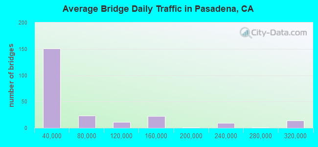
- 13,865,314Total average daily traffic
- 685,839Total average daily truck traffic
- National Bridge Inventory (NBI) Registered Bridges for Pasadena
- No street view available for this location
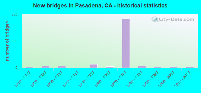
- New bridges - historical statistics
- 31910-1919
- 61920-1929
- 61930-1939
- 131950-1959
- 51960-1969
- 1841970-1979
- 61980-1989
- 41990-1999
- 32000-2009
- 22010-2019
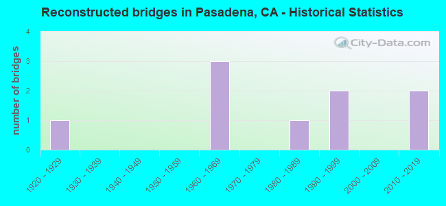
- Reconstructed bridges - Historical Statistics
- 11920-1929
- 01930-1939
- 01940-1949
- 01950-1959
- 31960-1969
- 01970-1979
- 11980-1989
- 21990-1999
- 02000-2009
- 22010-2019
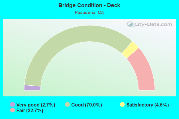
- Bridge Condition - Deck
- 2.7%Very good
- 70.0%Good
- 4.5%Satisfactory
- 22.7%Fair
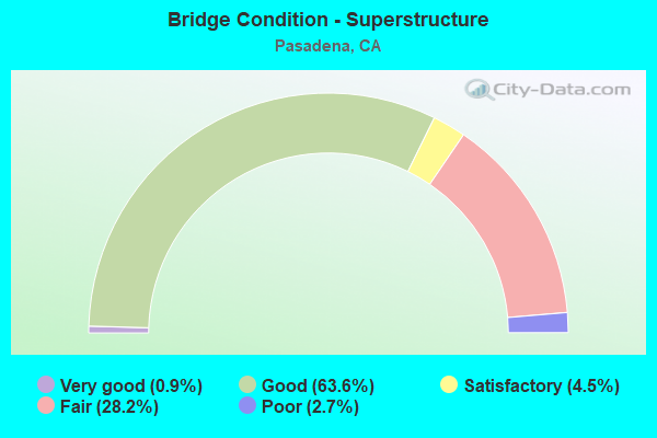
- Bridge Condition - Superstructure
- 0.9%Very good
- 63.6%Good
- 4.5%Satisfactory
- 28.2%Fair
- 2.7%Poor
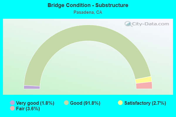
- Bridge Condition - Substructure
- 1.8%Very good
- 91.8%Good
- 2.7%Satisfactory
- 3.6%Fair
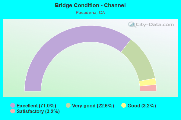
- Bridge Condition - Channel
- 71.0%Excellent
- 22.6%Very good
- 3.2%Good
- 3.2%Satisfactory
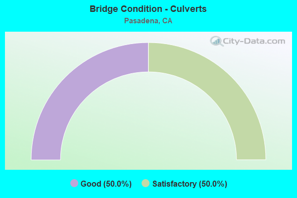
- Bridge Condition - Culverts
- 50.0%Good
- 50.0%Satisfactory
Find on map >> Show street view
Structure Number: 53 2093R, Location: 07-LA-210-R27.18-PAS (Lat: 34.152028, Lng: -118.117594), Route carried "under" structure: City street Q310, Year Built: 1976, Structure Length: 0. m, Average Daily Traffic: 2,500 (year 2015), Truck Traffic: 2%, Features Intersected: SIERRA BONITA AVE, Facility Carried by Structure: INTERSTATE 210 EB
Minimum Vertical Clearance: 6.45m (21.16ft), Kilometerpoint: 0.000, Lanes on structure: 7, Lanes under structure: 5, Material/Design: Prestressed concrete, Design/Construction: Box Beam or Girders - Multiple, Length of Maximum Span: 47.9m (157.2ft)
Find on map >> Show street view
Structure Number: 53 2097, Location: 07-LA-134-R12.36-PAS (Lat: 34.143489, Lng: -118.171089), Route carried "under" structure: State highway 134, Year Built: 1971, Structure Length: 0. m, Average Daily Traffic: 224,000 (year 2017), Truck Traffic: 3%, Features Intersected: STATE ROUTE 134, Facility Carried by Structure: SAN RAFAEL AVE
Minimum Vertical Clearance: 5.16m (16.93ft), Kilometerpoint: 12.360, Lanes on structure: 5, Lanes under structure: 10, Material/Design: Concrete continuous, Design/Construction: Box Beam or Girders - Multiple, Length of Maximum Span: 28.8m (94.5ft)
Find on map >> Show street view
Structure Number: 53 2099L, Location: 07-LA-210-R28.87-PAS (Lat: 34.150253, Lng: -118.088692), Route carried "under" structure: City street L718, Year Built: 1976, Structure Length: 0. m, Average Daily Traffic: 60,500 (year 2015), Truck Traffic: 7%, Features Intersected: FOOTHILL BLVD, Facility Carried by Structure: INTERSTATE 210 WB
Minimum Vertical Clearance: 6.45m (21.16ft), Kilometerpoint: 0.000, Lanes on structure: 7, Lanes under structure: 4, Material/Design: Prestressed concrete continuous, Design/Construction: Box Beam or Girders - Multiple, Length of Maximum Span: 38.7m (127.0ft)
Find on map >> Show street view
Structure Number: 53 2099R, Location: 07-LA-210-R28.87-PAS (Lat: 34.150239, Lng: -118.089342), Route carried "under" structure: City street L718, Year Built: 1976, Structure Length: 0. m, Average Daily Traffic: 60,500 (year 2015), Truck Traffic: 3%, Features Intersected: FOOTHILL BLVD, Facility Carried by Structure: INTERSTATE 210 EB
Minimum Vertical Clearance: 7.62m (25.00ft), Kilometerpoint: 0.000, Lanes on structure: 7, Lanes under structure: 4, Material/Design: Prestressed concrete continuous, Design/Construction: Box Beam or Girders - Multiple, Length of Maximum Span: 38.7m (127.0ft)
Find on map >> Show street view
Structure Number: 53 2153, Location: 07-LA-210-R22.49-PAS (Lat: 34.181639, Lng: -118.169122), Route carried "under" structure: Interstate 210, Year Built: 1973, Structure Length: 0. m, Average Daily Traffic: 113,000 (year 2015), Truck Traffic: 10%, Features Intersected: ROUTE 210, Facility Carried by Structure: ARROYO BLVD
Minimum Vertical Clearance: 5.36m (17.59ft), Kilometerpoint: 22.490, Lanes on structure: 6, Lanes under structure: 8, Material/Design: Prestressed concrete continuous, Design/Construction: Box Beam or Girders - Multiple, Length of Maximum Span: 38.1m (125.0ft)
Find on map >> Show street view
Structure Number: 53 2154, Location: 07-LA-210-R22.84-PAS (Lat: 34.177733, Lng: -118.164608), Route carried "under" structure: City street , Year Built: 1973, Structure Length: 0. m, Average Daily Traffic: 1,200 (year 2015), Truck Traffic: 2%, Features Intersected: CASITAS AVE, Facility Carried by Structure: INTERSTATE 210
Minimum Vertical Clearance: 4.34m (14.24ft), Kilometerpoint: 0.000, Lanes on structure: 10, Lanes under structure: 2, Material/Design: Prestressed concrete, Design/Construction: Box Beam or Girders - Multiple, Length of Maximum Span: 42.7m (140.1ft)
Find on map >> Show street view
Structure Number: 53 2155, Location: 07-LA-210-R23.19-PAS (Lat: 34.174039, Lng: -118.159928), Route carried "under" structure: City street , Year Built: 1973, Structure Length: 0. m, Average Daily Traffic: 7,500 (year 2015), Truck Traffic: 2%, Features Intersected: LINCOLN - HOWARD UC, Facility Carried by Structure: INTERSTATE 210
Minimum Vertical Clearance: 5.05m (16.57ft), Kilometerpoint: 23.190, Lanes on structure: 9, Lanes under structure: 7, Material/Design: Prestressed concrete continuous, Design/Construction: Box Beam or Girders - Multiple, Length of Maximum Span: 44.5m (146.0ft)
Find on map >> Show street view
Structure Number: 53 2155, Location: 07-LA-210-R23.19-PAS (Lat: 34.174039, Lng: -118.159928), Route carried "under" structure: City street , Year Built: 1973, Structure Length: 0. m, Average Daily Traffic: 12,000 (year 2015), Truck Traffic: 3%, Features Intersected: LINCOLN - HOWARD UC, Facility Carried by Structure: INTERSTATE 210
Minimum Vertical Clearance: 4.78m (15.68ft), Kilometerpoint: 23.190, Lanes on structure: 9, Lanes under structure: 7, Material/Design: Prestressed concrete continuous, Design/Construction: Box Beam or Girders - Multiple, Length of Maximum Span: 44.5m (146.0ft)
Find on map >> Show street view
Structure Number: 53 2156K, Location: 07-LA-210-R23.22-PAS (Lat: 34.173606, Lng: -118.158642), Route carried "under" structure: City street , Year Built: 1973, Structure Length: 0. m, Average Daily Traffic: 7,500 (year 2015), Truck Traffic: 2%, Features Intersected: HOWARD STREET, Facility Carried by Structure: INTERSTATE 210 OFF
Minimum Vertical Clearance: 5.82m (19.09ft), Kilometerpoint: 23.220, Lanes on structure: 1, Lanes under structure: 2, Material/Design: Prestressed concrete, Design/Construction: Box Beam or Girders - Multiple, Length of Maximum Span: 46.3m (151.9ft)
Find on map >> Show street view
Structure Number: 53 2157, Location: 07-LA-210-R23.55-PAS (Lat: 34.169772, Lng: -118.158119), Route carried "under" structure: City street Q295, Year Built: 1973, Structure Length: 0. m, Average Daily Traffic: 10,500 (year 2015), Truck Traffic: 2%, Features Intersected: WASHINGTON BLVD, Facility Carried by Structure: INTERSTATE 210
Minimum Vertical Clearance: 5.11m (16.77ft), Kilometerpoint: 0.000, Lanes on structure: 10, Lanes under structure: 4, Material/Design: Prestressed concrete, Design/Construction: Box Beam or Girders - Multiple, Length of Maximum Span: 41.8m (137.1ft)
Find on map >> Show street view
Structure Number: 53 2158, Location: 07-LA-210-R23.80-PAS (Lat: 34.166167, Lng: -118.158400), Route carried "under" structure: City street Q489, Year Built: 1973, Structure Length: 0. m, Average Daily Traffic: 1,800 (year 2015), Truck Traffic: 2%, Features Intersected: HAMMOND STREET, Facility Carried by Structure: INTERSTATE 210
Minimum Vertical Clearance: 4.47m (14.67ft), Kilometerpoint: 0.000, Lanes on structure: 11, Lanes under structure: 2, Material/Design: Prestressed concrete, Design/Construction: Box Beam or Girders - Multiple, Length of Maximum Span: 39.3m (128.9ft)
Find on map >> Show street view
Structure Number: 53 2159, Location: 07-LA-210-R24.06-PAS (Lat: 34.162389, Lng: -118.158728), Route carried "under" structure: City street Q488, Year Built: 1973, Structure Length: 0. m, Average Daily Traffic: 9,500 (year 2015), Truck Traffic: 2%, Features Intersected: MOUNTAIN AVENUE, Facility Carried by Structure: INTERSTATE 210
Minimum Vertical Clearance: 4.47m (14.67ft), Kilometerpoint: 0.000, Lanes on structure: 10, Lanes under structure: 6, Material/Design: Prestressed concrete, Design/Construction: Box Beam or Girders - Multiple, Length of Maximum Span: 45.7m (149.9ft)
Find on map >> Show street view
Structure Number: 53 216, Location: 07-LA-210-R24.17-PAS (Lat: 34.161058, Lng: -118.158842), Route carried "under" structure: City street L509, Year Built: 1973, Structure Length: 0. m, Average Daily Traffic: 7,560 (year 2015), Truck Traffic: 2%, Features Intersected: LINCOLN AVE, Facility Carried by Structure: INTERSTATE 210
Minimum Vertical Clearance: 5.00m (16.40ft), Kilometerpoint: 0.000, Lanes on structure: 12, Lanes under structure: 2, Material/Design: Prestressed concrete continuous, Design/Construction: Box Beam or Girders - Multiple, Length of Maximum Span: 43.3m (142.1ft)
Find on map >> Show street view
Structure Number: 53 2160S, Location: 07-LA-210-R24.17-PAS (Lat: 34.161244, Lng: -118.159044), Route carried "under" structure: City street L509, Year Built: 1973, Structure Length: 0. m, Average Daily Traffic: 7,560 (year 2015), Truck Traffic: 2%, Features Intersected: LINCOLN AVE, Facility Carried by Structure: INTERSTATE 210 ONR
Minimum Vertical Clearance: 6.15m (20.18ft), Kilometerpoint: 0.000, Lanes on structure: 2, Lanes under structure: 2, Material/Design: Prestressed concrete continuous, Design/Construction: Box Beam or Girders - Multiple, Length of Maximum Span: 47.9m (157.2ft)
Find on map >> Show street view
Structure Number: 53 2173, Location: 07-LA-210-R22.14-PAS (Lat: 34.183408, Lng: -118.174328), Route carried "under" structure: Interstate 210, Year Built: 1974, Structure Length: 0. m, Average Daily Traffic: 113,000 (year 2010), Truck Traffic: 10%, Features Intersected: ARROYO SECO
Minimum Vertical Clearance: 13.30m (43.64ft), Kilometerpoint: 22.140, Lanes on structure: 8, Lanes under structure: 8, Material/Design: Prestressed concrete continuous, Design/Construction: Box Beam or Girders - Multiple, Length of Maximum Span: 70.1m (230.0ft)
Find on map >> Show street view
Structure Number: 53 2195, Location: 07-LA-210-R24.64-PAS (Lat: 34.154567, Lng: -118.156644), Route carried "under" structure: State highway 210, Year Built: 1973, Structure Length: 0. m, Average Daily Traffic: 8,350 (year 2015), Truck Traffic: 7%, Features Intersected: I 210 & CONNECTORS, Facility Carried by Structure: ORANGE GROVE BLVD
Minimum Vertical Clearance: 5.26m (17.26ft), Kilometerpoint: 24.640, Lanes on structure: 4, Lanes under structure: 15, Material/Design: Prestressed concrete continuous, Design/Construction: Box Beam or Girders - Multiple, Length of Maximum Span: 59.4m (194.9ft)
Find on map >> Show street view
Structure Number: 53 2197K, Location: 07-LA-134-R12.90-PAS (Lat: 34.146231, Lng: -118.164347), Route carried "under" structure: State highway 134, Year Built: 1971, Structure Length: 0. m, Average Daily Traffic: 224,000 (year 2014), Truck Traffic: 6%, Features Intersected: ST RTE 134 & STREETS
Minimum Vertical Clearance: 5.94m (19.49ft), Kilometerpoint: 12.900, Lanes on structure: 2, Lanes under structure: 13, Material/Design: Prestressed concrete continuous, Design/Construction: Box Beam or Girders - Multiple, Length of Maximum Span: 53.6m (175.9ft)
Find on map >> Show street view
Structure Number: 53 2197K, Location: 07-LA-134-R12.90-PAS (Lat: 34.146231, Lng: -118.164347), Route carried "under" structure: City street , Year Built: 1971, Structure Length: 0. m, Average Daily Traffic: 4,500 (year 1998), Truck Traffic: 1%, Features Intersected: ST RTE 134 & STREETS, Facility Carried by Structure: ORANGE GROVE-W134
Minimum Vertical Clearance: 17.22m (56.50ft), Kilometerpoint: 0.000, Lanes on structure: 2, Lanes under structure: 2, Material/Design: Prestressed concrete continuous, Design/Construction: Box Beam or Girders - Multiple, Length of Maximum Span: 53.6m (175.9ft)
Find on map >> Show street view
Structure Number: 53 2197K, Location: 07-LA-134-R12.90-PAS (Lat: 34.146231, Lng: -118.164347), Route carried "under" structure: City street , Year Built: 1971, Structure Length: 0. m, Average Daily Traffic: 4,500 (year 1998), Truck Traffic: 1%, Features Intersected: ST RTE 134 & STREETS, Facility Carried by Structure: ORANGE GROVE-W134
Minimum Vertical Clearance: 4.83m (15.85ft), Kilometerpoint: 0.000, Lanes on structure: 2, Lanes under structure: 2, Material/Design: Prestressed concrete continuous, Design/Construction: Box Beam or Girders - Multiple, Length of Maximum Span: 53.6m (175.9ft)
Find on map >> Show street view
Structure Number: 53 2226, Location: 07-LA-134-R12.90-PAS (Lat: 34.145658, Lng: -118.162575), Route carried "under" structure: Ramp State highway 134, Year Built: 1971, Structure Length: 0. m, Average Daily Traffic: 6,401 (year 2014), Truck Traffic: 6%, Features Intersected: E134-COLORADO BL OFF-RMP, Facility Carried by Structure: COLORADO BLVD WB
Minimum Vertical Clearance: 5.00m (16.40ft), Kilometerpoint: 12.900, Lanes on structure: 1, Lanes under structure: 2, Material/Design: Concrete continuous, Design/Construction: Box Beam or Girders - Multiple, Length of Maximum Span: 25.3m (83.0ft)
Find on map >> Show street view
Structure Number: 53 2253K, Location: 07-LA-134-R13.08-PAS (Lat: 34.147750, Lng: -118.160264), Route carried "under" structure: Ramp Interstate 210, Year Built: 1974, Structure Length: 0. m, Average Daily Traffic: 6,300 (year 2013), Truck Traffic: 2%, Features Intersected: E210-W134 & N710-W134, Facility Carried by Structure: W134-ORANGE GROVE
Minimum Vertical Clearance: 5.64m (18.50ft), Kilometerpoint: 13.000, Lanes on structure: 2, Lanes under structure: 1, Material/Design: Prestressed concrete continuous, Design/Construction: Box Beam or Girders - Multiple, Length of Maximum Span: 53.3m (174.9ft)
Find on map >> Show street view
Structure Number: 53 2253K, Location: 07-LA-134-R13.08-PAS (Lat: 34.147750, Lng: -118.160264), Route carried "under" structure: Ramp State highway 710, Year Built: 1974, Structure Length: 0. m, Average Daily Traffic: 7,690 (year 2015), Truck Traffic: 5%, Features Intersected: E210-W134 & N710-W134, Facility Carried by Structure: W134-ORANGE GROVE
Minimum Vertical Clearance: 5.33m (17.49ft), Kilometerpoint: 32.570, Lanes on structure: 2, Lanes under structure: 1, Material/Design: Prestressed concrete continuous, Design/Construction: Box Beam or Girders - Multiple, Length of Maximum Span: 53.3m (174.9ft)
Find on map >> Show street view
Structure Number: 53 2254, Location: 07-LA-210-R24.58-PAS (Lat: 34.152075, Lng: -118.153547), Route carried "under" structure: State highway 210, Year Built: 1975, Structure Length: 0. m, Average Daily Traffic: 8,350 (year 2015), Truck Traffic: 7%, Features Intersected: I-210 & I-710 CONN, Facility Carried by Structure: MAPLE ST
Minimum Vertical Clearance: 5.33m (17.49ft), Kilometerpoint: 24.860, Lanes on structure: 2, Lanes under structure: 7, Material/Design: Prestressed concrete continuous, Design/Construction: Box Beam or Girders - Multiple, Length of Maximum Span: 49.1m (161.1ft)
Find on map >> Show street view
Structure Number: 53 2254, Location: 07-LA-210-R24.58-PAS (Lat: 34.152075, Lng: -118.153547), Route carried "under" structure: State highway 210, Year Built: 1975, Structure Length: 0. m, Average Daily Traffic: 8,350 (year 2015), Truck Traffic: 7%, Features Intersected: I-210 & I-710 CONN, Facility Carried by Structure: MAPLE ST
Minimum Vertical Clearance: 5.40m (17.72ft), Kilometerpoint: 24.580, Lanes on structure: 2, Lanes under structure: 1, Material/Design: Prestressed concrete continuous, Design/Construction: Box Beam or Girders - Multiple, Length of Maximum Span: 49.1m (161.1ft)
Find on map >> Show street view
Structure Number: 53 2254, Location: 07-LA-210-R24.58-PAS (Lat: 34.152075, Lng: -118.153547), Route carried "under" structure: State highway 210, Year Built: 1975, Structure Length: 0. m, Average Daily Traffic: 8,350 (year 2015), Truck Traffic: 7%, Features Intersected: I-210 & I-710 CONN, Facility Carried by Structure: MAPLE ST
Minimum Vertical Clearance: 5.56m (18.24ft), Kilometerpoint: 24.580, Lanes on structure: 2, Lanes under structure: 2, Material/Design: Prestressed concrete continuous, Design/Construction: Box Beam or Girders - Multiple, Length of Maximum Span: 49.1m (161.1ft)
Find on map >> Show street view
Structure Number: 53 2254, Location: 07-LA-210-R24.58-PAS (Lat: 34.152075, Lng: -118.153547), Route carried "under" structure: State highway 210, Year Built: 1975, Structure Length: 0. m, Average Daily Traffic: 8,350 (year 2015), Truck Traffic: 7%, Features Intersected: I-210 & I-710 CONN, Facility Carried by Structure: MAPLE ST
Minimum Vertical Clearance: 5.26m (17.26ft), Kilometerpoint: 24.860, Lanes on structure: 2, Lanes under structure: 2, Material/Design: Prestressed concrete continuous, Design/Construction: Box Beam or Girders - Multiple, Length of Maximum Span: 49.1m (161.1ft)
Find on map >> Show street view
Structure Number: 53 2255F, Location: 07-LA-210-R25.10-PAS (Lat: 34.151392, Lng: -118.154206), Route carried "under" structure: Interstate 210, Year Built: 1974, Structure Length: 0. m, Average Daily Traffic: 294,000 (year 2015), Truck Traffic: 5%, Features Intersected: ROUTE 210 EB
Minimum Vertical Clearance: 5.56m (18.24ft), Kilometerpoint: 25.100, Lanes on structure: 3, Lanes under structure: 2, Material/Design: Prestressed concrete, Design/Construction: Box Beam or Girders - Multiple, Length of Maximum Span: 46.3m (151.9ft)
Find on map >> Show street view
Structure Number: 53 2257, Location: 07-LA-710-R32.68-PAS (Lat: 34.148811, Lng: -118.154386), Route carried "under" structure: Ramp State highway 710, Year Built: 1975, Structure Length: 0. m, Average Daily Traffic: 73,000 (year 2009), Truck Traffic: 2%, Features Intersected: N710-E210 CONNECTOR RAMP, Facility Carried by Structure: S. PASADENA AVE
Minimum Vertical Clearance: 5.64m (18.50ft), Kilometerpoint: 32.680, Lanes on structure: 2, Lanes under structure: 2, Material/Design: Prestressed concrete, Design/Construction: Box Beam or Girders - Multiple, Length of Maximum Span: 57.0m (187.0ft)
Find on map >> Show street view
Structure Number: 53 2258, Location: 07-LA-710-R32.69-PAS (Lat: 34.149544, Lng: -118.154444), Route carried "under" structure: Ramp State highway 710, Year Built: 1975, Structure Length: 0. m, Average Daily Traffic: 73,000 (year 2009), Truck Traffic: 2%, Features Intersected: N710-E210 CONNECTOR RAMP, Facility Carried by Structure: WALNUT ST
Minimum Vertical Clearance: 5.13m (16.83ft), Kilometerpoint: 32.690, Lanes on structure: 5, Lanes under structure: 3, Material/Design: Prestressed concrete, Design/Construction: Box Beam or Girders - Multiple, Length of Maximum Span: 45.7m (149.9ft)
Find on map >> Show street view
Structure Number: 53 2259K, Location: 07-LA-210-R25.21-PAS (Lat: 34.151506, Lng: -118.152444), Route carried "under" structure: Interstate 210, Year Built: 1974, Structure Length: 0. m, Average Daily Traffic: 295,000 (year 2015), Truck Traffic: 5%, Features Intersected: W210-S710 & W210 CONN
Minimum Vertical Clearance: 5.05m (16.57ft), Kilometerpoint: 25.470, Lanes on structure: 2, Lanes under structure: 2, Material/Design: Prestressed concrete continuous, Design/Construction: Box Beam or Girders - Multiple, Length of Maximum Span: 50.3m (165.0ft)
Find on map >> Show street view
Structure Number: 53 2259K, Location: 07-LA-210-R25.21-PAS (Lat: 34.151506, Lng: -118.152444), Route carried "under" structure: Ramp Interstate 210, Year Built: 1974, Structure Length: 0. m, Average Daily Traffic: 14,600 (year 2015), Truck Traffic: 5%, Features Intersected: W210-S710 & W210 CONN
Minimum Vertical Clearance: 5.05m (16.57ft), Kilometerpoint: 25.250, Lanes on structure: 2, Lanes under structure: 2, Material/Design: Prestressed concrete continuous, Design/Construction: Box Beam or Girders - Multiple, Length of Maximum Span: 50.3m (165.0ft)
Find on map >> Show street view
Structure Number: 53 226, Location: 07-LA-210-R24.94-PAS (Lat: 34.149672, Lng: -118.157694), Route carried "under" structure: Ramp Interstate 210, Year Built: 1974, Structure Length: 0. m, Average Daily Traffic: 5,700 (year 2015), Truck Traffic: 7%, Features Intersected: E210-W134 CONNECTOR RAMP, Facility Carried by Structure: WALNUT ST
Minimum Vertical Clearance: 5.18m (16.99ft), Kilometerpoint: 24.940, Lanes on structure: 3, Lanes under structure: 2, Material/Design: Prestressed concrete, Design/Construction: Box Beam or Girders - Multiple, Length of Maximum Span: 43.3m (142.1ft)
Find on map >> Show street view
Structure Number: 53 2262, Location: 07-LA-710-T32.11-PAS (Lat: 34.140622, Lng: -118.155575), Route carried "under" structure: State highway 710, Year Built: 1975, Structure Length: 0. m, Average Daily Traffic: 47,000 (year 2017), Truck Traffic: 2%, Features Intersected: INTERSTATE 710, Facility Carried by Structure: DEL MAR BLVD
Minimum Vertical Clearance: 5.20m (17.06ft), Kilometerpoint: 32.110, Lanes on structure: 4, Lanes under structure: 3, Material/Design: Prestressed concrete continuous, Design/Construction: Box Beam or Girders - Multiple, Length of Maximum Span: 54.9m (180.1ft)
Find on map >> Show street view
Structure Number: 53 2263, Location: 07-LA-710-R32.37-PAS (Lat: 34.144544, Lng: -118.155597), Route carried "under" structure: Ramp Interstate 710, Year Built: 1975, Structure Length: 0. m, Average Daily Traffic: 73,000 (year 2009), Truck Traffic: 2%, Features Intersected: INTERSTATE 710, Facility Carried by Structure: GREEN ST
Minimum Vertical Clearance: 6.55m (21.49ft), Kilometerpoint: 32.370, Lanes on structure: 3, Lanes under structure: 1, Material/Design: Prestressed concrete continuous, Design/Construction: Box Beam or Girders - Multiple, Length of Maximum Span: 53.3m (174.9ft)
Find on map >> Show street view
Structure Number: 53 2263, Location: 07-LA-710-R32.37-PAS (Lat: 34.144544, Lng: -118.155597), Route carried "under" structure: Ramp Interstate 134, Year Built: 1975, Structure Length: 0. m, Average Daily Traffic: 52,500 (year 2009), Truck Traffic: 2%, Features Intersected: INTERSTATE 710, Facility Carried by Structure: GREEN ST
Minimum Vertical Clearance: 6.99m (22.93ft), Kilometerpoint: 13.230, Lanes on structure: 3, Lanes under structure: 1, Material/Design: Prestressed concrete continuous, Design/Construction: Box Beam or Girders - Multiple, Length of Maximum Span: 53.3m (174.9ft)
Find on map >> Show street view
Structure Number: 53 2263, Location: 07-LA-710-R32.37-PAS (Lat: 34.144544, Lng: -118.155597), Route carried "under" structure: State highway 710, Year Built: 1975, Structure Length: 0. m, Average Daily Traffic: 47,000 (year 2017), Truck Traffic: 2%, Features Intersected: INTERSTATE 710, Facility Carried by Structure: GREEN ST
Minimum Vertical Clearance: 6.43m (21.10ft), Kilometerpoint: 32.370, Lanes on structure: 3, Lanes under structure: 5, Material/Design: Prestressed concrete continuous, Design/Construction: Box Beam or Girders - Multiple, Length of Maximum Span: 53.3m (174.9ft)
Find on map >> Show street view
Structure Number: 53 2264, Location: 07-LA-710-R32.45-PAS (Lat: 34.145614, Lng: -118.155747), Route carried "under" structure: Ramp Interstate 710, Year Built: 1975, Structure Length: 0. m, Average Daily Traffic: 73,000 (year 2009), Truck Traffic: 2%, Features Intersected: INTERSTATE 710, Facility Carried by Structure: COLORADO BLVD
Minimum Vertical Clearance: 5.56m (18.24ft), Kilometerpoint: 32.450, Lanes on structure: 5, Lanes under structure: 1, Material/Design: Prestressed concrete continuous, Design/Construction: Box Beam or Girders - Multiple, Length of Maximum Span: 63.1m (207.0ft)
Find on map >> Show street view
Structure Number: 53 2264, Location: 07-LA-710-R32.45-PAS (Lat: 34.145614, Lng: -118.155747), Route carried "under" structure: State highway 710, Year Built: 1975, Structure Length: 0. m, Average Daily Traffic: 66,000 (year 2017), Truck Traffic: 2%, Features Intersected: INTERSTATE 710, Facility Carried by Structure: COLORADO BLVD
Minimum Vertical Clearance: 6.38m (20.93ft), Kilometerpoint: 32.450, Lanes on structure: 5, Lanes under structure: 6, Material/Design: Prestressed concrete continuous, Design/Construction: Box Beam or Girders - Multiple, Length of Maximum Span: 63.1m (207.0ft)
Find on map >> Show street view
Structure Number: 53 2264, Location: 07-LA-710-R32.45-PAS (Lat: 34.145614, Lng: -118.155747), Route carried "under" structure: Ramp Interstate 134, Year Built: 1975, Structure Length: 0. m, Average Daily Traffic: 52,500 (year 2009), Truck Traffic: 2%, Features Intersected: INTERSTATE 710, Facility Carried by Structure: COLORADO BLVD
Minimum Vertical Clearance: 7.08m (23.23ft), Kilometerpoint: 13.230, Lanes on structure: 5, Lanes under structure: 1, Material/Design: Prestressed concrete continuous, Design/Construction: Box Beam or Girders - Multiple, Length of Maximum Span: 63.1m (207.0ft)
Find on map >> Show street view
Structure Number: 53 2265, Location: 07-LA-134-R13.23-PAS (Lat: 34.146789, Lng: -118.155928), Route carried "under" structure: Ramp State highway 134, Year Built: 1975, Structure Length: 0. m, Average Daily Traffic: 225,000 (year 2017), Truck Traffic: 6%, Features Intersected: E134-S710 CONNECTOR RAMP, Facility Carried by Structure: ST JOHN AVENUE
Minimum Vertical Clearance: 5.69m (18.67ft), Kilometerpoint: 13.230, Lanes on structure: 2, Lanes under structure: 1, Material/Design: Prestressed concrete, Design/Construction: Box Beam or Girders - Multiple, Length of Maximum Span: 31.6m (103.7ft)
Find on map >> Show street view
Structure Number: 53 2266G, Location: 07-LA-710-R32.63-PAS (Lat: 34.147289, Lng: -118.154558), Route carried "under" structure: City street , Year Built: 1975, Structure Length: 0. m, Average Daily Traffic: 2,200 (year 2009), Truck Traffic: 1%, Features Intersected: I 710, CONNS, ST JOHN AV, Facility Carried by Structure: N710-W134 CONNECTR
Minimum Vertical Clearance: 4.95m (16.24ft), Kilometerpoint: 0.000, Lanes on structure: 2, Lanes under structure: 2, Material/Design: Prestressed concrete continuous, Design/Construction: Box Beam or Girders - Multiple, Length of Maximum Span: 54.9m (180.1ft)
Find on map >> Show street view
Structure Number: 53 2266G, Location: 07-LA-710-R32.63-PAS (Lat: 34.147289, Lng: -118.154558), Route carried "under" structure: Ramp Interstate 210, Year Built: 1975, Structure Length: 0. m, Average Daily Traffic: 52,000 (year 2009), Truck Traffic: 2%, Features Intersected: I 710, CONNS, ST JOHN AV, Facility Carried by Structure: N710-W134 CONNECTR
Minimum Vertical Clearance: 7.62m (25.00ft), Kilometerpoint: 32.630, Lanes on structure: 2, Lanes under structure: 2, Material/Design: Prestressed concrete continuous, Design/Construction: Box Beam or Girders - Multiple, Length of Maximum Span: 54.9m (180.1ft)
Find on map >> Show street view
Structure Number: 53 2266G, Location: 07-LA-710-R32.63-PAS (Lat: 34.147289, Lng: -118.154558), Route carried "under" structure: Ramp State highway 710, Year Built: 1975, Structure Length: 0. m, Average Daily Traffic: 73,000 (year 2009), Truck Traffic: 2%, Features Intersected: I 710, CONNS, ST JOHN AV
Minimum Vertical Clearance: 5.56m (18.24ft), Kilometerpoint: 32.630, Lanes on structure: 2, Lanes under structure: 2, Material/Design: Prestressed concrete continuous, Design/Construction: Box Beam or Girders - Multiple, Length of Maximum Span: 54.9m (180.1ft)
Find on map >> Show street view
Structure Number: 53 2266G, Location: 07-LA-710-R32.63-PAS (Lat: 34.147289, Lng: -118.154558), Route carried "under" structure: State highway 710, Year Built: 1975, Structure Length: 0. m, Average Daily Traffic: 66,000 (year 2017), Truck Traffic: 2%, Features Intersected: I 710, CONNS, ST JOHN AV
Minimum Vertical Clearance: 7.62m (25.00ft), Kilometerpoint: 32.630, Lanes on structure: 2, Lanes under structure: 4, Material/Design: Prestressed concrete continuous, Design/Construction: Box Beam or Girders - Multiple, Length of Maximum Span: 54.9m (180.1ft)
Find on map >> Show street view
Structure Number: 53 2267, Location: 07-LA-210-R24.95-PAS (Lat: 34.149611, Lng: -118.155003), Route carried "under" structure: Ramp Interstate 210, Year Built: 1975, Structure Length: 0. m, Average Daily Traffic: 15,200 (year 2015), Truck Traffic: 8%, Features Intersected: W210&E210-S710,N710-W210, Facility Carried by Structure: WALNUT STREET
Minimum Vertical Clearance: 5.84m (19.16ft), Kilometerpoint: 24.950, Lanes on structure: 5, Lanes under structure: 1, Material/Design: Prestressed concrete continuous, Design/Construction: Box Beam or Girders - Multiple, Length of Maximum Span: 41.8m (137.1ft)
Find on map >> Show street view
Structure Number: 53 2267, Location: 07-LA-210-R24.95-PAS (Lat: 34.149611, Lng: -118.155003), Route carried "under" structure: Ramp State highway 710, Year Built: 1975, Structure Length: 0. m, Average Daily Traffic: 9,300 (year 2015), Truck Traffic: 1%, Features Intersected: W210&E210-S710,N710-W210, Facility Carried by Structure: WALNUT STREET
Minimum Vertical Clearance: 5.97m (19.59ft), Kilometerpoint: 32.720, Lanes on structure: 5, Lanes under structure: 4, Material/Design: Prestressed concrete continuous, Design/Construction: Box Beam or Girders - Multiple, Length of Maximum Span: 41.8m (137.1ft)
Find on map >> Show street view
Structure Number: 53 2269S, Location: 07-LA-134-R13.07-PAS (Lat: 34.147514, Lng: -118.160653), Route carried "under" structure: Ramp State highway 710, Year Built: 1974, Structure Length: 0. m, Average Daily Traffic: 8,950 (year 2015), Truck Traffic: 2%, Features Intersected: SR 134 & CONNECTORS, Facility Carried by Structure: ORANGE GROVE-E134
Minimum Vertical Clearance: 7.62m (25.00ft), Kilometerpoint: 32.580, Lanes on structure: 1, Lanes under structure: 1, Material/Design: Prestressed concrete continuous, Design/Construction: Box Beam or Girders - Multiple, Length of Maximum Span: 47.3m (155.2ft)
Find on map >> Show street view
Structure Number: 53 2269S, Location: 07-LA-134-R13.07-PAS (Lat: 34.147514, Lng: -118.160653), Route carried "under" structure: Interstate 210, Year Built: 1974, Structure Length: 0. m, Average Daily Traffic: 6,300 (year 2013), Truck Traffic: 5%, Features Intersected: SR 134 & CONNECTORS, Facility Carried by Structure: ORANGE GROVE-E134
Minimum Vertical Clearance: 7.62m (25.00ft), Kilometerpoint: 24.950, Lanes on structure: 1, Lanes under structure: 2, Material/Design: Prestressed concrete continuous, Design/Construction: Box Beam or Girders - Multiple, Length of Maximum Span: 47.3m (155.2ft)
Find on map >> Show street view
Structure Number: 53 2269S, Location: 07-LA-134-R13.07-PAS (Lat: 34.147514, Lng: -118.160653), Route carried "under" structure: State highway 134, Year Built: 1974, Structure Length: 0. m, Average Daily Traffic: 220,000 (year 2017), Truck Traffic: 6%, Features Intersected: SR 134 & CONNECTORS
Minimum Vertical Clearance: 5.69m (18.67ft), Kilometerpoint: 13.070, Lanes on structure: 1, Lanes under structure: 10, Material/Design: Prestressed concrete continuous, Design/Construction: Box Beam or Girders - Multiple, Length of Maximum Span: 47.3m (155.2ft)
Find on map >> Show street view
Structure Number: 53 2272, Location: 07-LA-210-R25.29-PAS (Lat: 34.152308, Lng: -118.150669), Route carried "under" structure: Interstate 210, Year Built: 1975, Structure Length: 0. m, Average Daily Traffic: 294,000 (year 2015), Truck Traffic: 5%, Features Intersected: ROUTE 210, Facility Carried by Structure: FAIR OAKS AVE
Minimum Vertical Clearance: 5.00m (16.40ft), Kilometerpoint: 25.290, Lanes on structure: 6, Lanes under structure: 16, Material/Design: Prestressed concrete continuous, Design/Construction: Box Beam or Girders - Multiple, Length of Maximum Span: 43.0m (141.1ft)
Find on map >> Show street view
Structure Number: 53 2273, Location: 07-LA-210-R25.54-PAS (Lat: 34.152383, Lng: -118.146183), Route carried "under" structure: Interstate 210, Year Built: 1976, Structure Length: 0. m, Average Daily Traffic: 294,000 (year 2015), Truck Traffic: 5%, Features Intersected: ROUTE 210, Facility Carried by Structure: MARENGO AVE
Minimum Vertical Clearance: 4.98m (16.34ft), Kilometerpoint: 25.540, Lanes on structure: 6, Lanes under structure: 14, Material/Design: Prestressed concrete continuous, Design/Construction: Box Beam or Girders - Multiple, Length of Maximum Span: 53.3m (174.9ft)
Find on map >> Show street view
Structure Number: 53 2274, Location: 07-LA-210-R25.81-PAS (Lat: 34.152311, Lng: -118.141658), Route carried "under" structure: Interstate 210, Year Built: 1976, Structure Length: 0. m, Average Daily Traffic: 294,000 (year 2015), Truck Traffic: 5%, Features Intersected: ROUTE 210, Facility Carried by Structure: LOS ROBLES AVE
Minimum Vertical Clearance: 5.28m (17.32ft), Kilometerpoint: 25.810, Lanes on structure: 6, Lanes under structure: 14, Material/Design: Prestressed concrete continuous, Design/Construction: Box Beam or Girders - Multiple, Length of Maximum Span: 53.0m (173.9ft)
Find on map >> Show street view
Structure Number: 53 2275, Location: 07-LA-210-R26.07-PAS (Lat: 34.152250, Lng: -118.137094), Route carried "under" structure: Interstate 210, Year Built: 1976, Structure Length: 0. m, Average Daily Traffic: 294,000 (year 2015), Truck Traffic: 5%, Features Intersected: ROUTE 210, Facility Carried by Structure: EL MOLINO AVE
Minimum Vertical Clearance: 5.11m (16.77ft), Kilometerpoint: 26.070, Lanes on structure: 5, Lanes under structure: 14, Material/Design: Prestressed concrete continuous, Design/Construction: Box Beam or Girders - Multiple, Length of Maximum Span: 62.2m (204.1ft)
Find on map >> Show street view
Structure Number: 53 2276, Location: 07-LA-210-R26.33-PAS (Lat: 34.152158, Lng: -118.132600), Route carried "under" structure: Interstate 210, Year Built: 1976, Structure Length: 0. m, Average Daily Traffic: 294,000 (year 2015), Truck Traffic: 5%, Features Intersected: ROUTE 210, Facility Carried by Structure: LAKE AVE
Minimum Vertical Clearance: 5.00m (16.40ft), Kilometerpoint: 26.330, Lanes on structure: 6, Lanes under structure: 10, Material/Design: Prestressed concrete continuous, Design/Construction: Box Beam or Girders - Multiple, Length of Maximum Span: 46.3m (151.9ft)
Find on map >> Show street view
Structure Number: 53 2277, Location: 07-LA-210-R26.57-PAS (Lat: 34.152322, Lng: -118.128281), Route carried "under" structure: Interstate 210, Year Built: 1976, Structure Length: 0. m, Average Daily Traffic: 294,000 (year 2015), Truck Traffic: 5%, Features Intersected: ROUTE 210, Facility Carried by Structure: WILSON AVE
Minimum Vertical Clearance: 5.13m (16.83ft), Kilometerpoint: 26.570, Lanes on structure: 6, Lanes under structure: 13, Material/Design: Prestressed concrete continuous, Design/Construction: Box Beam or Girders - Multiple, Length of Maximum Span: 48.5m (159.1ft)
Find on map >> Show street view
Structure Number: 53 2278L, Location: 07-LA-210-R28.25-PAS (Lat: 34.152614, Lng: -118.098861), Route carried "under" structure: City street L519, Year Built: 1976, Structure Length: 0. m, Average Daily Traffic: 60,500 (year 2015), Truck Traffic: 7%, Features Intersected: ALTADENA DR, Facility Carried by Structure: INTERSTATE 210 WB
Minimum Vertical Clearance: 5.05m (16.57ft), Kilometerpoint: 0.000, Lanes on structure: 7, Lanes under structure: 7, Material/Design: Concrete continuous, Design/Construction: Box Beam or Girders - Multiple, Length of Maximum Span: 29.0m (95.1ft)
Find on map >> Show street view
Structure Number: 53 2278R, Location: 07-LA-210-R28.25-PAS (Lat: 34.152222, Lng: -118.098858), Route carried "under" structure: City street L519, Year Built: 1976, Structure Length: 0. m, Average Daily Traffic: 22,720 (year 2012), Truck Traffic: 2%, Features Intersected: ALTADENA DR, Facility Carried by Structure: INTERSTATE 210 EB
Minimum Vertical Clearance: 5.94m (19.49ft), Kilometerpoint: 0.000, Lanes on structure: 7, Lanes under structure: 6, Material/Design: Concrete continuous, Design/Construction: Box Beam or Girders - Multiple, Length of Maximum Span: 29.0m (95.1ft)
Find on map >> Show street view
Structure Number: 53 2279L, Location: 07-LA-210-R28.46-PAS (Lat: 34.152625, Lng: -118.095050), Route carried "under" structure: City street L514, Year Built: 1976, Structure Length: 0. m, Average Daily Traffic: 60,500 (year 2012), Truck Traffic: 7%, Features Intersected: SIERRA MADRE BLVD, Facility Carried by Structure: INTERSTATE 210 WB
Minimum Vertical Clearance: 6.22m (20.41ft), Kilometerpoint: 0.000, Lanes on structure: 6, Lanes under structure: 11, Material/Design: Prestressed concrete continuous, Design/Construction: Box Beam or Girders - Multiple, Length of Maximum Span: 32.9m (107.9ft)
Find on map >> Show street view
Structure Number: 53 2279R, Location: 07-LA-210-R28.46-PAS (Lat: 34.152294, Lng: -118.095417), Route carried "under" structure: City street L514, Year Built: 1976, Structure Length: 0. m, Average Daily Traffic: 6,160 (year 2012), Truck Traffic: 2%, Features Intersected: SIERRA MADRE BLVD, Facility Carried by Structure: INTERSTATE 210 EB
Minimum Vertical Clearance: 5.71m (18.73ft), Kilometerpoint: 0.000, Lanes on structure: 6, Lanes under structure: 11, Material/Design: Prestressed concrete continuous, Design/Construction: Box Beam or Girders - Multiple, Length of Maximum Span: 34.7m (113.8ft)
Find on map >> Show street view
Structure Number: 53 2280L, Location: 07-LA-210-R28.73-PAS (Lat: 34.151583, Lng: -118.090744), Route carried "under" structure: City street Q295, Year Built: 1976, Structure Length: 0. m, Average Daily Traffic: 60,500 (year 2012), Truck Traffic: 7%, Features Intersected: SUNNYSLOPE AVE, Facility Carried by Structure: INTERSTATE 210 WB
Minimum Vertical Clearance: 7.39m (24.25ft), Kilometerpoint: 0.000, Lanes on structure: 7, Lanes under structure: 5, Material/Design: Prestressed concrete, Design/Construction: Box Beam or Girders - Multiple, Length of Maximum Span: 62.5m (205.1ft)
Find on map >> Show street view
Structure Number: 53 2280R, Location: 07-LA-210-R28.73-PAS (Lat: 34.151122, Lng: -118.090731), Route carried "under" structure: City street Q295, Year Built: 1976, Structure Length: 0. m, Average Daily Traffic: 27,200 (year 2012), Truck Traffic: 2%, Features Intersected: SUNNYSLOPE AVE, Facility Carried by Structure: INTERSTATE 210 EB
Minimum Vertical Clearance: 6.76m (22.18ft), Kilometerpoint: 0.000, Lanes on structure: 6, Lanes under structure: 4, Material/Design: Prestressed concrete, Design/Construction: Box Beam or Girders - Multiple, Length of Maximum Span: 61.9m (203.1ft)
Find on map >> Show street view
Structure Number: 53 2317, Location: 07-LA-134-R13.24-PAS (Lat: 34.148808, Lng: -118.156606), Route carried "under" structure: Ramp Interstate 210, Year Built: 1975, Structure Length: 0. m, Average Daily Traffic: 6,500 (year 2012), Truck Traffic: 3%, Features Intersected: I-710, STREET & CONN, Facility Carried by Structure: STATE ROUTE 134
Minimum Vertical Clearance: 5.82m (19.09ft), Kilometerpoint: 24.900, Lanes on structure: 12, Lanes under structure: 2, Material/Design: Prestressed concrete continuous, Design/Construction: Box Beam or Girders - Multiple, Length of Maximum Span: 67.1m (220.1ft)
Find on map >> Show street view
Structure Number: 53 2317, Location: 07-LA-134-R13.24-PAS (Lat: 34.148808, Lng: -118.156606), Route carried "under" structure: Ramp State highway 710, Year Built: 1975, Structure Length: 0. m, Average Daily Traffic: 10,720 (year 2015), Truck Traffic: 2%, Features Intersected: I-710, STREET & CONN, Facility Carried by Structure: STATE ROUTE 134
Minimum Vertical Clearance: 5.05m (16.57ft), Kilometerpoint: 32.560, Lanes on structure: 12, Lanes under structure: 2, Material/Design: Prestressed concrete continuous, Design/Construction: Box Beam or Girders - Multiple, Length of Maximum Span: 67.1m (220.1ft)
Find on map >> Show street view
Structure Number: 53 2317, Location: 07-LA-134-R13.24-PAS (Lat: 34.148808, Lng: -118.156606), Route carried "under" structure: City street , Year Built: 1975, Structure Length: 0. m, Average Daily Traffic: 6,480 (year 1998), Truck Traffic: 1%, Features Intersected: I-710, STREET & CONN, Facility Carried by Structure: STATE ROUTE 134
Minimum Vertical Clearance: 5.20m (17.06ft), Kilometerpoint: 0.000, Lanes on structure: 12, Lanes under structure: 5, Material/Design: Prestressed concrete continuous, Design/Construction: Box Beam or Girders - Multiple, Length of Maximum Span: 67.1m (220.1ft)
Find on map >> Show street view
Structure Number: 53 2317, Location: 07-LA-134-R13.24-PAS (Lat: 34.148808, Lng: -118.156606), Route carried "under" structure: City street , Year Built: 1975, Structure Length: 0. m, Average Daily Traffic: 3,000 (year 1991), Truck Traffic: 1%, Features Intersected: I-710, STREET & CONN, Facility Carried by Structure: STATE ROUTE 134
Minimum Vertical Clearance: 7.62m (25.00ft), Kilometerpoint: 0.000, Lanes on structure: 12, Lanes under structure: 2, Material/Design: Prestressed concrete continuous, Design/Construction: Box Beam or Girders - Multiple, Length of Maximum Span: 67.1m (220.1ft)
Find on map >> Show street view
Structure Number: 53 2317, Location: 07-LA-134-R13.24-PAS (Lat: 34.148808, Lng: -118.156606), Route carried "under" structure: Ramp Interstate 210, Year Built: 1975, Structure Length: 0. m, Average Daily Traffic: 10,500 (year 2013), Truck Traffic: 2%, Features Intersected: I-710, STREET & CONN, Facility Carried by Structure: STATE ROUTE 134
Minimum Vertical Clearance: 7.62m (25.00ft), Kilometerpoint: 24.950, Lanes on structure: 12, Lanes under structure: 2, Material/Design: Prestressed concrete continuous, Design/Construction: Box Beam or Girders - Multiple, Length of Maximum Span: 67.1m (220.1ft)
Find on map >> Show street view
Structure Number: 53 2317, Location: 07-LA-134-R13.24-PAS (Lat: 34.148808, Lng: -118.156606), Route carried "under" structure: State highway 710, Year Built: 1975, Structure Length: 0. m, Average Daily Traffic: 75,000 (year 2017), Truck Traffic: 2%, Features Intersected: I-710, STREET & CONN, Facility Carried by Structure: STATE ROUTE 134
Minimum Vertical Clearance: 5.05m (16.57ft), Kilometerpoint: 32.580, Lanes on structure: 12, Lanes under structure: 4, Material/Design: Prestressed concrete continuous, Design/Construction: Box Beam or Girders - Multiple, Length of Maximum Span: 67.1m (220.1ft)
Find on map >> Show street view
Structure Number: 53 2318G, Location: 07-LA-134-R13.25-PAS (Lat: 34.148253, Lng: -118.156567), Route carried "under" structure: Interstate 210, Year Built: 1974, Structure Length: 0. m, Average Daily Traffic: 6,300 (year 2013), Truck Traffic: 5%, Features Intersected: 210,710,134 & CONN
Minimum Vertical Clearance: 7.11m (23.33ft), Kilometerpoint: 24.980, Lanes on structure: 2, Lanes under structure: 2, Material/Design: Prestressed concrete continuous, Design/Construction: Box Beam or Girders - Multiple, Length of Maximum Span: 53.3m (174.9ft)
Find on map >> Show street view
Structure Number: 53 2318G, Location: 07-LA-134-R13.25-PAS (Lat: 34.148253, Lng: -118.156567), Route carried "under" structure: Ramp Interstate 210, Year Built: 1974, Structure Length: 0. m, Average Daily Traffic: 14,100 (year 2013), Truck Traffic: 5%, Features Intersected: 210,710,134 & CONN
Minimum Vertical Clearance: 7.62m (25.00ft), Kilometerpoint: 24.940, Lanes on structure: 2, Lanes under structure: 2, Material/Design: Prestressed concrete continuous, Design/Construction: Box Beam or Girders - Multiple, Length of Maximum Span: 53.3m (174.9ft)
Find on map >> Show street view
Structure Number: 53 2318G, Location: 07-LA-134-R13.25-PAS (Lat: 34.148253, Lng: -118.156567), Route carried "under" structure: State highway 710, Year Built: 1974, Structure Length: 0. m, Average Daily Traffic: 66,000 (year 2017), Truck Traffic: 2%, Features Intersected: 210,710,134 & CONN, Facility Carried by Structure: E134-W210 CONNECTR
Minimum Vertical Clearance: 7.62m (25.00ft), Kilometerpoint: 32.700, Lanes on structure: 2, Lanes under structure: 4, Material/Design: Prestressed concrete continuous, Design/Construction: Box Beam or Girders - Multiple, Length of Maximum Span: 53.3m (174.9ft)
Find on map >> Show street view
Structure Number: 53 2318G, Location: 07-LA-134-R13.25-PAS (Lat: 34.148253, Lng: -118.156567), Route carried "under" structure: State highway 134, Year Built: 1974, Structure Length: 0. m, Average Daily Traffic: 220,000 (year 2017), Truck Traffic: 6%, Features Intersected: 210,710,134 & CONN
Minimum Vertical Clearance: 5.46m (17.91ft), Kilometerpoint: 13.250, Lanes on structure: 2, Lanes under structure: 12, Material/Design: Prestressed concrete continuous, Design/Construction: Box Beam or Girders - Multiple, Length of Maximum Span: 53.3m (174.9ft)
Find on map >> Show street view
Structure Number: 53 2318G, Location: 07-LA-134-R13.25-PAS (Lat: 34.148253, Lng: -118.156567), Route carried "under" structure: Ramp Interstate 210, Year Built: 1974, Structure Length: 0. m, Average Daily Traffic: 6,500 (year 2012), Truck Traffic: 3%, Features Intersected: 210,710,134 & CONN
Minimum Vertical Clearance: 7.62m (25.00ft), Kilometerpoint: 24.970, Lanes on structure: 2, Lanes under structure: 2, Material/Design: Prestressed concrete continuous, Design/Construction: Box Beam or Girders - Multiple, Length of Maximum Span: 53.3m (174.9ft)
Find on map >> Show street view
Structure Number: 53 2318G, Location: 07-LA-134-R13.25-PAS (Lat: 34.148253, Lng: -118.156567), Route carried "under" structure: State highway 710, Year Built: 1974, Structure Length: 0. m, Average Daily Traffic: 8,950 (year 2015), Truck Traffic: 2%, Features Intersected: 210,710,134 & CONN, Facility Carried by Structure: E134-W210 CONNECTR
Minimum Vertical Clearance: 7.62m (25.00ft), Kilometerpoint: 32.550, Lanes on structure: 2, Lanes under structure: 2, Material/Design: Prestressed concrete continuous, Design/Construction: Box Beam or Girders - Multiple, Length of Maximum Span: 53.3m (174.9ft)
Find on map >> Show street view
Structure Number: 53 2318G, Location: 07-LA-134-R13.25-PAS (Lat: 34.148253, Lng: -118.156567), Route carried "under" structure: City street , Year Built: 1974, Structure Length: 0. m, Average Daily Traffic: 2,700 (year 1998), Truck Traffic: 2%, Features Intersected: 210,710,134 & CONN, Facility Carried by Structure: E134-W210 CONNECTR
Minimum Vertical Clearance: 7.62m (25.00ft), Kilometerpoint: 0.000, Lanes on structure: 2, Lanes under structure: 2, Material/Design: Prestressed concrete continuous, Design/Construction: Box Beam or Girders - Multiple, Length of Maximum Span: 53.3m (174.9ft)
Find on map >> Show street view
Structure Number: 53 2318G, Location: 07-LA-134-R13.25-PAS (Lat: 34.148253, Lng: -118.156567), Route carried "under" structure: City street , Year Built: 1974, Structure Length: 0. m, Average Daily Traffic: 800 (year 1998), Truck Traffic: 3%, Features Intersected: 210,710,134 & CONN, Facility Carried by Structure: E134-W210 CONNECTR
Minimum Vertical Clearance: 7.62m (25.00ft), Kilometerpoint: 0.000, Lanes on structure: 2, Lanes under structure: 1, Material/Design: Prestressed concrete continuous, Design/Construction: Box Beam or Girders - Multiple, Length of Maximum Span: 53.3m (174.9ft)
Find on map >> Show street view
Structure Number: 53 2323S, Location: 07-LA-210-R25.12-PAS (Lat: 34.150311, Lng: -118.153767), Route carried "under" structure: Interstate 210, Year Built: 1974, Structure Length: 0. m, Average Daily Traffic: 295,000 (year 2015), Truck Traffic: 5%, Features Intersected: N710-E210 CONNECTOR, Facility Carried by Structure: E134-FAIR OAKS AVE
Minimum Vertical Clearance: 5.23m (17.16ft), Kilometerpoint: 25.150, Lanes on structure: 1, Lanes under structure: 3, Material/Design: Prestressed concrete continuous, Design/Construction: Box Beam or Girders - Multiple, Length of Maximum Span: 53.0m (173.9ft)
Find on map >> Show street view
Structure Number: 53 2392, Location: 07-LA-210-R25.97-PAS (Lat: 34.152172, Lng: -118.138547), Route carried "under" structure: Interstate 210, Year Built: 1976, Structure Length: 0. m, Average Daily Traffic: 294,000 (year 2010), Truck Traffic: 5%, Features Intersected: ROUTE 210, Facility Carried by Structure: MADISON AVE UTL OC
Minimum Vertical Clearance: 5.69m (18.67ft), Kilometerpoint: 25.970, Lanes under structure: 13, Material/Design: Prestressed concrete continuous, Design/Construction: Box Beam or Girders - Multiple, Length of Maximum Span: 53.9m (176.8ft)
Find on map >> Show street view
Structure Number: 53 2398S, Location: 07-LA-210-R29.35-PAS (Lat: 34.147364, Lng: -118.082200), Route carried "under" structure: Ramp Interstate 210, Year Built: 1976, Structure Length: 0. m, Average Daily Traffic: 4,850 (year 2012), Truck Traffic: 3%, Features Intersected: SIERRA MADRE & E210 ONRP
Minimum Vertical Clearance: 4.67m (15.32ft), Kilometerpoint: 29.350, Lanes on structure: 1, Lanes under structure: 2, Material/Design: Prestressed concrete continuous, Design/Construction: Box Beam or Girders - Multiple, Length of Maximum Span: 37.2m (122.0ft)
Find on map >> Show street view
Structure Number: 53 2398S, Location: 07-LA-210-R29.35-PAS (Lat: 34.147364, Lng: -118.082200), Route carried "under" structure: City street , Year Built: 1976, Structure Length: 0. m, Average Daily Traffic: 5,200 (year 2012), Truck Traffic: 3%, Features Intersected: SIERRA MADRE & E210 ONRP, Facility Carried by Structure: E210-ROSEMEAD OFF
Minimum Vertical Clearance: 6.42m (21.06ft), Kilometerpoint: 0.000, Lanes on structure: 1, Lanes under structure: 6, Material/Design: Prestressed concrete continuous, Design/Construction: Box Beam or Girders - Multiple, Length of Maximum Span: 37.2m (122.0ft)
Find on map >> Show street view
Structure Number: 53 2431Y, Location: 07-LA-134-R13.22-PAS (Lat: 34.147186, Lng: -118.156308), Route carried "under" structure: Ramp State highway 134, Year Built: 1975, Structure Length: 0. m, Average Daily Traffic: 14,100 (year 2014), Truck Traffic: 6%, Features Intersected: EB 134-SB 710 CONNECTOR, Facility Carried by Structure: DYNA-METRIC DRWY
Minimum Vertical Clearance: 5.38m (17.65ft), Kilometerpoint: 13.220, Lanes on structure: 1, Lanes under structure: 1, Material/Design: Concrete, Design/Construction: Box Beam or Girders - Multiple, Length of Maximum Span: 18.2m (59.7ft)
Find on map >> Show street view
Structure Number: 53 2537, Location: 07-LA-710-R32.51-PAS (Lat: 34.146578, Lng: -118.155842), Route carried "under" structure: State highway 710, Year Built: 1975, Structure Length: 0. m, Average Daily Traffic: 66,000 (year 2017), Truck Traffic: 2%, Features Intersected: INTERSTATE 710, Facility Carried by Structure: UNION STREET
Minimum Vertical Clearance: 7.62m (25.00ft), Kilometerpoint: 32.510, Lanes on structure: 2, Lanes under structure: 6, Material/Design: Prestressed concrete continuous, Design/Construction: Box Beam or Girders - Multiple, Length of Maximum Span: 42.1m (138.1ft)
Find on map >> Show street view
Structure Number: 53 2537, Location: 07-LA-710-R32.51-PAS (Lat: 34.146578, Lng: -118.155842), Route carried "under" structure: Ramp Interstate 710, Year Built: 1975, Structure Length: 0. m, Average Daily Traffic: 33,000 (year 2009), Truck Traffic: 2%, Features Intersected: INTERSTATE 710, Facility Carried by Structure: UNION STREET
Minimum Vertical Clearance: 5.28m (17.32ft), Kilometerpoint: 32.510, Lanes on structure: 2, Lanes under structure: 2, Material/Design: Prestressed concrete continuous, Design/Construction: Box Beam or Girders - Multiple, Length of Maximum Span: 42.1m (138.1ft)
Find on map >> Show street view
Structure Number: 53 2537, Location: 07-LA-710-R32.51-PAS (Lat: 34.146578, Lng: -118.155842), Route carried "under" structure: Ramp Interstate 134, Year Built: 1975, Structure Length: 0. m, Average Daily Traffic: 32,500 (year 2009), Truck Traffic: 2%, Features Intersected: INTERSTATE 710, Facility Carried by Structure: UNION STREET
Minimum Vertical Clearance: 7.10m (23.29ft), Kilometerpoint: 13.230, Lanes on structure: 2, Lanes under structure: 1, Material/Design: Prestressed concrete continuous, Design/Construction: Box Beam or Girders - Multiple, Length of Maximum Span: 42.1m (138.1ft)
Find on map >> Show street view
Structure Number: 53 2782, Location: 07-LA-210-R25.30-PAS (Lat: 34.151708, Lng: -118.150364), Route carried "under" structure: Ramp State highway 210, Year Built: 1996, Structure Length: 0. m, Average Daily Traffic: 1 (year 2015), Truck Traffic: 3%, Features Intersected: I 210 MEDIAN
Minimum Vertical Clearance: 3.50m (11.48ft), Kilometerpoint: 25.300, Lanes on structure: 1, Lanes under structure: 1, Material/Design: Concrete continuous, Design/Construction: Box Beam or Girders - Multiple, Length of Maximum Span: 21.9m (71.9ft)
Find on map >> Show street view
Structure Number: 53 296, Location: 07-LA-210-R29.35 (Lat: 34.148389, Lng: -118.081464), Route carried "under" structure: Interstate 210, Year Built: 2002, Structure Length: 0. m, Average Daily Traffic: 294,000 (year 2012), Truck Traffic: 5%, Features Intersected: INTERSTATE 210, Facility Carried by Structure: PEDESTRIANS
Minimum Vertical Clearance: 6.00m (19.69ft), Kilometerpoint: 29.350, Lanes under structure: 5, Material/Design: Concrete continuous, Design/Construction: Box Beam or Girders - Single/Spread, Length of Maximum Span: 43.3m (142.1ft)
Find on map >> Show street view
Structure Number: 53C0107, Location: 0.5MI E/O SAN RAFAEL AVE (Lat: 34.144525, Lng: -118.167442), Route carried "under" structure: City street _, Year Built: 1913, Structure Length: 0. m, Average Daily Traffic: 2,900 (year 2014), Truck Traffic: 2%, Features Intersected: ARROYO BLVD / ARROYO S, Facility Carried by Structure: COLORADO BLVD
Minimum Vertical Clearance: 7.62m (25.00ft), Kilometerpoint: 0.000, Lanes on structure: 2, Lanes under structure: 2, Material/Design: Concrete, Design/Construction: Arch - Deck, Length of Maximum Span: 67.9m (222.8ft)
Find on map >> Show street view
Structure Number: 53C0264, Location: 0.4MI S/O LINCOLN BLVD (Lat: 34.158261, Lng: -118.161814), Route carried "under" structure: City street , Year Built: 1989, Structure Length: 0. m, Average Daily Traffic: 5,126 (year 2010), Truck Traffic: 1%, Features Intersected: SECO ST, Facility Carried by Structure: PROSPECT BLVD
Minimum Vertical Clearance: 12.80m (41.99ft), Kilometerpoint: 0.000, Lanes on structure: 2, Lanes under structure: 4, Material/Design: Prestressed concrete continuous, Design/Construction: Box Beam or Girders - Multiple, Length of Maximum Span: 35.1m (115.2ft)
Find on map >> Show street view
Structure Number: 53C0314, Location: 300FT N/O COLORADO BLVD (Lat: 34.147658, Lng: -118.082275), Route carried "under" structure: City street L522, Year Built: 1972, Structure Length: 0. m, Average Daily Traffic: 4,434 (year 2012), Truck Traffic: 4%, Features Intersected: SIERRA MADRE VILLA AV, Facility Carried by Structure: MTA
Minimum Vertical Clearance: 4.57m (14.99ft), Kilometerpoint: 0.000, Lanes under structure: 8, Material/Design: Prestressed concrete continuous, Design/Construction: Box Beam or Girders - Multiple, Length of Maximum Span: 26.5m (86.9ft)
Find on map >> Show street view
Structure Number: 53C0359, Location: 0.2MI N/O WALNUT AVE (Lat: 34.152242, Lng: -118.121708), Route carried "under" structure: City street Q309, Year Built: 1972, Structure Length: 0. m, Average Daily Traffic: 26,463 (year 2012), Truck Traffic: 4%, Features Intersected: HILL AVE, Facility Carried by Structure: METRO
Minimum Vertical Clearance: 4.62m (15.16ft), Kilometerpoint: 0.000, Lanes under structure: 7, Material/Design: Prestressed concrete continuous, Design/Construction: Box Beam or Girders - Multiple, Length of Maximum Span: 24.0m (78.7ft)
Find on map >> Show street view
Structure Number: 53C036, Location: 0.2MI N/O WALNUT AVE (Lat: 34.152314, Lng: -118.117611), Route carried "under" structure: City street Q310, Year Built: 1972, Structure Length: 0. m, Average Daily Traffic: 785 (year 2012), Truck Traffic: 2%, Features Intersected: SIERRA BONITA AVE, Facility Carried by Structure: METRO
Minimum Vertical Clearance: 6.20m (20.34ft), Kilometerpoint: 0.000, Lanes under structure: 4, Material/Design: Prestressed concrete continuous, Design/Construction: Box Beam or Girders - Multiple, Length of Maximum Span: 22.8m (74.8ft)