Bridge Statistics for Milwaukee, Wisconsin (WI)
Condition, Traffic, Stress, Structural Evaluation, Project Costs
- National Bridge Inventory (NBI) Statistics
- 974Number of bridges
- 17,654ft / 5,381mTotal length
- $387,591,000Total costs
- 28,051,907Total average daily traffic
- 635,923Total average daily truck traffic
- National Bridge Inventory (NBI) Registered Bridges for Milwaukee
- No street view available for this location
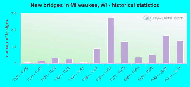
- New bridges - historical statistics
- 1Before 1900
- 61900-1909
- 161910-1919
- 331920-1929
- 271930-1939
- 51940-1949
- 891950-1959
- 2731960-1969
- 1301970-1979
- 371980-1989
- 511990-1999
- 1682000-2009
- 1382010-2019
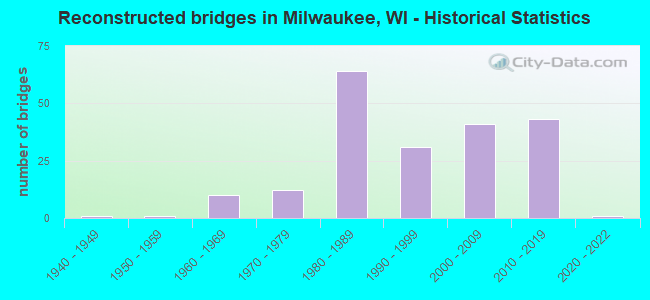
- Reconstructed bridges - Historical Statistics
- 11940-1949
- 11950-1959
- 101960-1969
- 121970-1979
- 641980-1989
- 311990-1999
- 412000-2009
- 432010-2019
- 12020-2022
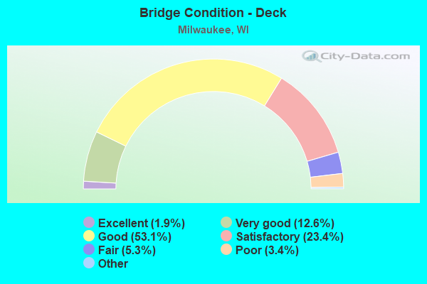
- Bridge Condition - Deck
- 1.9%Excellent
- 12.6%Very good
- 53.1%Good
- 23.4%Satisfactory
- 5.3%Fair
- 3.4%Poor
- 0.4%Serious
- 0.2%Failed
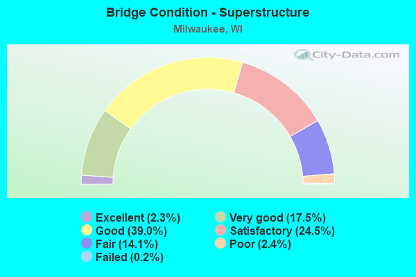
- Bridge Condition - Superstructure
- 2.3%Excellent
- 17.5%Very good
- 39.0%Good
- 24.5%Satisfactory
- 14.1%Fair
- 2.4%Poor
- 0.2%Failed
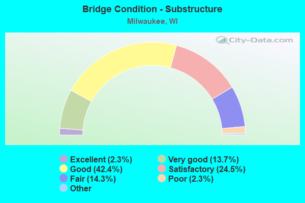
- Bridge Condition - Substructure
- 2.3%Excellent
- 13.7%Very good
- 42.4%Good
- 24.5%Satisfactory
- 14.3%Fair
- 2.3%Poor
- 0.6%Serious
- 0.2%Critical
- 0.2%Failed
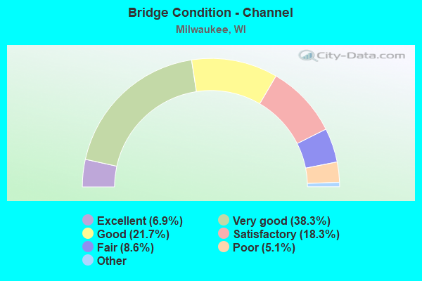
- Bridge Condition - Channel
- 6.9%Excellent
- 38.3%Very good
- 21.7%Good
- 18.3%Satisfactory
- 8.6%Fair
- 5.1%Poor
- 1.1%Serious
- 0.6%Failed
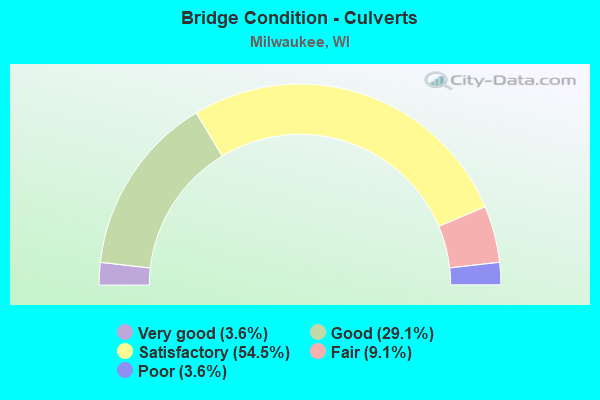
- Bridge Condition - Culverts
- 3.6%Very good
- 29.1%Good
- 54.5%Satisfactory
- 9.1%Fair
- 3.6%Poor
Find on map >> Show street view
Structure Number: B4005500004, Location: 0.8M N JCT STH 59 (Lat: 43.026236, Lng: -87.932903), Route carried "on" structure: City street , Year Built: 1929, Year Reconstructed: 1986, Status: Open, Structure Length: 6.40m (21.00ft), Average Daily Traffic: 13,800 (year 2019), Average Future Daily Traffic: 17,166 (year 2040), Design Load: HS 20, Features Intersected: LAND, Facility Carried by Structure: LRD S 16TH ST
Minimum Vertical Clearance: 30+ m (98+ ft), Kilometerpoint: 0.000, Lanes on structure: 4, Owner: City or Municipal Highway Agency, Approaching Roadway Width: 17.1m (56.1ft), Material/Design: Steel continuous, Design/Construction: Girder and Floorbeam System, Number Of Spans In Main Unit: 6, Length of Maximum Span: 13.7m (44.9ft), Curb or Sidewalk Widths: Left: 1.8m (5.9ft), Right: 1.8m (5.9ft), Curb-To-Curb Width: 17.1m (56.1ft), Out-to-Out Width: 21.3m (69.9ft)
Condition: Deck: Good, Superstructure: Fair, Substructure: Fair, Operating Rating: 55.5 metric tons, Method Used To Determine Operating Rating: Load Factor (LF), Inventory Rating: 35.6 metric tons, Method Used To Determine Inventory Rating: Load Factor (LF), Structural Evaluation: Somewhat better than minimum adequacy, Deck Geometry: Somewhat better than minimum adequacy, Approach Roadway Alignment: Equal to present desirable criteria, Designated Inspection Frequency: Every 24 months, Other Special Inspection Frequency: Every 72 months, Inspection Date: August 2021, Other Special Inspection Date: August 2017, Deck Structure Type: Concrete Cast-file-Place, Wearing Surface/Protective System: Wearing Surface: Monolithic Concrete, Deck Protection: Epoxy Coated Reinforcing
Find on map >> Show street view
Structure Number: B4005500005, Location: 0.8M N JCT STH 59 (Lat: 43.026814, Lng: -87.932908), Route carried "on" structure: City street , Year Built: 1929, Year Reconstructed: 1986, Status: Open, Structure Length: 11.43m (37.50ft), Average Daily Traffic: 13,800 (year 2019), Average Future Daily Traffic: 17,166 (year 2040), Design Load: HS 20, Features Intersected: CMSTP&P RR, Facility Carried by Structure: LRD S 16TH ST
Minimum Vertical Clearance: 30+ m (98+ ft), Kilometerpoint: 0.000, Lanes on structure: 4, Owner: City or Municipal Highway Agency, Approaching Roadway Width: 17.1m (56.1ft), Material/Design: Steel continuous, Design/Construction: Girder and Floorbeam System, Number Of Spans In Main Unit: 8, Length of Maximum Span: 18.3m (60.0ft), Curb or Sidewalk Widths: Left: 1.8m (5.9ft), Right: 1.8m (5.9ft), Curb-To-Curb Width: 17.1m (56.1ft), Out-to-Out Width: 21.3m (69.9ft)
Condition: Deck: Good, Superstructure: Fair, Substructure: Fair, Operating Rating: 55.5 metric tons, Method Used To Determine Operating Rating: Load Factor (LF), Inventory Rating: 35.6 metric tons, Method Used To Determine Inventory Rating: Load Factor (LF), Structural Evaluation: Somewhat better than minimum adequacy, Deck Geometry: Somewhat better than minimum adequacy, Underclear: Meets minimum limits, Approach Roadway Alignment: Equal to present desirable criteria, Designated Inspection Frequency: Every 24 months, Other Special Inspection Frequency: Every 72 months, Inspection Date: August 2021, Other Special Inspection Date: August 2017, Deck Structure Type: Concrete Cast-file-Place, Wearing Surface/Protective System: Wearing Surface: Monolithic Concrete, Deck Protection: Epoxy Coated Reinforcing
Find on map >> Show street view
Structure Number: B4005500006, Location: 0.8M N JCT STH 59 (Lat: 43.027844, Lng: -87.932897), Route carried "on" structure: City street , Year Built: 1929, Year Reconstructed: 1986, Status: Open, Structure Length: 7.32m (24.02ft), Average Daily Traffic: 13,800 (year 2019), Average Future Daily Traffic: 17,166 (year 2040), Design Load: HS 20, Features Intersected: CMSTP&P RR, Facility Carried by Structure: LRD S 16TH ST
Minimum Vertical Clearance: 30+ m (98+ ft), Kilometerpoint: 0.000, Lanes on structure: 4, Owner: City or Municipal Highway Agency, Approaching Roadway Width: 17.1m (56.1ft), Material/Design: Steel continuous, Design/Construction: Girder and Floorbeam System, Number Of Spans In Main Unit: 7, Length of Maximum Span: 18.3m (60.0ft), Curb or Sidewalk Widths: Left: 1.8m (5.9ft), Right: 1.8m (5.9ft), Curb-To-Curb Width: 17.1m (56.1ft), Out-to-Out Width: 21.3m (69.9ft)
Condition: Deck: Good, Superstructure: Fair, Substructure: Fair, Operating Rating: 55.5 metric tons, Method Used To Determine Operating Rating: Load Factor (LF), Inventory Rating: 35.6 metric tons, Method Used To Determine Inventory Rating: Load Factor (LF), Structural Evaluation: Somewhat better than minimum adequacy, Deck Geometry: Somewhat better than minimum adequacy, Underclear: Meets minimum limits, Approach Roadway Alignment: Equal to present desirable criteria, Designated Inspection Frequency: Every 24 months, Other Special Inspection Frequency: Every 72 months, Inspection Date: August 2021, Other Special Inspection Date: August 2017, Deck Structure Type: Concrete Cast-file-Place, Wearing Surface/Protective System: Wearing Surface: Monolithic Concrete, Deck Protection: Epoxy Coated Reinforcing
Find on map >> Show street view
Structure Number: B4005500007, Location: 0.8M N JCT STH 59 (Lat: 43.028483, Lng: -87.932894), Route carried "on" structure: City street , Year Built: 1929, Year Reconstructed: 1986, Status: Open, Structure Length: 6.40m (21.00ft), Average Daily Traffic: 13,800 (year 2019), Average Future Daily Traffic: 17,166 (year 2040), Design Load: HS 20, Features Intersected: LAND, Facility Carried by Structure: LRD S 16TH ST
Minimum Vertical Clearance: 30+ m (98+ ft), Kilometerpoint: 0.000, Lanes on structure: 4, Owner: City or Municipal Highway Agency, Approaching Roadway Width: 17.1m (56.1ft), Material/Design: Steel continuous, Design/Construction: Girder and Floorbeam System, Number Of Spans In Main Unit: 6, Length of Maximum Span: 13.7m (44.9ft), Curb or Sidewalk Widths: Left: 1.8m (5.9ft), Right: 1.8m (5.9ft), Curb-To-Curb Width: 17.1m (56.1ft), Out-to-Out Width: 21.3m (69.9ft)
Condition: Deck: Good, Superstructure: Satisfactory, Substructure: Fair, Operating Rating: 55.5 metric tons, Method Used To Determine Operating Rating: Load Factor (LF), Inventory Rating: 35.6 metric tons, Method Used To Determine Inventory Rating: Load Factor (LF), Structural Evaluation: Somewhat better than minimum adequacy, Deck Geometry: Somewhat better than minimum adequacy, Approach Roadway Alignment: Equal to present desirable criteria, Designated Inspection Frequency: Every 24 months, Other Special Inspection Frequency: Every 72 months, Inspection Date: August 2021, Other Special Inspection Date: August 2017, Deck Structure Type: Concrete Cast-file-Place, Wearing Surface/Protective System: Wearing Surface: Monolithic Concrete, Deck Protection: Epoxy Coated Reinforcing
Find on map >> Show street view
Structure Number: B4005500008, Location: 0.8M N JCT STH 59 (Lat: 43.029083, Lng: -87.932900), Route carried "on" structure: City street , Year Built: 1929, Year Reconstructed: 1986, Status: Open, Structure Length: 5.94m (19.49ft), Average Daily Traffic: 13,800 (year 2019), Average Future Daily Traffic: 17,166 (year 2040), Design Load: HS 20, Features Intersected: LAND, Facility Carried by Structure: LRD S 16TH ST
Minimum Vertical Clearance: 30+ m (98+ ft), Kilometerpoint: 0.000, Lanes on structure: 4, Owner: City or Municipal Highway Agency, Approaching Roadway Width: 17.1m (56.1ft), Material/Design: Steel continuous, Design/Construction: Girder and Floorbeam System, Number Of Spans In Main Unit: 5, Length of Maximum Span: 18.3m (60.0ft), Curb or Sidewalk Widths: Left: 1.8m (5.9ft), Right: 1.8m (5.9ft), Curb-To-Curb Width: 17.1m (56.1ft), Out-to-Out Width: 21.3m (69.9ft)
Condition: Deck: Good, Superstructure: Fair, Substructure: Fair, Operating Rating: 55.5 metric tons, Method Used To Determine Operating Rating: Load Factor (LF), Inventory Rating: 35.6 metric tons, Method Used To Determine Inventory Rating: Load Factor (LF), Structural Evaluation: Somewhat better than minimum adequacy, Deck Geometry: Somewhat better than minimum adequacy, Approach Roadway Alignment: Equal to present desirable criteria, Designated Inspection Frequency: Every 24 months, Other Special Inspection Frequency: Every 72 months, Inspection Date: August 2021, Other Special Inspection Date: August 2017, Deck Structure Type: Concrete Cast-file-Place, Wearing Surface/Protective System: Wearing Surface: Monolithic Concrete, Deck Protection: Epoxy Coated Reinforcing
Find on map >> Show street view
Structure Number: B4005500009, Location: 0.8M N JCT STH 59 (Lat: 43.029619, Lng: -87.932897), Route carried "on" structure: City street , Year Built: 1929, Year Reconstructed: 1986, Status: Open, Structure Length: 6.86m (22.51ft), Average Daily Traffic: 13,800 (year 2019), Average Future Daily Traffic: 17,166 (year 2040), Design Load: HS 20, Features Intersected: LAND, Facility Carried by Structure: LRD S 16TH ST
Minimum Vertical Clearance: 30+ m (98+ ft), Kilometerpoint: 0.000, Lanes on structure: 4, Owner: City or Municipal Highway Agency, Approaching Roadway Width: 17.1m (56.1ft), Material/Design: Steel continuous, Design/Construction: Girder and Floorbeam System, Number Of Spans In Main Unit: 6, Length of Maximum Span: 17.4m (57.1ft), Curb or Sidewalk Widths: Left: 1.8m (5.9ft), Right: 1.8m (5.9ft), Curb-To-Curb Width: 17.1m (56.1ft), Out-to-Out Width: 21.3m (69.9ft)
Condition: Deck: Good, Superstructure: Fair, Substructure: Fair, Operating Rating: 55.5 metric tons, Method Used To Determine Operating Rating: Load Factor (LF), Inventory Rating: 35.6 metric tons, Method Used To Determine Inventory Rating: Load Factor (LF), Structural Evaluation: Somewhat better than minimum adequacy, Deck Geometry: Somewhat better than minimum adequacy, Approach Roadway Alignment: Equal to present desirable criteria, Designated Inspection Frequency: Every 24 months, Other Special Inspection Frequency: Every 72 months, Inspection Date: August 2021, Other Special Inspection Date: August 2017, Deck Structure Type: Concrete Cast-file-Place, Wearing Surface/Protective System: Wearing Surface: Monolithic Concrete, Deck Protection: Epoxy Coated Reinforcing
Find on map >> Show street view
Structure Number: B400550001, Location: 0.8M N JCT STH 59 (Lat: 43.030233, Lng: -87.932894), Route carried "on" structure: City street , Year Built: 1929, Year Reconstructed: 1986, Status: Open, Structure Length: 7.77m (25.49ft), Average Daily Traffic: 13,800 (year 2019), Average Future Daily Traffic: 17,166 (year 2040), Design Load: HS 20, Features Intersected: LAND, Facility Carried by Structure: LRD S 16TH ST
Minimum Vertical Clearance: 30+ m (98+ ft), Kilometerpoint: 0.000, Lanes on structure: 4, Owner: City or Municipal Highway Agency, Approaching Roadway Width: 17.1m (56.1ft), Material/Design: Steel continuous, Design/Construction: Girder and Floorbeam System, Number Of Spans In Main Unit: 6, Length of Maximum Span: 13.7m (44.9ft), Curb or Sidewalk Widths: Left: 1.8m (5.9ft), Right: 1.8m (5.9ft), Curb-To-Curb Width: 17.1m (56.1ft), Out-to-Out Width: 21.3m (69.9ft)
Condition: Deck: Good, Superstructure: Fair, Substructure: Fair, Operating Rating: 55.5 metric tons, Method Used To Determine Operating Rating: Load Factor (LF), Inventory Rating: 35.6 metric tons, Method Used To Determine Inventory Rating: Load Factor (LF), Structural Evaluation: Somewhat better than minimum adequacy, Deck Geometry: Somewhat better than minimum adequacy, Approach Roadway Alignment: Equal to present desirable criteria, Designated Inspection Frequency: Every 24 months, Other Special Inspection Frequency: Every 96 months, Inspection Date: August 2021, Other Special Inspection Date: August 2017, Deck Structure Type: Concrete Cast-file-Place, Wearing Surface/Protective System: Wearing Surface: Monolithic Concrete, Deck Protection: Epoxy Coated Reinforcing
Find on map >> Show street view
Structure Number: B4005500011, Location: 0.8M N JCT STH 59 (Lat: 43.030931, Lng: -87.932892), Route carried "on" structure: City street , Year Built: 1929, Year Reconstructed: 1986, Status: Open, Structure Length: 5.02m (16.47ft), Average Daily Traffic: 13,800 (year 2019), Average Future Daily Traffic: 17,166 (year 2040), Design Load: HS 20, Features Intersected: LAND, Facility Carried by Structure: LRD S 16TH ST
Minimum Vertical Clearance: 30+ m (98+ ft), Kilometerpoint: 0.000, Lanes on structure: 4, Owner: City or Municipal Highway Agency, Approaching Roadway Width: 17.1m (56.1ft), Material/Design: Steel continuous, Design/Construction: Girder and Floorbeam System, Number Of Spans In Main Unit: 5, Length of Maximum Span: 13.7m (44.9ft), Curb or Sidewalk Widths: Left: 1.8m (5.9ft), Right: 1.8m (5.9ft), Curb-To-Curb Width: 17.1m (56.1ft), Out-to-Out Width: 21.3m (69.9ft)
Condition: Deck: Good, Superstructure: Satisfactory, Substructure: Satisfactory, Operating Rating: 55.5 metric tons, Method Used To Determine Operating Rating: Load Factor (LF), Inventory Rating: 35.6 metric tons, Method Used To Determine Inventory Rating: Load Factor (LF), Structural Evaluation: Equal to present minimum criteria, Deck Geometry: Somewhat better than minimum adequacy, Approach Roadway Alignment: Equal to present desirable criteria, Designated Inspection Frequency: Every 24 months, Other Special Inspection Frequency: Every 72 months, Inspection Date: August 2021, Other Special Inspection Date: August 2017, Deck Structure Type: Concrete Cast-file-Place, Wearing Surface/Protective System: Wearing Surface: Monolithic Concrete, Deck Protection: Epoxy Coated Reinforcing
Find on map >> Show street view
Structure Number: B4005500012, Location: 0.8M N JCT STH 59 (Lat: 43.031386, Lng: -87.932892), Route carried "on" structure: City street , Year Built: 1929, Year Reconstructed: 1986, Status: Open, Structure Length: 4.13m (13.55ft), Average Daily Traffic: 7,500 (year 2018), Average Future Daily Traffic: 17,166 (year 2040), Design Load: HS 20, Features Intersected: LRD CANAL ST & CMSTP&P R, Facility Carried by Structure: LRD S 16TH ST
Minimum Vertical Clearance: 30+ m (98+ ft), Kilometerpoint: 0.000, Lanes on structure: 4, Owner: City or Municipal Highway Agency, Approaching Roadway Width: 17.1m (56.1ft), Material/Design: Steel continuous, Design/Construction: Girder and Floorbeam System, Number Of Spans In Main Unit: 4, Length of Maximum Span: 21.9m (71.9ft), Curb or Sidewalk Widths: Left: 1.8m (5.9ft), Right: 1.8m (5.9ft), Curb-To-Curb Width: 17.1m (56.1ft), Out-to-Out Width: 21.3m (69.9ft)
Condition: Deck: Good, Superstructure: Fair, Substructure: Fair, Operating Rating: 55.5 metric tons, Method Used To Determine Operating Rating: Load Factor (LF), Inventory Rating: 35.6 metric tons, Method Used To Determine Inventory Rating: Load Factor (LF), Structural Evaluation: Somewhat better than minimum adequacy, Deck Geometry: Somewhat better than minimum adequacy, Underclear: Meets minimum limits, Approach Roadway Alignment: Equal to present desirable criteria, Designated Inspection Frequency: Every 24 months, Other Special Inspection Frequency: Every 72 months, Inspection Date: August 2021, Other Special Inspection Date: August 2017, Deck Structure Type: Concrete Cast-file-Place, Wearing Surface/Protective System: Wearing Surface: Monolithic Concrete, Deck Protection: Epoxy Coated Reinforcing
Find on map >> Show street view
Structure Number: B4005500013, Location: 0.8M N JCT STH 59 (Lat: 43.031761, Lng: -87.932889), Route carried "on" structure: City street , Year Built: 1929, Year Reconstructed: 1986, Status: Open, Structure Length: 6.43m (21.10ft), Average Daily Traffic: 13,800 (year 2019), Average Future Daily Traffic: 17,166 (year 2040), Design Load: HS 20, Features Intersected: LAND, Facility Carried by Structure: LRD S 16TH ST
Minimum Vertical Clearance: 30+ m (98+ ft), Kilometerpoint: 0.000, Lanes on structure: 4, Owner: City or Municipal Highway Agency, Approaching Roadway Width: 17.1m (56.1ft), Material/Design: Steel continuous, Design/Construction: Girder and Floorbeam System, Number Of Spans In Main Unit: 4, Length of Maximum Span: 20.5m (67.3ft), Curb or Sidewalk Widths: Left: 1.8m (5.9ft), Right: 1.8m (5.9ft), Curb-To-Curb Width: 17.1m (56.1ft), Out-to-Out Width: 21.3m (69.9ft)
Condition: Deck: Good, Superstructure: Fair, Substructure: Satisfactory, Operating Rating: 55.5 metric tons, Method Used To Determine Operating Rating: Load Factor (LF), Inventory Rating: 35.6 metric tons, Method Used To Determine Inventory Rating: Load Factor (LF), Structural Evaluation: Somewhat better than minimum adequacy, Deck Geometry: Somewhat better than minimum adequacy, Approach Roadway Alignment: Equal to present desirable criteria, Designated Inspection Frequency: Every 24 months, Other Special Inspection Frequency: Every 72 months, Inspection Date: August 2021, Other Special Inspection Date: August 2017, Deck Structure Type: Concrete Cast-file-Place, Wearing Surface/Protective System: Wearing Surface: Monolithic Concrete, Deck Protection: Epoxy Coated Reinforcing
Find on map >> Show street view
Structure Number: B4005500014, Location: 0.8M N JCT STH 59 (Lat: 43.032339, Lng: -87.932881), Route carried "on" structure: City street , Year Built: 1929, Year Reconstructed: 1986, Status: Open, Structure Length: 11.70m (38.39ft), Average Daily Traffic: 13,800 (year 2019), Average Future Daily Traffic: 17,166 (year 2040), Design Load: HS 20, Features Intersected: MENOMONEE RIVER, Facility Carried by Structure: LRD N 16TH ST
Minimum Vertical Clearance: 30+ m (98+ ft), Kilometerpoint: 0.000, Lanes on structure: 4, Owner: City or Municipal Highway Agency, Approaching Roadway Width: 17.1m (56.1ft), Material/Design: Steel continuous, Design/Construction: Girder and Floorbeam System, Number Of Spans In Main Unit: 1, Number Of Approach Spans: 3, Length of Maximum Span: 45.7m (149.9ft), Curb or Sidewalk Widths: Left: 2.1m (6.9ft), Right: 2.1m (6.9ft), Curb-To-Curb Width: 17.1m (56.1ft), Out-to-Out Width: 21.9m (71.9ft)
Condition: Deck: Satisfactory, Superstructure: Poor, Substructure: Poor, Channel: Good, Operating Rating: 55.5 metric tons, Method Used To Determine Operating Rating: Load Factor (LF), Inventory Rating: 32.4 metric tons, Method Used To Determine Inventory Rating: Load Factor (LF), Structural Evaluation: Meets minimum limits, Deck Geometry: Somewhat better than minimum adequacy, Waterway Adequacy: Equal to present desirable criteria, Approach Roadway Alignment: Equal to present desirable criteria, Length Of Structure Improvement: 12.16m (39.90ft), Designated Inspection Frequency: Every 12 months, Underwater Inspection Frequency: Every 60 months, Other Special Inspection Frequency: Every 24 months, Inspection Date: May 2021, Underwater Inspection Date: June 2018, Other Special Inspection Date: May 2021, Bridge Improvement Cost: $1,939,000, Roadway Improvement Cost: $193,000, Total Project Cost: $2,908,000 ( Estimate for 2021), Deck Structure Type: Concrete Cast-file-Place, Wearing Surface/Protective System: Wearing Surface: Monolithic Concrete, Deck Protection: Epoxy Coated Reinforcing
Find on map >> Show street view
Structure Number: B4005500015, Location: 0.8M N JCT STH 59 (Lat: 43.033389, Lng: -87.932889), Route carried "on" structure: City street , Year Built: 1929, Year Reconstructed: 1986, Status: Open, Structure Length: 7.13m (23.39ft), Average Daily Traffic: 8,700 (year 2018), Average Future Daily Traffic: 17,166 (year 2040), Design Load: HS 20, Features Intersected: LAND, Facility Carried by Structure: LRD S 16TH ST
Minimum Vertical Clearance: 30+ m (98+ ft), Kilometerpoint: 0.000, Lanes on structure: 4, Owner: City or Municipal Highway Agency, Approaching Roadway Width: 17.1m (56.1ft), Material/Design: Steel continuous, Design/Construction: Girder and Floorbeam System, Number Of Spans In Main Unit: 6, Length of Maximum Span: 18.3m (60.0ft), Curb or Sidewalk Widths: Left: 1.8m (5.9ft), Right: 1.8m (5.9ft), Curb-To-Curb Width: 17.1m (56.1ft), Out-to-Out Width: 21.3m (69.9ft)
Condition: Deck: Good, Superstructure: Fair, Substructure: Satisfactory, Operating Rating: 55.5 metric tons, Method Used To Determine Operating Rating: Load Factor (LF), Inventory Rating: 35.6 metric tons, Method Used To Determine Inventory Rating: Load Factor (LF), Structural Evaluation: Somewhat better than minimum adequacy, Deck Geometry: Somewhat better than minimum adequacy, Approach Roadway Alignment: Equal to present desirable criteria, Designated Inspection Frequency: Every 24 months, Other Special Inspection Frequency: Every 72 months, Inspection Date: August 2021, Other Special Inspection Date: August 2017, Deck Structure Type: Concrete Cast-file-Place, Wearing Surface/Protective System: Wearing Surface: Monolithic Concrete, Deck Protection: Epoxy Coated Reinforcing
Find on map >> Show street view
Structure Number: B4005500016, Location: 0.8M N JCT STH 59 (Lat: 43.034033, Lng: -87.932878), Route carried "on" structure: City street , Year Built: 1929, Year Reconstructed: 1986, Status: Open, Structure Length: 6.52m (21.39ft), Average Daily Traffic: 8,700 (year 2018), Average Future Daily Traffic: 17,166 (year 2040), Design Load: HS 20, Features Intersected: CMSTP&P RR, Facility Carried by Structure: LRD S 16TH ST
Minimum Vertical Clearance: 30+ m (98+ ft), Kilometerpoint: 0.000, Lanes on structure: 4, Owner: City or Municipal Highway Agency, Approaching Roadway Width: 17.1m (56.1ft), Material/Design: Steel continuous, Design/Construction: Girder and Floorbeam System, Number Of Spans In Main Unit: 6, Length of Maximum Span: 21.1m (69.2ft), Curb or Sidewalk Widths: Left: 1.8m (5.9ft), Right: 1.8m (5.9ft), Curb-To-Curb Width: 17.1m (56.1ft), Out-to-Out Width: 21.3m (69.9ft)
Condition: Deck: Good, Superstructure: Fair, Substructure: Satisfactory, Operating Rating: 55.5 metric tons, Method Used To Determine Operating Rating: Load Factor (LF), Inventory Rating: 35.6 metric tons, Method Used To Determine Inventory Rating: Load Factor (LF), Structural Evaluation: Somewhat better than minimum adequacy, Deck Geometry: Somewhat better than minimum adequacy, Underclear: Meets minimum limits, Approach Roadway Alignment: Equal to present desirable criteria, Designated Inspection Frequency: Every 24 months, Other Special Inspection Frequency: Every 72 months, Inspection Date: August 2021, Other Special Inspection Date: August 2017, Deck Structure Type: Concrete Cast-file-Place, Wearing Surface/Protective System: Wearing Surface: Monolithic Concrete, Deck Protection: Epoxy Coated Reinforcing
Find on map >> Show street view
Structure Number: B4005500017, Location: 0.8M N JCT STH 59 (Lat: 43.034622, Lng: -87.932875), Route carried "on" structure: City street , Year Built: 1929, Year Reconstructed: 1986, Status: Open, Structure Length: 7.22m (23.69ft), Average Daily Traffic: 8,700 (year 2018), Average Future Daily Traffic: 17,166 (year 2040), Design Load: HS 20, Features Intersected: ST PAUL AVE & BUILDINGS, Facility Carried by Structure: LRD S 16TH ST
Minimum Vertical Clearance: 30+ m (98+ ft), Kilometerpoint: 0.000, Lanes on structure: 4, Owner: City or Municipal Highway Agency, Approaching Roadway Width: 17.1m (56.1ft), Material/Design: Steel continuous, Design/Construction: Girder and Floorbeam System, Number Of Spans In Main Unit: 6, Length of Maximum Span: 21.9m (71.9ft), Curb or Sidewalk Widths: Left: 1.8m (5.9ft), Right: 1.8m (5.9ft), Curb-To-Curb Width: 17.1m (56.1ft), Out-to-Out Width: 21.3m (69.9ft)
Condition: Deck: Good, Superstructure: Satisfactory, Substructure: Satisfactory, Operating Rating: 55.5 metric tons, Method Used To Determine Operating Rating: Load Factor (LF), Inventory Rating: 35.6 metric tons, Method Used To Determine Inventory Rating: Load Factor (LF), Structural Evaluation: Equal to present minimum criteria, Deck Geometry: Somewhat better than minimum adequacy, Approach Roadway Alignment: Equal to present desirable criteria, Designated Inspection Frequency: Every 24 months, Other Special Inspection Frequency: Every 72 months, Inspection Date: August 2021, Other Special Inspection Date: August 2017, Deck Structure Type: Concrete Cast-file-Place, Wearing Surface/Protective System: Wearing Surface: Monolithic Concrete, Deck Protection: Epoxy Coated Reinforcing
Find on map >> Show street view
Structure Number: B4005500018, Location: 0.8M N JCT STH 59 (Lat: 43.035442, Lng: -87.932828), Route carried "on" structure: City street , Year Built: 1929, Year Reconstructed: 1986, Status: Open, Structure Length: 8.44m (27.69ft), Average Daily Traffic: 8,700 (year 2018), Truck Traffic: 5%, Average Future Daily Traffic: 16,300 (year 2040), Design Load: HS 25 or greater, Features Intersected: IH 94 E-W FREEWAY, Facility Carried by Structure: LRD N 16TH ST
Minimum Vertical Clearance: 30+ m (98+ ft), Kilometerpoint: 0.000, Lanes on structure: 5, Lanes under structure: 10, Owner: State Highway Agency, Approaching Roadway Width: 17.1m (56.1ft), Material/Design: Steel continuous, Design/Construction: Stringer/Multi-beam, Number Of Spans In Main Unit: 4, Length of Maximum Span: 33.1m (108.6ft), Curb or Sidewalk Widths: Left: 2.0m (6.6ft), Right: 2.0m (6.6ft), Curb-To-Curb Width: 17.1m (56.1ft), Out-to-Out Width: 21.3m (69.9ft)
Condition: Deck: Satisfactory, Superstructure: Satisfactory, Substructure: Fair, Operating Rating: 80.0 metric tons, Method Used To Determine Operating Rating: Load Factor (LF), Inventory Rating: 40.5 metric tons, Method Used To Determine Inventory Rating: Load Factor (LF), Structural Evaluation: Somewhat better than minimum adequacy, Deck Geometry: High priority of replacement, Underclear: High priority of replacement, Approach Roadway Alignment: Equal to present desirable criteria, Length Of Structure Improvement: 8.87m (29.10ft), Designated Inspection Frequency: Every 24 months, Inspection Date: June 2021, Bridge Improvement Cost: $1,261,000, Roadway Improvement Cost: $126,000, Total Project Cost: $1,891,000 ( Estimate for 2021), Deck Structure Type: Concrete Cast-file-Place, Wearing Surface/Protective System: Wearing Surface: Low Slump Concrete, Deck Protection: Epoxy Coated Reinforcing
Find on map >> Show street view
Structure Number: B400550010A, Location: 0.8M N JCT STH 59 (Lat: 43.030489, Lng: -87.932892), Route carried "on" structure: City street , Year Built: 1929, Year Reconstructed: 1979, Status: Open, Structure Length: 2.96m (9.71ft), Average Daily Traffic: 5,900 (year 2018), Average Future Daily Traffic: 6,229 (year 2040), Design Load: HS 20, Features Intersected: LAND, Facility Carried by Structure: LRD S 16TH ST RAMP
Minimum Vertical Clearance: 30+ m (98+ ft), Kilometerpoint: 0.000, Lanes on structure: 3, Owner: City or Municipal Highway Agency, Approaching Roadway Width: 11.6m (38.1ft), Material/Design: Steel continuous, Design/Construction: Girder and Floorbeam System, Number Of Spans In Main Unit: 4, Length of Maximum Span: 9.1m (29.9ft), Curb or Sidewalk Widths: Left: 0.0m, Right: 2.0m (6.6ft), Curb-To-Curb Width: 11.6m (38.1ft), Out-to-Out Width: 14.5m (47.6ft)
Condition: Deck: Satisfactory, Superstructure: Satisfactory, Substructure: Good, Operating Rating: 58.8 metric tons, Method Used To Determine Operating Rating: Load Factor (LF), Inventory Rating: 35.6 metric tons, Method Used To Determine Inventory Rating: Load Factor (LF), Structural Evaluation: Equal to present minimum criteria, Deck Geometry: High priority of replacement, Approach Roadway Alignment: Equal to present desirable criteria, Length Of Structure Improvement: 3.41m (11.19ft), Designated Inspection Frequency: Every 24 months, Other Special Inspection Frequency: Every 72 months, Inspection Date: August 2021, Other Special Inspection Date: August 2017, Bridge Improvement Cost: $544,000, Roadway Improvement Cost: $54,000, Total Project Cost: $816,000 ( Estimate for 2021), Deck Structure Type: Concrete Cast-file-Place, Wearing Surface/Protective System: Wearing Surface: Monolithic Concrete, Deck Protection: Epoxy Coated Reinforcing
Find on map >> Show street view
Structure Number: B400550010B, Location: 0.8M N JCT STH 59 (Lat: 43.030558, Lng: -87.932558), Route carried "on" structure: City street , Year Built: 1929, Year Reconstructed: 1979, Status: Open, Structure Length: 3.66m (12.01ft), Average Daily Traffic: 5,900 (year 2018), Average Future Daily Traffic: 6,229 (year 2040), Design Load: HS 20, Features Intersected: LAND, Facility Carried by Structure: LRD S 16TH ST RAMP
Minimum Vertical Clearance: 30+ m (98+ ft), Kilometerpoint: 0.000, Lanes on structure: 3, Owner: City or Municipal Highway Agency, Approaching Roadway Width: 11.6m (38.1ft), Material/Design: Steel continuous, Design/Construction: Girder and Floorbeam System, Number Of Spans In Main Unit: 4, Length of Maximum Span: 9.1m (29.9ft), Curb or Sidewalk Widths: Left: 0.0m, Right: 2.0m (6.6ft), Curb-To-Curb Width: 11.6m (38.1ft), Out-to-Out Width: 14.5m (47.6ft)
Condition: Deck: Satisfactory, Superstructure: Satisfactory, Substructure: Good, Operating Rating: 58.8 metric tons, Method Used To Determine Operating Rating: Load Factor (LF), Inventory Rating: 35.6 metric tons, Method Used To Determine Inventory Rating: Load Factor (LF), Structural Evaluation: Equal to present minimum criteria, Deck Geometry: High priority of replacement, Approach Roadway Alignment: Equal to present desirable criteria, Length Of Structure Improvement: 4.11m (13.48ft), Designated Inspection Frequency: Every 24 months, Other Special Inspection Frequency: Every 72 months, Inspection Date: August 2021, Other Special Inspection Date: August 2017, Bridge Improvement Cost: $656,000, Roadway Improvement Cost: $65,000, Total Project Cost: $984,000 ( Estimate for 2021), Deck Structure Type: Concrete Cast-file-Place, Wearing Surface/Protective System: Wearing Surface: Monolithic Concrete, Deck Protection: Epoxy Coated Reinforcing
Find on map >> Show street view
Structure Number: B400550010C, Location: 0.8M N JCT STH 59 (Lat: 43.030533, Lng: -87.932108), Route carried "on" structure: City street , Year Built: 1929, Year Reconstructed: 1979, Status: Open, Structure Length: 3.66m (12.01ft), Average Daily Traffic: 5,900 (year 2018), Average Future Daily Traffic: 6,229 (year 2040), Design Load: HS 20, Features Intersected: LAND, Facility Carried by Structure: LRD S 16TH ST RAMP
Minimum Vertical Clearance: 30+ m (98+ ft), Kilometerpoint: 0.000, Lanes on structure: 3, Owner: City or Municipal Highway Agency, Approaching Roadway Width: 11.6m (38.1ft), Material/Design: Steel continuous, Design/Construction: Girder and Floorbeam System, Number Of Spans In Main Unit: 4, Length of Maximum Span: 9.1m (29.9ft), Curb or Sidewalk Widths: Left: 0.0m, Right: 2.0m (6.6ft), Curb-To-Curb Width: 11.6m (38.1ft), Out-to-Out Width: 14.5m (47.6ft)
Condition: Deck: Satisfactory, Superstructure: Satisfactory, Substructure: Good, Operating Rating: 58.8 metric tons, Method Used To Determine Operating Rating: Load Factor (LF), Inventory Rating: 35.6 metric tons, Method Used To Determine Inventory Rating: Load Factor (LF), Structural Evaluation: Equal to present minimum criteria, Deck Geometry: High priority of replacement, Approach Roadway Alignment: Equal to present desirable criteria, Length Of Structure Improvement: 4.11m (13.48ft), Designated Inspection Frequency: Every 24 months, Other Special Inspection Frequency: Every 72 months, Inspection Date: August 2021, Other Special Inspection Date: August 2017, Bridge Improvement Cost: $656,000, Roadway Improvement Cost: $65,000, Total Project Cost: $984,000 ( Estimate for 2021), Deck Structure Type: Concrete Cast-file-Place, Wearing Surface/Protective System: Wearing Surface: Monolithic Concrete, Deck Protection: Epoxy Coated Reinforcing
Find on map >> Show street view
Structure Number: B400550010D, Location: 0.8M N JCT STH 59 (Lat: 43.030522, Lng: -87.931661), Route carried "on" structure: City street , Year Built: 1929, Year Reconstructed: 1979, Status: Open, Structure Length: 1.87m (6.14ft), Average Daily Traffic: 5,900 (year 2018), Average Future Daily Traffic: 6,232 (year 2040), Design Load: HS 20, Features Intersected: LAND, Facility Carried by Structure: LRD S 16TH ST RAMP
Minimum Vertical Clearance: 30+ m (98+ ft), Kilometerpoint: 0.000, Lanes on structure: 3, Owner: City or Municipal Highway Agency, Approaching Roadway Width: 11.6m (38.1ft), Material/Design: Steel continuous, Design/Construction: Girder and Floorbeam System, Number Of Spans In Main Unit: 2, Length of Maximum Span: 9.1m (29.9ft), Curb or Sidewalk Widths: Left: 0.0m, Right: 2.0m (6.6ft), Curb-To-Curb Width: 11.6m (38.1ft), Out-to-Out Width: 14.5m (47.6ft)
Condition: Deck: Good, Superstructure: Satisfactory, Substructure: Good, Operating Rating: 58.8 metric tons, Method Used To Determine Operating Rating: Load Factor (LF), Inventory Rating: 35.6 metric tons, Method Used To Determine Inventory Rating: Load Factor (LF), Structural Evaluation: Equal to present minimum criteria, Deck Geometry: High priority of replacement, Approach Roadway Alignment: Equal to present desirable criteria, Length Of Structure Improvement: 2.32m (7.61ft), Designated Inspection Frequency: Every 24 months, Other Special Inspection Frequency: Every 72 months, Inspection Date: August 2021, Other Special Inspection Date: August 2017, Bridge Improvement Cost: $371,000, Roadway Improvement Cost: $37,000, Total Project Cost: $557,000 ( Estimate for 2021), Deck Structure Type: Concrete Cast-file-Place, Wearing Surface/Protective System: Wearing Surface: Monolithic Concrete, Deck Protection: Epoxy Coated Reinforcing
Find on map >> Show street view
Structure Number: B400551, Location: 0.9M W JCT STH 57 (Lat: 43.048664, Lng: -87.955850), Route carried "on" structure: City street , Year Built: 1988, Status: Open, Structure Length: 3.11m (10.20ft), Average Daily Traffic: 8,901 (year 2019), Average Future Daily Traffic: 11,722 (year 2039), Design Load: HS 20, Features Intersected: CANADIAN PACIFIC RR, Facility Carried by Structure: LRD W VLIET ST
Minimum Vertical Clearance: 30+ m (98+ ft), Kilometerpoint: 0.000, Lanes on structure: 2, Owner: City or Municipal Highway Agency, Approaching Roadway Width: 15.2m (49.9ft), Skew: 5 degrees, Material/Design: Concrete, Design/Construction: Frame, Number Of Spans In Main Unit: 1, Length of Maximum Span: 20.1m (65.9ft), Curb or Sidewalk Widths: Left: 2.3m (7.5ft), Right: 2.3m (7.5ft), Curb-To-Curb Width: 15.2m (49.9ft), Out-to-Out Width: 19.8m (65.0ft)
Condition: Deck: Satisfactory, Superstructure: Satisfactory, Substructure: Good, Operating Rating: 44.1 metric tons, Method Used To Determine Operating Rating: Load Factor (LF), Inventory Rating: 32.4 metric tons, Method Used To Determine Inventory Rating: Load Factor (LF), Structural Evaluation: Equal to present minimum criteria, Deck Geometry: Superior to present desirable criteria, Underclear: Meets minimum limits, Approach Roadway Alignment: Equal to present desirable criteria, Designated Inspection Frequency: Every 24 months, Inspection Date: September 2020, Deck Structure Type: Concrete Cast-file-Place, Wearing Surface/Protective System: Wearing Surface: Epoxy Overlay, Deck Protection: Epoxy Coated Reinforcing
Find on map >> Show street view
Structure Number: B400555, Location: 1.9M S JCT STH 59 (Lat: 42.993647, Lng: -87.933619), Route carried "on" structure: City street , Year Built: 1986, Status: Open, Structure Length: 2.17m (7.12ft), Average Daily Traffic: 9,915 (year 2019), Average Future Daily Traffic: 7,918 (year 2039), Design Load: HS 20, Features Intersected: UP RR, Facility Carried by Structure: LRD S 16TH ST
Minimum Vertical Clearance: 30+ m (98+ ft), Kilometerpoint: 0.000, Lanes on structure: 4, Owner: City or Municipal Highway Agency, Approaching Roadway Width: 15.2m (49.9ft), Material/Design: Prestressed concrete, Design/Construction: Stringer/Multi-beam, Number Of Spans In Main Unit: 1, Length of Maximum Span: 19.9m (65.3ft), Curb or Sidewalk Widths: Left: 2.0m (6.6ft), Right: 2.0m (6.6ft), Curb-To-Curb Width: 15.2m (49.9ft), Out-to-Out Width: 20.1m (65.9ft)
Condition: Deck: Satisfactory, Superstructure: Good, Substructure: Satisfactory, Operating Rating: 71.8 metric tons, Method Used To Determine Operating Rating: Load Factor (LF), Inventory Rating: 34.0 metric tons, Method Used To Determine Inventory Rating: Load Factor (LF), Structural Evaluation: Equal to present minimum criteria, Deck Geometry: High priority of corrective action, Underclear: High priority of replacement, Approach Roadway Alignment: Equal to present desirable criteria, Length Of Structure Improvement: 2.62m (8.60ft), Designated Inspection Frequency: Every 24 months, Inspection Date: September 2020, Bridge Improvement Cost: $371,000, Roadway Improvement Cost: $37,000, Total Project Cost: $557,000 ( Estimate for 2021), Deck Structure Type: Concrete Cast-file-Place, Wearing Surface/Protective System: Wearing Surface: Monolithic Concrete, Deck Protection: Epoxy Coated Reinforcing
Find on map >> Show street view
Structure Number: B400556, Location: 0.3M N JCT OKLAHOMA AVE (Lat: 42.993333, Lng: -87.938333), Route carried "on" structure: City street , Year Built: 1987, Status: Open, Structure Length: 2.09m (6.86ft), Average Daily Traffic: 11,200 (year 2019), Average Future Daily Traffic: 8,907 (year 2039), Design Load: HS 20, Features Intersected: UP RR, Facility Carried by Structure: LRD S 20TH ST
Minimum Vertical Clearance: 30+ m (98+ ft), Kilometerpoint: 0.000, Lanes on structure: 2, Owner: City or Municipal Highway Agency, Approaching Roadway Width: 12.2m (40.0ft), Material/Design: Prestressed concrete, Design/Construction: Stringer/Multi-beam, Number Of Spans In Main Unit: 1, Length of Maximum Span: 20.0m (65.6ft), Curb or Sidewalk Widths: Left: 2.0m (6.6ft), Right: 1.0m (3.3ft), Curb-To-Curb Width: 12.2m (40.0ft), Out-to-Out Width: 15.5m (50.9ft)
Condition: Deck: Satisfactory, Superstructure: Satisfactory, Substructure: Satisfactory, Operating Rating: 68.6 metric tons, Method Used To Determine Operating Rating: Load Factor (LF), Inventory Rating: 34.0 metric tons, Method Used To Determine Inventory Rating: Load Factor (LF), Structural Evaluation: Equal to present minimum criteria, Deck Geometry: Somewhat better than minimum adequacy, Underclear: Somewhat better than minimum adequacy, Approach Roadway Alignment: Equal to present desirable criteria, Designated Inspection Frequency: Every 24 months, Inspection Date: September 2020, Deck Structure Type: Concrete Cast-file-Place, Wearing Surface/Protective System: Wearing Surface: Monolithic Concrete, Deck Protection: Epoxy Coated Reinforcing
Find on map >> Show street view
Structure Number: B400558, Location: 0.7M W JCT STH 32 (Lat: 43.066122, Lng: -87.891033), Route carried "on" structure: City street , Year Built: 1995, Status: Open, Structure Length: 2.34m (7.68ft), Average Daily Traffic: 621 (year 2019), Average Future Daily Traffic: 683 (year 2039), Design Load: HS 20, Features Intersected: OAK LEAF BIKE TRAIL, Facility Carried by Structure: LRD E BELLEVIEW PL
Minimum Vertical Clearance: 30+ m (98+ ft), Kilometerpoint: 0.000, Lanes on structure: 2, Owner: County Highway Agency, Approaching Roadway Width: 9.1m (29.9ft), Material/Design: Steel, Design/Construction: Stringer/Multi-beam, Number Of Spans In Main Unit: 1, Length of Maximum Span: 22.4m (73.5ft), Curb or Sidewalk Widths: Left: 1.8m (5.9ft), Right: 1.8m (5.9ft), Curb-To-Curb Width: 9.1m (29.9ft), Out-to-Out Width: 13.5m (44.3ft)
Condition: Deck: Good, Superstructure: Good, Substructure: Satisfactory, Operating Rating: 63.7 metric tons, Method Used To Determine Operating Rating: Load Factor (LF), Inventory Rating: 37.3 metric tons, Method Used To Determine Inventory Rating: Load Factor (LF), Structural Evaluation: Equal to present minimum criteria, Deck Geometry: Equal to present minimum criteria, Approach Roadway Alignment: Equal to present desirable criteria, Designated Inspection Frequency: Every 24 months, Inspection Date: May 2020, Deck Structure Type: Concrete Cast-file-Place, Wearing Surface/Protective System: Wearing Surface: Monolithic Concrete, Deck Protection: Epoxy Coated Reinforcing
Find on map >> Show street view
Structure Number: B400559, Location: 0.1M E JCT STH 32 (Lat: 43.055703, Lng: -87.886450), Route carried "on" structure: City street , Year Built: 1990, Status: Open, Structure Length: 2.29m (7.51ft), Average Daily Traffic: 6,800 (year 2019), Truck Traffic: 1%, Average Future Daily Traffic: 7,667 (year 2039), Design Load: HS 20, Features Intersected: BIKE TRAIL, Facility Carried by Structure: LRD E LAFAYETTE PL
Minimum Vertical Clearance: 30+ m (98+ ft), Kilometerpoint: 0.000, Lanes on structure: 2, Owner: County Highway Agency, Approaching Roadway Width: 11.0m (36.1ft), Material/Design: Prestressed concrete, Design/Construction: Stringer/Multi-beam, Number Of Spans In Main Unit: 1, Length of Maximum Span: 21.9m (71.9ft), Curb or Sidewalk Widths: Left: 2.0m (6.6ft), Right: 2.0m (6.6ft), Curb-To-Curb Width: 14.6m (47.9ft), Out-to-Out Width: 20.4m (66.9ft)
Condition: Deck: Fair, Superstructure: Satisfactory, Substructure: Fair, Operating Rating: 67.0 metric tons, Method Used To Determine Operating Rating: Load Factor (LF), Inventory Rating: 37.3 metric tons, Method Used To Determine Inventory Rating: Load Factor (LF), Structural Evaluation: Somewhat better than minimum adequacy, Deck Geometry: Superior to present desirable criteria, Approach Roadway Alignment: Equal to present desirable criteria, Designated Inspection Frequency: Every 24 months, Critical Feature Inspection Frequency: Every 24 months, Inspection Date: September 2020, Critical Feature Inspection Date: September 2020, Deck Structure Type: Concrete Cast-file-Place, Wearing Surface/Protective System: Wearing Surface: Monolithic Concrete, Deck Protection: Epoxy Coated Reinforcing
Find on map >> Show street view
Structure Number: B400561, Location: 0.4M N JCT STH 24 (Lat: 42.997092, Lng: -87.967681), Route carried "on" structure: City street , Year Built: 1987, Status: Open, Structure Length: 0.76m (2.49ft), Average Daily Traffic: 18,300 (year 2019), Average Future Daily Traffic: 20,739 (year 2040), Design Load: HS 20, Features Intersected: KINNICKINNICK RIVER, Facility Carried by Structure: LRD S 43RD ST
Minimum Vertical Clearance: 30+ m (98+ ft), Kilometerpoint: 0.000, Lanes on structure: 4, Base Highway Network: Yes, Owner: City or Municipal Highway Agency, Approaching Roadway Width: 14.6m (47.9ft), Material/Design: Concrete, Design/Construction: Slab, Number Of Spans In Main Unit: 1, Length of Maximum Span: 7.2m (23.6ft), Curb or Sidewalk Widths: Left: 2.0m (6.6ft), Right: 2.0m (6.6ft), Curb-To-Curb Width: 14.6m (47.9ft), Out-to-Out Width: 19.5m (64.0ft)
Condition: Deck: Poor, Superstructure: Poor, Substructure: Poor, Channel: Poor, Operating Rating: 52.3 metric tons, Method Used To Determine Operating Rating: Load Factor (LF), Inventory Rating: 30.8 metric tons, Method Used To Determine Inventory Rating: Load Factor (LF), Structural Evaluation: Meets minimum limits, Deck Geometry: High priority of replacement, Waterway Adequacy: Equal to present desirable criteria, Approach Roadway Alignment: Equal to present desirable criteria, Length Of Structure Improvement: 1.19m (3.90ft), Designated Inspection Frequency: Every 12 months, Inspection Date: June 2021, Bridge Improvement Cost: $193,000, Roadway Improvement Cost: $19,000, Total Project Cost: $290,000 ( Estimate for 2021), Deck Structure Type: Concrete Cast-file-Place, Wearing Surface/Protective System: Wearing Surface: Monolithic Concrete, Deck Protection: Epoxy Coated Reinforcing
Find on map >> Show street view
Structure Number: B400568, Location: 0.2M N JCT USH 18 (Lat: 43.047589, Lng: -87.957558), Route carried "on" structure: City street , Year Built: 1991, Status: Open, Structure Length: 2.19m (7.19ft), Average Daily Traffic: 13,400 (year 2018), Average Future Daily Traffic: 22,655 (year 2039), Design Load: HS 20, Features Intersected: CANADIAN PACIFIC RR, Facility Carried by Structure: LRD N 35TH ST
Minimum Vertical Clearance: 30+ m (98+ ft), Kilometerpoint: 0.000, Lanes on structure: 4, Owner: City or Municipal Highway Agency, Approaching Roadway Width: 15.2m (49.9ft), Skew: 3 degrees, Material/Design: Prestressed concrete, Design/Construction: Stringer/Multi-beam, Number Of Spans In Main Unit: 1, Length of Maximum Span: 20.5m (67.3ft), Curb or Sidewalk Widths: Left: 2.0m (6.6ft), Right: 2.0m (6.6ft), Curb-To-Curb Width: 15.2m (49.9ft), Out-to-Out Width: 20.1m (65.9ft)
Condition: Deck: Satisfactory, Superstructure: Good, Substructure: Satisfactory, Operating Rating: 68.6 metric tons, Method Used To Determine Operating Rating: Load Factor (LF), Inventory Rating: 35.6 metric tons, Method Used To Determine Inventory Rating: Load Factor (LF), Structural Evaluation: Equal to present minimum criteria, Deck Geometry: High priority of corrective action, Underclear: Equal to present minimum criteria, Approach Roadway Alignment: Equal to present desirable criteria, Length Of Structure Improvement: 2.62m (8.60ft), Designated Inspection Frequency: Every 24 months, Inspection Date: September 2020, Bridge Improvement Cost: $421,000, Roadway Improvement Cost: $42,000, Total Project Cost: $632,000 ( Estimate for 2021), Deck Structure Type: Concrete Cast-file-Place, Wearing Surface/Protective System: Wearing Surface: Monolithic Concrete, Deck Protection: Epoxy Coated Reinforcing
Find on map >> Show street view
Structure Number: B400571, Location: 3.7M N JCT CTH ZZ (Lat: 42.984097, Lng: -87.909317), Route carried "on" structure: State highway 38, Year Built: 1939, Year Reconstructed: 1982, Status: Open, Structure Length: 4.30m (14.11ft), Average Daily Traffic: 17,060 (year 2019), Truck Traffic: 3%, Average Future Daily Traffic: 20,761 (year 2040), Design Load: HS 20, Features Intersected: CNW RR
Minimum Vertical Clearance: 30+ m (98+ ft), Kilometerpoint: 0.000, Lanes on structure: 4, Base Highway Network: Yes, Owner: City or Municipal Highway Agency, Approaching Roadway Width: 19.5m (64.0ft), Skew: 33 degrees, Material/Design: Concrete continuous, Design/Construction: Slab, Number Of Spans In Main Unit: 3, Length of Maximum Span: 14.2m (46.6ft), Curb or Sidewalk Widths: Left: 2.0m (6.6ft), Right: 2.0m (6.6ft), Curb-To-Curb Width: 19.5m (64.0ft), Out-to-Out Width: 27.4m (89.9ft)
Condition: Deck: Poor, Superstructure: Poor, Substructure: Serious, Operating Rating: 62.1 metric tons, Method Used To Determine Operating Rating: Load Factor (LF), Inventory Rating: 37.3 metric tons, Method Used To Determine Inventory Rating: Load Factor (LF), Structural Evaluation: High priority of corrective action, Deck Geometry: Better than present minimum criteria, Underclear: Meets minimum limits, Approach Roadway Alignment: Equal to present desirable criteria, Length Of Structure Improvement: 4.75m (15.58ft), Designated Inspection Frequency: Every 12 months, Inspection Date: September 2021, Bridge Improvement Cost: $759,000, Roadway Improvement Cost: $75,000, Total Project Cost: $1,138,000 ( Estimate for 2021), Deck Structure Type: Concrete Cast-file-Place, Wearing Surface/Protective System: Wearing Surface: Monolithic Concrete, Deck Protection: Epoxy Coated Reinforcing
Find on map >> Show street view
Structure Number: B400572, Location: 0.3M W JCT STH 32 (Lat: 43.060119, Lng: -87.894761), Route carried "on" structure: City street , Year Built: 1991, Status: Open, Structure Length: 17.56m (57.61ft), Average Daily Traffic: 16,300 (year 2018), Average Future Daily Traffic: 20,400 (year 2040), Design Load: HS 20, Features Intersected: MILWAUKEE RIVER AND BEER, Facility Carried by Structure: LRD E NORTH AVE
Minimum Vertical Clearance: 30+ m (98+ ft), Kilometerpoint: 0.000, Lanes on structure: 2, Base Highway Network: Yes, Owner: City or Municipal Highway Agency, Approaching Roadway Width: 15.2m (49.9ft), Material/Design: Prestressed concrete continuous, Design/Construction: Stringer/Multi-beam, Number Of Spans In Main Unit: 5, Length of Maximum Span: 34.9m (114.5ft), Curb or Sidewalk Widths: Left: 2.5m (8.2ft), Right: 2.5m (8.2ft), Curb-To-Curb Width: 15.2m (49.9ft), Out-to-Out Width: 20.7m (67.9ft)
Condition: Deck: Satisfactory, Superstructure: Satisfactory, Substructure: Good, Channel: Good, Operating Rating: 50.6 metric tons, Method Used To Determine Operating Rating: Load Factor (LF), Inventory Rating: 37.3 metric tons, Method Used To Determine Inventory Rating: Load Factor (LF), Structural Evaluation: Equal to present minimum criteria, Deck Geometry: Superior to present desirable criteria, Waterway Adequacy: Equal to present desirable criteria, Approach Roadway Alignment: Equal to present desirable criteria, Designated Inspection Frequency: Every 24 months, Inspection Date: June 2021, Deck Structure Type: Concrete Cast-file-Place, Wearing Surface/Protective System: Wearing Surface: Monolithic Concrete, Deck Protection: Epoxy Coated Reinforcing
Find on map >> Show street view
Structure Number: B400588, Location: 1.9M S JCT STH 59 (Lat: 42.994314, Lng: -87.923719), Route carried "on" structure: City street , Year Built: 1992, Status: Open, Structure Length: 2.15m (7.05ft), Average Daily Traffic: 2,305 (year 2018), Average Future Daily Traffic: 4,021 (year 2040), Design Load: HS 20, Features Intersected: UPRR, Facility Carried by Structure: LRD S 9TH PLACE
Minimum Vertical Clearance: 30+ m (98+ ft), Kilometerpoint: 0.000, Lanes on structure: 2, Owner: City or Municipal Highway Agency, Approaching Roadway Width: 9.8m (32.2ft), Material/Design: Prestressed concrete, Design/Construction: Stringer/Multi-beam, Number Of Spans In Main Unit: 1, Length of Maximum Span: 20.4m (66.9ft), Curb or Sidewalk Widths: Left: 2.0m (6.6ft), Right: 2.0m (6.6ft), Curb-To-Curb Width: 9.8m (32.2ft), Out-to-Out Width: 14.6m (47.9ft)
Condition: Deck: Satisfactory, Superstructure: Good, Substructure: Poor, Operating Rating: 83.3 metric tons, Method Used To Determine Operating Rating: Load Factor (LF), Inventory Rating: 43.7 metric tons, Method Used To Determine Inventory Rating: Load Factor (LF), Structural Evaluation: Meets minimum limits, Deck Geometry: Meets minimum limits, Underclear: Somewhat better than minimum adequacy, Approach Roadway Alignment: Equal to present desirable criteria, Length Of Structure Improvement: 2.59m (8.50ft), Designated Inspection Frequency: Every 12 months, Inspection Date: September 2021, Bridge Improvement Cost: $322,000, Roadway Improvement Cost: $32,000, Total Project Cost: $484,000 ( Estimate for 2021), Deck Structure Type: Concrete Cast-file-Place, Wearing Surface/Protective System: Wearing Surface: Monolithic Concrete, Deck Protection: Epoxy Coated Reinforcing
Find on map >> Show street view
Structure Number: B400589, Location: 1.9M S JCT STH 59 (Lat: 42.993986, Lng: -87.928558), Route carried "on" structure: City street , Year Built: 2000, Status: Open, Structure Length: 2.16m (7.09ft), Average Daily Traffic: 12,900 (year 2019), Average Future Daily Traffic: 12,467 (year 2039), Design Load: HS 20, Features Intersected: UNION PACIFIC RR, Facility Carried by Structure: LRD S 13TH ST
Minimum Vertical Clearance: 30+ m (98+ ft), Kilometerpoint: 0.000, Lanes on structure: 4, Owner: City or Municipal Highway Agency, Approaching Roadway Width: 15.2m (49.9ft), Material/Design: Concrete, Design/Construction: Slab, Number Of Spans In Main Unit: 1, Length of Maximum Span: 20.5m (67.3ft), Curb or Sidewalk Widths: Left: 2.0m (6.6ft), Right: 2.0m (6.6ft), Curb-To-Curb Width: 15.2m (49.9ft), Out-to-Out Width: 20.1m (65.9ft)
Condition: Deck: Good, Superstructure: Good, Substructure: Fair, Operating Rating: 94.7 metric tons, Method Used To Determine Operating Rating: Load Factor (LF), Inventory Rating: 56.7 metric tons, Method Used To Determine Inventory Rating: Load Factor (LF), Structural Evaluation: Somewhat better than minimum adequacy, Deck Geometry: High priority of corrective action, Underclear: Somewhat better than minimum adequacy, Approach Roadway Alignment: Equal to present desirable criteria, Length Of Structure Improvement: 2.59m (8.50ft), Designated Inspection Frequency: Every 24 months, Inspection Date: September 2020, Bridge Improvement Cost: $416,000, Roadway Improvement Cost: $41,000, Total Project Cost: $625,000 ( Estimate for 2021), Deck Structure Type: Concrete Cast-file-Place, Wearing Surface/Protective System: Wearing Surface: Monolithic Concrete, Deck Protection: Epoxy Coated Reinforcing
Find on map >> Show street view
Structure Number: B40059, Location: 0.1M W JCT STH "100" (Lat: 42.966314, Lng: -88.048494), Route carried "on" structure: City street , Year Built: 1991, Status: Open, Structure Length: 0.91m (2.99ft), Average Daily Traffic: 3,700 (year 2019), Average Future Daily Traffic: 3,465 (year 2040), Design Load: HS 20, Features Intersected: WILDCAT CREEK, Facility Carried by Structure: LRD W COLD SPRING
Minimum Vertical Clearance: 30+ m (98+ ft), Kilometerpoint: 0.000, Lanes on structure: 4, Owner: City or Municipal Highway Agency, Approaching Roadway Width: 22.6m (74.1ft), Skew: 1 degrees, Material/Design: Concrete continuous, Design/Construction: Culvert, Number Of Spans In Main Unit: 3, Length of Maximum Span: 2.7m (8.9ft)
Condition: Channel: Satisfactory, Culverts: Satisfactory, Operating Rating: 53.9 metric tons, Method Used To Determine Operating Rating: Field evaluation and documented engineering judgment, Inventory Rating: 32.4 metric tons, Method Used To Determine Inventory Rating: Field evaluation and documented engineering judgment, Structural Evaluation: Equal to present minimum criteria, Waterway Adequacy: Equal to present minimum criteria, Approach Roadway Alignment: Equal to present desirable criteria, Designated Inspection Frequency: Every 24 months, Inspection Date: May 2021, Deck Structure Type: Concrete Cast-file-Place, Wearing Surface/Protective System: Wearing Surface: Monolithic Concrete
Find on map >> Show street view
Structure Number: B400591, Location: 10.0M N JCT STH 100 (Lat: 43.008058, Lng: -87.908086), Route carried "on" structure: State highway 32, Year Built: 1999, Status: Open, Structure Length: 5.65m (18.54ft), Average Daily Traffic: 17,019 (year 2018), Truck Traffic: 3%, Average Future Daily Traffic: 6,075 (year 2039), Design Load: HS 20, Features Intersected: KINNICKINIC RIVER
Minimum Vertical Clearance: 30+ m (98+ ft), Kilometerpoint: 0.000, Lanes on structure: 2, Owner: City or Municipal Highway Agency, Approaching Roadway Width: 12.2m (40.0ft), Navigation Control: Yes ( Vertical Clearance: 7.6m (24.9ft), Horizontal Clearance: 32.3m (106.0ft)), Material/Design: Steel, Design/Construction: Movable - Bascule, Number Of Spans In Main Unit: 1, Length of Maximum Span: 39.8m (130.6ft), Curb or Sidewalk Widths: Left: 3.7m (12.1ft), Right: 3.7m (12.1ft), Curb-To-Curb Width: 12.2m (40.0ft), Out-to-Out Width: 20.1m (65.9ft)
Condition: Deck: Good, Superstructure: Good, Substructure: Good, Channel: Very good, Operating Rating: 44.1 metric tons, Method Used To Determine Operating Rating: Load Factor (LF), Inventory Rating: 32.4 metric tons, Method Used To Determine Inventory Rating: Load Factor (LF), Structural Evaluation: Better than present minimum criteria, Deck Geometry: Somewhat better than minimum adequacy, Waterway Adequacy: Superior to present desirable criteria, Approach Roadway Alignment: Equal to present desirable criteria, Designated Inspection Frequency: Every 24 months, Critical Feature Inspection Frequency: Every 24 months, Underwater Inspection Frequency: Every 60 months, Other Special Inspection Frequency: Every 24 months, Inspection Date: April 2020, Critical Feature Inspection Date: May 2021, Underwater Inspection Date: May 2018, Other Special Inspection Date: May 2021, Deck Structure Type: Open Grating, Wearing Surface/Protective System: Wearing Surface: Monolithic Concrete, Deck Protection: Epoxy Coated Reinforcing
Find on map >> Show street view
Structure Number: B400595, Location: 3.9M E JCT IH 894 TO E (Lat: 42.996203, Lng: -87.955575), Route carried "on" structure: State highway 24, Year Built: 1996, Status: Open, Structure Length: 4.39m (14.40ft), Average Daily Traffic: 6,400 (year 2019), Truck Traffic: 3%, Average Future Daily Traffic: 8,402 (year 2039), Design Load: HS 20, Features Intersected: LRD W PABST AVE
Minimum Vertical Clearance: 30+ m (98+ ft), Kilometerpoint: 0.000, Lanes on structure: 2, Lanes under structure: 2, Owner: City or Municipal Highway Agency, Approaching Roadway Width: 11.0m (36.1ft), Skew: 32 degrees, Material/Design: Prestressed concrete continuous, Design/Construction: Stringer/Multi-beam, Number Of Spans In Main Unit: 3, Length of Maximum Span: 15.7m (51.5ft), Curb or Sidewalk Widths: Left: 2.0m (6.6ft), Right: 2.0m (6.6ft), Curb-To-Curb Width: 11.0m (36.1ft), Out-to-Out Width: 15.2m (49.9ft)
Condition: Deck: Satisfactory, Superstructure: Good, Substructure: Fair, Operating Rating: 53.9 metric tons, Method Used To Determine Operating Rating: Load Factor (LF), Inventory Rating: 34.0 metric tons, Method Used To Determine Inventory Rating: Load Factor (LF), Structural Evaluation: Somewhat better than minimum adequacy, Deck Geometry: Equal to present minimum criteria, Underclear: Meets minimum limits, Approach Roadway Alignment: Equal to present desirable criteria, Designated Inspection Frequency: Every 24 months, Inspection Date: August 2020, Deck Structure Type: Concrete Cast-file-Place, Wearing Surface/Protective System: Wearing Surface: Monolithic Concrete, Deck Protection: Epoxy Coated Reinforcing
Find on map >> Show street view
Structure Number: B400596, Location: 0.4M W JCT STH 241 (Lat: 42.996592, Lng: -87.955550), Route carried "on" structure: State highway 24, Year Built: 1996, Status: Open, Structure Length: 4.39m (14.40ft), Average Daily Traffic: 6,400 (year 2019), Truck Traffic: 3%, Average Future Daily Traffic: 7,915 (year 2039), Design Load: HS 20, Features Intersected: LRD W PABST AVE
Minimum Vertical Clearance: 30+ m (98+ ft), Kilometerpoint: 0.000, Lanes on structure: 2, Lanes under structure: 2, Owner: City or Municipal Highway Agency, Approaching Roadway Width: 11.0m (36.1ft), Skew: 32 degrees, Material/Design: Prestressed concrete continuous, Design/Construction: Stringer/Multi-beam, Number Of Spans In Main Unit: 3, Length of Maximum Span: 15.7m (51.5ft), Curb or Sidewalk Widths: Left: 2.0m (6.6ft), Right: 2.0m (6.6ft), Curb-To-Curb Width: 11.0m (36.1ft), Out-to-Out Width: 17.1m (56.1ft)
Condition: Deck: Satisfactory, Superstructure: Good, Substructure: Satisfactory, Operating Rating: 52.3 metric tons, Method Used To Determine Operating Rating: Load Factor (LF), Inventory Rating: 34.0 metric tons, Method Used To Determine Inventory Rating: Load Factor (LF), Structural Evaluation: Equal to present minimum criteria, Deck Geometry: Equal to present minimum criteria, Underclear: Meets minimum limits, Approach Roadway Alignment: Equal to present desirable criteria, Designated Inspection Frequency: Every 24 months, Inspection Date: August 2020, Deck Structure Type: Concrete Cast-file-Place, Wearing Surface/Protective System: Wearing Surface: Monolithic Concrete, Deck Protection: Epoxy Coated Reinforcing
Find on map >> Show street view
Structure Number: B4006, Location: 1.43M E JCT HOWARD & STH (Lat: 42.973622, Lng: -87.881556), Route carried "on" structure: City street , Year Built: 1996, Status: Open, Structure Length: 2.26m (7.41ft), Average Daily Traffic: 10,100 (year 2018), Average Future Daily Traffic: 16,450 (year 2040), Design Load: HS 20, Features Intersected: UPRR, Facility Carried by Structure: LRD E. HOWARD AVE.
Minimum Vertical Clearance: 30+ m (98+ ft), Kilometerpoint: 0.000, Lanes on structure: 5, Owner: State Highway Agency, Approaching Roadway Width: 45.7m (149.9ft), Skew: 30 degrees, Material/Design: Steel, Design/Construction: Stringer/Multi-beam, Number Of Spans In Main Unit: 1, Length of Maximum Span: 21.3m (69.9ft), Curb or Sidewalk Widths: Left: 2.0m (6.6ft), Right: 2.0m (6.6ft), Curb-To-Curb Width: 20.7m (67.9ft), Out-to-Out Width: 28.0m (91.9ft)
Condition: Deck: Good, Superstructure: Good, Substructure: Good, Operating Rating: 88.2 metric tons, Method Used To Determine Operating Rating: Load Factor (LF), Inventory Rating: 51.8 metric tons, Method Used To Determine Inventory Rating: Load Factor (LF), Structural Evaluation: Better than present minimum criteria, Deck Geometry: Somewhat better than minimum adequacy, Underclear: Superior to present desirable criteria, Approach Roadway Alignment: Equal to present desirable criteria, Designated Inspection Frequency: Every 48 months, Inspection Date: May 2021, Deck Structure Type: Concrete Cast-file-Place, Wearing Surface/Protective System: Wearing Surface: Monolithic Concrete, Deck Protection: Epoxy Coated Reinforcing
Find on map >> Show street view
Structure Number: B400603, Location: 2.5M E JCT STH 181 (Lat: 43.038756, Lng: -87.968178), Route carried "on" structure: US 18, Year Built: 1993, Status: Open, Structure Length: 44.42m (145.73ft), Average Daily Traffic: 16,138 (year 2019), Truck Traffic: 3%, Average Future Daily Traffic: 17,751 (year 2040), Design Load: HS 20, Features Intersected: LRD N 44TH ST
Minimum Vertical Clearance: 30+ m (98+ ft), Kilometerpoint: 0.000, Lanes on structure: 4, Lanes under structure: 4, Base Highway Network: Yes, Owner: City or Municipal Highway Agency, Approaching Roadway Width: 21.3m (69.9ft), Material/Design: Prestressed concrete, Design/Construction: Arch - Deck, Number Of Spans In Main Unit: 8, Number Of Approach Spans: 1, Length of Maximum Span: 48.2m (158.1ft), Curb or Sidewalk Widths: Left: 2.0m (6.6ft), Right: 0.0m, Curb-To-Curb Width: 17.8m (58.4ft), Out-to-Out Width: 20.6m (67.6ft)
Condition: Deck: Satisfactory, Superstructure: Satisfactory, Substructure: Fair, Channel: Very good, Operating Rating: 50.6 metric tons, Method Used To Determine Operating Rating: Load Factor (LF), Inventory Rating: 27.5 metric tons, Method Used To Determine Inventory Rating: Load Factor (LF), Structural Evaluation: Somewhat better than minimum adequacy, Deck Geometry: Somewhat better than minimum adequacy, Underclear: Meets minimum limits, Waterway Adequacy: Equal to present desirable criteria, Approach Roadway Alignment: Equal to present desirable criteria, Designated Inspection Frequency: Every 24 months, Inspection Date: June 2021, Deck Structure Type: Concrete Cast-file-Place, Wearing Surface/Protective System: Wearing Surface: Low Slump Concrete, Deck Protection: Epoxy Coated Reinforcing
Find on map >> Show street view
Structure Number: B400605, Location: 0.3M S JCT IH 94 (Lat: 43.032253, Lng: -87.929378), Route carried "on" structure: City street , Year Built: 2000, Status: Open, Structure Length: 5.18m (16.99ft), Average Daily Traffic: 9,700 (year 2018), Average Future Daily Traffic: 4,499 (year 2039), Design Load: HS 20, Features Intersected: MENOMONEE RIVER, Facility Carried by Structure: LRD N EMMBER LA
Minimum Vertical Clearance: 30+ m (98+ ft), Kilometerpoint: 0.000, Lanes on structure: 2, Owner: City or Municipal Highway Agency, Approaching Roadway Width: 11.6m (38.1ft), Material/Design: Steel, Design/Construction: Movable - Bascule, Number Of Spans In Main Unit: 1, Number Of Approach Spans: 1, Length of Maximum Span: 36.0m (118.1ft), Curb or Sidewalk Widths: Left: 3.4m (11.2ft), Right: 3.4m (11.2ft), Curb-To-Curb Width: 11.6m (38.1ft), Out-to-Out Width: 18.9m (62.0ft)
Condition: Deck: Good, Superstructure: Good, Substructure: Satisfactory, Channel: Good, Operating Rating: 44.1 metric tons, Method Used To Determine Operating Rating: Load Factor (LF), Inventory Rating: 32.4 metric tons, Method Used To Determine Inventory Rating: Load Factor (LF), Structural Evaluation: Equal to present minimum criteria, Deck Geometry: Somewhat better than minimum adequacy, Waterway Adequacy: Equal to present desirable criteria, Approach Roadway Alignment: Equal to present desirable criteria, Designated Inspection Frequency: Every 24 months, Critical Feature Inspection Frequency: Every 24 months, Underwater Inspection Frequency: Every 60 months, Other Special Inspection Frequency: Every 24 months, Inspection Date: April 2020, Critical Feature Inspection Date: May 2021, Underwater Inspection Date: June 2018, Other Special Inspection Date: May 2021, Deck Structure Type: Concrete Cast-file-Place, Wearing Surface/Protective System: Wearing Surface: Monolithic Concrete, Deck Protection: Epoxy Coated Reinforcing