Bridge Statistics for Milwaukee, Wisconsin (WI)
Condition, Traffic, Stress, Structural Evaluation, Project Costs
- National Bridge Inventory (NBI) Statistics
- 974Number of bridges
- 17,654ft / 5,381mTotal length
- $387,591,000Total costs
- 28,051,907Total average daily traffic
- 635,923Total average daily truck traffic
- National Bridge Inventory (NBI) Registered Bridges for Milwaukee
- No street view available for this location
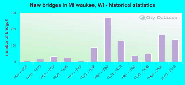
- New bridges - historical statistics
- 1Before 1900
- 61900-1909
- 161910-1919
- 331920-1929
- 271930-1939
- 51940-1949
- 891950-1959
- 2731960-1969
- 1301970-1979
- 371980-1989
- 511990-1999
- 1682000-2009
- 1382010-2019
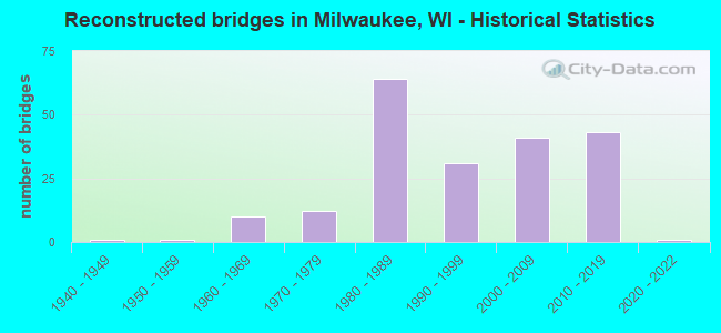
- Reconstructed bridges - Historical Statistics
- 11940-1949
- 11950-1959
- 101960-1969
- 121970-1979
- 641980-1989
- 311990-1999
- 412000-2009
- 432010-2019
- 12020-2022
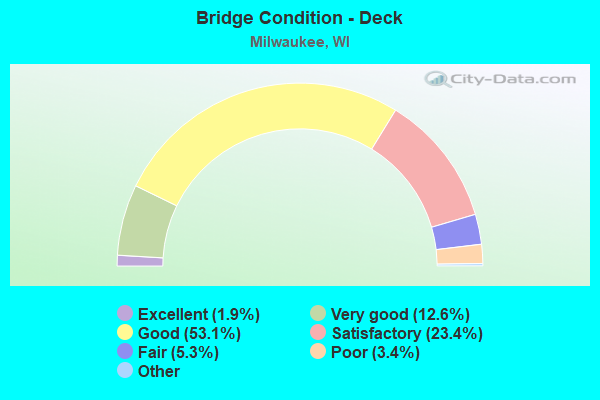
- Bridge Condition - Deck
- 1.9%Excellent
- 12.6%Very good
- 53.1%Good
- 23.4%Satisfactory
- 5.3%Fair
- 3.4%Poor
- 0.4%Serious
- 0.2%Failed
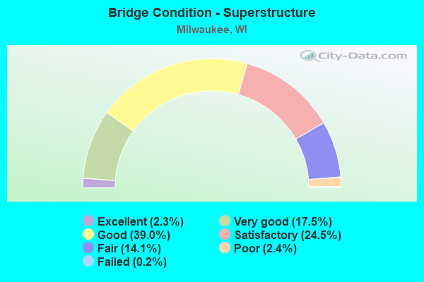
- Bridge Condition - Superstructure
- 2.3%Excellent
- 17.5%Very good
- 39.0%Good
- 24.5%Satisfactory
- 14.1%Fair
- 2.4%Poor
- 0.2%Failed
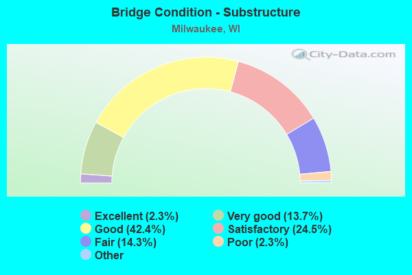
- Bridge Condition - Substructure
- 2.3%Excellent
- 13.7%Very good
- 42.4%Good
- 24.5%Satisfactory
- 14.3%Fair
- 2.3%Poor
- 0.6%Serious
- 0.2%Critical
- 0.2%Failed
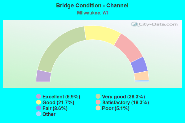
- Bridge Condition - Channel
- 6.9%Excellent
- 38.3%Very good
- 21.7%Good
- 18.3%Satisfactory
- 8.6%Fair
- 5.1%Poor
- 1.1%Serious
- 0.6%Failed
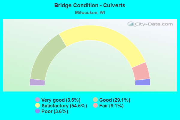
- Bridge Condition - Culverts
- 3.6%Very good
- 29.1%Good
- 54.5%Satisfactory
- 9.1%Fair
- 3.6%Poor
Find on map >> Show street view
Structure Number: B400668, Location: AT RAMP (Lat: 42.947253, Lng: -87.908378), Route carried "under" structure: Ramp Other road , Year Built: 2001, Structure Length: 0. m, Average Daily Traffic: 500 (year 2018), Features Intersected: HOWELL TERMINAL ROAD, Facility Carried by Structure: OFF RAMP - AIRPORT
Minimum Vertical Clearance: 4.72m (15.49ft), Kilometerpoint: 0.000, Lanes on structure: 1, Lanes under structure: 1, Material/Design: Prestressed concrete, Design/Construction: Stringer/Multi-beam, Length of Maximum Span: 14.9m (48.9ft)
Find on map >> Show street view
Structure Number: B4006830001, Location: 0.25M N MARQUETTE INER. (Lat: 43.038597, Lng: -87.925250), Route carried "under" structure: Interstate 43, Year Built: 2006, Structure Length: 0. m, Average Daily Traffic: 189,000 (year 2019), Features Intersected: IH43, Facility Carried by Structure: LRD WISCONSIN AVE
Minimum Vertical Clearance: 5.12m (16.80ft), Kilometerpoint: 0.000, Lanes on structure: 7, Lanes under structure: 11, Material/Design: Prestressed concrete continuous, Design/Construction: Stringer/Multi-beam, Length of Maximum Span: 21.9m (71.9ft)
Find on map >> Show street view
Structure Number: B4006830002, Location: 0.25M N MARQUETTE INTER. (Lat: 43.039742, Lng: -87.925425), Route carried "under" structure: Ramp Interstate 43, Year Built: 2006, Structure Length: 0. m, Average Daily Traffic: 33,400 (year 2019), Features Intersected: IH RAMP IH43 SB-IH94WB, Facility Carried by Structure: LRD 11TH STREET
Minimum Vertical Clearance: 6.16m (20.21ft), Kilometerpoint: 0.000, Lanes on structure: 4, Lanes under structure: 2, Material/Design: Prestressed concrete, Design/Construction: Stringer/Multi-beam, Length of Maximum Span: 17.4m (57.1ft)
Find on map >> Show street view
Structure Number: B400684, Location: 0.4M N JCT IH 94 TO W (Lat: 43.040197, Lng: -87.925433), Route carried "under" structure: Interstate 43, Year Built: 2005, Structure Length: 0. m, Average Daily Traffic: 160,000 (year 2018), Features Intersected: IH 43, Facility Carried by Structure: USH 18 - WELLS ST
Minimum Vertical Clearance: 4.98m (16.34ft), Kilometerpoint: 0.000, Lanes on structure: 3, Lanes under structure: 10, Material/Design: Prestressed concrete continuous, Design/Construction: Stringer/Multi-beam, Length of Maximum Span: 32.8m (107.6ft)
Find on map >> Show street view
Structure Number: B400685, Location: AT STATE ST (Lat: 43.043297, Lng: -87.924933), Route carried "under" structure: Interstate 43, Year Built: 2005, Structure Length: 0. m, Average Daily Traffic: 160,000 (year 2018), Features Intersected: IH 43, Facility Carried by Structure: USH 18 WB (STATE S
Minimum Vertical Clearance: 4.90m (16.08ft), Kilometerpoint: 0.000, Lanes on structure: 4, Lanes under structure: 10, Material/Design: Prestressed concrete, Design/Construction: Stringer/Multi-beam, Length of Maximum Span: 32.0m (105.0ft)
Find on map >> Show street view
Structure Number: B400686, Location: ATHIGHLAND AVENUE (Lat: 43.044367, Lng: -87.926406), Route carried "under" structure: Interstate 43, Year Built: 2006, Structure Length: 0. m, Average Daily Traffic: 160,000 (year 2018), Features Intersected: IH 43, Facility Carried by Structure: LRD HIGHLAND AVENU
Minimum Vertical Clearance: 5.03m (16.50ft), Kilometerpoint: 0.000, Lanes on structure: 4, Lanes under structure: 9, Material/Design: Prestressed concrete, Design/Construction: Stringer/Multi-beam, Length of Maximum Span: 37.6m (123.4ft)
Find on map >> Show street view
Structure Number: B400687, Location: I43 SB (Lat: 43.048292, Lng: -87.926706), Route carried "under" structure: Ramp State highway 145, Year Built: 2006, Structure Length: 0. m, Average Daily Traffic: 15,900 (year 2019), Truck Traffic: 11%, Features Intersected: STH 145 TO I43 SB ENTRAN, Facility Carried by Structure: IH I43 SB TO HIGHL
Minimum Vertical Clearance: 4.98m (16.34ft), Kilometerpoint: 0.000, Lanes on structure: 1, Lanes under structure: 2, Material/Design: Steel continuous, Design/Construction: Stringer/Multi-beam, Length of Maximum Span: 39.1m (128.3ft)
Find on map >> Show street view
Structure Number: B400688, Location: I 43 NB (Lat: 43.047333, Lng: -87.925797), Route carried "under" structure: Ramp Interstate 43, Year Built: 2006, Structure Length: 0. m, Average Daily Traffic: 9,900 (year 2019), Truck Traffic: 11%, Features Intersected: IH RAMP IH 43 NB - STH 1, Facility Carried by Structure: IH RAMP HIGHLAND A
Minimum Vertical Clearance: 5.07m (16.63ft), Kilometerpoint: 0.000, Lanes on structure: 2, Lanes under structure: 1, Material/Design: Steel continuous, Design/Construction: Stringer/Multi-beam, Length of Maximum Span: 40.2m (131.9ft)
Find on map >> Show street view
Structure Number: B400689, Location: AT WINNEBAGO ST (Lat: 43.048553, Lng: -87.926989), Route carried "under" structure: Interstate 43, Year Built: 2006, Structure Length: 0. m, Average Daily Traffic: 155,100 (year 2019), Features Intersected: IH 43, Facility Carried by Structure: LRD WINNEBAGO ST
Minimum Vertical Clearance: 5.05m (16.57ft), Kilometerpoint: 0.000, Lanes on structure: 4, Lanes under structure: 14, Material/Design: Prestressed concrete, Design/Construction: Stringer/Multi-beam, Length of Maximum Span: 36.8m (120.7ft)
Find on map >> Show street view
Structure Number: B40069, Location: AT 43 (Lat: 43.049317, Lng: -87.925728), Route carried "under" structure: State highway 145, Year Built: 2006, Structure Length: 0. m, Average Daily Traffic: 20,000 (year 2019), Truck Traffic: 11%, Features Intersected: STH 145, Facility Carried by Structure: IH 43 NB
Minimum Vertical Clearance: 5.58m (18.31ft), Kilometerpoint: 0.000, Lanes on structure: 4, Lanes under structure: 8, Material/Design: Prestressed concrete continuous, Design/Construction: Stringer/Multi-beam, Length of Maximum Span: 34.3m (112.5ft)
Find on map >> Show street view
Structure Number: B400691, Location: AT IH 43 (Lat: 43.050364, Lng: -87.926061), Route carried "under" structure: State highway 145, Year Built: 2005, Structure Length: 0. m, Average Daily Traffic: 20,000 (year 2019), Truck Traffic: 11%, Features Intersected: STH 145, Facility Carried by Structure: IH-43 SB
Minimum Vertical Clearance: 5.18m (16.99ft), Kilometerpoint: 0.000, Lanes on structure: 4, Lanes under structure: 8, Material/Design: Prestressed concrete, Design/Construction: Stringer/Multi-beam, Length of Maximum Span: 34.3m (112.5ft)
Find on map >> Show street view
Structure Number: B400692, Location: AT WALNUT ST (Lat: 43.052514, Lng: -87.925883), Route carried "under" structure: Interstate 43, Year Built: 2006, Structure Length: 0. m, Average Daily Traffic: 168,000 (year 2019), Features Intersected: IH 43, Facility Carried by Structure: LRD WALNUT ST
Minimum Vertical Clearance: 5.16m (16.93ft), Kilometerpoint: 0.000, Lanes on structure: 4, Lanes under structure: 10, Material/Design: Prestressed concrete continuous, Design/Construction: Stringer/Multi-beam, Length of Maximum Span: 40.8m (133.9ft)
Find on map >> Show street view
Structure Number: B400715, Location: AT BRADY ST (Lat: 43.051494, Lng: -87.889167), Route carried "under" structure: City street , Year Built: 2005, Structure Length: 0. m, Average Daily Traffic: 29,800 (year 2019), Features Intersected: LRD LINCOLN MEMORIAL DR, Facility Carried by Structure: BRADY ST PEDESTRIA
Minimum Vertical Clearance: 4.63m (15.19ft), Kilometerpoint: 0.000, Lanes under structure: 2, Material/Design: Prestressed concrete continuous, Design/Construction: Stringer/Multi-beam, Length of Maximum Span: 38.1m (125.0ft)
Find on map >> Show street view
Structure Number: B400725, Location: AT INTERSECTION (Lat: 43.057889, Lng: -87.897903), Route carried "under" structure: City street , Year Built: 2010, Structure Length: 0. m, Average Daily Traffic: 500 (year 2020), Truck Traffic: 1%, Features Intersected: LRD N RIVERBOAT RD, Facility Carried by Structure: LRD N HUMBOLDT AVE
Minimum Vertical Clearance: 4.50m (14.76ft), Kilometerpoint: 0.000, Lanes on structure: 2, Lanes under structure: 2, Material/Design: Concrete, Design/Construction: Slab, Length of Maximum Span: 16.9m (55.4ft)
Find on map >> Show street view
Structure Number: B400727, Location: AT KK RIVER TRAIL (Lat: 42.996333, Lng: -87.912567), Route carried "under" structure: State highway 38, Year Built: 2012, Structure Length: 0. m, Average Daily Traffic: 15,412 (year 2019), Features Intersected: STH 38/CHASE AVE, Facility Carried by Structure: KK RIVER TRAIL
Minimum Vertical Clearance: 5.27m (17.29ft), Kilometerpoint: 0.000, Lanes under structure: 4, Material/Design: Prestressed concrete continuous, Design/Construction: Stringer/Multi-beam, Length of Maximum Span: 27.4m (89.9ft)
Find on map >> Show street view
Structure Number: B400747, Location: AT HANK AARON TRAIL (Lat: 43.024144, Lng: -87.986664), Route carried "under" structure: City street , Year Built: 2013, Structure Length: 0. m, Average Daily Traffic: 25,100 (year 2019), Truck Traffic: 4%, Features Intersected: LRD HAWLEY RD, Facility Carried by Structure: HANK AARON STATE T
Minimum Vertical Clearance: 5.24m (17.19ft), Kilometerpoint: 0.000, Lanes under structure: 4, Material/Design: Steel, Design/Construction: Truss - Deck, Length of Maximum Span: 30.4m (99.7ft)
Find on map >> Show street view
Structure Number: B400766, Location: 0.3M E JCT STH 145 (Lat: 43.119714, Lng: -88.005803), Route carried "under" structure: City street , Year Built: 2017, Structure Length: 0. m, Average Daily Traffic: 26,600 (year 2019), Features Intersected: LRD W SILVER SPRING DRIV, Facility Carried by Structure: STH 181-N 76TH ST
Minimum Vertical Clearance: 5.08m (16.67ft), Kilometerpoint: 0.000, Lanes on structure: 6, Lanes under structure: 4, Material/Design: Steel, Design/Construction: Stringer/Multi-beam, Length of Maximum Span: 17.7m (58.1ft)
Find on map >> Show street view
Structure Number: B400768, Location: 1.0 M EAST OF USH41 (Lat: 42.929767, Lng: -87.901314), Route carried "under" structure: County highway , Year Built: 2012, Structure Length: 0. m, Average Daily Traffic: 18,700 (year 2018), Features Intersected: CTH ZZ, Facility Carried by Structure: LRD PERIMETER ROAD
Minimum Vertical Clearance: 4.63m (15.19ft), Kilometerpoint: 0.000, Lanes on structure: 2, Lanes under structure: 4, Material/Design: Prestressed concrete, Design/Construction: Stringer/Multi-beam, Length of Maximum Span: 28.7m (94.2ft)
Find on map >> Show street view
Structure Number: B400772, Location: 0.6 MI NORTH STH38 (Lat: 42.938636, Lng: -87.909936), Route carried "under" structure: State highway 38, Year Built: 2013, Structure Length: 0. m, Average Daily Traffic: 23,600 (year 2019), Features Intersected: STH 38/HOWELL AVE, Facility Carried by Structure: LRD (GMIA) AIRPORT
Minimum Vertical Clearance: 5.18m (16.99ft), Kilometerpoint: 0.000, Lanes on structure: 2, Lanes under structure: 4, Material/Design: Prestressed concrete, Design/Construction: Stringer/Multi-beam, Length of Maximum Span: 36.0m (118.1ft)
Find on map >> Show street view
Structure Number: B400785, Location: 0.6M E JCT STH 181 TO N (Lat: 43.027972, Lng: -88.007114), Route carried "under" structure: Interstate 94, Year Built: 2014, Structure Length: 0. m, Average Daily Traffic: 168,000 (year 2019), Features Intersected: IH 94, Facility Carried by Structure: LRD S 76TH ST
Minimum Vertical Clearance: 5.18m (16.99ft), Kilometerpoint: 0.000, Lanes on structure: 4, Lanes under structure: 10, Material/Design: Prestressed concrete, Design/Construction: Stringer/Multi-beam, Length of Maximum Span: 32.3m (106.0ft)
Find on map >> Show street view
Structure Number: B400787, Location: ZOO INTERCHANGE (Lat: 43.027200, Lng: -88.043522), Route carried "under" structure: City street , Year Built: 2016, Structure Length: 0. m, Average Daily Traffic: 4,200 (year 2019), Features Intersected: LRD RAMP, STH 100 - IH 9, Facility Carried by Structure: IH RAMP, IH 94 EB
Minimum Vertical Clearance: 5.18m (16.99ft), Kilometerpoint: 0.000, Lanes on structure: 3, Lanes under structure: 1, Material/Design: Steel continuous, Design/Construction: Stringer/Multi-beam, Length of Maximum Span: 52.4m (171.9ft)
Find on map >> Show street view
Structure Number: B400791, Location: AT USH 45 NB (Lat: 43.026936, Lng: -88.035119), Route carried "under" structure: Interstate 94, Year Built: 2015, Structure Length: 0. m, Average Daily Traffic: 84,400 (year 2019), Features Intersected: IH 94 EB, Facility Carried by Structure: IH 41/USH 45 NB
Minimum Vertical Clearance: 5.39m (17.68ft), Kilometerpoint: 0.000, Lanes on structure: 4, Lanes under structure: 6, Material/Design: Prestressed concrete, Design/Construction: Stringer/Multi-beam, Length of Maximum Span: 41.5m (136.2ft)
Find on map >> Show street view
Structure Number: B40081, Location: 3.1M W JCT STH 100 (Lat: 42.916197, Lng: -87.936075), Route carried "under" structure: Interstate 41, Year Built: 2013, Structure Length: 0. m, Average Daily Traffic: 121,000 (year 2018), Features Intersected: IH 41/94, Facility Carried by Structure: LRD RAWSON AVE (CT
Minimum Vertical Clearance: 5.15m (16.90ft), Kilometerpoint: 0.000, Lanes on structure: 8, Lanes under structure: 8, Material/Design: Prestressed concrete continuous, Design/Construction: Stringer/Multi-beam, Length of Maximum Span: 30.0m (98.4ft)
Find on map >> Show street view
Structure Number: B400811, Location: AT COLLEGE AVE (Lat: 42.930164, Lng: -87.935678), Route carried "under" structure: Interstate 41, Year Built: 2009, Structure Length: 0. m, Average Daily Traffic: 169,000 (year 2019), Features Intersected: IH 41/94, Facility Carried by Structure: LRD COLLEGE AVENUE
Minimum Vertical Clearance: 5.39m (17.68ft), Kilometerpoint: 0.000, Lanes on structure: 8, Lanes under structure: 10, Material/Design: Prestressed concrete, Design/Construction: Stringer/Multi-beam, Length of Maximum Span: 29.6m (97.1ft)
Find on map >> Show street view
Structure Number: B400812, Location: AT 94WB (Lat: 42.937383, Lng: -87.934761), Route carried "under" structure: City street , Year Built: 2010, Structure Length: 0. m, Average Daily Traffic: 1,900 (year 2019), Features Intersected: LRD RAMSEY AVE, Facility Carried by Structure: IH 41 NB/94 WB
Minimum Vertical Clearance: 5.31m (17.42ft), Kilometerpoint: 0.000, Lanes on structure: 6, Lanes under structure: 2, Material/Design: Concrete continuous, Design/Construction: Slab, Length of Maximum Span: 19.8m (65.0ft)
Find on map >> Show street view
Structure Number: B400813, Location: AT INTERSECTION (Lat: 42.937925, Lng: -87.935639), Route carried "under" structure: City street , Year Built: 2010, Structure Length: 0. m, Average Daily Traffic: 1,900 (year 2019), Features Intersected: LRD RAMSEY AVE, Facility Carried by Structure: IH 41 SB/IH 94 EB
Minimum Vertical Clearance: 4.71m (15.45ft), Kilometerpoint: 0.000, Lanes on structure: 6, Lanes under structure: 2, Material/Design: Concrete continuous, Design/Construction: Slab, Length of Maximum Span: 19.8m (65.0ft)
Find on map >> Show street view
Structure Number: B400814, Location: 0.9M E GRANGE AVE (Lat: 42.940217, Lng: -87.935650), Route carried "under" structure: Interstate 41, Year Built: 2010, Structure Length: 0. m, Average Daily Traffic: 143,000 (year 2019), Truck Traffic: 5%, Features Intersected: IH 41/94, Facility Carried by Structure: STH 119 EB AIRPORT
Minimum Vertical Clearance: 5.11m (16.77ft), Kilometerpoint: 0.000, Lanes on structure: 1, Lanes under structure: 11, Material/Design: Prestressed concrete continuous, Design/Construction: Stringer/Multi-beam, Length of Maximum Span: 42.7m (140.1ft)
Find on map >> Show street view
Structure Number: B400815, Location: 1.3 MI S JCT LAYTON AVE (Lat: 42.940525, Lng: -87.934708), Route carried "under" structure: Interstate 41, Year Built: 2009, Structure Length: 0. m, Average Daily Traffic: 143,000 (year 2019), Features Intersected: IH 41/IH 94, Facility Carried by Structure: STH 119 WB - AIRPO
Minimum Vertical Clearance: 5.35m (17.55ft), Kilometerpoint: 0.000, Lanes on structure: 1, Lanes under structure: 11, Material/Design: Prestressed concrete, Design/Construction: Stringer/Multi-beam, Length of Maximum Span: 42.7m (140.1ft)
Find on map >> Show street view
Structure Number: B400816, Location: AT GRANGE AVE (Lat: 42.944694, Lng: -87.935544), Route carried "under" structure: Interstate 41, Year Built: 2009, Structure Length: 0. m, Average Daily Traffic: 183,000 (year 2019), Features Intersected: IH 41/94, Facility Carried by Structure: LRD GRANGE AVENUE
Minimum Vertical Clearance: 4.62m (15.16ft), Kilometerpoint: 0.000, Lanes on structure: 2, Lanes under structure: 13, Material/Design: Steel, Design/Construction: Stringer/Multi-beam, Length of Maximum Span: 42.3m (138.8ft)
Find on map >> Show street view
Structure Number: B400817, Location: AT GRANGE AV (Lat: 42.944953, Lng: -87.934544), Route carried "under" structure: Interstate 41, Year Built: 2009, Structure Length: 0. m, Average Daily Traffic: 183,000 (year 2019), Features Intersected: IH 41/94, Facility Carried by Structure: LRD GRANGE AVE WB
Minimum Vertical Clearance: 4.85m (15.91ft), Kilometerpoint: 0.000, Lanes on structure: 2, Lanes under structure: 13, Material/Design: Steel continuous, Design/Construction: Stringer/Multi-beam, Length of Maximum Span: 41.9m (137.5ft)
Find on map >> Show street view
Structure Number: B400818, Location: AT INTERSECTION (Lat: 42.951881, Lng: -87.934372), Route carried "under" structure: City street , Year Built: 2011, Structure Length: 0. m, Average Daily Traffic: 3,900 (year 2019), Truck Traffic: 9%, Features Intersected: LRD EDGERTON AVE, Facility Carried by Structure: IH 41 NB/94 WB
Minimum Vertical Clearance: 5.43m (17.81ft), Kilometerpoint: 0.000, Lanes on structure: 6, Lanes under structure: 2, Material/Design: Concrete continuous, Design/Construction: Slab, Length of Maximum Span: 19.8m (65.0ft)
Find on map >> Show street view
Structure Number: B400819, Location: AT INTERSECTION (Lat: 42.952253, Lng: -87.935394), Route carried "under" structure: City street , Year Built: 2011, Structure Length: 0. m, Average Daily Traffic: 3,900 (year 2019), Features Intersected: LRD EDGERTON AVE, Facility Carried by Structure: IH 41 SB/94 EB
Minimum Vertical Clearance: 4.68m (15.35ft), Kilometerpoint: 0.000, Lanes on structure: 7, Lanes under structure: 2, Material/Design: Concrete continuous, Design/Construction: Slab, Length of Maximum Span: 19.8m (65.0ft)
Find on map >> Show street view
Structure Number: B40082, Location: 0.7M E JCT STH 241 (Lat: 42.959208, Lng: -87.935328), Route carried "under" structure: Interstate 41, Year Built: 2010, Structure Length: 0. m, Average Daily Traffic: 183,000 (year 2019), Truck Traffic: 10%, Features Intersected: IH 41/94, Facility Carried by Structure: LRD LAYTON AVENUE
Minimum Vertical Clearance: 5.05m (16.57ft), Kilometerpoint: 0.000, Lanes on structure: 4, Lanes under structure: 12, Material/Design: Steel continuous, Design/Construction: Box Beam or Girders - Multiple, Length of Maximum Span: 47.2m (154.9ft)
Find on map >> Show street view
Structure Number: B400821, Location: MITCHELL INTERCHANGE (Lat: 42.961900, Lng: -87.935558), Route carried "under" structure: Ramp Interstate 94, Year Built: 2012, Structure Length: 0. m, Average Daily Traffic: 46,600 (year 2019), Features Intersected: IH RAMP SW IH41/94 NB TO
Minimum Vertical Clearance: 5.13m (16.83ft), Kilometerpoint: 0.000, Lanes on structure: 7, Lanes under structure: 3, Material/Design: Prestressed concrete, Design/Construction: Stringer/Multi-beam, Length of Maximum Span: 16.8m (55.1ft)
Find on map >> Show street view
Structure Number: B400823, Location: .5M S OF 894&94XING (Lat: 42.960978, Lng: -87.935072), Route carried "under" structure: Interstate 41, Year Built: 2012, Structure Length: 0. m, Average Daily Traffic: 46,500 (year 2019), Features Intersected: IH 41 SB, Facility Carried by Structure: IH RAMP IH 43 SB/9
Minimum Vertical Clearance: 5.13m (16.83ft), Kilometerpoint: 0.000, Lanes on structure: 2, Lanes under structure: 3, Material/Design: Steel, Design/Construction: Stringer/Multi-beam, Length of Maximum Span: 68.6m (225.1ft)
Find on map >> Show street view
Structure Number: B400824, Location: .2M SOUTH OF 894 XING (Lat: 42.961169, Lng: -87.935247), Route carried "under" structure: Interstate 41, Year Built: 2012, Structure Length: 0. m, Average Daily Traffic: 46,500 (year 2019), Features Intersected: IH 41 SB, Facility Carried by Structure: IH RAMP IH 43 SB/9
Minimum Vertical Clearance: 7.67m (25.16ft), Kilometerpoint: 0.000, Lanes on structure: 1, Lanes under structure: 3, Material/Design: Prestressed concrete, Design/Construction: Stringer/Multi-beam, Length of Maximum Span: 46.2m (151.6ft)
Find on map >> Show street view
Structure Number: B400827, Location: MITCHELL INTERCHANGE (Lat: 42.962467, Lng: -87.935119), Route carried "under" structure: Interstate 43, Year Built: 2011, Structure Length: 0. m, Average Daily Traffic: 27,400 (year 2019), Features Intersected: IH 43 NB, Facility Carried by Structure: IH 94 EB/WB
Minimum Vertical Clearance: 5.11m (16.77ft), Kilometerpoint: 0.000, Lanes on structure: 9, Lanes under structure: 2, Material/Design: Prestressed concrete, Design/Construction: Stringer/Multi-beam, Length of Maximum Span: 18.4m (60.4ft)
Find on map >> Show street view
Structure Number: B400828, Location: AT 94WB (Lat: 42.965689, Lng: -87.929350), Route carried "under" structure: City street , Year Built: 2010, Structure Length: 0. m, Average Daily Traffic: 13,100 (year 2019), Truck Traffic: 5%, Features Intersected: LRD S13TH ST, Facility Carried by Structure: IH 43 NB/94 WB
Minimum Vertical Clearance: 5.53m (18.14ft), Kilometerpoint: 0.000, Lanes on structure: 5, Lanes under structure: 4, Material/Design: Prestressed concrete continuous, Design/Construction: Stringer/Multi-beam, Length of Maximum Span: 40.5m (132.9ft)
Find on map >> Show street view
Structure Number: B400829, Location: AT 94 (Lat: 42.966408, Lng: -87.926869), Route carried "under" structure: City street , Year Built: 2012, Structure Length: 0. m, Average Daily Traffic: 13,100 (year 2019), Features Intersected: LRD S 13TH ST, Facility Carried by Structure: IH 43 SB/IH 94 EB
Minimum Vertical Clearance: 5.96m (19.55ft), Kilometerpoint: 0.000, Lanes on structure: 5, Lanes under structure: 4, Material/Design: Prestressed concrete, Design/Construction: Stringer/Multi-beam, Length of Maximum Span: 40.5m (132.9ft)
Find on map >> Show street view
Structure Number: B40083, Location: 4.5 MI S JCT STH 59 (Lat: 42.966544, Lng: -87.919597), Route carried "under" structure: City street , Year Built: 2010, Structure Length: 0. m, Average Daily Traffic: 13,900 (year 2019), Truck Traffic: 11%, Features Intersected: LRD S 6TH ST, Facility Carried by Structure: IH-43 NB/IH-94 WB
Minimum Vertical Clearance: 4.67m (15.32ft), Kilometerpoint: 0.000, Lanes on structure: 5, Lanes under structure: 2, Material/Design: Prestressed concrete, Design/Construction: Stringer/Multi-beam, Length of Maximum Span: 35.0m (114.8ft)
Find on map >> Show street view
Structure Number: B400831, Location: AT 94 (Lat: 42.967147, Lng: -87.919175), Route carried "under" structure: City street , Year Built: 2012, Structure Length: 0. m, Average Daily Traffic: 13,900 (year 2019), Features Intersected: LRD S 6TH ST, Facility Carried by Structure: IH 43 SB/IH 94 EB
Minimum Vertical Clearance: 4.72m (15.49ft), Kilometerpoint: 0.000, Lanes on structure: 5, Lanes under structure: 2, Material/Design: Concrete, Design/Construction: Stringer/Multi-beam, Length of Maximum Span: 35.2m (115.5ft)
Find on map >> Show street view
Structure Number: B400832, Location: AT INTERSECTION (Lat: 42.961983, Lng: -87.937953), Route carried "under" structure: Interstate 43, Year Built: 2011, Structure Length: 0. m, Average Daily Traffic: 27,400 (year 2019), Features Intersected: IH 43 NB, Facility Carried by Structure: IH 41
Minimum Vertical Clearance: 5.11m (16.77ft), Kilometerpoint: 0.000, Lanes on structure: 6, Lanes under structure: 2, Material/Design: Prestressed concrete, Design/Construction: Stringer/Multi-beam, Length of Maximum Span: 16.8m (55.1ft)
Find on map >> Show street view
Structure Number: B400833, Location: AT S20TH ST (Lat: 42.961964, Lng: -87.938761), Route carried "under" structure: Interstate 41, Year Built: 2011, Structure Length: 0. m, Average Daily Traffic: 145,000 (year 2019), Truck Traffic: 5%, Features Intersected: IH 41/43/894, Facility Carried by Structure: LRD S 20TH ST
Minimum Vertical Clearance: 5.16m (16.93ft), Kilometerpoint: 0.000, Lanes on structure: 4, Lanes under structure: 11, Material/Design: Prestressed concrete continuous, Design/Construction: Stringer/Multi-beam, Length of Maximum Span: 29.0m (95.1ft)
Find on map >> Show street view
Structure Number: B400834, Location: 0.1 MI E JCT STH 241 (Lat: 42.962272, Lng: -87.946225), Route carried "under" structure: Interstate 41, Year Built: 2011, Structure Length: 0. m, Average Daily Traffic: 153,000 (year 2019), Features Intersected: IH 41/43/894
Minimum Vertical Clearance: 5.23m (17.16ft), Kilometerpoint: 0.000, Lanes on structure: 2, Lanes under structure: 11, Material/Design: Steel, Design/Construction: Box Beam or Girders - Multiple, Length of Maximum Span: 35.5m (116.5ft)
Find on map >> Show street view
Structure Number: B400835, Location: AT 241XING (Lat: 42.963253, Lng: -87.948911), Route carried "under" structure: Interstate 41, Year Built: 2009, Structure Length: 0. m, Average Daily Traffic: 153,000 (year 2019), Features Intersected: IH 41/43/894
Minimum Vertical Clearance: 5.26m (17.26ft), Kilometerpoint: 0.000, Lanes on structure: 3, Lanes under structure: 11, Material/Design: Prestressed concrete continuous, Design/Construction: Stringer/Multi-beam, Length of Maximum Span: 31.8m (104.3ft)
Find on map >> Show street view
Structure Number: B400836, Location: 4.1 MI N JCT STH 100 (Lat: 42.962267, Lng: -87.948414), Route carried "under" structure: Interstate 41, Year Built: 2009, Structure Length: 0. m, Average Daily Traffic: 153,000 (year 2019), Features Intersected: IH 41/43/894
Minimum Vertical Clearance: 4.81m (15.78ft), Kilometerpoint: 0.000, Lanes on structure: 3, Lanes under structure: 11, Material/Design: Prestressed concrete continuous, Design/Construction: Stringer/Multi-beam, Length of Maximum Span: 31.7m (104.0ft)
Find on map >> Show street view
Structure Number: B400837, Location: 0.1 MI W JCT STH 241 (Lat: 42.963058, Lng: -87.951711), Route carried "under" structure: Interstate 41, Year Built: 2011, Structure Length: 0. m, Average Daily Traffic: 153,000 (year 2019), Truck Traffic: 8%, Features Intersected: IH 41/43/894
Minimum Vertical Clearance: 5.23m (17.16ft), Kilometerpoint: 0.000, Lanes on structure: 1, Lanes under structure: 9, Material/Design: Steel, Design/Construction: Box Beam or Girders - Multiple, Length of Maximum Span: 30.5m (100.1ft)
Find on map >> Show street view
Structure Number: B400838, Location: AT STH119 (Lat: 42.940700, Lng: -87.930936), Route carried "under" structure: City street , Year Built: 2012, Structure Length: 0. m, Average Daily Traffic: 500 (year 2019), Features Intersected: LRD S 14TH ST, Facility Carried by Structure: STH 119 EB-AIRPORT
Minimum Vertical Clearance: 4.82m (15.81ft), Kilometerpoint: 0.000, Lanes on structure: 2, Lanes under structure: 2, Material/Design: Concrete continuous, Design/Construction: Slab, Length of Maximum Span: 13.1m (43.0ft)
Find on map >> Show street view
Structure Number: B400839, Location: .3M E GRANGE AVE (Lat: 42.941075, Lng: -87.930511), Route carried "under" structure: City street , Year Built: 2012, Structure Length: 0. m, Average Daily Traffic: 500 (year 2019), Features Intersected: LRD S 14TH ST, Facility Carried by Structure: STH 119 WB/AIRPORT
Minimum Vertical Clearance: 5.05m (16.57ft), Kilometerpoint: 0.000, Lanes on structure: 2, Lanes under structure: 2, Material/Design: Concrete continuous, Design/Construction: Slab, Length of Maximum Span: 16.5m (54.1ft)
Find on map >> Show street view
Structure Number: B40084, Location: AT STH119 (Lat: 42.940892, Lng: -87.929653), Route carried "under" structure: City street , Year Built: 2012, Structure Length: 0. m, Average Daily Traffic: 10,900 (year 2019), Features Intersected: LRD S 13TH ST, Facility Carried by Structure: STH 119 EB-AIRPORT
Minimum Vertical Clearance: 4.73m (15.52ft), Kilometerpoint: 0.000, Lanes on structure: 2, Lanes under structure: 4, Material/Design: Prestressed concrete, Design/Construction: Stringer/Multi-beam, Length of Maximum Span: 29.3m (96.1ft)
Find on map >> Show street view
Structure Number: B400841, Location: .1M S HOWELL ST (Lat: 42.941206, Lng: -87.929286), Route carried "under" structure: City street , Year Built: 2012, Structure Length: 0. m, Average Daily Traffic: 10,900 (year 2019), Features Intersected: LRD S 13TH ST, Facility Carried by Structure: STH 119 WB/AIRPORT
Minimum Vertical Clearance: 4.88m (16.01ft), Kilometerpoint: 0.000, Lanes on structure: 2, Lanes under structure: 4, Material/Design: Prestressed concrete, Design/Construction: Stringer/Multi-beam, Length of Maximum Span: 29.3m (96.1ft)
Find on map >> Show street view
Structure Number: B400844, Location: .4M E GRANGE AVE (Lat: 42.944064, Lng: -87.919744), Route carried "under" structure: City street , Year Built: 2012, Structure Length: 0. m, Average Daily Traffic: 3,200 (year 2019), Features Intersected: LRD S 6TH ST, Facility Carried by Structure: STH 119 EB-AIRPORT
Minimum Vertical Clearance: 4.88m (16.01ft), Kilometerpoint: 0.000, Lanes on structure: 2, Lanes under structure: 2, Material/Design: Prestressed concrete, Design/Construction: Stringer/Multi-beam, Length of Maximum Span: 27.4m (89.9ft)
Find on map >> Show street view
Structure Number: B400845, Location: AT STH119 (Lat: 42.944486, Lng: -87.919450), Route carried "under" structure: City street , Year Built: 2012, Structure Length: 0. m, Average Daily Traffic: 3,200 (year 2019), Features Intersected: LRD S 6TH ST, Facility Carried by Structure: STH 119 WB-AIRPORT
Minimum Vertical Clearance: 4.97m (16.31ft), Kilometerpoint: 0.000, Lanes on structure: 2, Lanes under structure: 2, Material/Design: Prestressed concrete, Design/Construction: Stringer/Multi-beam, Length of Maximum Span: 27.4m (89.9ft)
Find on map >> Show street view
Structure Number: B400849, Location: 1 M W JCT STH 181 (Lat: 43.023669, Lng: -88.035769), Route carried "under" structure: City street , Year Built: 2015, Structure Length: 0. m, Average Daily Traffic: 3,200 (year 2019), Features Intersected: LRD W SCHLINGER AVE, Facility Carried by Structure: IH RAMP, IH 41 NB/
Minimum Vertical Clearance: 6.74m (22.11ft), Kilometerpoint: 0.000, Lanes on structure: 3, Lanes under structure: 2, Material/Design: Prestressed concrete, Design/Construction: Stringer/Multi-beam, Length of Maximum Span: 24.4m (80.1ft)
Find on map >> Show street view
Structure Number: B40085, Location: LOCATION UNKNOWN, PLEASE (Lat: 43.028586, Lng: -88.031133), Route carried "under" structure: Ramp Interstate 94, Year Built: 2017, Structure Length: 0. m, Average Daily Traffic: 2,600 (year 2019), Features Intersected: IH RAMP, 84TH ST - IH 94
Minimum Vertical Clearance: 5.08m (16.67ft), Kilometerpoint: 0.000, Lanes on structure: 2, Lanes under structure: 1, Material/Design: Prestressed concrete, Design/Construction: Stringer/Multi-beam, Length of Maximum Span: 14.7m (48.2ft)
Find on map >> Show street view
Structure Number: B400851, Location: .1M E OF USH 45 (Lat: 43.027147, Lng: -88.032778), Route carried "under" structure: Ramp Interstate 94, Year Built: 2017, Structure Length: 0. m, Average Daily Traffic: 4,500 (year 2019), Features Intersected: IH RAMP, IH 94 EB - S 84, Facility Carried by Structure: IH RAMP, IH 41/USH
Minimum Vertical Clearance: 5.09m (16.70ft), Kilometerpoint: 0.000, Lanes on structure: 1, Lanes under structure: 1, Material/Design: Prestressed concrete continuous, Design/Construction: Stringer/Multi-beam, Length of Maximum Span: 42.4m (139.1ft)
Find on map >> Show street view
Structure Number: B400852, Location: AT STH 100 (Lat: 43.027422, Lng: -88.039553), Route carried "under" structure: Ramp Interstate 94, Year Built: 2015, Structure Length: 0. m, Average Daily Traffic: 6,700 (year 2019), Features Intersected: IH RAMP, IH 94 WB - STH, Facility Carried by Structure: IH RAMP, IH 41/USH
Minimum Vertical Clearance: 5.55m (18.21ft), Kilometerpoint: 0.000, Lanes on structure: 3, Lanes under structure: 1, Material/Design: Steel continuous, Design/Construction: Stringer/Multi-beam, Length of Maximum Span: 58.0m (190.3ft)
Find on map >> Show street view
Structure Number: B400853, Location: LOCATION UNKNOWN, PLEASE (Lat: 43.030447, Lng: -88.034800), Route carried "under" structure: Interstate 41, Year Built: 2017, Structure Length: 0. m, Average Daily Traffic: 180,000 (year 2019), Features Intersected: IH 41/USH 45
Minimum Vertical Clearance: 5.11m (16.77ft), Kilometerpoint: 0.000, Lanes on structure: 2, Lanes under structure: 15, Material/Design: Steel continuous, Design/Construction: Box Beam or Girders - Multiple, Length of Maximum Span: 69.2m (227.0ft)
Find on map >> Show street view
Structure Number: B400854, Location: 4 MI S OF USH 18 (Lat: 43.028297, Lng: -88.031669), Route carried "under" structure: Interstate 41, Year Built: 2018, Structure Length: 0. m, Average Daily Traffic: 180,000 (year 2019), Features Intersected: IH 41/IH 94, Facility Carried by Structure: IH RAMP IH 94 WB T
Minimum Vertical Clearance: 5.16m (16.93ft), Kilometerpoint: 0.000, Lanes on structure: 2, Lanes under structure: 17, Material/Design: Steel continuous, Design/Construction: Box Beam or Girders - Multiple, Length of Maximum Span: 71.6m (234.9ft)
Find on map >> Show street view
Structure Number: B400855, Location: ZOO INTERCHANGE USH 45 NB (Lat: 43.024758, Lng: -88.035578), Route carried "under" structure: Interstate 94, Year Built: 2015, Structure Length: 0. m, Average Daily Traffic: 80,500 (year 2019), Truck Traffic: 10%, Features Intersected: IH 94
Minimum Vertical Clearance: 5.15m (16.90ft), Kilometerpoint: 0.000, Lanes on structure: 2, Lanes under structure: 14, Material/Design: Steel, Design/Construction: Box Beam or Girders - Multiple, Length of Maximum Span: 68.3m (224.1ft)
Find on map >> Show street view
Structure Number: B400856, Location: SPAN 10 (Lat: 43.026619, Lng: -88.040872), Route carried "under" structure: Interstate 41, Year Built: 2017, Structure Length: 0. m, Average Daily Traffic: 180,000 (year 2019), Features Intersected: IH 41/USH 45, Facility Carried by Structure: IH RAMP, IH 94 EB
Minimum Vertical Clearance: 5.29m (17.36ft), Kilometerpoint: 0.000, Lanes on structure: 1, Lanes under structure: 8, Material/Design: Steel continuous, Design/Construction: Box Beam or Girders - Multiple, Length of Maximum Span: 67.1m (220.1ft)
Find on map >> Show street view
Structure Number: B400857, Location: BLUEMOUND RD (Lat: 43.031450, Lng: -88.034575), Route carried "under" structure: Ramp Interstate 41, Year Built: 2015, Structure Length: 0. m, Average Daily Traffic: 3,100 (year 2019), Features Intersected: IH RAMP, USH 18 - IH41 S
Minimum Vertical Clearance: 5.12m (16.80ft), Kilometerpoint: 0.000, Lanes on structure: 3, Lanes under structure: 1, Material/Design: Prestressed concrete, Design/Construction: Stringer/Multi-beam, Length of Maximum Span: 34.7m (113.8ft)
Find on map >> Show street view
Structure Number: B400858, Location: ZOO INTERCHANGE (Lat: 43.030206, Lng: -88.033644), Route carried "under" structure: Ramp Interstate 41, Year Built: 2016, Structure Length: 0. m, Average Daily Traffic: 3,300 (year 2019), Features Intersected: IH RAMP IH 41 NB TO BLUE, Facility Carried by Structure: IH RAMPS IH 94 EB/
Minimum Vertical Clearance: 5.08m (16.67ft), Kilometerpoint: 0.000, Lanes on structure: 3, Lanes under structure: 1, Material/Design: Prestressed concrete, Design/Construction: Stringer/Multi-beam, Length of Maximum Span: 12.4m (40.7ft)
Find on map >> Show street view
Structure Number: B400861, Location: 350' N OF W. SCHLINGER AV (Lat: 43.024639, Lng: -88.035403), Route carried "under" structure: Ramp Interstate 41, Year Built: 2018, Structure Length: 0. m, Average Daily Traffic: 5,200 (year 2019), Features Intersected: IH RAMP STH 59 TO IH 41/
Minimum Vertical Clearance: 5.30m (17.39ft), Kilometerpoint: 0.000, Lanes on structure: 1, Lanes under structure: 1, Material/Design: Steel continuous, Design/Construction: Stringer/Multi-beam, Length of Maximum Span: 60.4m (198.2ft)
Find on map >> Show street view
Structure Number: B400862, Location: @92ND STREET (Lat: 43.027658, Lng: -88.027183), Route carried "under" structure: Interstate 94, Year Built: 2015, Structure Length: 0. m, Average Daily Traffic: 129,000 (year 2020), Features Intersected: IH 94, Facility Carried by Structure: LRD S 92ND STREET
Minimum Vertical Clearance: 5.07m (16.63ft), Kilometerpoint: 0.000, Lanes on structure: 5, Lanes under structure: 12, Material/Design: Prestressed concrete, Design/Construction: Stringer/Multi-beam, Length of Maximum Span: 40.4m (132.5ft)
Find on map >> Show street view
Structure Number: B400863, Location: AT IH 94 WB (Lat: 43.027472, Lng: -88.016978), Route carried "under" structure: State highway 181, Year Built: 2015, Structure Length: 0. m, Average Daily Traffic: 15,500 (year 2019), Features Intersected: STH 181/84TH ST, Facility Carried by Structure: IH94 WB
Minimum Vertical Clearance: 5.14m (16.86ft), Kilometerpoint: 0.000, Lanes on structure: 4, Lanes under structure: 6, Material/Design: Prestressed concrete, Design/Construction: Stringer/Multi-beam, Length of Maximum Span: 39.9m (130.9ft)
Find on map >> Show street view
Structure Number: B400864, Location: AT IH 94 EB (Lat: 43.027347, Lng: -88.017558), Route carried "under" structure: State highway 181, Year Built: 2016, Structure Length: 0. m, Average Daily Traffic: 15,500 (year 2019), Features Intersected: STH 181/ 84TH ST., Facility Carried by Structure: IH 94 EB
Minimum Vertical Clearance: 5.36m (17.59ft), Kilometerpoint: 0.000, Lanes on structure: 5, Lanes under structure: 7, Material/Design: Prestressed concrete, Design/Construction: Stringer/Multi-beam, Length of Maximum Span: 39.9m (130.9ft)
Find on map >> Show street view
Structure Number: B400866, Location: AT USH 18 (Lat: 43.035053, Lng: -88.033750), Route carried "under" structure: Interstate 41, Year Built: 2015, Structure Length: 0. m, Average Daily Traffic: 180,000 (year 2019), Features Intersected: IH 41/USH 45, Facility Carried by Structure: USH 18 - W BLUEMOU
Minimum Vertical Clearance: 5.19m (17.03ft), Kilometerpoint: 0.000, Lanes on structure: 7, Lanes under structure: 12, Material/Design: Prestressed concrete, Design/Construction: Stringer/Multi-beam, Length of Maximum Span: 33.7m (110.6ft)
Find on map >> Show street view
Structure Number: B400885, Location: AT IH 794 WB (Lat: 43.036172, Lng: -87.906917), Route carried "under" structure: Ramp Interstate 794, Year Built: 2015, Structure Length: 0. m, Average Daily Traffic: 25,900 (year 2019), Features Intersected: IH RAMP BROADWAY TO IH 7
Minimum Vertical Clearance: 4.70m (15.42ft), Kilometerpoint: 0.000, Lanes on structure: 4, Lanes under structure: 8, Material/Design: Steel continuous, Design/Construction: Stringer/Multi-beam, Length of Maximum Span: 42.1m (138.1ft)
Find on map >> Show street view
Structure Number: B400886, Location: AT IH 794 WB ON-RAMP (Lat: 43.036011, Lng: -87.905308), Route carried "under" structure: State highway 32, Year Built: 2015, Structure Length: 0. m, Average Daily Traffic: 4,400 (year 2019), Features Intersected: STH 32 / MILWAUKEE ST, Facility Carried by Structure: IH ON-RAMP, JACKSO
Minimum Vertical Clearance: 5.15m (16.90ft), Kilometerpoint: 0.000, Lanes on structure: 2, Lanes under structure: 2, Material/Design: Steel continuous, Design/Construction: Stringer/Multi-beam, Length of Maximum Span: 49.3m (161.7ft)
Find on map >> Show street view
Structure Number: B400887, Location: I-794 EASTBOUND (Lat: 43.035536, Lng: -87.909475), Route carried "under" structure: Interstate , Year Built: 2014, Structure Length: 0. m, Average Daily Traffic: 25,300 (year 2019), Features Intersected: IH RAMP BROADWAY ST-IH 7, Facility Carried by Structure: IH 794 EB
Minimum Vertical Clearance: 4.99m (16.37ft), Kilometerpoint: 0.000, Lanes on structure: 3, Lanes under structure: 2, Material/Design: Steel continuous, Design/Construction: Stringer/Multi-beam, Length of Maximum Span: 40.7m (133.5ft)
Find on map >> Show street view
Structure Number: B400888, Location: AT RAMP, IH 794 EB - VAN (Lat: 43.035678, Lng: -87.906411), Route carried "under" structure: State highway 32, Year Built: 2014, Structure Length: 0. m, Average Daily Traffic: 6,000 (year 2018), Features Intersected: STH 32/MILWAUKEE ST., Facility Carried by Structure: IH RAMP, IH-794 EB
Minimum Vertical Clearance: 6.29m (20.64ft), Kilometerpoint: 0.000, Lanes on structure: 3, Lanes under structure: 2, Material/Design: Steel continuous, Design/Construction: Stringer/Multi-beam, Length of Maximum Span: 66.8m (219.2ft)
Find on map >> Show street view
Structure Number: B40089, Location: 0.3 MI E OF STH 100 (Lat: 43.026942, Lng: -88.041608), Route carried "under" structure: ServiceCity street , Year Built: 2014, Structure Length: 0. m, Average Daily Traffic: 100 (year 2019), Features Intersected: LRD ZOO ACCESS ROAD TUNN, Facility Carried by Structure: IH RAMP, STH 100 -
Minimum Vertical Clearance: 3.65m (11.98ft), Kilometerpoint: 0.000, Lanes on structure: 2, Lanes under structure: 1, Material/Design: Prestressed concrete, Design/Construction: Tee Beam, Length of Maximum Span: 8.7m (28.5ft)
Find on map >> Show street view
Structure Number: B400891, Location: ZOO MAINTNANCE (Lat: 43.027550, Lng: -88.041436), Route carried "under" structure: ServiceCity street , Year Built: 2015, Structure Length: 0. m, Average Daily Traffic: 25 (year 2019), Features Intersected: LRD SERVICE RD, Facility Carried by Structure: IH RAMP, I-94 WB -
Minimum Vertical Clearance: 3.72m (12.20ft), Kilometerpoint: 0.000, Lanes on structure: 1, Lanes under structure: 1, Material/Design: Steel, Design/Construction: Stringer/Multi-beam, Length of Maximum Span: 19.8m (65.0ft)
Find on map >> Show street view
Structure Number: B400914, Location: 0.1M E JCT IH 43 TO N (Lat: 43.089081, Lng: -87.917069), Route carried "under" structure: State highway 190, Year Built: 2019, Structure Length: 0. m, Average Daily Traffic: 35,500 (year 2019), Truck Traffic: 5%, Features Intersected: STH 190-CAPITOL DR, Facility Carried by Structure: LRD N PORT WASHING
Minimum Vertical Clearance: 4.60m (15.09ft), Kilometerpoint: 0.000, Lanes on structure: 2, Lanes under structure: 6, Material/Design: Steel continuous, Design/Construction: Stringer/Multi-beam, Length of Maximum Span: 16.9m (55.4ft)
Find on map >> Show street view
Structure Number: B400915, Location: 0.4M S JCT STH 32 (Lat: 43.035653, Lng: -87.902989), Route carried "under" structure: City street , Year Built: 2016, Structure Length: 0. m, Average Daily Traffic: 8,200 (year 2019), Truck Traffic: 4%, Features Intersected: LRD N VAN BUREN ST, Facility Carried by Structure: IH RAMP, IH 794 EB
Minimum Vertical Clearance: 4.79m (15.72ft), Kilometerpoint: 0.000, Lanes on structure: 2, Lanes under structure: 2, Material/Design: Steel continuous, Design/Construction: Stringer/Multi-beam, Length of Maximum Span: 38.1m (125.0ft)
Find on map >> Show street view
Structure Number: B400916, Location: 0.3M S JCT STH 32 (Lat: 43.036458, Lng: -87.902808), Route carried "under" structure: Ramp Interstate 794, Year Built: 2016, Structure Length: 0. m, Average Daily Traffic: 3,400 (year 2019), Truck Traffic: 4%, Features Intersected: IH RAMP IH 794 EB TO JAC, Facility Carried by Structure: IH RAMP LAKE FRWY-
Minimum Vertical Clearance: 6.37m (20.90ft), Kilometerpoint: 0.000, Lanes on structure: 2, Lanes under structure: 2, Material/Design: Steel continuous, Design/Construction: Stringer/Multi-beam, Length of Maximum Span: 42.7m (140.1ft)
Find on map >> Show street view
Structure Number: B400939, Location: 1.2M S JCT CTH PP TO E (Lat: 43.131725, Lng: -88.053944), Route carried "under" structure: State highway 175, Year Built: 1953, Structure Length: 0. m, Average Daily Traffic: 3,900 (year 2019), Truck Traffic: 3%, Features Intersected: STH 175 SB, Facility Carried by Structure: IH RAMP, IH 41/USH
Minimum Vertical Clearance: 4.27m (14.01ft), Kilometerpoint: 0.000, Lanes on structure: 1, Lanes under structure: 2, Material/Design: Steel continuous, Design/Construction: Stringer/Multi-beam, Length of Maximum Span: 17.2m (56.4ft)
Find on map >> Show street view
Structure Number: B40094, Location: 0.6M N JCT USH 45 (Lat: 43.136872, Lng: -88.056225), Route carried "under" structure: State highway 175, Year Built: 1952, Structure Length: 0. m, Average Daily Traffic: 5,200 (year 2019), Truck Traffic: 3%, Features Intersected: STH 175 NB, Facility Carried by Structure: IH RAMP IH 41/USH
Minimum Vertical Clearance: 4.27m (14.01ft), Kilometerpoint: 0.000, Lanes on structure: 2, Lanes under structure: 2, Material/Design: Steel continuous, Design/Construction: Stringer/Multi-beam, Length of Maximum Span: 17.2m (56.4ft)
Find on map >> Show street view
Structure Number: B400946, Location: 9.9M N JCT STH 100 (Lat: 43.006667, Lng: -87.908333), Route carried "under" structure: State highway 32, Year Built: 1910, Structure Length: 0. m, Average Daily Traffic: 13,600 (year 2019), Truck Traffic: 3%, Features Intersected: STH 32-KINNICKINNIC ST, Facility Carried by Structure: CMSTPP RR
Minimum Vertical Clearance: 4.02m (13.19ft), Kilometerpoint: 0.000, Lanes under structure: 4, Material/Design: Steel, Design/Construction: Girder and Floorbeam System, Length of Maximum Span: 14.2m (46.6ft)
Find on map >> Show street view
Structure Number: B400948, Location: 10.1M N JCT STH 100 (Lat: 43.010000, Lng: -87.908333), Route carried "under" structure: State highway 32, Year Built: 1909, Structure Length: 0. m, Average Daily Traffic: 13,600 (year 2019), Truck Traffic: 3%, Features Intersected: STH 32-KINNICKINNIC ST, Facility Carried by Structure: CMSTPP RR
Minimum Vertical Clearance: 4.07m (13.35ft), Kilometerpoint: 0.000, Lanes under structure: 4, Material/Design: Steel, Design/Construction: Girder and Floorbeam System, Length of Maximum Span: 18.7m (61.4ft)
Find on map >> Show street view
Structure Number: B400949, Location: 10.1M N JCT STH 100 (Lat: 43.010000, Lng: -87.908333), Route carried "under" structure: State highway 32, Year Built: 1909, Structure Length: 0. m, Average Daily Traffic: 13,600 (year 2019), Truck Traffic: 3%, Features Intersected: STH 32-KINNICKINNIC ST, Facility Carried by Structure: CNW RR
Minimum Vertical Clearance: 4.00m (13.12ft), Kilometerpoint: 0.000, Lanes under structure: 4, Material/Design: Steel, Design/Construction: Girder and Floorbeam System, Length of Maximum Span: 17.7m (58.1ft)
Find on map >> Show street view
Structure Number: B40095, Location: 0.3M N JCT STH 59 (Lat: 43.028333, Lng: -87.911667), Route carried "under" structure: State highway 32, Year Built: 1916, Structure Length: 0. m, Average Daily Traffic: 17,400 (year 2019), Truck Traffic: 3%, Features Intersected: STH 32-MILWAUKEE ST, Facility Carried by Structure: CMSTPP RR
Minimum Vertical Clearance: 4.11m (13.48ft), Kilometerpoint: 0.000, Lanes under structure: 4, Material/Design: Steel, Design/Construction: Stringer/Multi-beam, Length of Maximum Span: 7.9m (25.9ft)
Find on map >> Show street view
Structure Number: B400951, Location: 0.3M N JCT STH 59 (Lat: 43.028333, Lng: -87.911667), Route carried "under" structure: State highway 32, Year Built: 1916, Structure Length: 0. m, Average Daily Traffic: 17,400 (year 2019), Truck Traffic: 3%, Features Intersected: STH 32-MILWAUKEE ST, Facility Carried by Structure: CMSTPP RR
Minimum Vertical Clearance: 4.19m (13.75ft), Kilometerpoint: 0.000, Lanes under structure: 4, Material/Design: Steel, Design/Construction: Stringer/Multi-beam, Length of Maximum Span: 13.4m (44.0ft)
Find on map >> Show street view
Structure Number: B400955, Location: 0.3M W JCT STH 32 TO N (Lat: 43.043317, Lng: -87.911319), Route carried "under" structure: US 18, Year Built: 1969, Structure Length: 0. m, Average Daily Traffic: 10,750 (year 2019), Truck Traffic: 3%, Features Intersected: USH 18 WB-STATE ST, Facility Carried by Structure: PEDESTRIAN WALKWAY
Minimum Vertical Clearance: 7.62m (25.00ft), Kilometerpoint: 0.000, Lanes under structure: 4, Material/Design: Steel, Design/Construction: Truss - Deck, Length of Maximum Span: 30.5m (100.1ft)
Find on map >> Show street view
Structure Number: B400963, Location: 1.1M E JCT STH 145 (Lat: 43.090000, Lng: -87.953333), Route carried "under" structure: State highway 190, Year Built: 1930, Structure Length: 0. m, Average Daily Traffic: 43,200 (year 2019), Truck Traffic: 5%, Features Intersected: STH 190-CAPITOL DR, Facility Carried by Structure: CMSTPP RR
Minimum Vertical Clearance: 4.51m (14.80ft), Kilometerpoint: 0.000, Lanes under structure: 4, Material/Design: Concrete, Design/Construction: Stringer/Multi-beam, Length of Maximum Span: 13.0m (42.7ft)
Find on map >> Show street view
Structure Number: B400968, Location: 1.1M N JCT STH 57 TO N (Lat: 43.071667, Lng: -87.951667), Route carried "under" structure: State highway 145, Year Built: 1937, Structure Length: 0. m, Average Daily Traffic: 24,700 (year 2019), Truck Traffic: 3%, Features Intersected: STH 145 NB, Facility Carried by Structure: CMSTPP RR
Minimum Vertical Clearance: 4.11m (13.48ft), Kilometerpoint: 0.000, Lanes under structure: 4, Material/Design: Steel, Design/Construction: Girder and Floorbeam System, Length of Maximum Span: 30.5m (100.1ft)
Find on map >> Show street view
Structure Number: B400982, Location: 4.4M N JCT CTH ZZ (Lat: 42.994289, Lng: -87.910992), Route carried "under" structure: State highway 38, Year Built: 1938, Structure Length: 0. m, Average Daily Traffic: 13,300 (year 2019), Truck Traffic: 3%, Features Intersected: STH 38-CHASE AVE, Facility Carried by Structure: CMSTPP RR
Minimum Vertical Clearance: 4.29m (14.07ft), Kilometerpoint: 0.000, Lanes under structure: 4, Material/Design: Steel, Design/Construction: Girder and Floorbeam System, Length of Maximum Span: 21.9m (71.9ft)
Find on map >> Show street view
Structure Number: B400987, Location: 0.5M N JCT STH 59 (Lat: 43.024781, Lng: -88.017139), Route carried "under" structure: State highway 181, Year Built: 1936, Structure Length: 0. m, Average Daily Traffic: 15,500 (year 2019), Truck Traffic: 3%, Features Intersected: STH 181-S 84TH ST, Facility Carried by Structure: CMSTPP RR
Minimum Vertical Clearance: 4.29m (14.07ft), Kilometerpoint: 0.000, Lanes under structure: 2, Material/Design: Concrete, Design/Construction: Stringer/Multi-beam, Length of Maximum Span: 18.6m (61.0ft)
Find on map >> Show street view
Structure Number: B4011110001, Location: UNDER 43 (Lat: 43.032539, Lng: -87.922478), Route carried "under" structure: City street , Year Built: 2006, Structure Length: 0. m, Average Daily Traffic: 2,900 (year 2018), Features Intersected: LRD ST PAUL AVE, Facility Carried by Structure: IH-43 NB
Minimum Vertical Clearance: 6.10m (20.01ft), Kilometerpoint: 0.000, Lanes on structure: 2, Lanes under structure: 2, Material/Design: Steel continuous, Design/Construction: Stringer/Multi-beam, Length of Maximum Span: 51.7m (169.6ft)
Find on map >> Show street view
Structure Number: B4011110002, Location: AT INTERSECTION (Lat: 43.034906, Lng: -87.923164), Route carried "under" structure: Interstate 794, Year Built: 2006, Structure Length: 0. m, Average Daily Traffic: 100,000 (year 2019), Features Intersected: IH 794, Facility Carried by Structure: IH 43 NB
Minimum Vertical Clearance: 6.02m (19.75ft), Kilometerpoint: 0.000, Lanes on structure: 2, Lanes under structure: 10, Material/Design: Steel continuous, Design/Construction: Stringer/Multi-beam, Length of Maximum Span: 53.3m (174.9ft)
Find on map >> Show street view
Structure Number: B401121, Location: AT IH 43 NB (Lat: 43.029400, Lng: -87.922383), Route carried "under" structure: City street , Year Built: 2011, Structure Length: 0. m, Average Daily Traffic: 6,700 (year 2019), Features Intersected: LRD CANAL ST/CPRR/MENOMO, Facility Carried by Structure: IH RAMP IH 43 NB/I
Minimum Vertical Clearance: 30+ m (98+ ft), Kilometerpoint: 0.000, Lanes on structure: 1, Lanes under structure: 4, Material/Design: Steel continuous, Design/Construction: Stringer/Multi-beam, Length of Maximum Span: 62.5m (205.1ft)
Find on map >> Show street view
Structure Number: B401122, Location: AT ST PAUL AVE (Lat: 43.033042, Lng: -87.922069), Route carried "under" structure: Ramp Interstate , Year Built: 2008, Structure Length: 0. m, Average Daily Traffic: 11,400 (year 2019), Features Intersected: IH N-E RAMP, IH 43 SB -, Facility Carried by Structure: IH S-E RAMP, IH 43
Minimum Vertical Clearance: 5.13m (16.83ft), Kilometerpoint: 0.000, Lanes on structure: 1, Lanes under structure: 2, Material/Design: Steel continuous, Design/Construction: Box Beam or Girders - Multiple, Length of Maximum Span: 70.1m (230.0ft)