Bridge Statistics for Milwaukee, Wisconsin (WI)
Condition, Traffic, Stress, Structural Evaluation, Project Costs
- National Bridge Inventory (NBI) Statistics
- 974Number of bridges
- 17,654ft / 5,381mTotal length
- $387,591,000Total costs
- 28,051,907Total average daily traffic
- 635,923Total average daily truck traffic
- National Bridge Inventory (NBI) Registered Bridges for Milwaukee
- No street view available for this location
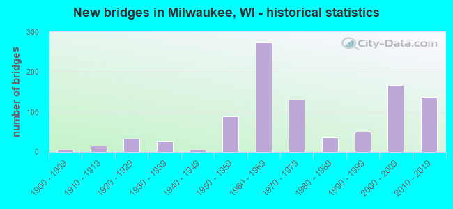
- New bridges - historical statistics
- 1Before 1900
- 61900-1909
- 161910-1919
- 331920-1929
- 271930-1939
- 51940-1949
- 891950-1959
- 2731960-1969
- 1301970-1979
- 371980-1989
- 511990-1999
- 1682000-2009
- 1382010-2019
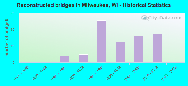
- Reconstructed bridges - Historical Statistics
- 11940-1949
- 11950-1959
- 101960-1969
- 121970-1979
- 641980-1989
- 311990-1999
- 412000-2009
- 432010-2019
- 12020-2022
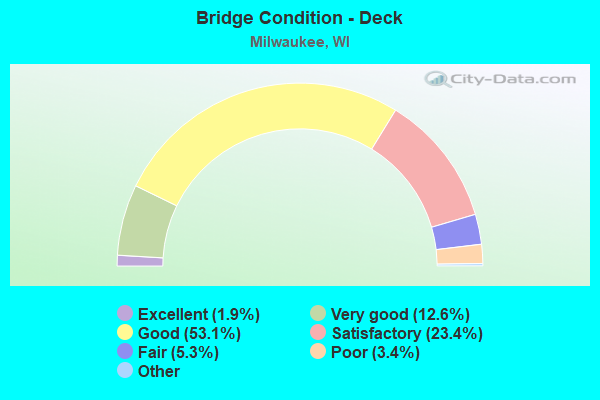
- Bridge Condition - Deck
- 1.9%Excellent
- 12.6%Very good
- 53.1%Good
- 23.4%Satisfactory
- 5.3%Fair
- 3.4%Poor
- 0.4%Serious
- 0.2%Failed
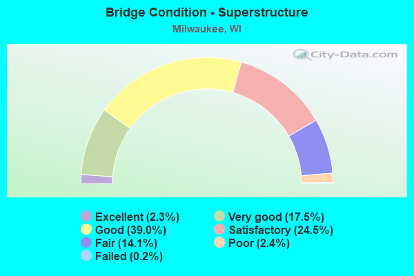
- Bridge Condition - Superstructure
- 2.3%Excellent
- 17.5%Very good
- 39.0%Good
- 24.5%Satisfactory
- 14.1%Fair
- 2.4%Poor
- 0.2%Failed
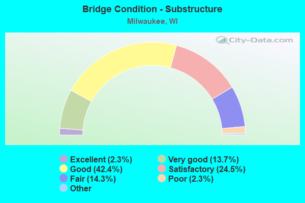
- Bridge Condition - Substructure
- 2.3%Excellent
- 13.7%Very good
- 42.4%Good
- 24.5%Satisfactory
- 14.3%Fair
- 2.3%Poor
- 0.6%Serious
- 0.2%Critical
- 0.2%Failed
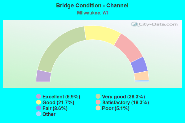
- Bridge Condition - Channel
- 6.9%Excellent
- 38.3%Very good
- 21.7%Good
- 18.3%Satisfactory
- 8.6%Fair
- 5.1%Poor
- 1.1%Serious
- 0.6%Failed
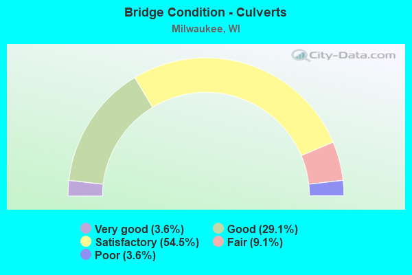
- Bridge Condition - Culverts
- 3.6%Very good
- 29.1%Good
- 54.5%Satisfactory
- 9.1%Fair
- 3.6%Poor
Find on map >> Show street view
Structure Number: B400883, Location: 3.4 MI W JCT IH 43 (Lat: 43.009739, Lng: -88.036572), Route carried "on" structure: Interstate 41, Year Built: 2016, Status: Open, Structure Length: 6.17m (20.24ft), Average Daily Traffic: 87,000 (year 2019), Average Future Daily Traffic: 221,800 (year 2039), Design Load: HL 93, Features Intersected: CNW RR
Minimum Vertical Clearance: 30+ m (98+ ft), Kilometerpoint: 0.000, Lanes on structure: 5, Base Highway Network: Yes, Owner: State Highway Agency, Approaching Roadway Width: 25.6m (84.0ft), Material/Design: Prestressed concrete continuous, Design/Construction: Stringer/Multi-beam, Number Of Spans In Main Unit: 2, Length of Maximum Span: 31.1m (102.0ft), Curb-To-Curb Width: 25.6m (84.0ft), Out-to-Out Width: 26.5m (86.9ft)
Condition: Deck: Good, Superstructure: Very good, Substructure: Very good, Operating Rating: 42.1 metric tons, Method Used To Determine Operating Rating: Load and Resistance Factor Rating (LRFR) rating reported by rating factor(RF) method using HL-93 loadings, Inventory Rating: 32.7 metric tons, Method Used To Determine Inventory Rating: Load and Resistance Factor Rating (LRFR) rating reported by rating factor(RF) method using HL-93 loadings, Structural Evaluation: Equal to present desirable criteria, Deck Geometry: Better than present minimum criteria, Underclear: Superior to present desirable criteria, Approach Roadway Alignment: Equal to present desirable criteria, Designated Inspection Frequency: Every 24 months, Inspection Date: October 2020, Deck Structure Type: Concrete Cast-file-Place, Wearing Surface/Protective System: Wearing Surface: Monolithic Concrete, Deck Protection: Epoxy Coated Reinforcing
Find on map >> Show street view
Structure Number: B400885, Location: 2.7 MI W JCT CARFERRY DR (Lat: 43.036172, Lng: -87.906917), Route carried "on" structure: Interstate 794, Year Built: 2015, Status: Open, Structure Length: 21.02m (68.96ft), Average Daily Traffic: 40,150 (year 2019), Truck Traffic: 8%, Average Future Daily Traffic: 42,700 (year 2040), Design Load: HL 93, Features Intersected: IH RAMP BROADWAY TO IH 7
Minimum Vertical Clearance: 30+ m (98+ ft), Kilometerpoint: 0.000, Lanes on structure: 4, Lanes under structure: 8, Base Highway Network: Yes, Owner: State Highway Agency, Approaching Roadway Width: 29.0m (95.1ft), Material/Design: Steel continuous, Design/Construction: Stringer/Multi-beam, Number Of Spans In Main Unit: 6, Length of Maximum Span: 42.1m (138.1ft), Curb-To-Curb Width: 20.5m (67.3ft), Out-to-Out Width: 21.4m (70.2ft)
Condition: Deck: Good, Superstructure: Good, Substructure: Very good, Operating Rating: 44.4 metric tons, Method Used To Determine Operating Rating: Load and Resistance Factor Rating (LRFR) rating reported by rating factor(RF) method using HL-93 loadings, Inventory Rating: 34.3 metric tons, Method Used To Determine Inventory Rating: Load and Resistance Factor Rating (LRFR) rating reported by rating factor(RF) method using HL-93 loadings, Structural Evaluation: Better than present minimum criteria, Deck Geometry: Equal to present minimum criteria, Underclear: High priority of replacement, Approach Roadway Alignment: Equal to present desirable criteria, Length Of Structure Improvement: 21.46m (70.41ft), Designated Inspection Frequency: Every 48 months, Inspection Date: August 2021, Bridge Improvement Cost: $2,663,000, Roadway Improvement Cost: $266,000, Total Project Cost: $3,995,000 ( Estimate for 2021), Deck Structure Type: Concrete Cast-file-Place, Wearing Surface/Protective System: Wearing Surface: Epoxy Overlay, Deck Protection: Epoxy Coated Reinforcing
Find on map >> Show street view
Structure Number: B400886, Location: @ MILWAUKEE ST. (Lat: 43.036011, Lng: -87.905308), Route carried "on" structure: Ramp Interstate 794, Year Built: 2015, Status: Open, Structure Length: 12.90m (42.32ft), Average Daily Traffic: 14,360 (year 2019), Truck Traffic: 8%, Average Future Daily Traffic: 17,200 (year 2040), Design Load: HL 93, Features Intersected: STH 32 / MILWAUKEE ST, Facility Carried by Structure: IH ON-RAMP, JACKSO
Minimum Vertical Clearance: 30+ m (98+ ft), Kilometerpoint: 0.000, Lanes on structure: 2, Lanes under structure: 2, Owner: State Highway Agency, Approaching Roadway Width: 10.4m (34.1ft), Material/Design: Steel continuous, Design/Construction: Stringer/Multi-beam, Number Of Spans In Main Unit: 3, Length of Maximum Span: 49.3m (161.7ft), Curb-To-Curb Width: 11.6m (38.1ft), Out-to-Out Width: 12.4m (40.7ft)
Condition: Deck: Good, Superstructure: Good, Substructure: Very good, Operating Rating: 44.4 metric tons, Method Used To Determine Operating Rating: Load and Resistance Factor Rating (LRFR) rating reported by rating factor(RF) method using HL-93 loadings, Inventory Rating: 34.3 metric tons, Method Used To Determine Inventory Rating: Load and Resistance Factor Rating (LRFR) rating reported by rating factor(RF) method using HL-93 loadings, Structural Evaluation: Better than present minimum criteria, Deck Geometry: Superior to present desirable criteria, Underclear: Equal to present minimum criteria, Approach Roadway Alignment: Equal to present desirable criteria, Designated Inspection Frequency: Every 48 months, Inspection Date: August 2021, Deck Structure Type: Concrete Cast-file-Place, Wearing Surface/Protective System: Wearing Surface: Epoxy Overlay, Deck Protection: Epoxy Coated Reinforcing
Find on map >> Show street view
Structure Number: B400887, Location: 0.8 MI E JCT IH 43 (Lat: 43.035536, Lng: -87.909475), Route carried "on" structure: Interstate 794, Year Built: 2014, Status: Open, Structure Length: 25.10m (82.35ft), Average Daily Traffic: 40,150 (year 2019), Truck Traffic: 8%, Average Future Daily Traffic: 45,700 (year 2035), Design Load: HL 93, Features Intersected: IH RAMP BROADWAY ST-IH 7
Minimum Vertical Clearance: 6.52m (21.39ft), Kilometerpoint: 0.000, Lanes on structure: 3, Lanes under structure: 2, Base Highway Network: Yes, Owner: State Highway Agency, Approaching Roadway Width: 18.6m (61.0ft), Material/Design: Steel continuous, Design/Construction: Stringer/Multi-beam, Number Of Spans In Main Unit: 7, Length of Maximum Span: 40.7m (133.5ft), Curb-To-Curb Width: 18.7m (61.4ft), Out-to-Out Width: 19.6m (64.3ft)
Condition: Deck: Very good, Superstructure: Excellent, Substructure: Excellent, Operating Rating: 42.1 metric tons, Method Used To Determine Operating Rating: Load and Resistance Factor Rating (LRFR) rating reported by rating factor(RF) method using HL-93 loadings, Inventory Rating: 32.7 metric tons, Method Used To Determine Inventory Rating: Load and Resistance Factor Rating (LRFR) rating reported by rating factor(RF) method using HL-93 loadings, Structural Evaluation: Superior to present desirable criteria, Deck Geometry: Superior to present desirable criteria, Underclear: Equal to present minimum criteria, Approach Roadway Alignment: Equal to present desirable criteria, Designated Inspection Frequency: Every 48 months, Inspection Date: August 2018, Deck Structure Type: Concrete Cast-file-Place, Wearing Surface/Protective System: Wearing Surface: Epoxy Overlay, Deck Protection: Epoxy Coated Reinforcing
Find on map >> Show street view
Structure Number: B400888, Location: 0.9 MI E JCT IH-43 (Lat: 43.035678, Lng: -87.906411), Route carried "on" structure: Ramp Interstate 794, Year Built: 2014, Status: Open, Structure Length: 12.84m (42.13ft), Average Daily Traffic: 4,300 (year 2019), Truck Traffic: 8%, Average Future Daily Traffic: 15,950 (year 2035), Design Load: HL 93, Features Intersected: STH 32/MILWAUKEE ST.
Minimum Vertical Clearance: 30+ m (98+ ft), Kilometerpoint: 0.000, Lanes on structure: 3, Lanes under structure: 2, Owner: State Highway Agency, Approaching Roadway Width: 15.2m (49.9ft), Material/Design: Steel continuous, Design/Construction: Stringer/Multi-beam, Number Of Spans In Main Unit: 2, Length of Maximum Span: 66.8m (219.2ft), Curb-To-Curb Width: 13.7m (44.9ft), Out-to-Out Width: 14.5m (47.6ft)
Condition: Deck: Excellent, Superstructure: Excellent, Substructure: Excellent, Operating Rating: 38.9 metric tons, Method Used To Determine Operating Rating: Load and Resistance Factor Rating (LRFR) rating reported by rating factor(RF) method using HL-93 loadings, Inventory Rating: 29.8 metric tons, Method Used To Determine Inventory Rating: Load and Resistance Factor Rating (LRFR) rating reported by rating factor(RF) method using HL-93 loadings, Structural Evaluation: Better than present minimum criteria, Deck Geometry: Equal to present minimum criteria, Underclear: Somewhat better than minimum adequacy, Approach Roadway Alignment: Equal to present desirable criteria, Designated Inspection Frequency: Every 48 months, Inspection Date: September 2018, Deck Structure Type: Concrete Cast-file-Place, Wearing Surface/Protective System: Wearing Surface: Epoxy Overlay, Deck Protection: Epoxy Coated Reinforcing
Find on map >> Show street view
Structure Number: B40089, Location: 0.3 MI W JCT USH 45 (Lat: 43.026942, Lng: -88.041608), Route carried "on" structure: Interstate 94, Year Built: 2014, Status: Open, Structure Length: 0.98m (3.22ft), Average Daily Traffic: 80,500 (year 2019), Average Future Daily Traffic: 37,436 (year 2039), Design Load: HL 93, Features Intersected: LRD ZOO ACCESS ROAD TUNN, Facility Carried by Structure: IH RAMP, STH 100 -
Minimum Vertical Clearance: 30+ m (98+ ft), Kilometerpoint: 0.000, Lanes on structure: 2, Lanes under structure: 1, Base Highway Network: Yes, Owner: State Highway Agency, Approaching Roadway Width: 14.6m (47.9ft), Material/Design: Prestressed concrete, Design/Construction: Tee Beam, Number Of Spans In Main Unit: 1, Length of Maximum Span: 8.7m (28.5ft), Curb-To-Curb Width: 14.6m (47.9ft), Out-to-Out Width: 29.2m (95.8ft)
Condition: Deck: Excellent, Superstructure: Excellent, Substructure: Excellent, Operating Rating: 90.4 metric tons, Method Used To Determine Operating Rating: Load and Resistance Factor Rating (LRFR) rating reported by rating factor(RF) method using HL-93 loadings, Inventory Rating: 75.5 metric tons, Method Used To Determine Inventory Rating: Load and Resistance Factor Rating (LRFR) rating reported by rating factor(RF) method using HL-93 loadings, Structural Evaluation: Superior to present desirable criteria, Deck Geometry: Superior to present desirable criteria, Underclear: High priority of replacement, Approach Roadway Alignment: Equal to present desirable criteria, Length Of Structure Improvement: 1.43m (4.69ft), Designated Inspection Frequency: Every 24 months, Inspection Date: July 2020, Bridge Improvement Cost: $177,000, Roadway Improvement Cost: $17,000, Total Project Cost: $266,000 ( Estimate for 2021), Deck Structure Type: Concrete Cast-file-Place, Wearing Surface/Protective System: Deck Protection: Epoxy Coated Reinforcing
Find on map >> Show street view
Structure Number: B400891, Location: 0.3 MI W JCT USH 45 (Lat: 43.027550, Lng: -88.041436), Route carried "on" structure: Ramp Interstate 94, Year Built: 2015, Status: Open, Structure Length: 2.12m (6.96ft), Average Daily Traffic: 6,700 (year 2019), Average Future Daily Traffic: 7,250 (year 2037), Design Load: HL 93, Features Intersected: LRD SERVICE RD
Minimum Vertical Clearance: 5.44m (17.85ft), Kilometerpoint: 0.000, Lanes on structure: 1, Lanes under structure: 1, Owner: State Highway Agency, Approaching Roadway Width: 8.2m (26.9ft), Material/Design: Steel, Design/Construction: Stringer/Multi-beam, Number Of Spans In Main Unit: 1, Length of Maximum Span: 19.8m (65.0ft), Curb-To-Curb Width: 8.2m (26.9ft), Out-to-Out Width: 9.1m (29.9ft)
Condition: Deck: Very good, Superstructure: Excellent, Substructure: Very good, Operating Rating: 49.2 metric tons, Method Used To Determine Operating Rating: Load and Resistance Factor Rating (LRFR) rating reported by rating factor(RF) method using HL-93 loadings, Inventory Rating: 37.9 metric tons, Method Used To Determine Inventory Rating: Load and Resistance Factor Rating (LRFR) rating reported by rating factor(RF) method using HL-93 loadings, Structural Evaluation: Equal to present desirable criteria, Deck Geometry: Superior to present desirable criteria, Underclear: High priority of replacement, Approach Roadway Alignment: Equal to present minimum criteria, Length Of Structure Improvement: 2.56m (8.40ft), Designated Inspection Frequency: Every 24 months, Inspection Date: November 2021, Bridge Improvement Cost: $319,000, Roadway Improvement Cost: $31,000, Total Project Cost: $479,000 ( Estimate for 2021), Deck Structure Type: Concrete Cast-file-Place, Wearing Surface/Protective System: Wearing Surface: Monolithic Concrete, Deck Protection: Epoxy Coated Reinforcing
Find on map >> Show street view
Structure Number: B400892, Location: 0.9 MI E JCT USH 45 (Lat: 43.027233, Lng: -88.018244), Route carried "on" structure: City street , Year Built: 2014, Status: Open, Structure Length: 1.58m (5.18ft), Average Daily Traffic: 15,500 (year 2019), Average Future Daily Traffic: 85,200 (year 2039), Design Load: HL 93, Features Intersected: HONEY CREEK, Facility Carried by Structure: LRD S 84TH ST/KEAR
Minimum Vertical Clearance: 30+ m (98+ ft), Kilometerpoint: 0.000, Lanes on structure: 4, Base Highway Network: Yes, Owner: State Highway Agency, Approaching Roadway Width: 18.3m (60.0ft), Material/Design: Concrete, Design/Construction: Culvert, Number Of Spans In Main Unit: 2, Length of Maximum Span: 3.7m (12.1ft)
Condition: Channel: Excellent, Culverts: Very good, Operating Rating: 54.3 metric tons, Method Used To Determine Operating Rating: Field evaluation and documented engineering judgment, Inventory Rating: 36.0 metric tons, Method Used To Determine Inventory Rating: Field evaluation and documented engineering judgment, Structural Evaluation: Equal to present desirable criteria, Waterway Adequacy: Superior to present desirable criteria, Approach Roadway Alignment: Equal to present desirable criteria, Designated Inspection Frequency: Every 48 months, Inspection Date: August 2020, Deck Structure Type: Concrete Cast-file-Place
Find on map >> Show street view
Structure Number: B400899, Location: 0.7M W JCT STH 57 (Lat: 43.053953, Lng: -87.951850), Route carried "on" structure: City street , Year Built: 2014, Status: Open, Structure Length: 2.04m (6.69ft), Average Daily Traffic: 11,700 (year 2018), Average Future Daily Traffic: 16,747 (year 2039), Design Load: HL 93, Features Intersected: CANADIAN PACIFIC RR, Facility Carried by Structure: LRD W LISBON AVE
Minimum Vertical Clearance: 30+ m (98+ ft), Kilometerpoint: 0.000, Lanes on structure: 2, Owner: City or Municipal Highway Agency, Approaching Roadway Width: 15.2m (49.9ft), Material/Design: Concrete, Design/Construction: Frame, Number Of Spans In Main Unit: 1, Length of Maximum Span: 19.4m (63.6ft), Curb or Sidewalk Widths: Left: 2.0m (6.6ft), Right: 2.0m (6.6ft), Curb-To-Curb Width: 15.2m (49.9ft), Out-to-Out Width: 20.1m (65.9ft)
Condition: Deck: Good, Superstructure: Good, Substructure: Good, Operating Rating: 46.7 metric tons, Method Used To Determine Operating Rating: Load and Resistance Factor Rating (LRFR) rating reported by rating factor(RF) method using HL-93 loadings, Inventory Rating: 36.0 metric tons, Method Used To Determine Inventory Rating: Load and Resistance Factor Rating (LRFR) rating reported by rating factor(RF) method using HL-93 loadings, Structural Evaluation: Better than present minimum criteria, Deck Geometry: Superior to present desirable criteria, Underclear: Equal to present desirable criteria, Approach Roadway Alignment: Equal to present desirable criteria, Designated Inspection Frequency: Every 48 months, Inspection Date: September 2020, Deck Structure Type: Concrete Cast-file-Place, Wearing Surface/Protective System: Wearing Surface: Monolithic Concrete
Find on map >> Show street view
Structure Number: B400914, Location: AT JCT WITH STH 190 (Lat: 43.089081, Lng: -87.917069), Route carried "on" structure: City street , Year Built: 2019, Status: Open, Structure Length: 3.52m (11.55ft), Average Daily Traffic: 11,200 (year 2018), Truck Traffic: 5%, Average Future Daily Traffic: 13,000 (year 2040), Design Load: HL 93, Features Intersected: STH 190-CAPITOL DR, Facility Carried by Structure: LRD N PORT WASHING
Minimum Vertical Clearance: 30+ m (98+ ft), Kilometerpoint: 0.000, Lanes on structure: 2, Lanes under structure: 6, Base Highway Network: Yes, Owner: City or Municipal Highway Agency, Approaching Roadway Width: 17.1m (56.1ft), Material/Design: Steel continuous, Design/Construction: Stringer/Multi-beam, Number Of Spans In Main Unit: 2, Length of Maximum Span: 16.9m (55.4ft), Curb or Sidewalk Widths: Left: 2.0m (6.6ft), Right: 2.0m (6.6ft), Curb-To-Curb Width: 17.1m (56.1ft), Out-to-Out Width: 21.4m (70.2ft)
Condition: Deck: Very good, Superstructure: Excellent, Substructure: Excellent, Operating Rating: 46.3 metric tons, Method Used To Determine Operating Rating: Load and Resistance Factor Rating (LRFR) rating reported by rating factor(RF) method using HL-93 loadings, Inventory Rating: 35.6 metric tons, Method Used To Determine Inventory Rating: Load and Resistance Factor Rating (LRFR) rating reported by rating factor(RF) method using HL-93 loadings, Structural Evaluation: Superior to present desirable criteria, Deck Geometry: Superior to present desirable criteria, Underclear: High priority of replacement, Approach Roadway Alignment: Equal to present desirable criteria, Length Of Structure Improvement: 3.96m (12.99ft), Designated Inspection Frequency: Every 48 months, Inspection Date: November 2021, Bridge Improvement Cost: $634,000, Roadway Improvement Cost: $63,000, Total Project Cost: $951,000 ( Estimate for 2021), Deck Structure Type: Concrete Cast-file-Place, Wearing Surface/Protective System: Wearing Surface: Monolithic Concrete, Deck Protection: Epoxy Coated Reinforcing
Find on map >> Show street view
Structure Number: B400915, Location: 1.1 MI E JCT IH 43 (Lat: 43.035653, Lng: -87.902989), Route carried "on" structure: Ramp Interstate 794, Year Built: 2016, Status: Open, Structure Length: 10.91m (35.79ft), Average Daily Traffic: 9,200 (year 2019), Truck Traffic: 4%, Average Future Daily Traffic: 13,300 (year 2036), Design Load: HL 93, Features Intersected: LRD N VAN BUREN ST
Minimum Vertical Clearance: 30+ m (98+ ft), Kilometerpoint: 0.000, Lanes on structure: 2, Lanes under structure: 2, Owner: State Highway Agency, Approaching Roadway Width: 12.2m (40.0ft), Material/Design: Steel continuous, Design/Construction: Stringer/Multi-beam, Number Of Spans In Main Unit: 3, Length of Maximum Span: 38.1m (125.0ft), Curb-To-Curb Width: 12.2m (40.0ft), Out-to-Out Width: 13.0m (42.7ft)
Condition: Deck: Very good, Superstructure: Very good, Substructure: Excellent, Operating Rating: 52.8 metric tons, Method Used To Determine Operating Rating: Load and Resistance Factor Rating (LRFR) rating reported by rating factor(RF) method using HL-93 loadings, Inventory Rating: 40.5 metric tons, Method Used To Determine Inventory Rating: Load and Resistance Factor Rating (LRFR) rating reported by rating factor(RF) method using HL-93 loadings, Structural Evaluation: Equal to present desirable criteria, Deck Geometry: Superior to present desirable criteria, Underclear: Better than present minimum criteria, Approach Roadway Alignment: Equal to present minimum criteria, Designated Inspection Frequency: Every 48 months, Inspection Date: April 2018, Deck Structure Type: Concrete Cast-file-Place, Wearing Surface/Protective System: Wearing Surface: Epoxy Overlay, Deck Protection: Epoxy Coated Reinforcing
Find on map >> Show street view
Structure Number: B400916, Location: 1.1 MI E JCT IH 43 (Lat: 43.036458, Lng: -87.902808), Route carried "on" structure: Ramp Interstate 794, Year Built: 2016, Status: Open, Structure Length: 13.75m (45.11ft), Average Daily Traffic: 10,700 (year 2019), Truck Traffic: 4%, Average Future Daily Traffic: 14,600 (year 2036), Design Load: HL 93, Features Intersected: IH RAMP IH 794 EB TO JAC, Facility Carried by Structure: IH RAMP LAKE FRWY-
Minimum Vertical Clearance: 6.69m (21.95ft), Kilometerpoint: 0.000, Lanes on structure: 2, Lanes under structure: 2, Owner: State Highway Agency, Approaching Roadway Width: 14.0m (45.9ft), Skew: 1 degrees, Material/Design: Steel continuous, Design/Construction: Stringer/Multi-beam, Number Of Spans In Main Unit: 4, Length of Maximum Span: 42.7m (140.1ft), Curb-To-Curb Width: 12.2m (40.0ft), Out-to-Out Width: 13.0m (42.7ft)
Condition: Deck: Very good, Superstructure: Very good, Substructure: Excellent, Operating Rating: 55.7 metric tons, Method Used To Determine Operating Rating: Load and Resistance Factor Rating (LRFR) rating reported by rating factor(RF) method using HL-93 loadings, Inventory Rating: 43.1 metric tons, Method Used To Determine Inventory Rating: Load and Resistance Factor Rating (LRFR) rating reported by rating factor(RF) method using HL-93 loadings, Structural Evaluation: Equal to present desirable criteria, Deck Geometry: Superior to present desirable criteria, Underclear: Superior to present desirable criteria, Approach Roadway Alignment: Equal to present desirable criteria, Designated Inspection Frequency: Every 48 months, Inspection Date: April 2018, Deck Structure Type: Concrete Cast-file-Place, Wearing Surface/Protective System: Wearing Surface: Epoxy Overlay, Deck Protection: Epoxy Coated Reinforcing
Find on map >> Show street view
Structure Number: B400923, Location: 0.6M N JCT STH 145 (Lat: 43.099394, Lng: -87.976700), Route carried "on" structure: City street , Year Built: 2017, Status: Open, Structure Length: 3.66m (12.01ft), Average Daily Traffic: 14,300 (year 2019), Truck Traffic: 9%, Average Future Daily Traffic: 11,700 (year 2036), Design Load: HL 93, Features Intersected: LINCOLN CREEK, Facility Carried by Structure: LRD N 51ST BLVD
Minimum Vertical Clearance: 30+ m (98+ ft), Kilometerpoint: 0.000, Lanes on structure: 3, Owner: City or Municipal Highway Agency, Approaching Roadway Width: 20.1m (65.9ft), Skew: 1 degrees, Material/Design: Concrete continuous, Design/Construction: Slab, Number Of Spans In Main Unit: 3, Length of Maximum Span: 14.3m (46.9ft), Curb or Sidewalk Widths: Left: 2.0m (6.6ft), Right: 2.0m (6.6ft), Curb-To-Curb Width: 20.1m (65.9ft), Out-to-Out Width: 25.4m (83.3ft)
Condition: Deck: Good, Superstructure: Good, Substructure: Good, Channel: Very good, Operating Rating: 46.7 metric tons, Method Used To Determine Operating Rating: Load and Resistance Factor Rating (LRFR) rating reported by rating factor(RF) method using HL-93 loadings, Inventory Rating: 36.0 metric tons, Method Used To Determine Inventory Rating: Load and Resistance Factor Rating (LRFR) rating reported by rating factor(RF) method using HL-93 loadings, Structural Evaluation: Better than present minimum criteria, Deck Geometry: Superior to present desirable criteria, Waterway Adequacy: Superior to present desirable criteria, Approach Roadway Alignment: Equal to present desirable criteria, Designated Inspection Frequency: Every 48 months, Inspection Date: June 2020, Deck Structure Type: Concrete Cast-file-Place, Wearing Surface/Protective System: Wearing Surface: Monolithic Concrete, Deck Protection: Epoxy Coated Reinforcing
Find on map >> Show street view
Structure Number: B400925, Location: 0.7M W JCT STH 57 (Lat: 43.056419, Lng: -87.951758), Route carried "on" structure: City street , Year Built: 2018, Status: Open, Structure Length: 1.77m (5.81ft), Average Daily Traffic: 3,200 (year 2018), Average Future Daily Traffic: 1,500 (year 2039), Design Load: HL 93, Features Intersected: CANADIAN PACIFIC RR, Facility Carried by Structure: LRD W BROWN ST
Minimum Vertical Clearance: 7.01m (23.00ft), Kilometerpoint: 0.000, Lanes on structure: 2, Owner: City or Municipal Highway Agency, Approaching Roadway Width: 11.0m (36.1ft), Material/Design: Concrete, Design/Construction: Slab, Number Of Spans In Main Unit: 1, Length of Maximum Span: 16.8m (55.1ft), Curb or Sidewalk Widths: Left: 2.0m (6.6ft), Right: 2.0m (6.6ft), Curb-To-Curb Width: 11.0m (36.1ft), Out-to-Out Width: 15.8m (51.8ft)
Condition: Deck: Very good, Superstructure: Very good, Substructure: Excellent, Operating Rating: 43.4 metric tons, Method Used To Determine Operating Rating: Load and Resistance Factor Rating (LRFR) rating reported by rating factor(RF) method using HL-93 loadings, Inventory Rating: 33.4 metric tons, Method Used To Determine Inventory Rating: Load and Resistance Factor Rating (LRFR) rating reported by rating factor(RF) method using HL-93 loadings, Structural Evaluation: Equal to present desirable criteria, Deck Geometry: Somewhat better than minimum adequacy, Underclear: Equal to present desirable criteria, Approach Roadway Alignment: Equal to present desirable criteria, Designated Inspection Frequency: Every 48 months, Inspection Date: November 2020, Deck Structure Type: Concrete Cast-file-Place, Wearing Surface/Protective System: Wearing Surface: Monolithic Concrete, Deck Protection: Epoxy Coated Reinforcing
Find on map >> Show street view
Structure Number: B400936, Location: 0.5M S JCT STH 32 (Lat: 42.912136, Lng: -87.853222), Route carried "on" structure: City street , Year Built: 1931, Status: Open, Structure Length: 1.46m (4.79ft), Average Daily Traffic: 5,200 (year 2018), Average Future Daily Traffic: 5,551 (year 2039), Design Load: H 15, Features Intersected: OAK CREEK, Facility Carried by Structure: LRD MILL RD
Minimum Vertical Clearance: 30+ m (98+ ft), Kilometerpoint: 0.000, Lanes on structure: 2, Owner: County Highway Agency, Approaching Roadway Width: 9.1m (29.9ft), Material/Design: Concrete, Design/Construction: Arch - Deck, Number Of Spans In Main Unit: 1, Length of Maximum Span: 9.1m (29.9ft), Curb or Sidewalk Widths: Left: 2.0m (6.6ft), Right: 2.0m (6.6ft), Curb-To-Curb Width: 9.1m (29.9ft), Out-to-Out Width: 13.6m (44.6ft)
Condition: Deck: Satisfactory, Superstructure: Satisfactory, Substructure: Satisfactory, Channel: Good, Operating Rating: 53.9 metric tons, Method Used To Determine Operating Rating: Field evaluation and documented engineering judgment, Inventory Rating: 32.4 metric tons, Method Used To Determine Inventory Rating: Field evaluation and documented engineering judgment, Structural Evaluation: Equal to present minimum criteria, Deck Geometry: High priority of corrective action, Waterway Adequacy: Equal to present desirable criteria, Approach Roadway Alignment: Equal to present desirable criteria, Length Of Structure Improvement: 1.92m (6.30ft), Designated Inspection Frequency: Every 24 months, Inspection Date: June 2020, Bridge Improvement Cost: $306,000, Roadway Improvement Cost: $30,000, Total Project Cost: $459,000 ( Estimate for 2021), Deck Structure Type: Concrete Cast-file-Place, Wearing Surface/Protective System: Wearing Surface: Monolithic Concrete
Find on map >> Show street view
Structure Number: B400939, Location: 0.2 MI N JCT IH 41 (Lat: 43.131725, Lng: -88.053944), Route carried "on" structure: Ramp Interstate 41, Year Built: 1953, Year Reconstructed: 1988, Status: Open, Structure Length: 4.50m (14.76ft), Average Daily Traffic: 8,300 (year 2019), Truck Traffic: 6%, Average Future Daily Traffic: 17,400 (year 2039), Design Load: H 20, Features Intersected: STH 175 SB
Minimum Vertical Clearance: 30+ m (98+ ft), Kilometerpoint: 0.000, Lanes on structure: 1, Lanes under structure: 2, Owner: State Highway Agency, Approaching Roadway Width: 9.8m (32.2ft), Material/Design: Steel continuous, Design/Construction: Stringer/Multi-beam, Number Of Spans In Main Unit: 3, Length of Maximum Span: 17.2m (56.4ft), Curb-To-Curb Width: 9.8m (32.2ft), Out-to-Out Width: 10.7m (35.1ft)
Condition: Deck: Good, Superstructure: Fair, Substructure: Fair, Operating Rating: 57.0 metric tons, Method Used To Determine Operating Rating: Load Factor (LF), Inventory Rating: 34.0 metric tons, Method Used To Determine Inventory Rating: Load Factor (LF), Structural Evaluation: Somewhat better than minimum adequacy, Deck Geometry: Superior to present desirable criteria, Underclear: High priority of replacement, Approach Roadway Alignment: Equal to present desirable criteria, Length Of Structure Improvement: 4.94m (16.21ft), Designated Inspection Frequency: Every 24 months, Inspection Date: July 2020, Bridge Improvement Cost: $615,000, Roadway Improvement Cost: $61,000, Total Project Cost: $923,000 ( Estimate for 2021), Deck Structure Type: Concrete Cast-file-Place, Wearing Surface/Protective System: Wearing Surface: Other, Deck Protection: Epoxy Coated Reinforcing
Find on map >> Show street view
Structure Number: B40094, Location: 0.8 MI S JCT CTH PP (Lat: 43.136872, Lng: -88.056225), Route carried "on" structure: Interstate 41, Year Built: 1952, Year Reconstructed: 1988, Status: Open, Structure Length: 4.50m (14.76ft), Average Daily Traffic: 1,300 (year 2019), Truck Traffic: 3%, Average Future Daily Traffic: 27,835 (year 2039), Design Load: HS 20, Features Intersected: STH 175 NB
Minimum Vertical Clearance: 30+ m (98+ ft), Kilometerpoint: 0.000, Lanes on structure: 2, Lanes under structure: 2, Base Highway Network: Yes, Owner: State Highway Agency, Approaching Roadway Width: 12.2m (40.0ft), Material/Design: Steel continuous, Design/Construction: Stringer/Multi-beam, Number Of Spans In Main Unit: 3, Length of Maximum Span: 17.2m (56.4ft), Curb-To-Curb Width: 12.2m (40.0ft), Out-to-Out Width: 13.0m (42.7ft)
Condition: Deck: Good, Superstructure: Fair, Substructure: Fair, Operating Rating: 55.5 metric tons, Method Used To Determine Operating Rating: Load Factor (LF), Inventory Rating: 32.4 metric tons, Method Used To Determine Inventory Rating: Load Factor (LF), Structural Evaluation: Somewhat better than minimum adequacy, Deck Geometry: Better than present minimum criteria, Underclear: Meets minimum limits, Approach Roadway Alignment: Equal to present desirable criteria, Designated Inspection Frequency: Every 24 months, Inspection Date: July 2020, Deck Structure Type: Concrete Cast-file-Place, Wearing Surface/Protective System: Wearing Surface: Other, Deck Protection: Epoxy Coated Reinforcing
Find on map >> Show street view
Structure Number: B40098, Location: 0.4M W JCT STH 32 TO N (Lat: 43.042856, Lng: -87.913694), Route carried "on" structure: US 18, Year Built: 1924, Status: Open, Structure Length: 8.35m (27.40ft), Average Daily Traffic: 5,894 (year 2019), Truck Traffic: 6%, Average Future Daily Traffic: 6,642 (year 2039), Design Load: H 15, Features Intersected: MILWAUKEE RIVER
Minimum Vertical Clearance: 30+ m (98+ ft), Kilometerpoint: 0.000, Lanes on structure: 3, Owner: City or Municipal Highway Agency, Approaching Roadway Width: 16.5m (54.1ft), Skew: 1 degrees, Material/Design: Steel, Design/Construction: Movable - Bascule, Number Of Spans In Main Unit: 1, Number Of Approach Spans: 1, Length of Maximum Span: 36.3m (119.1ft), Curb or Sidewalk Widths: Left: 3.1m (10.2ft), Right: 3.1m (10.2ft), Curb-To-Curb Width: 12.5m (41.0ft), Out-to-Out Width: 24.6m (80.7ft)
Condition: Deck: Good, Superstructure: Good, Substructure: Fair, Channel: Good, Operating Rating: 45.7 metric tons, Method Used To Determine Operating Rating: Load Factor (LF), Inventory Rating: 29.2 metric tons, Method Used To Determine Inventory Rating: Load Factor (LF), Structural Evaluation: Somewhat better than minimum adequacy, Deck Geometry: Meets minimum limits, Waterway Adequacy: Superior to present desirable criteria, Approach Roadway Alignment: Equal to present desirable criteria, Designated Inspection Frequency: Every 24 months, Critical Feature Inspection Frequency: Every 24 months, Underwater Inspection Frequency: Every 60 months, Other Special Inspection Frequency: Every 24 months, Inspection Date: May 2020, Critical Feature Inspection Date: May 2021, Underwater Inspection Date: June 2018, Other Special Inspection Date: May 2021, Deck Structure Type: Open Grating, Wearing Surface/Protective System: Wearing Surface: Other
Find on map >> Show street view
Structure Number: B400986, Location: 0.2M N JCT IH 94 TO E (Lat: 43.029433, Lng: -88.017125), Route carried "on" structure: State highway 181, Year Built: 1934, Status: Open, Structure Length: 1.08m (3.54ft), Average Daily Traffic: 15,500 (year 2019), Truck Traffic: 3%, Average Future Daily Traffic: 19,577 (year 2040), Design Load: HS 20, Features Intersected: HONEY CREEK
Minimum Vertical Clearance: 30+ m (98+ ft), Kilometerpoint: 0.000, Lanes on structure: 4, Base Highway Network: Yes, Owner: City or Municipal Highway Agency, Approaching Roadway Width: 20.7m (67.9ft), Skew: 30 degrees, Material/Design: Concrete continuous, Design/Construction: Frame, Number Of Spans In Main Unit: 1, Length of Maximum Span: 9.1m (29.9ft), Curb or Sidewalk Widths: Left: 2.8m (9.2ft), Right: 2.8m (9.2ft), Curb-To-Curb Width: 20.7m (67.9ft), Out-to-Out Width: 31.1m (102.0ft)
Condition: Deck: Poor, Superstructure: Poor, Substructure: Fair, Channel: Poor, Operating Rating: 65.0 metric tons, Method Used To Determine Operating Rating: Load Factor (LF), Inventory Rating: 37.3 metric tons, Method Used To Determine Inventory Rating: Load Factor (LF), Structural Evaluation: Meets minimum limits, Deck Geometry: Superior to present desirable criteria, Waterway Adequacy: Better than present minimum criteria, Approach Roadway Alignment: Equal to present desirable criteria, Length Of Structure Improvement: 1.52m (4.99ft), Designated Inspection Frequency: Every 12 months, Inspection Date: July 2021, Bridge Improvement Cost: $244,000, Roadway Improvement Cost: $24,000, Total Project Cost: $366,000 ( Estimate for 2021), Deck Structure Type: Concrete Cast-file-Place, Wearing Surface/Protective System: Wearing Surface: Bituminous
Find on map >> Show street view
Structure Number: B4011110001, Location: 0.52 M S OFIH-43/WEL (Lat: 43.032539, Lng: -87.922478), Route carried "on" structure: Interstate 43, Year Built: 2006, Status: Open, Structure Length: 23.55m (77.26ft), Average Daily Traffic: 38,000 (year 2019), Truck Traffic: 11%, Average Future Daily Traffic: 38,900 (year 2037), Design Load: HS 25 or greater, Features Intersected: LRD ST PAUL AVE
Minimum Vertical Clearance: 5.36m (17.59ft), Kilometerpoint: 0.000, Lanes on structure: 2, Lanes under structure: 2, Base Highway Network: Yes, Owner: State Highway Agency, Approaching Roadway Width: 25.3m (83.0ft), Material/Design: Steel continuous, Design/Construction: Stringer/Multi-beam, Number Of Spans In Main Unit: 5, Length of Maximum Span: 51.7m (169.6ft), Curb-To-Curb Width: 17.1m (56.1ft), Out-to-Out Width: 17.9m (58.7ft)
Condition: Deck: Satisfactory, Superstructure: Good, Substructure: Good, Operating Rating: 53.9 metric tons, Method Used To Determine Operating Rating: Load Factor (LF), Inventory Rating: 32.4 metric tons, Method Used To Determine Inventory Rating: Load Factor (LF), Structural Evaluation: Better than present minimum criteria, Deck Geometry: Superior to present desirable criteria, Underclear: Superior to present desirable criteria, Approach Roadway Alignment: Equal to present desirable criteria, Designated Inspection Frequency: Every 24 months, Inspection Date: September 2020, Deck Structure Type: Concrete Cast-file-Place, Wearing Surface/Protective System: Wearing Surface: Other, Deck Protection: Epoxy Coated Reinforcing
Find on map >> Show street view
Structure Number: B4011110002, Location: 0.4M S OF IH-43/WELLS (Lat: 43.034906, Lng: -87.923164), Route carried "on" structure: Interstate 43, Year Built: 2006, Status: Open, Structure Length: 31.09m (102.00ft), Average Daily Traffic: 40,700 (year 2019), Truck Traffic: 11%, Average Future Daily Traffic: 32,200 (year 2037), Design Load: HS 25 or greater, Features Intersected: IH 794
Minimum Vertical Clearance: 5.30m (17.39ft), Kilometerpoint: 0.000, Lanes on structure: 2, Lanes under structure: 10, Base Highway Network: Yes, Owner: State Highway Agency, Approaching Roadway Width: 17.1m (56.1ft), Skew: 2 degrees, Material/Design: Steel continuous, Design/Construction: Stringer/Multi-beam, Number Of Spans In Main Unit: 7, Length of Maximum Span: 53.3m (174.9ft), Curb-To-Curb Width: 17.1m (56.1ft), Out-to-Out Width: 17.8m (58.4ft)
Condition: Deck: Good, Superstructure: Good, Substructure: Good, Operating Rating: 67.0 metric tons, Method Used To Determine Operating Rating: Load Factor (LF), Inventory Rating: 38.9 metric tons, Method Used To Determine Inventory Rating: Load Factor (LF), Structural Evaluation: Better than present minimum criteria, Deck Geometry: Superior to present desirable criteria, Underclear: Meets minimum limits, Approach Roadway Alignment: Equal to present desirable criteria, Designated Inspection Frequency: Every 48 months, Inspection Date: September 2020, Deck Structure Type: Concrete Cast-file-Place, Wearing Surface/Protective System: Wearing Surface: Other, Deck Protection: Epoxy Coated Reinforcing
Find on map >> Show street view
Structure Number: B401121, Location: 0.5 MI N JCT STH 59 (Lat: 43.029400, Lng: -87.922383), Route carried "on" structure: Ramp Interstate 43, Year Built: 2011, Status: Open, Structure Length: 26.93m (88.35ft), Average Daily Traffic: 12,000 (year 2019), Truck Traffic: 7%, Average Future Daily Traffic: 27,500 (year 2037), Design Load: HS 25 or greater, Features Intersected: LRD CANAL ST/CPRR/MENOMO
Minimum Vertical Clearance: 30+ m (98+ ft), Kilometerpoint: 0.000, Lanes on structure: 1, Lanes under structure: 4, Owner: State Highway Agency, Approaching Roadway Width: 18.6m (61.0ft), Material/Design: Steel continuous, Design/Construction: Stringer/Multi-beam, Number Of Spans In Main Unit: 5, Length of Maximum Span: 62.5m (205.1ft), Curb-To-Curb Width: 8.8m (28.9ft), Out-to-Out Width: 9.6m (31.5ft)
Condition: Deck: Good, Superstructure: Good, Substructure: Good, Channel: Excellent, Operating Rating: 67.0 metric tons, Method Used To Determine Operating Rating: Load Factor (LF), Inventory Rating: 40.5 metric tons, Method Used To Determine Inventory Rating: Load Factor (LF), Structural Evaluation: Better than present minimum criteria, Deck Geometry: Superior to present desirable criteria, Underclear: Equal to present minimum criteria, Waterway Adequacy: Superior to present desirable criteria, Approach Roadway Alignment: Equal to present desirable criteria, Designated Inspection Frequency: Every 48 months, Underwater Inspection Frequency: Every 60 months, Inspection Date: July 2021, Underwater Inspection Date: October 2020, Deck Structure Type: Concrete Cast-file-Place, Wearing Surface/Protective System: Wearing Surface: Other, Deck Protection: Epoxy Coated Reinforcing
Find on map >> Show street view
Structure Number: B401122, Location: 1.2 MI N OF JCT STH 59 (Lat: 43.033042, Lng: -87.922069), Route carried "on" structure: Ramp Interstate 43, Year Built: 2008, Status: Open, Structure Length: 32.61m (106.99ft), Average Daily Traffic: 7,500 (year 2019), Truck Traffic: 9%, Average Future Daily Traffic: 11,400 (year 2037), Design Load: HS 25 or greater, Features Intersected: IH N-E RAMP, IH 43 SB -
Minimum Vertical Clearance: 30+ m (98+ ft), Kilometerpoint: 0.000, Lanes on structure: 1, Lanes under structure: 2, Owner: State Highway Agency, Approaching Roadway Width: 8.2m (26.9ft), Material/Design: Steel continuous, Design/Construction: Box Beam or Girders - Multiple, Number Of Spans In Main Unit: 6, Length of Maximum Span: 70.1m (230.0ft), Curb-To-Curb Width: 8.2m (26.9ft), Out-to-Out Width: 9.0m (29.5ft)
Condition: Deck: Satisfactory, Superstructure: Good, Substructure: Good, Operating Rating: 80.0 metric tons, Method Used To Determine Operating Rating: Load Factor (LF), Inventory Rating: 47.0 metric tons, Method Used To Determine Inventory Rating: Load Factor (LF), Structural Evaluation: Better than present minimum criteria, Deck Geometry: Superior to present desirable criteria, Underclear: Equal to present minimum criteria, Approach Roadway Alignment: Equal to present desirable criteria, Length Of Structure Improvement: 33.07m (108.50ft), Designated Inspection Frequency: Every 24 months, Other Special Inspection Frequency: Every 48 months, Inspection Date: September 2021, Other Special Inspection Date: September 2021, Bridge Improvement Cost: $4,101,000, Roadway Improvement Cost: $410,000, Total Project Cost: $6,151,000 ( Estimate for 2021), Deck Structure Type: Concrete Cast-file-Place, Wearing Surface/Protective System: Wearing Surface: Other, Deck Protection: Epoxy Coated Reinforcing
Find on map >> Show street view
Structure Number: B4011230001, Location: 1.8 MI N JCT STH 59 (Lat: 43.035408, Lng: -87.923253), Route carried "on" structure: Ramp Interstate 94, Year Built: 2008, Status: Open, Structure Length: 43.43m (142.49ft), Average Daily Traffic: 20,400 (year 2019), Truck Traffic: 9%, Average Future Daily Traffic: 20,300 (year 2037), Design Load: HS 25 or greater, Features Intersected: IH 43 & IH 794, Facility Carried by Structure: IH S-W RAMP, IH 43
Minimum Vertical Clearance: 30+ m (98+ ft), Kilometerpoint: 0.000, Lanes on structure: 1, Lanes under structure: 1, Owner: State Highway Agency, Approaching Roadway Width: 10.1m (33.1ft), Material/Design: Steel continuous, Design/Construction: Box Beam or Girders - Multiple, Number Of Spans In Main Unit: 7, Length of Maximum Span: 68.6m (225.1ft), Curb-To-Curb Width: 9.9m (32.5ft), Out-to-Out Width: 10.3m (33.8ft)
Condition: Deck: Satisfactory, Superstructure: Good, Substructure: Good, Operating Rating: 62.1 metric tons, Method Used To Determine Operating Rating: Load Factor (LF), Inventory Rating: 35.6 metric tons, Method Used To Determine Inventory Rating: Load Factor (LF), Structural Evaluation: Better than present minimum criteria, Deck Geometry: Superior to present desirable criteria, Underclear: Somewhat better than minimum adequacy, Approach Roadway Alignment: Equal to present desirable criteria, Designated Inspection Frequency: Every 24 months, Other Special Inspection Frequency: Every 48 months, Inspection Date: September 2021, Other Special Inspection Date: September 2021, Deck Structure Type: Concrete Cast-file-Place, Wearing Surface/Protective System: Wearing Surface: Other, Deck Protection: Epoxy Coated Reinforcing
Find on map >> Show street view
Structure Number: B4011230002, Location: 1.8 MI N JCT STH 59 (Lat: 43.033097, Lng: -87.922208), Route carried "on" structure: Ramp Interstate 94, Year Built: 2008, Status: Open, Structure Length: 29.11m (95.51ft), Average Daily Traffic: 20,400 (year 2019), Truck Traffic: 9%, Average Future Daily Traffic: 20,300 (year 2037), Design Load: HS 25 or greater, Features Intersected: IH E-S RAMP, IH 794 WB -, Facility Carried by Structure: IH S-W RAMP, IH 43
Minimum Vertical Clearance: 30+ m (98+ ft), Kilometerpoint: 0.000, Lanes on structure: 2, Lanes under structure: 1, Owner: State Highway Agency, Approaching Roadway Width: 12.8m (42.0ft), Material/Design: Steel continuous, Design/Construction: Box Beam or Girders - Multiple, Number Of Spans In Main Unit: 5, Length of Maximum Span: 70.1m (230.0ft), Curb-To-Curb Width: 12.7m (41.7ft), Out-to-Out Width: 13.6m (44.6ft)
Condition: Deck: Satisfactory, Superstructure: Good, Substructure: Good, Operating Rating: 76.7 metric tons, Method Used To Determine Operating Rating: Load Factor (LF), Inventory Rating: 45.4 metric tons, Method Used To Determine Inventory Rating: Load Factor (LF), Structural Evaluation: Better than present minimum criteria, Deck Geometry: Superior to present desirable criteria, Underclear: Equal to present minimum criteria, Approach Roadway Alignment: Equal to present desirable criteria, Length Of Structure Improvement: 29.57m (97.01ft), Designated Inspection Frequency: Every 24 months, Other Special Inspection Frequency: Every 48 months, Inspection Date: September 2021, Other Special Inspection Date: September 2021, Bridge Improvement Cost: $3,666,000, Roadway Improvement Cost: $366,000, Total Project Cost: $5,499,000 ( Estimate for 2021), Deck Structure Type: Concrete Cast-file-Place, Wearing Surface/Protective System: Wearing Surface: Other, Deck Protection: Epoxy Coated Reinforcing
Find on map >> Show street view
Structure Number: B401131, Location: 1.2M N JCT IH-43/GREENFIE (Lat: 43.033025, Lng: -87.921947), Route carried "on" structure: Ramp Interstate 41, Year Built: 2006, Status: Open, Structure Length: 28.09m (92.16ft), Average Daily Traffic: 4,500 (year 2019), Truck Traffic: 9%, Average Future Daily Traffic: 16,100 (year 2037), Design Load: HS 25 or greater, Features Intersected: LRD ST PAUL AVE, Facility Carried by Structure: IH RAMP, IH 43 NB/
Minimum Vertical Clearance: 30+ m (98+ ft), Kilometerpoint: 0.000, Lanes on structure: 1, Lanes under structure: 2, Owner: State Highway Agency, Approaching Roadway Width: 8.2m (26.9ft), Material/Design: Steel continuous, Design/Construction: Box Beam or Girders - Multiple, Number Of Spans In Main Unit: 5, Length of Maximum Span: 76.2m (250.0ft), Curb-To-Curb Width: 8.2m (26.9ft), Out-to-Out Width: 9.1m (29.9ft)
Condition: Deck: Satisfactory, Superstructure: Satisfactory, Substructure: Satisfactory, Operating Rating: 68.6 metric tons, Method Used To Determine Operating Rating: Load Factor (LF), Inventory Rating: 40.5 metric tons, Method Used To Determine Inventory Rating: Load Factor (LF), Structural Evaluation: Equal to present minimum criteria, Deck Geometry: Superior to present desirable criteria, Underclear: Superior to present desirable criteria, Approach Roadway Alignment: Equal to present desirable criteria, Designated Inspection Frequency: Every 24 months, Other Special Inspection Frequency: Every 48 months, Inspection Date: September 2020, Other Special Inspection Date: September 2020, Deck Structure Type: Concrete Cast-file-Place, Wearing Surface/Protective System: Wearing Surface: Other, Deck Protection: Epoxy Coated Reinforcing
Find on map >> Show street view
Structure Number: B401132, Location: 1.8M N STH59 (Lat: 43.034997, Lng: -87.923069), Route carried "on" structure: Ramp Interstate , Year Built: 2008, Status: Open, Structure Length: 16.79m (55.09ft), Average Daily Traffic: 6,500 (year 2019), Truck Traffic: 11%, Average Future Daily Traffic: 6,700 (year 2037), Design Load: HS 25 or greater, Features Intersected: IH 794, Facility Carried by Structure: IH RAMP IH43NB-MIC
Minimum Vertical Clearance: 5.16m (16.93ft), Kilometerpoint: 0.000, Lanes on structure: 1, Lanes under structure: 4, Owner: State Highway Agency, Approaching Roadway Width: 8.2m (26.9ft), Skew: 2 degrees, Material/Design: Steel continuous, Design/Construction: Stringer/Multi-beam, Number Of Spans In Main Unit: 4, Length of Maximum Span: 50.3m (165.0ft), Curb-To-Curb Width: 8.2m (26.9ft), Out-to-Out Width: 9.0m (29.5ft)
Condition: Deck: Good, Superstructure: Good, Substructure: Good, Operating Rating: 70.2 metric tons, Method Used To Determine Operating Rating: Load Factor (LF), Inventory Rating: 40.5 metric tons, Method Used To Determine Inventory Rating: Load Factor (LF), Structural Evaluation: Better than present minimum criteria, Deck Geometry: Better than present minimum criteria, Underclear: High priority of replacement, Approach Roadway Alignment: Equal to present desirable criteria, Length Of Structure Improvement: 17.22m (56.50ft), Designated Inspection Frequency: Every 48 months, Inspection Date: August 2018, Bridge Improvement Cost: $2,138,000, Roadway Improvement Cost: $213,000, Total Project Cost: $3,207,000 ( Estimate for 2021), Deck Structure Type: Concrete Cast-file-Place, Wearing Surface/Protective System: Wearing Surface: Other, Deck Protection: Galvanized Reinforcing
Find on map >> Show street view
Structure Number: B4012110001, Location: 0.5M S WISCONSIN AV (Lat: 43.034944, Lng: -87.924011), Route carried "on" structure: Ramp Interstate 43, Year Built: 2008, Status: Open, Structure Length: 24.80m (81.36ft), Average Daily Traffic: 38,400 (year 2019), Truck Traffic: 9%, Average Future Daily Traffic: 42,200 (year 2037), Design Load: HS 25 or greater, Features Intersected: IH N-E RAMP
Minimum Vertical Clearance: 5.17m (16.96ft), Kilometerpoint: 0.000, Lanes on structure: 3, Lanes under structure: 2, Owner: State Highway Agency, Approaching Roadway Width: 19.5m (64.0ft), Material/Design: Steel continuous, Design/Construction: Stringer/Multi-beam, Number Of Spans In Main Unit: 5, Length of Maximum Span: 59.1m (193.9ft), Curb-To-Curb Width: 19.4m (63.6ft), Out-to-Out Width: 20.3m (66.6ft)
Condition: Deck: Good, Superstructure: Good, Substructure: Good, Operating Rating: 82.0 metric tons, Method Used To Determine Operating Rating: Load Factor (LF), Inventory Rating: 48.6 metric tons, Method Used To Determine Inventory Rating: Load Factor (LF), Structural Evaluation: Better than present minimum criteria, Deck Geometry: Better than present minimum criteria, Underclear: Meets minimum limits, Approach Roadway Alignment: Equal to present desirable criteria, Designated Inspection Frequency: Every 48 months, Inspection Date: June 2020, Deck Structure Type: Concrete Cast-file-Place, Wearing Surface/Protective System: Wearing Surface: Epoxy Overlay, Deck Protection: Epoxy Coated Reinforcing
Find on map >> Show street view
Structure Number: B4012110002, Location: 0.6M S WISCONSIN AV (Lat: 43.037372, Lng: -87.925153), Route carried "on" structure: Interstate 43, Year Built: 2008, Status: Open, Structure Length: 29.50m (96.78ft), Average Daily Traffic: 38,000 (year 2019), Truck Traffic: 9%, Average Future Daily Traffic: 36,800 (year 2037), Design Load: HS 25 or greater, Features Intersected: IH 794
Minimum Vertical Clearance: 30+ m (98+ ft), Kilometerpoint: 0.000, Lanes on structure: 2, Lanes under structure: 5, Base Highway Network: Yes, Owner: State Highway Agency, Approaching Roadway Width: 17.1m (56.1ft), Skew: 2 degrees, Material/Design: Steel continuous, Design/Construction: Stringer/Multi-beam, Number Of Spans In Main Unit: 6, Length of Maximum Span: 59.4m (194.9ft), Curb-To-Curb Width: 17.1m (56.1ft), Out-to-Out Width: 17.8m (58.4ft)
Condition: Deck: Good, Superstructure: Good, Substructure: Good, Operating Rating: 71.8 metric tons, Method Used To Determine Operating Rating: Load Factor (LF), Inventory Rating: 42.1 metric tons, Method Used To Determine Inventory Rating: Load Factor (LF), Structural Evaluation: Better than present minimum criteria, Deck Geometry: Superior to present desirable criteria, Underclear: High priority of replacement, Approach Roadway Alignment: Equal to present desirable criteria, Length Of Structure Improvement: 29.96m (98.29ft), Designated Inspection Frequency: Every 48 months, Inspection Date: June 2020, Bridge Improvement Cost: $3,715,000, Roadway Improvement Cost: $371,000, Total Project Cost: $5,573,000 ( Estimate for 2021), Deck Structure Type: Concrete Cast-file-Place, Wearing Surface/Protective System: Wearing Surface: Epoxy Overlay, Deck Protection: Epoxy Coated Reinforcing
Find on map >> Show street view
Structure Number: B4012210001, Location: 0.5 MI S JCT USH 18 (Lat: 43.037344, Lng: -87.925342), Route carried "on" structure: Ramp Interstate 43, Year Built: 2008, Status: Open, Structure Length: 24.61m (80.74ft), Average Daily Traffic: 11,400 (year 2019), Truck Traffic: 5%, Average Future Daily Traffic: 11,400 (year 2040), Design Load: HS 25 or greater, Features Intersected: IH 794
Minimum Vertical Clearance: 5.18m (16.99ft), Kilometerpoint: 0.000, Lanes on structure: 1, Lanes under structure: 5, Owner: State Highway Agency, Approaching Roadway Width: 8.2m (26.9ft), Material/Design: Steel continuous, Design/Construction: Box Beam or Girders - Multiple, Number Of Spans In Main Unit: 4, Length of Maximum Span: 70.1m (230.0ft), Curb-To-Curb Width: 8.2m (26.9ft), Out-to-Out Width: 9.0m (29.5ft)
Condition: Deck: Good, Superstructure: Good, Substructure: Good, Operating Rating: 80.0 metric tons, Method Used To Determine Operating Rating: Load Factor (LF), Inventory Rating: 47.0 metric tons, Method Used To Determine Inventory Rating: Load Factor (LF), Structural Evaluation: Better than present minimum criteria, Deck Geometry: Equal to present desirable criteria, Underclear: Somewhat better than minimum adequacy, Approach Roadway Alignment: Equal to present desirable criteria, Designated Inspection Frequency: Every 48 months, Other Special Inspection Frequency: Every 96 months, Inspection Date: September 2021, Other Special Inspection Date: September 2021, Wearing Surface/Protective System: Wearing Surface: Other, Deck Protection: Epoxy Coated Reinforcing
Find on map >> Show street view
Structure Number: B4012210002, Location: N TO E RAMP (Lat: 43.035317, Lng: -87.924761), Route carried "on" structure: Ramp Interstate 43, Year Built: 2008, Status: Open, Structure Length: 37.60m (123.36ft), Average Daily Traffic: 11,400 (year 2019), Truck Traffic: 5%, Average Future Daily Traffic: 10,200 (year 2040), Design Load: HS 25 or greater, Features Intersected: LRD W ST PAUL AVE
Minimum Vertical Clearance: 5.13m (16.83ft), Kilometerpoint: 0.000, Lanes on structure: 1, Lanes under structure: 2, Owner: State Highway Agency, Approaching Roadway Width: 8.2m (26.9ft), Material/Design: Steel continuous, Design/Construction: Box Beam or Girders - Multiple, Number Of Spans In Main Unit: 6, Length of Maximum Span: 71.6m (234.9ft), Curb-To-Curb Width: 8.2m (26.9ft), Out-to-Out Width: 9.0m (29.5ft)
Condition: Deck: Good, Superstructure: Good, Substructure: Good, Operating Rating: 68.6 metric tons, Method Used To Determine Operating Rating: Load Factor (LF), Inventory Rating: 40.5 metric tons, Method Used To Determine Inventory Rating: Load Factor (LF), Structural Evaluation: Better than present minimum criteria, Deck Geometry: Better than present minimum criteria, Underclear: Equal to present minimum criteria, Approach Roadway Alignment: Equal to present desirable criteria, Designated Inspection Frequency: Every 48 months, Other Special Inspection Frequency: Every 96 months, Inspection Date: September 2021, Other Special Inspection Date: September 2021, Deck Structure Type: Concrete Cast-file-Place, Wearing Surface/Protective System: Wearing Surface: Other, Deck Protection: Epoxy Coated Reinforcing
Find on map >> Show street view
Structure Number: B401222, Location: 1.1 M S OFIH-43/WELLS (Lat: 43.037317, Lng: -87.925642), Route carried "on" structure: Ramp Interstate , Year Built: 2006, Status: Open, Structure Length: 27.98m (91.80ft), Average Daily Traffic: 33,400 (year 2019), Truck Traffic: 9%, Average Future Daily Traffic: 32,400 (year 2037), Design Load: HS 25 or greater, Features Intersected: LRD N 13TH ST & W TORY H, Facility Carried by Structure: IH N-W RAMP, IH 43
Minimum Vertical Clearance: 30+ m (98+ ft), Kilometerpoint: 0.000, Lanes on structure: 2, Lanes under structure: 4, Owner: State Highway Agency, Approaching Roadway Width: 10.7m (35.1ft), Material/Design: Steel continuous, Design/Construction: Box Beam or Girders - Multiple, Number Of Spans In Main Unit: 6, Length of Maximum Span: 50.3m (165.0ft), Curb-To-Curb Width: 10.7m (35.1ft), Out-to-Out Width: 11.0m (36.1ft)
Condition: Deck: Satisfactory, Superstructure: Good, Substructure: Good, Operating Rating: 68.6 metric tons, Method Used To Determine Operating Rating: Load Factor (LF), Inventory Rating: 40.5 metric tons, Method Used To Determine Inventory Rating: Load Factor (LF), Structural Evaluation: Better than present minimum criteria, Deck Geometry: Better than present minimum criteria, Underclear: High priority of replacement, Approach Roadway Alignment: Equal to present desirable criteria, Length Of Structure Improvement: 28.44m (93.31ft), Designated Inspection Frequency: Every 24 months, Critical Feature Inspection Frequency: Every 24 months, Other Special Inspection Frequency: Every 96 months, Inspection Date: September 2021, Critical Feature Inspection Date: September 2021, Other Special Inspection Date: September 2021, Bridge Improvement Cost: $3,526,000, Roadway Improvement Cost: $352,000, Total Project Cost: $5,290,000 ( Estimate for 2021), Deck Structure Type: Concrete Cast-file-Place, Wearing Surface/Protective System: Wearing Surface: Low Slump Concrete, Deck Protection: Epoxy Coated Reinforcing
Find on map >> Show street view
Structure Number: B4012310001, Location: MARQUETTE INTERCHANGE (Lat: 43.037333, Lng: -87.925522), Route carried "on" structure: Interstate 43, Year Built: 2008, Status: Open, Structure Length: 28.45m (93.34ft), Average Daily Traffic: 6,400 (year 2019), Truck Traffic: 11%, Average Future Daily Traffic: 5,400 (year 2037), Design Load: HS 25 or greater, Features Intersected: IH 794, Facility Carried by Structure: IH RAMP WISC AV-IH
Minimum Vertical Clearance: 5.11m (16.77ft), Kilometerpoint: 0.000, Lanes on structure: 1, Lanes under structure: 4, Base Highway Network: Yes, Owner: State Highway Agency, Approaching Roadway Width: 8.2m (26.9ft), Skew: 3 degrees, Material/Design: Steel continuous, Design/Construction: Stringer/Multi-beam, Number Of Spans In Main Unit: 7, Length of Maximum Span: 53.3m (174.9ft), Curb-To-Curb Width: 8.2m (26.9ft), Out-to-Out Width: 9.0m (29.5ft)
Condition: Deck: Good, Superstructure: Good, Substructure: Good, Operating Rating: 65.0 metric tons, Method Used To Determine Operating Rating: Load Factor (LF), Inventory Rating: 38.9 metric tons, Method Used To Determine Inventory Rating: Load Factor (LF), Structural Evaluation: Better than present minimum criteria, Deck Geometry: High priority of corrective action, Underclear: Superior to present desirable criteria, Approach Roadway Alignment: Equal to present desirable criteria, Length Of Structure Improvement: 28.90m (94.82ft), Designated Inspection Frequency: Every 24 months, Critical Feature Inspection Frequency: Every 24 months, Inspection Date: August 2020, Critical Feature Inspection Date: August 2020, Bridge Improvement Cost: $3,584,000, Roadway Improvement Cost: $358,000, Total Project Cost: $5,377,000 ( Estimate for 2021), Deck Structure Type: Concrete Cast-file-Place, Wearing Surface/Protective System: Wearing Surface: Other, Deck Protection: Epoxy Coated Reinforcing
Find on map >> Show street view
Structure Number: B4012310002, Location: MARQUETTE INTERCHANGE (Lat: 43.038572, Lng: -87.925428), Route carried "on" structure: Ramp Interstate 43, Year Built: 2008, Status: Open, Structure Length: 14.63m (48.00ft), Average Daily Traffic: 38,000 (year 2019), Truck Traffic: 11%, Average Future Daily Traffic: 5,400 (year 2037), Design Load: HS 25 or greater, Features Intersected: IH RAMP IH43SB-IH94WB, Facility Carried by Structure: IH RAMP WISC AVE-I
Minimum Vertical Clearance: 30+ m (98+ ft), Kilometerpoint: 0.000, Lanes on structure: 1, Lanes under structure: 2, Owner: State Highway Agency, Approaching Roadway Width: 12.2m (40.0ft), Material/Design: Steel continuous, Design/Construction: Stringer/Multi-beam, Number Of Spans In Main Unit: 5, Length of Maximum Span: 32.0m (105.0ft), Curb-To-Curb Width: 12.2m (40.0ft), Out-to-Out Width: 13.0m (42.7ft)
Condition: Deck: Good, Superstructure: Good, Substructure: Good, Operating Rating: 62.1 metric tons, Method Used To Determine Operating Rating: Load Factor (LF), Inventory Rating: 37.3 metric tons, Method Used To Determine Inventory Rating: Load Factor (LF), Structural Evaluation: Better than present minimum criteria, Deck Geometry: Superior to present desirable criteria, Underclear: Meets minimum limits, Approach Roadway Alignment: Equal to present desirable criteria, Designated Inspection Frequency: Every 24 months, Critical Feature Inspection Frequency: Every 24 months, Inspection Date: August 2020, Critical Feature Inspection Date: August 2020, Deck Structure Type: Concrete Cast-file-Place, Wearing Surface/Protective System: Wearing Surface: Other, Deck Protection: Epoxy Coated Reinforcing
Find on map >> Show street view
Structure Number: B4013110001, Location: 2.7 MI E JCT STH 175 (Lat: 43.035556, Lng: -87.928392), Route carried "on" structure: Interstate 794, Year Built: 2006, Status: Open, Structure Length: 17.82m (58.46ft), Average Daily Traffic: 45,700 (year 2019), Truck Traffic: 9%, Average Future Daily Traffic: 52,600 (year 2037), Design Load: HS 25 or greater, Features Intersected: LRD S 13TH ST
Minimum Vertical Clearance: 30+ m (98+ ft), Kilometerpoint: 0.000, Lanes on structure: 4, Lanes under structure: 4, Base Highway Network: Yes, Owner: State Highway Agency, Approaching Roadway Width: 17.4m (57.1ft), Material/Design: Prestressed concrete continuous, Design/Construction: Stringer/Multi-beam, Number Of Spans In Main Unit: 5, Length of Maximum Span: 37.8m (124.0ft), Curb-To-Curb Width: 17.5m (57.4ft), Out-to-Out Width: 18.3m (60.0ft)
Condition: Deck: Good, Superstructure: Good, Substructure: Satisfactory, Operating Rating: 57.0 metric tons, Method Used To Determine Operating Rating: Load Factor (LF), Inventory Rating: 34.0 metric tons, Method Used To Determine Inventory Rating: Load Factor (LF), Structural Evaluation: Equal to present minimum criteria, Deck Geometry: Meets minimum limits, Underclear: High priority of replacement, Approach Roadway Alignment: Equal to present desirable criteria, Length Of Structure Improvement: 18.26m (59.91ft), Designated Inspection Frequency: Every 24 months, Inspection Date: September 2020, Bridge Improvement Cost: $2,266,000, Roadway Improvement Cost: $226,000, Total Project Cost: $3,400,000 ( Estimate for 2021), Deck Structure Type: Concrete Cast-file-Place, Wearing Surface/Protective System: Wearing Surface: Other, Deck Protection: Epoxy Coated Reinforcing
Find on map >> Show street view
Structure Number: B4013110002, Location: 2.6 MI E JCT STH 175 (Lat: 43.035697, Lng: -87.926228), Route carried "on" structure: Interstate 794, Year Built: 2006, Status: Open, Structure Length: 24.01m (78.77ft), Average Daily Traffic: 27,000 (year 2019), Truck Traffic: 9%, Average Future Daily Traffic: 31,800 (year 2037), Design Load: HS 25 or greater, Features Intersected: W-N RAMP IH 94 EB-IH 43
Minimum Vertical Clearance: 4.99m (16.37ft), Kilometerpoint: 0.000, Lanes on structure: 2, Lanes under structure: 1, Base Highway Network: Yes, Owner: State Highway Agency, Approaching Roadway Width: 14.3m (46.9ft), Material/Design: Prestressed concrete continuous, Design/Construction: Stringer/Multi-beam, Number Of Spans In Main Unit: 8, Length of Maximum Span: 36.5m (119.8ft), Curb-To-Curb Width: 14.4m (47.2ft), Out-to-Out Width: 18.3m (60.0ft)
Condition: Deck: Good, Superstructure: Good, Substructure: Good, Operating Rating: 44.1 metric tons, Method Used To Determine Operating Rating: Load Factor (LF), Inventory Rating: 35.6 metric tons, Method Used To Determine Inventory Rating: Load Factor (LF), Structural Evaluation: Better than present minimum criteria, Deck Geometry: Somewhat better than minimum adequacy, Underclear: Equal to present minimum criteria, Approach Roadway Alignment: Equal to present desirable criteria, Designated Inspection Frequency: Every 48 months, Inspection Date: September 2018, Deck Structure Type: Concrete Cast-file-Place, Wearing Surface/Protective System: Wearing Surface: Other, Deck Protection: Epoxy Coated Reinforcing
Find on map >> Show street view
Structure Number: B4013110003, Location: 2.8 MI E JCT STH 175 (Lat: 43.035500, Lng: -87.923328), Route carried "on" structure: Interstate 794, Year Built: 2006, Status: Open, Structure Length: 6.05m (19.85ft), Average Daily Traffic: 27,000 (year 2019), Truck Traffic: 9%, Average Future Daily Traffic: 27,700 (year 2037), Design Load: HS 25 or greater, Features Intersected: LAND
Minimum Vertical Clearance: 30+ m (98+ ft), Kilometerpoint: 0.000, Lanes on structure: 2, Base Highway Network: Yes, Owner: State Highway Agency, Approaching Roadway Width: 14.3m (46.9ft), Material/Design: Prestressed concrete continuous, Design/Construction: Stringer/Multi-beam, Number Of Spans In Main Unit: 2, Length of Maximum Span: 29.5m (96.8ft), Curb-To-Curb Width: 14.4m (47.2ft), Out-to-Out Width: 15.1m (49.5ft)
Condition: Deck: Very good, Superstructure: Good, Substructure: Good, Operating Rating: 73.0 metric tons, Method Used To Determine Operating Rating: Load Factor (LF), Inventory Rating: 43.7 metric tons, Method Used To Determine Inventory Rating: Load Factor (LF), Structural Evaluation: Better than present minimum criteria, Deck Geometry: Superior to present desirable criteria, Approach Roadway Alignment: Equal to present desirable criteria, Designated Inspection Frequency: Every 48 months, Inspection Date: September 2018, Deck Structure Type: Concrete Cast-file-Place, Wearing Surface/Protective System: Wearing Surface: Other, Deck Protection: Epoxy Coated Reinforcing