Bridge Statistics for Las Vegas, Nevada (NV)
Condition, Traffic, Stress, Structural Evaluation, Project Costs
- National Bridge Inventory (NBI) Statistics
- 793Number of bridges
- 12,585ft / 3,836mTotal length
- $111,427,000Total costs
- 28,103,074Total average daily traffic
- 1,412,722Total average daily truck traffic
- National Bridge Inventory (NBI) Registered Bridges for Las Vegas
- No street view available for this location
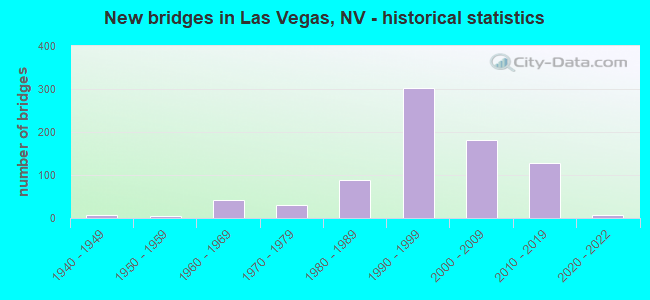
- New bridges - historical statistics
- 11930-1939
- 61940-1949
- 41950-1959
- 431960-1969
- 301970-1979
- 891980-1989
- 3021990-1999
- 1822000-2009
- 1292010-2019
- 72020-2022

- Reconstructed bridges - Historical Statistics
- 11940-1949
- 01950-1959
- 21960-1969
- 01970-1979
- 01980-1989
- 31990-1999
- 152000-2009
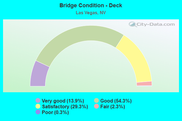
- Bridge Condition - Deck
- 13.9%Very good
- 54.3%Good
- 29.3%Satisfactory
- 2.3%Fair
- 0.3%Poor
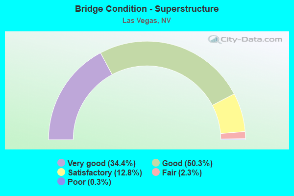
- Bridge Condition - Superstructure
- 34.4%Very good
- 50.3%Good
- 12.8%Satisfactory
- 2.3%Fair
- 0.3%Poor
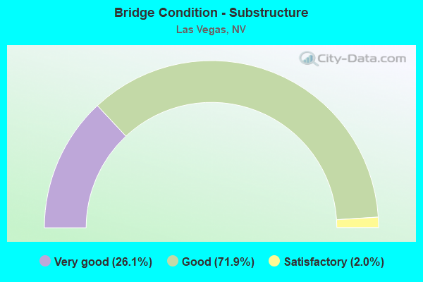
- Bridge Condition - Substructure
- 26.1%Very good
- 71.9%Good
- 2.0%Satisfactory
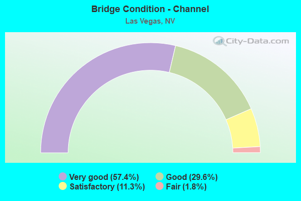
- Bridge Condition - Channel
- 57.4%Very good
- 29.6%Good
- 11.3%Satisfactory
- 1.8%Fair
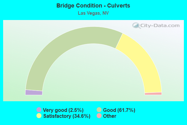
- Bridge Condition - Culverts
- 2.5%Very good
- 61.7%Good
- 34.6%Satisfactory
- 1.3%Fair
- 0.4%Poor
Find on map >> Show street view
Structure Number: H1339, Location: N. OF SPAGHETTI BOWL (Lat: 36.178217, Lng: -115.149367), Route carried "on" structure: Interstate 15, Year Built: 2014, Status: Open, Structure Length: 3.11m (10.20ft), Average Daily Traffic: 117,000 (year 2017), Truck Traffic: 25%, Average Future Daily Traffic: 145,000 (year 2040), Design Load: HL 93, Features Intersected: F STREET
Minimum Vertical Clearance: 30+ m (98+ ft), Kilometerpoint: 69.669, Lanes on structure: 7, Lanes under structure: 2, Base Highway Network: Yes, Owner: State Highway Agency, Approaching Roadway Width: 37.8m (124.0ft), Skew: 33 degrees, Material/Design: Prestressed concrete, Design/Construction: Box Beam or Girders - Single/Spread, Number Of Spans In Main Unit: 1, Length of Maximum Span: 28.3m (92.8ft), Curb-To-Curb Width: 45.6m (149.6ft), Out-to-Out Width: 46.9m (153.9ft)
Condition: Deck: Good, Superstructure: Very good, Substructure: Good, Operating Rating: 64.9 metric tons, Method Used To Determine Operating Rating: Load and Resistance Factor (LRFR), Inventory Rating: 49.9 metric tons, Method Used To Determine Inventory Rating: Load and Resistance Factor (LRFR), Structural Evaluation: Better than present minimum criteria, Deck Geometry: Superior to present desirable criteria, Underclear: Equal to present minimum criteria, Approach Roadway Alignment: Equal to present desirable criteria, Designated Inspection Frequency: Every 48 months, Inspection Date: Febuary 2021, Deck Structure Type: Concrete Cast-file-Place, Wearing Surface/Protective System: Wearing Surface: Monolithic Concrete
Find on map >> Show street view
Structure Number: H1339R, Location: LAS VEGAS (Lat: 36.178153, Lng: -115.148850), Route carried "on" structure: Ramp Interstate 15, Year Built: 2010, Status: Open, Structure Length: 15.10m (49.54ft), Average Daily Traffic: 80,000 (year 2017), Truck Traffic: 3%, Average Future Daily Traffic: 12,500 (year 2040), Design Load: HS 20+Mod, Features Intersected: F - D STREET CONNECTOR
Minimum Vertical Clearance: 30+ m (98+ ft), Kilometerpoint: 0.000, Lanes on structure: 1, Lanes under structure: 2, Base Highway Network: Yes, Owner: State Highway Agency, Approaching Roadway Width: 7.9m (25.9ft), Material/Design: Prestressed concrete continuous, Design/Construction: Box Beam or Girders - Single/Spread, Number Of Spans In Main Unit: 4, Length of Maximum Span: 43.0m (141.1ft), Curb-To-Curb Width: 7.9m (25.9ft), Out-to-Out Width: 8.8m (28.9ft)
Condition: Deck: Good, Superstructure: Good, Substructure: Good, Operating Rating: 89.4 metric tons, Method Used To Determine Operating Rating: Load Factor (LF), Inventory Rating: 49.6 metric tons, Method Used To Determine Inventory Rating: Load Factor (LF), Structural Evaluation: Better than present minimum criteria, Deck Geometry: Equal to present desirable criteria, Underclear: High priority of corrective action, Approach Roadway Alignment: Equal to present desirable criteria, Designated Inspection Frequency: Every 24 months, Inspection Date: Febuary 2020, Deck Structure Type: Concrete Cast-file-Place, Wearing Surface/Protective System: Wearing Surface: Monolithic Concrete
Find on map >> Show street view
Structure Number: H1412, Location: EAST SIDE OF LAS VEGAS (Lat: 36.166778, Lng: -115.098222), Route carried "on" structure: Interstate 515, Year Built: 1982, Status: Open, Structure Length: 4.97m (16.31ft), Average Daily Traffic: 153,000 (year 2017), Truck Traffic: 5%, Average Future Daily Traffic: 316,422 (year 2040), Design Load: HS 20+Mod, Features Intersected: PECOS DR
Minimum Vertical Clearance: 30+ m (98+ ft), Kilometerpoint: 122.521, Lanes on structure: 6, Lanes under structure: 6, Base Highway Network: Yes, Owner: State Highway Agency, Approaching Roadway Width: 35.4m (116.1ft), Skew: 32 degrees, Material/Design: Prestressed concrete, Design/Construction: Box Beam or Girders - Multiple, Number Of Spans In Main Unit: 1, Length of Maximum Span: 49.1m (161.1ft), Curb-To-Curb Width: 35.2m (115.5ft), Out-to-Out Width: 37.0m (121.4ft)
Condition: Deck: Satisfactory, Superstructure: Satisfactory, Substructure: Good, Inventory Rating: 58.4 metric tons, Method Used To Determine Inventory Rating: Load Factor (LF), Structural Evaluation: Equal to present minimum criteria, Deck Geometry: Superior to present desirable criteria, Underclear: Somewhat better than minimum adequacy, Approach Roadway Alignment: Equal to present desirable criteria, Designated Inspection Frequency: Every 48 months, Inspection Date: December 2021, Deck Structure Type: Concrete Cast-file-Place, Wearing Surface/Protective System: Wearing Surface: Monolithic Concrete
Find on map >> Show street view
Structure Number: H1441, Location: LAS VEGAS (Lat: 36.167858, Lng: -115.111694), Route carried "on" structure: Interstate 515, Year Built: 1984, Status: Open, Structure Length: 3.35m (10.99ft), Average Daily Traffic: 153,000 (year 2017), Truck Traffic: 5%, Average Future Daily Traffic: 316,422 (year 2040), Design Load: HS 20+Mod, Features Intersected: 28TH STREET
Minimum Vertical Clearance: 30+ m (98+ ft), Kilometerpoint: 123.736, Lanes on structure: 8, Lanes under structure: 2, Base Highway Network: Yes, Owner: State Highway Agency, Approaching Roadway Width: 42.1m (138.1ft), Skew: 30 degrees, Material/Design: Prestressed concrete, Design/Construction: Box Beam or Girders - Multiple, Number Of Spans In Main Unit: 1, Length of Maximum Span: 30.5m (100.1ft), Curb-To-Curb Width: 42.5m (139.4ft), Out-to-Out Width: 44.2m (145.0ft)
Condition: Deck: Satisfactory, Superstructure: Satisfactory, Substructure: Good, Inventory Rating: 55.8 metric tons, Method Used To Determine Inventory Rating: Load Factor (LF), Structural Evaluation: Equal to present minimum criteria, Deck Geometry: Superior to present desirable criteria, Underclear: Meets minimum limits, Approach Roadway Alignment: Equal to present desirable criteria, Designated Inspection Frequency: Every 48 months, Inspection Date: December 2021, Deck Structure Type: Concrete Cast-file-Place, Wearing Surface/Protective System: Wearing Surface: Monolithic Concrete
Find on map >> Show street view
Structure Number: H1442, Location: LAS VEGAS (Lat: 36.167694, Lng: -115.105544), Route carried "on" structure: Interstate 515, Year Built: 1984, Status: Open, Structure Length: 4.79m (15.72ft), Average Daily Traffic: 153,000 (year 2017), Truck Traffic: 5%, Average Future Daily Traffic: 316,422 (year 2040), Design Load: HS 20+Mod, Features Intersected: MOJAVE ROAD
Minimum Vertical Clearance: 30+ m (98+ ft), Kilometerpoint: 123.190, Lanes on structure: 6, Lanes under structure: 4, Base Highway Network: Yes, Owner: State Highway Agency, Approaching Roadway Width: 35.4m (116.1ft), Skew: 30 degrees, Material/Design: Prestressed concrete, Design/Construction: Box Beam or Girders - Single/Spread, Number Of Spans In Main Unit: 1, Length of Maximum Span: 47.2m (154.9ft), Curb-To-Curb Width: 35.4m (116.1ft), Out-to-Out Width: 37.2m (122.0ft)
Condition: Deck: Satisfactory, Superstructure: Good, Substructure: Good, Inventory Rating: 79.6 metric tons, Method Used To Determine Inventory Rating: Load Factor (LF), Structural Evaluation: Better than present minimum criteria, Deck Geometry: Superior to present desirable criteria, Underclear: Meets minimum limits, Approach Roadway Alignment: Equal to present desirable criteria, Designated Inspection Frequency: Every 48 months, Inspection Date: December 2021, Deck Structure Type: Concrete Cast-file-Place, Wearing Surface/Protective System: Wearing Surface: Monolithic Concrete
Find on map >> Show street view
Structure Number: H1443, Location: EAST LAS VEGAS (Lat: 36.166142, Lng: -115.096542), Route carried "on" structure: Interstate 515, Year Built: 1982, Status: Open, Structure Length: 9.17m (30.09ft), Average Daily Traffic: 133,000 (year 2017), Truck Traffic: 5%, Average Future Daily Traffic: 275,060 (year 2040), Design Load: HS 20+Mod, Features Intersected: STEWART AVE
Minimum Vertical Clearance: 30+ m (98+ ft), Kilometerpoint: 122.381, Lanes on structure: 6, Lanes under structure: 4, Base Highway Network: Yes, Owner: State Highway Agency, Approaching Roadway Width: 35.4m (116.1ft), Skew: 35 degrees, Material/Design: Steel continuous, Design/Construction: Stringer/Multi-beam, Number Of Spans In Main Unit: 2, Length of Maximum Span: 45.7m (149.9ft), Curb-To-Curb Width: 35.2m (115.5ft), Out-to-Out Width: 37.0m (121.4ft)
Condition: Deck: Satisfactory, Superstructure: Good, Substructure: Good, Inventory Rating: 58.4 metric tons, Method Used To Determine Inventory Rating: Load Factor (LF), Structural Evaluation: Better than present minimum criteria, Deck Geometry: Superior to present desirable criteria, Underclear: Better than present minimum criteria, Approach Roadway Alignment: Equal to present desirable criteria, Designated Inspection Frequency: Every 24 months, Inspection Date: December 2021, Deck Structure Type: Concrete Cast-file-Place, Wearing Surface/Protective System: Wearing Surface: Monolithic Concrete
Find on map >> Show street view
Structure Number: H1445, Location: LAS VEGAS (Lat: 36.151839, Lng: -115.091500), Route carried "on" structure: Interstate 515, Year Built: 1986, Status: Open, Structure Length: 4.45m (14.60ft), Average Daily Traffic: 131,000 (year 2017), Truck Traffic: 5%, Average Future Daily Traffic: 270,923 (year 2040), Design Load: HS 20+Mod, Features Intersected: WYOMING AVENUE
Minimum Vertical Clearance: 30+ m (98+ ft), Kilometerpoint: 120.607, Lanes on structure: 9, Lanes under structure: 4, Base Highway Network: Yes, Owner: State Highway Agency, Approaching Roadway Width: 46.3m (151.9ft), Skew: 30 degrees, Material/Design: Prestressed concrete, Design/Construction: Box Beam or Girders - Multiple, Number Of Spans In Main Unit: 1, Length of Maximum Span: 43.9m (144.0ft), Curb-To-Curb Width: 46.3m (151.9ft), Out-to-Out Width: 48.0m (157.5ft)
Condition: Deck: Satisfactory, Superstructure: Good, Substructure: Good, Inventory Rating: 86.8 metric tons, Method Used To Determine Inventory Rating: Load Factor (LF), Structural Evaluation: Better than present minimum criteria, Deck Geometry: Superior to present desirable criteria, Underclear: Somewhat better than minimum adequacy, Approach Roadway Alignment: Equal to present desirable criteria, Designated Inspection Frequency: Every 48 months, Inspection Date: December 2021, Deck Structure Type: Concrete Cast-file-Place, Wearing Surface/Protective System: Wearing Surface: Monolithic Concrete
Find on map >> Show street view
Structure Number: H1446, Location: LAS VEGAS (Lat: 36.146203, Lng: -115.091369), Route carried "on" structure: Interstate 515, Year Built: 1986, Status: Open, Structure Length: 5.91m (19.39ft), Average Daily Traffic: 139,000 (year 2017), Truck Traffic: 5%, Average Future Daily Traffic: 287,468 (year 2040), Design Load: HS 20+Mod, Features Intersected: SAHARA AVENUE
Minimum Vertical Clearance: 30+ m (98+ ft), Kilometerpoint: 119.983, Lanes on structure: 8, Lanes under structure: 6, Base Highway Network: Yes, Owner: State Highway Agency, Approaching Roadway Width: 42.7m (140.1ft), Skew: 32 degrees, Material/Design: Prestressed concrete continuous, Design/Construction: Box Beam or Girders - Multiple, Number Of Spans In Main Unit: 3, Length of Maximum Span: 37.8m (124.0ft), Curb-To-Curb Width: 42.7m (140.1ft), Out-to-Out Width: 44.3m (145.3ft)
Condition: Deck: Satisfactory, Superstructure: Good, Substructure: Good, Inventory Rating: 59.7 metric tons, Method Used To Determine Inventory Rating: Load Factor (LF), Structural Evaluation: Better than present minimum criteria, Deck Geometry: Superior to present desirable criteria, Underclear: High priority of corrective action, Approach Roadway Alignment: Equal to present desirable criteria, Designated Inspection Frequency: Every 48 months, Inspection Date: December 2021, Deck Structure Type: Concrete Cast-file-Place, Wearing Surface/Protective System: Wearing Surface: Monolithic Concrete
Find on map >> Show street view
Structure Number: H145, Location: LAS VEGAS (Lat: 36.129611, Lng: -115.088897), Route carried "on" structure: Interstate 515, Year Built: 1981, Status: Open, Structure Length: 5.15m (16.90ft), Average Daily Traffic: 127,000 (year 2017), Truck Traffic: 7%, Average Future Daily Traffic: 262,651 (year 2040), Design Load: HS 20+Mod, Features Intersected: SR590 DESERT INN RD
Minimum Vertical Clearance: 30+ m (98+ ft), Kilometerpoint: 118.126, Lanes on structure: 8, Lanes under structure: 6, Base Highway Network: Yes, Owner: State Highway Agency, Approaching Roadway Width: 45.1m (148.0ft), Skew: 31 degrees, Material/Design: Steel, Design/Construction: Box Beam or Girders - Multiple, Number Of Spans In Main Unit: 1, Length of Maximum Span: 50.0m (164.0ft), Curb-To-Curb Width: 42.7m (140.1ft), Out-to-Out Width: 44.3m (145.3ft)
Condition: Deck: Poor, Superstructure: Satisfactory, Substructure: Good, Inventory Rating: 58.4 metric tons, Method Used To Determine Inventory Rating: Load Factor (LF), Structural Evaluation: Equal to present minimum criteria, Deck Geometry: Superior to present desirable criteria, Underclear: Superior to present desirable criteria, Approach Roadway Alignment: Equal to present desirable criteria, Designated Inspection Frequency: Every 24 months, Inspection Date: November 2020, Bridge Improvement Cost: $2,242,000, Roadway Improvement Cost: $224,000, Total Project Cost: $3,363,000, Deck Structure Type: Concrete Cast-file-Place, Wearing Surface/Protective System: Wearing Surface: Monolithic Concrete
Find on map >> Show street view
Structure Number: H1451, Location: LAS VEGAS (Lat: 36.122303, Lng: -115.083656), Route carried "on" structure: US 515, Year Built: 1981, Status: Open, Structure Length: 4.69m (15.39ft), Average Daily Traffic: 143,000 (year 2017), Truck Traffic: 7%, Average Future Daily Traffic: 295,000 (year 2040), Design Load: HS 20+Mod, Features Intersected: TWAIN AVENUE
Minimum Vertical Clearance: 30+ m (98+ ft), Kilometerpoint: 117.180, Lanes on structure: 8, Lanes under structure: 2, Base Highway Network: Yes, Owner: State Highway Agency, Approaching Roadway Width: 45.1m (148.0ft), Skew: 31 degrees, Material/Design: Prestressed concrete, Design/Construction: Box Beam or Girders - Multiple, Number Of Spans In Main Unit: 1, Length of Maximum Span: 46.3m (151.9ft), Curb-To-Curb Width: 42.7m (140.1ft), Out-to-Out Width: 44.3m (145.3ft)
Condition: Deck: Satisfactory, Superstructure: Good, Substructure: Good, Inventory Rating: 68.8 metric tons, Method Used To Determine Inventory Rating: Load Factor (LF), Structural Evaluation: Better than present minimum criteria, Deck Geometry: Superior to present desirable criteria, Underclear: Superior to present desirable criteria, Approach Roadway Alignment: Equal to present desirable criteria, Length Of Structure Improvement: 5.61m (18.41ft), Designated Inspection Frequency: Every 48 months, Inspection Date: December 2021, Bridge Improvement Cost: $2,044,000, Roadway Improvement Cost: $204,000, Total Project Cost: $3,066,000, Deck Structure Type: Concrete Cast-file-Place, Wearing Surface/Protective System: Wearing Surface: Monolithic Concrete
Find on map >> Show street view
Structure Number: H1454, Location: LAS VEGAS (Lat: 36.091994, Lng: -115.073092), Route carried "on" structure: US 515, Year Built: 1987, Status: Open, Structure Length: 5.46m (17.91ft), Average Daily Traffic: 110,000 (year 2017), Truck Traffic: 7%, Average Future Daily Traffic: 227,493 (year 2040), Design Load: HS 20+Mod, Features Intersected: FAU 611/MOUNTAIN VISTA
Minimum Vertical Clearance: 30+ m (98+ ft), Kilometerpoint: 113.505, Lanes on structure: 6, Lanes under structure: 4, Base Highway Network: Yes, Owner: State Highway Agency, Approaching Roadway Width: 34.7m (113.8ft), Skew: 33 degrees, Material/Design: Prestressed concrete, Design/Construction: Box Beam or Girders - Multiple, Number Of Spans In Main Unit: 1, Length of Maximum Span: 53.3m (174.9ft), Curb-To-Curb Width: 35.4m (116.1ft), Out-to-Out Width: 36.9m (121.1ft)
Condition: Deck: Satisfactory, Superstructure: Satisfactory, Substructure: Good, Inventory Rating: 77.6 metric tons, Method Used To Determine Inventory Rating: Load Factor (LF), Structural Evaluation: Equal to present minimum criteria, Deck Geometry: Superior to present desirable criteria, Underclear: Better than present minimum criteria, Approach Roadway Alignment: Equal to present desirable criteria, Length Of Structure Improvement: 6.40m (21.00ft), Designated Inspection Frequency: Every 48 months, Inspection Date: December 2021, Bridge Improvement Cost: $1,906,000, Roadway Improvement Cost: $191,000, Total Project Cost: $2,859,000, Deck Structure Type: Concrete Cast-file-Place, Wearing Surface/Protective System: Wearing Surface: Monolithic Concrete
Find on map >> Show street view
Structure Number: H1457, Location: LAS VEGAS (Lat: 36.118622, Lng: -115.082894), Route carried "on" structure: Interstate 515, Year Built: 1986, Status: Open, Structure Length: 4.24m (13.91ft), Average Daily Traffic: 143,000 (year 2017), Truck Traffic: 7%, Average Future Daily Traffic: 295,000 (year 2040), Design Load: HS 20+Mod, Features Intersected: VIKING RD
Minimum Vertical Clearance: 30+ m (98+ ft), Kilometerpoint: 0.000, Lanes on structure: 9, Lanes under structure: 2, Base Highway Network: Yes, Owner: State Highway Agency, Approaching Roadway Width: 49.4m (162.1ft), Skew: 30 degrees, Material/Design: Prestressed concrete, Design/Construction: Box Beam or Girders - Multiple, Number Of Spans In Main Unit: 1, Length of Maximum Span: 41.8m (137.1ft), Curb-To-Curb Width: 49.4m (162.1ft), Out-to-Out Width: 53.3m (174.9ft)
Condition: Deck: Satisfactory, Superstructure: Good, Substructure: Good, Inventory Rating: 81.9 metric tons, Method Used To Determine Inventory Rating: Load Factor (LF), Structural Evaluation: Better than present minimum criteria, Deck Geometry: Superior to present desirable criteria, Underclear: Superior to present desirable criteria, Approach Roadway Alignment: Equal to present desirable criteria, Designated Inspection Frequency: Every 48 months, Inspection Date: December 2021, Deck Structure Type: Concrete Cast-file-Place, Wearing Surface/Protective System: Wearing Surface: Monolithic Concrete
Find on map >> Show street view
Structure Number: H1458, Location: LAS VEGAS (Lat: 36.107658, Lng: -115.082444), Route carried "on" structure: City street 515, Year Built: 1987, Status: Open, Structure Length: 6.49m (21.29ft), Average Daily Traffic: 7,900 (year 2017), Truck Traffic: 3%, Average Future Daily Traffic: 208,000 (year 2040), Design Load: HS 20+Mod, Features Intersected: I 515, US95, US93, Facility Carried by Structure: HARMON AVENUE
Minimum Vertical Clearance: 30+ m (98+ ft), Kilometerpoint: 115.525, Lanes on structure: 3, Lanes under structure: 8, Owner: State Highway Agency, Approaching Roadway Width: 20.4m (66.9ft), Material/Design: Prestressed concrete continuous, Design/Construction: Box Beam or Girders - Multiple, Number Of Spans In Main Unit: 2, Length of Maximum Span: 34.1m (111.9ft), Curb or Sidewalk Widths: Left: 2.2m (7.2ft), Right: 2.2m (7.2ft), Curb-To-Curb Width: 20.4m (66.9ft), Out-to-Out Width: 25.5m (83.7ft)
Condition: Deck: Good, Superstructure: Very good, Substructure: Very good, Inventory Rating: 62.7 metric tons, Method Used To Determine Inventory Rating: Load Factor (LF), Structural Evaluation: Equal to present desirable criteria, Deck Geometry: Superior to present desirable criteria, Underclear: Equal to present minimum criteria, Approach Roadway Alignment: Equal to present desirable criteria, Designated Inspection Frequency: Every 48 months, Inspection Date: November 2021, Deck Structure Type: Concrete Cast-file-Place, Wearing Surface/Protective System: Wearing Surface: Monolithic Concrete
Find on map >> Show street view
Structure Number: H1744, Location: LAS VEGAS (Lat: 36.114328, Lng: -115.183433), Route carried "on" structure: State highway 592, Year Built: 1985, Status: Open, Structure Length: 4.94m (16.21ft), Average Daily Traffic: 78,000 (year 2017), Truck Traffic: 2%, Average Future Daily Traffic: 88,000 (year 2040), Design Load: HS 20+Mod, Features Intersected: DEAN MARTIN
Minimum Vertical Clearance: 30+ m (98+ ft), Kilometerpoint: 5.274, Lanes on structure: 8, Lanes under structure: 5, Owner: State Highway Agency, Approaching Roadway Width: 29.9m (98.1ft), Skew: 30 degrees, Material/Design: Prestressed concrete, Design/Construction: Box Beam or Girders - Multiple, Number Of Spans In Main Unit: 1, Length of Maximum Span: 48.2m (158.1ft), Curb or Sidewalk Widths: Left: 1.8m (5.9ft), Right: 0.0m, Curb-To-Curb Width: 42.5m (139.4ft), Out-to-Out Width: 44.4m (145.7ft)
Condition: Deck: Satisfactory, Superstructure: Good, Substructure: Good, Inventory Rating: 76.4 metric tons, Method Used To Determine Inventory Rating: Load Factor (LF), Structural Evaluation: Better than present minimum criteria, Deck Geometry: Superior to present desirable criteria, Underclear: High priority of corrective action, Approach Roadway Alignment: Equal to present desirable criteria, Designated Inspection Frequency: Every 24 months, Inspection Date: October 2020, Deck Structure Type: Concrete Cast-file-Place, Wearing Surface/Protective System: Wearing Surface: Monolithic Concrete
Find on map >> Show street view
Structure Number: H1804, Location: LAS VEGAS (Lat: 36.080506, Lng: -115.044586), Route carried "on" structure: City street , Year Built: 1987, Status: Open, Structure Length: 6.52m (21.39ft), Average Daily Traffic: 17,500 (year 2017), Truck Traffic: 3%, Average Future Daily Traffic: 36,192 (year 2040), Design Load: HS 20+Mod, Features Intersected: I 515, US95, US93, Facility Carried by Structure: STEPHANIE STREET
Minimum Vertical Clearance: 30+ m (98+ ft), Kilometerpoint: 110.549, Lanes on structure: 3, Lanes under structure: 8, Owner: State Highway Agency, Approaching Roadway Width: 13.7m (44.9ft), Skew: 1 degrees, Material/Design: Prestressed concrete continuous, Design/Construction: Box Beam or Girders - Multiple, Number Of Spans In Main Unit: 2, Length of Maximum Span: 33.8m (110.9ft), Curb or Sidewalk Widths: Left: 1.5m (4.9ft), Right: 0.0m, Curb-To-Curb Width: 13.1m (43.0ft), Out-to-Out Width: 15.5m (50.9ft)
Condition: Deck: Satisfactory, Superstructure: Good, Substructure: Good, Operating Rating: 62.9 metric tons, Method Used To Determine Operating Rating: Load Factor (LF), Inventory Rating: 37.8 metric tons, Method Used To Determine Inventory Rating: Load Factor (LF), Structural Evaluation: Better than present minimum criteria, Deck Geometry: Meets minimum limits, Underclear: Somewhat better than minimum adequacy, Approach Roadway Alignment: Equal to present desirable criteria, Designated Inspection Frequency: Every 24 months, Inspection Date: November 2021, Deck Structure Type: Concrete Cast-file-Place, Wearing Surface/Protective System: Wearing Surface: Monolithic Concrete
Find on map >> Show street view
Structure Number: H1815, Location: MCCARRAN AIRPORT L V (Lat: 36.092353, Lng: -115.147933), Route carried "on" structure: City street , Year Built: 1985, Status: Open, Structure Length: 6.31m (20.70ft), Average Daily Traffic: 34,430 (year 2017), Truck Traffic: 3%, Average Future Daily Traffic: 71,205 (year 2040), Design Load: HS 20, Features Intersected: KITTY HAWK DR, Facility Carried by Structure: AIRPORT ENTRANCE
Minimum Vertical Clearance: 30+ m (98+ ft), Kilometerpoint: 0.000, Lanes on structure: 3, Lanes under structure: 7, Owner: Local Agency, Approaching Roadway Width: 15.2m (49.9ft), Skew: 9 degrees, Material/Design: Concrete continuous, Design/Construction: Box Beam or Girders - Multiple, Number Of Spans In Main Unit: 2, Length of Maximum Span: 33.5m (109.9ft), Curb-To-Curb Width: 15.0m (49.2ft), Out-to-Out Width: 15.9m (52.2ft)
Condition: Deck: Satisfactory, Superstructure: Satisfactory, Substructure: Good, Operating Rating: 73.5 metric tons, Method Used To Determine Operating Rating: Load Factor (LF), Inventory Rating: 44.1 metric tons, Method Used To Determine Inventory Rating: Load Factor (LF), Structural Evaluation: Equal to present minimum criteria, Deck Geometry: Equal to present minimum criteria, Underclear: Equal to present minimum criteria, Approach Roadway Alignment: Equal to present desirable criteria, Designated Inspection Frequency: Every 24 months, Inspection Date: January 2021, Deck Structure Type: Concrete Cast-file-Place, Wearing Surface/Protective System: Wearing Surface: Monolithic Concrete
Find on map >> Show street view
Structure Number: H1816, Location: MCCARRAN AIRPORT L V (Lat: 36.091408, Lng: -115.146889), Route carried "on" structure: City street , Year Built: 1985, Status: Open, Structure Length: 10.36m (33.99ft), Average Daily Traffic: 39,000 (year 2017), Truck Traffic: 3%, Average Future Daily Traffic: 80,657 (year 2040), Design Load: HS 20, Features Intersected: PARADISE RD, Facility Carried by Structure: SWENSON ST
Minimum Vertical Clearance: 30+ m (98+ ft), Kilometerpoint: 0.000, Lanes on structure: 2, Lanes under structure: 4, Base Highway Network: Yes, Owner: Local Agency, Approaching Roadway Width: 14.6m (47.9ft), Skew: 9 degrees, Material/Design: Concrete continuous, Design/Construction: Box Beam or Girders - Multiple, Number Of Spans In Main Unit: 3, Length of Maximum Span: 38.1m (125.0ft), Curb-To-Curb Width: 14.6m (47.9ft), Out-to-Out Width: 15.5m (50.9ft)
Condition: Deck: Satisfactory, Superstructure: Satisfactory, Substructure: Good, Operating Rating: 32.7 metric tons, Method Used To Determine Operating Rating: Load Factor (LF), Inventory Rating: 18.2 metric tons, Method Used To Determine Inventory Rating: Load Factor (LF), Structural Evaluation: Meets minimum limits, Deck Geometry: Superior to present desirable criteria, Underclear: High priority of replacement, Approach Roadway Alignment: Equal to present desirable criteria, Length Of Structure Improvement: 11.28m (37.01ft), Designated Inspection Frequency: Every 24 months, Inspection Date: January 2021, Bridge Improvement Cost: $1,433,000, Roadway Improvement Cost: $143,000, Total Project Cost: $2,150,000, Deck Structure Type: Concrete Cast-file-Place, Wearing Surface/Protective System: Wearing Surface: Monolithic Concrete
Find on map >> Show street view
Structure Number: H1817, Location: MCCARRAN AIRPORT L V (Lat: 36.090767, Lng: -115.148286), Route carried "on" structure: ServiceOther road , Year Built: 1985, Status: Open, Structure Length: 8.96m (29.40ft), Average Daily Traffic: 27,500 (year 2017), Truck Traffic: 1%, Average Future Daily Traffic: 56,873 (year 2040), Design Load: HS 20, Features Intersected: AIRPORT SERVICE DR, Facility Carried by Structure: AIRPORT SERVICE DR
Minimum Vertical Clearance: 30+ m (98+ ft), Kilometerpoint: 0.000, Lanes on structure: 1, Lanes under structure: 3, Owner: Local Agency, Approaching Roadway Width: 6.7m (22.0ft), Material/Design: Concrete continuous, Design/Construction: Box Beam or Girders - Multiple, Number Of Spans In Main Unit: 4, Length of Maximum Span: 24.4m (80.1ft), Curb-To-Curb Width: 6.7m (22.0ft), Out-to-Out Width: 7.6m (24.9ft)
Condition: Deck: Satisfactory, Superstructure: Good, Substructure: Good, Operating Rating: 67.8 metric tons, Method Used To Determine Operating Rating: Load Factor (LF), Inventory Rating: 41.5 metric tons, Method Used To Determine Inventory Rating: Load Factor (LF), Structural Evaluation: Better than present minimum criteria, Deck Geometry: High priority of replacement, Underclear: High priority of corrective action, Approach Roadway Alignment: Equal to present desirable criteria, Designated Inspection Frequency: Every 48 months, Inspection Date: Febuary 2021, Deck Structure Type: Concrete Cast-file-Place, Wearing Surface/Protective System: Wearing Surface: Monolithic Concrete
Find on map >> Show street view
Structure Number: H1818, Location: MCCARRAN AIRPORT L V (Lat: 36.085019, Lng: -115.145569), Route carried "on" structure: Business Other road , Year Built: 1985, Status: Open, Structure Length: 5.94m (19.49ft), Average Daily Traffic: 15,000 (year 2017), Truck Traffic: 1%, Average Future Daily Traffic: 31,022 (year 2040), Design Load: HS 20, Features Intersected: EXIT TO PARADISE RD, Facility Carried by Structure: EXIT TO SWENSON ST
Minimum Vertical Clearance: 30+ m (98+ ft), Kilometerpoint: 0.000, Lanes on structure: 4, Lanes under structure: 5, Owner: Local Agency, Approaching Roadway Width: 18.6m (61.0ft), Skew: 1 degrees, Material/Design: Concrete continuous, Design/Construction: Box Beam or Girders - Multiple, Number Of Spans In Main Unit: 3, Length of Maximum Span: 24.4m (80.1ft), Curb-To-Curb Width: 18.6m (61.0ft), Out-to-Out Width: 23.9m (78.4ft)
Condition: Deck: Satisfactory, Superstructure: Good, Substructure: Good, Operating Rating: 40.5 metric tons, Method Used To Determine Operating Rating: Load Factor (LF), Inventory Rating: 31.9 metric tons, Method Used To Determine Inventory Rating: Load Factor (LF), Structural Evaluation: Better than present minimum criteria, Deck Geometry: Equal to present minimum criteria, Underclear: High priority of corrective action, Approach Roadway Alignment: Equal to present desirable criteria, Designated Inspection Frequency: Every 24 months, Inspection Date: Febuary 2021, Deck Structure Type: Concrete Cast-file-Place, Wearing Surface/Protective System: Wearing Surface: Monolithic Concrete
Find on map >> Show street view
Structure Number: H1890E, Location: LAS VEGAS (Lat: 36.178150, Lng: -115.291442), Route carried "on" structure: County highway , Year Built: 1990, Status: Open, Structure Length: 1.12m (3.67ft), Average Daily Traffic: 26,250 (year 2017), Truck Traffic: 3%, Average Future Daily Traffic: 40,000 (year 2040), Design Load: HS 20+Mod, Features Intersected: GOLF CART PATH, Facility Carried by Structure: SUMMERLIN PKWY, EB
Minimum Vertical Clearance: 30+ m (98+ ft), Kilometerpoint: 0.000, Lanes on structure: 3, Owner: City or Municipal Highway Agency, Approaching Roadway Width: 15.5m (50.9ft), Skew: 4 degrees, Material/Design: Concrete, Design/Construction: Slab, Number Of Spans In Main Unit: 1, Length of Maximum Span: 6.9m (22.6ft), Curb-To-Curb Width: 15.5m (50.9ft), Out-to-Out Width: 16.5m (54.1ft)
Condition: Deck: Satisfactory, Superstructure: Satisfactory, Substructure: Good, Operating Rating: 54.5 metric tons, Method Used To Determine Operating Rating: Load Factor (LF), Inventory Rating: 32.7 metric tons, Method Used To Determine Inventory Rating: Load Factor (LF), Structural Evaluation: Equal to present minimum criteria, Deck Geometry: Equal to present minimum criteria, Approach Roadway Alignment: Equal to present desirable criteria, Designated Inspection Frequency: Every 48 months, Inspection Date: January 2020, Deck Structure Type: Concrete Cast-file-Place, Wearing Surface/Protective System: Wearing Surface: Bituminous, Deck Protection: Epoxy Coated Reinforcing
Find on map >> Show street view
Structure Number: H1890W, Location: LAS VEGAS (Lat: 36.178375, Lng: -115.291183), Route carried "on" structure: County highway , Year Built: 1990, Status: Open, Structure Length: 1.12m (3.67ft), Average Daily Traffic: 26,250 (year 2017), Truck Traffic: 3%, Average Future Daily Traffic: 40,000 (year 2040), Design Load: HS 20+Mod, Features Intersected: GOLF CART PATH, Facility Carried by Structure: SUMMERLIN PKWY, WB
Minimum Vertical Clearance: 30+ m (98+ ft), Kilometerpoint: 0.000, Lanes on structure: 3, Owner: City or Municipal Highway Agency, Approaching Roadway Width: 15.5m (50.9ft), Skew: 4 degrees, Material/Design: Concrete, Design/Construction: Slab, Number Of Spans In Main Unit: 1, Length of Maximum Span: 6.9m (22.6ft), Curb-To-Curb Width: 15.5m (50.9ft), Out-to-Out Width: 16.5m (54.1ft)
Condition: Deck: Satisfactory, Superstructure: Satisfactory, Substructure: Good, Operating Rating: 54.5 metric tons, Method Used To Determine Operating Rating: Load Factor (LF), Inventory Rating: 32.7 metric tons, Method Used To Determine Inventory Rating: Load Factor (LF), Structural Evaluation: Equal to present minimum criteria, Deck Geometry: Equal to present minimum criteria, Approach Roadway Alignment: Equal to present desirable criteria, Designated Inspection Frequency: Every 48 months, Inspection Date: January 2020, Deck Structure Type: Concrete Cast-file-Place, Wearing Surface/Protective System: Wearing Surface: Monolithic Concrete, Deck Protection: Epoxy Coated Reinforcing
Find on map >> Show street view
Structure Number: H1901N, Location: LAS VEGAS (Lat: 36.120403, Lng: -115.180436), Route carried "on" structure: Interstate 15, Year Built: 1993, Status: Open, Structure Length: 6.34m (20.80ft), Average Daily Traffic: 118,000 (year 2017), Truck Traffic: 7%, Average Future Daily Traffic: 333,000 (year 2040), Design Load: HS 20+Mod, Features Intersected: INDUSTRIAL RD
Minimum Vertical Clearance: 30+ m (98+ ft), Kilometerpoint: 0.000, Lanes on structure: 6, Lanes under structure: 6, Base Highway Network: Yes, Owner: State Highway Agency, Approaching Roadway Width: 25.0m (82.0ft), Skew: 3 degrees, Material/Design: Prestressed concrete, Design/Construction: Box Beam or Girders - Multiple, Number Of Spans In Main Unit: 1, Length of Maximum Span: 62.2m (204.1ft), Curb-To-Curb Width: 25.0m (82.0ft), Out-to-Out Width: 25.9m (85.0ft)
Condition: Deck: Good, Superstructure: Very good, Substructure: Good, Inventory Rating: 78.0 metric tons, Method Used To Determine Inventory Rating: Load Factor (LF), Structural Evaluation: Better than present minimum criteria, Deck Geometry: Meets minimum limits, Underclear: High priority of corrective action, Approach Roadway Alignment: Equal to present desirable criteria, Designated Inspection Frequency: Every 24 months, Inspection Date: January 2021, Deck Structure Type: Concrete Cast-file-Place, Wearing Surface/Protective System: Wearing Surface: Monolithic Concrete
Find on map >> Show street view
Structure Number: H1901R, Location: LAS VEGAS (Lat: 36.120639, Lng: -115.180161), Route carried "on" structure: Ramp Interstate , Year Built: 1999, Status: Open, Structure Length: 6.22m (20.41ft), Average Daily Traffic: 25,500 (year 2017), Average Future Daily Traffic: 333,000 (year 2040), Design Load: HS 20+Mod, Features Intersected: INDUSTRIAL RD, Facility Carried by Structure: RMP 15N TO SPR MTN
Minimum Vertical Clearance: 30+ m (98+ ft), Kilometerpoint: 0.000, Lanes on structure: 2, Lanes under structure: 6, Base Highway Network: Yes, Owner: State Highway Agency, Approaching Roadway Width: 12.1m (39.7ft), Skew: 3 degrees, Material/Design: Prestressed concrete, Design/Construction: Box Beam or Girders - Multiple, Number Of Spans In Main Unit: 1, Length of Maximum Span: 62.1m (203.7ft), Curb-To-Curb Width: 12.1m (39.7ft), Out-to-Out Width: 13.1m (43.0ft)
Condition: Deck: Good, Superstructure: Very good, Substructure: Good, Inventory Rating: 60.7 metric tons, Method Used To Determine Inventory Rating: Load Factor (LF), Structural Evaluation: Better than present minimum criteria, Deck Geometry: Superior to present desirable criteria, Underclear: Meets minimum limits, Approach Roadway Alignment: Equal to present desirable criteria, Designated Inspection Frequency: Every 24 months, Inspection Date: January 2021, Deck Structure Type: Concrete Cast-file-Place, Wearing Surface/Protective System: Wearing Surface: Monolithic Concrete
Find on map >> Show street view
Structure Number: H1901S, Location: LAS VEGAS (Lat: 36.120294, Lng: -115.180769), Route carried "on" structure: Interstate 15, Year Built: 1993, Status: Open, Structure Length: 6.34m (20.80ft), Average Daily Traffic: 118,000 (year 2017), Truck Traffic: 7%, Average Future Daily Traffic: 333,000 (year 2040), Design Load: HS 20+Mod, Features Intersected: INDUSTRIAL RD
Minimum Vertical Clearance: 30+ m (98+ ft), Kilometerpoint: 0.000, Lanes on structure: 6, Lanes under structure: 6, Base Highway Network: Yes, Owner: State Highway Agency, Approaching Roadway Width: 25.6m (84.0ft), Skew: 3 degrees, Material/Design: Prestressed concrete, Design/Construction: Box Beam or Girders - Multiple, Number Of Spans In Main Unit: 1, Length of Maximum Span: 62.2m (204.1ft), Curb-To-Curb Width: 25.6m (84.0ft), Out-to-Out Width: 26.5m (86.9ft)
Condition: Deck: Good, Superstructure: Good, Substructure: Good, Inventory Rating: 78.0 metric tons, Method Used To Determine Inventory Rating: Load Factor (LF), Structural Evaluation: Better than present minimum criteria, Deck Geometry: Meets minimum limits, Underclear: Meets minimum limits, Approach Roadway Alignment: Equal to present desirable criteria, Length Of Structure Improvement: 7.38m (24.21ft), Designated Inspection Frequency: Every 24 months, Inspection Date: January 2021, Bridge Improvement Cost: $1,604,000, Roadway Improvement Cost: $160,000, Total Project Cost: $2,405,000, Deck Structure Type: Concrete Cast-file-Place, Wearing Surface/Protective System: Wearing Surface: Monolithic Concrete
Find on map >> Show street view
Structure Number: H1941, Location: LAS VEGAS (Lat: 36.086036, Lng: -115.182747), Route carried "on" structure: Alternate County highway 594, Year Built: 1993, Status: Open, Structure Length: 5.30m (17.39ft), Average Daily Traffic: 26,000 (year 2017), Truck Traffic: 8%, Average Future Daily Traffic: 12,500 (year 2040), Design Load: HS 20, Features Intersected: INDUSTRIAL RD
Minimum Vertical Clearance: 30+ m (98+ ft), Kilometerpoint: 0.283, Lanes on structure: 7, Lanes under structure: 4, Owner: State Highway Agency, Approaching Roadway Width: 31.1m (102.0ft), Skew: 1 degrees, Material/Design: Prestressed concrete, Design/Construction: Box Beam or Girders - Multiple, Number Of Spans In Main Unit: 1, Length of Maximum Span: 53.0m (173.9ft), Curb or Sidewalk Widths: Left: 1.8m (5.9ft), Right: 1.8m (5.9ft), Curb-To-Curb Width: 31.1m (102.0ft), Out-to-Out Width: 38.4m (126.0ft)
Condition: Deck: Good, Superstructure: Good, Substructure: Good, Inventory Rating: 77.4 metric tons, Method Used To Determine Inventory Rating: Load Factor (LF), Structural Evaluation: Better than present minimum criteria, Deck Geometry: Better than present minimum criteria, Underclear: Somewhat better than minimum adequacy, Approach Roadway Alignment: Equal to present desirable criteria, Designated Inspection Frequency: Every 24 months, Inspection Date: October 2020, Deck Structure Type: Concrete Cast-file-Place, Wearing Surface/Protective System: Wearing Surface: Monolithic Concrete
Find on map >> Show street view
Structure Number: H1967N, Location: LAS VEGAS (Lat: 36.027828, Lng: -115.129692), Route carried "on" structure: Interstate 215, Year Built: 1996, Status: Open, Structure Length: 6.77m (22.21ft), Average Daily Traffic: 77,000 (year 2017), Truck Traffic: 1%, Average Future Daily Traffic: 159,245 (year 2040), Design Load: HS 20+Mod, Features Intersected: PEBBLE RD
Minimum Vertical Clearance: 30+ m (98+ ft), Kilometerpoint: 0.000, Lanes on structure: 3, Lanes under structure: 4, Base Highway Network: Yes, Owner: County Highway Agency, Approaching Roadway Width: 20.0m (65.6ft), Skew: 3 degrees, Material/Design: Prestressed concrete continuous, Design/Construction: Box Beam or Girders - Single/Spread, Number Of Spans In Main Unit: 2, Length of Maximum Span: 33.5m (109.9ft), Curb-To-Curb Width: 20.0m (65.6ft), Out-to-Out Width: 20.2m (66.3ft)
Condition: Deck: Good, Superstructure: Very good, Substructure: Good, Operating Rating: 88.4 metric tons, Method Used To Determine Operating Rating: Load Factor (LF), Inventory Rating: 52.9 metric tons, Method Used To Determine Inventory Rating: Load Factor (LF), Structural Evaluation: Better than present minimum criteria, Deck Geometry: Superior to present desirable criteria, Underclear: Superior to present desirable criteria, Approach Roadway Alignment: Equal to present desirable criteria, Designated Inspection Frequency: Every 24 months, Inspection Date: November 2020, Deck Structure Type: Concrete Cast-file-Place, Wearing Surface/Protective System: Wearing Surface: Monolithic Concrete
Find on map >> Show street view
Structure Number: H1967S, Location: LAS VEGAS (Lat: 36.027839, Lng: -115.130067), Route carried "on" structure: Interstate 215, Year Built: 1996, Status: Open, Structure Length: 6.74m (22.11ft), Average Daily Traffic: 77,000 (year 2017), Truck Traffic: 1%, Average Future Daily Traffic: 159,245 (year 2040), Design Load: HS 20+Mod, Features Intersected: PEBBLE RD
Minimum Vertical Clearance: 30+ m (98+ ft), Kilometerpoint: 0.000, Lanes on structure: 3, Lanes under structure: 4, Base Highway Network: Yes, Owner: County Highway Agency, Approaching Roadway Width: 19.9m (65.3ft), Skew: 3 degrees, Material/Design: Prestressed concrete continuous, Design/Construction: Box Beam or Girders - Single/Spread, Number Of Spans In Main Unit: 2, Length of Maximum Span: 33.2m (108.9ft), Curb-To-Curb Width: 19.9m (65.3ft), Out-to-Out Width: 20.7m (67.9ft)
Condition: Deck: Good, Superstructure: Very good, Substructure: Good, Operating Rating: 90.5 metric tons, Method Used To Determine Operating Rating: Load Factor (LF), Inventory Rating: 54.5 metric tons, Method Used To Determine Inventory Rating: Load Factor (LF), Structural Evaluation: Better than present minimum criteria, Deck Geometry: Superior to present desirable criteria, Underclear: Superior to present desirable criteria, Approach Roadway Alignment: Equal to present desirable criteria, Designated Inspection Frequency: Every 24 months, Inspection Date: November 2020, Deck Structure Type: Concrete Cast-file-Place, Wearing Surface/Protective System: Wearing Surface: Monolithic Concrete
Find on map >> Show street view
Structure Number: H1968, Location: LAS VEGAS (Lat: 36.035289, Lng: -115.133147), Route carried "on" structure: City street , Year Built: 1996, Status: Open, Structure Length: 8.17m (26.80ft), Average Daily Traffic: 1,100 (year 2017), Truck Traffic: 1%, Average Future Daily Traffic: 2,275 (year 2040), Design Load: HS 20+Mod, Features Intersected: I 215 BELTWAY, Facility Carried by Structure: WIGWAM AV
Minimum Vertical Clearance: 30+ m (98+ ft), Kilometerpoint: 0.000, Lanes on structure: 4, Lanes under structure: 6, Owner: County Highway Agency, Approaching Roadway Width: 21.0m (68.9ft), Skew: 1 degrees, Material/Design: Prestressed concrete continuous, Design/Construction: Box Beam or Girders - Single/Spread, Number Of Spans In Main Unit: 2, Length of Maximum Span: 39.9m (130.9ft), Curb or Sidewalk Widths: Left: 1.7m (5.6ft), Right: 1.7m (5.6ft), Curb-To-Curb Width: 21.0m (68.9ft), Out-to-Out Width: 25.0m (82.0ft)
Condition: Deck: Good, Superstructure: Good, Substructure: Good, Inventory Rating: 68.6 metric tons, Method Used To Determine Inventory Rating: Load Factor (LF), Structural Evaluation: Better than present minimum criteria, Deck Geometry: Superior to present desirable criteria, Underclear: Superior to present desirable criteria, Approach Roadway Alignment: Equal to present desirable criteria, Designated Inspection Frequency: Every 24 months, Inspection Date: October 2020, Deck Structure Type: Concrete Cast-file-Place, Wearing Surface/Protective System: Wearing Surface: Monolithic Concrete
Find on map >> Show street view
Structure Number: H1971N, Location: LAS VEGAS (Lat: 36.049967, Lng: -115.135486), Route carried "on" structure: County highway 215, Year Built: 1995, Year Reconstructed: 2013, Status: Open, Structure Length: 5.00m (16.40ft), Average Daily Traffic: 101,000 (year 2017), Truck Traffic: 3%, Average Future Daily Traffic: 208,880 (year 2040), Design Load: HS 20+Mod, Features Intersected: ROBINDALE ROAD
Minimum Vertical Clearance: 30+ m (98+ ft), Kilometerpoint: 0.000, Lanes on structure: 5, Lanes under structure: 3, Base Highway Network: Yes, Owner: County Highway Agency, Approaching Roadway Width: 25.6m (84.0ft), Skew: 2 degrees, Material/Design: Prestressed concrete, Design/Construction: Box Beam or Girders - Single/Spread, Number Of Spans In Main Unit: 1, Length of Maximum Span: 49.7m (163.1ft), Curb-To-Curb Width: 25.6m (84.0ft), Out-to-Out Width: 26.5m (86.9ft)
Condition: Deck: Good, Superstructure: Good, Substructure: Very good, Inventory Rating: 61.3 metric tons, Method Used To Determine Inventory Rating: Load Factor (LF), Structural Evaluation: Better than present minimum criteria, Deck Geometry: Better than present minimum criteria, Underclear: Meets minimum limits, Approach Roadway Alignment: Equal to present desirable criteria, Designated Inspection Frequency: Every 48 months, Inspection Date: November 2021, Deck Structure Type: Concrete Cast-file-Place, Wearing Surface/Protective System: Wearing Surface: Bituminous
Find on map >> Show street view
Structure Number: H1971S, Location: LAS VEGAS (Lat: 36.049944, Lng: -115.135772), Route carried "on" structure: County highway 215, Year Built: 1995, Year Reconstructed: 2013, Status: Open, Structure Length: 5.00m (16.40ft), Average Daily Traffic: 101,000 (year 2017), Truck Traffic: 3%, Average Future Daily Traffic: 208,880 (year 2040), Design Load: HS 20+Mod, Features Intersected: ROBINDALE ROAD
Minimum Vertical Clearance: 30+ m (98+ ft), Kilometerpoint: 0.000, Lanes on structure: 5, Lanes under structure: 3, Base Highway Network: Yes, Owner: County Highway Agency, Approaching Roadway Width: 29.3m (96.1ft), Skew: 2 degrees, Material/Design: Prestressed concrete, Design/Construction: Box Beam or Girders - Single/Spread, Number Of Spans In Main Unit: 1, Length of Maximum Span: 49.7m (163.1ft), Curb-To-Curb Width: 29.3m (96.1ft), Out-to-Out Width: 30.2m (99.1ft)
Condition: Deck: Good, Superstructure: Good, Substructure: Very good, Inventory Rating: 56.4 metric tons, Method Used To Determine Inventory Rating: Load Factor (LF), Structural Evaluation: Better than present minimum criteria, Deck Geometry: Superior to present desirable criteria, Underclear: Meets minimum limits, Approach Roadway Alignment: Equal to present desirable criteria, Designated Inspection Frequency: Every 48 months, Inspection Date: November 2021, Deck Structure Type: Concrete Cast-file-Place, Wearing Surface/Protective System: Wearing Surface: Bituminous
Find on map >> Show street view
Structure Number: H1974, Location: LAS VEGAS (Lat: 36.067528, Lng: -115.147692), Route carried "on" structure: County highway 171, Year Built: 1994, Status: Open, Structure Length: 7.01m (23.00ft), Average Daily Traffic: 32,808 (year 2017), Truck Traffic: 5%, Average Future Daily Traffic: 162,000 (year 2040), Design Load: HS 20+Mod, Features Intersected: SR 171 AIRPORT CONNECT, Facility Carried by Structure: PILOT RD
Minimum Vertical Clearance: 30+ m (98+ ft), Kilometerpoint: 0.483, Lanes on structure: 4, Lanes under structure: 7, Owner: State Highway Agency, Approaching Roadway Width: 14.9m (48.9ft), Skew: 1 degrees, Material/Design: Prestressed concrete continuous, Design/Construction: Box Beam or Girders - Multiple, Number Of Spans In Main Unit: 3, Length of Maximum Span: 28.7m (94.2ft), Curb or Sidewalk Widths: Left: 1.7m (5.6ft), Right: 1.7m (5.6ft), Curb-To-Curb Width: 14.9m (48.9ft), Out-to-Out Width: 18.9m (62.0ft)
Condition: Deck: Satisfactory, Superstructure: Good, Substructure: Good, Operating Rating: 70.8 metric tons, Method Used To Determine Operating Rating: Load Factor (LF), Inventory Rating: 42.4 metric tons, Method Used To Determine Inventory Rating: Load Factor (LF), Structural Evaluation: Better than present minimum criteria, Deck Geometry: High priority of replacement, Underclear: Equal to present minimum criteria, Approach Roadway Alignment: Equal to present desirable criteria, Length Of Structure Improvement: 7.71m (25.30ft), Designated Inspection Frequency: Every 48 months, Inspection Date: November 2020, Bridge Improvement Cost: $874,000, Roadway Improvement Cost: $87,000, Total Project Cost: $1,311,000, Deck Structure Type: Concrete Cast-file-Place, Wearing Surface/Protective System: Wearing Surface: Monolithic Concrete
Find on map >> Show street view
Structure Number: H1976, Location: LAS VEGAS (Lat: 36.070111, Lng: -115.146728), Route carried "on" structure: City street , Year Built: 1994, Status: Open, Structure Length: 7.38m (24.21ft), Average Daily Traffic: 1,100 (year 2017), Truck Traffic: 5%, Average Future Daily Traffic: 2,650 (year 2040), Design Load: HS 20+Mod, Features Intersected: SR 171 AIRPORT CONNECT, Facility Carried by Structure: GRIER DR
Minimum Vertical Clearance: 30+ m (98+ ft), Kilometerpoint: 0.808, Lanes on structure: 2, Lanes under structure: 6, Owner: State Highway Agency, Approaching Roadway Width: 14.9m (48.9ft), Skew: 1 degrees, Material/Design: Prestressed concrete continuous, Design/Construction: Box Beam or Girders - Multiple, Number Of Spans In Main Unit: 3, Length of Maximum Span: 32.3m (106.0ft), Curb or Sidewalk Widths: Left: 1.7m (5.6ft), Right: 1.7m (5.6ft), Curb-To-Curb Width: 14.9m (48.9ft), Out-to-Out Width: 18.9m (62.0ft)
Condition: Deck: Satisfactory, Superstructure: Good, Substructure: Good, Operating Rating: 69.2 metric tons, Method Used To Determine Operating Rating: Load Factor (LF), Inventory Rating: 41.5 metric tons, Method Used To Determine Inventory Rating: Load Factor (LF), Structural Evaluation: Better than present minimum criteria, Deck Geometry: Superior to present desirable criteria, Underclear: Equal to present minimum criteria, Approach Roadway Alignment: Equal to present desirable criteria, Designated Inspection Frequency: Every 24 months, Inspection Date: November 2020, Deck Structure Type: Concrete Cast-file-Place, Wearing Surface/Protective System: Wearing Surface: Monolithic Concrete
Find on map >> Show street view
Structure Number: H1979, Location: LAS VEGAS (Lat: 36.063622, Lng: -115.163375), Route carried "on" structure: City street , Year Built: 1994, Status: Open, Structure Length: 8.29m (27.20ft), Average Daily Traffic: 8,300 (year 2017), Truck Traffic: 8%, Average Future Daily Traffic: 17,165 (year 2040), Design Load: HS 20+Mod, Features Intersected: I 215, Facility Carried by Structure: GILLESPIE ST
Minimum Vertical Clearance: 30+ m (98+ ft), Kilometerpoint: 4.039, Lanes on structure: 6, Lanes under structure: 11, Owner: County Highway Agency, Approaching Roadway Width: 25.6m (84.0ft), Skew: 20 degrees, Material/Design: Prestressed concrete continuous, Design/Construction: Box Beam or Girders - Multiple, Number Of Spans In Main Unit: 2, Length of Maximum Span: 41.5m (136.2ft), Curb or Sidewalk Widths: Left: 1.7m (5.6ft), Right: 1.7m (5.6ft), Curb-To-Curb Width: 25.6m (84.0ft), Out-to-Out Width: 29.6m (97.1ft)
Condition: Deck: Satisfactory, Superstructure: Good, Substructure: Good, Inventory Rating: 62.0 metric tons, Method Used To Determine Inventory Rating: Load Factor (LF), Structural Evaluation: Better than present minimum criteria, Deck Geometry: Somewhat better than minimum adequacy, Underclear: Better than present minimum criteria, Approach Roadway Alignment: Equal to present desirable criteria, Designated Inspection Frequency: Every 24 months, Inspection Date: October 2020, Deck Structure Type: Concrete Cast-file-Place, Wearing Surface/Protective System: Wearing Surface: Monolithic Concrete
Find on map >> Show street view
Structure Number: H1992, Location: SOUTH EAST OF LAS VEGAS (Lat: 36.066517, Lng: -115.190139), Route carried "on" structure: County highway , Year Built: 1998, Status: Open, Structure Length: 7.99m (26.21ft), Average Daily Traffic: 16,000 (year 2017), Truck Traffic: 3%, Average Future Daily Traffic: 33,090 (year 2040), Design Load: HS 20, Features Intersected: I 215, Facility Carried by Structure: VALLEY VIEW
Minimum Vertical Clearance: 30+ m (98+ ft), Kilometerpoint: 0.000, Lanes on structure: 6, Lanes under structure: 10, Owner: County Highway Agency, Approaching Roadway Width: 27.1m (88.9ft), Skew: 21 degrees, Material/Design: Prestressed concrete continuous, Design/Construction: Box Beam or Girders - Multiple, Number Of Spans In Main Unit: 2, Length of Maximum Span: 39.9m (130.9ft), Curb or Sidewalk Widths: Left: 1.7m (5.6ft), Right: 1.7m (5.6ft), Curb-To-Curb Width: 27.1m (88.9ft), Out-to-Out Width: 31.2m (102.4ft)
Condition: Deck: Good, Superstructure: Good, Substructure: Good, Inventory Rating: 57.8 metric tons, Method Used To Determine Inventory Rating: Load Factor (LF), Structural Evaluation: Better than present minimum criteria, Deck Geometry: Better than present minimum criteria, Underclear: Equal to present minimum criteria, Approach Roadway Alignment: Equal to present desirable criteria, Designated Inspection Frequency: Every 24 months, Inspection Date: December 2020, Deck Structure Type: Concrete Cast-file-Place, Wearing Surface/Protective System: Wearing Surface: Monolithic Concrete
Find on map >> Show street view
Structure Number: H2011, Location: LAS VEGAS (Lat: 36.130458, Lng: -115.180581), Route carried "on" structure: State highway 590, Year Built: 1995, Status: Open, Structure Length: 14.33m (47.01ft), Average Daily Traffic: 34,000 (year 2017), Truck Traffic: 6%, Average Future Daily Traffic: 329,000 (year 2040), Design Load: HS 20+Mod, Features Intersected: I 15, Facility Carried by Structure: DESERT INN RD
Minimum Vertical Clearance: 30+ m (98+ ft), Kilometerpoint: 0.000, Lanes on structure: 7, Lanes under structure: 15, Owner: State Highway Agency, Approaching Roadway Width: 29.8m (97.8ft), Skew: 33 degrees, Material/Design: Prestressed concrete, Design/Construction: Box Beam or Girders - Multiple, Number Of Spans In Main Unit: 3, Length of Maximum Span: 58.8m (192.9ft), Curb-To-Curb Width: 33.5m (109.9ft), Out-to-Out Width: 34.4m (112.9ft)
Condition: Deck: Satisfactory, Superstructure: Satisfactory, Substructure: Satisfactory, Operating Rating: 54.5 metric tons, Method Used To Determine Operating Rating: Load Factor (LF), Inventory Rating: 32.7 metric tons, Method Used To Determine Inventory Rating: Load Factor (LF), Structural Evaluation: Equal to present minimum criteria, Deck Geometry: Superior to present desirable criteria, Underclear: Equal to present minimum criteria, Approach Roadway Alignment: Equal to present desirable criteria, Designated Inspection Frequency: Every 24 months, Inspection Date: December 2020, Deck Structure Type: Concrete Cast-file-Place, Wearing Surface/Protective System: Wearing Surface: Monolithic Concrete
Find on map >> Show street view
Structure Number: H2013, Location: LAS VEGAS (Lat: 36.131100, Lng: -115.165586), Route carried "on" structure: State highway 604, Year Built: 1996, Status: Open, Structure Length: 3.29m (10.79ft), Average Daily Traffic: 44,500 (year 2017), Truck Traffic: 3%, Average Future Daily Traffic: 92,031 (year 2040), Design Load: HS 20+Mod, Features Intersected: DESERT INN RD, Facility Carried by Structure: LAS VEGAS BLVD
Minimum Vertical Clearance: 30+ m (98+ ft), Kilometerpoint: 0.000, Lanes on structure: 7, Lanes under structure: 6, Owner: County Highway Agency, Approaching Roadway Width: 37.8m (124.0ft), Skew: 20 degrees, Material/Design: Prestressed concrete continuous, Design/Construction: Box Beam or Girders - Multiple, Number Of Spans In Main Unit: 2, Length of Maximum Span: 15.8m (51.8ft), Curb or Sidewalk Widths: Left: 16.5m (54.1ft), Right: 1.8m (5.9ft), Curb-To-Curb Width: 37.8m (124.0ft), Out-to-Out Width: 115.1m (377.6ft)
Condition: Deck: Good, Superstructure: Good, Substructure: Good, Operating Rating: 89.4 metric tons, Method Used To Determine Operating Rating: Load Factor (LF), Inventory Rating: 53.5 metric tons, Method Used To Determine Inventory Rating: Load Factor (LF), Structural Evaluation: Better than present minimum criteria, Deck Geometry: Superior to present desirable criteria, Underclear: Equal to present minimum criteria, Approach Roadway Alignment: Equal to present desirable criteria, Designated Inspection Frequency: Every 48 months, Inspection Date: January 2020, Deck Structure Type: Concrete Cast-file-Place, Wearing Surface/Protective System: Wearing Surface: Bituminous
Find on map >> Show street view
Structure Number: H2013W, Location: LAS VEGAS (Lat: 36.131331, Lng: -115.166419), Route carried "on" structure: City street , Year Built: 1996, Status: Open, Structure Length: 3.29m (10.79ft), Average Daily Traffic: 1,375 (year 2017), Truck Traffic: 3%, Average Future Daily Traffic: 2,844 (year 2040), Design Load: HS 20+Mod, Features Intersected: DESERT INN RD, Facility Carried by Structure: CATHEDRAL WY
Minimum Vertical Clearance: 30+ m (98+ ft), Kilometerpoint: 0.000, Lanes on structure: 4, Lanes under structure: 6, Owner: County Highway Agency, Approaching Roadway Width: 15.2m (49.9ft), Material/Design: Prestressed concrete continuous, Design/Construction: Box Beam or Girders - Multiple, Number Of Spans In Main Unit: 2, Length of Maximum Span: 15.8m (51.8ft), Curb or Sidewalk Widths: Left: 3.2m (10.5ft), Right: 2.2m (7.2ft), Curb-To-Curb Width: 15.2m (49.9ft), Out-to-Out Width: 59.4m (194.9ft)
Condition: Deck: Good, Superstructure: Good, Substructure: Good, Inventory Rating: 67.2 metric tons, Method Used To Determine Inventory Rating: Load Factor (LF), Structural Evaluation: Better than present minimum criteria, Deck Geometry: High priority of corrective action, Underclear: Equal to present minimum criteria, Approach Roadway Alignment: Equal to present desirable criteria, Designated Inspection Frequency: Every 48 months, Inspection Date: January 2020, Deck Structure Type: Concrete Cast-file-Place, Wearing Surface/Protective System: Wearing Surface: Bituminous
Find on map >> Show street view
Structure Number: H2015, Location: LAS VEGAS (Lat: 36.117017, Lng: -115.180214), Route carried "on" structure: Ramp Interstate 15, Year Built: 1999, Status: Open, Structure Length: 15.45m (50.69ft), Average Daily Traffic: 25,500 (year 2017), Average Future Daily Traffic: 333,000 (year 2040), Design Load: HS 20+Mod, Features Intersected: RAMP FLAMINGO TO I 15
Minimum Vertical Clearance: 30+ m (98+ ft), Kilometerpoint: 0.000, Lanes on structure: 2, Lanes under structure: 2, Base Highway Network: Yes, Owner: State Highway Agency, Approaching Roadway Width: 12.1m (39.7ft), Material/Design: Prestressed concrete continuous, Design/Construction: Box Beam or Girders - Multiple, Number Of Spans In Main Unit: 3, Length of Maximum Span: 59.4m (194.9ft), Curb-To-Curb Width: 12.1m (39.7ft), Out-to-Out Width: 13.1m (43.0ft)
Condition: Deck: Satisfactory, Superstructure: Good, Substructure: Good, Operating Rating: 82.9 metric tons, Method Used To Determine Operating Rating: Load Factor (LF), Inventory Rating: 49.6 metric tons, Method Used To Determine Inventory Rating: Load Factor (LF), Structural Evaluation: Better than present minimum criteria, Deck Geometry: Superior to present desirable criteria, Underclear: Somewhat better than minimum adequacy, Approach Roadway Alignment: Equal to present desirable criteria, Designated Inspection Frequency: Every 24 months, Inspection Date: Febuary 2021, Deck Structure Type: Concrete Cast-file-Place, Wearing Surface/Protective System: Wearing Surface: Monolithic Concrete
Find on map >> Show street view
Structure Number: H2040N, Location: LAS VEGAS (Lat: 36.058444, Lng: -115.141106), Route carried "on" structure: County highway 215, Year Built: 1995, Status: Open, Structure Length: 5.64m (18.50ft), Average Daily Traffic: 85,000 (year 2017), Truck Traffic: 3%, Average Future Daily Traffic: 175,790 (year 2040), Design Load: HS 20+Mod, Features Intersected: PARADISE RD
Minimum Vertical Clearance: 30+ m (98+ ft), Kilometerpoint: 0.000, Lanes on structure: 5, Lanes under structure: 4, Base Highway Network: Yes, Owner: County Highway Agency, Approaching Roadway Width: 25.6m (84.0ft), Skew: 5 degrees, Material/Design: Prestressed concrete, Design/Construction: Box Beam or Girders - Multiple, Number Of Spans In Main Unit: 1, Length of Maximum Span: 54.2m (177.8ft), Curb-To-Curb Width: 25.6m (84.0ft), Out-to-Out Width: 26.5m (86.9ft)
Condition: Deck: Good, Superstructure: Very good, Substructure: Good, Operating Rating: 83.5 metric tons, Method Used To Determine Operating Rating: Load Factor (LF), Inventory Rating: 49.9 metric tons, Method Used To Determine Inventory Rating: Load Factor (LF), Structural Evaluation: Better than present minimum criteria, Deck Geometry: Better than present minimum criteria, Underclear: Meets minimum limits, Approach Roadway Alignment: Equal to present desirable criteria, Designated Inspection Frequency: Every 24 months, Inspection Date: October 2020, Deck Structure Type: Concrete Cast-file-Place, Wearing Surface/Protective System: Wearing Surface: Bituminous
Find on map >> Show street view
Structure Number: H2040S, Location: LAS VEGAS (Lat: 36.058144, Lng: -115.141117), Route carried "on" structure: County highway 215, Year Built: 1995, Status: Open, Structure Length: 5.85m (19.19ft), Average Daily Traffic: 87,800 (year 2017), Truck Traffic: 3%, Average Future Daily Traffic: 181,581 (year 2040), Design Load: HS 20+Mod, Features Intersected: PARADISE RD
Minimum Vertical Clearance: 30+ m (98+ ft), Kilometerpoint: 0.000, Lanes on structure: 6, Lanes under structure: 4, Base Highway Network: Yes, Owner: County Highway Agency, Maintenance Responsibility: State Highway Agency, Approaching Roadway Width: 35.7m (117.1ft), Skew: 4 degrees, Material/Design: Prestressed concrete, Design/Construction: Box Beam or Girders - Multiple, Number Of Spans In Main Unit: 1, Length of Maximum Span: 56.7m (186.0ft), Curb-To-Curb Width: 35.7m (117.1ft), Out-to-Out Width: 36.6m (120.1ft)
Condition: Deck: Good, Superstructure: Very good, Substructure: Good, Operating Rating: 83.5 metric tons, Method Used To Determine Operating Rating: Load Factor (LF), Inventory Rating: 49.9 metric tons, Method Used To Determine Inventory Rating: Load Factor (LF), Structural Evaluation: Better than present minimum criteria, Deck Geometry: Superior to present desirable criteria, Underclear: Meets minimum limits, Approach Roadway Alignment: Equal to present desirable criteria, Designated Inspection Frequency: Every 24 months, Inspection Date: October 2020, Deck Structure Type: Concrete Cast-file-Place, Wearing Surface/Protective System: Wearing Surface: Bituminous
Find on map >> Show street view
Structure Number: H2079N, Location: LAS VEGAS (Lat: 36.025836, Lng: -115.127364), Route carried "on" structure: Interstate 215, Year Built: 1996, Status: Open, Structure Length: 5.85m (19.19ft), Average Daily Traffic: 77,000 (year 2017), Truck Traffic: 1%, Average Future Daily Traffic: 159,245 (year 2040), Design Load: HS 20+Mod, Features Intersected: SPENCER STREET
Minimum Vertical Clearance: 30+ m (98+ ft), Kilometerpoint: 0.000, Lanes on structure: 3, Lanes under structure: 4, Base Highway Network: Yes, Owner: County Highway Agency, Approaching Roadway Width: 18.3m (60.0ft), Skew: 3 degrees, Material/Design: Prestressed concrete continuous, Design/Construction: Box Beam or Girders - Single/Spread, Number Of Spans In Main Unit: 2, Length of Maximum Span: 28.7m (94.2ft), Curb-To-Curb Width: 18.3m (60.0ft), Out-to-Out Width: 19.2m (63.0ft)
Condition: Deck: Good, Superstructure: Good, Substructure: Good, Operating Rating: 70.5 metric tons, Method Used To Determine Operating Rating: Load Factor (LF), Inventory Rating: 42.1 metric tons, Method Used To Determine Inventory Rating: Load Factor (LF), Structural Evaluation: Better than present minimum criteria, Deck Geometry: Better than present minimum criteria, Underclear: Meets minimum limits, Approach Roadway Alignment: Equal to present desirable criteria, Designated Inspection Frequency: Every 48 months, Inspection Date: September 2020, Deck Structure Type: Concrete Cast-file-Place, Wearing Surface/Protective System: Wearing Surface: Monolithic Concrete