Bridge Statistics for Las Vegas, Nevada (NV)
Condition, Traffic, Stress, Structural Evaluation, Project Costs
- National Bridge Inventory (NBI) Statistics
- 793Number of bridges
- 12,585ft / 3,836mTotal length
- $111,427,000Total costs
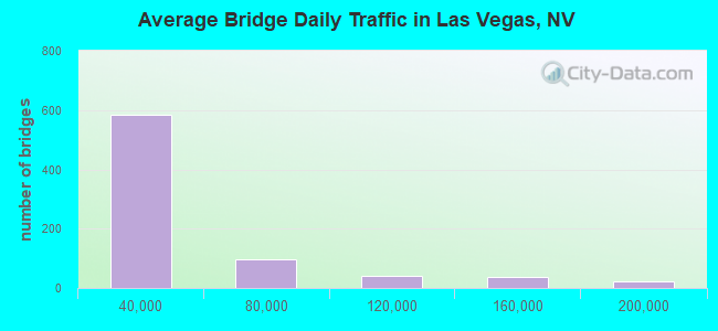
- 28,103,074Total average daily traffic
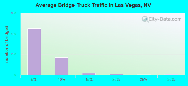
- 1,412,722Total average daily truck traffic
- National Bridge Inventory (NBI) Registered Bridges for Las Vegas
- No street view available for this location
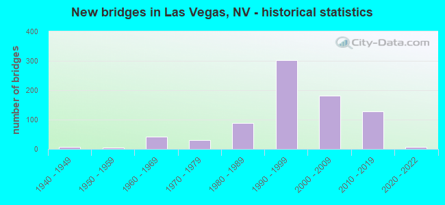
- New bridges - historical statistics
- 11930-1939
- 61940-1949
- 41950-1959
- 431960-1969
- 301970-1979
- 891980-1989
- 3021990-1999
- 1822000-2009
- 1292010-2019
- 72020-2022

- Reconstructed bridges - Historical Statistics
- 11940-1949
- 01950-1959
- 21960-1969
- 01970-1979
- 01980-1989
- 31990-1999
- 152000-2009
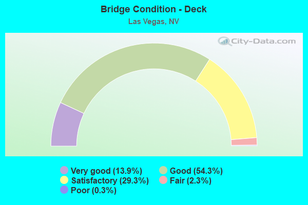
- Bridge Condition - Deck
- 13.9%Very good
- 54.3%Good
- 29.3%Satisfactory
- 2.3%Fair
- 0.3%Poor
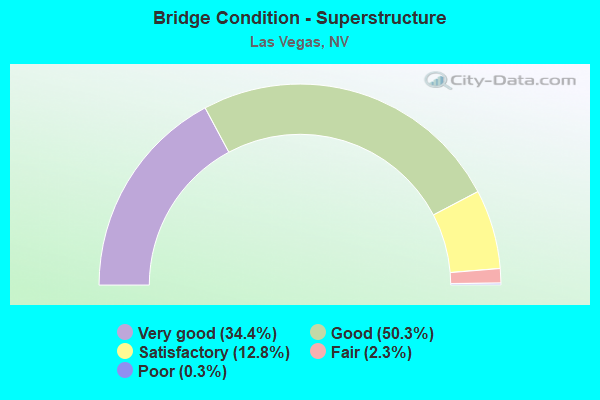
- Bridge Condition - Superstructure
- 34.4%Very good
- 50.3%Good
- 12.8%Satisfactory
- 2.3%Fair
- 0.3%Poor
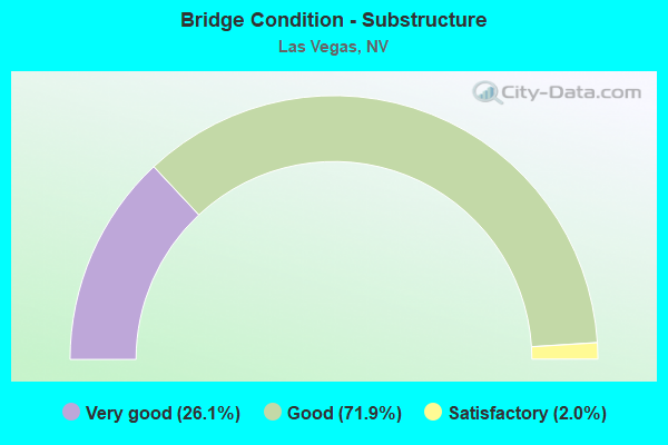
- Bridge Condition - Substructure
- 26.1%Very good
- 71.9%Good
- 2.0%Satisfactory
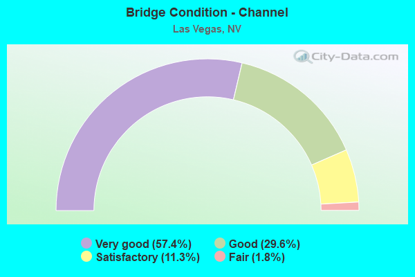
- Bridge Condition - Channel
- 57.4%Very good
- 29.6%Good
- 11.3%Satisfactory
- 1.8%Fair
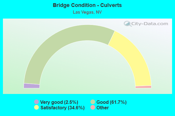
- Bridge Condition - Culverts
- 2.5%Very good
- 61.7%Good
- 34.6%Satisfactory
- 1.3%Fair
- 0.4%Poor
Find on map >> Show street view
Structure Number: H1974, Location: LAS VEGAS (Lat: 36.067528, Lng: -115.147692), Route carried "under" structure: State highway 171, Year Built: 1994, Structure Length: 0. m, Average Daily Traffic: 103,000 (year 2009), Truck Traffic: 3%, Features Intersected: SR 171 AIRPORT CONNECT, Facility Carried by Structure: PILOT RD
Minimum Vertical Clearance: 5.03m (16.50ft), Kilometerpoint: 0.483, Lanes on structure: 4, Lanes under structure: 7, Material/Design: Prestressed concrete continuous, Design/Construction: Box Beam or Girders - Multiple, Length of Maximum Span: 28.7m (94.2ft)
Find on map >> Show street view
Structure Number: H1976, Location: LAS VEGAS (Lat: 36.070111, Lng: -115.146728), Route carried "under" structure: State highway 171, Year Built: 1994, Structure Length: 0. m, Average Daily Traffic: 103,000 (year 2009), Truck Traffic: 3%, Features Intersected: SR 171 AIRPORT CONNECT, Facility Carried by Structure: GRIER DR
Minimum Vertical Clearance: 5.67m (18.60ft), Kilometerpoint: 0.808, Lanes on structure: 2, Lanes under structure: 6, Material/Design: Prestressed concrete continuous, Design/Construction: Box Beam or Girders - Multiple, Length of Maximum Span: 32.3m (106.0ft)
Find on map >> Show street view
Structure Number: H1979, Location: LAS VEGAS (Lat: 36.063622, Lng: -115.163375), Route carried "under" structure: Interstate 215, Year Built: 1994, Structure Length: 0. m, Average Daily Traffic: 184,000 (year 2009), Truck Traffic: 3%, Features Intersected: I 215, Facility Carried by Structure: GILLESPIE ST
Minimum Vertical Clearance: 5.03m (16.50ft), Kilometerpoint: 4.039, Lanes on structure: 6, Lanes under structure: 11, Material/Design: Prestressed concrete continuous, Design/Construction: Box Beam or Girders - Multiple, Length of Maximum Span: 41.5m (136.2ft)
Find on map >> Show street view
Structure Number: H1992, Location: SOUTH EAST OF LAS VEGAS (Lat: 36.066517, Lng: -115.190139), Route carried "under" structure: Interstate 215, Year Built: 1998, Structure Length: 0. m, Average Daily Traffic: 124,000 (year 2009), Truck Traffic: 10%, Features Intersected: I 215, Facility Carried by Structure: VALLEY VIEW
Minimum Vertical Clearance: 5.09m (16.70ft), Kilometerpoint: 0.000, Lanes on structure: 6, Lanes under structure: 10, Material/Design: Prestressed concrete continuous, Design/Construction: Box Beam or Girders - Multiple, Length of Maximum Span: 39.9m (130.9ft)
Find on map >> Show street view
Structure Number: H2011, Location: LAS VEGAS (Lat: 36.130458, Lng: -115.180581), Route carried "under" structure: Interstate 15, Year Built: 1995, Structure Length: 0. m, Average Daily Traffic: 251,000 (year 2009), Truck Traffic: 3%, Features Intersected: I 15, Facility Carried by Structure: DESERT INN RD
Minimum Vertical Clearance: 6.49m (21.29ft), Kilometerpoint: 0.000, Lanes on structure: 7, Lanes under structure: 15, Material/Design: Prestressed concrete, Design/Construction: Box Beam or Girders - Multiple, Length of Maximum Span: 58.8m (192.9ft)
Find on map >> Show street view
Structure Number: H2013, Location: LAS VEGAS (Lat: 36.131100, Lng: -115.165586), Route carried "under" structure: County highway , Year Built: 1996, Structure Length: 0. m, Average Daily Traffic: 2,750 (year 2009), Truck Traffic: 4%, Features Intersected: DESERT INN RD, Facility Carried by Structure: LAS VEGAS BLVD
Minimum Vertical Clearance: 5.06m (16.60ft), Kilometerpoint: 0.000, Lanes on structure: 7, Lanes under structure: 6, Material/Design: Prestressed concrete continuous, Design/Construction: Box Beam or Girders - Multiple, Length of Maximum Span: 15.8m (51.8ft)
Find on map >> Show street view
Structure Number: H2013W, Location: LAS VEGAS (Lat: 36.131331, Lng: -115.166419), Route carried "under" structure: County highway , Year Built: 1996, Structure Length: 0. m, Average Daily Traffic: 2,750 (year 2009), Truck Traffic: 4%, Features Intersected: DESERT INN RD, Facility Carried by Structure: CATHEDRAL WY
Minimum Vertical Clearance: 5.03m (16.50ft), Kilometerpoint: 0.000, Lanes on structure: 4, Lanes under structure: 6, Material/Design: Prestressed concrete continuous, Design/Construction: Box Beam or Girders - Multiple, Length of Maximum Span: 15.8m (51.8ft)
Find on map >> Show street view
Structure Number: H2040N, Location: LAS VEGAS (Lat: 36.058444, Lng: -115.141106), Route carried "under" structure: County highway , Year Built: 1995, Structure Length: 0. m, Average Daily Traffic: 14,000 (year 2009), Truck Traffic: 3%, Features Intersected: PARADISE RD, Facility Carried by Structure: I 215 BELT WAY
Minimum Vertical Clearance: 5.73m (18.80ft), Kilometerpoint: 0.000, Lanes on structure: 5, Lanes under structure: 4, Material/Design: Prestressed concrete, Design/Construction: Box Beam or Girders - Multiple, Length of Maximum Span: 54.2m (177.8ft)
Find on map >> Show street view
Structure Number: H2040S, Location: LAS VEGAS (Lat: 36.058144, Lng: -115.141117), Route carried "under" structure: County highway , Year Built: 1995, Structure Length: 0. m, Average Daily Traffic: 14,000 (year 2009), Truck Traffic: 3%, Features Intersected: PARADISE RD, Facility Carried by Structure: I 215 BELT WAY
Minimum Vertical Clearance: 5.73m (18.80ft), Kilometerpoint: 0.000, Lanes on structure: 6, Lanes under structure: 4, Material/Design: Prestressed concrete, Design/Construction: Box Beam or Girders - Multiple, Length of Maximum Span: 56.7m (186.0ft)
Find on map >> Show street view
Structure Number: H2079N, Location: LAS VEGAS (Lat: 36.025836, Lng: -115.127364), Route carried "under" structure: City street , Year Built: 1996, Structure Length: 0. m, Average Daily Traffic: 14,300 (year 2009), Truck Traffic: 3%, Features Intersected: SPENCER STREET, Facility Carried by Structure: I 215 BELTWAY
Minimum Vertical Clearance: 5.06m (16.60ft), Kilometerpoint: 0.000, Lanes on structure: 3, Lanes under structure: 4, Material/Design: Prestressed concrete continuous, Design/Construction: Box Beam or Girders - Single/Spread, Length of Maximum Span: 28.7m (94.2ft)
Find on map >> Show street view
Structure Number: H2079S, Location: LAS VEGAS (Lat: 36.025525, Lng: -115.127364), Route carried "under" structure: City street , Year Built: 1996, Structure Length: 0. m, Average Daily Traffic: 14,300 (year 2009), Truck Traffic: 3%, Features Intersected: SPENCER STREET, Facility Carried by Structure: I 215 BELTWAY
Minimum Vertical Clearance: 5.06m (16.60ft), Kilometerpoint: 0.000, Lanes on structure: 3, Lanes under structure: 4, Material/Design: Prestressed concrete continuous, Design/Construction: Box Beam or Girders - Single/Spread, Length of Maximum Span: 28.3m (92.8ft)
Find on map >> Show street view
Structure Number: H2092, Location: SOUTH LAS VEGAS (Lat: 36.093478, Lng: -115.180747), Route carried "under" structure: County highway , Year Built: 1999, Structure Length: 0. m, Average Daily Traffic: 8,250 (year 2009), Truck Traffic: 3%, Features Intersected: I 15, Facility Carried by Structure: HACIENDA AVE
Minimum Vertical Clearance: 5.46m (17.91ft), Kilometerpoint: 0.000, Lanes on structure: 4, Lanes under structure: 26, Material/Design: Steel continuous, Design/Construction: Stringer/Multi-beam, Length of Maximum Span: 40.8m (133.9ft)
Find on map >> Show street view
Structure Number: H2092, Location: SOUTH LAS VEGAS (Lat: 36.093478, Lng: -115.180747), Route carried "under" structure: County highway , Year Built: 1999, Structure Length: 0. m, Average Daily Traffic: 1,000 (year 2009), Truck Traffic: 2%, Features Intersected: I 15, Facility Carried by Structure: HACIENDA AVE
Minimum Vertical Clearance: 5.00m (16.40ft), Kilometerpoint: 0.000, Lanes on structure: 4, Lanes under structure: 26, Material/Design: Steel continuous, Design/Construction: Stringer/Multi-beam, Length of Maximum Span: 40.8m (133.9ft)
Find on map >> Show street view
Structure Number: H2148, Location: LV (NEXT TO AIRPORT) (Lat: 36.080086, Lng: -115.143469), Route carried "under" structure: County highway , Year Built: 1997, Structure Length: 0. m, Average Daily Traffic: 5,500 (year 2009), Truck Traffic: 3%, Features Intersected: PARADISE RD, Facility Carried by Structure: SERVICE ROAD
Minimum Vertical Clearance: 4.88m (16.01ft), Kilometerpoint: 0.000, Lanes on structure: 2, Lanes under structure: 7, Material/Design: Prestressed concrete, Design/Construction: Box Beam or Girders - Multiple, Length of Maximum Span: 24.3m (79.7ft)
Find on map >> Show street view
Structure Number: H2263, Location: LAS VEGAS (Lat: 36.108172, Lng: -115.180611), Route carried "under" structure: County highway , Year Built: 2003, Structure Length: 0. m, Average Daily Traffic: 25,000 (year 2009), Truck Traffic: 4%, Features Intersected: I-15, INDUSTRIAL, FSD, Facility Carried by Structure: HARMON AV
Minimum Vertical Clearance: 5.21m (17.09ft), Kilometerpoint: 0.000, Lanes on structure: 6, Lanes under structure: 21, Material/Design: Steel continuous, Design/Construction: Stringer/Multi-beam, Length of Maximum Span: 42.7m (140.1ft)
Find on map >> Show street view
Structure Number: H2263, Location: LAS VEGAS (Lat: 36.108172, Lng: -115.180611), Route carried "under" structure: County highway , Year Built: 2003, Structure Length: 0. m, Average Daily Traffic: 1,000 (year 2009), Truck Traffic: 2%, Features Intersected: I-15, INDUSTRIAL, FSD, Facility Carried by Structure: HARMON AV
Minimum Vertical Clearance: 0.00m, Kilometerpoint: 0.000, Lanes on structure: 6, Lanes under structure: 21, Material/Design: Steel continuous, Design/Construction: Stringer/Multi-beam, Length of Maximum Span: 42.7m (140.1ft)
Find on map >> Show street view
Structure Number: H2311, Location: WEST LAS VEGAS (Lat: 36.109556, Lng: -115.297150), Route carried "under" structure: County highway , Year Built: 2000, Structure Length: 0. m, Average Daily Traffic: 3,850 (year 2009), Features Intersected: CC 215, Facility Carried by Structure: FORT APACHE RD
Minimum Vertical Clearance: 5.94m (19.49ft), Kilometerpoint: 0.000, Lanes on structure: 6, Lanes under structure: 8, Material/Design: Prestressed concrete continuous, Design/Construction: Box Beam or Girders - Multiple, Length of Maximum Span: 72.5m (237.9ft)
Find on map >> Show street view
Structure Number: H2315, Location: WEST OF LAS VEGAS (Lat: 36.118867, Lng: -115.314889), Route carried "under" structure: County highway 215, Year Built: 2000, Structure Length: 0. m, Average Daily Traffic: 3,300 (year 2009), Features Intersected: I 215 WESTERN BELTWAY, Facility Carried by Structure: HUALAPAI WAY
Minimum Vertical Clearance: 5.58m (18.31ft), Kilometerpoint: 0.000, Lanes on structure: 6, Lanes under structure: 6, Material/Design: Prestressed concrete continuous, Design/Construction: Box Beam or Girders - Multiple, Length of Maximum Span: 41.0m (134.5ft)
Find on map >> Show street view
Structure Number: H2317, Location: WESTERN LAS VEGAS (Lat: 36.129636, Lng: -115.334869), Route carried "under" structure: County highway 215, Year Built: 2000, Structure Length: 0. m, Average Daily Traffic: 3,300 (year 2009), Features Intersected: I 215 WESTERN BELTWAY, Facility Carried by Structure: W.DESERT INN ROAD
Minimum Vertical Clearance: 5.12m (16.80ft), Kilometerpoint: 0.000, Lanes on structure: 4, Lanes under structure: 6, Material/Design: Prestressed concrete continuous, Design/Construction: Box Beam or Girders - Multiple, Length of Maximum Span: 39.9m (130.9ft)
Find on map >> Show street view
Structure Number: H2321, Location: N.W. LAS VEGAS (Lat: 36.170050, Lng: -115.337761), Route carried "under" structure: County highway 215, Year Built: 2004, Structure Length: 0. m, Average Daily Traffic: 4,550 (year 2009), Truck Traffic: 3%, Features Intersected: CC 215, Facility Carried by Structure: ALTA DRIVE
Minimum Vertical Clearance: 5.00m (16.40ft), Kilometerpoint: 0.000, Lanes on structure: 4, Lanes under structure: 4, Material/Design: Prestressed concrete continuous, Design/Construction: Box Beam or Girders - Multiple, Length of Maximum Span: 45.4m (149.0ft)
Find on map >> Show street view
Structure Number: H2326, Location: N LAS VEGAS (Lat: 36.232692, Lng: -115.325550), Route carried "under" structure: County highway 215, Year Built: 2003, Structure Length: 0. m, Average Daily Traffic: 12,100 (year 2009), Truck Traffic: 4%, Features Intersected: CC 215, Facility Carried by Structure: W ALEXANDER RD
Minimum Vertical Clearance: 5.06m (16.60ft), Kilometerpoint: 0.000, Lanes on structure: 4, Lanes under structure: 6, Material/Design: Prestressed concrete continuous, Design/Construction: Box Beam or Girders - Single/Spread, Length of Maximum Span: 46.0m (150.9ft)
Find on map >> Show street view
Structure Number: H2331, Location: NORTH LAS VEGAS (Lat: 36.281447, Lng: -115.190739), Route carried "under" structure: County highway 215, Year Built: 2004, Structure Length: 0. m, Average Daily Traffic: 10,000 (year 2009), Truck Traffic: 3%, Features Intersected: CC 215, Facility Carried by Structure: AVIARY WAY
Minimum Vertical Clearance: 5.49m (18.01ft), Kilometerpoint: 0.000, Lanes on structure: 4, Lanes under structure: 4, Material/Design: Prestressed concrete continuous, Design/Construction: Box Beam or Girders - Multiple, Length of Maximum Span: 39.9m (130.9ft)
Find on map >> Show street view
Structure Number: H2338, Location: NW LAS VEGAS (Lat: 36.276069, Lng: -115.267758), Route carried "under" structure: Ramp US 95, Year Built: 2002, Structure Length: 0. m, Average Daily Traffic: 2,530 (year 2009), Truck Traffic: 2%, Features Intersected: RMP R2&R3
Minimum Vertical Clearance: 5.21m (17.09ft), Kilometerpoint: 0.000, Lanes on structure: 1, Lanes under structure: 2, Material/Design: Prestressed concrete, Design/Construction: Box Beam or Girders - Multiple, Length of Maximum Span: 33.5m (109.9ft)
Find on map >> Show street view
Structure Number: H2345, Location: LAS VEGAS (Lat: 36.085947, Lng: -115.178756), Route carried "under" structure: City street , Year Built: 1998, Structure Length: 0. m, Average Daily Traffic: 1,100 (year 2009), Truck Traffic: 3%, Features Intersected: FRANK SINATRA DR, Facility Carried by Structure: SR594 RUSSELL RD
Minimum Vertical Clearance: 5.09m (16.70ft), Kilometerpoint: 0.000, Lanes on structure: 7, Lanes under structure: 4, Material/Design: Prestressed concrete, Design/Construction: Box Beam or Girders - Multiple, Length of Maximum Span: 44.2m (145.0ft)
Find on map >> Show street view
Structure Number: H2346, Location: LAS VEGAS (Lat: 36.100644, Lng: -115.179444), Route carried "under" structure: County highway , Year Built: 2002, Structure Length: 0. m, Average Daily Traffic: 5,000 (year 2009), Truck Traffic: 1%, Features Intersected: FRANK SINATRA DR, Facility Carried by Structure: SR593 TROPICANA AV
Minimum Vertical Clearance: 5.00m (16.40ft), Kilometerpoint: 0.000, Lanes on structure: 10, Lanes under structure: 4, Material/Design: Prestressed concrete, Design/Construction: Box Beam or Girders - Multiple, Length of Maximum Span: 13.4m (44.0ft)
Find on map >> Show street view
Structure Number: H2348, Location: EAST OF PARADISE ROAD (Lat: 36.129428, Lng: -115.152922), Route carried "under" structure: City street , Year Built: 1997, Structure Length: 0. m, Average Daily Traffic: 42,000 (year 2009), Truck Traffic: 2%, Features Intersected: DESERT INN ROAD, Facility Carried by Structure: IN/OUT CONVENTION
Minimum Vertical Clearance: 5.03m (16.50ft), Kilometerpoint: 0.000, Lanes on structure: 4, Lanes under structure: 6, Material/Design: Prestressed concrete continuous, Design/Construction: Box Beam or Girders - Single/Spread, Length of Maximum Span: 16.4m (53.8ft)
Find on map >> Show street view
Structure Number: H2349, Location: 1000' EAST OF PARADISE (Lat: 36.129406, Lng: -115.150392), Route carried "under" structure: City street , Year Built: 1997, Structure Length: 0. m, Average Daily Traffic: 42,000 (year 2009), Truck Traffic: 2%, Features Intersected: DESERT INN ROAD, Facility Carried by Structure: IN/OUT CONVENTION
Minimum Vertical Clearance: 5.79m (19.00ft), Kilometerpoint: 0.000, Lanes on structure: 2, Lanes under structure: 6, Material/Design: Prestressed concrete continuous, Design/Construction: Box Beam or Girders - Multiple, Length of Maximum Span: 16.0m (52.5ft)
Find on map >> Show street view
Structure Number: H235, Location: 1700' E OF PARADISE RD (Lat: 36.129403, Lng: -115.148125), Route carried "under" structure: City street , Year Built: 1997, Structure Length: 0. m, Average Daily Traffic: 42,000 (year 2009), Truck Traffic: 2%, Features Intersected: DESERT INN RD, Facility Carried by Structure: IN/OUT CONVENTION
Minimum Vertical Clearance: 4.82m (15.81ft), Kilometerpoint: 0.000, Lanes on structure: 2, Lanes under structure: 6, Material/Design: Prestressed concrete continuous, Design/Construction: Box Beam or Girders - Multiple, Length of Maximum Span: 16.0m (52.5ft)
Find on map >> Show street view
Structure Number: H2486, Location: NW LAS VEGAS (Lat: 36.276131, Lng: -115.251642), Route carried "under" structure: County highway 215, Year Built: 2002, Structure Length: 0. m, Average Daily Traffic: 3,300 (year 2009), Features Intersected: CC 215, Facility Carried by Structure: TENAYA WY
Minimum Vertical Clearance: 5.18m (16.99ft), Kilometerpoint: 0.000, Lanes on structure: 4, Lanes under structure: 4, Material/Design: Prestressed concrete continuous, Design/Construction: Box Beam or Girders - Multiple, Length of Maximum Span: 39.9m (130.9ft)
Find on map >> Show street view
Structure Number: H2534, Location: SUMMERLIN (Lat: 36.192050, Lng: -115.316025), Route carried "under" structure: County highway , Year Built: 1999, Structure Length: 0. m, Average Daily Traffic: 26,900 (year 2009), Truck Traffic: 2%, Features Intersected: SUMMERLIN PW, Facility Carried by Structure: CRESTDALE LN
Minimum Vertical Clearance: 17.13m (56.20ft), Kilometerpoint: 0.000, Lanes on structure: 4, Lanes under structure: 5, Material/Design: Prestressed concrete continuous, Design/Construction: Box Beam or Girders - Multiple, Length of Maximum Span: 33.5m (109.9ft)
Find on map >> Show street view
Structure Number: H2538, Location: LAS VEGAS (Lat: 36.119986, Lng: -115.181756), Route carried "under" structure: County highway , Year Built: 1999, Structure Length: 0. m, Average Daily Traffic: 15,500 (year 2014), Truck Traffic: 3%, Features Intersected: TWAIN AVENUE, Facility Carried by Structure: RR MAINTENANCE RD
Minimum Vertical Clearance: 5.03m (16.50ft), Kilometerpoint: 0.000, Lanes on structure: 1, Lanes under structure: 7, Material/Design: Steel, Design/Construction: Stringer/Multi-beam, Length of Maximum Span: 21.3m (69.9ft)
Find on map >> Show street view
Structure Number: H2653, Location: NW Las Vegas (Lat: 36.273236, Lng: -115.262647), Route carried "under" structure: US 95, Year Built: 2002, Structure Length: 0. m, Average Daily Traffic: 64,350 (year 2009), Truck Traffic: 3%, Features Intersected: US 95, Facility Carried by Structure: TROPICAL PW
Minimum Vertical Clearance: 6.34m (20.80ft), Kilometerpoint: 0.000, Lanes on structure: 4, Lanes under structure: 4, Material/Design: Prestressed concrete continuous, Design/Construction: Box Beam or Girders - Single/Spread, Length of Maximum Span: 40.7m (133.5ft)
Find on map >> Show street view
Structure Number: H2667, Location: LAS VEGAS (Lat: 36.291828, Lng: -115.279650), Route carried "under" structure: US 95, Year Built: 2006, Structure Length: 0. m, Average Daily Traffic: 40,000 (year 2009), Truck Traffic: 5%, Features Intersected: US95, Facility Carried by Structure: ELKHORN RD
Minimum Vertical Clearance: 6.22m (20.41ft), Kilometerpoint: 0.000, Lanes on structure: 6, Lanes under structure: 10, Material/Design: Prestressed concrete continuous, Design/Construction: Box Beam or Girders - Multiple, Length of Maximum Span: 51.8m (169.9ft)
Find on map >> Show street view
Structure Number: H271, Location: LAS VEGAS (Lat: 36.175547, Lng: -115.169769), Route carried "under" structure: Ramp State highway , Year Built: 2007, Structure Length: 0. m, Average Daily Traffic: 5,000 (year 2009), Truck Traffic: 1%, Features Intersected: RANCHO RAMP TO US95S, Facility Carried by Structure: 95S OFF R TO I15N/
Minimum Vertical Clearance: 5.00m (16.40ft), Kilometerpoint: 0.000, Lanes on structure: 2, Lanes under structure: 1, Material/Design: Prestressed concrete continuous, Design/Construction: Box Beam or Girders - Single/Spread, Length of Maximum Span: 40.0m (131.2ft)
Find on map >> Show street view
Structure Number: H2711, Location: LAS VEGAS (Lat: 36.176183, Lng: -115.169142), Route carried "under" structure: Ramp US 95, Year Built: 2007, Structure Length: 0. m, Average Daily Traffic: 5,000 (year 2009), Truck Traffic: 1%, Features Intersected: 95N OFF-RAMP TO RANCHO, Facility Carried by Structure: ON-RAMP MLK&I15NB
Minimum Vertical Clearance: 5.00m (16.40ft), Kilometerpoint: 0.000, Lanes on structure: 2, Lanes under structure: 1, Material/Design: Prestressed concrete continuous, Design/Construction: Box Beam or Girders - Single/Spread, Length of Maximum Span: 41.0m (134.5ft)
Find on map >> Show street view
Structure Number: H2755, Location: SE LAS VEGAS (Lat: 36.088144, Lng: -115.063981), Route carried "under" structure: Interstate 515, Year Built: 2006, Structure Length: 0. m, Average Daily Traffic: 115,000 (year 2009), Truck Traffic: 10%, Features Intersected: I 515, US 95, US 93, Facility Carried by Structure: NELLIS BLVD
Minimum Vertical Clearance: 5.00m (16.40ft), Kilometerpoint: 0.000, Lanes on structure: 5, Lanes under structure: 6, Material/Design: Steel continuous, Design/Construction: Stringer/Multi-beam, Length of Maximum Span: 35.0m (114.8ft)
Find on map >> Show street view
Structure Number: H2858, Location: WEST OF LAS VEGAS (Lat: 36.178033, Lng: -115.250922), Route carried "under" structure: City street , Year Built: 2010, Structure Length: 0. m, Average Daily Traffic: 93,000 (year 2009), Truck Traffic: 4%, Features Intersected: SUMMERLIN PKWY, Facility Carried by Structure: TENAYA WAY
Minimum Vertical Clearance: 5.70m (18.70ft), Kilometerpoint: 0.000, Lanes on structure: 2, Lanes under structure: 10, Material/Design: Prestressed concrete continuous, Design/Construction: Box Beam or Girders - Single/Spread, Length of Maximum Span: 41.0m (134.5ft)
Find on map >> Show street view
Structure Number: H2914, Location: 0.2 MILES NORTH OF I-215 (Lat: 36.066667, Lng: -115.172883), Route carried "under" structure: County highway 604, Year Built: 2007, Structure Length: 0. m, Average Daily Traffic: 22,500 (year 2009), Truck Traffic: 3%, Features Intersected: LAS VEGAS BLVD, Facility Carried by Structure: LV BLVD FLYOVER
Minimum Vertical Clearance: 5.09m (16.70ft), Kilometerpoint: 0.000, Lanes on structure: 1, Lanes under structure: 3, Material/Design: Prestressed concrete continuous, Design/Construction: Box Beam or Girders - Single/Spread, Length of Maximum Span: 54.7m (179.5ft)
Find on map >> Show street view
Structure Number: H2915, Location: LAS VEGAS (Lat: 36.071022, Lng: -115.180725), Route carried "under" structure: Interstate 15, Year Built: 2010, Structure Length: 0. m, Average Daily Traffic: 40,000 (year 2009), Truck Traffic: 3%, Features Intersected: I 15, Facility Carried by Structure: SUNSET ROAD
Minimum Vertical Clearance: 5.58m (18.31ft), Kilometerpoint: 0.000, Lanes on structure: 4, Lanes under structure: 23, Material/Design: Steel continuous, Design/Construction: Stringer/Multi-beam, Length of Maximum Span: 44.2m (145.0ft)
Find on map >> Show street view
Structure Number: H2947, Location: SOUTH OF LAS VEGAS (Lat: 36.045197, Lng: -115.180100), Route carried "under" structure: Ramp State highway 15, Year Built: 2011, Structure Length: 0. m, Average Daily Traffic: 5,000 (year 2009), Truck Traffic: 3%, Features Intersected: FR ROAD & ONRAMP I15NB
Minimum Vertical Clearance: 5.40m (17.72ft), Kilometerpoint: 0.000, Lanes on structure: 2, Lanes under structure: 4, Material/Design: Prestressed concrete continuous, Design/Construction: Box Beam or Girders - Single/Spread, Length of Maximum Span: 42.0m (137.8ft)
Find on map >> Show street view
Structure Number: H2948, Location: SOUTH LAS VEGAS (Lat: 36.046622, Lng: -115.181314), Route carried "under" structure: Interstate 15, Year Built: 2011, Structure Length: 0. m, Average Daily Traffic: 10,000 (year 2009), Truck Traffic: 3%, Features Intersected: I15SB OFFRAMP TO SR 160, Facility Carried by Structure: FRONTAGE RD.
Minimum Vertical Clearance: 5.09m (16.70ft), Kilometerpoint: 0.000, Lanes on structure: 2, Lanes under structure: 2, Material/Design: Prestressed concrete continuous, Design/Construction: Box Beam or Girders - Single/Spread, Length of Maximum Span: 30.0m (98.4ft)
Find on map >> Show street view
Structure Number: H2949, Location: SOUTH LAS VEGAS (Lat: 36.061281, Lng: -115.181153), Route carried "under" structure: Ramp Interstate 15, Year Built: 2011, Structure Length: 0. m, Average Daily Traffic: 5,000 (year 2009), Truck Traffic: 1%, Features Intersected: OFFRAMP 15SB TO 215E&LVB
Minimum Vertical Clearance: 5.79m (19.00ft), Kilometerpoint: 0.000, Lanes on structure: 1, Lanes under structure: 4, Material/Design: Prestressed concrete continuous, Design/Construction: Box Beam or Girders - Single/Spread, Length of Maximum Span: 34.5m (113.2ft)
Find on map >> Show street view
Structure Number: H2951, Location: SOUTH LAS VEGAS (Lat: 36.063583, Lng: -115.180367), Route carried "under" structure: Interstate 215, Year Built: 2011, Structure Length: 0. m, Average Daily Traffic: 60,000 (year 2009), Truck Traffic: 1%, Features Intersected: I 215E/W
Minimum Vertical Clearance: 5.58m (18.31ft), Kilometerpoint: 0.000, Lanes on structure: 2, Lanes under structure: 8, Material/Design: Prestressed concrete continuous, Design/Construction: Box Beam or Girders - Single/Spread, Length of Maximum Span: 48.0m (157.5ft)
Find on map >> Show street view
Structure Number: H2952, Location: SOUTH LAS VEGAS (Lat: 36.065386, Lng: -115.180342), Route carried "under" structure: Ramp Interstate 15, Year Built: 2011, Structure Length: 0. m, Average Daily Traffic: 5,000 (year 2009), Truck Traffic: 1%, Features Intersected: OFFRAMP LVB&15NB TO 215W
Minimum Vertical Clearance: 5.70m (18.70ft), Kilometerpoint: 0.000, Lanes on structure: 2, Lanes under structure: 1, Material/Design: Prestressed concrete, Design/Construction: Box Beam or Girders - Single/Spread, Length of Maximum Span: 39.0m (128.0ft)
Find on map >> Show street view
Structure Number: H2953, Location: SOUTH LAS VEGAS (Lat: 36.066586, Lng: -115.180222), Route carried "under" structure: Ramp State highway , Year Built: 2012, Structure Length: 0. m, Average Daily Traffic: 7,500 (year 2012), Features Intersected: 15NB ON RAMP, Facility Carried by Structure: I 15NB FRONTAGE
Minimum Vertical Clearance: 5.09m (16.70ft), Kilometerpoint: 0.000, Lanes on structure: 2, Lanes under structure: 2, Material/Design: Prestressed concrete continuous, Design/Construction: Box Beam or Girders - Single/Spread, Length of Maximum Span: 50.2m (164.7ft)
Find on map >> Show street view
Structure Number: H2956, Location: SOUTH LAS VEGAS (Lat: 36.068497, Lng: -115.181319), Route carried "under" structure: Ramp Interstate 15, Year Built: 2011, Structure Length: 0. m, Average Daily Traffic: 10,000 (year 2009), Truck Traffic: 2%, Features Intersected: I 15S OFF RAMP
Minimum Vertical Clearance: 5.46m (17.91ft), Kilometerpoint: 0.000, Lanes on structure: 2, Lanes under structure: 2, Material/Design: Prestressed concrete continuous, Design/Construction: Box Beam or Girders - Single/Spread, Length of Maximum Span: 36.6m (120.1ft)
Find on map >> Show street view
Structure Number: I 663, Location: SOUTH OF LAS VEGAS (Lat: 35.961708, Lng: -115.181769), Route carried "under" structure: Interstate 15, Year Built: 2008, Structure Length: 0. m, Average Daily Traffic: 50,500 (year 2009), Truck Traffic: 10%, Features Intersected: I 15, Facility Carried by Structure: SR146 ST ROSE PKWY
Minimum Vertical Clearance: 6.37m (20.90ft), Kilometerpoint: 0.000, Lanes on structure: 10, Lanes under structure: 6, Material/Design: Prestressed concrete continuous, Design/Construction: Box Beam or Girders - Multiple, Length of Maximum Span: 50.2m (164.7ft)
Find on map >> Show street view
Structure Number: I 675, Location: BLUE DIAMOND (Lat: 36.043525, Lng: -115.180892), Route carried "under" structure: Interstate 15, Year Built: 2007, Structure Length: 0. m, Average Daily Traffic: 105,000 (year 2009), Truck Traffic: 5%, Features Intersected: I 15, Facility Carried by Structure: SR160 BLUE DIAMOND
Minimum Vertical Clearance: 30+ m (98+ ft), Kilometerpoint: 54.003, Lanes on structure: 10, Lanes under structure: 12, Material/Design: Steel continuous, Design/Construction: Stringer/Multi-beam, Length of Maximum Span: 44.3m (145.3ft)
Find on map >> Show street view
Structure Number: I 675R, Location: SOUTH LAS VEGAS (Lat: 36.042908, Lng: -115.181000), Route carried "under" structure: Interstate 15, Year Built: 2011, Structure Length: 0. m, Average Daily Traffic: 52,500 (year 2009), Truck Traffic: 3%, Features Intersected: I 15N/S,FR. ROAD,ON/OFRM, Facility Carried by Structure: SR 160 RAMP
Minimum Vertical Clearance: 11.80m (38.71ft), Kilometerpoint: 0.000, Lanes on structure: 2, Lanes under structure: 23, Material/Design: Steel continuous, Design/Construction: Stringer/Multi-beam, Length of Maximum Span: 52.8m (173.2ft)
Find on map >> Show street view
Structure Number: I 675R, Location: SOUTH LAS VEGAS (Lat: 36.042908, Lng: -115.181000), Route carried "under" structure: State highway 160, Year Built: 2011, Structure Length: 0. m, Average Daily Traffic: 38,170 (year 2009), Truck Traffic: 3%, Features Intersected: I 15N/S,FR. ROAD,ON/OFRM
Minimum Vertical Clearance: 5.49m (18.01ft), Kilometerpoint: 0.000, Lanes on structure: 2, Lanes under structure: 23, Material/Design: Steel continuous, Design/Construction: Stringer/Multi-beam, Length of Maximum Span: 52.8m (173.2ft)
Find on map >> Show street view
Structure Number: I 675R, Location: SOUTH LAS VEGAS (Lat: 36.042908, Lng: -115.181000), Route carried "under" structure: Interstate 15, Year Built: 2011, Structure Length: 0. m, Average Daily Traffic: 52,500 (year 2009), Truck Traffic: 3%, Features Intersected: I 15N/S,FR. ROAD,ON/OFRM, Facility Carried by Structure: SR 160 RAMP
Minimum Vertical Clearance: 11.80m (38.71ft), Kilometerpoint: 0.000, Lanes on structure: 2, Lanes under structure: 23, Material/Design: Steel continuous, Design/Construction: Stringer/Multi-beam, Length of Maximum Span: 52.8m (173.2ft)
Find on map >> Show street view
Structure Number: I 796, Location: LAS VEGAS (Lat: 36.100675, Lng: -115.180533), Route carried "under" structure: Interstate 15, Year Built: 1964, Structure Length: 0. m, Average Daily Traffic: 191,000 (year 2009), Truck Traffic: 10%, Features Intersected: I 15, Facility Carried by Structure: SR593 TROPICANA AV
Minimum Vertical Clearance: 5.06m (16.60ft), Kilometerpoint: 0.000, Lanes on structure: 10, Lanes under structure: 11, Material/Design: Concrete continuous, Design/Construction: Box Beam or Girders - Multiple, Length of Maximum Span: 24.6m (80.7ft)
Find on map >> Show street view
Structure Number: I 796R, Location: LAS VEGAS (Lat: 36.100281, Lng: -115.180856), Route carried "under" structure: Interstate 15, Year Built: 1992, Structure Length: 0. m, Average Daily Traffic: 171,850 (year 2009), Truck Traffic: 9%, Features Intersected: TROP, I 15, FSD, RMPS
Minimum Vertical Clearance: 4.79m (15.72ft), Kilometerpoint: 60.135, Lanes on structure: 2, Lanes under structure: 26, Material/Design: Steel continuous, Design/Construction: Stringer/Multi-beam, Length of Maximum Span: 52.7m (172.9ft)
Find on map >> Show street view
Structure Number: I 796R, Location: LAS VEGAS (Lat: 36.100281, Lng: -115.180856), Route carried "under" structure: Ramp Interstate 15, Year Built: 1992, Structure Length: 0. m, Average Daily Traffic: 9,650 (year 2009), Truck Traffic: 3%, Features Intersected: TROP, I 15, FSD, RMPS
Minimum Vertical Clearance: 4.97m (16.31ft), Kilometerpoint: 60.135, Lanes on structure: 2, Lanes under structure: 26, Material/Design: Steel continuous, Design/Construction: Stringer/Multi-beam, Length of Maximum Span: 52.7m (172.9ft)
Find on map >> Show street view
Structure Number: I 796R, Location: LAS VEGAS (Lat: 36.100281, Lng: -115.180856), Route carried "under" structure: County highway , Year Built: 1992, Structure Length: 0. m, Average Daily Traffic: 1,100 (year 2009), Truck Traffic: 1%, Features Intersected: TROP, I 15, FSD, RMPS, Facility Carried by Structure: RMP 15S TO E TROP
Minimum Vertical Clearance: 6.07m (19.91ft), Kilometerpoint: 60.135, Lanes on structure: 2, Lanes under structure: 26, Material/Design: Steel continuous, Design/Construction: Stringer/Multi-beam, Length of Maximum Span: 52.7m (172.9ft)
Find on map >> Show street view
Structure Number: I 806N, Location: LAS VEGAS (Lat: 36.126178, Lng: -115.180389), Route carried "under" structure: State highway 591, Year Built: 1994, Structure Length: 0. m, Average Daily Traffic: 59,500 (year 2009), Truck Traffic: 9%, Features Intersected: SR591 SPRING MTN RD, Facility Carried by Structure: I 15N
Minimum Vertical Clearance: 5.21m (17.09ft), Kilometerpoint: 63.062, Lanes on structure: 6, Lanes under structure: 10, Material/Design: Prestressed concrete continuous, Design/Construction: Box Beam or Girders - Multiple, Length of Maximum Span: 36.6m (120.1ft)
Find on map >> Show street view
Structure Number: I 806N, Location: LAS VEGAS (Lat: 36.126178, Lng: -115.180389), Route carried "under" structure: Ramp State highway 591, Year Built: 1994, Structure Length: 0. m, Average Daily Traffic: 10,000 (year 2009), Truck Traffic: 8%, Features Intersected: SR591 SPRING MTN RD, Facility Carried by Structure: I 15N
Minimum Vertical Clearance: 5.09m (16.70ft), Kilometerpoint: 63.062, Lanes on structure: 6, Lanes under structure: 10, Material/Design: Prestressed concrete continuous, Design/Construction: Box Beam or Girders - Multiple, Length of Maximum Span: 36.6m (120.1ft)
Find on map >> Show street view
Structure Number: I 806R, Location: LAS VEGAS (Lat: 36.126889, Lng: -115.180917), Route carried "under" structure: State highway 591, Year Built: 1999, Structure Length: 0. m, Average Daily Traffic: 59,500 (year 2009), Truck Traffic: 8%, Features Intersected: I 15, SPR MTN RD, RMP, Facility Carried by Structure: RMP 15S-E SPR MTN
Minimum Vertical Clearance: 5.00m (16.40ft), Kilometerpoint: 0.000, Lanes on structure: 2, Lanes under structure: 16, Material/Design: Steel continuous, Design/Construction: Stringer/Multi-beam, Length of Maximum Span: 62.5m (205.1ft)
Find on map >> Show street view
Structure Number: I 806R, Location: LAS VEGAS (Lat: 36.126889, Lng: -115.180917), Route carried "under" structure: Ramp Interstate 15, Year Built: 1999, Structure Length: 0. m, Average Daily Traffic: 7,200 (year 2009), Truck Traffic: 2%, Features Intersected: I 15, SPR MTN RD, RMP
Minimum Vertical Clearance: 5.30m (17.39ft), Kilometerpoint: 0.000, Lanes on structure: 2, Lanes under structure: 16, Material/Design: Steel continuous, Design/Construction: Stringer/Multi-beam, Length of Maximum Span: 62.5m (205.1ft)
Find on map >> Show street view
Structure Number: I 806S, Location: LAS VEGAS (Lat: 36.126164, Lng: -115.180756), Route carried "under" structure: Ramp State highway 591, Year Built: 1994, Structure Length: 0. m, Average Daily Traffic: 7,250 (year 2009), Truck Traffic: 8%, Features Intersected: SR591 SPRING MTN RD, Facility Carried by Structure: I 15S
Minimum Vertical Clearance: 4.63m (15.19ft), Kilometerpoint: 63.062, Lanes on structure: 5, Lanes under structure: 10, Material/Design: Prestressed concrete continuous, Design/Construction: Box Beam or Girders - Multiple, Length of Maximum Span: 36.6m (120.1ft)
Find on map >> Show street view
Structure Number: I 806S, Location: LAS VEGAS (Lat: 36.126164, Lng: -115.180756), Route carried "under" structure: State highway 591, Year Built: 1994, Structure Length: 0. m, Average Daily Traffic: 37,500 (year 2009), Truck Traffic: 8%, Features Intersected: SR591 SPRING MTN RD, Facility Carried by Structure: I 15S
Minimum Vertical Clearance: 4.63m (15.19ft), Kilometerpoint: 63.062, Lanes on structure: 5, Lanes under structure: 10, Material/Design: Prestressed concrete continuous, Design/Construction: Box Beam or Girders - Multiple, Length of Maximum Span: 36.6m (120.1ft)
Find on map >> Show street view
Structure Number: I 837, Location: LAS VEGAS (Lat: 36.144083, Lng: -115.171047), Route carried "under" structure: State highway 589, Year Built: 2001, Structure Length: 0. m, Average Daily Traffic: 70,000 (year 2009), Truck Traffic: 5%, Features Intersected: SR589 SAHARA AV, Facility Carried by Structure: I 15
Minimum Vertical Clearance: 4.60m (15.09ft), Kilometerpoint: 65.261, Lanes on structure: 10, Lanes under structure: 10, Material/Design: Steel continuous, Design/Construction: Stringer/Multi-beam, Length of Maximum Span: 29.2m (95.8ft)
Find on map >> Show street view
Structure Number: I 837R, Location: LAS VEGAS (Lat: 36.144550, Lng: -115.170111), Route carried "under" structure: Interstate 15, Year Built: 1995, Structure Length: 0. m, Average Daily Traffic: 209,435 (year 2009), Truck Traffic: 10%, Features Intersected: I 15 & SAHARA
Minimum Vertical Clearance: 6.40m (21.00ft), Kilometerpoint: 0.000, Lanes on structure: 1, Lanes under structure: 24, Material/Design: Steel continuous, Design/Construction: Stringer/Multi-beam, Length of Maximum Span: 49.1m (161.1ft)
Find on map >> Show street view
Structure Number: I 837R, Location: LAS VEGAS (Lat: 36.144550, Lng: -115.170111), Route carried "under" structure: State highway 589, Year Built: 1995, Structure Length: 0. m, Average Daily Traffic: 79,500 (year 2009), Truck Traffic: 25%, Features Intersected: I 15 & SAHARA, Facility Carried by Structure: I 15
Minimum Vertical Clearance: 6.40m (21.00ft), Kilometerpoint: 0.000, Lanes on structure: 1, Lanes under structure: 24, Material/Design: Steel continuous, Design/Construction: Stringer/Multi-beam, Length of Maximum Span: 49.1m (161.1ft)
Find on map >> Show street view
Structure Number: I 939, Location: LAS VEGAS (Lat: 36.175450, Lng: -115.153642), Route carried "under" structure: Ramp Interstate 515, Year Built: 1999, Structure Length: 0. m, Average Daily Traffic: 11,500 (year 2009), Truck Traffic: 4%, Features Intersected: I 15 & US 95
Minimum Vertical Clearance: 5.79m (19.00ft), Kilometerpoint: 128.010, Lanes on structure: 2, Lanes under structure: 14, Material/Design: Prestressed concrete continuous, Design/Construction: Segmental Box Girder, Length of Maximum Span: 44.4m (145.7ft)
Find on map >> Show street view
Structure Number: I 939, Location: LAS VEGAS (Lat: 36.175450, Lng: -115.153642), Route carried "under" structure: Interstate 15, Year Built: 1999, Structure Length: 0. m, Average Daily Traffic: 136,300 (year 2009), Truck Traffic: 3%, Features Intersected: I 15 & US 95
Minimum Vertical Clearance: 5.27m (17.29ft), Kilometerpoint: 128.010, Lanes on structure: 2, Lanes under structure: 14, Material/Design: Prestressed concrete continuous, Design/Construction: Segmental Box Girder, Length of Maximum Span: 44.4m (145.7ft)
Find on map >> Show street view
Structure Number: I 939, Location: LAS VEGAS (Lat: 36.175450, Lng: -115.153642), Route carried "under" structure: Ramp US 95, Year Built: 1999, Structure Length: 0. m, Average Daily Traffic: 1,000 (year 2009), Features Intersected: I 15 & US 95, Facility Carried by Structure: RMP I 515N-I 15S
Minimum Vertical Clearance: 5.79m (19.00ft), Kilometerpoint: 128.010, Lanes on structure: 2, Lanes under structure: 14, Material/Design: Prestressed concrete continuous, Design/Construction: Segmental Box Girder, Length of Maximum Span: 44.4m (145.7ft)
Find on map >> Show street view
Structure Number: I 94, Location: LAS VEGAS (Lat: 36.174358, Lng: -115.157508), Route carried "under" structure: Interstate 15, Year Built: 1999, Structure Length: 0. m, Average Daily Traffic: 108,100 (year 2009), Truck Traffic: 3%, Features Intersected: I 15, US 95, MLK BL
Minimum Vertical Clearance: 6.19m (20.31ft), Kilometerpoint: 127.693, Lanes on structure: 2, Lanes under structure: 19, Material/Design: Prestressed concrete continuous, Design/Construction: Segmental Box Girder, Length of Maximum Span: 64.7m (212.3ft)
Find on map >> Show street view
Structure Number: I 94, Location: LAS VEGAS (Lat: 36.174358, Lng: -115.157508), Route carried "under" structure: City street , Year Built: 1999, Structure Length: 0. m, Average Daily Traffic: 22,700 (year 2009), Features Intersected: I 15, US 95, MLK BL, Facility Carried by Structure: RMP I 15N TO US95N
Minimum Vertical Clearance: 5.18m (16.99ft), Kilometerpoint: 127.693, Lanes on structure: 2, Lanes under structure: 19, Material/Design: Prestressed concrete continuous, Design/Construction: Segmental Box Girder, Length of Maximum Span: 64.7m (212.3ft)
Find on map >> Show street view
Structure Number: I 94, Location: LAS VEGAS (Lat: 36.174358, Lng: -115.157508), Route carried "under" structure: US 95, Year Built: 1999, Structure Length: 0. m, Average Daily Traffic: 45,000 (year 2009), Truck Traffic: 3%, Features Intersected: I 15, US 95, MLK BL
Minimum Vertical Clearance: 5.06m (16.60ft), Kilometerpoint: 127.693, Lanes on structure: 2, Lanes under structure: 19, Material/Design: Prestressed concrete continuous, Design/Construction: Segmental Box Girder, Length of Maximum Span: 64.7m (212.3ft)
Find on map >> Show street view
Structure Number: I 940R, Location: LAS VEGAS (Lat: 36.173531, Lng: -115.153428), Route carried "under" structure: Ramp Interstate 15, Year Built: 1999, Structure Length: 0. m, Average Daily Traffic: 24,700 (year 2009), Features Intersected: RAMP I15N TO US 95E
Minimum Vertical Clearance: 10.39m (34.09ft), Kilometerpoint: 0.000, Lanes on structure: 1, Lanes under structure: 12, Material/Design: Prestressed concrete continuous, Design/Construction: Segmental Box Girder, Length of Maximum Span: 42.5m (139.4ft)
Find on map >> Show street view
Structure Number: I 940R, Location: LAS VEGAS (Lat: 36.173531, Lng: -115.153428), Route carried "under" structure: Interstate 95, Year Built: 1999, Structure Length: 0. m, Average Daily Traffic: 103,500 (year 2009), Features Intersected: RAMP I15N TO US 95E, Facility Carried by Structure: RAMP I15N TO MLK &
Minimum Vertical Clearance: 5.09m (16.70ft), Kilometerpoint: 0.000, Lanes on structure: 1, Lanes under structure: 12, Material/Design: Prestressed concrete continuous, Design/Construction: Segmental Box Girder, Length of Maximum Span: 42.5m (139.4ft)
Find on map >> Show street view
Structure Number: I 943, Location: LAS VEGAS (Lat: 36.180992, Lng: -115.145089), Route carried "under" structure: State highway 578, Year Built: 2009, Structure Length: 0. m, Average Daily Traffic: 23,000 (year 2008), Truck Traffic: 3%, Features Intersected: WASHINGTON AVE., Facility Carried by Structure: I 15
Minimum Vertical Clearance: 5.27m (17.29ft), Kilometerpoint: 70.200, Lanes on structure: 9, Lanes under structure: 8, Material/Design: Prestressed concrete, Design/Construction: Stringer/Multi-beam, Length of Maximum Span: 42.0m (137.8ft)
Find on map >> Show street view
Structure Number: I 944N, Location: LAS VEGAS (Lat: 36.175522, Lng: -115.174331), Route carried "under" structure: State highway 599, Year Built: 2007, Structure Length: 0. m, Average Daily Traffic: 34,500 (year 2009), Truck Traffic: 1%, Features Intersected: SR 599 RANCHO DRIVE, Facility Carried by Structure: US 95
Minimum Vertical Clearance: 5.49m (18.01ft), Kilometerpoint: 0.000, Lanes on structure: 6, Lanes under structure: 6, Material/Design: Prestressed concrete continuous, Design/Construction: Box Beam or Girders - Single/Spread, Length of Maximum Span: 66.0m (216.5ft)
Find on map >> Show street view
Structure Number: I 944S, Location: LAS VEGAS (Lat: 36.175128, Lng: -115.174094), Route carried "under" structure: State highway 599, Year Built: 2007, Structure Length: 0. m, Average Daily Traffic: 34,500 (year 2009), Truck Traffic: 1%, Features Intersected: SR 599 RANCHO DRIVE, Facility Carried by Structure: US 95
Minimum Vertical Clearance: 5.40m (17.72ft), Kilometerpoint: 0.000, Lanes on structure: 6, Lanes under structure: 6, Material/Design: Prestressed concrete continuous, Design/Construction: Box Beam or Girders - Single/Spread, Length of Maximum Span: 66.0m (216.5ft)
Find on map >> Show street view
Structure Number: I 947, Location: LAS VEGAS (Lat: 36.169836, Lng: -115.129433), Route carried "under" structure: State highway 604, Year Built: 1985, Structure Length: 0. m, Average Daily Traffic: 30,500 (year 2009), Truck Traffic: 4%, Features Intersected: SR604 & MARYLAND PW, Facility Carried by Structure: I 515, US95, US93
Minimum Vertical Clearance: 5.03m (16.50ft), Kilometerpoint: 3.336, Lanes on structure: 6, Lanes under structure: 38, Material/Design: Concrete continuous, Design/Construction: Box Beam or Girders - Multiple, Length of Maximum Span: 38.1m (125.0ft)
Find on map >> Show street view
Structure Number: I 947, Location: LAS VEGAS (Lat: 36.169836, Lng: -115.129433), Route carried "under" structure: City street , Year Built: 1985, Structure Length: 0. m, Average Daily Traffic: 31,000 (year 2009), Truck Traffic: 1%, Features Intersected: SR604 & MARYLAND PW, Facility Carried by Structure: I 515, US95, US93
Minimum Vertical Clearance: 5.24m (17.19ft), Kilometerpoint: 3.336, Lanes on structure: 6, Lanes under structure: 38, Material/Design: Concrete continuous, Design/Construction: Box Beam or Girders - Multiple, Length of Maximum Span: 38.1m (125.0ft)
Find on map >> Show street view
Structure Number: I 947, Location: LAS VEGAS (Lat: 36.169836, Lng: -115.129433), Route carried "under" structure: City street , Year Built: 1985, Structure Length: 0. m, Average Daily Traffic: 1,000 (year 2009), Truck Traffic: 1%, Features Intersected: SR604 & MARYLAND PW, Facility Carried by Structure: I 515, US95, US93
Minimum Vertical Clearance: 5.27m (17.29ft), Kilometerpoint: 3.336, Lanes on structure: 6, Lanes under structure: 38, Material/Design: Concrete continuous, Design/Construction: Box Beam or Girders - Multiple, Length of Maximum Span: 38.1m (125.0ft)
Find on map >> Show street view
Structure Number: I 947L, Location: LAS VEGAS (Lat: 36.174050, Lng: -115.140525), Route carried "under" structure: City street , Year Built: 1968, Structure Length: 0. m, Average Daily Traffic: 1,200 (year 2009), Truck Traffic: 4%, Features Intersected: 4th ST, Facility Carried by Structure: RMP I 515S - LV BL
Minimum Vertical Clearance: 4.57m (14.99ft), Kilometerpoint: 0.000, Lanes on structure: 1, Lanes under structure: 3, Material/Design: Concrete continuous, Design/Construction: Box Beam or Girders - Multiple, Length of Maximum Span: 30.8m (101.0ft)
Find on map >> Show street view
Structure Number: I 947M, Location: LAS VEGAS (Lat: 36.175308, Lng: -115.144036), Route carried "under" structure: City street , Year Built: 1968, Structure Length: 0. m, Average Daily Traffic: 25,000 (year 2009), Truck Traffic: 3%, Features Intersected: ALLEY & LAS VEGAS CRK, Facility Carried by Structure: RMP 515S-CSINO CTR
Minimum Vertical Clearance: 4.79m (15.72ft), Kilometerpoint: 0.000, Lanes on structure: 2, Lanes under structure: 2, Material/Design: Concrete continuous, Design/Construction: Box Beam or Girders - Multiple, Length of Maximum Span: 29.0m (95.1ft)
Find on map >> Show street view
Structure Number: I 947R, Location: LAS VEGAS (Lat: 36.175567, Lng: -115.143750), Route carried "under" structure: State highway 601, Year Built: 1968, Structure Length: 0. m, Average Daily Traffic: 25,190 (year 2009), Truck Traffic: 3%, Features Intersected: SR601 MAIN ST, Facility Carried by Structure: RMP CSINO CTR-515N
Minimum Vertical Clearance: 4.88m (16.01ft), Kilometerpoint: 0.000, Lanes on structure: 1, Lanes under structure: 4, Material/Design: Concrete continuous, Design/Construction: Box Beam or Girders - Multiple, Length of Maximum Span: 30.2m (99.1ft)
Find on map >> Show street view
Structure Number: I 95, Location: NORTH LAS VEGAS (Lat: 36.195939, Lng: -115.138700), Route carried "under" structure: State highway 147, Year Built: 2009, Structure Length: 0. m, Average Daily Traffic: 4,000 (year 2009), Truck Traffic: 3%, Features Intersected: SR 147 LAKE MEAD BLVD, Facility Carried by Structure: I 15
Minimum Vertical Clearance: 5.18m (16.99ft), Kilometerpoint: 71.994, Lanes on structure: 9, Lanes under structure: 10, Material/Design: Prestressed concrete continuous, Design/Construction: Box Beam or Girders - Multiple, Length of Maximum Span: 39.5m (129.6ft)
Find on map >> Show street view
Structure Number: I1207, Location: LAS VEGAS (Lat: 36.176256, Lng: -115.192572), Route carried "under" structure: US 95, Year Built: 2003, Structure Length: 0. m, Average Daily Traffic: 183,500 (year 2009), Truck Traffic: 4%, Features Intersected: US 95, Facility Carried by Structure: VALLEY VIEW BLVD
Minimum Vertical Clearance: 5.27m (17.29ft), Kilometerpoint: 0.000, Lanes on structure: 7, Lanes under structure: 13, Material/Design: Steel continuous, Design/Construction: Stringer/Multi-beam, Length of Maximum Span: 43.5m (142.7ft)
Find on map >> Show street view
Structure Number: I1208, Location: LAS VEGAS (Lat: 36.173528, Lng: -115.205947), Route carried "under" structure: US 95, Year Built: 2003, Structure Length: 0. m, Average Daily Traffic: 179,150 (year 2009), Truck Traffic: 3%, Features Intersected: US 95, Facility Carried by Structure: DECATUR BLVD
Minimum Vertical Clearance: 5.00m (16.40ft), Kilometerpoint: 0.000, Lanes on structure: 10, Lanes under structure: 13, Material/Design: Steel continuous, Design/Construction: Stringer/Multi-beam, Length of Maximum Span: 40.6m (133.2ft)
Find on map >> Show street view
Structure Number: I121, Location: LAS VEGAS (Lat: 36.176631, Lng: -115.243736), Route carried "under" structure: US 95, Year Built: 2007, Structure Length: 0. m, Average Daily Traffic: 147,000 (year 2009), Truck Traffic: 5%, Features Intersected: US 95
Minimum Vertical Clearance: 5.40m (17.72ft), Kilometerpoint: 0.000, Lanes on structure: 8, Lanes under structure: 10, Material/Design: Prestressed concrete continuous, Design/Construction: Box Beam or Girders - Multiple, Length of Maximum Span: 40.7m (133.5ft)
Find on map >> Show street view
Structure Number: I1213, Location: LAS VEGAS (Lat: 36.196006, Lng: -115.244481), Route carried "under" structure: US 95, Year Built: 1990, Structure Length: 0. m, Average Daily Traffic: 23,800 (year 2009), Truck Traffic: 4%, Features Intersected: US 95, Facility Carried by Structure: SR147 LAKE MEAD BL
Minimum Vertical Clearance: 5.15m (16.90ft), Kilometerpoint: 138.159, Lanes on structure: 6, Lanes under structure: 11, Material/Design: Prestressed concrete continuous, Design/Construction: Box Beam or Girders - Single/Spread, Length of Maximum Span: 33.5m (109.9ft)
Find on map >> Show street view
Structure Number: I1216, Location: LAS VEGAS (Lat: 36.218200, Lng: -115.246842), Route carried "under" structure: US 95, Year Built: 1990, Structure Length: 0. m, Average Daily Traffic: 16,800 (year 2009), Truck Traffic: 3%, Features Intersected: US 95, Facility Carried by Structure: CHEYENNE AV
Minimum Vertical Clearance: 5.40m (17.72ft), Kilometerpoint: 0.151, Lanes on structure: 9, Lanes under structure: 10, Material/Design: Prestressed concrete continuous, Design/Construction: Box Beam or Girders - Single/Spread, Length of Maximum Span: 33.5m (109.9ft)
Find on map >> Show street view
Structure Number: I1219, Location: LAS VEGAS (Lat: 36.240464, Lng: -115.246756), Route carried "under" structure: US 95, Year Built: 1990, Structure Length: 0. m, Average Daily Traffic: 28,100 (year 2009), Truck Traffic: 4%, Features Intersected: US 95 & PCC CHANNEL, Facility Carried by Structure: SR573 CRAIG RD
Minimum Vertical Clearance: 5.00m (16.40ft), Kilometerpoint: 0.138, Lanes on structure: 7, Lanes under structure: 9, Material/Design: Prestressed concrete continuous, Design/Construction: Box Beam or Girders - Multiple, Length of Maximum Span: 33.5m (109.9ft)
Find on map >> Show street view
Structure Number: I1221, Location: LAS VEGAS (Lat: 36.254531, Lng: -115.246861), Route carried "under" structure: US 95, Year Built: 1997, Structure Length: 0. m, Average Daily Traffic: 73,600 (year 2009), Truck Traffic: 3%, Features Intersected: US 95, Facility Carried by Structure: RMP ANN RD
Minimum Vertical Clearance: 5.15m (16.90ft), Kilometerpoint: 0.000, Lanes on structure: 1, Lanes under structure: 11, Material/Design: Prestressed concrete continuous, Design/Construction: Box Beam or Girders - Single/Spread, Length of Maximum Span: 48.8m (160.1ft)
Find on map >> Show street view
Structure Number: I134, Location: LAS VEGAS (Lat: 36.179578, Lng: -115.146894), Route carried "under" structure: City street , Year Built: 2010, Structure Length: 0. m, Average Daily Traffic: 1,000 (year 2009), Truck Traffic: 1%, Features Intersected: D STREET, Facility Carried by Structure: I 15
Minimum Vertical Clearance: 5.09m (16.70ft), Kilometerpoint: 69.973, Lanes on structure: 6, Lanes under structure: 6, Material/Design: Prestressed concrete, Design/Construction: Stringer/Multi-beam, Length of Maximum Span: 33.0m (108.3ft)
Find on map >> Show street view
Structure Number: I1415, Location: LAS VEGAS (Lat: 36.263161, Lng: -115.253922), Route carried "under" structure: US 95, Year Built: 1997, Structure Length: 0. m, Average Daily Traffic: 48,500 (year 2009), Truck Traffic: 8%, Features Intersected: US 95, Facility Carried by Structure: ANN RD
Minimum Vertical Clearance: 17.89m (58.69ft), Kilometerpoint: 0.000, Lanes on structure: 9, Lanes under structure: 12, Material/Design: Prestressed concrete continuous, Design/Construction: Box Beam or Girders - Single/Spread, Length of Maximum Span: 46.9m (153.9ft)
Find on map >> Show street view
Structure Number: I144, Location: LAS VEGAS (Lat: 36.167847, Lng: -115.115828), Route carried "under" structure: City street , Year Built: 1984, Structure Length: 0. m, Average Daily Traffic: 46,900 (year 2008), Truck Traffic: 3%, Features Intersected: EASTERN AV, Facility Carried by Structure: I 515, US95, US93
Minimum Vertical Clearance: 5.15m (16.90ft), Kilometerpoint: 2.742, Lanes on structure: 6, Lanes under structure: 9, Material/Design: Steel, Design/Construction: Box Beam or Girders - Multiple, Length of Maximum Span: 54.3m (178.1ft)