Bridge Statistics for Las Vegas, Nevada (NV)
Condition, Traffic, Stress, Structural Evaluation, Project Costs
- National Bridge Inventory (NBI) Statistics
- 793Number of bridges
- 12,585ft / 3,836mTotal length
- $111,427,000Total costs
- 28,103,074Total average daily traffic
- 1,412,722Total average daily truck traffic
- National Bridge Inventory (NBI) Registered Bridges for Las Vegas
- No street view available for this location
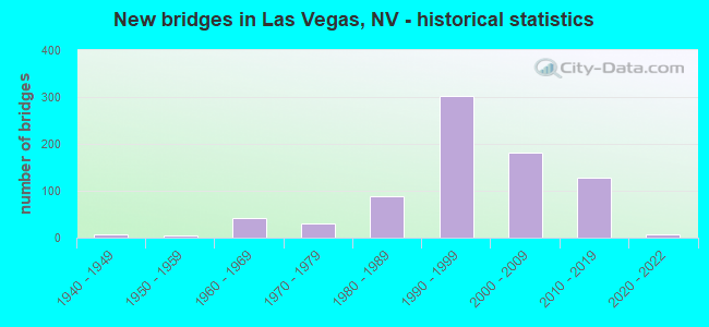
- New bridges - historical statistics
- 11930-1939
- 61940-1949
- 41950-1959
- 431960-1969
- 301970-1979
- 891980-1989
- 3021990-1999
- 1822000-2009
- 1292010-2019
- 72020-2022

- Reconstructed bridges - Historical Statistics
- 11940-1949
- 01950-1959
- 21960-1969
- 01970-1979
- 01980-1989
- 31990-1999
- 152000-2009
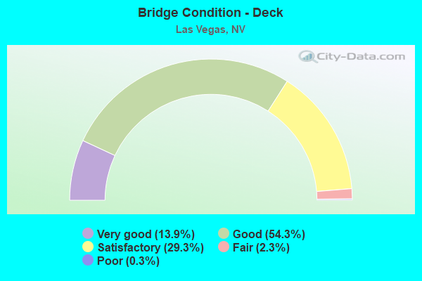
- Bridge Condition - Deck
- 13.9%Very good
- 54.3%Good
- 29.3%Satisfactory
- 2.3%Fair
- 0.3%Poor
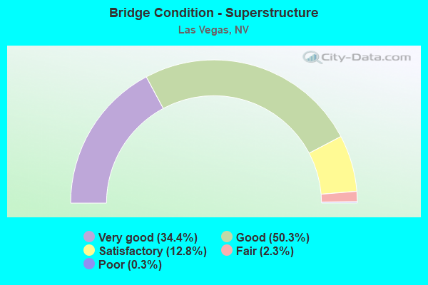
- Bridge Condition - Superstructure
- 34.4%Very good
- 50.3%Good
- 12.8%Satisfactory
- 2.3%Fair
- 0.3%Poor
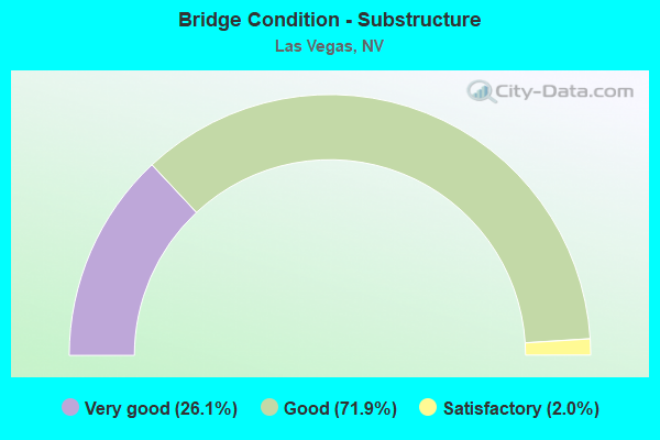
- Bridge Condition - Substructure
- 26.1%Very good
- 71.9%Good
- 2.0%Satisfactory
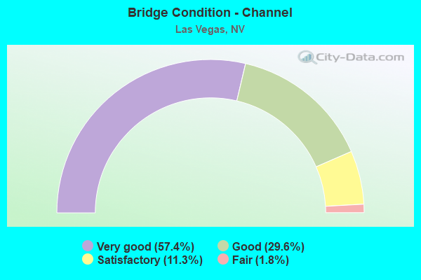
- Bridge Condition - Channel
- 57.4%Very good
- 29.6%Good
- 11.3%Satisfactory
- 1.8%Fair
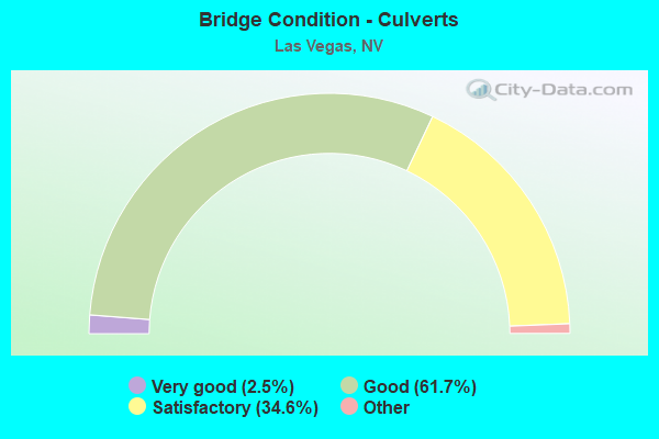
- Bridge Condition - Culverts
- 2.5%Very good
- 61.7%Good
- 34.6%Satisfactory
- 1.3%Fair
- 0.4%Poor
Find on map >> Show street view
Structure Number: B2438, Location: Las Vegas (Lat: 36.098611, Lng: -115.189444), Route carried "on" structure: County highway , Year Built: 1998, Status: Open, Structure Length: 0.61m (2.00ft), Average Daily Traffic: 1,500 (year 2017), Truck Traffic: 1%, Average Future Daily Traffic: 3,102 (year 2040), Design Load: HS 20+Mod, Features Intersected: Tropicana Wash, Facility Carried by Structure: Valley View
Minimum Vertical Clearance: 30+ m (98+ ft), Kilometerpoint: 0.000, Lanes on structure: 6, Owner: County Highway Agency, Approaching Roadway Width: 25.6m (84.0ft), Skew: 1 degrees, Material/Design: Concrete, Design/Construction: Culvert, Number Of Spans In Main Unit: 2, Length of Maximum Span: 2.9m (9.5ft)
Condition: Channel: Good, Culverts: Good, Inventory Rating: 75.7 metric tons, Method Used To Determine Inventory Rating: Load Factor (LF), Structural Evaluation: Better than present minimum criteria, Waterway Adequacy: Better than present minimum criteria, Approach Roadway Alignment: Equal to present desirable criteria, Designated Inspection Frequency: Every 48 months, Inspection Date: Febuary 2021, Deck Structure Type: Concrete Cast-file-Place, Wearing Surface/Protective System: Wearing Surface: Bituminous
Find on map >> Show street view
Structure Number: B244, Location: LAS VEGAS (Lat: 36.115444, Lng: -115.150417), Route carried "on" structure: County highway , Year Built: 1992, Status: Open, Structure Length: 1.95m (6.40ft), Average Daily Traffic: 660 (year 2017), Average Future Daily Traffic: 1,365 (year 2040), Design Load: HS 20+Mod, Features Intersected: FLAMINGO WASH, Facility Carried by Structure: PALO VERDE RD
Minimum Vertical Clearance: 30+ m (98+ ft), Kilometerpoint: 0.000, Lanes on structure: 2, Owner: County Highway Agency, Approaching Roadway Width: 15.0m (49.2ft), Material/Design: Concrete, Design/Construction: Culvert, Number Of Spans In Main Unit: 5, Length of Maximum Span: 3.6m (11.8ft), Curb or Sidewalk Widths: Left: 1.3m (4.3ft), Right: 1.3m (4.3ft), Curb-To-Curb Width: 15.0m (49.2ft), Out-to-Out Width: 19.0m (62.3ft)
Condition: Channel: Good, Culverts: Good, Operating Rating: 74.3 metric tons, Method Used To Determine Operating Rating: Load Factor (LF), Inventory Rating: 44.5 metric tons, Method Used To Determine Inventory Rating: Load Factor (LF), Structural Evaluation: Better than present minimum criteria, Deck Geometry: Superior to present desirable criteria, Waterway Adequacy: Equal to present desirable criteria, Approach Roadway Alignment: Equal to present desirable criteria, Designated Inspection Frequency: Every 48 months, Inspection Date: January 2021
Find on map >> Show street view
Structure Number: B2441, Location: Las Vegas (Lat: 36.116414, Lng: -115.154908), Route carried "on" structure: County highway , Year Built: 1992, Status: Open, Structure Length: 0.94m (3.08ft), Average Daily Traffic: 1,000 (year 2017), Truck Traffic: 1%, Average Future Daily Traffic: 2,068 (year 2040), Design Load: HS 20+Mod, Features Intersected: Flamingo Wash, Facility Carried by Structure: Paradise Rd
Minimum Vertical Clearance: 30+ m (98+ ft), Kilometerpoint: 0.000, Lanes on structure: 5, Owner: County Highway Agency, Approaching Roadway Width: 18.3m (60.0ft), Material/Design: Concrete, Design/Construction: Culvert, Number Of Spans In Main Unit: 2, Length of Maximum Span: 4.6m (15.1ft), Curb or Sidewalk Widths: Left: 1.5m (4.9ft), Right: 1.5m (4.9ft)
Condition: Channel: Good, Culverts: Good, Operating Rating: 81.9 metric tons, Method Used To Determine Operating Rating: Load Factor (LF), Inventory Rating: 49.3 metric tons, Method Used To Determine Inventory Rating: Load Factor (LF), Structural Evaluation: Better than present minimum criteria, Waterway Adequacy: Equal to present desirable criteria, Approach Roadway Alignment: Equal to present desirable criteria, Designated Inspection Frequency: Every 48 months, Inspection Date: Febuary 2021, Deck Structure Type: Concrete Cast-file-Place, Wearing Surface/Protective System: Wearing Surface: Bituminous
Find on map >> Show street view
Structure Number: B2491, Location: NW LAS VEGAS (Lat: 36.278636, Lng: -115.278847), Route carried "on" structure: County highway , Year Built: 2000, Status: Open, Structure Length: 0.61m (2.00ft), Average Daily Traffic: 633 (year 2017), Truck Traffic: 1%, Average Future Daily Traffic: 6,250 (year 2040), Design Load: HS 20, Features Intersected: CHANNEL, Facility Carried by Structure: GRAND MONTECITO
Minimum Vertical Clearance: 30+ m (98+ ft), Kilometerpoint: 0.000, Lanes on structure: 4, Owner: County Highway Agency, Approaching Roadway Width: 18.2m (59.7ft), Skew: 20 degrees, Material/Design: Concrete, Design/Construction: Culvert, Number Of Spans In Main Unit: 1, Length of Maximum Span: 6.1m (20.0ft), Curb or Sidewalk Widths: Left: 1.5m (4.9ft), Right: 1.7m (5.6ft)
Condition: Channel: Good, Culverts: Good, Inventory Rating: 82.5 metric tons, Method Used To Determine Inventory Rating: Load Factor (LF), Structural Evaluation: Better than present minimum criteria, Waterway Adequacy: Equal to present desirable criteria, Approach Roadway Alignment: Equal to present desirable criteria, Designated Inspection Frequency: Every 48 months, Inspection Date: December 2019
Find on map >> Show street view
Structure Number: B2494, Location: NW LAS VEGAS (Lat: 36.275694, Lng: -115.215417), Route carried "on" structure: County highway , Year Built: 2001, Status: Open, Structure Length: 1.70m (5.58ft), Average Daily Traffic: 4,500 (year 2017), Truck Traffic: 1%, Average Future Daily Traffic: 5,700 (year 2040), Design Load: HS 20+Mod, Features Intersected: CHANNEL, Facility Carried by Structure: BRADLEY RD
Minimum Vertical Clearance: 30+ m (98+ ft), Kilometerpoint: 0.000, Lanes on structure: 4, Owner: County Highway Agency, Approaching Roadway Width: 13.1m (43.0ft), Skew: 20 degrees, Material/Design: Concrete, Design/Construction: Culvert, Number Of Spans In Main Unit: 3, Length of Maximum Span: 5.8m (19.0ft), Curb or Sidewalk Widths: Left: 1.9m (6.2ft), Right: 2.1m (6.9ft)
Condition: Channel: Very good, Culverts: Good, Structural Evaluation: Better than present minimum criteria, Waterway Adequacy: Equal to present desirable criteria, Approach Roadway Alignment: Equal to present desirable criteria, Designated Inspection Frequency: Every 48 months, Inspection Date: November 2021
Find on map >> Show street view
Structure Number: B2496, Location: NW LAS VEGAS (Lat: 36.275867, Lng: -115.206658), Route carried "on" structure: County highway , Year Built: 2002, Status: Open, Structure Length: 1.70m (5.58ft), Average Daily Traffic: 20,000 (year 2017), Truck Traffic: 1%, Average Future Daily Traffic: 18,400 (year 2040), Features Intersected: CHANNEL, Facility Carried by Structure: DECATUR
Minimum Vertical Clearance: 30+ m (98+ ft), Kilometerpoint: 0.000, Lanes on structure: 8, Owner: County Highway Agency, Approaching Roadway Width: 20.8m (68.2ft), Skew: 20 degrees, Material/Design: Concrete, Design/Construction: Culvert, Number Of Spans In Main Unit: 4, Length of Maximum Span: 4.1m (13.5ft)
Condition: Channel: Very good, Culverts: Good, Operating Rating: 32.7 metric tons, Method Used To Determine Operating Rating: Field evaluation and documented engineering judgment, Inventory Rating: 19.6 metric tons, Method Used To Determine Inventory Rating: Field evaluation and documented engineering judgment, Structural Evaluation: Meets minimum limits, Waterway Adequacy: Equal to present desirable criteria, Approach Roadway Alignment: Equal to present desirable criteria, Designated Inspection Frequency: Every 24 months, Inspection Date: November 2021
Find on map >> Show street view
Structure Number: B2505, Location: SOUTH WEST LAS VEGAS (Lat: 36.095417, Lng: -115.199150), Route carried "on" structure: City street , Year Built: 1995, Status: Open, Structure Length: 1.09m (3.58ft), Average Daily Traffic: 380 (year 2017), Average Future Daily Traffic: 786 (year 2040), Design Load: HS 20+Mod, Features Intersected: TROPICANA BRANCH WASH, Facility Carried by Structure: ARVILLE ST
Minimum Vertical Clearance: 30+ m (98+ ft), Kilometerpoint: 0.000, Lanes on structure: 4, Owner: County Highway Agency, Approaching Roadway Width: 21.2m (69.6ft), Skew: 1 degrees, Material/Design: Concrete, Design/Construction: Culvert, Number Of Spans In Main Unit: 3, Length of Maximum Span: 3.2m (10.5ft), Curb or Sidewalk Widths: Left: 1.7m (5.6ft), Right: 1.7m (5.6ft)
Condition: Channel: Good, Culverts: Good, Operating Rating: 64.8 metric tons, Method Used To Determine Operating Rating: Load Factor (LF), Inventory Rating: 38.8 metric tons, Method Used To Determine Inventory Rating: Load Factor (LF), Structural Evaluation: Better than present minimum criteria, Waterway Adequacy: Equal to present desirable criteria, Approach Roadway Alignment: Equal to present desirable criteria, Designated Inspection Frequency: Every 48 months, Inspection Date: January 2021
Find on map >> Show street view
Structure Number: B2523, Location: LAS VEGAS (Lat: 36.093197, Lng: -115.214681), Route carried "on" structure: County highway , Year Built: 1998, Status: Open, Structure Length: 0.79m (2.59ft), Average Daily Traffic: 2,750 (year 2017), Average Future Daily Traffic: 5,687 (year 2040), Design Load: HS 20+Mod, Features Intersected: N.FORK TROPICANA WASH, Facility Carried by Structure: HACIENDA AV
Minimum Vertical Clearance: 30+ m (98+ ft), Kilometerpoint: 0.000, Lanes on structure: 4, Owner: County Highway Agency, Approaching Roadway Width: 20.8m (68.2ft), Skew: 3 degrees, Material/Design: Concrete, Design/Construction: Culvert, Number Of Spans In Main Unit: 1, Length of Maximum Span: 7.9m (25.9ft), Curb or Sidewalk Widths: Left: 2.0m (6.6ft), Right: 1.7m (5.6ft)
Condition: Channel: Satisfactory, Culverts: Good, Operating Rating: 89.1 metric tons, Method Used To Determine Operating Rating: Load Factor (LF), Inventory Rating: 49.3 metric tons, Method Used To Determine Inventory Rating: Load Factor (LF), Structural Evaluation: Better than present minimum criteria, Waterway Adequacy: Equal to present desirable criteria, Approach Roadway Alignment: Equal to present desirable criteria, Designated Inspection Frequency: Every 48 months, Inspection Date: December 2020
Find on map >> Show street view
Structure Number: B2524, Location: EAST LAS VEGAS (Lat: 36.091172, Lng: -115.046136), Route carried "on" structure: County highway , Year Built: 2001, Status: Open, Structure Length: 2.65m (8.69ft), Average Daily Traffic: 12,000 (year 2017), Truck Traffic: 1%, Average Future Daily Traffic: 10,000 (year 2040), Design Load: HS 20, Features Intersected: DUCK CRK, Facility Carried by Structure: STEPHANIE ST
Minimum Vertical Clearance: 30+ m (98+ ft), Kilometerpoint: 0.000, Lanes on structure: 2, Owner: County Highway Agency, Approaching Roadway Width: 10.1m (33.1ft), Skew: 1 degrees, Material/Design: Steel, Design/Construction: Stringer/Multi-beam, Number Of Spans In Main Unit: 1, Length of Maximum Span: 25.2m (82.7ft), Curb or Sidewalk Widths: Left: 1.3m (4.3ft), Right: 1.4m (4.6ft), Curb-To-Curb Width: 21.0m (68.9ft), Out-to-Out Width: 24.4m (80.1ft)
Condition: Deck: Good, Superstructure: Very good, Substructure: Very good, Channel: Very good, Operating Rating: 72.5 metric tons, Method Used To Determine Operating Rating: Load Factor (LF), Inventory Rating: 35.9 metric tons, Method Used To Determine Inventory Rating: Load Factor (LF), Structural Evaluation: Equal to present desirable criteria, Deck Geometry: Superior to present desirable criteria, Waterway Adequacy: Equal to present desirable criteria, Approach Roadway Alignment: Equal to present desirable criteria, Designated Inspection Frequency: Every 24 months, Inspection Date: November 2021, Deck Structure Type: Concrete Cast-file-Place, Wearing Surface/Protective System: Wearing Surface: Monolithic Concrete
Find on map >> Show street view
Structure Number: B2542, Location: SUMMERLIN (Lat: 36.191608, Lng: -115.316231), Route carried "on" structure: City street , Year Built: 1999, Status: Open, Structure Length: 0.84m (2.76ft), Average Daily Traffic: 2,300 (year 2017), Average Future Daily Traffic: 4,757 (year 2040), Features Intersected: CHANNEL, Facility Carried by Structure: CRESTDALE LN
Minimum Vertical Clearance: 30+ m (98+ ft), Kilometerpoint: 0.000, Lanes on structure: 4, Owner: City or Municipal Highway Agency, Approaching Roadway Width: 18.4m (60.4ft), Material/Design: Concrete, Design/Construction: Culvert, Number Of Spans In Main Unit: 3, Length of Maximum Span: 2.7m (8.9ft), Curb or Sidewalk Widths: Left: 2.0m (6.6ft), Right: 0.0m
Condition: Channel: Very good, Culverts: Satisfactory, Operating Rating: 32.7 metric tons, Method Used To Determine Operating Rating: Field evaluation and documented engineering judgment, Inventory Rating: 19.6 metric tons, Method Used To Determine Inventory Rating: Field evaluation and documented engineering judgment, Structural Evaluation: Somewhat better than minimum adequacy, Waterway Adequacy: Equal to present desirable criteria, Approach Roadway Alignment: Equal to present desirable criteria, Designated Inspection Frequency: Every 24 months, Inspection Date: January 2020
Find on map >> Show street view
Structure Number: B2543, Location: LAS VEGAS (Lat: 36.158994, Lng: -115.301153), Route carried "on" structure: County highway , Year Built: 1992, Status: Open, Structure Length: 0.84m (2.76ft), Average Daily Traffic: 5,500 (year 2017), Average Future Daily Traffic: 11,375 (year 2040), Design Load: HS 20+Mod, Features Intersected: CHANNEL, Facility Carried by Structure: W. CHARLESTON BLVD
Minimum Vertical Clearance: 30+ m (98+ ft), Kilometerpoint: 0.000, Lanes on structure: 6, Owner: City or Municipal Highway Agency, Approaching Roadway Width: 25.0m (82.0ft), Skew: 24 degrees, Material/Design: Concrete, Design/Construction: Culvert, Number Of Spans In Main Unit: 3, Length of Maximum Span: 2.5m (8.2ft), Curb or Sidewalk Widths: Left: 1.6m (5.2ft), Right: 0.0m
Condition: Channel: Good, Culverts: Good, Operating Rating: 57.4 metric tons, Method Used To Determine Operating Rating: Load Factor (LF), Inventory Rating: 34.5 metric tons, Method Used To Determine Inventory Rating: Load Factor (LF), Structural Evaluation: Better than present minimum criteria, Waterway Adequacy: Equal to present desirable criteria, Approach Roadway Alignment: Equal to present desirable criteria, Designated Inspection Frequency: Every 48 months, Inspection Date: November 2021
Find on map >> Show street view
Structure Number: B2544, Location: LAS VEGAS (Lat: 36.232164, Lng: -115.260847), Route carried "on" structure: City street , Year Built: 1999, Status: Open, Structure Length: 1.23m (4.04ft), Average Daily Traffic: 9,500 (year 2017), Average Future Daily Traffic: 19,647 (year 2040), Features Intersected: GOWAN CHANNEL, Facility Carried by Structure: BUFFALO DRIVE
Minimum Vertical Clearance: 30+ m (98+ ft), Kilometerpoint: 0.000, Lanes on structure: 7, Owner: City or Municipal Highway Agency, Approaching Roadway Width: 26.8m (87.9ft), Material/Design: Concrete, Design/Construction: Culvert, Number Of Spans In Main Unit: 2, Length of Maximum Span: 6.0m (19.7ft)
Condition: Channel: Very good, Culverts: Good, Operating Rating: 32.7 metric tons, Method Used To Determine Operating Rating: Field evaluation and documented engineering judgment, Inventory Rating: 19.6 metric tons, Method Used To Determine Inventory Rating: Field evaluation and documented engineering judgment, Structural Evaluation: Meets minimum limits, Waterway Adequacy: Equal to present desirable criteria, Approach Roadway Alignment: Equal to present desirable criteria, Designated Inspection Frequency: Every 24 months, Inspection Date: November 2021
Find on map >> Show street view
Structure Number: B2545, Location: LAS VEGAS (Lat: 36.095378, Lng: -115.208000), Route carried "on" structure: County highway , Year Built: 1996, Status: Open, Structure Length: 0.83m (2.72ft), Average Daily Traffic: 38,000 (year 2017), Average Future Daily Traffic: 78,588 (year 2040), Design Load: HS 20+Mod, Features Intersected: N. FORK TROPICANA WASH, Facility Carried by Structure: DECATUR BLVD
Minimum Vertical Clearance: 30+ m (98+ ft), Kilometerpoint: 0.000, Lanes on structure: 7, Owner: County Highway Agency, Approaching Roadway Width: 32.2m (105.6ft), Material/Design: Concrete, Design/Construction: Culvert, Number Of Spans In Main Unit: 3, Length of Maximum Span: 2.5m (8.2ft), Curb or Sidewalk Widths: Left: 1.4m (4.6ft), Right: 1.4m (4.6ft)
Condition: Channel: Satisfactory, Culverts: Satisfactory, Operating Rating: 64.3 metric tons, Method Used To Determine Operating Rating: Load Factor (LF), Inventory Rating: 38.5 metric tons, Method Used To Determine Inventory Rating: Load Factor (LF), Structural Evaluation: Equal to present minimum criteria, Waterway Adequacy: Equal to present desirable criteria, Approach Roadway Alignment: Equal to present desirable criteria, Designated Inspection Frequency: Every 48 months, Inspection Date: December 2020
Find on map >> Show street view
Structure Number: B2547, Location: LAS VEGAS (Lat: 36.094264, Lng: -115.212311), Route carried "on" structure: County highway , Year Built: 1998, Status: Open, Structure Length: 0.82m (2.69ft), Average Daily Traffic: 380 (year 2017), Average Future Daily Traffic: 786 (year 2040), Design Load: HS 20+Mod, Features Intersected: N.FORK TR0PICANA WASH, Facility Carried by Structure: EDMOND ST.
Minimum Vertical Clearance: 30+ m (98+ ft), Kilometerpoint: 0.000, Lanes on structure: 2, Owner: County Highway Agency, Approaching Roadway Width: 15.0m (49.2ft), Skew: 2 degrees, Material/Design: Concrete, Design/Construction: Culvert, Number Of Spans In Main Unit: 2, Length of Maximum Span: 3.9m (12.8ft), Curb or Sidewalk Widths: Left: 1.7m (5.6ft), Right: 1.7m (5.6ft)
Condition: Channel: Very good, Culverts: Good, Structural Evaluation: Better than present minimum criteria, Waterway Adequacy: Equal to present desirable criteria, Approach Roadway Alignment: Equal to present desirable criteria, Designated Inspection Frequency: Every 48 months, Inspection Date: December 2020
Find on map >> Show street view
Structure Number: B2548, Location: LAS VEGAS (Lat: 36.095300, Lng: -115.203903), Route carried "on" structure: County highway , Year Built: 1999, Status: Open, Structure Length: 0.92m (3.02ft), Average Daily Traffic: 1,100 (year 2017), Average Future Daily Traffic: 2,275 (year 2040), Design Load: HS 20+Mod, Features Intersected: N.FORK TROPICANA WASH, Facility Carried by Structure: CAMERON ST.
Minimum Vertical Clearance: 30+ m (98+ ft), Kilometerpoint: 0.000, Lanes on structure: 2, Owner: County Highway Agency, Approaching Roadway Width: 15.0m (49.2ft), Material/Design: Concrete, Design/Construction: Culvert, Number Of Spans In Main Unit: 3, Length of Maximum Span: 2.4m (7.9ft), Curb or Sidewalk Widths: Left: 1.4m (4.6ft), Right: 1.4m (4.6ft)
Condition: Channel: Good, Culverts: Satisfactory, Operating Rating: 49.6 metric tons, Method Used To Determine Operating Rating: Load Factor (LF), Inventory Rating: 29.7 metric tons, Method Used To Determine Inventory Rating: Load Factor (LF), Structural Evaluation: Equal to present minimum criteria, Waterway Adequacy: Equal to present desirable criteria, Approach Roadway Alignment: Equal to present desirable criteria, Designated Inspection Frequency: Every 24 months, Inspection Date: December 2020
Find on map >> Show street view
Structure Number: B2559, Location: LAS VEGAS (Lat: 36.091342, Lng: -115.216622), Route carried "on" structure: County highway , Year Built: 1999, Status: Open, Structure Length: 0.70m (2.30ft), Average Daily Traffic: 5,000 (year 2017), Average Future Daily Traffic: 7,900 (year 2040), Design Load: HS 20+Mod, Features Intersected: N.FORK TROPICANA WASH, Facility Carried by Structure: LINDELL ROAD
Minimum Vertical Clearance: 30+ m (98+ ft), Kilometerpoint: 0.000, Lanes on structure: 4, Owner: County Highway Agency, Approaching Roadway Width: 21.2m (69.6ft), Material/Design: Concrete, Design/Construction: Culvert, Number Of Spans In Main Unit: 2, Length of Maximum Span: 3.4m (11.2ft), Curb or Sidewalk Widths: Left: 1.7m (5.6ft), Right: 1.7m (5.6ft)
Condition: Channel: Very good, Culverts: Good, Operating Rating: 79.3 metric tons, Method Used To Determine Operating Rating: Load Factor (LF), Inventory Rating: 47.6 metric tons, Method Used To Determine Inventory Rating: Load Factor (LF), Structural Evaluation: Better than present minimum criteria, Waterway Adequacy: Equal to present desirable criteria, Approach Roadway Alignment: Equal to present desirable criteria, Designated Inspection Frequency: Every 48 months, Inspection Date: December 2020
Find on map >> Show street view
Structure Number: B2566, Location: LAS VEGAS (Lat: 36.232583, Lng: -115.269772), Route carried "on" structure: City street , Year Built: 1999, Status: Open, Structure Length: 0.91m (2.99ft), Average Daily Traffic: 5,000 (year 2017), Average Future Daily Traffic: 7,900 (year 2040), Features Intersected: GOWAN CHANNEL, Facility Carried by Structure: CIMARRON ST.
Minimum Vertical Clearance: 30+ m (98+ ft), Kilometerpoint: 0.000, Lanes on structure: 3, Owner: City or Municipal Highway Agency, Approaching Roadway Width: 21.0m (68.9ft), Material/Design: Concrete, Design/Construction: Slab, Number Of Spans In Main Unit: 1, Length of Maximum Span: 9.1m (29.9ft), Curb or Sidewalk Widths: Left: 1.4m (4.6ft), Right: 1.4m (4.6ft), Curb-To-Curb Width: 21.0m (68.9ft), Out-to-Out Width: 24.4m (80.1ft)
Condition: Deck: Good, Superstructure: Good, Substructure: Good, Channel: Very good, Operating Rating: 32.7 metric tons, Method Used To Determine Operating Rating: Field evaluation and documented engineering judgment, Inventory Rating: 19.6 metric tons, Method Used To Determine Inventory Rating: Field evaluation and documented engineering judgment, Structural Evaluation: Somewhat better than minimum adequacy, Deck Geometry: Superior to present desirable criteria, Waterway Adequacy: Equal to present desirable criteria, Approach Roadway Alignment: Equal to present desirable criteria, Designated Inspection Frequency: Every 24 months, Inspection Date: November 2021, Deck Structure Type: Concrete Cast-file-Place, Wearing Surface/Protective System: Wearing Surface: Monolithic Concrete
Find on map >> Show street view
Structure Number: B2567, Location: LAS VEGAS (Lat: 36.233483, Lng: -115.278678), Route carried "on" structure: City street , Year Built: 1999, Status: Open, Structure Length: 1.25m (4.10ft), Average Daily Traffic: 6,600 (year 2017), Average Future Daily Traffic: 13,650 (year 2040), Design Load: HS 20+Mod, Features Intersected: GOWAN CHANNEL, Facility Carried by Structure: DURANGO/ALEXANDER
Minimum Vertical Clearance: 30+ m (98+ ft), Kilometerpoint: 0.000, Lanes on structure: 7, Owner: City or Municipal Highway Agency, Approaching Roadway Width: 32.6m (107.0ft), Skew: 24 degrees, Material/Design: Concrete, Design/Construction: Culvert, Number Of Spans In Main Unit: 2, Length of Maximum Span: 6.2m (20.3ft), Curb or Sidewalk Widths: Left: 1.7m (5.6ft), Right: 0.0m
Condition: Channel: Very good, Culverts: Good, Operating Rating: 67.6 metric tons, Method Used To Determine Operating Rating: Load Factor (LF), Inventory Rating: 40.5 metric tons, Method Used To Determine Inventory Rating: Load Factor (LF), Structural Evaluation: Better than present minimum criteria, Waterway Adequacy: Equal to present desirable criteria, Approach Roadway Alignment: Equal to present desirable criteria, Designated Inspection Frequency: Every 48 months, Inspection Date: November 2021
Find on map >> Show street view
Structure Number: B2611, Location: EAST LAS VEGAS (Lat: 36.151086, Lng: -115.034250), Route carried "on" structure: County highway , Year Built: 1995, Status: Open, Structure Length: 0.63m (2.07ft), Average Daily Traffic: 2,200 (year 2017), Truck Traffic: 2%, Average Future Daily Traffic: 4,550 (year 2040), Design Load: HS 20, Features Intersected: ORCHARDS CHANNEL, Facility Carried by Structure: TREE LINE DR
Minimum Vertical Clearance: 30+ m (98+ ft), Kilometerpoint: 0.000, Lanes on structure: 5, Owner: County Highway Agency, Approaching Roadway Width: 21.2m (69.6ft), Material/Design: Concrete, Design/Construction: Culvert, Number Of Spans In Main Unit: 2, Length of Maximum Span: 3.1m (10.2ft), Curb or Sidewalk Widths: Left: 2.9m (9.5ft), Right: 0.2m (0.7ft)
Condition: Channel: Good, Culverts: Satisfactory, Operating Rating: 46.3 metric tons, Method Used To Determine Operating Rating: Load Factor (LF), Inventory Rating: 27.8 metric tons, Method Used To Determine Inventory Rating: Load Factor (LF), Structural Evaluation: Equal to present minimum criteria, Waterway Adequacy: Equal to present desirable criteria, Approach Roadway Alignment: Superior to present desirable criteria, Designated Inspection Frequency: Every 24 months, Inspection Date: December 2020
Find on map >> Show street view
Structure Number: B2624, Location: EAST LAS VEGAS (Lat: 36.149064, Lng: -115.039844), Route carried "on" structure: County highway , Year Built: 1993, Status: Open, Structure Length: 1.30m (4.27ft), Average Daily Traffic: 1,650 (year 2017), Truck Traffic: 1%, Average Future Daily Traffic: 3,412 (year 2040), Design Load: HS 20, Features Intersected: ORCHARDS CHANNEL, Facility Carried by Structure: ORCHARD VALLEY DR
Minimum Vertical Clearance: 30+ m (98+ ft), Kilometerpoint: 0.000, Lanes on structure: 2, Owner: County Highway Agency, Approaching Roadway Width: 14.0m (45.9ft), Material/Design: Concrete, Design/Construction: Culvert, Number Of Spans In Main Unit: 4, Length of Maximum Span: 3.0m (9.8ft), Curb or Sidewalk Widths: Left: 2.1m (6.9ft), Right: 2.0m (6.6ft)
Condition: Channel: Good, Culverts: Good, Operating Rating: 48.6 metric tons, Method Used To Determine Operating Rating: Load Factor (LF), Inventory Rating: 32.3 metric tons, Method Used To Determine Inventory Rating: Load Factor (LF), Structural Evaluation: Better than present minimum criteria, Waterway Adequacy: Equal to present desirable criteria, Approach Roadway Alignment: Superior to present desirable criteria, Designated Inspection Frequency: Every 24 months, Inspection Date: December 2020
Find on map >> Show street view
Structure Number: B2643, Location: WEST LAS VEGAS (Lat: 36.087208, Lng: -115.279219), Route carried "on" structure: County highway , Year Built: 2000, Status: Open, Structure Length: 0.91m (2.99ft), Average Daily Traffic: 4,400 (year 2017), Truck Traffic: 2%, Average Future Daily Traffic: 9,100 (year 2040), Design Load: HS 20+Mod, Features Intersected: DRAINAGE, Facility Carried by Structure: DURANGO RD
Minimum Vertical Clearance: 30+ m (98+ ft), Kilometerpoint: 0.000, Lanes on structure: 7, Owner: County Highway Agency, Approaching Roadway Width: 25.9m (85.0ft), Material/Design: Concrete, Design/Construction: Culvert, Number Of Spans In Main Unit: 1, Length of Maximum Span: 8.5m (27.9ft)
Condition: Channel: Good, Culverts: Satisfactory, Structural Evaluation: Equal to present minimum criteria, Waterway Adequacy: Superior to present desirable criteria, Approach Roadway Alignment: Superior to present desirable criteria, Designated Inspection Frequency: Every 48 months, Inspection Date: December 2020
Find on map >> Show street view
Structure Number: B2649, Location: EAST LAS VEGAS (Lat: 36.109214, Lng: -115.110081), Route carried "on" structure: County highway , Year Built: 1992, Status: Open, Structure Length: 0.70m (2.30ft), Average Daily Traffic: 5,600 (year 2017), Truck Traffic: 1%, Average Future Daily Traffic: 11,581 (year 2040), Design Load: HS 20, Features Intersected: VAN BUSKIRK CHANNEL, Facility Carried by Structure: MCCLEOD DR
Minimum Vertical Clearance: 30+ m (98+ ft), Kilometerpoint: 0.000, Lanes on structure: 3, Owner: County Highway Agency, Approaching Roadway Width: 20.4m (66.9ft), Skew: 3 degrees, Material/Design: Concrete, Design/Construction: Culvert, Number Of Spans In Main Unit: 2, Length of Maximum Span: 3.5m (11.5ft), Curb or Sidewalk Widths: Left: 2.0m (6.6ft), Right: 2.0m (6.6ft)
Condition: Channel: Very good, Culverts: Satisfactory, Operating Rating: 64.6 metric tons, Method Used To Determine Operating Rating: Load Factor (LF), Inventory Rating: 38.5 metric tons, Method Used To Determine Inventory Rating: Load Factor (LF), Structural Evaluation: Equal to present minimum criteria, Waterway Adequacy: Equal to present desirable criteria, Approach Roadway Alignment: Equal to present desirable criteria, Designated Inspection Frequency: Every 48 months, Inspection Date: November 2021
Find on map >> Show street view
Structure Number: B2656, Location: LAS VEGAS (Lat: 36.087689, Lng: -115.171128), Route carried "on" structure: County highway , Year Built: 1996, Status: Open, Structure Length: 0.65m (2.13ft), Average Daily Traffic: 1,100 (year 2017), Average Future Daily Traffic: 2,275 (year 2040), Design Load: HS 20, Features Intersected: WEST SIDE CHANNEL, Facility Carried by Structure: AIRPORT ACCESS RD
Minimum Vertical Clearance: 30+ m (98+ ft), Kilometerpoint: 0.000, Lanes on structure: 2, Owner: County Highway Agency, Approaching Roadway Width: 9.6m (31.5ft), Material/Design: Concrete, Design/Construction: Culvert, Number Of Spans In Main Unit: 2, Length of Maximum Span: 3.1m (10.2ft)
Condition: Channel: Very good, Culverts: Good, Inventory Rating: 56.1 metric tons, Method Used To Determine Inventory Rating: Load Factor (LF), Structural Evaluation: Better than present minimum criteria, Waterway Adequacy: Equal to present desirable criteria, Approach Roadway Alignment: Equal to present desirable criteria, Designated Inspection Frequency: Every 48 months, Inspection Date: January 2021, Deck Structure Type: Concrete Cast-file-Place, Wearing Surface/Protective System: Wearing Surface: Bituminous
Find on map >> Show street view
Structure Number: B2657, Location: LAS VEGAS (Lat: 36.089767, Lng: -115.170275), Route carried "on" structure: County highway , Year Built: 1994, Status: Open, Structure Length: 1.19m (3.90ft), Average Daily Traffic: 1,000 (year 2017), Average Future Daily Traffic: 2,068 (year 2040), Design Load: HS 20, Features Intersected: WESTSIDE CHNL, Facility Carried by Structure: DIABLO DR
Minimum Vertical Clearance: 30+ m (98+ ft), Kilometerpoint: 0.000, Lanes on structure: 2, Owner: County Highway Agency, Approaching Roadway Width: 9.8m (32.2ft), Material/Design: Concrete, Design/Construction: Slab, Number Of Spans In Main Unit: 1, Length of Maximum Span: 11.6m (38.1ft), Curb-To-Curb Width: 9.8m (32.2ft), Out-to-Out Width: 10.7m (35.1ft)
Condition: Deck: Good, Superstructure: Good, Substructure: Good, Channel: Good, Operating Rating: 61.0 metric tons, Method Used To Determine Operating Rating: Load Factor (LF), Inventory Rating: 36.6 metric tons, Method Used To Determine Inventory Rating: Load Factor (LF), Structural Evaluation: Better than present minimum criteria, Deck Geometry: Equal to present minimum criteria, Waterway Adequacy: Equal to present desirable criteria, Approach Roadway Alignment: Equal to present desirable criteria, Designated Inspection Frequency: Every 48 months, Inspection Date: January 2021, Deck Structure Type: Concrete Cast-file-Place, Wearing Surface/Protective System: Wearing Surface: Bituminous
Find on map >> Show street view
Structure Number: B2662, Location: NW LAS VEGAS (Lat: 36.305244, Lng: -115.246100), Route carried "on" structure: City street , Year Built: 2001, Status: Open, Structure Length: 2.08m (6.82ft), Average Daily Traffic: 12 (year 2017), Average Future Daily Traffic: 25 (year 2040), Design Load: HS 20, Features Intersected: NEW VISTA CHANNEL, Facility Carried by Structure: GRAND TETON DR
Minimum Vertical Clearance: 30+ m (98+ ft), Kilometerpoint: 0.000, Lanes on structure: 4, Owner: City or Municipal Highway Agency, Approaching Roadway Width: 11.2m (36.7ft), Skew: 34 degrees, Material/Design: Concrete, Design/Construction: Culvert, Number Of Spans In Main Unit: 4, Length of Maximum Span: 5.2m (17.1ft), Curb or Sidewalk Widths: Left: 1.7m (5.6ft), Right: 0.0m
Condition: Channel: Good, Culverts: Satisfactory, Operating Rating: 56.7 metric tons, Method Used To Determine Operating Rating: Load Factor (LF), Inventory Rating: 33.9 metric tons, Method Used To Determine Inventory Rating: Load Factor (LF), Structural Evaluation: Equal to present minimum criteria, Waterway Adequacy: Equal to present desirable criteria, Approach Roadway Alignment: Equal to present desirable criteria, Designated Inspection Frequency: Every 48 months, Inspection Date: December 2017
Find on map >> Show street view
Structure Number: B268, Location: LAS VEGAS (Lat: 36.099025, Lng: -115.181733), Route carried "on" structure: County highway , Year Built: 2001, Status: Open, Structure Length: 0.81m (2.66ft), Average Daily Traffic: 12,000 (year 2017), Truck Traffic: 1%, Average Future Daily Traffic: 12,500 (year 2040), Design Load: HS 20, Features Intersected: CHANNEL, Facility Carried by Structure: INDUSTRIAL RD
Minimum Vertical Clearance: 30+ m (98+ ft), Kilometerpoint: 0.000, Lanes on structure: 4, Owner: County Highway Agency, Approaching Roadway Width: 20.9m (68.6ft), Skew: 3 degrees, Material/Design: Concrete, Design/Construction: Culvert, Number Of Spans In Main Unit: 2, Length of Maximum Span: 3.3m (10.8ft), Curb or Sidewalk Widths: Left: 2.0m (6.6ft), Right: 1.4m (4.6ft)
Condition: Channel: Good, Culverts: Good, Operating Rating: 32.7 metric tons, Method Used To Determine Operating Rating: Load Factor (LF), Inventory Rating: 13.3 metric tons, Method Used To Determine Inventory Rating: Load Factor (LF), Structural Evaluation: High priority of corrective action, Waterway Adequacy: Equal to present desirable criteria, Approach Roadway Alignment: Equal to present desirable criteria, Designated Inspection Frequency: Every 24 months, Inspection Date: January 2021
Find on map >> Show street view
Structure Number: B2687, Location: SW LAS VEGAS (Lat: 36.088908, Lng: -115.225197), Route carried "on" structure: County highway , Year Built: 2000, Status: Open, Structure Length: 0.61m (2.00ft), Average Daily Traffic: 3,300 (year 2017), Truck Traffic: 1%, Average Future Daily Traffic: 6,825 (year 2040), Design Load: HS 20, Features Intersected: CHANNEL, Facility Carried by Structure: JONES BLVD
Minimum Vertical Clearance: 30+ m (98+ ft), Kilometerpoint: 0.000, Lanes on structure: 6, Owner: County Highway Agency, Approaching Roadway Width: 27.3m (89.6ft), Material/Design: Concrete, Design/Construction: Culvert, Number Of Spans In Main Unit: 1, Length of Maximum Span: 6.1m (20.0ft), Curb or Sidewalk Widths: Left: 1.7m (5.6ft), Right: 1.7m (5.6ft)
Condition: Channel: Very good, Culverts: Good, Structural Evaluation: Better than present minimum criteria, Waterway Adequacy: Equal to present desirable criteria, Approach Roadway Alignment: Equal to present desirable criteria, Designated Inspection Frequency: Every 48 months, Inspection Date: December 2020
Find on map >> Show street view
Structure Number: B2688, Location: SW LAS VEGAS (Lat: 36.089417, Lng: -115.216644), Route carried "on" structure: County highway , Year Built: 2000, Status: Open, Structure Length: 0.76m (2.49ft), Average Daily Traffic: 1,100 (year 2017), Truck Traffic: 1%, Average Future Daily Traffic: 7,900 (year 2040), Design Load: HS 20, Features Intersected: CHANNEL, Facility Carried by Structure: LINDELL RD
Minimum Vertical Clearance: 30+ m (98+ ft), Kilometerpoint: 0.000, Lanes on structure: 4, Owner: County Highway Agency, Approaching Roadway Width: 21.2m (69.6ft), Material/Design: Concrete, Design/Construction: Culvert, Number Of Spans In Main Unit: 1, Length of Maximum Span: 7.6m (24.9ft)
Condition: Channel: Very good, Culverts: Good, Structural Evaluation: Better than present minimum criteria, Waterway Adequacy: Equal to present desirable criteria, Approach Roadway Alignment: Equal to present desirable criteria, Designated Inspection Frequency: Every 48 months, Inspection Date: December 2020
Find on map >> Show street view
Structure Number: B2689, Location: SW LAS VEGAS (Lat: 36.086097, Lng: -115.212264), Route carried "on" structure: County highway , Year Built: 2000, Status: Open, Structure Length: 1.12m (3.67ft), Average Daily Traffic: 1,000 (year 2017), Average Future Daily Traffic: 54,000 (year 2040), Design Load: HS 20, Features Intersected: CHANNEL, Facility Carried by Structure: RUSSELL RD
Minimum Vertical Clearance: 30+ m (98+ ft), Kilometerpoint: 0.000, Lanes on structure: 5, Owner: County Highway Agency, Approaching Roadway Width: 27.3m (89.6ft), Skew: 4 degrees, Material/Design: Concrete, Design/Construction: Culvert, Number Of Spans In Main Unit: 1, Length of Maximum Span: 11.2m (36.7ft), Curb or Sidewalk Widths: Left: 1.7m (5.6ft), Right: 1.7m (5.6ft)
Condition: Channel: Very good, Culverts: Good, Structural Evaluation: Better than present minimum criteria, Waterway Adequacy: Equal to present desirable criteria, Approach Roadway Alignment: Equal to present desirable criteria, Designated Inspection Frequency: Every 48 months, Inspection Date: December 2020
Find on map >> Show street view
Structure Number: B269, Location: SW LAS VEGAS (Lat: 36.082664, Lng: -115.207594), Route carried "on" structure: County highway , Year Built: 2000, Status: Open, Structure Length: 1.10m (3.61ft), Average Daily Traffic: 32,000 (year 2017), Truck Traffic: 2%, Average Future Daily Traffic: 66,180 (year 2040), Design Load: HS 20, Features Intersected: CHANNEL, Facility Carried by Structure: DECATUR BLVD
Minimum Vertical Clearance: 30+ m (98+ ft), Kilometerpoint: 0.000, Lanes on structure: 7, Owner: County Highway Agency, Approaching Roadway Width: 32.9m (107.9ft), Skew: 4 degrees, Material/Design: Concrete, Design/Construction: Culvert, Number Of Spans In Main Unit: 1, Length of Maximum Span: 11.0m (36.1ft)
Condition: Channel: Very good, Culverts: Good, Structural Evaluation: Better than present minimum criteria, Waterway Adequacy: Equal to present desirable criteria, Approach Roadway Alignment: Equal to present desirable criteria, Designated Inspection Frequency: Every 48 months, Inspection Date: December 2020
Find on map >> Show street view
Structure Number: B2705, Location: SOUTH LAS VEGAS (Lat: 35.994775, Lng: -115.189728), Route carried "on" structure: County highway , Year Built: 2000, Status: Open, Structure Length: 1.26m (4.13ft), Average Daily Traffic: 12,000 (year 2017), Truck Traffic: 1%, Average Future Daily Traffic: 20,500 (year 2040), Design Load: HS 20+Mod, Features Intersected: PASEO DRAINAGE, Facility Carried by Structure: VALLEY VIEW BL
Minimum Vertical Clearance: 30+ m (98+ ft), Kilometerpoint: 0.000, Lanes on structure: 5, Owner: County Highway Agency, Approaching Roadway Width: 27.3m (89.6ft), Material/Design: Concrete, Design/Construction: Culvert, Number Of Spans In Main Unit: 2, Length of Maximum Span: 6.1m (20.0ft), Curb or Sidewalk Widths: Left: 1.5m (4.9ft), Right: 1.5m (4.9ft)
Condition: Channel: Good, Culverts: Satisfactory, Operating Rating: 32.7 metric tons, Method Used To Determine Operating Rating: Load Factor (LF), Inventory Rating: 19.6 metric tons, Method Used To Determine Inventory Rating: Load Factor (LF), Structural Evaluation: Meets minimum limits, Waterway Adequacy: Equal to present desirable criteria, Approach Roadway Alignment: Equal to present desirable criteria, Designated Inspection Frequency: Every 24 months, Inspection Date: December 2020
Find on map >> Show street view
Structure Number: B2706, Location: NW LAS VEGAS (Lat: 36.229275, Lng: -115.315531), Route carried "on" structure: City street , Year Built: 2001, Status: Open, Structure Length: 0.85m (2.79ft), Average Daily Traffic: 1,450 (year 2017), Average Future Daily Traffic: 2,999 (year 2040), Design Load: HS 20, Features Intersected: GILMORE CHANNEL, Facility Carried by Structure: HUALAPAI WAY
Minimum Vertical Clearance: 30+ m (98+ ft), Kilometerpoint: 0.000, Lanes on structure: 5, Owner: City or Municipal Highway Agency, Approaching Roadway Width: 22.5m (73.8ft), Material/Design: Concrete, Design/Construction: Culvert, Number Of Spans In Main Unit: 1, Length of Maximum Span: 8.5m (27.9ft), Curb or Sidewalk Widths: Left: 1.7m (5.6ft), Right: 1.7m (5.6ft)
Condition: Channel: Very good, Culverts: Good, Operating Rating: 52.3 metric tons, Method Used To Determine Operating Rating: Load Factor (LF), Inventory Rating: 31.3 metric tons, Method Used To Determine Inventory Rating: Load Factor (LF), Structural Evaluation: Better than present minimum criteria, Waterway Adequacy: Equal to present desirable criteria, Approach Roadway Alignment: Equal to present desirable criteria, Designated Inspection Frequency: Every 24 months, Inspection Date: January 2020
Find on map >> Show street view
Structure Number: B2708, Location: NW LAS VEGAS (Lat: 36.275681, Lng: -115.267989), Route carried "on" structure: Ramp US 95, Year Built: 1999, Status: Open, Structure Length: 0.75m (2.46ft), Average Daily Traffic: 2,300 (year 2017), Truck Traffic: 2%, Average Future Daily Traffic: 4,757 (year 2040), Design Load: HS 20+Mod, Features Intersected: CHANNEL
Minimum Vertical Clearance: 30+ m (98+ ft), Kilometerpoint: 0.000, Lanes on structure: 3, Owner: County Highway Agency, Approaching Roadway Width: 16.0m (52.5ft), Skew: 20 degrees, Material/Design: Concrete, Design/Construction: Culvert, Number Of Spans In Main Unit: 2, Length of Maximum Span: 3.7m (12.1ft)
Condition: Channel: Very good, Culverts: Good, Operating Rating: 86.7 metric tons, Method Used To Determine Operating Rating: Load Factor (LF), Inventory Rating: 52.1 metric tons, Method Used To Determine Inventory Rating: Load Factor (LF), Structural Evaluation: Better than present minimum criteria, Waterway Adequacy: Equal to present desirable criteria, Approach Roadway Alignment: Equal to present desirable criteria, Designated Inspection Frequency: Every 48 months, Inspection Date: December 2017
Find on map >> Show street view
Structure Number: B2721, Location: NW LAS VEGAS (Lat: 36.278175, Lng: -115.271989), Route carried "on" structure: County highway 215, Year Built: 2001, Status: Open, Structure Length: 0.86m (2.82ft), Average Daily Traffic: 2,200 (year 2017), Truck Traffic: 2%, Average Future Daily Traffic: 4,550 (year 2040), Features Intersected: CHANNEL
Minimum Vertical Clearance: 30+ m (98+ ft), Kilometerpoint: 0.000, Lanes on structure: 4, Base Highway Network: Yes, Owner: County Highway Agency, Approaching Roadway Width: 22.3m (73.2ft), Skew: 4 degrees, Material/Design: Concrete, Design/Construction: Culvert, Number Of Spans In Main Unit: 1, Length of Maximum Span: 8.6m (28.2ft)
Condition: Channel: Very good, Culverts: Good, Operating Rating: 32.7 metric tons, Method Used To Determine Operating Rating: Field evaluation and documented engineering judgment, Inventory Rating: 19.6 metric tons, Method Used To Determine Inventory Rating: Field evaluation and documented engineering judgment, Structural Evaluation: Somewhat better than minimum adequacy, Waterway Adequacy: Equal to present desirable criteria, Approach Roadway Alignment: Equal to present desirable criteria, Designated Inspection Frequency: Every 24 months, Inspection Date: December 2021
Find on map >> Show street view
Structure Number: B2722, Location: NW LAS VEGAS (Lat: 36.276511, Lng: -115.251586), Route carried "on" structure: County highway , Year Built: 2001, Status: Open, Structure Length: 0.98m (3.22ft), Average Daily Traffic: 8,300 (year 2017), Truck Traffic: 1%, Average Future Daily Traffic: 17,165 (year 2040), Features Intersected: CHANNEL, Facility Carried by Structure: N TENAYA WAY
Minimum Vertical Clearance: 30+ m (98+ ft), Kilometerpoint: 0.000, Lanes on structure: 6, Owner: County Highway Agency, Approaching Roadway Width: 8.4m (27.6ft), Skew: 20 degrees, Material/Design: Concrete, Design/Construction: Culvert, Number Of Spans In Main Unit: 1, Length of Maximum Span: 9.8m (32.2ft), Curb or Sidewalk Widths: Left: 1.8m (5.9ft), Right: 1.7m (5.6ft)
Condition: Channel: Very good, Culverts: Good, Operating Rating: 32.7 metric tons, Method Used To Determine Operating Rating: Field evaluation and documented engineering judgment, Inventory Rating: 19.6 metric tons, Method Used To Determine Inventory Rating: Field evaluation and documented engineering judgment, Structural Evaluation: Meets minimum limits, Waterway Adequacy: Equal to present desirable criteria, Approach Roadway Alignment: Equal to present desirable criteria, Designated Inspection Frequency: Every 24 months, Inspection Date: December 2019
Find on map >> Show street view
Structure Number: B2723, Location: NW LAS VEGAS (Lat: 36.275811, Lng: -115.224625), Route carried "on" structure: County highway , Year Built: 2001, Status: Open, Structure Length: 1.69m (5.54ft), Average Daily Traffic: 16,500 (year 2017), Truck Traffic: 2%, Average Future Daily Traffic: 18,550 (year 2040), Features Intersected: CHANNEL, Facility Carried by Structure: N JONES BLVD
Minimum Vertical Clearance: 30+ m (98+ ft), Kilometerpoint: 0.000, Lanes on structure: 9, Owner: County Highway Agency, Approaching Roadway Width: 18.8m (61.7ft), Material/Design: Concrete, Design/Construction: Culvert, Number Of Spans In Main Unit: 3, Length of Maximum Span: 5.5m (18.0ft), Curb or Sidewalk Widths: Left: 0.0m, Right: 1.6m (5.2ft)
Condition: Channel: Very good, Culverts: Good, Operating Rating: 32.7 metric tons, Method Used To Determine Operating Rating: Field evaluation and documented engineering judgment, Inventory Rating: 19.6 metric tons, Method Used To Determine Inventory Rating: Field evaluation and documented engineering judgment, Structural Evaluation: Meets minimum limits, Waterway Adequacy: Equal to present desirable criteria, Approach Roadway Alignment: Equal to present desirable criteria, Designated Inspection Frequency: Every 24 months, Inspection Date: December 2019
Find on map >> Show street view
Structure Number: B2756, Location: SE LAS VEGAS (Lat: 36.089878, Lng: -115.063942), Route carried "on" structure: County highway , Year Built: 2006, Status: Open, Structure Length: 3.35m (10.99ft), Average Daily Traffic: 6,700 (year 2017), Truck Traffic: 2%, Average Future Daily Traffic: 13,856 (year 2040), Design Load: HS 20+Mod, Features Intersected: DUCK CREEK, Facility Carried by Structure: NELLIS BLVD
Minimum Vertical Clearance: 30+ m (98+ ft), Kilometerpoint: 0.000, Lanes on structure: 5, Owner: County Highway Agency, Approaching Roadway Width: 19.4m (63.6ft), Skew: 20 degrees, Material/Design: Steel, Design/Construction: Stringer/Multi-beam, Number Of Spans In Main Unit: 1, Length of Maximum Span: 33.5m (109.9ft), Curb or Sidewalk Widths: Left: 1.6m (5.2ft), Right: 1.6m (5.2ft), Curb-To-Curb Width: 23.6m (77.4ft), Out-to-Out Width: 28.0m (91.9ft)
Condition: Deck: Good, Superstructure: Very good, Substructure: Good, Channel: Satisfactory, Operating Rating: 87.2 metric tons, Method Used To Determine Operating Rating: Load Factor (LF), Inventory Rating: 50.6 metric tons, Method Used To Determine Inventory Rating: Load Factor (LF), Structural Evaluation: Better than present minimum criteria, Deck Geometry: High priority of corrective action, Waterway Adequacy: Equal to present desirable criteria, Approach Roadway Alignment: Equal to present desirable criteria, Designated Inspection Frequency: Every 24 months, Inspection Date: December 2021, Deck Structure Type: Concrete Cast-file-Place, Wearing Surface/Protective System: Wearing Surface: Monolithic Concrete
Find on map >> Show street view
Structure Number: B279, Location: PRIMM (Lat: 35.614267, Lng: -115.378150), Route carried "on" structure: County highway , Year Built: 2002, Status: Open, Structure Length: 0.89m (2.92ft), Average Daily Traffic: 605 (year 2017), Truck Traffic: 5%, Average Future Daily Traffic: 1,251 (year 2040), Design Load: HS 20, Features Intersected: CHANNEL, Facility Carried by Structure: UNDERPASS ROAD
Minimum Vertical Clearance: 30+ m (98+ ft), Kilometerpoint: 0.000, Lanes on structure: 2, Owner: Private, Approaching Roadway Width: 7.6m (24.9ft), Skew: 1 degrees, Material/Design: Concrete, Design/Construction: Culvert, Number Of Spans In Main Unit: 5, Length of Maximum Span: 1.5m (4.9ft)
Condition: Channel: Good, Culverts: Good, Operating Rating: 67.6 metric tons, Method Used To Determine Operating Rating: Load Factor (LF), Inventory Rating: 40.5 metric tons, Method Used To Determine Inventory Rating: Load Factor (LF), Structural Evaluation: Better than present minimum criteria, Waterway Adequacy: Equal to present desirable criteria, Approach Roadway Alignment: Equal to present desirable criteria, Designated Inspection Frequency: Every 48 months, Inspection Date: November 2020
Find on map >> Show street view
Structure Number: B2801, Location: SOUTH LAS VEGAS (Lat: 36.013117, Lng: -115.181794), Route carried "on" structure: County highway , Year Built: 2008, Status: Open, Structure Length: 3.20m (10.50ft), Average Daily Traffic: 8,700 (year 2017), Truck Traffic: 2%, Average Future Daily Traffic: 15,500 (year 2040), Design Load: HS 20+Mod, Features Intersected: CHANNEL, Facility Carried by Structure: SILVERADO RANCH BL
Minimum Vertical Clearance: 30+ m (98+ ft), Kilometerpoint: 0.000, Lanes on structure: 9, Owner: County Highway Agency, Approaching Roadway Width: 43.0m (141.1ft), Skew: 20 degrees, Material/Design: Prestressed concrete, Design/Construction: Box Beam or Girders - Single/Spread, Number Of Spans In Main Unit: 1, Length of Maximum Span: 31.2m (102.4ft), Curb or Sidewalk Widths: Left: 1.6m (5.2ft), Right: 1.6m (5.2ft), Curb-To-Curb Width: 43.0m (141.1ft), Out-to-Out Width: 48.0m (157.5ft)
Condition: Deck: Good, Superstructure: Very good, Substructure: Good, Channel: Very good, Inventory Rating: 83.5 metric tons, Method Used To Determine Inventory Rating: Load Factor (LF), Structural Evaluation: Better than present minimum criteria, Deck Geometry: Superior to present desirable criteria, Waterway Adequacy: Equal to present desirable criteria, Approach Roadway Alignment: Equal to present minimum criteria, Designated Inspection Frequency: Every 24 months, Inspection Date: Febuary 2021, Deck Structure Type: Concrete Cast-file-Place, Wearing Surface/Protective System: Wearing Surface: Monolithic Concrete
Find on map >> Show street view
Structure Number: B283, Location: SOUTH WEST LAS VEGAS (Lat: 36.025275, Lng: -115.227211), Route carried "on" structure: State highway 160, Year Built: 2009, Status: Open, Structure Length: 1.18m (3.87ft), Average Daily Traffic: 56,000 (year 2017), Truck Traffic: 2%, Average Future Daily Traffic: 115,815 (year 2040), Design Load: HS 20+Mod, Features Intersected: CHANNEL
Minimum Vertical Clearance: 30+ m (98+ ft), Kilometerpoint: 0.000, Lanes on structure: 9, Base Highway Network: Yes, Owner: State Highway Agency, Approaching Roadway Width: 44.5m (146.0ft), Skew: 23 degrees, Material/Design: Concrete, Design/Construction: Culvert, Number Of Spans In Main Unit: 2, Length of Maximum Span: 5.9m (19.4ft), Curb-To-Curb Width: 47.2m (154.9ft), Out-to-Out Width: 51.3m (168.3ft)
Condition: Channel: Good, Culverts: Good, Operating Rating: 32.7 metric tons, Method Used To Determine Operating Rating: Field evaluation and documented engineering judgment, Inventory Rating: 19.6 metric tons, Method Used To Determine Inventory Rating: Field evaluation and documented engineering judgment, Structural Evaluation: Meets minimum limits, Deck Geometry: Superior to present desirable criteria, Waterway Adequacy: Equal to present desirable criteria, Approach Roadway Alignment: Equal to present desirable criteria, Designated Inspection Frequency: Every 24 months, Inspection Date: Febuary 2021
Find on map >> Show street view
Structure Number: B2837, Location: SE LAS VEGAS (Lat: 36.055989, Lng: -115.113778), Route carried "on" structure: County highway , Year Built: 2004, Status: Open, Structure Length: 1.97m (6.46ft), Average Daily Traffic: 1,000 (year 2017), Truck Traffic: 3%, Average Future Daily Traffic: 2,068 (year 2040), Features Intersected: DUCK CRK, Facility Carried by Structure: TOPAZ ST
Minimum Vertical Clearance: 30+ m (98+ ft), Kilometerpoint: 0.000, Lanes on structure: 2, Owner: County Highway Agency, Approaching Roadway Width: 9.7m (31.8ft), Skew: 5 degrees, Material/Design: Concrete, Design/Construction: Culvert, Number Of Spans In Main Unit: 2, Length of Maximum Span: 9.7m (31.8ft), Curb or Sidewalk Widths: Left: 1.6m (5.2ft), Right: 1.7m (5.6ft), Curb-To-Curb Width: 15.0m (49.2ft), Out-to-Out Width: 18.9m (62.0ft)
Condition: Channel: Very good, Culverts: Satisfactory, Operating Rating: 32.7 metric tons, Method Used To Determine Operating Rating: Field evaluation and documented engineering judgment, Inventory Rating: 19.6 metric tons, Method Used To Determine Inventory Rating: Field evaluation and documented engineering judgment, Structural Evaluation: Somewhat better than minimum adequacy, Deck Geometry: Superior to present desirable criteria, Waterway Adequacy: Equal to present desirable criteria, Approach Roadway Alignment: Equal to present desirable criteria, Designated Inspection Frequency: Every 24 months, Inspection Date: October 2021, Deck Structure Type: Concrete Cast-file-Place, Wearing Surface/Protective System: Wearing Surface: Monolithic Concrete
Find on map >> Show street view
Structure Number: B2838, Location: SOUTHWEST LAS VEGAS (Lat: 35.986892, Lng: -115.222275), Route carried "on" structure: County highway , Year Built: 2006, Status: Open, Structure Length: 2.18m (7.15ft), Average Daily Traffic: 5,300 (year 2017), Truck Traffic: 2%, Average Future Daily Traffic: 7,500 (year 2040), Design Load: HS 20, Features Intersected: CHANNEL, Facility Carried by Structure: TINAZZI WY
Minimum Vertical Clearance: 30+ m (98+ ft), Kilometerpoint: 0.000, Lanes on structure: 2, Owner: County Highway Agency, Approaching Roadway Width: 14.3m (46.9ft), Material/Design: Concrete, Design/Construction: Culvert, Number Of Spans In Main Unit: 6, Length of Maximum Span: 3.0m (9.8ft), Curb or Sidewalk Widths: Left: 1.8m (5.9ft), Right: 0.0m
Condition: Channel: Good, Culverts: Good, Operating Rating: 56.4 metric tons, Method Used To Determine Operating Rating: Load Factor (LF), Inventory Rating: 33.9 metric tons, Method Used To Determine Inventory Rating: Load Factor (LF), Structural Evaluation: Better than present minimum criteria, Waterway Adequacy: Equal to present desirable criteria, Approach Roadway Alignment: Equal to present desirable criteria, Designated Inspection Frequency: Every 48 months, Inspection Date: October 2020
Find on map >> Show street view
Structure Number: B2867, Location: LAS VEGAS (Lat: 36.241008, Lng: -115.286167), Route carried "on" structure: County highway , Year Built: 2006, Status: Open, Structure Length: 0.97m (3.18ft), Average Daily Traffic: 4,400 (year 2017), Truck Traffic: 3%, Average Future Daily Traffic: 9,100 (year 2040), Design Load: HS 20, Features Intersected: GOWAN N CHANNEL, Facility Carried by Structure: CRAIG RD
Minimum Vertical Clearance: 30+ m (98+ ft), Kilometerpoint: 0.000, Lanes on structure: 2, Owner: City or Municipal Highway Agency, Approaching Roadway Width: 7.6m (24.9ft), Skew: 4 degrees, Material/Design: Concrete, Design/Construction: Culvert, Number Of Spans In Main Unit: 1, Length of Maximum Span: 9.7m (31.8ft), Curb or Sidewalk Widths: Left: 1.7m (5.6ft), Right: 1.7m (5.6ft), Curb-To-Curb Width: 26.0m (85.3ft), Out-to-Out Width: 29.9m (98.1ft)
Condition: Channel: Very good, Culverts: Good, Operating Rating: 35.8 metric tons, Method Used To Determine Operating Rating: Load Factor (LF), Inventory Rating: 22.9 metric tons, Method Used To Determine Inventory Rating: Load Factor (LF), Structural Evaluation: Equal to present minimum criteria, Deck Geometry: Superior to present desirable criteria, Waterway Adequacy: Equal to present desirable criteria, Approach Roadway Alignment: Equal to present desirable criteria, Designated Inspection Frequency: Every 24 months, Inspection Date: November 2021, Deck Structure Type: Concrete Cast-file-Place, Wearing Surface/Protective System: Wearing Surface: Monolithic Concrete
Find on map >> Show street view
Structure Number: B2874, Location: LAS VEGAS (Lat: 36.042514, Lng: -115.181344), Route carried "on" structure: Ramp Interstate 15, Year Built: 2007, Status: Open, Structure Length: 3.42m (11.22ft), Average Daily Traffic: 5,500 (year 2017), Truck Traffic: 5%, Average Future Daily Traffic: 11,375 (year 2040), Design Load: HS 20+Mod, Features Intersected: DRY WASH
Minimum Vertical Clearance: 30+ m (98+ ft), Kilometerpoint: 0.000, Lanes on structure: 2, Base Highway Network: Yes, Owner: State Highway Agency, Approaching Roadway Width: 12.1m (39.7ft), Material/Design: Concrete, Design/Construction: Culvert, Number Of Spans In Main Unit: 8, Length of Maximum Span: 3.6m (11.8ft), Curb-To-Curb Width: 12.1m (39.7ft), Out-to-Out Width: 23.7m (77.8ft)
Condition: Channel: Very good, Culverts: Good, Operating Rating: 61.0 metric tons, Method Used To Determine Operating Rating: Load Factor (LF), Inventory Rating: 36.6 metric tons, Method Used To Determine Inventory Rating: Load Factor (LF), Structural Evaluation: Better than present minimum criteria, Deck Geometry: Superior to present desirable criteria, Waterway Adequacy: Equal to present desirable criteria, Approach Roadway Alignment: Equal to present desirable criteria, Designated Inspection Frequency: Every 48 months, Inspection Date: Febuary 2021
Find on map >> Show street view
Structure Number: B2893, Location: WEST LAS VEGAS (Lat: 36.073933, Lng: -115.299575), Route carried "on" structure: County highway , Year Built: 2006, Status: Open, Structure Length: 3.07m (10.07ft), Average Daily Traffic: 1,000 (year 2017), Truck Traffic: 3%, Average Future Daily Traffic: 2,068 (year 2040), Design Load: HS 20, Features Intersected: CHANNEL, Facility Carried by Structure: W POST RD
Minimum Vertical Clearance: 30+ m (98+ ft), Kilometerpoint: 0.000, Lanes on structure: 2, Owner: County Highway Agency, Approaching Roadway Width: 10.2m (33.5ft), Skew: 5 degrees, Material/Design: Concrete, Design/Construction: Culvert, Number Of Spans In Main Unit: 4, Length of Maximum Span: 7.2m (23.6ft), Curb or Sidewalk Widths: Left: 1.4m (4.6ft), Right: 1.7m (5.6ft)
Condition: Channel: Very good, Culverts: Good, Operating Rating: 73.1 metric tons, Method Used To Determine Operating Rating: Load Factor (LF), Inventory Rating: 43.7 metric tons, Method Used To Determine Inventory Rating: Load Factor (LF), Structural Evaluation: Better than present minimum criteria, Waterway Adequacy: Equal to present desirable criteria, Approach Roadway Alignment: Equal to present desirable criteria, Designated Inspection Frequency: Every 48 months, Inspection Date: October 2021
Find on map >> Show street view
Structure Number: B2895, Location: WEST LAS VEGAS (Lat: 36.178833, Lng: -115.278328), Route carried "on" structure: City street , Year Built: 2005, Status: Open, Structure Length: 0.92m (3.02ft), Average Daily Traffic: 35,000 (year 2017), Truck Traffic: 5%, Average Future Daily Traffic: 65,000 (year 2040), Features Intersected: DRAIN-PEDESTRIAN TUNNEL, Facility Carried by Structure: DURANGO DR
Minimum Vertical Clearance: 30+ m (98+ ft), Kilometerpoint: 0.000, Lanes on structure: 6, Owner: City or Municipal Highway Agency, Approaching Roadway Width: 24.1m (79.1ft), Skew: 20 degrees, Material/Design: Concrete, Design/Construction: Culvert, Number Of Spans In Main Unit: 1, Length of Maximum Span: 9.2m (30.2ft), Curb or Sidewalk Widths: Left: 3.1m (10.2ft), Right: 1.7m (5.6ft)
Condition: Channel: Very good, Culverts: Good, Operating Rating: 32.7 metric tons, Method Used To Determine Operating Rating: Field evaluation and documented engineering judgment, Inventory Rating: 19.6 metric tons, Method Used To Determine Inventory Rating: Field evaluation and documented engineering judgment, Structural Evaluation: Meets minimum limits, Waterway Adequacy: Equal to present desirable criteria, Approach Roadway Alignment: Equal to present desirable criteria, Designated Inspection Frequency: Every 24 months, Inspection Date: October 2021
Find on map >> Show street view
Structure Number: B2906, Location: W LAS VEGAS (Lat: 36.074950, Lng: -115.297706), Route carried "on" structure: County highway , Year Built: 2007, Status: Open, Structure Length: 1.98m (6.50ft), Average Daily Traffic: 14,100 (year 2017), Truck Traffic: 3%, Average Future Daily Traffic: 29,160 (year 2040), Design Load: HS 20, Features Intersected: CHANNEL, Facility Carried by Structure: FORT APACHE RD
Minimum Vertical Clearance: 30+ m (98+ ft), Kilometerpoint: 0.000, Lanes on structure: 2, Owner: County Highway Agency, Approaching Roadway Width: 10.0m (32.8ft), Skew: 3 degrees, Material/Design: Concrete, Design/Construction: Culvert, Number Of Spans In Main Unit: 5, Length of Maximum Span: 3.7m (12.1ft)
Condition: Channel: Very good, Culverts: Good, Operating Rating: 87.3 metric tons, Method Used To Determine Operating Rating: Load Factor (LF), Inventory Rating: 52.3 metric tons, Method Used To Determine Inventory Rating: Load Factor (LF), Structural Evaluation: Better than present minimum criteria, Waterway Adequacy: Equal to present desirable criteria, Approach Roadway Alignment: Equal to present desirable criteria, Designated Inspection Frequency: Every 48 months, Inspection Date: October 2021
Find on map >> Show street view
Structure Number: B2907, Location: WEST LAS VEGAS (Lat: 36.070133, Lng: -115.306586), Route carried "on" structure: County highway , Year Built: 2006, Status: Open, Structure Length: 0.87m (2.85ft), Average Daily Traffic: 1,000 (year 2017), Truck Traffic: 3%, Average Future Daily Traffic: 2,068 (year 2040), Features Intersected: CHANNEL, Facility Carried by Structure: W SUNSET RD
Minimum Vertical Clearance: 30+ m (98+ ft), Kilometerpoint: 0.000, Lanes on structure: 4, Owner: County Highway Agency, Approaching Roadway Width: 9.9m (32.5ft), Skew: 4 degrees, Material/Design: Concrete, Design/Construction: Culvert, Number Of Spans In Main Unit: 1, Length of Maximum Span: 8.7m (28.5ft), Curb or Sidewalk Widths: Left: 0.0m, Right: 1.7m (5.6ft)
Condition: Channel: Very good, Culverts: Good, Operating Rating: 32.7 metric tons, Method Used To Determine Operating Rating: Load Factor (LF), Inventory Rating: 19.6 metric tons, Method Used To Determine Inventory Rating: Load Factor (LF), Structural Evaluation: Somewhat better than minimum adequacy, Waterway Adequacy: Equal to present desirable criteria, Approach Roadway Alignment: Equal to present desirable criteria, Designated Inspection Frequency: Every 24 months, Inspection Date: November 2021