Bridge Statistics for Greensboro, North Carolina (NC)
Condition, Traffic, Stress, Structural Evaluation, Project Costs
- National Bridge Inventory (NBI) Statistics
- 915Number of bridges
- 8,940ft / 2,725mTotal length
- 17,213,464Total average daily traffic
- 2,291,506Total average daily truck traffic
- National Bridge Inventory (NBI) Registered Bridges for Greensboro
- No street view available for this location
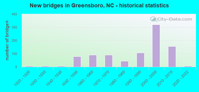
- New bridges - historical statistics
- 61920-1929
- 61930-1939
- 81940-1949
- 781950-1959
- 911960-1969
- 901970-1979
- 451980-1989
- 1081990-1999
- 3222000-2009
- 1552010-2019
- 62020-2022
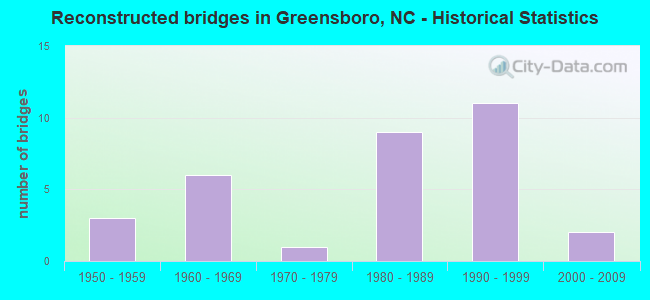
- Reconstructed bridges - Historical Statistics
- 31950-1959
- 61960-1969
- 11970-1979
- 91980-1989
- 111990-1999
- 22000-2009
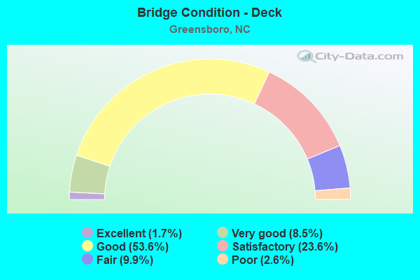
- Bridge Condition - Deck
- 1.7%Excellent
- 8.5%Very good
- 53.6%Good
- 23.6%Satisfactory
- 9.9%Fair
- 2.6%Poor
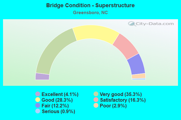
- Bridge Condition - Superstructure
- 4.1%Excellent
- 35.3%Very good
- 28.3%Good
- 16.3%Satisfactory
- 12.2%Fair
- 2.9%Poor
- 0.9%Serious
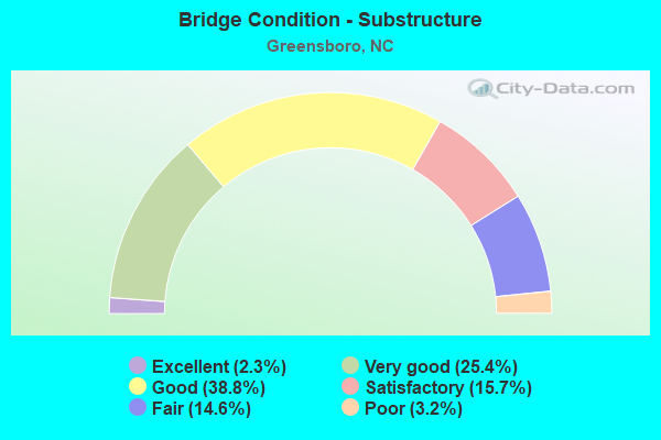
- Bridge Condition - Substructure
- 2.3%Excellent
- 25.4%Very good
- 38.8%Good
- 15.7%Satisfactory
- 14.6%Fair
- 3.2%Poor
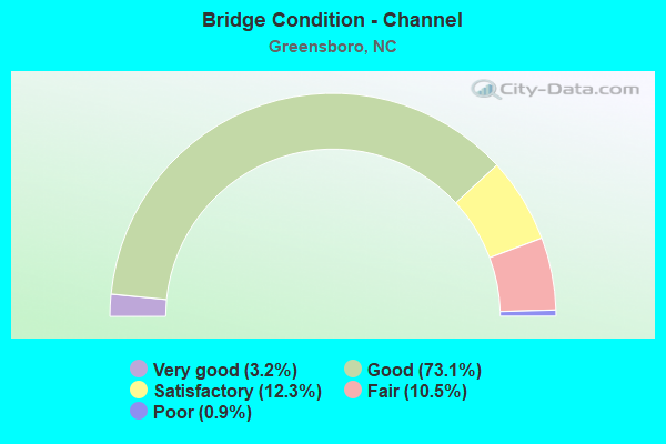
- Bridge Condition - Channel
- 3.2%Very good
- 73.1%Good
- 12.3%Satisfactory
- 10.5%Fair
- 0.9%Poor
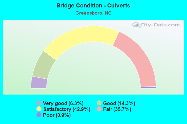
- Bridge Condition - Culverts
- 6.3%Very good
- 14.3%Good
- 42.9%Satisfactory
- 35.7%Fair
- 0.9%Poor
Find on map >> Show street view
Structure Number: 810397, Location: 100FT.N.JCT.BENJAMIN PKWY (Lat: 36.081406, Lng: -79.802611), Route carried "on" structure: City street , Year Built: 1961, Status: Open, Structure Length: 1.73m (5.68ft), Average Daily Traffic: 12,000 (year 2013), Truck Traffic: 7%, Average Future Daily Traffic: 24,000 (year 2040), Design Load: HS 20, Features Intersected: N.BUFFALO CREEK, Facility Carried by Structure: W.SMITH STREET
Minimum Vertical Clearance: 30+ m (98+ ft), Kilometerpoint: 0.000, Lanes on structure: 5, Owner: City or Municipal Highway Agency, Approaching Roadway Width: 16.7m (54.8ft), Skew: 1 degrees, Material/Design: Prestressed concrete, Design/Construction: Stringer/Multi-beam, Number Of Spans In Main Unit: 1, Length of Maximum Span: 16.7m (54.8ft), Curb or Sidewalk Widths: Left: 1.5m (4.9ft), Right: 1.5m (4.9ft), Curb-To-Curb Width: 17.6m (57.7ft), Out-to-Out Width: 21.2m (69.6ft)
Condition: Deck: Satisfactory, Superstructure: Good, Substructure: Satisfactory, Channel: Good, Operating Rating: 44.4 metric tons, Method Used To Determine Operating Rating: Field evaluation and documented engineering judgment, Inventory Rating: 26.3 metric tons, Method Used To Determine Inventory Rating: Field evaluation and documented engineering judgment, Structural Evaluation: Equal to present minimum criteria, Deck Geometry: High priority of replacement, Waterway Adequacy: Equal to present minimum criteria, Approach Roadway Alignment: Equal to present desirable criteria, Designated Inspection Frequency: Every 24 months, Inspection Date: Febuary 2020, Deck Structure Type: Concrete Cast-file-Place, Wearing Surface/Protective System: Wearing Surface: Bituminous
Find on map >> Show street view
Structure Number: 810398, Location: 50 FT.S.JCT.LATHAM DR. (Lat: 36.091331, Lng: -79.792931), Route carried "on" structure: City street , Year Built: 1925, Status: Open, Structure Length: 2.10m (6.89ft), Average Daily Traffic: 4,800 (year 2017), Truck Traffic: 7%, Average Future Daily Traffic: 9,600 (year 2040), Design Load: H 15, Features Intersected: NORTH BUFFALO CREEK, Facility Carried by Structure: CRIDLAND RD
Minimum Vertical Clearance: 30+ m (98+ ft), Kilometerpoint: 0.000, Lanes on structure: 2, Owner: City or Municipal Highway Agency, Approaching Roadway Width: 10.3m (33.8ft), Material/Design: Concrete, Design/Construction: Tee Beam, Number Of Spans In Main Unit: 3, Length of Maximum Span: 7.0m (23.0ft), Curb or Sidewalk Widths: Left: 0.0m, Right: 1.9m (6.2ft), Curb-To-Curb Width: 9.1m (29.9ft), Out-to-Out Width: 11.7m (38.4ft)
Condition: Deck: Satisfactory, Superstructure: Fair, Substructure: Satisfactory, Channel: Satisfactory, Operating Rating: 47.1 metric tons, Method Used To Determine Operating Rating: Load Factor (LF), Inventory Rating: 28.1 metric tons, Method Used To Determine Inventory Rating: Load Factor (LF), Structural Evaluation: Somewhat better than minimum adequacy, Deck Geometry: Meets minimum limits, Waterway Adequacy: Equal to present minimum criteria, Approach Roadway Alignment: Equal to present desirable criteria, Designated Inspection Frequency: Every 24 months, Inspection Date: Febuary 2020, Deck Structure Type: Concrete Cast-file-Place, Wearing Surface/Protective System: Wearing Surface: Bituminous
Find on map >> Show street view
Structure Number: 810399, Location: 0.4 MI.N.JCT.WENDOVER AVE (Lat: 36.094133, Lng: -79.788567), Route carried "on" structure: City street , Year Built: 1921, Status: Open, Structure Length: 2.68m (8.79ft), Average Daily Traffic: 15,000 (year 2017), Truck Traffic: 6%, Average Future Daily Traffic: 30,000 (year 2040), Design Load: H 10, Features Intersected: NORTH BUFFALO CREEK, Facility Carried by Structure: NORTH ELM STREET
Minimum Vertical Clearance: 30+ m (98+ ft), Kilometerpoint: 0.000, Lanes on structure: 2, Owner: City or Municipal Highway Agency, Approaching Roadway Width: 10.9m (35.8ft), Material/Design: Concrete, Design/Construction: Arch - Deck, Number Of Spans In Main Unit: 3, Length of Maximum Span: 9.7m (31.8ft), Curb or Sidewalk Widths: Left: 1.6m (5.2ft), Right: 1.6m (5.2ft), Curb-To-Curb Width: 11.0m (36.1ft), Out-to-Out Width: 14.8m (48.6ft)
Condition: Deck: Fair, Superstructure: Fair, Substructure: Poor, Channel: Fair, Operating Rating: 40.8 metric tons, Method Used To Determine Operating Rating: Load Factor (LF), Inventory Rating: 25.4 metric tons, Method Used To Determine Inventory Rating: Load Factor (LF), Structural Evaluation: Meets minimum limits, Deck Geometry: Meets minimum limits, Waterway Adequacy: Better than present minimum criteria, Approach Roadway Alignment: Equal to present desirable criteria, Designated Inspection Frequency: Every 24 months, Inspection Date: Febuary 2020, Deck Structure Type: Concrete Cast-file-Place, Wearing Surface/Protective System: Wearing Surface: Bituminous
Find on map >> Show street view
Structure Number: 8104, Location: .01 MI.E.JCT.AUTUMN DR. (Lat: 36.093217, Lng: -79.759944), Route carried "on" structure: City street , Year Built: 1958, Status: Posted for load, Structure Length: 1.31m (4.30ft), Average Daily Traffic: 800 (year 1998), Truck Traffic: 7%, Average Future Daily Traffic: 1,600 (year 2040), Design Load: HS 20, Features Intersected: MUDDY CREEK, Facility Carried by Structure: TEXTILE DRIVE
Minimum Vertical Clearance: 30+ m (98+ ft), Kilometerpoint: 0.000, Lanes on structure: 2, Owner: City or Municipal Highway Agency, Approaching Roadway Width: 10.9m (35.8ft), Skew: 1 degrees, Material/Design: Concrete continuous, Design/Construction: Culvert, Number Of Spans In Main Unit: 4, Length of Maximum Span: 3.3m (10.8ft), Curb or Sidewalk Widths: Left: 2.7m (8.9ft), Right: 2.7m (8.9ft), Curb-To-Curb Width: 11.0m (36.1ft), Out-to-Out Width: 17.2m (56.4ft)
Condition: Channel: Satisfactory, Culverts: Fair, Operating Rating: 41.7 metric tons, Method Used To Determine Operating Rating: Field evaluation and documented engineering judgment, Inventory Rating: 32.6 metric tons, Method Used To Determine Inventory Rating: Field evaluation and documented engineering judgment, Structural Evaluation: Somewhat better than minimum adequacy, Deck Geometry: Better than present minimum criteria, Waterway Adequacy: Better than present minimum criteria, Approach Roadway Alignment: Equal to present desirable criteria, Bridge Posting: Required (Relationship of Operating Rating to Maximum Legal Load: 20.0 - 29.9% below), Designated Inspection Frequency: Every 24 months, Inspection Date: Febuary 2020
Find on map >> Show street view
Structure Number: 810404, Location: 0.1 MI. W. JCT. SR1375 (Lat: 36.005567, Lng: -79.883803), Route carried "on" structure: State highway 1372, Year Built: 1956, Year Reconstructed: 1988, Status: Open, Structure Length: 0.70m (2.30ft), Average Daily Traffic: 2,100 (year 2017), Truck Traffic: 7%, Average Future Daily Traffic: 4,200 (year 2040), Features Intersected: REDDICKS CREEK
Minimum Vertical Clearance: 30+ m (98+ ft), Kilometerpoint: 0.000, Lanes on structure: 2, Owner: State Highway Agency, Approaching Roadway Width: 5.1m (16.7ft), Skew: 3 degrees, Material/Design: Steel, Design/Construction: Stringer/Multi-beam, Number Of Spans In Main Unit: 1, Length of Maximum Span: 6.0m (19.7ft), Curb-To-Curb Width: 6.8m (22.3ft), Out-to-Out Width: 6.9m (22.6ft)
Condition: Deck: Fair, Superstructure: Fair, Substructure: Fair, Channel: Satisfactory, Operating Rating: 55.3 metric tons, Method Used To Determine Operating Rating: Load Factor (LF), Inventory Rating: 32.6 metric tons, Method Used To Determine Inventory Rating: Load Factor (LF), Structural Evaluation: Somewhat better than minimum adequacy, Deck Geometry: High priority of replacement, Waterway Adequacy: Equal to present minimum criteria, Approach Roadway Alignment: Equal to present desirable criteria, Designated Inspection Frequency: Every 24 months, Inspection Date: July 2020, Deck Structure Type: Wood or Timber, Wearing Surface/Protective System: Wearing Surface: Bituminous
Find on map >> Show street view
Structure Number: 810406, Location: 0.15 MI.W. WENDOVER AVE. (Lat: 36.090386, Lng: -79.761556), Route carried "on" structure: City street , Year Built: 1957, Status: Open, Structure Length: 1.09m (3.58ft), Average Daily Traffic: 2,700 (year 1998), Truck Traffic: 7%, Average Future Daily Traffic: 5,400 (year 2040), Design Load: HS 20, Features Intersected: MUDDY CREEK, Facility Carried by Structure: GATEWOOD AVENUE
Minimum Vertical Clearance: 30+ m (98+ ft), Kilometerpoint: 0.000, Lanes on structure: 2, Owner: City or Municipal Highway Agency, Approaching Roadway Width: 8.5m (27.9ft), Skew: 1 degrees, Material/Design: Concrete continuous, Design/Construction: Culvert, Number Of Spans In Main Unit: 3, Length of Maximum Span: 3.3m (10.8ft)
Condition: Channel: Good, Culverts: Satisfactory, Operating Rating: 41.7 metric tons, Method Used To Determine Operating Rating: Field evaluation and documented engineering judgment, Inventory Rating: 32.6 metric tons, Method Used To Determine Inventory Rating: Field evaluation and documented engineering judgment, Structural Evaluation: Equal to present minimum criteria, Waterway Adequacy: Better than present minimum criteria, Approach Roadway Alignment: Equal to present desirable criteria, Designated Inspection Frequency: Every 24 months, Inspection Date: Febuary 2020
Find on map >> Show street view
Structure Number: 810408, Location: 0.7MI.S.JCT.BATTLEGROUND (Lat: 36.142747, Lng: -79.856739), Route carried "on" structure: City street , Year Built: 1979, Status: Open, Structure Length: 4.11m (13.48ft), Average Daily Traffic: 9,700 (year 2018), Truck Traffic: 7%, Average Future Daily Traffic: 19,400 (year 2040), Design Load: H 20, Features Intersected: HORSEPEN CREEK, Facility Carried by Structure: BATTLEGROUND RD
Minimum Vertical Clearance: 30+ m (98+ ft), Kilometerpoint: 0.000, Lanes on structure: 2, Owner: City or Municipal Highway Agency, Approaching Roadway Width: 8.8m (28.9ft), Material/Design: Prestressed concrete, Design/Construction: Slab, Number Of Spans In Main Unit: 3, Length of Maximum Span: 13.4m (44.0ft), Curb-To-Curb Width: 9.8m (32.2ft), Out-to-Out Width: 10.8m (35.4ft)
Condition: Deck: Fair, Superstructure: Fair, Substructure: Satisfactory, Channel: Satisfactory, Operating Rating: 34.4 metric tons, Method Used To Determine Operating Rating: Field evaluation and documented engineering judgment, Inventory Rating: 19.0 metric tons, Method Used To Determine Inventory Rating: Field evaluation and documented engineering judgment, Structural Evaluation: Meets minimum limits, Deck Geometry: Meets minimum limits, Waterway Adequacy: Better than present minimum criteria, Approach Roadway Alignment: Equal to present desirable criteria, Designated Inspection Frequency: Every 24 months, Inspection Date: Febuary 2020, Deck Structure Type: Concrete Precast Panels, Wearing Surface/Protective System: Wearing Surface: Bituminous
Find on map >> Show street view
Structure Number: 810412, Location: 0.25 MI N. JCT. SR2610 (Lat: 36.105256, Lng: -79.764525), Route carried "on" structure: State highway 2526, Year Built: 1939, Year Reconstructed: 1998, Status: Open, Structure Length: 2.40m (7.87ft), Average Daily Traffic: 14,500 (year 2019), Truck Traffic: 6%, Average Future Daily Traffic: 29,000 (year 2040), Design Load: H 15, Features Intersected: NORTH BUFFALO CREEK
Minimum Vertical Clearance: 30+ m (98+ ft), Kilometerpoint: 0.000, Lanes on structure: 5, Owner: State Highway Agency, Approaching Roadway Width: 18.8m (61.7ft), Material/Design: Concrete, Design/Construction: Tee Beam, Number Of Spans In Main Unit: 2, Length of Maximum Span: 11.2m (36.7ft), Curb or Sidewalk Widths: Left: 1.3m (4.3ft), Right: 0.0m, Curb-To-Curb Width: 17.7m (58.1ft), Out-to-Out Width: 21.1m (69.2ft)
Condition: Deck: Satisfactory, Superstructure: Fair, Substructure: Satisfactory, Channel: Satisfactory, Operating Rating: 25.4 metric tons, Method Used To Determine Operating Rating: Field evaluation and documented engineering judgment, Inventory Rating: 19.9 metric tons, Method Used To Determine Inventory Rating: Field evaluation and documented engineering judgment, Structural Evaluation: Somewhat better than minimum adequacy, Deck Geometry: High priority of replacement, Waterway Adequacy: Somewhat better than minimum adequacy, Approach Roadway Alignment: Equal to present desirable criteria, Designated Inspection Frequency: Every 24 months, Inspection Date: September 2020, Deck Structure Type: Concrete Cast-file-Place, Wearing Surface/Protective System: Wearing Surface: Bituminous
Find on map >> Show street view
Structure Number: 810414, Location: 0.15MI.E.JCT.O'HENRY BLV (Lat: 36.084808, Lng: -79.764683), Route carried "on" structure: City street , Year Built: 1949, Status: Open, Structure Length: 1.06m (3.48ft), Average Daily Traffic: 14,000 (year 2013), Truck Traffic: 7%, Average Future Daily Traffic: 28,000 (year 2025), Design Load: HS 20, Features Intersected: MUDDY CREEK, Facility Carried by Structure: BESSEMER AVE.
Minimum Vertical Clearance: 30+ m (98+ ft), Kilometerpoint: 0.000, Lanes on structure: 5, Owner: City or Municipal Highway Agency, Approaching Roadway Width: 19.8m (65.0ft), Material/Design: Concrete continuous, Design/Construction: Culvert, Number Of Spans In Main Unit: 3, Length of Maximum Span: 3.3m (10.8ft), Curb-To-Curb Width: 21.7m (71.2ft), Out-to-Out Width: 30.4m (99.7ft)
Condition: Channel: Good, Culverts: Fair, Operating Rating: 34.4 metric tons, Method Used To Determine Operating Rating: Load Factor (LF), Inventory Rating: 20.8 metric tons, Method Used To Determine Inventory Rating: Load Factor (LF), Structural Evaluation: Somewhat better than minimum adequacy, Deck Geometry: Somewhat better than minimum adequacy, Waterway Adequacy: Better than present minimum criteria, Approach Roadway Alignment: Equal to present desirable criteria, Designated Inspection Frequency: Every 24 months, Inspection Date: Febuary 2020
Find on map >> Show street view
Structure Number: 810416, Location: 0.25 MI. E. JCT.MLK JR DR (Lat: 36.047531, Lng: -79.770203), Route carried "on" structure: City street , Year Built: 1965, Status: Open, Structure Length: 0.85m (2.79ft), Average Daily Traffic: 1,000 (year 1998), Truck Traffic: 7%, Average Future Daily Traffic: 2,000 (year 2040), Design Load: HS 20+Mod, Features Intersected: STREAM OFF BUFFALO CREEK, Facility Carried by Structure: BOTHWELL STREET
Minimum Vertical Clearance: 30+ m (98+ ft), Kilometerpoint: 0.000, Lanes on structure: 2, Owner: City or Municipal Highway Agency, Approaching Roadway Width: 9.1m (29.9ft), Skew: 2 degrees, Material/Design: Steel, Design/Construction: Culvert, Number Of Spans In Main Unit: 2, Length of Maximum Span: 3.6m (11.8ft)
Condition: Channel: Good, Culverts: Fair, Operating Rating: 89.8 metric tons, Method Used To Determine Operating Rating: Load and Resistance Factor (LRFR), Inventory Rating: 89.8 metric tons, Method Used To Determine Inventory Rating: Load and Resistance Factor (LRFR), Structural Evaluation: Somewhat better than minimum adequacy, Waterway Adequacy: Better than present minimum criteria, Approach Roadway Alignment: Equal to present desirable criteria, Designated Inspection Frequency: Every 24 months, Inspection Date: Febuary 2020
Find on map >> Show street view
Structure Number: 810417, Location: .02 MI.W.JCT.S.SIDE BLVD. (Lat: 36.048628, Lng: -79.771428), Route carried "on" structure: City street , Year Built: 1964, Status: Open, Structure Length: 0.64m (2.10ft), Average Daily Traffic: 800 (year 1998), Truck Traffic: 7%, Average Future Daily Traffic: 1,600 (year 2040), Design Load: HS 20, Features Intersected: S. BUFFALO CREEK, Facility Carried by Structure: BRITTON STREET
Minimum Vertical Clearance: 30+ m (98+ ft), Kilometerpoint: 0.000, Lanes on structure: 2, Owner: City or Municipal Highway Agency, Approaching Roadway Width: 9.4m (30.8ft), Material/Design: Concrete continuous, Design/Construction: Culvert, Number Of Spans In Main Unit: 2, Length of Maximum Span: 3.0m (9.8ft), Curb or Sidewalk Widths: Left: 3.0m (9.8ft), Right: 3.0m (9.8ft), Curb-To-Curb Width: 9.1m (29.9ft), Out-to-Out Width: 15.9m (52.2ft)
Condition: Channel: Fair, Culverts: Fair, Operating Rating: 68.9 metric tons, Method Used To Determine Operating Rating: Load Factor (LF), Inventory Rating: 40.8 metric tons, Method Used To Determine Inventory Rating: Load Factor (LF), Structural Evaluation: Somewhat better than minimum adequacy, Deck Geometry: Equal to present minimum criteria, Waterway Adequacy: Better than present minimum criteria, Approach Roadway Alignment: Equal to present desirable criteria, Designated Inspection Frequency: Every 24 months, Inspection Date: Febuary 2020
Find on map >> Show street view
Structure Number: 810419, Location: 0.02MI.W.JCT.PICHARD ST. (Lat: 36.048656, Lng: -79.764647), Route carried "on" structure: City street , Year Built: 1950, Status: Open, Structure Length: 0.85m (2.79ft), Average Daily Traffic: 200 (year 1998), Truck Traffic: 7%, Average Future Daily Traffic: 400 (year 2040), Design Load: HS 20, Features Intersected: STREAM, Facility Carried by Structure: BOTHWELL STREET
Minimum Vertical Clearance: 30+ m (98+ ft), Kilometerpoint: 0.000, Lanes on structure: 2, Owner: City or Municipal Highway Agency, Approaching Roadway Width: 9.4m (30.8ft), Skew: 2 degrees, Material/Design: Steel, Design/Construction: Culvert, Number Of Spans In Main Unit: 2, Length of Maximum Span: 3.6m (11.8ft)
Condition: Channel: Good, Culverts: Satisfactory, Operating Rating: 65.3 metric tons, Method Used To Determine Operating Rating: Load and Resistance Factor (LRFR), Inventory Rating: 49.8 metric tons, Method Used To Determine Inventory Rating: Load and Resistance Factor (LRFR), Structural Evaluation: Equal to present minimum criteria, Waterway Adequacy: Better than present minimum criteria, Approach Roadway Alignment: Equal to present desirable criteria, Designated Inspection Frequency: Every 24 months, Inspection Date: Febuary 2020
Find on map >> Show street view
Structure Number: 81042, Location: 1.5 MI. E. JCT.EUGENE ST. (Lat: 36.054603, Lng: -79.767800), Route carried "on" structure: City street , Year Built: 1971, Status: Open, Structure Length: 7.62m (25.00ft), Average Daily Traffic: 4,800 (year 2019), Truck Traffic: 6%, Average Future Daily Traffic: 9,600 (year 2040), Design Load: HS 20+Mod, Features Intersected: US29,US70,US220, Facility Carried by Structure: FLORIDA STREET
Minimum Vertical Clearance: 30+ m (98+ ft), Kilometerpoint: 0.000, Lanes on structure: 2, Lanes under structure: 4, Owner: State Highway Agency, Approaching Roadway Width: 16.4m (53.8ft), Material/Design: Steel, Design/Construction: Stringer/Multi-beam, Number Of Spans In Main Unit: 3, Number Of Approach Spans: 2, Length of Maximum Span: 40.5m (132.9ft), Curb or Sidewalk Widths: Left: 1.5m (4.9ft), Right: 1.5m (4.9ft), Curb-To-Curb Width: 13.4m (44.0ft), Out-to-Out Width: 17.1m (56.1ft)
Condition: Deck: Fair, Superstructure: Fair, Substructure: Fair, Operating Rating: 51.7 metric tons, Method Used To Determine Operating Rating: Load Factor (LF), Inventory Rating: 30.8 metric tons, Method Used To Determine Inventory Rating: Load Factor (LF), Structural Evaluation: Somewhat better than minimum adequacy, Deck Geometry: Better than present minimum criteria, Underclear: Somewhat better than minimum adequacy, Approach Roadway Alignment: Equal to present desirable criteria, Designated Inspection Frequency: Every 24 months, Inspection Date: April 2021, Deck Structure Type: Concrete Cast-file-Place, Wearing Surface/Protective System: Wearing Surface: Monolithic Concrete
Find on map >> Show street view
Structure Number: 810423, Location: .05MI.E.JCT.ELM EUGENE ST (Lat: 36.048736, Lng: -79.790808), Route carried "on" structure: City street , Year Built: 1965, Status: Open, Structure Length: 1.40m (4.59ft), Average Daily Traffic: 11,000 (year 2017), Truck Traffic: 7%, Average Future Daily Traffic: 22,000 (year 2040), Design Load: H 20, Features Intersected: MILE RUN CREEK, Facility Carried by Structure: EAST FLORIDA ST.
Minimum Vertical Clearance: 30+ m (98+ ft), Kilometerpoint: 12.321, Lanes on structure: 5, Owner: City or Municipal Highway Agency, Approaching Roadway Width: 18.2m (59.7ft), Skew: 5 degrees, Material/Design: Concrete continuous, Design/Construction: Culvert, Number Of Spans In Main Unit: 2, Length of Maximum Span: 3.6m (11.8ft)
Condition: Channel: Satisfactory, Culverts: Fair, Operating Rating: 89.8 metric tons, Method Used To Determine Operating Rating: Load Factor (LF), Inventory Rating: 76.2 metric tons, Method Used To Determine Inventory Rating: Load Factor (LF), Structural Evaluation: Somewhat better than minimum adequacy, Waterway Adequacy: Equal to present minimum criteria, Approach Roadway Alignment: Equal to present desirable criteria, Designated Inspection Frequency: Every 24 months, Inspection Date: Febuary 2020
Find on map >> Show street view
Structure Number: 810424, Location: .05MI.S JCT.BENJAMIN PKWY (Lat: 36.084594, Lng: -79.821889), Route carried "on" structure: City street , Year Built: 1958, Status: Open, Structure Length: 1.85m (6.07ft), Average Daily Traffic: 3,000 (year 1998), Truck Traffic: 7%, Average Future Daily Traffic: 6,000 (year 2040), Design Load: HS 20, Features Intersected: NORTH BUFFALO CREEK, Facility Carried by Structure: N. ELAM AVENUE
Minimum Vertical Clearance: 30+ m (98+ ft), Kilometerpoint: 0.000, Lanes on structure: 3, Owner: City or Municipal Highway Agency, Approaching Roadway Width: 16.4m (53.8ft), Skew: 3 degrees, Material/Design: Steel, Design/Construction: Stringer/Multi-beam, Number Of Spans In Main Unit: 1, Length of Maximum Span: 17.9m (58.7ft), Curb or Sidewalk Widths: Left: 1.5m (4.9ft), Right: 1.5m (4.9ft), Curb-To-Curb Width: 14.6m (47.9ft), Out-to-Out Width: 18.2m (59.7ft)
Condition: Deck: Poor, Superstructure: Fair, Substructure: Fair, Channel: Satisfactory, Operating Rating: 71.6 metric tons, Method Used To Determine Operating Rating: Load Factor (LF), Inventory Rating: 41.7 metric tons, Method Used To Determine Inventory Rating: Load Factor (LF), Structural Evaluation: Somewhat better than minimum adequacy, Deck Geometry: Somewhat better than minimum adequacy, Waterway Adequacy: Better than present minimum criteria, Approach Roadway Alignment: Equal to present desirable criteria, Designated Inspection Frequency: Every 24 months, Inspection Date: Febuary 2020, Deck Structure Type: Concrete Cast-file-Place, Wearing Surface/Protective System: Wearing Surface: Bituminous
Find on map >> Show street view
Structure Number: 810426, Location: .05MI.E.JCT.BENJAMIN PKWY (Lat: 36.094917, Lng: -79.829394), Route carried "on" structure: City street , Year Built: 1965, Status: Open, Structure Length: 0.70m (2.30ft), Average Daily Traffic: 6,600 (year 2013), Truck Traffic: 7%, Average Future Daily Traffic: 13,200 (year 2040), Design Load: HS 20, Features Intersected: BR. OF BUFFALO CREEK, Facility Carried by Structure: W.CORNWALLIS DRIVE
Minimum Vertical Clearance: 30+ m (98+ ft), Kilometerpoint: 0.000, Lanes on structure: 2, Owner: City or Municipal Highway Agency, Approaching Roadway Width: 10.9m (35.8ft), Skew: 2 degrees, Material/Design: Concrete continuous, Design/Construction: Culvert, Number Of Spans In Main Unit: 2, Length of Maximum Span: 3.0m (9.8ft)
Condition: Channel: Good, Culverts: Fair, Operating Rating: 89.8 metric tons, Method Used To Determine Operating Rating: Load Factor (LF), Inventory Rating: 78.0 metric tons, Method Used To Determine Inventory Rating: Load Factor (LF), Structural Evaluation: Somewhat better than minimum adequacy, Waterway Adequacy: Better than present minimum criteria, Approach Roadway Alignment: Equal to present desirable criteria, Designated Inspection Frequency: Every 24 months, Inspection Date: Febuary 2020
Find on map >> Show street view
Structure Number: 81043, Location: 0.1 MI.S.JCT.FAIRWAY ST. (Lat: 36.088872, Lng: -79.833050), Route carried "on" structure: City street , Year Built: 1964, Status: Open, Structure Length: 0.76m (2.49ft), Average Daily Traffic: 1,200 (year 1998), Truck Traffic: 7%, Average Future Daily Traffic: 2,400 (year 2040), Design Load: HS 20, Features Intersected: STREAM, Facility Carried by Structure: PEMBROKE ROAD
Minimum Vertical Clearance: 30+ m (98+ ft), Kilometerpoint: 0.000, Lanes on structure: 4, Owner: City or Municipal Highway Agency, Approaching Roadway Width: 14.9m (48.9ft), Material/Design: Concrete continuous, Design/Construction: Culvert, Number Of Spans In Main Unit: 2, Length of Maximum Span: 3.6m (11.8ft), Curb or Sidewalk Widths: Left: 1.5m (4.9ft), Right: 1.5m (4.9ft), Curb-To-Curb Width: 13.5m (44.3ft), Out-to-Out Width: 21.7m (71.2ft)
Condition: Channel: Satisfactory, Culverts: Good, Operating Rating: 53.5 metric tons, Method Used To Determine Operating Rating: Load Factor (LF), Inventory Rating: 32.6 metric tons, Method Used To Determine Inventory Rating: Load Factor (LF), Structural Evaluation: Better than present minimum criteria, Deck Geometry: High priority of replacement, Waterway Adequacy: Better than present minimum criteria, Approach Roadway Alignment: Equal to present desirable criteria, Designated Inspection Frequency: Every 24 months, Inspection Date: Febuary 2020
Find on map >> Show street view
Structure Number: 810434, Location: 0.1MI.S.JCT.CORNWALLIS DR (Lat: 36.100033, Lng: -79.775103), Route carried "on" structure: City street , Year Built: 1958, Status: Posted for load, Structure Length: 2.89m (9.48ft), Average Daily Traffic: 16,000 (year 2017), Truck Traffic: 6%, Average Future Daily Traffic: 32,000 (year 2040), Design Load: HS 20, Features Intersected: NORTH BUFFALO CREEK, Facility Carried by Structure: YANCEYVILLE STREET
Minimum Vertical Clearance: 30+ m (98+ ft), Kilometerpoint: 0.000, Lanes on structure: 4, Owner: City or Municipal Highway Agency, Approaching Roadway Width: 16.4m (53.8ft), Skew: 1 degrees, Material/Design: Concrete, Design/Construction: Tee Beam, Number Of Spans In Main Unit: 2, Length of Maximum Span: 14.0m (45.9ft), Curb or Sidewalk Widths: Left: 1.5m (4.9ft), Right: 1.5m (4.9ft), Curb-To-Curb Width: 13.4m (44.0ft), Out-to-Out Width: 17.0m (55.8ft)
Condition: Deck: Satisfactory, Superstructure: Fair, Substructure: Satisfactory, Channel: Good, Operating Rating: 33.5 metric tons, Method Used To Determine Operating Rating: Load Factor (LF), Inventory Rating: 20.8 metric tons, Method Used To Determine Inventory Rating: Load Factor (LF), Structural Evaluation: Somewhat better than minimum adequacy, Deck Geometry: High priority of replacement, Waterway Adequacy: Better than present minimum criteria, Approach Roadway Alignment: Equal to present desirable criteria, Bridge Posting: Required (Relationship of Operating Rating to Maximum Legal Load: 10.0 - 19.9% below), Designated Inspection Frequency: Every 24 months, Inspection Date: Febuary 2020, Deck Structure Type: Concrete Cast-file-Place, Wearing Surface/Protective System: Wearing Surface: Bituminous
Find on map >> Show street view
Structure Number: 810435, Location: 0.07MI.S.JCT.WATER ST. (Lat: 36.101625, Lng: -79.773028), Route carried "on" structure: City street , Year Built: 1975, Status: Open, Structure Length: 2.43m (7.97ft), Average Daily Traffic: 1,500 (year 1998), Truck Traffic: 7%, Average Future Daily Traffic: 3,000 (year 2040), Design Load: HS 20, Features Intersected: NORTH BUFFALO CREEK, Facility Carried by Structure: FAIRVIEW STREET
Minimum Vertical Clearance: 30+ m (98+ ft), Kilometerpoint: 0.000, Lanes on structure: 2, Owner: City or Municipal Highway Agency, Approaching Roadway Width: 6.7m (22.0ft), Skew: 4 degrees, Material/Design: Steel, Design/Construction: Stringer/Multi-beam, Number Of Spans In Main Unit: 2, Length of Maximum Span: 11.5m (37.7ft), Curb or Sidewalk Widths: Left: 1.4m (4.6ft), Right: 0.3m (1.0ft), Curb-To-Curb Width: 7.3m (24.0ft), Out-to-Out Width: 9.9m (32.5ft)
Condition: Deck: Fair, Superstructure: Fair, Substructure: Good, Channel: Fair, Operating Rating: 59.8 metric tons, Method Used To Determine Operating Rating: Load and Resistance Factor (LRFR), Inventory Rating: 35.3 metric tons, Method Used To Determine Inventory Rating: Load and Resistance Factor (LRFR), Structural Evaluation: Somewhat better than minimum adequacy, Deck Geometry: Meets minimum limits, Waterway Adequacy: Somewhat better than minimum adequacy, Approach Roadway Alignment: Equal to present desirable criteria, Designated Inspection Frequency: Every 24 months, Inspection Date: Febuary 2020, Deck Structure Type: Concrete Cast-file-Place, Wearing Surface/Protective System: Wearing Surface: Monolithic Concrete
Find on map >> Show street view
Structure Number: 810436, Location: 0.03MI.W.JCT.SHARONBROOK (Lat: 36.097969, Lng: -79.756806), Route carried "on" structure: City street , Year Built: 1961, Status: Open, Structure Length: 1.00m (3.28ft), Average Daily Traffic: 10,000 (year 2015), Truck Traffic: 7%, Average Future Daily Traffic: 20,000 (year 2040), Design Load: HS 20, Features Intersected: MUDDY CREEK, Facility Carried by Structure: PHILLIPS AVENUE
Minimum Vertical Clearance: 30+ m (98+ ft), Kilometerpoint: 0.000, Lanes on structure: 3, Owner: City or Municipal Highway Agency, Approaching Roadway Width: 16.7m (54.8ft), Material/Design: Steel, Design/Construction: Stringer/Multi-beam, Number Of Spans In Main Unit: 1, Length of Maximum Span: 9.4m (30.8ft), Curb or Sidewalk Widths: Left: 1.5m (4.9ft), Right: 1.5m (4.9ft), Curb-To-Curb Width: 13.4m (44.0ft), Out-to-Out Width: 17.1m (56.1ft)
Condition: Deck: Satisfactory, Superstructure: Fair, Substructure: Fair, Channel: Good, Operating Rating: 81.6 metric tons, Method Used To Determine Operating Rating: Load Factor (LF), Inventory Rating: 48.9 metric tons, Method Used To Determine Inventory Rating: Load Factor (LF), Structural Evaluation: Somewhat better than minimum adequacy, Deck Geometry: Somewhat better than minimum adequacy, Waterway Adequacy: Better than present minimum criteria, Approach Roadway Alignment: Equal to present desirable criteria, Designated Inspection Frequency: Every 24 months, Inspection Date: Febuary 2020, Deck Structure Type: Concrete Cast-file-Place, Wearing Surface/Protective System: Wearing Surface: Bituminous
Find on map >> Show street view
Structure Number: 810437, Location: .02 MI.E.JCT.DREXEL RD. (Lat: 36.102208, Lng: -79.749328), Route carried "on" structure: City street , Year Built: 1960, Status: Open, Structure Length: 0.76m (2.49ft), Average Daily Traffic: 100 (year 2015), Truck Traffic: 7%, Average Future Daily Traffic: 200 (year 2040), Design Load: HS 20, Features Intersected: MUDDY CREEK, Facility Carried by Structure: LARK SPUR DRIVE
Minimum Vertical Clearance: 30+ m (98+ ft), Kilometerpoint: 0.000, Lanes on structure: 2, Owner: City or Municipal Highway Agency, Approaching Roadway Width: 12.1m (39.7ft), Material/Design: Concrete continuous, Design/Construction: Culvert, Number Of Spans In Main Unit: 2, Length of Maximum Span: 3.6m (11.8ft), Curb or Sidewalk Widths: Left: 1.5m (4.9ft), Right: 1.9m (6.2ft), Curb-To-Curb Width: 9.1m (29.9ft), Out-to-Out Width: 16.0m (52.5ft)
Condition: Channel: Satisfactory, Culverts: Fair, Operating Rating: 41.7 metric tons, Method Used To Determine Operating Rating: Load Factor (LF), Inventory Rating: 25.4 metric tons, Method Used To Determine Inventory Rating: Load Factor (LF), Structural Evaluation: Somewhat better than minimum adequacy, Deck Geometry: Better than present minimum criteria, Waterway Adequacy: Better than present minimum criteria, Approach Roadway Alignment: Equal to present desirable criteria, Designated Inspection Frequency: Every 24 months, Inspection Date: Febuary 2020
Find on map >> Show street view
Structure Number: 810438, Location: 0.01MI.S.JCT.MEADOWVIEW (Lat: 36.038606, Lng: -79.813644), Route carried "on" structure: City street , Year Built: 1962, Status: Open, Structure Length: 0.70m (2.30ft), Average Daily Traffic: 800 (year 1979), Truck Traffic: 7%, Average Future Daily Traffic: 1,600 (year 2040), Design Load: HS 20, Features Intersected: STREAM, Facility Carried by Structure: GLENHAVEN DRIVE
Minimum Vertical Clearance: 30+ m (98+ ft), Kilometerpoint: 0.000, Lanes on structure: 2, Owner: City or Municipal Highway Agency, Approaching Roadway Width: 9.1m (29.9ft), Material/Design: Concrete continuous, Design/Construction: Culvert, Number Of Spans In Main Unit: 2, Length of Maximum Span: 3.3m (10.8ft)
Condition: Channel: Satisfactory, Culverts: Satisfactory, Operating Rating: 89.8 metric tons, Method Used To Determine Operating Rating: Load Factor (LF), Inventory Rating: 89.8 metric tons, Method Used To Determine Inventory Rating: Load Factor (LF), Structural Evaluation: Equal to present minimum criteria, Waterway Adequacy: Better than present minimum criteria, Approach Roadway Alignment: Equal to present desirable criteria, Designated Inspection Frequency: Every 24 months, Inspection Date: Febuary 2020
Find on map >> Show street view
Structure Number: 81044, Location: 0.02MI.S.JCT.MURRYHILL RD (Lat: 36.043667, Lng: -79.831872), Route carried "on" structure: City street , Year Built: 1959, Status: Open, Structure Length: 1.18m (3.87ft), Average Daily Traffic: 4,700 (year 1998), Truck Traffic: 7%, Average Future Daily Traffic: 9,400 (year 2040), Design Load: HS 20, Features Intersected: SOUTH BUFFALO CREEK, Facility Carried by Structure: VANSTORY STREET
Minimum Vertical Clearance: 30+ m (98+ ft), Kilometerpoint: 0.000, Lanes on structure: 2, Owner: City or Municipal Highway Agency, Approaching Roadway Width: 12.4m (40.7ft), Skew: 1 degrees, Material/Design: Concrete continuous, Design/Construction: Culvert, Number Of Spans In Main Unit: 3, Length of Maximum Span: 3.6m (11.8ft), Curb or Sidewalk Widths: Left: 1.5m (4.9ft), Right: 0.0m, Curb-To-Curb Width: 12.4m (40.7ft), Out-to-Out Width: 18.9m (62.0ft)
Condition: Channel: Satisfactory, Culverts: Satisfactory, Operating Rating: 45.3 metric tons, Method Used To Determine Operating Rating: Load Factor (LF), Inventory Rating: 27.2 metric tons, Method Used To Determine Inventory Rating: Load Factor (LF), Structural Evaluation: Equal to present minimum criteria, Deck Geometry: Equal to present minimum criteria, Waterway Adequacy: Equal to present minimum criteria, Approach Roadway Alignment: Equal to present desirable criteria, Designated Inspection Frequency: Every 24 months, Inspection Date: Febuary 2020
Find on map >> Show street view
Structure Number: 810441, Location: .02MI.W.JCT.HARDIE STREET (Lat: 36.040814, Lng: -79.830158), Route carried "on" structure: City street , Year Built: 1976, Status: Open, Structure Length: 1.76m (5.77ft), Average Daily Traffic: 5,700 (year 2015), Truck Traffic: 7%, Average Future Daily Traffic: 11,400 (year 2040), Design Load: HS 20, Features Intersected: SOUTH BUFFALO CREEK, Facility Carried by Structure: MEADOWVIEW ROAD
Minimum Vertical Clearance: 30+ m (98+ ft), Kilometerpoint: 0.000, Lanes on structure: 2, Owner: City or Municipal Highway Agency, Approaching Roadway Width: 8.8m (28.9ft), Skew: 3 degrees, Material/Design: Concrete continuous, Design/Construction: Culvert, Number Of Spans In Main Unit: 4, Length of Maximum Span: 3.6m (11.8ft)
Condition: Channel: Satisfactory, Culverts: Good, Operating Rating: 43.5 metric tons, Method Used To Determine Operating Rating: Load Factor (LF), Inventory Rating: 25.4 metric tons, Method Used To Determine Inventory Rating: Load Factor (LF), Structural Evaluation: Equal to present minimum criteria, Waterway Adequacy: Better than present minimum criteria, Approach Roadway Alignment: Equal to present desirable criteria, Designated Inspection Frequency: Every 24 months, Inspection Date: Febuary 2020
Find on map >> Show street view
Structure Number: 810442, Location: .25MI.E.HIGH POINT BLVD. (Lat: 36.043250, Lng: -79.835722), Route carried "on" structure: City street , Year Built: 1976, Status: Open, Structure Length: 1.31m (4.30ft), Average Daily Traffic: 5,700 (year 2015), Truck Traffic: 7%, Average Future Daily Traffic: 11,400 (year 2040), Design Load: HS 20, Features Intersected: SOUTH BUFFALO CREEK, Facility Carried by Structure: MEADOWVIEW ROAD
Minimum Vertical Clearance: 30+ m (98+ ft), Kilometerpoint: 123.153, Lanes on structure: 2, Owner: City or Municipal Highway Agency, Approaching Roadway Width: 10.9m (35.8ft), Skew: 3 degrees, Material/Design: Concrete continuous, Design/Construction: Culvert, Number Of Spans In Main Unit: 3, Length of Maximum Span: 3.6m (11.8ft)
Condition: Channel: Fair, Culverts: Fair, Operating Rating: 41.7 metric tons, Method Used To Determine Operating Rating: Field evaluation and documented engineering judgment, Inventory Rating: 32.6 metric tons, Method Used To Determine Inventory Rating: Field evaluation and documented engineering judgment, Structural Evaluation: Somewhat better than minimum adequacy, Waterway Adequacy: Better than present minimum criteria, Approach Roadway Alignment: Equal to present desirable criteria, Designated Inspection Frequency: Every 24 months, Inspection Date: Febuary 2022
Find on map >> Show street view
Structure Number: 810443, Location: 0.25 MI.S.JCT.MEADOWV.DR. (Lat: 36.046364, Lng: -79.843225), Route carried "on" structure: City street , Year Built: 1945, Status: Open, Structure Length: 1.00m (3.28ft), Average Daily Traffic: 800 (year 1980), Truck Traffic: 7%, Average Future Daily Traffic: 1,600 (year 2040), Design Load: HS 20, Features Intersected: SOUTH BUFFALO CREEK, Facility Carried by Structure: MAPLEWOOD LANE
Minimum Vertical Clearance: 30+ m (98+ ft), Kilometerpoint: 0.000, Lanes on structure: 2, Owner: City or Municipal Highway Agency, Approaching Roadway Width: 5.1m (16.7ft), Material/Design: Concrete, Design/Construction: Tee Beam, Number Of Spans In Main Unit: 1, Length of Maximum Span: 9.4m (30.8ft), Curb or Sidewalk Widths: Left: 0.1m (0.3ft), Right: 0.1m (0.3ft), Curb-To-Curb Width: 7.0m (23.0ft), Out-to-Out Width: 8.0m (26.2ft)
Condition: Deck: Satisfactory, Superstructure: Satisfactory, Substructure: Fair, Channel: Satisfactory, Operating Rating: 25.4 metric tons, Method Used To Determine Operating Rating: Load Factor (LF), Inventory Rating: 19.9 metric tons, Method Used To Determine Inventory Rating: Load Factor (LF), Structural Evaluation: Somewhat better than minimum adequacy, Deck Geometry: Meets minimum limits, Waterway Adequacy: Somewhat better than minimum adequacy, Approach Roadway Alignment: Equal to present desirable criteria, Designated Inspection Frequency: Every 24 months, Inspection Date: Febuary 2020, Deck Structure Type: Concrete Cast-file-Place, Wearing Surface/Protective System: Wearing Surface: Bituminous
Find on map >> Show street view
Structure Number: 810444, Location: .10 MI.N.JCT.I40 (Lat: 36.047325, Lng: -79.848261), Route carried "on" structure: City street , Year Built: 1967, Year Reconstructed: 2000, Status: Open, Structure Length: 1.34m (4.40ft), Average Daily Traffic: 23,000 (year 2015), Truck Traffic: 6%, Average Future Daily Traffic: 46,000 (year 2040), Design Load: HS 20, Features Intersected: SOUTH BUFFALO CREEK, Facility Carried by Structure: SOUTH HOLDEN ROAD
Minimum Vertical Clearance: 30+ m (98+ ft), Kilometerpoint: 0.000, Lanes on structure: 6, Owner: City or Municipal Highway Agency, Approaching Roadway Width: 27.4m (89.9ft), Skew: 23 degrees, Material/Design: Concrete continuous, Design/Construction: Culvert, Number Of Spans In Main Unit: 3, Length of Maximum Span: 3.6m (11.8ft)
Condition: Channel: Fair, Culverts: Fair, Operating Rating: 41.7 metric tons, Method Used To Determine Operating Rating: Load Factor (LF), Inventory Rating: 32.6 metric tons, Method Used To Determine Inventory Rating: Field evaluation and documented engineering judgment, Structural Evaluation: Somewhat better than minimum adequacy, Waterway Adequacy: Better than present minimum criteria, Approach Roadway Alignment: Equal to present desirable criteria, Designated Inspection Frequency: Every 24 months, Inspection Date: Febuary 2020
Find on map >> Show street view
Structure Number: 810445, Location: 0.25MI.N.JCT.MARKET ST. (Lat: 36.076492, Lng: -79.847456), Route carried "on" structure: City street , Year Built: 1971, Status: Open, Structure Length: 0.94m (3.08ft), Average Daily Traffic: 8,000 (year 2013), Truck Traffic: 6%, Average Future Daily Traffic: 16,000 (year 2040), Features Intersected: STREAM, Facility Carried by Structure: NORTH HOLDEN ROAD
Minimum Vertical Clearance: 30+ m (98+ ft), Kilometerpoint: 0.000, Lanes on structure: 4, Owner: City or Municipal Highway Agency, Approaching Roadway Width: 16.1m (52.8ft), Skew: 23 degrees, Material/Design: Concrete continuous, Design/Construction: Culvert, Number Of Spans In Main Unit: 2, Length of Maximum Span: 3.6m (11.8ft)
Condition: Channel: Good, Culverts: Fair, Operating Rating: 41.7 metric tons, Method Used To Determine Operating Rating: Field evaluation and documented engineering judgment, Inventory Rating: 32.6 metric tons, Method Used To Determine Inventory Rating: Field evaluation and documented engineering judgment, Structural Evaluation: Somewhat better than minimum adequacy, Waterway Adequacy: Better than present minimum criteria, Approach Roadway Alignment: Equal to present desirable criteria, Designated Inspection Frequency: Every 24 months, Inspection Date: Febuary 2020
Find on map >> Show street view
Structure Number: 810446, Location: 0.4MI.N.JCT.FRIENDLY AVE. (Lat: 36.091678, Lng: -79.840839), Route carried "on" structure: City street , Year Built: 1966, Status: Open, Structure Length: 0.94m (3.08ft), Average Daily Traffic: 4,700 (year 2015), Truck Traffic: 7%, Average Future Daily Traffic: 9,400 (year 2040), Design Load: HS 20, Features Intersected: NORTH BUFFALO CREEK, Facility Carried by Structure: HOBBS ROAD
Minimum Vertical Clearance: 30+ m (98+ ft), Kilometerpoint: 0.000, Lanes on structure: 2, Owner: City or Municipal Highway Agency, Approaching Roadway Width: 11.2m (36.7ft), Skew: 24 degrees, Material/Design: Concrete continuous, Design/Construction: Culvert, Number Of Spans In Main Unit: 2, Length of Maximum Span: 3.0m (9.8ft), Curb or Sidewalk Widths: Left: 1.5m (4.9ft), Right: 1.5m (4.9ft), Curb-To-Curb Width: 10.9m (35.8ft), Out-to-Out Width: 14.9m (48.9ft)
Condition: Channel: Satisfactory, Culverts: Satisfactory, Operating Rating: 40.8 metric tons, Method Used To Determine Operating Rating: Load Factor (LF), Inventory Rating: 24.4 metric tons, Method Used To Determine Inventory Rating: Load Factor (LF), Structural Evaluation: Equal to present minimum criteria, Deck Geometry: Somewhat better than minimum adequacy, Waterway Adequacy: Better than present minimum criteria, Approach Roadway Alignment: Equal to present desirable criteria, Designated Inspection Frequency: Every 24 months, Inspection Date: Febuary 2020
Find on map >> Show street view
Structure Number: 810447, Location: 0.5 MI.E.JCT.US220 (Lat: 36.109081, Lng: -79.819897), Route carried "on" structure: City street , Year Built: 1966, Status: Open, Structure Length: 4.41m (14.47ft), Average Daily Traffic: 21,000 (year 2017), Truck Traffic: 6%, Average Future Daily Traffic: 42,000 (year 2040), Design Load: HS 15, Features Intersected: LAWNDALE DRIVE, Facility Carried by Structure: WEST CONE BLVD.
Minimum Vertical Clearance: 30+ m (98+ ft), Kilometerpoint: 0.000, Lanes on structure: 6, Lanes under structure: 4, Owner: City or Municipal Highway Agency, Approaching Roadway Width: 17.0m (55.8ft), Skew: 20 degrees, Material/Design: Steel, Design/Construction: Stringer/Multi-beam, Number Of Spans In Main Unit: 3, Length of Maximum Span: 21.0m (68.9ft), Curb or Sidewalk Widths: Left: 2.1m (6.9ft), Right: 2.1m (6.9ft), Curb-To-Curb Width: 22.5m (73.8ft), Out-to-Out Width: 27.5m (90.2ft)
Condition: Deck: Satisfactory, Superstructure: Satisfactory, Substructure: Satisfactory, Operating Rating: 49.8 metric tons, Method Used To Determine Operating Rating: Load Factor (LF), Inventory Rating: 29.0 metric tons, Method Used To Determine Inventory Rating: Load Factor (LF), Structural Evaluation: Equal to present minimum criteria, Deck Geometry: Meets minimum limits, Underclear: Meets minimum limits, Approach Roadway Alignment: Equal to present desirable criteria, Designated Inspection Frequency: Every 24 months, Inspection Date: Febuary 2020, Deck Structure Type: Concrete Cast-file-Place, Wearing Surface/Protective System: Wearing Surface: Bituminous
Find on map >> Show street view
Structure Number: 810448, Location: @ JCT.WEST CONE BLVD. (Lat: 36.109236, Lng: -79.810958), Route carried "on" structure: City street , Year Built: 1957, Status: Open, Structure Length: 0.67m (2.20ft), Average Daily Traffic: 900 (year 1998), Truck Traffic: 7%, Average Future Daily Traffic: 1,800 (year 2040), Design Load: HS 20+Mod, Features Intersected: STREAM, Facility Carried by Structure: ELKHART DR/HOLLY D
Minimum Vertical Clearance: 30+ m (98+ ft), Kilometerpoint: 0.000, Lanes on structure: 2, Owner: City or Municipal Highway Agency, Approaching Roadway Width: 9.4m (30.8ft), Material/Design: Concrete continuous, Design/Construction: Culvert, Number Of Spans In Main Unit: 2, Length of Maximum Span: 3.3m (10.8ft), Curb or Sidewalk Widths: Left: 3.0m (9.8ft), Right: 3.0m (9.8ft), Curb-To-Curb Width: 9.1m (29.9ft), Out-to-Out Width: 15.8m (51.8ft)
Condition: Channel: Good, Culverts: Satisfactory, Operating Rating: 40.8 metric tons, Method Used To Determine Operating Rating: Load Factor (LF), Inventory Rating: 24.4 metric tons, Method Used To Determine Inventory Rating: Load Factor (LF), Structural Evaluation: Equal to present minimum criteria, Deck Geometry: Equal to present minimum criteria, Waterway Adequacy: Better than present minimum criteria, Approach Roadway Alignment: Equal to present desirable criteria, Designated Inspection Frequency: Every 24 months, Inspection Date: Febuary 2020
Find on map >> Show street view
Structure Number: 81045, Location: @ INTER.W.CONE BLVD. (Lat: 36.108156, Lng: -79.807758), Route carried "on" structure: City street , Year Built: 1957, Status: Open, Structure Length: 0.67m (2.20ft), Average Daily Traffic: 900 (year 1998), Truck Traffic: 7%, Average Future Daily Traffic: 1,800 (year 2040), Design Load: HS 20+Mod, Features Intersected: STREAM, Facility Carried by Structure: LAFEYETTE AVE.
Minimum Vertical Clearance: 30+ m (98+ ft), Kilometerpoint: 0.000, Lanes on structure: 2, Owner: City or Municipal Highway Agency, Approaching Roadway Width: 10.3m (33.8ft), Material/Design: Concrete continuous, Design/Construction: Culvert, Number Of Spans In Main Unit: 2, Length of Maximum Span: 3.3m (10.8ft), Curb-To-Curb Width: 10.4m (34.1ft), Out-to-Out Width: 15.8m (51.8ft)
Condition: Channel: Good, Culverts: Satisfactory, Operating Rating: 40.8 metric tons, Method Used To Determine Operating Rating: Load Factor (LF), Inventory Rating: 24.4 metric tons, Method Used To Determine Inventory Rating: Load Factor (LF), Structural Evaluation: Equal to present minimum criteria, Deck Geometry: Equal to present minimum criteria, Waterway Adequacy: Better than present minimum criteria, Approach Roadway Alignment: Equal to present desirable criteria, Designated Inspection Frequency: Every 24 months, Inspection Date: Febuary 2020
Find on map >> Show street view
Structure Number: 810451, Location: 1.5MI.E.JCT.US220 NORTH (Lat: 36.106117, Lng: -79.803747), Route carried "on" structure: City street , Year Built: 1960, Status: Open, Structure Length: 1.31m (4.30ft), Average Daily Traffic: 20,000 (year 2018), Truck Traffic: 6%, Average Future Daily Traffic: 40,000 (year 2040), Design Load: HS 20+Mod, Features Intersected: STREAM, Facility Carried by Structure: WEST CONE BLVD
Minimum Vertical Clearance: 30+ m (98+ ft), Kilometerpoint: 0.000, Lanes on structure: 2, Owner: City or Municipal Highway Agency, Approaching Roadway Width: 7.6m (24.9ft), Skew: 4 degrees, Material/Design: Concrete continuous, Design/Construction: Culvert, Number Of Spans In Main Unit: 3, Length of Maximum Span: 3.0m (9.8ft)
Condition: Channel: Fair, Culverts: Satisfactory, Operating Rating: 51.7 metric tons, Method Used To Determine Operating Rating: Load Factor (LF), Inventory Rating: 29.0 metric tons, Method Used To Determine Inventory Rating: Load Factor (LF), Structural Evaluation: Equal to present minimum criteria, Waterway Adequacy: Better than present minimum criteria, Approach Roadway Alignment: Equal to present desirable criteria, Designated Inspection Frequency: Every 24 months, Inspection Date: Febuary 2020
Find on map >> Show street view
Structure Number: 810452, Location: 250FT.N.JCT.W.CONE BLVD. (Lat: 36.108636, Lng: -79.797222), Route carried "on" structure: City street , Year Built: 1960, Status: Open, Structure Length: 1.06m (3.48ft), Average Daily Traffic: 500 (year 1998), Truck Traffic: 7%, Average Future Daily Traffic: 1,000 (year 2040), Design Load: HS 20+Mod, Features Intersected: PHILADELPHIA BUFFALO LAK, Facility Carried by Structure: MARSTONROAD
Minimum Vertical Clearance: 30+ m (98+ ft), Kilometerpoint: 0.000, Lanes on structure: 2, Owner: City or Municipal Highway Agency, Approaching Roadway Width: 9.1m (29.9ft), Material/Design: Concrete continuous, Design/Construction: Culvert, Number Of Spans In Main Unit: 3, Length of Maximum Span: 3.3m (10.8ft)
Condition: Channel: Good, Culverts: Good, Operating Rating: 41.7 metric tons, Method Used To Determine Operating Rating: Field evaluation and documented engineering judgment, Inventory Rating: 32.6 metric tons, Method Used To Determine Inventory Rating: Field evaluation and documented engineering judgment, Structural Evaluation: Better than present minimum criteria, Waterway Adequacy: Somewhat better than minimum adequacy, Approach Roadway Alignment: Equal to present desirable criteria, Designated Inspection Frequency: Every 24 months, Underwater Inspection Frequency: Every 60 months, Inspection Date: October 2020, Underwater Inspection Date: October 2020
Find on map >> Show street view
Structure Number: 810453, Location: .01 MI.W.YANCEYVILLE ST. (Lat: 36.112806, Lng: -79.776664), Route carried "on" structure: City street , Year Built: 1960, Status: Open, Structure Length: 1.21m (3.97ft), Average Daily Traffic: 26,000 (year 2018), Truck Traffic: 7%, Average Future Daily Traffic: 52,000 (year 2040), Design Load: HS 20, Features Intersected: PRONG OF N.BUFFALO CREEK, Facility Carried by Structure: E. CONE BLVD.
Minimum Vertical Clearance: 30+ m (98+ ft), Kilometerpoint: 0.000, Lanes on structure: 4, Owner: City or Municipal Highway Agency, Approaching Roadway Width: 15.8m (51.8ft), Skew: 23 degrees, Material/Design: Concrete continuous, Design/Construction: Culvert, Number Of Spans In Main Unit: 3, Length of Maximum Span: 3.3m (10.8ft)
Condition: Channel: Satisfactory, Culverts: Satisfactory, Operating Rating: 41.7 metric tons, Method Used To Determine Operating Rating: Field evaluation and documented engineering judgment, Inventory Rating: 32.6 metric tons, Method Used To Determine Inventory Rating: Field evaluation and documented engineering judgment, Structural Evaluation: Equal to present minimum criteria, Waterway Adequacy: Better than present minimum criteria, Approach Roadway Alignment: Equal to present desirable criteria, Designated Inspection Frequency: Every 24 months, Inspection Date: Febuary 2020
Find on map >> Show street view
Structure Number: 810454, Location: 0.1 MI.S.JCT.E.CONE BLVD. (Lat: 36.111992, Lng: -79.775511), Route carried "on" structure: City street , Year Built: 1965, Status: Open, Structure Length: 1.21m (3.97ft), Average Daily Traffic: 12,000 (year 2018), Truck Traffic: 7%, Average Future Daily Traffic: 24,000 (year 2040), Design Load: HS 20+Mod, Features Intersected: PRONG N.BUFFALO CRK., Facility Carried by Structure: YANCEYVILLE STREET
Minimum Vertical Clearance: 30+ m (98+ ft), Kilometerpoint: 0.000, Lanes on structure: 4, Owner: City or Municipal Highway Agency, Approaching Roadway Width: 13.7m (44.9ft), Skew: 23 degrees, Material/Design: Concrete continuous, Design/Construction: Culvert, Number Of Spans In Main Unit: 3, Length of Maximum Span: 3.3m (10.8ft)
Condition: Channel: Fair, Culverts: Fair, Operating Rating: 40.8 metric tons, Method Used To Determine Operating Rating: Load Factor (LF), Inventory Rating: 24.4 metric tons, Method Used To Determine Inventory Rating: Load Factor (LF), Structural Evaluation: Somewhat better than minimum adequacy, Waterway Adequacy: Better than present minimum criteria, Approach Roadway Alignment: Equal to present desirable criteria, Designated Inspection Frequency: Every 24 months, Inspection Date: Febuary 2020
Find on map >> Show street view
Structure Number: 810455, Location: 0.1 MI.W.JCT. SR2526 (Lat: 36.108608, Lng: -79.767050), Route carried "on" structure: City street , Year Built: 1958, Status: Open, Structure Length: 1.85m (6.07ft), Average Daily Traffic: 8,000 (year 2018), Truck Traffic: 7%, Average Future Daily Traffic: 16,000 (year 2040), Design Load: HS 20, Features Intersected: PRONG N. BUFFALO CREEK, Facility Carried by Structure: 16TH STREET
Minimum Vertical Clearance: 30+ m (98+ ft), Kilometerpoint: 0.000, Lanes on structure: 4, Owner: City or Municipal Highway Agency, Approaching Roadway Width: 12.8m (42.0ft), Material/Design: Steel, Design/Construction: Stringer/Multi-beam, Number Of Spans In Main Unit: 1, Length of Maximum Span: 17.6m (57.7ft), Curb or Sidewalk Widths: Left: 1.5m (4.9ft), Right: 1.5m (4.9ft), Curb-To-Curb Width: 12.8m (42.0ft), Out-to-Out Width: 16.4m (53.8ft)
Condition: Deck: Satisfactory, Superstructure: Satisfactory, Substructure: Fair, Channel: Good, Operating Rating: 74.3 metric tons, Method Used To Determine Operating Rating: Load Factor (LF), Inventory Rating: 43.5 metric tons, Method Used To Determine Inventory Rating: Load Factor (LF), Structural Evaluation: Somewhat better than minimum adequacy, Deck Geometry: High priority of replacement, Waterway Adequacy: Better than present minimum criteria, Approach Roadway Alignment: Equal to present desirable criteria, Designated Inspection Frequency: Every 24 months, Inspection Date: Febuary 2020, Deck Structure Type: Concrete Cast-file-Place, Wearing Surface/Protective System: Wearing Surface: Bituminous
Find on map >> Show street view
Structure Number: 810456, Location: 1.2 MI. N. JCT. SR2124 (Lat: 36.140228, Lng: -79.913892), Route carried "on" structure: State highway 2136, Year Built: 2018, Status: Open, Structure Length: 2.65m (8.69ft), Average Daily Traffic: 5,500 (year 2019), Truck Traffic: 7%, Average Future Daily Traffic: 11,000 (year 2040), Design Load: HL 93, Features Intersected: BRUSH CREEK
Minimum Vertical Clearance: 30+ m (98+ ft), Kilometerpoint: 0.000, Lanes on structure: 2, Owner: State Highway Agency, Approaching Roadway Width: 7.3m (24.0ft), Material/Design: Prestressed concrete, Design/Construction: Box Beam or Girders - Multiple, Number Of Spans In Main Unit: 1, Length of Maximum Span: 25.6m (84.0ft), Curb-To-Curb Width: 11.8m (38.7ft), Out-to-Out Width: 12.8m (42.0ft)
Condition: Deck: Very good, Superstructure: Very good, Substructure: Very good, Channel: Very good, Operating Rating: 83.4 metric tons, Method Used To Determine Operating Rating: Load and Resistance Factor (LRFR), Inventory Rating: 58.0 metric tons, Method Used To Determine Inventory Rating: Load and Resistance Factor (LRFR), Structural Evaluation: Equal to present desirable criteria, Deck Geometry: Somewhat better than minimum adequacy, Waterway Adequacy: Better than present minimum criteria, Approach Roadway Alignment: Equal to present desirable criteria, Designated Inspection Frequency: Every 24 months, Inspection Date: December 2020, Deck Structure Type: Concrete Precast Panels, Wearing Surface/Protective System: Wearing Surface: Bituminous
Find on map >> Show street view
Structure Number: 810458, Location: 0.7 MI. N. JCT. SR2335 (Lat: 36.170853, Lng: -79.837292), Route carried "on" structure: State highway 2347, Year Built: 1960, Status: Open, Structure Length: 6.88m (22.57ft), Average Daily Traffic: 10,000 (year 2019), Truck Traffic: 6%, Average Future Daily Traffic: 20,000 (year 2040), Design Load: HS 20+Mod, Features Intersected: LAKE BRANDT SPILLWAY
Minimum Vertical Clearance: 30+ m (98+ ft), Kilometerpoint: 0.000, Lanes on structure: 2, Owner: State Highway Agency, Approaching Roadway Width: 7.3m (24.0ft), Material/Design: Prestressed concrete, Design/Construction: Stringer/Multi-beam, Number Of Spans In Main Unit: 4, Length of Maximum Span: 17.0m (55.8ft), Curb or Sidewalk Widths: Left: 0.7m (2.3ft), Right: 0.7m (2.3ft), Curb-To-Curb Width: 7.3m (24.0ft), Out-to-Out Width: 9.4m (30.8ft)
Condition: Deck: Good, Superstructure: Satisfactory, Substructure: Satisfactory, Channel: Good, Operating Rating: 33.5 metric tons, Method Used To Determine Operating Rating: Field evaluation and documented engineering judgment, Inventory Rating: 19.9 metric tons, Method Used To Determine Inventory Rating: Field evaluation and documented engineering judgment, Structural Evaluation: Somewhat better than minimum adequacy, Deck Geometry: High priority of replacement, Waterway Adequacy: Equal to present desirable criteria, Approach Roadway Alignment: Equal to present desirable criteria, Designated Inspection Frequency: Every 24 months, Underwater Inspection Frequency: Every 60 months, Inspection Date: August 2020, Underwater Inspection Date: August 2021, Deck Structure Type: Concrete Cast-file-Place, Wearing Surface/Protective System: Wearing Surface: Bituminous
Find on map >> Show street view
Structure Number: 810459, Location: 0.4 MI. N. JCT. SR2790 (Lat: 36.181500, Lng: -79.708708), Route carried "on" structure: State highway 2526, Year Built: 1961, Year Reconstructed: 2001, Status: Open, Structure Length: 7.65m (25.10ft), Average Daily Traffic: 8,000 (year 2017), Truck Traffic: 7%, Average Future Daily Traffic: 16,000 (year 2040), Design Load: H 15, Features Intersected: REEDY FORK CREEK
Minimum Vertical Clearance: 30+ m (98+ ft), Kilometerpoint: 0.000, Lanes on structure: 2, Owner: State Highway Agency, Approaching Roadway Width: 7.6m (24.9ft), Material/Design: Prestressed concrete, Design/Construction: Stringer/Multi-beam, Number Of Spans In Main Unit: 5, Number Of Approach Spans: 2, Length of Maximum Span: 14.9m (48.9ft), Curb-To-Curb Width: 7.9m (25.9ft), Out-to-Out Width: 8.8m (28.9ft)
Condition: Deck: Satisfactory, Superstructure: Fair, Substructure: Good, Channel: Good, Operating Rating: 77.1 metric tons, Method Used To Determine Operating Rating: Load Factor (LF), Inventory Rating: 33.5 metric tons, Method Used To Determine Inventory Rating: Load Factor (LF), Structural Evaluation: Somewhat better than minimum adequacy, Deck Geometry: High priority of corrective action, Waterway Adequacy: Equal to present minimum criteria, Approach Roadway Alignment: Equal to present desirable criteria, Designated Inspection Frequency: Every 24 months, Inspection Date: March 2020, Deck Structure Type: Concrete Cast-file-Place, Wearing Surface/Protective System: Wearing Surface: Monolithic Concrete, Deck Protection: Epoxy Coated Reinforcing
Find on map >> Show street view
Structure Number: 810461, Location: 0.2 MI.W.JCT.SUMMIT AVE. (Lat: 36.079342, Lng: -79.785728), Route carried "on" structure: City street , Year Built: 1967, Status: Posted for load, Structure Length: 4.41m (14.47ft), Average Daily Traffic: 3,800 (year 2017), Truck Traffic: 6%, Average Future Daily Traffic: 7,600 (year 2040), Design Load: HS 15, Features Intersected: SOUTHERN RAILROAD, Facility Carried by Structure: MURROW BLVD.
Minimum Vertical Clearance: 30+ m (98+ ft), Kilometerpoint: 0.000, Lanes on structure: 5, Owner: City or Municipal Highway Agency, Approaching Roadway Width: 25.2m (82.7ft), Skew: 20 degrees, Material/Design: Steel, Design/Construction: Stringer/Multi-beam, Number Of Spans In Main Unit: 3, Length of Maximum Span: 15.8m (51.8ft), Curb or Sidewalk Widths: Left: 0.5m (1.6ft), Right: 0.5m (1.6ft), Curb-To-Curb Width: 26.9m (88.3ft), Out-to-Out Width: 29.8m (97.8ft)
Condition: Deck: Fair, Superstructure: Fair, Substructure: Satisfactory, Operating Rating: 57.1 metric tons, Method Used To Determine Operating Rating: Load Factor (LF), Inventory Rating: 33.5 metric tons, Method Used To Determine Inventory Rating: Load Factor (LF), Structural Evaluation: Somewhat better than minimum adequacy, Deck Geometry: Superior to present desirable criteria, Underclear: Better than present minimum criteria, Approach Roadway Alignment: Equal to present desirable criteria, Designated Inspection Frequency: Every 24 months, Inspection Date: Febuary 2020, Deck Structure Type: Concrete Cast-file-Place, Wearing Surface/Protective System: Wearing Surface: Monolithic Concrete
Find on map >> Show street view
Structure Number: 810462, Location: 0.3 MI.W.JCT.SUMMIT AVE. (Lat: 36.079278, Lng: -79.786625), Route carried "on" structure: City street , Year Built: 1967, Status: Open, Structure Length: 2.31m (7.58ft), Average Daily Traffic: 7,600 (year 2018), Truck Traffic: 6%, Average Future Daily Traffic: 15,200 (year 2040), Design Load: HS 15, Features Intersected: CHURCH STREET, Facility Carried by Structure: MURROW BLVD.
Minimum Vertical Clearance: 30+ m (98+ ft), Kilometerpoint: 0.000, Lanes on structure: 5, Lanes under structure: 3, Owner: City or Municipal Highway Agency, Approaching Roadway Width: 26.8m (87.9ft), Skew: 22 degrees, Material/Design: Steel, Design/Construction: Stringer/Multi-beam, Number Of Spans In Main Unit: 1, Length of Maximum Span: 22.8m (74.8ft), Curb or Sidewalk Widths: Left: 0.4m (1.3ft), Right: 0.4m (1.3ft), Curb-To-Curb Width: 26.8m (87.9ft), Out-to-Out Width: 29.5m (96.8ft)
Condition: Deck: Fair, Superstructure: Satisfactory, Substructure: Fair, Operating Rating: 82.5 metric tons, Method Used To Determine Operating Rating: Load Factor (LF), Inventory Rating: 48.9 metric tons, Method Used To Determine Inventory Rating: Load Factor (LF), Structural Evaluation: Somewhat better than minimum adequacy, Deck Geometry: Superior to present desirable criteria, Underclear: Meets minimum limits, Approach Roadway Alignment: Equal to present desirable criteria, Designated Inspection Frequency: Every 24 months, Inspection Date: Febuary 2020, Deck Structure Type: Concrete Cast-file-Place, Wearing Surface/Protective System: Wearing Surface: Bituminous
Find on map >> Show street view
Structure Number: 810464, Location: 0.2 MI. N. JCT. I85 (Lat: 36.037794, Lng: -79.800086), Route carried "on" structure: State highway 1007, Year Built: 1957, Year Reconstructed: 1972, Status: Open, Structure Length: 2.59m (8.50ft), Average Daily Traffic: 31,000 (year 2019), Truck Traffic: 6%, Average Future Daily Traffic: 62,000 (year 2040), Design Load: HS 20+Mod, Features Intersected: SOUTH BUFFALO CREEK
Minimum Vertical Clearance: 30+ m (98+ ft), Kilometerpoint: 0.000, Lanes on structure: 5, Owner: State Highway Agency, Approaching Roadway Width: 23.1m (75.8ft), Material/Design: Concrete, Design/Construction: Tee Beam, Number Of Spans In Main Unit: 2, Length of Maximum Span: 12.1m (39.7ft), Curb or Sidewalk Widths: Left: 1.5m (4.9ft), Right: 1.5m (4.9ft), Curb-To-Curb Width: 21.9m (71.9ft), Out-to-Out Width: 25.7m (84.3ft)
Condition: Deck: Satisfactory, Superstructure: Fair, Substructure: Fair, Channel: Good, Operating Rating: 43.5 metric tons, Method Used To Determine Operating Rating: Load Factor (LF), Inventory Rating: 26.3 metric tons, Method Used To Determine Inventory Rating: Load Factor (LF), Structural Evaluation: Somewhat better than minimum adequacy, Deck Geometry: Somewhat better than minimum adequacy, Waterway Adequacy: Better than present minimum criteria, Approach Roadway Alignment: Equal to present desirable criteria, Designated Inspection Frequency: Every 24 months, Inspection Date: October 2020, Deck Structure Type: Concrete Cast-file-Place, Wearing Surface/Protective System: Wearing Surface: Bituminous