Bridge Statistics for Greensboro, North Carolina (NC)
Condition, Traffic, Stress, Structural Evaluation, Project Costs
- National Bridge Inventory (NBI) Statistics
- 915Number of bridges
- 8,940ft / 2,725mTotal length
- 17,213,464Total average daily traffic
- 2,291,506Total average daily truck traffic
- National Bridge Inventory (NBI) Registered Bridges for Greensboro
- No street view available for this location
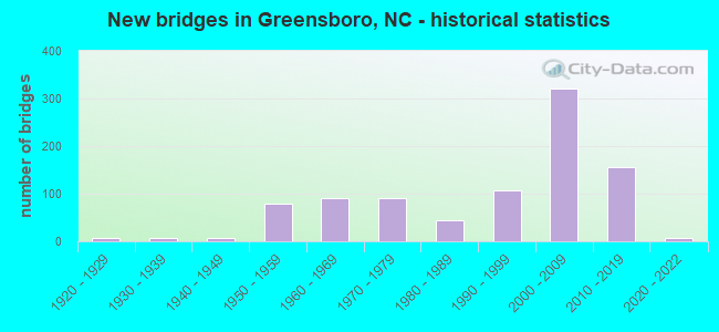
- New bridges - historical statistics
- 61920-1929
- 61930-1939
- 81940-1949
- 781950-1959
- 911960-1969
- 901970-1979
- 451980-1989
- 1081990-1999
- 3222000-2009
- 1552010-2019
- 62020-2022
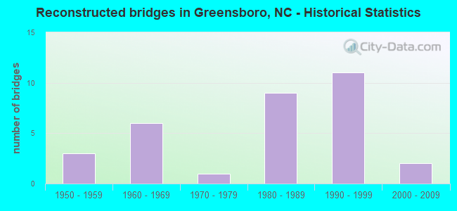
- Reconstructed bridges - Historical Statistics
- 31950-1959
- 61960-1969
- 11970-1979
- 91980-1989
- 111990-1999
- 22000-2009
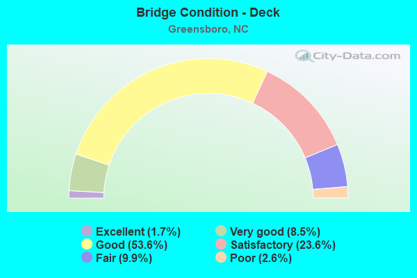
- Bridge Condition - Deck
- 1.7%Excellent
- 8.5%Very good
- 53.6%Good
- 23.6%Satisfactory
- 9.9%Fair
- 2.6%Poor
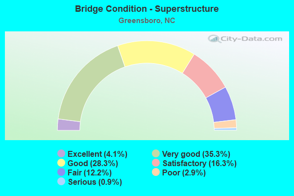
- Bridge Condition - Superstructure
- 4.1%Excellent
- 35.3%Very good
- 28.3%Good
- 16.3%Satisfactory
- 12.2%Fair
- 2.9%Poor
- 0.9%Serious
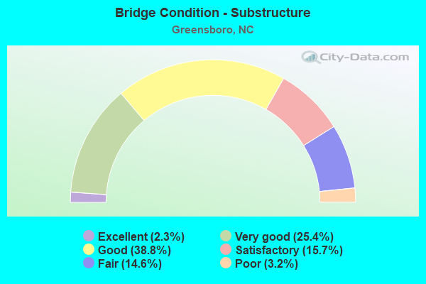
- Bridge Condition - Substructure
- 2.3%Excellent
- 25.4%Very good
- 38.8%Good
- 15.7%Satisfactory
- 14.6%Fair
- 3.2%Poor
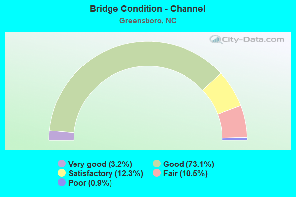
- Bridge Condition - Channel
- 3.2%Very good
- 73.1%Good
- 12.3%Satisfactory
- 10.5%Fair
- 0.9%Poor
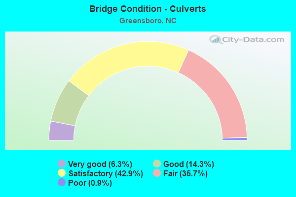
- Bridge Condition - Culverts
- 6.3%Very good
- 14.3%Good
- 42.9%Satisfactory
- 35.7%Fair
- 0.9%Poor
Find on map >> Show street view
Structure Number: 810831, Location: 0.95 MI. S. JCT. SR2147 (Lat: 36.075569, Lng: -79.915622), Route carried "under" structure: State highway 1008, Year Built: 2007, Structure Length: 0. m, Average Daily Traffic: 6,250 (year 2019), Truck Traffic: 6%, Features Intersected: I73,I840N
Minimum Vertical Clearance: 8.40m (27.56ft), Kilometerpoint: 0.000, Lanes on structure: 4, Lanes under structure: 2, Material/Design: Steel continuous, Design/Construction: Stringer/Multi-beam, Length of Maximum Span: 43.5m (142.7ft)
Find on map >> Show street view
Structure Number: 810831, Location: 0.95 MI. S. JCT. SR2147 (Lat: 36.075569, Lng: -79.915622), Route carried "under" structure: State highway 1008, Year Built: 2007, Structure Length: 0. m, Average Daily Traffic: 6,250 (year 2019), Truck Traffic: 6%, Features Intersected: I73,I840N
Minimum Vertical Clearance: 8.00m (26.25ft), Kilometerpoint: 0.000, Lanes on structure: 4, Lanes under structure: 2, Material/Design: Steel continuous, Design/Construction: Stringer/Multi-beam, Length of Maximum Span: 43.5m (142.7ft)
Find on map >> Show street view
Structure Number: 810832, Location: 0.95 MI. N. JCT. SR1008 (Lat: 36.089433, Lng: -79.915072), Route carried "under" structure: State highway 2147, Year Built: 2007, Structure Length: 0. m, Average Daily Traffic: 17,000 (year 2013), Truck Traffic: 6%, Features Intersected: I73, I840 SBL
Minimum Vertical Clearance: 6.55m (21.49ft), Kilometerpoint: 0.000, Lanes on structure: 3, Lanes under structure: 10, Material/Design: Steel, Design/Construction: Stringer/Multi-beam, Length of Maximum Span: 92.9m (304.8ft)
Find on map >> Show street view
Structure Number: 810833, Location: 1.6 MI. N. JCT. I40 (Lat: 36.089417, Lng: -79.914753), Route carried "under" structure: State highway 2147, Year Built: 2007, Structure Length: 0. m, Average Daily Traffic: 19,500 (year 2019), Truck Traffic: 6%, Features Intersected: I73, I840 NBL
Minimum Vertical Clearance: 5.51m (18.08ft), Kilometerpoint: 0.000, Lanes on structure: 3, Lanes under structure: 8, Material/Design: Steel, Design/Construction: Stringer/Multi-beam, Length of Maximum Span: 92.9m (304.8ft)
Find on map >> Show street view
Structure Number: 810838, Location: 0.6 MI. N. JCT. SR1424 (Lat: 36.048714, Lng: -79.919589), Route carried "under" structure: State highway 1541, Year Built: 2000, Structure Length: 0. m, Average Daily Traffic: 23,000 (year 2019), Truck Traffic: 12%, Features Intersected: SR1546
Minimum Vertical Clearance: 5.42m (17.78ft), Kilometerpoint: 0.000, Lanes on structure: 4, Lanes under structure: 4, Material/Design: Steel continuous, Design/Construction: Stringer/Multi-beam, Length of Maximum Span: 31.3m (102.7ft)
Find on map >> Show street view
Structure Number: 810838, Location: 0.6 MI. N. JCT. SR1424 (Lat: 36.048714, Lng: -79.919589), Route carried "under" structure: State highway 1541, Year Built: 2000, Structure Length: 0. m, Average Daily Traffic: 23,000 (year 2019), Truck Traffic: 12%, Features Intersected: SR1546
Minimum Vertical Clearance: 5.53m (18.14ft), Kilometerpoint: 0.000, Lanes on structure: 4, Lanes under structure: 4, Material/Design: Steel continuous, Design/Construction: Stringer/Multi-beam, Length of Maximum Span: 31.3m (102.7ft)
Find on map >> Show street view
Structure Number: 810842, Location: 0.8 MI. S. JCT. SR2137 (Lat: 36.101425, Lng: -79.914406), Route carried "under" structure: State highway 2181, Year Built: 2007, Structure Length: 0. m, Average Daily Traffic: 3,400 (year 2017), Truck Traffic: 7%, Features Intersected: I73,I840S
Minimum Vertical Clearance: 5.66m (18.57ft), Kilometerpoint: 0.000, Lanes on structure: 3, Lanes under structure: 2, Material/Design: Steel, Design/Construction: Stringer/Multi-beam, Length of Maximum Span: 43.8m (143.7ft)
Find on map >> Show street view
Structure Number: 810843, Location: 0.8 MI. S. JCT. SR2137 (Lat: 36.101456, Lng: -79.914086), Route carried "under" structure: State highway 2181, Year Built: 2007, Structure Length: 0. m, Average Daily Traffic: 3,400 (year 2017), Truck Traffic: 7%, Features Intersected: I73,I840N
Minimum Vertical Clearance: 5.48m (17.98ft), Kilometerpoint: 0.000, Lanes on structure: 2, Lanes under structure: 2, Material/Design: Steel, Design/Construction: Stringer/Multi-beam, Length of Maximum Span: 43.8m (143.7ft)
Find on map >> Show street view
Structure Number: 810844, Location: 0.25 MI. E. JCT. SR2175 (Lat: 36.112453, Lng: -79.909989), Route carried "under" structure: Interstate 73, Year Built: 2006, Structure Length: 0. m, Average Daily Traffic: 22,250 (year 2018), Truck Traffic: 16%, Features Intersected: SR2137
Minimum Vertical Clearance: 5.94m (19.49ft), Kilometerpoint: 0.000, Lanes on structure: 3, Lanes under structure: 2, Material/Design: Steel continuous, Design/Construction: Stringer/Multi-beam, Length of Maximum Span: 37.7m (123.7ft)
Find on map >> Show street view
Structure Number: 810844, Location: 0.25 MI. E. JCT. SR2175 (Lat: 36.112453, Lng: -79.909989), Route carried "under" structure: Interstate 840, Year Built: 2006, Structure Length: 0. m, Average Daily Traffic: 22,250 (year 2018), Truck Traffic: 16%, Features Intersected: SR2137
Minimum Vertical Clearance: 6.83m (22.41ft), Kilometerpoint: 0.000, Lanes on structure: 3, Lanes under structure: 3, Material/Design: Steel continuous, Design/Construction: Stringer/Multi-beam, Length of Maximum Span: 37.7m (123.7ft)
Find on map >> Show street view
Structure Number: 810844, Location: 0.25 MI. E. JCT. SR2175 (Lat: 36.112453, Lng: -79.909989), Route carried "under" structure: Interstate 840, Year Built: 2006, Structure Length: 0. m, Average Daily Traffic: 22,250 (year 2018), Truck Traffic: 16%, Features Intersected: SR2137
Minimum Vertical Clearance: 7.88m (25.85ft), Kilometerpoint: 0.000, Lanes on structure: 3, Lanes under structure: 4, Material/Design: Steel continuous, Design/Construction: Stringer/Multi-beam, Length of Maximum Span: 37.7m (123.7ft)
Find on map >> Show street view
Structure Number: 810844, Location: 0.25 MI. E. JCT. SR2175 (Lat: 36.112453, Lng: -79.909989), Route carried "under" structure: Interstate 73, Year Built: 2006, Structure Length: 0. m, Average Daily Traffic: 22,250 (year 2018), Truck Traffic: 16%, Features Intersected: SR2137
Minimum Vertical Clearance: 8.12m (26.64ft), Kilometerpoint: 0.000, Lanes on structure: 3, Lanes under structure: 2, Material/Design: Steel continuous, Design/Construction: Stringer/Multi-beam, Length of Maximum Span: 37.7m (123.7ft)
Find on map >> Show street view
Structure Number: 810845, Location: 0.25 MI. E. JCT. SR2137 (Lat: 36.117125, Lng: -79.908056), Route carried "under" structure: Ramp Interstate 73, Year Built: 2006, Structure Length: 0. m, Average Daily Traffic: 7,750 (year 2018), Truck Traffic: 16%, Features Intersected: SR2085 WBL
Minimum Vertical Clearance: 6.14m (20.14ft), Kilometerpoint: 0.000, Lanes on structure: 3, Lanes under structure: 1, Material/Design: Steel continuous, Design/Construction: Stringer/Multi-beam, Length of Maximum Span: 33.8m (110.9ft)
Find on map >> Show street view
Structure Number: 810845, Location: 0.25 MI. E. JCT. SR2137 (Lat: 36.117125, Lng: -79.908056), Route carried "under" structure: Interstate 840, Year Built: 2006, Structure Length: 0. m, Average Daily Traffic: 18,000 (year 2018), Truck Traffic: 16%, Features Intersected: SR2085 WBL
Minimum Vertical Clearance: 5.43m (17.81ft), Kilometerpoint: 0.000, Lanes on structure: 3, Lanes under structure: 3, Material/Design: Steel continuous, Design/Construction: Stringer/Multi-beam, Length of Maximum Span: 33.8m (110.9ft)
Find on map >> Show street view
Structure Number: 810845, Location: 0.25 MI. E. JCT. SR2137 (Lat: 36.117125, Lng: -79.908056), Route carried "under" structure: Interstate 840, Year Built: 2006, Structure Length: 0. m, Average Daily Traffic: 18,000 (year 2018), Truck Traffic: 16%, Features Intersected: SR2085 WBL
Minimum Vertical Clearance: 6.01m (19.72ft), Kilometerpoint: 0.000, Lanes on structure: 3, Lanes under structure: 3, Material/Design: Steel continuous, Design/Construction: Stringer/Multi-beam, Length of Maximum Span: 33.8m (110.9ft)
Find on map >> Show street view
Structure Number: 810846, Location: 0.25 MI. E. JCT. SR2137 (Lat: 36.116944, Lng: -79.908131), Route carried "under" structure: Interstate 840, Year Built: 2006, Structure Length: 0. m, Average Daily Traffic: 16,500 (year 2018), Truck Traffic: 16%, Features Intersected: SR2085 EBL
Minimum Vertical Clearance: 6.30m (20.67ft), Kilometerpoint: 0.000, Lanes on structure: 3, Lanes under structure: 3, Material/Design: Steel continuous, Design/Construction: Stringer/Multi-beam, Length of Maximum Span: 33.2m (108.9ft)
Find on map >> Show street view
Structure Number: 810846, Location: 0.25 MI. E. JCT. SR2137 (Lat: 36.116944, Lng: -79.908131), Route carried "under" structure: Interstate 73, Year Built: 2006, Structure Length: 0. m, Average Daily Traffic: 16,500 (year 2018), Truck Traffic: 16%, Features Intersected: SR2085 EBL
Minimum Vertical Clearance: 6.60m (21.65ft), Kilometerpoint: 0.000, Lanes on structure: 3, Lanes under structure: 1, Material/Design: Steel continuous, Design/Construction: Stringer/Multi-beam, Length of Maximum Span: 33.2m (108.9ft)
Find on map >> Show street view
Structure Number: 810846, Location: 0.25 MI. E. JCT. SR2137 (Lat: 36.116944, Lng: -79.908131), Route carried "under" structure: Interstate 840, Year Built: 2006, Structure Length: 0. m, Average Daily Traffic: 16,500 (year 2018), Truck Traffic: 16%, Features Intersected: SR2085 EBL
Minimum Vertical Clearance: 5.81m (19.06ft), Kilometerpoint: 0.000, Lanes on structure: 3, Lanes under structure: 3, Material/Design: Steel continuous, Design/Construction: Stringer/Multi-beam, Length of Maximum Span: 33.2m (108.9ft)
Find on map >> Show street view
Structure Number: 810847, Location: 0.55 MI. N. JCT. SR2137 (Lat: 36.116219, Lng: -79.905750), Route carried "under" structure: State highway 2085, Year Built: 2007, Structure Length: 0. m, Average Daily Traffic: 25,500 (year 2017), Truck Traffic: 12%, Features Intersected: I73,I840N.RAMP
Minimum Vertical Clearance: 5.68m (18.64ft), Kilometerpoint: 0.000, Lanes on structure: 2, Lanes under structure: 2, Material/Design: Steel continuous, Design/Construction: Stringer/Multi-beam, Length of Maximum Span: 32.6m (107.0ft)
Find on map >> Show street view
Structure Number: 810847, Location: 0.55 MI. N. JCT. SR2137 (Lat: 36.116219, Lng: -79.905750), Route carried "under" structure: State highway 2085, Year Built: 2007, Structure Length: 0. m, Average Daily Traffic: 27,500 (year 2018), Truck Traffic: 12%, Features Intersected: I73,I840N.RAMP
Minimum Vertical Clearance: 6.75m (22.15ft), Kilometerpoint: 0.000, Lanes on structure: 2, Lanes under structure: 2, Material/Design: Steel continuous, Design/Construction: Stringer/Multi-beam, Length of Maximum Span: 32.6m (107.0ft)
Find on map >> Show street view
Structure Number: 810848, Location: 1.3 MI. S. JCT. SR2137 (Lat: 36.118819, Lng: -79.906828), Route carried "under" structure: Ramp Interstate 73, Year Built: 2007, Structure Length: 0. m, Average Daily Traffic: 300 (year 2018), Truck Traffic: 14%, Features Intersected: I73,I840N.RAMP
Minimum Vertical Clearance: 5.99m (19.65ft), Kilometerpoint: 0.000, Lanes on structure: 2, Lanes under structure: 1, Material/Design: Steel continuous, Design/Construction: Stringer/Multi-beam, Length of Maximum Span: 29.2m (95.8ft)
Find on map >> Show street view
Structure Number: 810848, Location: 1.3 MI. S. JCT. SR2137 (Lat: 36.118819, Lng: -79.906828), Route carried "under" structure: Interstate 73, Year Built: 2007, Structure Length: 0. m, Average Daily Traffic: 1,000 (year 2018), Truck Traffic: 14%, Features Intersected: I73,I840N.RAMP
Minimum Vertical Clearance: 8.05m (26.41ft), Kilometerpoint: 0.000, Lanes on structure: 2, Lanes under structure: 3, Material/Design: Steel continuous, Design/Construction: Stringer/Multi-beam, Length of Maximum Span: 29.2m (95.8ft)
Find on map >> Show street view
Structure Number: 810848, Location: 1.3 MI. S. JCT. SR2137 (Lat: 36.118819, Lng: -79.906828), Route carried "under" structure: Interstate 73, Year Built: 2007, Structure Length: 0. m, Average Daily Traffic: 1,000 (year 2018), Truck Traffic: 14%, Features Intersected: I73,I840N.RAMP
Minimum Vertical Clearance: 6.98m (22.90ft), Kilometerpoint: 0.000, Lanes on structure: 2, Lanes under structure: 3, Material/Design: Steel continuous, Design/Construction: Stringer/Multi-beam, Length of Maximum Span: 29.2m (95.8ft)
Find on map >> Show street view
Structure Number: 810848, Location: 1.3 MI. S. JCT. SR2137 (Lat: 36.118819, Lng: -79.906828), Route carried "under" structure: Ramp Interstate 73, Year Built: 2007, Structure Length: 0. m, Average Daily Traffic: 300 (year 2018), Truck Traffic: 14%, Features Intersected: I73,I840N.RAMP
Minimum Vertical Clearance: 8.38m (27.49ft), Kilometerpoint: 0.000, Lanes on structure: 2, Lanes under structure: 1, Material/Design: Steel continuous, Design/Construction: Stringer/Multi-beam, Length of Maximum Span: 29.2m (95.8ft)
Find on map >> Show street view
Structure Number: 810849, Location: 0.9 MI. W. JCT. SR2136 (Lat: 36.114681, Lng: -79.908425), Route carried "under" structure: Ramp Interstate 7, Year Built: 2018, Structure Length: 0. m, Average Daily Traffic: 16,833 (year 2019), Truck Traffic: 16%, Features Intersected: I73,I840N.RAMP
Minimum Vertical Clearance: 5.86m (19.23ft), Kilometerpoint: 0.000, Lanes on structure: 1, Lanes under structure: 2, Material/Design: Steel, Design/Construction: Stringer/Multi-beam, Length of Maximum Span: 53.6m (175.9ft)
Find on map >> Show street view
Structure Number: 810849, Location: 0.9 MI. W. JCT. SR2136 (Lat: 36.114681, Lng: -79.908425), Route carried "under" structure: Interstate 73, Year Built: 2018, Structure Length: 0. m, Average Daily Traffic: 25,250 (year 2019), Truck Traffic: 16%, Features Intersected: I73,I840N.RAMP
Minimum Vertical Clearance: 6.34m (20.80ft), Kilometerpoint: 0.000, Lanes on structure: 1, Lanes under structure: 3, Material/Design: Steel, Design/Construction: Stringer/Multi-beam, Length of Maximum Span: 53.6m (175.9ft)
Find on map >> Show street view
Structure Number: 810849, Location: 0.9 MI. W. JCT. SR2136 (Lat: 36.114681, Lng: -79.908425), Route carried "under" structure: Interstate 73, Year Built: 2018, Structure Length: 0. m, Average Daily Traffic: 25,250 (year 2019), Truck Traffic: 16%, Features Intersected: I73,I840N.RAMP
Minimum Vertical Clearance: 5.94m (19.49ft), Kilometerpoint: 0.000, Lanes on structure: 1, Lanes under structure: 4, Material/Design: Steel, Design/Construction: Stringer/Multi-beam, Length of Maximum Span: 53.6m (175.9ft)
Find on map >> Show street view
Structure Number: 81085, Location: 0.6 MI. S. OF JCT. SR2136 (Lat: 36.116500, Lng: -79.905361), Route carried "under" structure: State highway 2085, Year Built: 2004, Structure Length: 0. m, Average Daily Traffic: 24,000 (year 2019), Truck Traffic: 12%, Features Intersected: I73,I840N.RAMP
Minimum Vertical Clearance: 5.89m (19.32ft), Kilometerpoint: 0.000, Lanes on structure: 1, Lanes under structure: 3, Material/Design: Steel, Design/Construction: Box Beam or Girders - Multiple, Length of Maximum Span: 48.1m (157.8ft)
Find on map >> Show street view
Structure Number: 81085, Location: 0.6 MI. S. OF JCT. SR2136 (Lat: 36.116500, Lng: -79.905361), Route carried "under" structure: State highway 2085, Year Built: 2004, Structure Length: 0. m, Average Daily Traffic: 24,000 (year 2019), Truck Traffic: 16%, Features Intersected: I73,I840N.RAMP
Minimum Vertical Clearance: 5.94m (19.49ft), Kilometerpoint: 0.000, Lanes on structure: 1, Lanes under structure: 1, Material/Design: Steel, Design/Construction: Box Beam or Girders - Multiple, Length of Maximum Span: 48.1m (157.8ft)
Find on map >> Show street view
Structure Number: 81085, Location: 0.6 MI. S. OF JCT. SR2136 (Lat: 36.116500, Lng: -79.905361), Route carried "under" structure: State highway 2085, Year Built: 2004, Structure Length: 0. m, Average Daily Traffic: 24,000 (year 2019), Truck Traffic: 12%, Features Intersected: I73,I840N.RAMP
Minimum Vertical Clearance: 5.53m (18.14ft), Kilometerpoint: 0.000, Lanes on structure: 1, Lanes under structure: 3, Material/Design: Steel, Design/Construction: Box Beam or Girders - Multiple, Length of Maximum Span: 48.1m (157.8ft)
Find on map >> Show street view
Structure Number: 810861, Location: 1.2 MI. E. JCT. SR4121 (Lat: 36.036231, Lng: -79.890242), Route carried "under" structure: State highway 1424, Year Built: 2008, Structure Length: 0. m, Average Daily Traffic: 12,000 (year 2017), Truck Traffic: 6%, Features Intersected: I73S,US421S
Minimum Vertical Clearance: 8.20m (26.90ft), Kilometerpoint: 0.000, Lanes on structure: 4, Lanes under structure: 5, Material/Design: Prestressed concrete continuous, Design/Construction: Stringer/Multi-beam, Length of Maximum Span: 36.8m (120.7ft)
Find on map >> Show street view
Structure Number: 810862, Location: 1.2 MI.W. JCT. SR4121 (Lat: 36.036108, Lng: -79.889836), Route carried "under" structure: State highway 1424, Year Built: 2008, Structure Length: 0. m, Average Daily Traffic: 12,000 (year 2018), Truck Traffic: 6%, Features Intersected: I73,US421N
Minimum Vertical Clearance: 6.32m (20.73ft), Kilometerpoint: 0.000, Lanes on structure: 4, Lanes under structure: 5, Material/Design: Prestressed concrete continuous, Design/Construction: Stringer/Multi-beam, Length of Maximum Span: 36.8m (120.7ft)
Find on map >> Show street view
Structure Number: 810863, Location: 0.9 MI. S. JCT. SR1541 (Lat: 36.045464, Lng: -79.902536), Route carried "under" structure: Interstate 73, Year Built: 2008, Structure Length: 0. m, Average Daily Traffic: 28,500 (year 2018), Truck Traffic: 16%, Features Intersected: SR4126
Minimum Vertical Clearance: 5.66m (18.57ft), Kilometerpoint: 31.029, Lanes on structure: 5, Lanes under structure: 4, Material/Design: Steel continuous, Design/Construction: Stringer/Multi-beam, Length of Maximum Span: 42.6m (139.8ft)
Find on map >> Show street view
Structure Number: 810863, Location: 0.9 MI. S. JCT. SR1541 (Lat: 36.045464, Lng: -79.902536), Route carried "under" structure: Interstate 73, Year Built: 2008, Structure Length: 0. m, Average Daily Traffic: 28,500 (year 2018), Truck Traffic: 16%, Features Intersected: SR4126
Minimum Vertical Clearance: 6.62m (21.72ft), Kilometerpoint: 31.029, Lanes on structure: 5, Lanes under structure: 4, Material/Design: Steel continuous, Design/Construction: Stringer/Multi-beam, Length of Maximum Span: 42.6m (139.8ft)
Find on map >> Show street view
Structure Number: 810864, Location: 0.9 MI. W. JCT. SR4126 (Lat: 36.050303, Lng: -79.915744), Route carried "under" structure: State highway 1541, Year Built: 2008, Structure Length: 0. m, Average Daily Traffic: 16,500 (year 2018), Truck Traffic: 12%, Features Intersected: I73S,I40E,US421S
Minimum Vertical Clearance: 6.62m (21.72ft), Kilometerpoint: 0.000, Lanes on structure: 5, Lanes under structure: 4, Material/Design: Steel continuous, Design/Construction: Stringer/Multi-beam, Length of Maximum Span: 33.2m (108.9ft)
Find on map >> Show street view
Structure Number: 810864, Location: 0.9 MI. W. JCT. SR4126 (Lat: 36.050303, Lng: -79.915744), Route carried "under" structure: State highway 1541, Year Built: 2008, Structure Length: 0. m, Average Daily Traffic: 16,500 (year 2018), Truck Traffic: 12%, Features Intersected: I73S,I40E,US421S
Minimum Vertical Clearance: 6.68m (21.92ft), Kilometerpoint: 0.000, Lanes on structure: 5, Lanes under structure: 4, Material/Design: Steel continuous, Design/Construction: Stringer/Multi-beam, Length of Maximum Span: 33.2m (108.9ft)
Find on map >> Show street view
Structure Number: 810865, Location: 0.9 MI. W. JCT. SR4126 (Lat: 36.050425, Lng: -79.915447), Route carried "under" structure: State highway 1541, Year Built: 2008, Structure Length: 0. m, Average Daily Traffic: 21,000 (year 2017), Truck Traffic: 12%, Features Intersected: I73, US421 NBL
Minimum Vertical Clearance: 5.33m (17.49ft), Kilometerpoint: 0.000, Lanes on structure: 5, Lanes under structure: 4, Material/Design: Steel continuous, Design/Construction: Stringer/Multi-beam, Length of Maximum Span: 33.2m (108.9ft)
Find on map >> Show street view
Structure Number: 810865, Location: 0.9 MI. W. JCT. SR4126 (Lat: 36.050425, Lng: -79.915447), Route carried "under" structure: State highway 1541, Year Built: 2008, Structure Length: 0. m, Average Daily Traffic: 21,000 (year 2017), Truck Traffic: 12%, Features Intersected: I73, US421 NBL
Minimum Vertical Clearance: 5.31m (17.42ft), Kilometerpoint: 0.000, Lanes on structure: 5, Lanes under structure: 4, Material/Design: Steel continuous, Design/Construction: Stringer/Multi-beam, Length of Maximum Span: 33.2m (108.9ft)
Find on map >> Show street view
Structure Number: 810866, Location: 0.3 MI. E. JCT. SR1541 (Lat: 36.054019, Lng: -79.917997), Route carried "under" structure: State highway 1546, Year Built: 2008, Structure Length: 0. m, Average Daily Traffic: 23,000 (year 2017), Truck Traffic: 6%, Features Intersected: I73, US421 SBL
Minimum Vertical Clearance: 7.31m (23.98ft), Kilometerpoint: 0.000, Lanes on structure: 5, Lanes under structure: 5, Material/Design: Prestressed concrete continuous, Design/Construction: Stringer/Multi-beam, Length of Maximum Span: 25.9m (85.0ft)
Find on map >> Show street view
Structure Number: 810867, Location: 0.3 MI. W. JCT. SR1541 (Lat: 36.054150, Lng: -79.917703), Route carried "under" structure: State highway 1546, Year Built: 2008, Structure Length: 0. m, Average Daily Traffic: 23,000 (year 2018), Truck Traffic: 6%, Features Intersected: I73, US421 NBL
Minimum Vertical Clearance: 6.19m (20.31ft), Kilometerpoint: 0.000, Lanes on structure: 5, Lanes under structure: 5, Material/Design: Prestressed concrete continuous, Design/Construction: Stringer/Multi-beam, Length of Maximum Span: 25.9m (85.0ft)
Find on map >> Show street view
Structure Number: 810868, Location: 0.7 MI. W. JCT. I85 BUS (Lat: 36.015314, Lng: -79.852978), Route carried "under" structure: Interstate 73, Year Built: 2008, Structure Length: 0. m, Average Daily Traffic: 29,500 (year 2018), Truck Traffic: 16%, Features Intersected: SR1383
Minimum Vertical Clearance: 5.48m (17.98ft), Kilometerpoint: 0.000, Lanes on structure: 6, Lanes under structure: 4, Material/Design: Steel continuous, Design/Construction: Stringer/Multi-beam, Length of Maximum Span: 61.2m (200.8ft)
Find on map >> Show street view
Structure Number: 810868, Location: 0.7 MI. W. JCT. I85 BUS (Lat: 36.015314, Lng: -79.852978), Route carried "under" structure: Interstate 73, Year Built: 2008, Structure Length: 0. m, Average Daily Traffic: 29,500 (year 2018), Truck Traffic: 26%, Features Intersected: SR1383
Minimum Vertical Clearance: 6.01m (19.72ft), Kilometerpoint: 0.000, Lanes on structure: 6, Lanes under structure: 5, Material/Design: Steel continuous, Design/Construction: Stringer/Multi-beam, Length of Maximum Span: 61.2m (200.8ft)
Find on map >> Show street view
Structure Number: 810869, Location: 0.6 MI. E. JCT. SR4121 (Lat: 36.020719, Lng: -79.865681), Route carried "under" structure: State highway 1129, Year Built: 2008, Structure Length: 0. m, Average Daily Traffic: 12,000 (year 2016), Truck Traffic: 6%, Features Intersected: I73 & US421 SBL
Minimum Vertical Clearance: 5.71m (18.73ft), Kilometerpoint: 0.000, Lanes on structure: 4, Lanes under structure: 5, Material/Design: Steel, Design/Construction: Stringer/Multi-beam, Length of Maximum Span: 40.2m (131.9ft)
Find on map >> Show street view
Structure Number: 81087, Location: 0.6 MI. S. JCT. SR4121 (Lat: 36.020961, Lng: -79.865692), Route carried "under" structure: State highway 1129, Year Built: 2008, Structure Length: 0. m, Average Daily Traffic: 12,000 (year 2013), Truck Traffic: 6%, Features Intersected: I73,US421N
Minimum Vertical Clearance: 5.28m (17.32ft), Kilometerpoint: 0.000, Lanes on structure: 4, Lanes under structure: 5, Material/Design: Steel, Design/Construction: Stringer/Multi-beam, Length of Maximum Span: 40.2m (131.9ft)
Find on map >> Show street view
Structure Number: 810871, Location: 0.3 MI. E. JCT. SR4121 (Lat: 36.020094, Lng: -79.873944), Route carried "under" structure: State highway 4205, Year Built: 2008, Structure Length: 0. m, Average Daily Traffic: 100 (year 2020), Truck Traffic: 7%, Features Intersected: I73 & US421 SBL
Minimum Vertical Clearance: 6.32m (20.73ft), Kilometerpoint: 0.000, Lanes on structure: 4, Lanes under structure: 2, Material/Design: Steel, Design/Construction: Stringer/Multi-beam, Length of Maximum Span: 38.7m (127.0ft)
Find on map >> Show street view
Structure Number: 810872, Location: 0.3 MI. E. JCT. SR4121 (Lat: 36.020347, Lng: -79.873786), Route carried "under" structure: State highway 4205, Year Built: 2008, Structure Length: 0. m, Average Daily Traffic: 100 (year 2008), Truck Traffic: 7%, Features Intersected: I73, US421 NBL
Minimum Vertical Clearance: 4.62m (15.16ft), Kilometerpoint: 0.000, Lanes on structure: 4, Lanes under structure: 2, Material/Design: Steel, Design/Construction: Stringer/Multi-beam, Length of Maximum Span: 38.7m (127.0ft)
Find on map >> Show street view
Structure Number: 810873, Location: 0.8 MI. S. JCT. SR1129 (Lat: 36.022694, Lng: -79.878275), Route carried "under" structure: Interstate 73, Year Built: 2008, Structure Length: 0. m, Average Daily Traffic: 29,500 (year 2018), Truck Traffic: 16%, Features Intersected: SR4121
Minimum Vertical Clearance: 7.06m (23.16ft), Kilometerpoint: 0.000, Lanes on structure: 2, Lanes under structure: 4, Material/Design: Steel continuous, Design/Construction: Stringer/Multi-beam, Length of Maximum Span: 42.6m (139.8ft)
Find on map >> Show street view
Structure Number: 810873, Location: 0.8 MI. S. JCT. SR1129 (Lat: 36.022694, Lng: -79.878275), Route carried "under" structure: Interstate 73, Year Built: 2008, Structure Length: 0. m, Average Daily Traffic: 29,500 (year 2018), Truck Traffic: 16%, Features Intersected: SR4121
Minimum Vertical Clearance: 5.99m (19.65ft), Kilometerpoint: 0.000, Lanes on structure: 2, Lanes under structure: 4, Material/Design: Steel continuous, Design/Construction: Stringer/Multi-beam, Length of Maximum Span: 42.6m (139.8ft)
Find on map >> Show street view
Structure Number: 810875, Location: 0.1 MI. N. JCT. I85 BUS (Lat: 36.003239, Lng: -79.847575), Route carried "under" structure: Bypass Interstate 85, Year Built: 2008, Structure Length: 0. m, Average Daily Traffic: 28,500 (year 2017), Truck Traffic: 16%, Features Intersected: I73, US421 SBL
Minimum Vertical Clearance: 13.46m (44.16ft), Kilometerpoint: 36.728, Lanes on structure: 3, Lanes under structure: 3, Material/Design: Steel continuous, Design/Construction: Stringer/Multi-beam, Length of Maximum Span: 74.6m (244.8ft)
Find on map >> Show street view
Structure Number: 810875, Location: 0.1 MI. N. JCT. I85 BUS (Lat: 36.003239, Lng: -79.847575), Route carried "under" structure: Bypass Interstate 85, Year Built: 2008, Structure Length: 0. m, Average Daily Traffic: 28,500 (year 2017), Truck Traffic: 16%, Features Intersected: I73, US421 SBL
Minimum Vertical Clearance: 12.87m (42.22ft), Kilometerpoint: 36.728, Lanes on structure: 3, Lanes under structure: 3, Material/Design: Steel continuous, Design/Construction: Stringer/Multi-beam, Length of Maximum Span: 74.6m (244.8ft)
Find on map >> Show street view
Structure Number: 810875, Location: 0.1 MI. N. JCT. I85 BUS (Lat: 36.003239, Lng: -79.847575), Route carried "under" structure: Ramp Interstate 85, Year Built: 2008, Structure Length: 0. m, Average Daily Traffic: 28,500 (year 2017), Truck Traffic: 16%, Features Intersected: I73, US421 SBL
Minimum Vertical Clearance: 6.50m (21.33ft), Kilometerpoint: 0.000, Lanes on structure: 3, Lanes under structure: 3, Material/Design: Steel continuous, Design/Construction: Stringer/Multi-beam, Length of Maximum Span: 74.6m (244.8ft)
Find on map >> Show street view
Structure Number: 810876, Location: 0.2 MI. N. JCT. I85 BUS (Lat: 36.003867, Lng: -79.846058), Route carried "under" structure: Bypass Interstate 85, Year Built: 2008, Structure Length: 0. m, Average Daily Traffic: 27,750 (year 2018), Truck Traffic: 16%, Features Intersected: I-85RAMP
Minimum Vertical Clearance: 5.66m (18.57ft), Kilometerpoint: 36.759, Lanes on structure: 3, Lanes under structure: 3, Material/Design: Steel continuous, Design/Construction: Stringer/Multi-beam, Length of Maximum Span: 43.8m (143.7ft)
Find on map >> Show street view
Structure Number: 810876, Location: 0.2 MI. N. JCT. I85 BUS (Lat: 36.003867, Lng: -79.846058), Route carried "under" structure: Ramp Interstate 73, Year Built: 2008, Structure Length: 0. m, Average Daily Traffic: 27,750 (year 2018), Truck Traffic: 16%, Features Intersected: I-85RAMP
Minimum Vertical Clearance: 10.18m (33.40ft), Kilometerpoint: 0.000, Lanes on structure: 3, Lanes under structure: 2, Material/Design: Steel continuous, Design/Construction: Stringer/Multi-beam, Length of Maximum Span: 43.8m (143.7ft)
Find on map >> Show street view
Structure Number: 810876, Location: 0.2 MI. N. JCT. I85 BUS (Lat: 36.003867, Lng: -79.846058), Route carried "under" structure: Bypass Interstate 85, Year Built: 2008, Structure Length: 0. m, Average Daily Traffic: 27,750 (year 2018), Truck Traffic: 16%, Features Intersected: I-85RAMP
Minimum Vertical Clearance: 7.23m (23.72ft), Kilometerpoint: 36.759, Lanes on structure: 3, Lanes under structure: 3, Material/Design: Steel continuous, Design/Construction: Stringer/Multi-beam, Length of Maximum Span: 43.8m (143.7ft)
Find on map >> Show street view
Structure Number: 810876, Location: 0.2 MI. N. JCT. I85 BUS (Lat: 36.003867, Lng: -79.846058), Route carried "under" structure: Ramp Interstate 85, Year Built: 2008, Structure Length: 0. m, Average Daily Traffic: 27,750 (year 2018), Truck Traffic: 16%, Features Intersected: I-85RAMP
Minimum Vertical Clearance: 7.51m (24.64ft), Kilometerpoint: 0.000, Lanes on structure: 3, Lanes under structure: 3, Material/Design: Steel continuous, Design/Construction: Stringer/Multi-beam, Length of Maximum Span: 43.8m (143.7ft)
Find on map >> Show street view
Structure Number: 810877, Location: 0.8 MI. E. JCT. SR1398 (Lat: 36.005300, Lng: -79.851206), Route carried "under" structure: Business Interstate 85, Year Built: 2008, Structure Length: 0. m, Average Daily Traffic: 19,500 (year 2018), Truck Traffic: 16%, Features Intersected: I73S,US421S
Minimum Vertical Clearance: 6.07m (19.91ft), Kilometerpoint: 0.000, Lanes on structure: 4, Lanes under structure: 4, Material/Design: Steel continuous, Design/Construction: Stringer/Multi-beam, Length of Maximum Span: 35.9m (117.8ft)
Find on map >> Show street view
Structure Number: 810877, Location: 0.8 MI. E. JCT. SR1398 (Lat: 36.005300, Lng: -79.851206), Route carried "under" structure: Business Interstate 85, Year Built: 2008, Structure Length: 0. m, Average Daily Traffic: 19,666 (year 2018), Truck Traffic: 16%, Features Intersected: I73S,US421S
Minimum Vertical Clearance: 6.14m (20.14ft), Kilometerpoint: 0.000, Lanes on structure: 4, Lanes under structure: 3, Material/Design: Steel continuous, Design/Construction: Stringer/Multi-beam, Length of Maximum Span: 35.9m (117.8ft)
Find on map >> Show street view
Structure Number: 810877, Location: 0.8 MI. E. JCT. SR1398 (Lat: 36.005300, Lng: -79.851206), Route carried "under" structure: Ramp Interstate 85, Year Built: 2008, Structure Length: 0. m, Average Daily Traffic: 19,666 (year 2018), Truck Traffic: 16%, Features Intersected: I73S,US421S
Minimum Vertical Clearance: 7.08m (23.23ft), Kilometerpoint: 0.000, Lanes on structure: 4, Lanes under structure: 2, Material/Design: Steel continuous, Design/Construction: Stringer/Multi-beam, Length of Maximum Span: 35.9m (117.8ft)
Find on map >> Show street view
Structure Number: 810878, Location: 0.8 MI. N. JCT. SR1398 (Lat: 36.005722, Lng: -79.850375), Route carried "under" structure: Business Interstate 85, Year Built: 2008, Structure Length: 0. m, Average Daily Traffic: 23,000 (year 2018), Truck Traffic: 16%, Features Intersected: I73N,US421N
Minimum Vertical Clearance: 6.55m (21.49ft), Kilometerpoint: 0.000, Lanes on structure: 3, Lanes under structure: 3, Material/Design: Steel continuous, Design/Construction: Stringer/Multi-beam, Length of Maximum Span: 35.3m (115.8ft)
Find on map >> Show street view
Structure Number: 810878, Location: 0.8 MI. N. JCT. SR1398 (Lat: 36.005722, Lng: -79.850375), Route carried "under" structure: Ramp US 85, Year Built: 2008, Structure Length: 0. m, Average Daily Traffic: 8,000 (year 2018), Truck Traffic: 16%, Features Intersected: I73N,US421N
Minimum Vertical Clearance: 7.13m (23.39ft), Kilometerpoint: 0.000, Lanes on structure: 3, Lanes under structure: 2, Material/Design: Steel continuous, Design/Construction: Stringer/Multi-beam, Length of Maximum Span: 35.3m (115.8ft)
Find on map >> Show street view
Structure Number: 810878, Location: 0.8 MI. N. JCT. SR1398 (Lat: 36.005722, Lng: -79.850375), Route carried "under" structure: Business Interstate 85, Year Built: 2008, Structure Length: 0. m, Average Daily Traffic: 23,000 (year 2018), Truck Traffic: 16%, Features Intersected: I73N,US421N
Minimum Vertical Clearance: 5.63m (18.47ft), Kilometerpoint: 0.000, Lanes on structure: 3, Lanes under structure: 4, Material/Design: Steel continuous, Design/Construction: Stringer/Multi-beam, Length of Maximum Span: 35.3m (115.8ft)
Find on map >> Show street view
Structure Number: 810879, Location: 0.2 MI. N. JCT. I85 (Lat: 36.006947, Lng: -79.847911), Route carried "under" structure: Ramp Interstate 85, Year Built: 2008, Structure Length: 0. m, Average Daily Traffic: 20,000 (year 2018), Truck Traffic: 12%, Features Intersected: I85 RAMP
Minimum Vertical Clearance: 6.24m (20.47ft), Kilometerpoint: 0.000, Lanes on structure: 2, Lanes under structure: 1, Material/Design: Steel continuous, Design/Construction: Stringer/Multi-beam, Length of Maximum Span: 33.8m (110.9ft)
Find on map >> Show street view
Structure Number: 810879, Location: 0.2 MI. N. JCT. I85 (Lat: 36.006947, Lng: -79.847911), Route carried "under" structure: Business Interstate 85, Year Built: 2008, Structure Length: 0. m, Average Daily Traffic: 30,000 (year 2018), Truck Traffic: 12%, Features Intersected: I85 RAMP
Minimum Vertical Clearance: 5.89m (19.32ft), Kilometerpoint: 0.000, Lanes on structure: 2, Lanes under structure: 3, Material/Design: Steel continuous, Design/Construction: Stringer/Multi-beam, Length of Maximum Span: 33.8m (110.9ft)
Find on map >> Show street view
Structure Number: 810879, Location: 0.2 MI. N. JCT. I85 (Lat: 36.006947, Lng: -79.847911), Route carried "under" structure: Business Interstate 85, Year Built: 2008, Structure Length: 0. m, Average Daily Traffic: 30,000 (year 2018), Truck Traffic: 12%, Features Intersected: I85 RAMP
Minimum Vertical Clearance: 5.28m (17.32ft), Kilometerpoint: 0.000, Lanes on structure: 2, Lanes under structure: 3, Material/Design: Steel continuous, Design/Construction: Stringer/Multi-beam, Length of Maximum Span: 33.8m (110.9ft)
Find on map >> Show street view
Structure Number: 81088, Location: 0.8 MI. W. JCT. SR3045 (Lat: 36.059011, Lng: -79.677353), Route carried "under" structure: Bypass Interstate 85, Year Built: 2001, Structure Length: 0. m, Average Daily Traffic: 22,500 (year 2017), Truck Traffic: 16%, Features Intersected: I40E,I85BUS.N
Minimum Vertical Clearance: 5.73m (18.80ft), Kilometerpoint: 40.234, Lanes on structure: 4, Lanes under structure: 3, Material/Design: Steel continuous, Design/Construction: Stringer/Multi-beam, Length of Maximum Span: 54.2m (177.8ft)
Find on map >> Show street view
Structure Number: 81088, Location: 0.8 MI. W. JCT. SR3045 (Lat: 36.059011, Lng: -79.677353), Route carried "under" structure: Bypass Interstate 85, Year Built: 2001, Structure Length: 0. m, Average Daily Traffic: 22,500 (year 2017), Truck Traffic: 16%, Features Intersected: I40E,I85BUS.N
Minimum Vertical Clearance: 6.88m (22.57ft), Kilometerpoint: 40.234, Lanes on structure: 4, Lanes under structure: 3, Material/Design: Steel continuous, Design/Construction: Stringer/Multi-beam, Length of Maximum Span: 54.2m (177.8ft)
Find on map >> Show street view
Structure Number: 810883, Location: 0.1 MI. W. JCT. SR2137 (Lat: 36.122917, Lng: -79.934139), Route carried "under" structure: Ramp State highway 2085, Year Built: 2009, Structure Length: 0. m, Average Daily Traffic: 3,333 (year 2015), Truck Traffic: 12%, Features Intersected: SR2085W.RAMP
Minimum Vertical Clearance: 5.74m (18.83ft), Kilometerpoint: 0.000, Lanes on structure: 2, Lanes under structure: 1, Material/Design: Steel continuous, Design/Construction: Stringer/Multi-beam, Length of Maximum Span: 67.6m (221.8ft)
Find on map >> Show street view
Structure Number: 810883, Location: 0.1 MI. W. JCT. SR2137 (Lat: 36.122917, Lng: -79.934139), Route carried "under" structure: Interstate 73, Year Built: 2009, Structure Length: 0. m, Average Daily Traffic: 5,000 (year 2015), Truck Traffic: 12%, Features Intersected: SR2085W.RAMP
Minimum Vertical Clearance: 6.14m (20.14ft), Kilometerpoint: 0.000, Lanes on structure: 2, Lanes under structure: 2, Material/Design: Steel continuous, Design/Construction: Stringer/Multi-beam, Length of Maximum Span: 67.6m (221.8ft)
Find on map >> Show street view
Structure Number: 810883, Location: 0.1 MI. W. JCT. SR2137 (Lat: 36.122917, Lng: -79.934139), Route carried "under" structure: Interstate 73, Year Built: 2009, Structure Length: 0. m, Average Daily Traffic: 5,000 (year 2015), Truck Traffic: 12%, Features Intersected: SR2085W.RAMP
Minimum Vertical Clearance: 6.90m (22.64ft), Kilometerpoint: 0.000, Lanes on structure: 2, Lanes under structure: 2, Material/Design: Steel continuous, Design/Construction: Stringer/Multi-beam, Length of Maximum Span: 67.6m (221.8ft)
Find on map >> Show street view
Structure Number: 810883, Location: 0.1 MI. W. JCT. SR2137 (Lat: 36.122917, Lng: -79.934139), Route carried "under" structure: Ramp State highway 2137, Year Built: 2009, Structure Length: 0. m, Average Daily Traffic: 5,000 (year 2015), Truck Traffic: 12%, Features Intersected: SR2085W.RAMP
Minimum Vertical Clearance: 5.13m (16.83ft), Kilometerpoint: 0.000, Lanes on structure: 2, Lanes under structure: 1, Material/Design: Steel continuous, Design/Construction: Stringer/Multi-beam, Length of Maximum Span: 67.6m (221.8ft)
Find on map >> Show street view
Structure Number: 810883, Location: 0.1 MI. W. JCT. SR2137 (Lat: 36.122917, Lng: -79.934139), Route carried "under" structure: Ramp State highway 2085, Year Built: 2009, Structure Length: 0. m, Average Daily Traffic: 3,333 (year 2015), Truck Traffic: 12%, Features Intersected: SR2085W.RAMP
Minimum Vertical Clearance: 8.45m (27.72ft), Kilometerpoint: 0.000, Lanes on structure: 2, Lanes under structure: 1, Material/Design: Steel continuous, Design/Construction: Stringer/Multi-beam, Length of Maximum Span: 67.6m (221.8ft)
Find on map >> Show street view
Structure Number: 810884, Location: 0.4 MI. E. JCT. SR2259 (Lat: 36.122264, Lng: -79.929106), Route carried "under" structure: State highway 2085, Year Built: 2009, Structure Length: 0. m, Average Daily Traffic: 5,000 (year 2015), Truck Traffic: 12%, Features Intersected: SR2137
Minimum Vertical Clearance: 5.69m (18.67ft), Kilometerpoint: 0.000, Lanes on structure: 5, Lanes under structure: 2, Material/Design: Steel continuous, Design/Construction: Stringer/Multi-beam, Length of Maximum Span: 74.6m (244.8ft)
Find on map >> Show street view
Structure Number: 810884, Location: 0.4 MI. E. JCT. SR2259 (Lat: 36.122264, Lng: -79.929106), Route carried "under" structure: State highway 2085, Year Built: 2009, Structure Length: 0. m, Average Daily Traffic: 5,000 (year 2015), Truck Traffic: 12%, Features Intersected: SR2137
Minimum Vertical Clearance: 6.45m (21.16ft), Kilometerpoint: 0.000, Lanes on structure: 5, Lanes under structure: 2, Material/Design: Steel continuous, Design/Construction: Stringer/Multi-beam, Length of Maximum Span: 74.6m (244.8ft)
Find on map >> Show street view
Structure Number: 810884, Location: 0.4 MI. E. JCT. SR2259 (Lat: 36.122264, Lng: -79.929106), Route carried "under" structure: Ramp State highway , Year Built: 2009, Structure Length: 0. m, Average Daily Traffic: 3,333 (year 2015), Truck Traffic: 16%, Features Intersected: SR2137, Facility Carried by Structure: SR2085N.RAMP
Minimum Vertical Clearance: 6.34m (20.80ft), Kilometerpoint: 0.000, Lanes on structure: 5, Lanes under structure: 3, Material/Design: Steel continuous, Design/Construction: Stringer/Multi-beam, Length of Maximum Span: 74.6m (244.8ft)
Find on map >> Show street view
Structure Number: 810884, Location: 0.4 MI. E. JCT. SR2259 (Lat: 36.122264, Lng: -79.929106), Route carried "under" structure: Ramp State highway 2084, Year Built: 2009, Structure Length: 0. m, Average Daily Traffic: 2,500 (year 2015), Truck Traffic: 16%, Features Intersected: SR2137, Facility Carried by Structure: SR2085S.COLL.
Minimum Vertical Clearance: 5.12m (16.80ft), Kilometerpoint: 0.000, Lanes on structure: 5, Lanes under structure: 1, Material/Design: Steel continuous, Design/Construction: Stringer/Multi-beam, Length of Maximum Span: 74.6m (244.8ft)
Find on map >> Show street view
Structure Number: 810888, Location: 0.1 MI. N. JCT. I40,85BUS (Lat: 36.058272, Lng: -79.685303), Route carried "under" structure: Interstate 785, Year Built: 2002, Structure Length: 0. m, Average Daily Traffic: 26,000 (year 2019), Truck Traffic: 16%, Features Intersected: I785,I840 SBL RAMP
Minimum Vertical Clearance: 6.78m (22.24ft), Kilometerpoint: 0.000, Lanes on structure: 2, Lanes under structure: 2, Material/Design: Steel continuous, Design/Construction: Stringer/Multi-beam, Length of Maximum Span: 47.2m (154.9ft)
Find on map >> Show street view
Structure Number: 810888, Location: 0.1 MI. N. JCT. I40,85BUS (Lat: 36.058272, Lng: -79.685303), Route carried "under" structure: Interstate 785, Year Built: 2002, Structure Length: 0. m, Average Daily Traffic: 26,000 (year 2019), Truck Traffic: 16%, Features Intersected: I785,I840 SBL RAMP
Minimum Vertical Clearance: 5.46m (17.91ft), Kilometerpoint: 0.000, Lanes on structure: 2, Lanes under structure: 4, Material/Design: Steel continuous, Design/Construction: Stringer/Multi-beam, Length of Maximum Span: 47.2m (154.9ft)
Find on map >> Show street view
Structure Number: 810889, Location: 0.15 MI.S.JCT.I85/40 (Lat: 36.058450, Lng: -79.683333), Route carried "under" structure: Ramp Interstate 40, Year Built: 2002, Structure Length: 0. m, Average Daily Traffic: 19,500 (year 2019), Truck Traffic: 16%, Features Intersected: I785,I840 SBL RAMP
Minimum Vertical Clearance: 6.98m (22.90ft), Kilometerpoint: 0.000, Lanes on structure: 2, Lanes under structure: 2, Material/Design: Steel, Design/Construction: Stringer/Multi-beam, Length of Maximum Span: 35.0m (114.8ft)
Find on map >> Show street view
Structure Number: 81089, Location: 0.75 MI. W. AIRPORT PKWY (Lat: 36.122508, Lng: -79.931261), Route carried "under" structure: Ramp Interstate 73, Year Built: 2009, Structure Length: 0. m, Average Daily Traffic: 3,333 (year 2018), Truck Traffic: 16%, Features Intersected: I-73RMP.
Minimum Vertical Clearance: 5.63m (18.47ft), Kilometerpoint: 0.000, Lanes on structure: 1, Lanes under structure: 1, Material/Design: Steel continuous, Design/Construction: Stringer/Multi-beam, Length of Maximum Span: 64.6m (211.9ft)
Find on map >> Show street view
Structure Number: 81089, Location: 0.75 MI. W. AIRPORT PKWY (Lat: 36.122508, Lng: -79.931261), Route carried "under" structure: Interstate 73, Year Built: 2009, Structure Length: 0. m, Average Daily Traffic: 5,000 (year 2018), Truck Traffic: 12%, Features Intersected: I-73RMP.
Minimum Vertical Clearance: 5.23m (17.16ft), Kilometerpoint: 0.000, Lanes on structure: 1, Lanes under structure: 2, Material/Design: Steel continuous, Design/Construction: Stringer/Multi-beam, Length of Maximum Span: 64.6m (211.9ft)
Find on map >> Show street view
Structure Number: 81089, Location: 0.75 MI. W. AIRPORT PKWY (Lat: 36.122508, Lng: -79.931261), Route carried "under" structure: Interstate 73, Year Built: 2009, Structure Length: 0. m, Average Daily Traffic: 5,000 (year 2018), Truck Traffic: 12%, Features Intersected: I-73RMP.
Minimum Vertical Clearance: 5.28m (17.32ft), Kilometerpoint: 0.000, Lanes on structure: 1, Lanes under structure: 2, Material/Design: Steel continuous, Design/Construction: Stringer/Multi-beam, Length of Maximum Span: 64.6m (211.9ft)
Find on map >> Show street view
Structure Number: 810891, Location: 0.2 MI W OF OLD OAK RIDGE (Lat: 36.120333, Lng: -79.930600), Route carried "under" structure: Ramp State highway , Year Built: 2009, Structure Length: 0. m, Average Daily Traffic: 3,333 (year 2018), Truck Traffic: 16%, Features Intersected: SR2085 RMP, Facility Carried by Structure: NCTEDJOHNSONPKWY R
Minimum Vertical Clearance: 6.06m (19.88ft), Kilometerpoint: 0.000, Lanes on structure: 2, Lanes under structure: 1, Material/Design: Steel, Design/Construction: Stringer/Multi-beam, Length of Maximum Span: 60.9m (199.8ft)
Find on map >> Show street view
Structure Number: 810891, Location: 0.2 MI W OF OLD OAK RIDGE (Lat: 36.120333, Lng: -79.930600), Route carried "under" structure: Ramp State highway , Year Built: 2009, Structure Length: 0. m, Average Daily Traffic: 3,333 (year 2018), Truck Traffic: 16%, Features Intersected: SR2085 RMP, Facility Carried by Structure: NCTEDJOHNSONPKWY R
Minimum Vertical Clearance: 5.36m (17.59ft), Kilometerpoint: 0.000, Lanes on structure: 2, Lanes under structure: 1, Material/Design: Steel, Design/Construction: Stringer/Multi-beam, Length of Maximum Span: 60.9m (199.8ft)
Find on map >> Show street view
Structure Number: 810902, Location: 1.3 MI. E. JCT. SR3029 (Lat: 36.053472, Lng: -79.685203), Route carried "under" structure: Bypass Interstate 85, Year Built: 2003, Structure Length: 0. m, Average Daily Traffic: 26,000 (year 2019), Truck Traffic: 16%, Features Intersected: SR3000
Minimum Vertical Clearance: 7.31m (23.98ft), Kilometerpoint: 39.868, Lanes on structure: 2, Lanes under structure: 3, Material/Design: Steel continuous, Design/Construction: Stringer/Multi-beam, Length of Maximum Span: 38.1m (125.0ft)
Find on map >> Show street view
Structure Number: 810902, Location: 1.3 MI. E. JCT. SR3029 (Lat: 36.053472, Lng: -79.685203), Route carried "under" structure: Ramp Interstate 85, Year Built: 2003, Structure Length: 0. m, Average Daily Traffic: 13,000 (year 2019), Truck Traffic: 16%, Features Intersected: SR3000
Minimum Vertical Clearance: 6.09m (19.98ft), Kilometerpoint: 0.000, Lanes on structure: 2, Lanes under structure: 3, Material/Design: Steel continuous, Design/Construction: Stringer/Multi-beam, Length of Maximum Span: 38.1m (125.0ft)
Find on map >> Show street view
Structure Number: 810902, Location: 1.3 MI. E. JCT. SR3029 (Lat: 36.053472, Lng: -79.685203), Route carried "under" structure: Interstate 785, Year Built: 2003, Structure Length: 0. m, Average Daily Traffic: 13,000 (year 2019), Truck Traffic: 16%, Features Intersected: SR3000
Minimum Vertical Clearance: 6.68m (21.92ft), Kilometerpoint: 0.000, Lanes on structure: 2, Lanes under structure: 2, Material/Design: Steel continuous, Design/Construction: Stringer/Multi-beam, Length of Maximum Span: 38.1m (125.0ft)
Find on map >> Show street view
Structure Number: 810902, Location: 1.3 MI. E. JCT. SR3029 (Lat: 36.053472, Lng: -79.685203), Route carried "under" structure: Bypass Interstate 85, Year Built: 2003, Structure Length: 0. m, Average Daily Traffic: 26,000 (year 2019), Truck Traffic: 16%, Features Intersected: SR3000
Minimum Vertical Clearance: 7.89m (25.89ft), Kilometerpoint: 39.868, Lanes on structure: 2, Lanes under structure: 3, Material/Design: Steel continuous, Design/Construction: Stringer/Multi-beam, Length of Maximum Span: 38.1m (125.0ft)
Find on map >> Show street view
Structure Number: 810903, Location: 0.1 MI. N. JCT. SR3000 (Lat: 36.054906, Lng: -79.684186), Route carried "under" structure: Bypass Interstate 85, Year Built: 2003, Structure Length: 0. m, Average Daily Traffic: 21,000 (year 2018), Truck Traffic: 16%, Features Intersected: I785N,I840N
Minimum Vertical Clearance: 5.79m (19.00ft), Kilometerpoint: 39.898, Lanes on structure: 2, Lanes under structure: 4, Material/Design: Steel continuous, Design/Construction: Stringer/Multi-beam, Length of Maximum Span: 49.0m (160.8ft)
Find on map >> Show street view
Structure Number: 810903, Location: 0.1 MI. N. JCT. SR3000 (Lat: 36.054906, Lng: -79.684186), Route carried "under" structure: Interstate 85, Year Built: 2003, Structure Length: 0. m, Average Daily Traffic: 21,000 (year 2018), Truck Traffic: 16%, Features Intersected: I785N,I840N
Minimum Vertical Clearance: 5.13m (16.83ft), Kilometerpoint: 39.898, Lanes on structure: 2, Lanes under structure: 3, Material/Design: Steel continuous, Design/Construction: Stringer/Multi-beam, Length of Maximum Span: 49.0m (160.8ft)
Find on map >> Show street view
Structure Number: 810987, Location: 0.2 MI. S. JCT. US70 (Lat: 36.086989, Lng: -79.696544), Route carried "under" structure: State highway 4762, Year Built: 2002, Structure Length: 0. m, Average Daily Traffic: 300 (year 2008), Truck Traffic: 7%, Features Intersected: I785 N, I840 E
Minimum Vertical Clearance: 8.05m (26.41ft), Kilometerpoint: 0.000, Lanes on structure: 1, Lanes under structure: 2, Material/Design: Prestressed concrete continuous, Design/Construction: Stringer/Multi-beam, Length of Maximum Span: 14.3m (46.9ft)
Find on map >> Show street view
Structure Number: 810989, Location: 0.5 MI. N. JCT. SR4762 (Lat: 36.089908, Lng: -79.697572), Route carried "under" structure: US 70, Year Built: 2002, Structure Length: 0. m, Average Daily Traffic: 15,000 (year 2017), Truck Traffic: 12%, Features Intersected: I785 NBL, I840 EBL
Minimum Vertical Clearance: 7.04m (23.10ft), Kilometerpoint: 0.000, Lanes on structure: 3, Lanes under structure: 2, Material/Design: Steel, Design/Construction: Stringer/Multi-beam, Length of Maximum Span: 29.5m (96.8ft)
Find on map >> Show street view
Structure Number: 810989, Location: 0.5 MI. N. JCT. SR4762 (Lat: 36.089908, Lng: -79.697572), Route carried "under" structure: US 70, Year Built: 2002, Structure Length: 0. m, Average Daily Traffic: 15,000 (year 2017), Truck Traffic: 12%, Features Intersected: I785 NBL, I840 EBL
Minimum Vertical Clearance: 6.94m (22.77ft), Kilometerpoint: 0.000, Lanes on structure: 3, Lanes under structure: 4, Material/Design: Steel, Design/Construction: Stringer/Multi-beam, Length of Maximum Span: 29.5m (96.8ft)
Find on map >> Show street view
Structure Number: 81099, Location: 0.2 MI. S. JCT. US70 (Lat: 36.086758, Lng: -79.697131), Route carried "under" structure: State highway 4762, Year Built: 2002, Structure Length: 0. m, Average Daily Traffic: 8 (year 2008), Truck Traffic: 7%, Features Intersected: I785, I840 S
Minimum Vertical Clearance: 6.95m (22.80ft), Kilometerpoint: 0.000, Lanes on structure: 2, Lanes under structure: 2, Material/Design: Prestressed concrete continuous, Design/Construction: Stringer/Multi-beam, Length of Maximum Span: 14.6m (47.9ft)
Find on map >> Show street view
Structure Number: 811047, Location: 1.0 MI. S. JCT. SR1546 (Lat: 36.060639, Lng: -79.902933), Route carried "under" structure: Interstate 40, Year Built: 2011, Structure Length: 0. m, Average Daily Traffic: 52,000 (year 2015), Truck Traffic: 16%, Features Intersected: SR4126 SBL
Minimum Vertical Clearance: 5.36m (17.59ft), Kilometerpoint: 64.709, Lanes on structure: 2, Lanes under structure: 3, Material/Design: Prestressed concrete continuous, Design/Construction: Stringer/Multi-beam, Length of Maximum Span: 35.6m (116.8ft)
Find on map >> Show street view
Structure Number: 811047, Location: 1.0 MI. S. JCT. SR1546 (Lat: 36.060639, Lng: -79.902933), Route carried "under" structure: Interstate 40, Year Built: 2011, Structure Length: 0. m, Average Daily Traffic: 52,000 (year 2015), Truck Traffic: 16%, Features Intersected: SR4126 SBL
Minimum Vertical Clearance: 5.51m (18.08ft), Kilometerpoint: 65.045, Lanes on structure: 2, Lanes under structure: 4, Material/Design: Prestressed concrete continuous, Design/Construction: Stringer/Multi-beam, Length of Maximum Span: 35.6m (116.8ft)
Find on map >> Show street view
Structure Number: 811047, Location: 1.0 MI. S. JCT. SR1546 (Lat: 36.060639, Lng: -79.902933), Route carried "under" structure: Interstate 40, Year Built: 2011, Structure Length: 0. m, Average Daily Traffic: 26,000 (year 2015), Truck Traffic: 16%, Features Intersected: SR4126 SBL
Minimum Vertical Clearance: 5.57m (18.27ft), Kilometerpoint: 64.709, Lanes on structure: 2, Lanes under structure: 2, Material/Design: Prestressed concrete continuous, Design/Construction: Stringer/Multi-beam, Length of Maximum Span: 35.6m (116.8ft)