Bridge Statistics for Greensboro, North Carolina (NC)
Condition, Traffic, Stress, Structural Evaluation, Project Costs
- National Bridge Inventory (NBI) Statistics
- 915Number of bridges
- 8,940ft / 2,725mTotal length
- 17,213,464Total average daily traffic
- 2,291,506Total average daily truck traffic
- National Bridge Inventory (NBI) Registered Bridges for Greensboro
- No street view available for this location
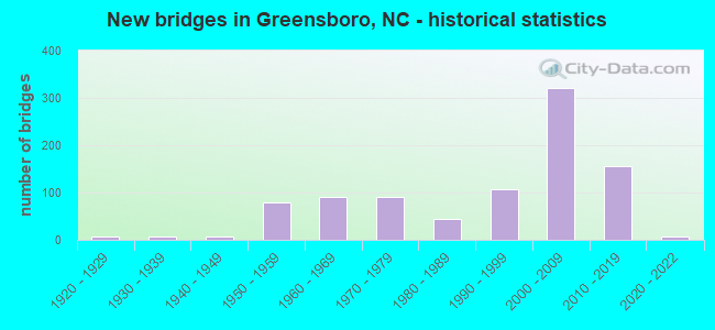
- New bridges - historical statistics
- 61920-1929
- 61930-1939
- 81940-1949
- 781950-1959
- 911960-1969
- 901970-1979
- 451980-1989
- 1081990-1999
- 3222000-2009
- 1552010-2019
- 62020-2022
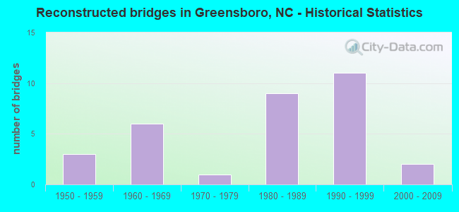
- Reconstructed bridges - Historical Statistics
- 31950-1959
- 61960-1969
- 11970-1979
- 91980-1989
- 111990-1999
- 22000-2009
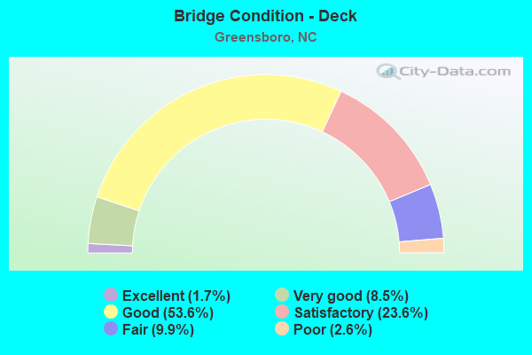
- Bridge Condition - Deck
- 1.7%Excellent
- 8.5%Very good
- 53.6%Good
- 23.6%Satisfactory
- 9.9%Fair
- 2.6%Poor
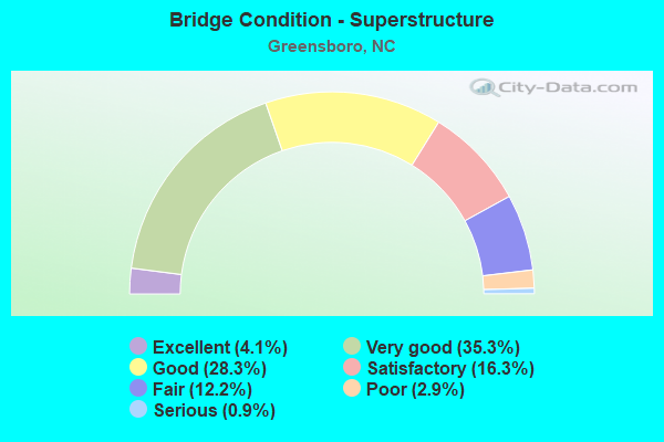
- Bridge Condition - Superstructure
- 4.1%Excellent
- 35.3%Very good
- 28.3%Good
- 16.3%Satisfactory
- 12.2%Fair
- 2.9%Poor
- 0.9%Serious
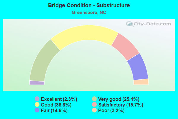
- Bridge Condition - Substructure
- 2.3%Excellent
- 25.4%Very good
- 38.8%Good
- 15.7%Satisfactory
- 14.6%Fair
- 3.2%Poor
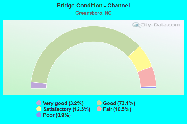
- Bridge Condition - Channel
- 3.2%Very good
- 73.1%Good
- 12.3%Satisfactory
- 10.5%Fair
- 0.9%Poor
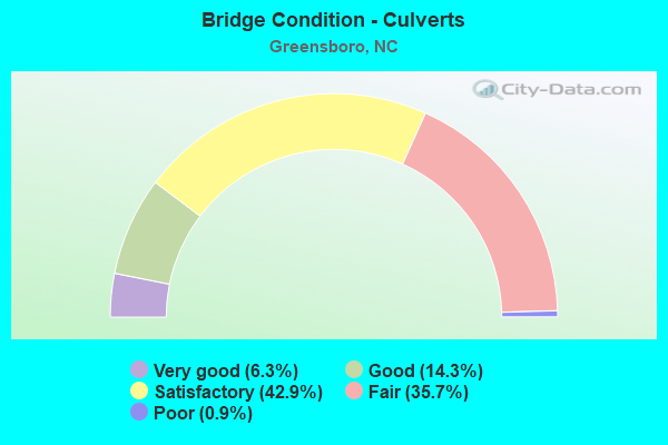
- Bridge Condition - Culverts
- 6.3%Very good
- 14.3%Good
- 42.9%Satisfactory
- 35.7%Fair
- 0.9%Poor
Find on map >> Show street view
Structure Number: 510376, Location: 0.47MI. S. JCT BRAGG BLVD (Lat: 35.111711, Lng: -78.969094), Route carried "under" structure: Ramp State highway 24, Year Built: 2019, Structure Length: 0. m, Average Daily Traffic: 2,500 (year 2018), Truck Traffic: 12%, Features Intersected: I-295N.RAMP
Minimum Vertical Clearance: 5.46m (17.91ft), Kilometerpoint: 0.000, Lanes on structure: 3, Lanes under structure: 2, Material/Design: Prestressed concrete, Design/Construction: Stringer/Multi-beam, Length of Maximum Span: 20.1m (65.9ft)
Find on map >> Show street view
Structure Number: 810001, Location: 1.1 MI. W. JCT. SR1008 (Lat: 36.065153, Lng: -79.848106), Route carried "under" structure: City street , Year Built: 1971, Structure Length: 0. m, Average Daily Traffic: 10,500 (year 2013), Truck Traffic: 6%, Features Intersected: SR2254 WBL, Facility Carried by Structure: HOLDEN ROAD,S
Minimum Vertical Clearance: 4.72m (15.49ft), Kilometerpoint: 0.000, Lanes on structure: 3, Lanes under structure: 2, Material/Design: Steel, Design/Construction: Stringer/Multi-beam, Length of Maximum Span: 17.3m (56.8ft)
Find on map >> Show street view
Structure Number: 810001, Location: 1.1 MI. W. JCT. SR1008 (Lat: 36.065153, Lng: -79.848106), Route carried "under" structure: City street , Year Built: 1971, Structure Length: 0. m, Average Daily Traffic: 10,500 (year 2013), Truck Traffic: 6%, Features Intersected: SR2254 WBL, Facility Carried by Structure: HOLDEN ROAD,N
Minimum Vertical Clearance: 4.96m (16.27ft), Kilometerpoint: 0.000, Lanes on structure: 3, Lanes under structure: 3, Material/Design: Steel, Design/Construction: Stringer/Multi-beam, Length of Maximum Span: 17.3m (56.8ft)
Find on map >> Show street view
Structure Number: 810015, Location: 0.6 MI. N. JCT. SR1118 (Lat: 36.018444, Lng: -79.826125), Route carried "under" structure: Business Interstate 85, Year Built: 1975, Structure Length: 0. m, Average Daily Traffic: 21,000 (year 2013), Truck Traffic: 12%, Features Intersected: US220
Minimum Vertical Clearance: 6.32m (20.73ft), Kilometerpoint: 10.576, Lanes on structure: 6, Lanes under structure: 4, Material/Design: Steel continuous, Design/Construction: Stringer/Multi-beam, Length of Maximum Span: 31.6m (103.7ft)
Find on map >> Show street view
Structure Number: 810015, Location: 0.6 MI. N. JCT. SR1118 (Lat: 36.018444, Lng: -79.826125), Route carried "under" structure: Business Interstate 85, Year Built: 1975, Structure Length: 0. m, Average Daily Traffic: 21,000 (year 2013), Truck Traffic: 12%, Features Intersected: US220
Minimum Vertical Clearance: 5.23m (17.16ft), Kilometerpoint: 10.576, Lanes on structure: 6, Lanes under structure: 4, Material/Design: Steel continuous, Design/Construction: Stringer/Multi-beam, Length of Maximum Span: 31.6m (103.7ft)
Find on map >> Show street view
Structure Number: 810017, Location: 0.45M E. JCT. SR2526 (Lat: 36.087519, Lng: -79.766400), Route carried "under" structure: US 29, Year Built: 1959, Structure Length: 0. m, Average Daily Traffic: 30,500 (year 2015), Truck Traffic: 12%, Features Intersected: US70E
Minimum Vertical Clearance: 4.92m (16.14ft), Kilometerpoint: 0.000, Lanes on structure: 3, Lanes under structure: 3, Material/Design: Prestressed concrete, Design/Construction: Stringer/Multi-beam, Length of Maximum Span: 14.9m (48.9ft)
Find on map >> Show street view
Structure Number: 810017, Location: 0.45M E. JCT. SR2526 (Lat: 36.087519, Lng: -79.766400), Route carried "under" structure: US 29, Year Built: 1959, Structure Length: 0. m, Average Daily Traffic: 30,500 (year 2015), Truck Traffic: 12%, Features Intersected: US70E
Minimum Vertical Clearance: 5.15m (16.90ft), Kilometerpoint: 0.000, Lanes on structure: 3, Lanes under structure: 3, Material/Design: Prestressed concrete, Design/Construction: Stringer/Multi-beam, Length of Maximum Span: 14.9m (48.9ft)
Find on map >> Show street view
Structure Number: 810018, Location: 0.45 MI. E. JCT. SR2526 (Lat: 36.087686, Lng: -79.766369), Route carried "under" structure: US 29, Year Built: 1959, Structure Length: 0. m, Average Daily Traffic: 29,000 (year 2015), Truck Traffic: 12%, Features Intersected: US70 WBL,US220 NBL
Minimum Vertical Clearance: 4.85m (15.91ft), Kilometerpoint: 0.000, Lanes on structure: 3, Lanes under structure: 3, Material/Design: Prestressed concrete, Design/Construction: Stringer/Multi-beam, Length of Maximum Span: 14.9m (48.9ft)
Find on map >> Show street view
Structure Number: 810018, Location: 0.45 MI. E. JCT. SR2526 (Lat: 36.087686, Lng: -79.766369), Route carried "under" structure: US 29, Year Built: 1959, Structure Length: 0. m, Average Daily Traffic: 29,000 (year 2015), Truck Traffic: 12%, Features Intersected: US70 WBL,US220 NBL
Minimum Vertical Clearance: 4.59m (15.06ft), Kilometerpoint: 0.000, Lanes on structure: 3, Lanes under structure: 3, Material/Design: Prestressed concrete, Design/Construction: Stringer/Multi-beam, Length of Maximum Span: 14.9m (48.9ft)
Find on map >> Show street view
Structure Number: 810021, Location: 1.0 MI. W. JCT. US70 (Lat: 36.073547, Lng: -79.766339), Route carried "under" structure: US 29, Year Built: 2006, Structure Length: 0. m, Average Daily Traffic: 36,500 (year 2019), Truck Traffic: 12%, Features Intersected: EAST MARKET STREET
Minimum Vertical Clearance: 5.30m (17.39ft), Kilometerpoint: 0.000, Lanes on structure: 4, Lanes under structure: 3, Material/Design: Steel, Design/Construction: Stringer/Multi-beam, Length of Maximum Span: 45.4m (149.0ft)
Find on map >> Show street view
Structure Number: 810021, Location: 1.0 MI. W. JCT. US70 (Lat: 36.073547, Lng: -79.766339), Route carried "under" structure: US 29, Year Built: 2006, Structure Length: 0. m, Average Daily Traffic: 36,500 (year 2019), Truck Traffic: 12%, Features Intersected: EAST MARKET STREET
Minimum Vertical Clearance: 5.35m (17.55ft), Kilometerpoint: 0.000, Lanes on structure: 4, Lanes under structure: 3, Material/Design: Steel, Design/Construction: Stringer/Multi-beam, Length of Maximum Span: 45.4m (149.0ft)
Find on map >> Show street view
Structure Number: 810022, Location: 0.55 MI. W. JCT. SR3300 (Lat: 36.033122, Lng: -79.800881), Route carried "under" structure: Interstate 40, Year Built: 1966, Structure Length: 0. m, Average Daily Traffic: 68,000 (year 2019), Truck Traffic: 16%, Features Intersected: SR1007
Minimum Vertical Clearance: 5.12m (16.80ft), Kilometerpoint: 66.934, Lanes on structure: 6, Lanes under structure: 4, Material/Design: Steel, Design/Construction: Stringer/Multi-beam, Length of Maximum Span: 22.2m (72.8ft)
Find on map >> Show street view
Structure Number: 810041, Location: 50 ft. N. JCT. SR1861 (Lat: 36.098956, Lng: -80.018128), Route carried "under" structure: Business Interstate 40, Year Built: 1990, Structure Length: 0. m, Average Daily Traffic: 53,500 (year 2015), Truck Traffic: 12%, Features Intersected: SR2007
Minimum Vertical Clearance: 5.21m (17.09ft), Kilometerpoint: 5.608, Lanes on structure: 2, Lanes under structure: 2, Material/Design: Prestressed concrete, Design/Construction: Stringer/Multi-beam, Length of Maximum Span: 20.4m (66.9ft)
Find on map >> Show street view
Structure Number: 810041, Location: 50 ft. N. JCT. SR1861 (Lat: 36.098956, Lng: -80.018128), Route carried "under" structure: Business Interstate 40, Year Built: 1990, Structure Length: 0. m, Average Daily Traffic: 53,500 (year 2015), Truck Traffic: 12%, Features Intersected: SR2007
Minimum Vertical Clearance: 5.45m (17.88ft), Kilometerpoint: 5.608, Lanes on structure: 2, Lanes under structure: 2, Material/Design: Prestressed concrete, Design/Construction: Stringer/Multi-beam, Length of Maximum Span: 20.4m (66.9ft)
Find on map >> Show street view
Structure Number: 810042, Location: 0.95 MI. N. JCT. I40 (Lat: 36.054950, Lng: -79.854256), Route carried "under" structure: State highway 4239, Year Built: 1998, Structure Length: 0. m, Average Daily Traffic: 16,500 (year 2019), Truck Traffic: 6%, Features Intersected: MERRIT DRIVE
Minimum Vertical Clearance: 5.13m (16.83ft), Kilometerpoint: 0.000, Lanes on structure: 5, Lanes under structure: 2, Material/Design: Steel, Design/Construction: Stringer/Multi-beam, Length of Maximum Span: 21.6m (70.9ft)
Find on map >> Show street view
Structure Number: 810057, Location: 1.8 MI. N. JCT. SR1421 (Lat: 36.064228, Lng: -79.799389), Route carried "under" structure: State highway 4240, Year Built: 1973, Structure Length: 0. m, Average Daily Traffic: 10,500 (year 2013), Truck Traffic: 12%, Features Intersected: FREEMAN MILL ROAD
Minimum Vertical Clearance: 5.94m (19.49ft), Kilometerpoint: 0.000, Lanes on structure: 4, Lanes under structure: 2, Material/Design: Steel, Design/Construction: Stringer/Multi-beam, Length of Maximum Span: 27.1m (88.9ft)
Find on map >> Show street view
Structure Number: 810057, Location: 1.8 MI. N. JCT. SR1421 (Lat: 36.064228, Lng: -79.799389), Route carried "under" structure: State highway 4240, Year Built: 1973, Structure Length: 0. m, Average Daily Traffic: 10,500 (year 2013), Truck Traffic: 12%, Features Intersected: FREEMAN MILL ROAD
Minimum Vertical Clearance: 5.69m (18.67ft), Kilometerpoint: 0.000, Lanes on structure: 4, Lanes under structure: 2, Material/Design: Steel, Design/Construction: Stringer/Multi-beam, Length of Maximum Span: 27.1m (88.9ft)
Find on map >> Show street view
Structure Number: 810074, Location: 0.9 MI. N. JCT. I40 (Lat: 36.092206, Lng: -79.953872), Route carried "under" structure: State highway 1008, Year Built: 2001, Structure Length: 0. m, Average Daily Traffic: 13,000 (year 2019), Truck Traffic: 6%, Features Intersected: SR1695
Minimum Vertical Clearance: 5.84m (19.16ft), Kilometerpoint: 0.000, Lanes on structure: 2, Lanes under structure: 5, Material/Design: Steel continuous, Design/Construction: Stringer/Multi-beam, Length of Maximum Span: 36.5m (119.8ft)
Find on map >> Show street view
Structure Number: 810076, Location: 0.2 M. S. JCT. SR1924 (Lat: 36.092056, Lng: -79.996292), Route carried "under" structure: Interstate 40, Year Built: 1996, Structure Length: 0. m, Average Daily Traffic: 53,500 (year 2015), Truck Traffic: 16%, Features Intersected: SR1850
Minimum Vertical Clearance: 5.82m (19.09ft), Kilometerpoint: 63.307, Lanes on structure: 4, Lanes under structure: 4, Material/Design: Steel continuous, Design/Construction: Stringer/Multi-beam, Length of Maximum Span: 32.3m (106.0ft)
Find on map >> Show street view
Structure Number: 810076, Location: 0.2 M. S. JCT. SR1924 (Lat: 36.092056, Lng: -79.996292), Route carried "under" structure: Interstate 40, Year Built: 1996, Structure Length: 0. m, Average Daily Traffic: 53,500 (year 2015), Truck Traffic: 16%, Features Intersected: SR1850
Minimum Vertical Clearance: 5.57m (18.27ft), Kilometerpoint: 63.307, Lanes on structure: 4, Lanes under structure: 4, Material/Design: Steel continuous, Design/Construction: Stringer/Multi-beam, Length of Maximum Span: 32.3m (106.0ft)
Find on map >> Show street view
Structure Number: 810116, Location: 0.1 MI. E. JCT. NC68 (Lat: 36.079781, Lng: -79.957458), Route carried "under" structure: State highway 1695, Year Built: 2003, Structure Length: 0. m, Average Daily Traffic: 5,200 (year 2015), Truck Traffic: 7%, Features Intersected: I40 & US421
Minimum Vertical Clearance: 4.82m (15.81ft), Kilometerpoint: 64.039, Lanes on structure: 10, Lanes under structure: 2, Material/Design: Steel, Design/Construction: Stringer/Multi-beam, Length of Maximum Span: 23.1m (75.8ft)
Find on map >> Show street view
Structure Number: 810131, Location: 0.3 MI. N. OF JCT. SR3163 (Lat: 36.087575, Lng: -79.740333), Route carried "under" structure: US 70, Year Built: 1963, Structure Length: 0. m, Average Daily Traffic: 11,250 (year 2019), Truck Traffic: 12%, Features Intersected: SR2770
Minimum Vertical Clearance: 5.30m (17.39ft), Kilometerpoint: 0.000, Lanes on structure: 2, Lanes under structure: 3, Material/Design: Steel, Design/Construction: Stringer/Multi-beam, Length of Maximum Span: 22.8m (74.8ft)
Find on map >> Show street view
Structure Number: 810131, Location: 0.3 MI. N. OF JCT. SR3163 (Lat: 36.087575, Lng: -79.740333), Route carried "under" structure: US 70, Year Built: 1963, Structure Length: 0. m, Average Daily Traffic: 11,250 (year 2019), Truck Traffic: 12%, Features Intersected: SR2770
Minimum Vertical Clearance: 4.35m (14.27ft), Kilometerpoint: 0.000, Lanes on structure: 2, Lanes under structure: 2, Material/Design: Steel, Design/Construction: Stringer/Multi-beam, Length of Maximum Span: 22.8m (74.8ft)
Find on map >> Show street view
Structure Number: 810136, Location: 1 MI. W. JCT. SR2085 (Lat: 36.074597, Lng: -79.831928), Route carried "under" structure: State highway 1008, Year Built: 1971, Structure Length: 0. m, Average Daily Traffic: 7,000 (year 2017), Truck Traffic: 6%, Features Intersected: SR2254
Minimum Vertical Clearance: 4.74m (15.55ft), Kilometerpoint: 0.000, Lanes on structure: 5, Lanes under structure: 3, Material/Design: Steel, Design/Construction: Stringer/Multi-beam, Length of Maximum Span: 14.3m (46.9ft)
Find on map >> Show street view
Structure Number: 810136, Location: 1 MI. W. JCT. SR2085 (Lat: 36.074597, Lng: -79.831928), Route carried "under" structure: State highway 1008, Year Built: 1971, Structure Length: 0. m, Average Daily Traffic: 7,000 (year 2017), Truck Traffic: 6%, Features Intersected: SR2254
Minimum Vertical Clearance: 5.25m (17.22ft), Kilometerpoint: 0.000, Lanes on structure: 5, Lanes under structure: 3, Material/Design: Steel, Design/Construction: Stringer/Multi-beam, Length of Maximum Span: 14.3m (46.9ft)
Find on map >> Show street view
Structure Number: 810142, Location: 1.4 MI.S.JCT.SR1129 (Lat: 35.984986, Lng: -79.884014), Route carried "under" structure: Ramp Interstate 85, Year Built: 1981, Structure Length: 0. m, Average Daily Traffic: 8,500 (year 2019), Truck Traffic: 16%, Features Intersected: I85N
Minimum Vertical Clearance: 5.89m (19.32ft), Kilometerpoint: 0.000, Lanes on structure: 3, Lanes under structure: 1, Material/Design: Steel, Design/Construction: Stringer/Multi-beam, Length of Maximum Span: 24.6m (80.7ft)
Find on map >> Show street view
Structure Number: 810142, Location: 1.4 MI.S.JCT.SR1129 (Lat: 35.984986, Lng: -79.884014), Route carried "under" structure: US 29, Year Built: 1981, Structure Length: 0. m, Average Daily Traffic: 17,000 (year 2019), Truck Traffic: 14%, Features Intersected: I85N
Minimum Vertical Clearance: 5.23m (17.16ft), Kilometerpoint: 0.000, Lanes on structure: 3, Lanes under structure: 2, Material/Design: Steel, Design/Construction: Stringer/Multi-beam, Length of Maximum Span: 24.6m (80.7ft)
Find on map >> Show street view
Structure Number: 810144, Location: 1.4 MI. S. JCT. SR1129 (Lat: 35.985036, Lng: -79.884631), Route carried "under" structure: US 29, Year Built: 1981, Structure Length: 0. m, Average Daily Traffic: 17,000 (year 2019), Truck Traffic: 12%, Features Intersected: I85S
Minimum Vertical Clearance: 5.10m (16.73ft), Kilometerpoint: 0.000, Lanes on structure: 3, Lanes under structure: 2, Material/Design: Steel, Design/Construction: Stringer/Multi-beam, Length of Maximum Span: 25.9m (85.0ft)
Find on map >> Show street view
Structure Number: 810144, Location: 1.4 MI. S. JCT. SR1129 (Lat: 35.985036, Lng: -79.884631), Route carried "under" structure: Ramp Interstate 85, Year Built: 1981, Structure Length: 0. m, Average Daily Traffic: 17,000 (year 2019), Truck Traffic: 16%, Features Intersected: I85S
Minimum Vertical Clearance: 5.23m (17.16ft), Kilometerpoint: 0.000, Lanes on structure: 3, Lanes under structure: 1, Material/Design: Steel, Design/Construction: Stringer/Multi-beam, Length of Maximum Span: 25.9m (85.0ft)
Find on map >> Show street view
Structure Number: 810148, Location: 2.2 M. N. JCT. SR3283 (Lat: 36.033950, Lng: -79.800858), Route carried "under" structure: Interstate 400, Year Built: 1967, Structure Length: 0. m, Average Daily Traffic: 70,000 (year 2017), Truck Traffic: 16%, Features Intersected: SR1007, Facility Carried by Structure: I40W,I85S
Minimum Vertical Clearance: 5.76m (18.90ft), Kilometerpoint: 66.934, Lanes on structure: 6, Lanes under structure: 4, Material/Design: Steel, Design/Construction: Stringer/Multi-beam, Length of Maximum Span: 22.2m (72.8ft)
Find on map >> Show street view
Structure Number: 810149, Location: 1.0 MI. EAST JCT. US220 (Lat: 36.073869, Lng: -79.814700), Route carried "under" structure: State highway 1665, Year Built: 1961, Structure Length: 0. m, Average Daily Traffic: 8,250 (year 2019), Truck Traffic: 6%, Features Intersected: SR3841
Minimum Vertical Clearance: 4.54m (14.90ft), Kilometerpoint: 0.000, Lanes on structure: 6, Lanes under structure: 2, Material/Design: Steel, Design/Construction: Stringer/Multi-beam, Length of Maximum Span: 23.7m (77.8ft)
Find on map >> Show street view
Structure Number: 810149, Location: 1.0 MI. EAST JCT. US220 (Lat: 36.073869, Lng: -79.814700), Route carried "under" structure: State highway 1665, Year Built: 1961, Structure Length: 0. m, Average Daily Traffic: 8,250 (year 2019), Truck Traffic: 6%, Features Intersected: SR3841
Minimum Vertical Clearance: 5.05m (16.57ft), Kilometerpoint: 0.000, Lanes on structure: 6, Lanes under structure: 3, Material/Design: Steel, Design/Construction: Stringer/Multi-beam, Length of Maximum Span: 23.7m (77.8ft)
Find on map >> Show street view
Structure Number: 810152, Location: 1.6 MI. N. JCT. I40 (Lat: 36.064675, Lng: -79.786858), Route carried "under" structure: State highway 4240, Year Built: 1953, Structure Length: 0. m, Average Daily Traffic: 21,000 (year 2015), Truck Traffic: 12%, Features Intersected: MARTIN LUTHER KING
Minimum Vertical Clearance: 4.62m (15.16ft), Kilometerpoint: 0.000, Lanes on structure: 2, Lanes under structure: 5, Material/Design: Steel, Design/Construction: Stringer/Multi-beam, Length of Maximum Span: 21.3m (69.9ft)
Find on map >> Show street view
Structure Number: 810153, Location: 0.9 MI. N. JCT. NC68 (Lat: 36.075050, Lng: -79.942372), Route carried "under" structure: Interstate 40, Year Built: 2003, Structure Length: 0. m, Average Daily Traffic: 58,000 (year 2015), Truck Traffic: 16%, Features Intersected: SR1556
Minimum Vertical Clearance: 5.63m (18.47ft), Kilometerpoint: 64.313, Lanes on structure: 4, Lanes under structure: 5, Material/Design: Steel, Design/Construction: Stringer/Multi-beam, Length of Maximum Span: 31.6m (103.7ft)
Find on map >> Show street view
Structure Number: 810153, Location: 0.9 MI. N. JCT. NC68 (Lat: 36.075050, Lng: -79.942372), Route carried "under" structure: Interstate 40, Year Built: 2003, Structure Length: 0. m, Average Daily Traffic: 58,000 (year 2015), Truck Traffic: 16%, Features Intersected: SR1556
Minimum Vertical Clearance: 5.57m (18.27ft), Kilometerpoint: 64.313, Lanes on structure: 4, Lanes under structure: 6, Material/Design: Steel, Design/Construction: Stringer/Multi-beam, Length of Maximum Span: 31.6m (103.7ft)
Find on map >> Show street view
Structure Number: 810168, Location: 2.1 MI. N. JCT. NC68 (Lat: 36.070350, Lng: -79.929403), Route carried "under" structure: Interstate 40, Year Built: 2003, Structure Length: 0. m, Average Daily Traffic: 70,500 (year 2018), Truck Traffic: 16%, Features Intersected: SR5002
Minimum Vertical Clearance: 5.79m (19.00ft), Kilometerpoint: 64.557, Lanes on structure: 2, Lanes under structure: 6, Material/Design: Steel continuous, Design/Construction: Stringer/Multi-beam, Length of Maximum Span: 42.0m (137.8ft)
Find on map >> Show street view
Structure Number: 810168, Location: 2.1 MI. N. JCT. NC68 (Lat: 36.070350, Lng: -79.929403), Route carried "under" structure: Interstate 40, Year Built: 2003, Structure Length: 0. m, Average Daily Traffic: 70,500 (year 2018), Truck Traffic: 16%, Features Intersected: SR5002
Minimum Vertical Clearance: 5.09m (16.70ft), Kilometerpoint: 64.557, Lanes on structure: 2, Lanes under structure: 7, Material/Design: Steel continuous, Design/Construction: Stringer/Multi-beam, Length of Maximum Span: 42.0m (137.8ft)
Find on map >> Show street view
Structure Number: 810179, Location: 0.1 MI.N.JCT.LEE ST. (Lat: 36.066664, Lng: -79.784150), Route carried "under" structure: City street , Year Built: 1967, Structure Length: 0. m, Average Daily Traffic: 5,500 (year 2017), Truck Traffic: 6%, Features Intersected: GORRELL STREET, Facility Carried by Structure: MURROW BLVD.N
Minimum Vertical Clearance: 4.59m (15.06ft), Kilometerpoint: 0.000, Lanes on structure: 2, Lanes under structure: 3, Material/Design: Steel, Design/Construction: Stringer/Multi-beam, Length of Maximum Span: 16.1m (52.8ft)
Find on map >> Show street view
Structure Number: 810179, Location: 0.1 MI.N.JCT.LEE ST. (Lat: 36.066664, Lng: -79.784150), Route carried "under" structure: City street , Year Built: 1967, Structure Length: 0. m, Average Daily Traffic: 5,500 (year 2015), Truck Traffic: 7%, Features Intersected: GORRELL STREET, Facility Carried by Structure: MURROW BLVD.S
Minimum Vertical Clearance: 4.72m (15.49ft), Kilometerpoint: 0.000, Lanes on structure: 2, Lanes under structure: 2, Material/Design: Steel, Design/Construction: Stringer/Multi-beam, Length of Maximum Span: 16.1m (52.8ft)
Find on map >> Show street view
Structure Number: 810197, Location: 0.5 MI. N. OF JCT. SR1125 (Lat: 36.011069, Lng: -79.839622), Route carried "under" structure: Business Interstate 85, Year Built: 1974, Structure Length: 0. m, Average Daily Traffic: 28,250 (year 2019), Truck Traffic: 12%, Features Intersected: SR1117
Minimum Vertical Clearance: 5.61m (18.41ft), Kilometerpoint: 10.302, Lanes on structure: 4, Lanes under structure: 4, Material/Design: Steel, Design/Construction: Stringer/Multi-beam, Length of Maximum Span: 38.4m (126.0ft)
Find on map >> Show street view
Structure Number: 810197, Location: 0.5 MI. N. OF JCT. SR1125 (Lat: 36.011069, Lng: -79.839622), Route carried "under" structure: Business Interstate 850, Year Built: 1974, Structure Length: 0. m, Average Daily Traffic: 28,250 (year 2019), Truck Traffic: 12%, Features Intersected: SR1117, Facility Carried by Structure: I85N
Minimum Vertical Clearance: 5.38m (17.65ft), Kilometerpoint: 10.302, Lanes on structure: 4, Lanes under structure: 4, Material/Design: Steel, Design/Construction: Stringer/Multi-beam, Length of Maximum Span: 38.4m (126.0ft)
Find on map >> Show street view
Structure Number: 810198, Location: 1.38 MI. S.OF JCT. SR1008 (Lat: 36.062436, Lng: -79.907731), Route carried "under" structure: Interstate 40, Year Built: 2000, Structure Length: 0. m, Average Daily Traffic: 50,000 (year 2019), Truck Traffic: 16%, Features Intersected: SR1546
Minimum Vertical Clearance: 5.38m (17.65ft), Kilometerpoint: 0.000, Lanes on structure: 4, Lanes under structure: 4, Material/Design: Steel continuous, Design/Construction: Stringer/Multi-beam, Length of Maximum Span: 34.1m (111.9ft)
Find on map >> Show street view
Structure Number: 810198, Location: 1.38 MI. S.OF JCT. SR1008 (Lat: 36.062436, Lng: -79.907731), Route carried "under" structure: Interstate 40, Year Built: 2000, Structure Length: 0. m, Average Daily Traffic: 50,000 (year 2019), Truck Traffic: 16%, Features Intersected: SR1546
Minimum Vertical Clearance: 5.45m (17.88ft), Kilometerpoint: 64.953, Lanes on structure: 4, Lanes under structure: 4, Material/Design: Steel continuous, Design/Construction: Stringer/Multi-beam, Length of Maximum Span: 34.1m (111.9ft)
Find on map >> Show street view
Structure Number: 810202, Location: 0.2 MI. N. OF JCT.US220 (Lat: 36.019817, Lng: -79.823217), Route carried "under" structure: State highway 1121, Year Built: 1975, Structure Length: 0. m, Average Daily Traffic: 5,500 (year 2019), Truck Traffic: 6%, Features Intersected: I85 BUS.
Minimum Vertical Clearance: 4.90m (16.08ft), Kilometerpoint: 0.000, Lanes on structure: 7, Lanes under structure: 2, Material/Design: Steel, Design/Construction: Stringer/Multi-beam, Length of Maximum Span: 32.6m (107.0ft)
Find on map >> Show street view
Structure Number: 810202, Location: 0.2 MI. N. OF JCT.US220 (Lat: 36.019817, Lng: -79.823217), Route carried "under" structure: State highway 1121, Year Built: 1975, Structure Length: 0. m, Average Daily Traffic: 5,500 (year 2019), Truck Traffic: 6%, Features Intersected: I85 BUS.
Minimum Vertical Clearance: 5.46m (17.91ft), Kilometerpoint: 0.000, Lanes on structure: 7, Lanes under structure: 3, Material/Design: Steel, Design/Construction: Stringer/Multi-beam, Length of Maximum Span: 32.6m (107.0ft)
Find on map >> Show street view
Structure Number: 810217, Location: 0.4 MI. W. OF.JCT SR2526 (Lat: 36.087706, Lng: -79.782547), Route carried "under" structure: City street , Year Built: 1968, Structure Length: 0. m, Average Daily Traffic: 6,000 (year 2019), Truck Traffic: 6%, Features Intersected: US220, Facility Carried by Structure: YANCEYVILLE ST.S.
Minimum Vertical Clearance: 5.30m (17.39ft), Kilometerpoint: 0.000, Lanes on structure: 6, Lanes under structure: 3, Material/Design: Steel, Design/Construction: Stringer/Multi-beam, Length of Maximum Span: 23.1m (75.8ft)
Find on map >> Show street view
Structure Number: 810217, Location: 0.4 MI. W. OF.JCT SR2526 (Lat: 36.087706, Lng: -79.782547), Route carried "under" structure: City street , Year Built: 1968, Structure Length: 0. m, Average Daily Traffic: 6,000 (year 2019), Truck Traffic: 6%, Features Intersected: US220, Facility Carried by Structure: YANCEYVILLESTREETN
Minimum Vertical Clearance: 4.82m (15.81ft), Kilometerpoint: 0.000, Lanes on structure: 6, Lanes under structure: 2, Material/Design: Steel, Design/Construction: Stringer/Multi-beam, Length of Maximum Span: 23.1m (75.8ft)
Find on map >> Show street view
Structure Number: 81022, Location: 1.5 MI. E. JCT. I73 (Lat: 36.056442, Lng: -79.891497), Route carried "under" structure: Interstate 40, Year Built: 1988, Structure Length: 0. m, Average Daily Traffic: 59,500 (year 2019), Truck Traffic: 16%, Features Intersected: SR1541
Minimum Vertical Clearance: 6.24m (20.47ft), Kilometerpoint: 65.258, Lanes on structure: 6, Lanes under structure: 4, Material/Design: Steel, Design/Construction: Stringer/Multi-beam, Length of Maximum Span: 34.7m (113.8ft)
Find on map >> Show street view
Structure Number: 81022, Location: 1.5 MI. E. JCT. I73 (Lat: 36.056442, Lng: -79.891497), Route carried "under" structure: Interstate 40, Year Built: 1988, Structure Length: 0. m, Average Daily Traffic: 59,500 (year 2019), Truck Traffic: 16%, Features Intersected: SR1541
Minimum Vertical Clearance: 5.54m (18.18ft), Kilometerpoint: 65.258, Lanes on structure: 6, Lanes under structure: 3, Material/Design: Steel, Design/Construction: Stringer/Multi-beam, Length of Maximum Span: 34.7m (113.8ft)
Find on map >> Show street view
Structure Number: 810221, Location: 0.55 MI.N.JCT.NC6(LEE ST) (Lat: 36.069903, Lng: -79.783681), Route carried "under" structure: City street , Year Built: 1967, Structure Length: 0. m, Average Daily Traffic: 6,500 (year 2017), Truck Traffic: 7%, Features Intersected: WASHINGTON STREET, Facility Carried by Structure: MURROW BLVD.S
Minimum Vertical Clearance: 4.57m (14.99ft), Kilometerpoint: 0.000, Lanes on structure: 2, Lanes under structure: 3, Material/Design: Steel, Design/Construction: Stringer/Multi-beam, Length of Maximum Span: 16.4m (53.8ft)
Find on map >> Show street view
Structure Number: 810221, Location: 0.55 MI.N.JCT.NC6(LEE ST) (Lat: 36.069903, Lng: -79.783681), Route carried "under" structure: City street , Year Built: 1967, Structure Length: 0. m, Average Daily Traffic: 6,500 (year 2017), Truck Traffic: 7%, Features Intersected: WASHINGTON STREET, Facility Carried by Structure: MURROW BLVD.N
Minimum Vertical Clearance: 4.62m (15.16ft), Kilometerpoint: 0.000, Lanes on structure: 2, Lanes under structure: 3, Material/Design: Steel, Design/Construction: Stringer/Multi-beam, Length of Maximum Span: 16.4m (53.8ft)
Find on map >> Show street view
Structure Number: 810225, Location: 0.3 MI. W. JCT. SR3303 (Lat: 36.021967, Lng: -79.818781), Route carried "under" structure: Business Interstate 85, Year Built: 1975, Structure Length: 0. m, Average Daily Traffic: 19,000 (year 2015), Truck Traffic: 12%, Features Intersected: SR1115
Minimum Vertical Clearance: 5.05m (16.57ft), Kilometerpoint: 10.729, Lanes on structure: 4, Lanes under structure: 4, Material/Design: Steel, Design/Construction: Stringer/Multi-beam, Length of Maximum Span: 27.4m (89.9ft)
Find on map >> Show street view
Structure Number: 810225, Location: 0.3 MI. W. JCT. SR3303 (Lat: 36.021967, Lng: -79.818781), Route carried "under" structure: Business Interstate 85, Year Built: 1975, Structure Length: 0. m, Average Daily Traffic: 19,000 (year 2015), Truck Traffic: 12%, Features Intersected: SR1115
Minimum Vertical Clearance: 5.30m (17.39ft), Kilometerpoint: 10.729, Lanes on structure: 4, Lanes under structure: 4, Material/Design: Steel, Design/Construction: Stringer/Multi-beam, Length of Maximum Span: 27.4m (89.9ft)
Find on map >> Show street view
Structure Number: 810253, Location: 0.2 MI.E.JCT.LINDSAY ST. (Lat: 36.078614, Lng: -79.783719), Route carried "under" structure: City street , Year Built: 1967, Structure Length: 0. m, Average Daily Traffic: 5,000 (year 2017), Truck Traffic: 6%, Features Intersected: SUMMITT AVE., Facility Carried by Structure: MURROW BLVD. W
Minimum Vertical Clearance: 4.92m (16.14ft), Kilometerpoint: 0.000, Lanes on structure: 6, Lanes under structure: 5, Material/Design: Steel, Design/Construction: Stringer/Multi-beam, Length of Maximum Span: 24.6m (80.7ft)
Find on map >> Show street view
Structure Number: 810253, Location: 0.2 MI.E.JCT.LINDSAY ST. (Lat: 36.078614, Lng: -79.783719), Route carried "under" structure: City street , Year Built: 1967, Structure Length: 0. m, Average Daily Traffic: 5,000 (year 2017), Truck Traffic: 7%, Features Intersected: SUMMITT AVE., Facility Carried by Structure: MURROW BLVD E
Minimum Vertical Clearance: 5.10m (16.73ft), Kilometerpoint: 0.000, Lanes on structure: 6, Lanes under structure: 5, Material/Design: Steel, Design/Construction: Stringer/Multi-beam, Length of Maximum Span: 24.6m (80.7ft)
Find on map >> Show street view
Structure Number: 810261, Location: 0.4 MI. W. JCT. SR1007 (Lat: 36.029194, Lng: -79.808408), Route carried "under" structure: Business Interstate 85, Year Built: 1975, Structure Length: 0. m, Average Daily Traffic: 2,000 (year 2015), Truck Traffic: 12%, Features Intersected: CREEK RIDGE ROAD
Minimum Vertical Clearance: 5.18m (16.99ft), Kilometerpoint: 10.972, Lanes on structure: 2, Lanes under structure: 3, Material/Design: Steel continuous, Design/Construction: Stringer/Multi-beam, Length of Maximum Span: 36.5m (119.8ft)
Find on map >> Show street view
Structure Number: 810261, Location: 0.4 MI. W. JCT. SR1007 (Lat: 36.029194, Lng: -79.808408), Route carried "under" structure: Business Interstate 85, Year Built: 1975, Structure Length: 0. m, Average Daily Traffic: 20,000 (year 2015), Truck Traffic: 12%, Features Intersected: CREEK RIDGE ROAD
Minimum Vertical Clearance: 5.15m (16.90ft), Kilometerpoint: 10.972, Lanes on structure: 2, Lanes under structure: 4, Material/Design: Steel continuous, Design/Construction: Stringer/Multi-beam, Length of Maximum Span: 36.5m (119.8ft)
Find on map >> Show street view
Structure Number: 810264, Location: 0.17 MI. W. JCT. SR3549 (Lat: 36.013336, Lng: -79.760494), Route carried "under" structure: State highway 3762, Year Built: 1970, Structure Length: 0. m, Average Daily Traffic: 6,500 (year 2018), Truck Traffic: 12%, Features Intersected: SR3314
Minimum Vertical Clearance: 5.18m (16.99ft), Kilometerpoint: 0.000, Lanes on structure: 2, Lanes under structure: 2, Material/Design: Steel, Design/Construction: Stringer/Multi-beam, Length of Maximum Span: 28.3m (92.8ft)
Find on map >> Show street view
Structure Number: 810264, Location: 0.17 MI. W. JCT. SR3549 (Lat: 36.013336, Lng: -79.760494), Route carried "under" structure: State highway 3762, Year Built: 1970, Structure Length: 0. m, Average Daily Traffic: 6,500 (year 2018), Truck Traffic: 12%, Features Intersected: SR3314
Minimum Vertical Clearance: 6.40m (21.00ft), Kilometerpoint: 0.000, Lanes on structure: 2, Lanes under structure: 2, Material/Design: Steel, Design/Construction: Stringer/Multi-beam, Length of Maximum Span: 28.3m (92.8ft)
Find on map >> Show street view
Structure Number: 810274, Location: 0.75 MI. N. JCT. SR2526 (Lat: 36.088056, Lng: -79.789047), Route carried "under" structure: City street , Year Built: 1968, Structure Length: 0. m, Average Daily Traffic: 6,000 (year 2013), Truck Traffic: 6%, Features Intersected: US220, Facility Carried by Structure: ELMSTREET,N
Minimum Vertical Clearance: 4.48m (14.70ft), Kilometerpoint: 0.000, Lanes on structure: 6, Lanes under structure: 2, Material/Design: Steel, Design/Construction: Stringer/Multi-beam, Length of Maximum Span: 20.1m (65.9ft)
Find on map >> Show street view
Structure Number: 810274, Location: 0.75 MI. N. JCT. SR2526 (Lat: 36.088056, Lng: -79.789047), Route carried "under" structure: City street , Year Built: 1968, Structure Length: 0. m, Average Daily Traffic: 6,000 (year 2013), Truck Traffic: 6%, Features Intersected: US220, Facility Carried by Structure: ELMSTREET,S
Minimum Vertical Clearance: 4.43m (14.53ft), Kilometerpoint: 0.000, Lanes on structure: 6, Lanes under structure: 1, Material/Design: Steel, Design/Construction: Stringer/Multi-beam, Length of Maximum Span: 20.1m (65.9ft)
Find on map >> Show street view
Structure Number: 810275, Location: 1.1 MI. S. JCT. US29 (Lat: 36.088117, Lng: -79.774731), Route carried "under" structure: US 220, Year Built: 1968, Structure Length: 0. m, Average Daily Traffic: 24,500 (year 2017), Truck Traffic: 12%, Features Intersected: SR2526
Minimum Vertical Clearance: 4.62m (15.16ft), Kilometerpoint: 0.000, Lanes on structure: 6, Lanes under structure: 3, Material/Design: Steel, Design/Construction: Stringer/Multi-beam, Length of Maximum Span: 17.3m (56.8ft)
Find on map >> Show street view
Structure Number: 810275, Location: 1.1 MI. S. JCT. US29 (Lat: 36.088117, Lng: -79.774731), Route carried "under" structure: US 220, Year Built: 1968, Structure Length: 0. m, Average Daily Traffic: 24,500 (year 2017), Truck Traffic: 12%, Features Intersected: SR2526
Minimum Vertical Clearance: 5.16m (16.93ft), Kilometerpoint: 0.000, Lanes on structure: 6, Lanes under structure: 3, Material/Design: Steel, Design/Construction: Stringer/Multi-beam, Length of Maximum Span: 17.3m (56.8ft)
Find on map >> Show street view
Structure Number: 810283, Location: 0.8 MI. N. JCT. US220 (Lat: 36.098344, Lng: -79.765244), Route carried "under" structure: US 29, Year Built: 1956, Structure Length: 0. m, Average Daily Traffic: 27,000 (year 2015), Truck Traffic: 12%, Features Intersected: SR2526N.RAMP
Minimum Vertical Clearance: 4.58m (15.03ft), Kilometerpoint: 6104.913, Lanes on structure: 2, Lanes under structure: 2, Material/Design: Steel, Design/Construction: Stringer/Multi-beam, Length of Maximum Span: 21.0m (68.9ft)
Find on map >> Show street view
Structure Number: 810283, Location: 0.8 MI. N. JCT. US220 (Lat: 36.098344, Lng: -79.765244), Route carried "under" structure: US 29, Year Built: 1956, Structure Length: 0. m, Average Daily Traffic: 27,000 (year 2015), Truck Traffic: 12%, Features Intersected: SR2526N.RAMP
Minimum Vertical Clearance: 4.53m (14.86ft), Kilometerpoint: 0.000, Lanes on structure: 2, Lanes under structure: 2, Material/Design: Steel, Design/Construction: Stringer/Multi-beam, Length of Maximum Span: 21.0m (68.9ft)
Find on map >> Show street view
Structure Number: 810284, Location: 1.2 MI. N. JCT. US70 (Lat: 36.102186, Lng: -79.763872), Route carried "under" structure: State highway 2526, Year Built: 1956, Structure Length: 0. m, Average Daily Traffic: 7,250 (year 2019), Truck Traffic: 6%, Features Intersected: US29S.RAMP
Minimum Vertical Clearance: 5.22m (17.13ft), Kilometerpoint: 0.000, Lanes on structure: 1, Lanes under structure: 2, Material/Design: Steel, Design/Construction: Stringer/Multi-beam, Length of Maximum Span: 22.5m (73.8ft)
Find on map >> Show street view
Structure Number: 810285, Location: 1.3 MI. S. JCT. NC6 (Lat: 36.045103, Lng: -79.774308), Route carried "under" structure: State highway 1401, Year Built: 1966, Structure Length: 0. m, Average Daily Traffic: 25,500 (year 2019), Truck Traffic: 6%, Features Intersected: US29 SBL
Minimum Vertical Clearance: 4.67m (15.32ft), Kilometerpoint: 0.000, Lanes on structure: 2, Lanes under structure: 2, Material/Design: Steel, Design/Construction: Stringer/Multi-beam, Length of Maximum Span: 24.9m (81.7ft)
Find on map >> Show street view
Structure Number: 810285, Location: 1.3 MI. S. JCT. NC6 (Lat: 36.045103, Lng: -79.774308), Route carried "under" structure: State highway 1401, Year Built: 1966, Structure Length: 0. m, Average Daily Traffic: 25,500 (year 2019), Truck Traffic: 6%, Features Intersected: US29 SBL
Minimum Vertical Clearance: 4.77m (15.65ft), Kilometerpoint: 0.000, Lanes on structure: 2, Lanes under structure: 2, Material/Design: Steel, Design/Construction: Stringer/Multi-beam, Length of Maximum Span: 24.9m (81.7ft)
Find on map >> Show street view
Structure Number: 810286, Location: 1.3 MI. E. JCT. SR1541 (Lat: 36.048561, Lng: -79.865233), Route carried "under" structure: State highway 4239, Year Built: 2003, Structure Length: 0. m, Average Daily Traffic: 14,000 (year 2017), Truck Traffic: 6%, Features Intersected: I40
Minimum Vertical Clearance: 5.38m (17.65ft), Kilometerpoint: 0.000, Lanes on structure: 6, Lanes under structure: 1, Material/Design: Steel, Design/Construction: Stringer/Multi-beam, Length of Maximum Span: 31.3m (102.7ft)
Find on map >> Show street view
Structure Number: 810291, Location: 0.2 MI. N. JCT. US421 (Lat: 36.046678, Lng: -79.768967), Route carried "under" structure: US 29, Year Built: 2016, Structure Length: 0. m, Average Daily Traffic: 32,000 (year 2017), Truck Traffic: 12%, Features Intersected: I40E,I85N;RAMP W
Minimum Vertical Clearance: 5.81m (19.06ft), Kilometerpoint: 0.000, Lanes on structure: 1, Lanes under structure: 2, Material/Design: Prestressed concrete, Design/Construction: Stringer/Multi-beam, Length of Maximum Span: 30.7m (100.7ft)
Find on map >> Show street view
Structure Number: 810292, Location: 1.8 MI. W. JCT. US29A (Lat: 36.087939, Lng: -79.808847), Route carried "under" structure: US 220, Year Built: 1968, Structure Length: 0. m, Average Daily Traffic: 15,500 (year 2017), Truck Traffic: 6%, Features Intersected: US220
Minimum Vertical Clearance: 5.00m (16.40ft), Kilometerpoint: 0.000, Lanes on structure: 6, Lanes under structure: 3, Material/Design: Steel, Design/Construction: Stringer/Multi-beam, Length of Maximum Span: 16.1m (52.8ft)
Find on map >> Show street view
Structure Number: 810292, Location: 1.8 MI. W. JCT. US29A (Lat: 36.087939, Lng: -79.808847), Route carried "under" structure: State highway 1452, Year Built: 1968, Structure Length: 0. m, Average Daily Traffic: 15,500 (year 2017), Truck Traffic: 6%, Features Intersected: US220
Minimum Vertical Clearance: 4.59m (15.06ft), Kilometerpoint: 0.000, Lanes on structure: 6, Lanes under structure: 3, Material/Design: Steel, Design/Construction: Stringer/Multi-beam, Length of Maximum Span: 16.1m (52.8ft)
Find on map >> Show street view
Structure Number: 810295, Location: 0.5 MI. N. JCT. NC6 (Lat: 36.048086, Lng: -79.856900), Route carried "under" structure: Interstate 40, Year Built: 2003, Structure Length: 0. m, Average Daily Traffic: 53,500 (year 2018), Truck Traffic: 16%, Features Intersected: MERRITT DR
Minimum Vertical Clearance: 5.73m (18.80ft), Kilometerpoint: 65.898, Lanes on structure: 2, Lanes under structure: 3, Material/Design: Steel continuous, Design/Construction: Stringer/Multi-beam, Length of Maximum Span: 52.4m (171.9ft)
Find on map >> Show street view
Structure Number: 810295, Location: 0.5 MI. N. JCT. NC6 (Lat: 36.048086, Lng: -79.856900), Route carried "under" structure: Interstate 40, Year Built: 2003, Structure Length: 0. m, Average Daily Traffic: 53,500 (year 2018), Truck Traffic: 16%, Features Intersected: MERRITT DR
Minimum Vertical Clearance: 6.52m (21.39ft), Kilometerpoint: 65.898, Lanes on structure: 2, Lanes under structure: 3, Material/Design: Steel continuous, Design/Construction: Stringer/Multi-beam, Length of Maximum Span: 52.4m (171.9ft)
Find on map >> Show street view
Structure Number: 810302, Location: 0.9 MI. E. JCT. SR3762 (Lat: 36.054594, Lng: -79.767972), Route carried "under" structure: US 29, Year Built: 1953, Structure Length: 0. m, Average Daily Traffic: 34,750 (year 2019), Truck Traffic: 12%, Features Intersected: TUSCALOOSA STREET
Minimum Vertical Clearance: 4.62m (15.16ft), Kilometerpoint: 0.000, Lanes on structure: 2, Lanes under structure: 2, Material/Design: Steel, Design/Construction: Stringer/Multi-beam, Length of Maximum Span: 14.0m (45.9ft)
Find on map >> Show street view
Structure Number: 810302, Location: 0.9 MI. E. JCT. SR3762 (Lat: 36.054594, Lng: -79.767972), Route carried "under" structure: US 29, Year Built: 1953, Structure Length: 0. m, Average Daily Traffic: 34,750 (year 2019), Truck Traffic: 12%, Features Intersected: TUSCALOOSA STREET
Minimum Vertical Clearance: 5.18m (16.99ft), Kilometerpoint: 0.000, Lanes on structure: 2, Lanes under structure: 2, Material/Design: Steel, Design/Construction: Stringer/Multi-beam, Length of Maximum Span: 14.0m (45.9ft)
Find on map >> Show street view
Structure Number: 810304, Location: 0.6 MI. E. JCT. NC6 (Lat: 36.046433, Lng: -79.849514), Route carried "under" structure: Interstate 40, Year Built: 2003, Structure Length: 0. m, Average Daily Traffic: 53,500 (year 2018), Truck Traffic: 16%, Features Intersected: HOLDEN ROAD
Minimum Vertical Clearance: 5.54m (18.18ft), Kilometerpoint: 66.020, Lanes on structure: 6, Lanes under structure: 3, Material/Design: Steel continuous, Design/Construction: Stringer/Multi-beam, Length of Maximum Span: 41.4m (135.8ft)
Find on map >> Show street view
Structure Number: 810304, Location: 0.6 MI. E. JCT. NC6 (Lat: 36.046433, Lng: -79.849514), Route carried "under" structure: Interstate 40, Year Built: 2003, Structure Length: 0. m, Average Daily Traffic: 53,500 (year 2018), Truck Traffic: 16%, Features Intersected: HOLDEN ROAD
Minimum Vertical Clearance: 5.05m (16.57ft), Kilometerpoint: 66.020, Lanes on structure: 6, Lanes under structure: 3, Material/Design: Steel continuous, Design/Construction: Stringer/Multi-beam, Length of Maximum Span: 41.4m (135.8ft)
Find on map >> Show street view
Structure Number: 810306, Location: 1.23 MI. N. JCT. I40 (Lat: 36.063494, Lng: -79.767261), Route carried "under" structure: State highway 4240, Year Built: 2004, Structure Length: 0. m, Average Daily Traffic: 17,000 (year 2019), Truck Traffic: 12%, Features Intersected: US29,US70,US220
Minimum Vertical Clearance: 5.30m (17.39ft), Kilometerpoint: 0.000, Lanes on structure: 6, Lanes under structure: 4, Material/Design: Steel continuous, Design/Construction: Stringer/Multi-beam, Length of Maximum Span: 26.8m (87.9ft)
Find on map >> Show street view
Structure Number: 810309, Location: 2.4 MI. N. JCT I85 (Lat: 36.035792, Lng: -79.791403), Route carried "under" structure: Business Interstate 40, Year Built: 1955, Structure Length: 0. m, Average Daily Traffic: 69,500 (year 2019), Truck Traffic: 16%, Features Intersected: S. ELM EUGENE ST.
Minimum Vertical Clearance: 5.69m (18.67ft), Kilometerpoint: 0.000, Lanes on structure: 6, Lanes under structure: 3, Material/Design: Steel, Design/Construction: Stringer/Multi-beam, Length of Maximum Span: 15.8m (51.8ft)
Find on map >> Show street view
Structure Number: 810309, Location: 2.4 MI. N. JCT I85 (Lat: 36.035792, Lng: -79.791403), Route carried "under" structure: Interstate 40, Year Built: 1955, Structure Length: 0. m, Average Daily Traffic: 69,500 (year 2019), Truck Traffic: 16%, Features Intersected: S. ELM EUGENE ST.
Minimum Vertical Clearance: 5.02m (16.47ft), Kilometerpoint: 0.000, Lanes on structure: 6, Lanes under structure: 3, Material/Design: Steel, Design/Construction: Stringer/Multi-beam, Length of Maximum Span: 15.8m (51.8ft)
Find on map >> Show street view
Structure Number: 810312, Location: 1.3 MI. W. OF JCT. US220 (Lat: 36.044106, Lng: -79.840903), Route carried "under" structure: State highway 4121, Year Built: 1976, Structure Length: 0. m, Average Daily Traffic: 14,500 (year 2017), Truck Traffic: 1%, Features Intersected: I40
Minimum Vertical Clearance: 4.87m (15.98ft), Kilometerpoint: 0.000, Lanes on structure: 6, Lanes under structure: 3, Material/Design: Steel, Design/Construction: Stringer/Multi-beam, Length of Maximum Span: 33.5m (109.9ft)
Find on map >> Show street view
Structure Number: 810312, Location: 1.3 MI. W. OF JCT. US220 (Lat: 36.044106, Lng: -79.840903), Route carried "under" structure: State highway 4121, Year Built: 1976, Structure Length: 0. m, Average Daily Traffic: 14,500 (year 2017), Truck Traffic: 12%, Features Intersected: I40
Minimum Vertical Clearance: 4.64m (15.22ft), Kilometerpoint: 0.000, Lanes on structure: 6, Lanes under structure: 4, Material/Design: Steel, Design/Construction: Stringer/Multi-beam, Length of Maximum Span: 33.5m (109.9ft)
Find on map >> Show street view
Structure Number: 810318, Location: 0.2 MI.W. JCT.SR4240 (Lat: 36.066350, Lng: -79.766467), Route carried "under" structure: US 29, Year Built: 2004, Structure Length: 0. m, Average Daily Traffic: 36,500 (year 2019), Truck Traffic: 12%, Features Intersected: MCCONNELL STREET
Minimum Vertical Clearance: 5.16m (16.93ft), Kilometerpoint: 0.000, Lanes on structure: 2, Lanes under structure: 3, Material/Design: Prestressed concrete continuous, Design/Construction: Stringer/Multi-beam, Length of Maximum Span: 23.7m (77.8ft)
Find on map >> Show street view
Structure Number: 810318, Location: 0.2 MI.W. JCT.SR4240 (Lat: 36.066350, Lng: -79.766467), Route carried "under" structure: US 29, Year Built: 2004, Structure Length: 0. m, Average Daily Traffic: 36,500 (year 2019), Truck Traffic: 12%, Features Intersected: MCCONNELL STREET
Minimum Vertical Clearance: 5.28m (17.32ft), Kilometerpoint: 0.000, Lanes on structure: 2, Lanes under structure: 3, Material/Design: Prestressed concrete continuous, Design/Construction: Stringer/Multi-beam, Length of Maximum Span: 23.7m (77.8ft)
Find on map >> Show street view
Structure Number: 810319, Location: 0.6 M. N. JCT. SR1323 (Lat: 36.040828, Lng: -79.832800), Route carried "under" structure: Interstate 40, Year Built: 1996, Structure Length: 0. m, Average Daily Traffic: 59,000 (year 2018), Truck Traffic: 16%, Features Intersected: VANSTORY STREET
Minimum Vertical Clearance: 5.51m (18.08ft), Kilometerpoint: 66.325, Lanes on structure: 5, Lanes under structure: 4, Material/Design: Steel continuous, Design/Construction: Stringer/Multi-beam, Length of Maximum Span: 40.5m (132.9ft)
Find on map >> Show street view
Structure Number: 810319, Location: 0.6 M. N. JCT. SR1323 (Lat: 36.040828, Lng: -79.832800), Route carried "under" structure: Interstate 40, Year Built: 1996, Structure Length: 0. m, Average Daily Traffic: 59,000 (year 2018), Truck Traffic: 16%, Features Intersected: VANSTORY STREET
Minimum Vertical Clearance: 5.57m (18.27ft), Kilometerpoint: 66.325, Lanes on structure: 5, Lanes under structure: 5, Material/Design: Steel continuous, Design/Construction: Stringer/Multi-beam, Length of Maximum Span: 40.5m (132.9ft)
Find on map >> Show street view
Structure Number: 810325, Location: 1.25 MI. N. JCT. I85 BUS. (Lat: 36.035406, Lng: -79.819661), Route carried "under" structure: Interstate 40, Year Built: 1995, Structure Length: 0. m, Average Daily Traffic: 50,000 (year 2018), Truck Traffic: 16%, Features Intersected: US220
Minimum Vertical Clearance: 5.30m (17.39ft), Kilometerpoint: 66.569, Lanes on structure: 8, Lanes under structure: 4, Material/Design: Steel, Design/Construction: Stringer/Multi-beam, Length of Maximum Span: 34.7m (113.8ft)
Find on map >> Show street view
Structure Number: 810325, Location: 1.25 MI. N. JCT. I85 BUS. (Lat: 36.035406, Lng: -79.819661), Route carried "under" structure: Interstate 40, Year Built: 1995, Structure Length: 0. m, Average Daily Traffic: 50,000 (year 2018), Truck Traffic: 16%, Features Intersected: US220
Minimum Vertical Clearance: 6.03m (19.78ft), Kilometerpoint: 66.569, Lanes on structure: 8, Lanes under structure: 4, Material/Design: Steel, Design/Construction: Stringer/Multi-beam, Length of Maximum Span: 34.7m (113.8ft)
Find on map >> Show street view
Structure Number: 810329, Location: 0.3 MI. W. JCT. SR1401 (Lat: 36.040731, Lng: -79.778711), Route carried "under" structure: Interstate 40, Year Built: 1967, Structure Length: 0. m, Average Daily Traffic: 68,000 (year 2019), Truck Traffic: 16%, Features Intersected: PATTON AVE
Minimum Vertical Clearance: 6.88m (22.57ft), Kilometerpoint: 67.331, Lanes on structure: 2, Lanes under structure: 3, Material/Design: Steel, Design/Construction: Stringer/Multi-beam, Length of Maximum Span: 25.6m (84.0ft)
Find on map >> Show street view
Structure Number: 810329, Location: 0.3 MI. W. JCT. SR1401 (Lat: 36.040731, Lng: -79.778711), Route carried "under" structure: Interstate 40, Year Built: 1967, Structure Length: 0. m, Average Daily Traffic: 68,000 (year 2019), Truck Traffic: 16%, Features Intersected: PATTON AVE
Minimum Vertical Clearance: 5.91m (19.39ft), Kilometerpoint: 67.331, Lanes on structure: 2, Lanes under structure: 3, Material/Design: Steel, Design/Construction: Stringer/Multi-beam, Length of Maximum Span: 25.6m (84.0ft)
Find on map >> Show street view
Structure Number: 810331, Location: 0.66 MI. E. JCT. SR2526 (Lat: 36.079911, Lng: -79.767119), Route carried "under" structure: US 29, Year Built: 1956, Structure Length: 0. m, Average Daily Traffic: 32,000 (year 2019), Truck Traffic: 12%, Features Intersected: SULLIVAN STREET
Minimum Vertical Clearance: 4.74m (15.55ft), Kilometerpoint: 0.000, Lanes on structure: 2, Lanes under structure: 3, Material/Design: Steel, Design/Construction: Stringer/Multi-beam, Length of Maximum Span: 14.9m (48.9ft)
Find on map >> Show street view
Structure Number: 810331, Location: 0.66 MI. E. JCT. SR2526 (Lat: 36.079911, Lng: -79.767119), Route carried "under" structure: US 29, Year Built: 1956, Structure Length: 0. m, Average Daily Traffic: 32,000 (year 2019), Truck Traffic: 12%, Features Intersected: SULLIVAN STREET
Minimum Vertical Clearance: 4.47m (14.67ft), Kilometerpoint: 0.000, Lanes on structure: 2, Lanes under structure: 3, Material/Design: Steel, Design/Construction: Stringer/Multi-beam, Length of Maximum Span: 14.9m (48.9ft)
Find on map >> Show street view
Structure Number: 810334, Location: 0.5 MI. E. JCT. SR2526 (Lat: 36.084933, Lng: -79.767028), Route carried "under" structure: US 29, Year Built: 1956, Structure Length: 0. m, Average Daily Traffic: 32,750 (year 2019), Truck Traffic: 12%, Features Intersected: BESSEMER AVENUE
Minimum Vertical Clearance: 4.41m (14.47ft), Kilometerpoint: 0.000, Lanes on structure: 4, Lanes under structure: 3, Material/Design: Steel, Design/Construction: Stringer/Multi-beam, Length of Maximum Span: 14.6m (47.9ft)
Find on map >> Show street view
Structure Number: 810334, Location: 0.5 MI. E. JCT. SR2526 (Lat: 36.084933, Lng: -79.767028), Route carried "under" structure: US 29, Year Built: 1956, Structure Length: 0. m, Average Daily Traffic: 32,750 (year 2019), Truck Traffic: 12%, Features Intersected: BESSEMER AVENUE
Minimum Vertical Clearance: 4.59m (15.06ft), Kilometerpoint: 0.000, Lanes on structure: 4, Lanes under structure: 3, Material/Design: Steel, Design/Construction: Stringer/Multi-beam, Length of Maximum Span: 14.6m (47.9ft)
Find on map >> Show street view
Structure Number: 810336, Location: 0.25 MI. W. JCT. SR1007 (Lat: 36.031936, Lng: -79.806386), Route carried "under" structure: Business Interstate 85, Year Built: 2009, Structure Length: 0. m, Average Daily Traffic: 22,500 (year 2019), Truck Traffic: 12%, Features Intersected: I40E,US220N
Minimum Vertical Clearance: 7.41m (24.31ft), Kilometerpoint: 0.000, Lanes on structure: 2, Lanes under structure: 3, Material/Design: Steel, Design/Construction: Stringer/Multi-beam, Length of Maximum Span: 74.6m (244.8ft)