Bridge Statistics for Glendale, Arizona (AZ)
Condition, Traffic, Stress, Structural Evaluation, Project Costs
- National Bridge Inventory (NBI) Statistics
- 141Number of bridges
- 1,860ft / 567mTotal length
- $211,000Total costs
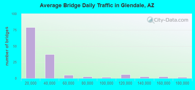
- 3,871,220Total average daily traffic
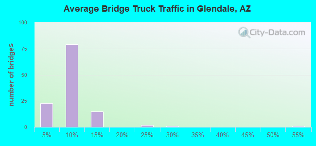
- 247,006Total average daily truck traffic
- National Bridge Inventory (NBI) Registered Bridges for Glendale
- No street view available for this location
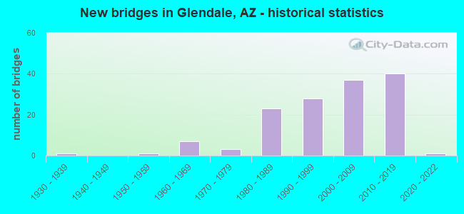
- New bridges - historical statistics
- 11930-1939
- 11950-1959
- 71960-1969
- 31970-1979
- 231980-1989
- 281990-1999
- 372000-2009
- 402010-2019
- 12020-2022
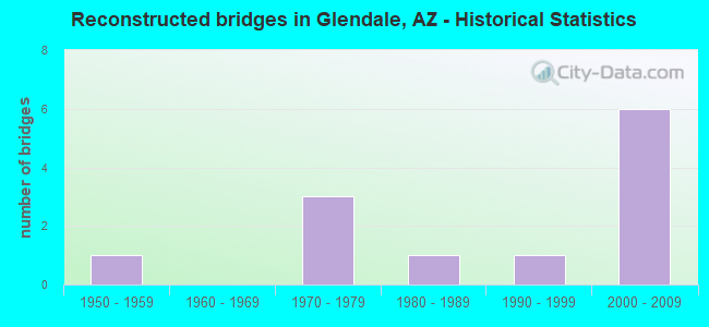
- Reconstructed bridges - Historical Statistics
- 11950-1959
- 01960-1969
- 31970-1979
- 11980-1989
- 11990-1999
- 62000-2009
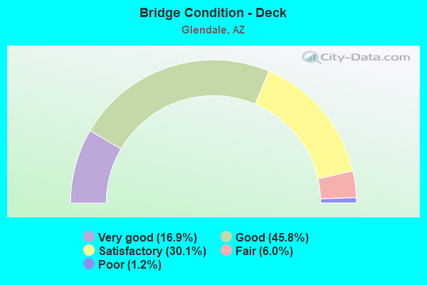
- Bridge Condition - Deck
- 16.9%Very good
- 45.8%Good
- 30.1%Satisfactory
- 6.0%Fair
- 1.2%Poor
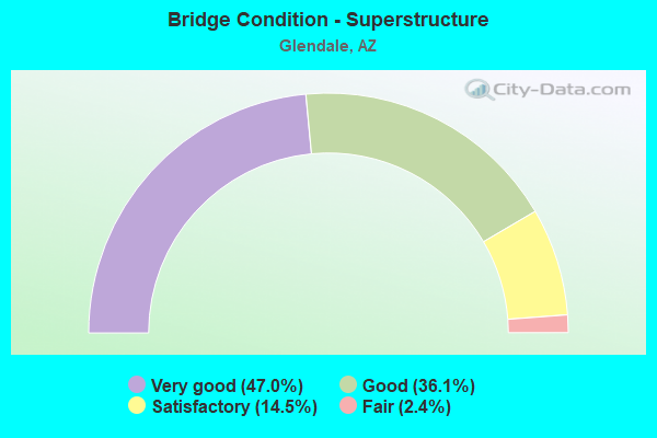
- Bridge Condition - Superstructure
- 47.0%Very good
- 36.1%Good
- 14.5%Satisfactory
- 2.4%Fair
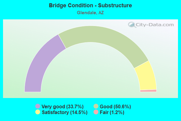
- Bridge Condition - Substructure
- 33.7%Very good
- 50.6%Good
- 14.5%Satisfactory
- 1.2%Fair
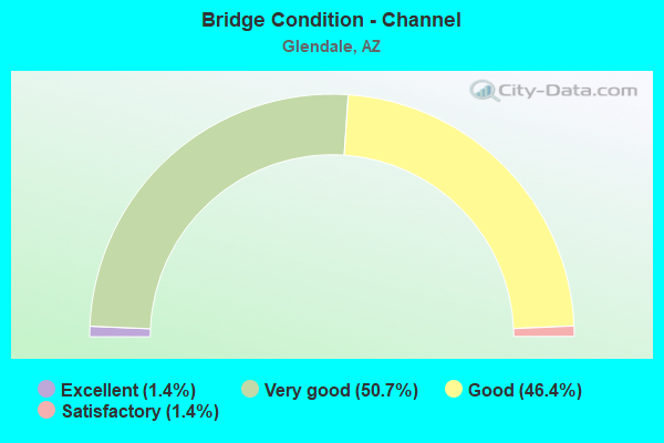
- Bridge Condition - Channel
- 1.4%Excellent
- 50.7%Very good
- 46.4%Good
- 1.4%Satisfactory
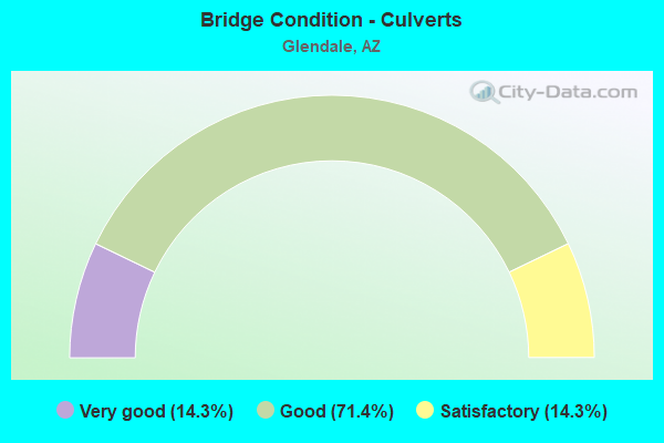
- Bridge Condition - Culverts
- 14.3%Very good
- 71.4%Good
- 14.3%Satisfactory
Find on map >> Show street view
Structure Number: 11008, Location: 0.5 mi N of Northern Ave (Lat: 33.559800, Lng: -112.393500), Route carried "on" structure: City street , Year Built: 2009, Year Reconstructed: 2013, Status: Open, Structure Length: 0.98m (3.22ft), Average Daily Traffic: 2,272 (year 2018), Truck Traffic: 20%, Average Future Daily Traffic: 2,282 (year 2038), Design Load: HS 20, Features Intersected: Reems Road Channel, Facility Carried by Structure: Reems Rd
Minimum Vertical Clearance: 30+ m (98+ ft), Kilometerpoint: 0.000, Lanes on structure: 3, Owner: City or Municipal Highway Agency, Approaching Roadway Width: 24.4m (80.1ft), Material/Design: Concrete continuous, Design/Construction: Culvert, Number Of Spans In Main Unit: 3, Length of Maximum Span: 3.0m (9.8ft), Curb-To-Curb Width: 16.8m (55.1ft), Out-to-Out Width: 39.6m (129.9ft)
Condition: Channel: Very good, Culverts: Good, Operating Rating: 89.8 metric tons, Method Used To Determine Operating Rating: Load Factor (LF), Inventory Rating: 81.6 metric tons, Method Used To Determine Inventory Rating: Load Factor (LF), Structural Evaluation: Better than present minimum criteria, Deck Geometry: Superior to present desirable criteria, Waterway Adequacy: Equal to present desirable criteria, Approach Roadway Alignment: Equal to present desirable criteria, Designated Inspection Frequency: Every 48 months, Inspection Date: April 2020
Find on map >> Show street view
Structure Number: 11009, Location: W of Reems Road (Lat: 33.566086, Lng: -112.394144), Route carried "on" structure: County highway , Year Built: 2009, Status: Open, Structure Length: 0.64m (2.10ft), Average Daily Traffic: 5,824 (year 2019), Truck Traffic: 10%, Average Future Daily Traffic: 5,834 (year 2039), Design Load: HS 20, Features Intersected: Reems Road Channel, Facility Carried by Structure: Olive Ave & BNSFRR
Minimum Vertical Clearance: 30+ m (98+ ft), Kilometerpoint: 0.000, Lanes on structure: 2, Owner: County Highway Agency, Approaching Roadway Width: 8.5m (27.9ft), Material/Design: Concrete, Design/Construction: Culvert, Number Of Spans In Main Unit: 2, Length of Maximum Span: 3.0m (9.8ft)
Condition: Channel: Good, Culverts: Good, Operating Rating: 90.3 metric tons, Method Used To Determine Operating Rating: Load Factor (LF), Inventory Rating: 54.1 metric tons, Method Used To Determine Inventory Rating: Load Factor (LF), Structural Evaluation: Better than present minimum criteria, Waterway Adequacy: Equal to present desirable criteria, Approach Roadway Alignment: Equal to present desirable criteria, Designated Inspection Frequency: Every 48 months, Inspection Date: December 2020
Find on map >> Show street view
Structure Number: 1116, Location: 1.0 mi W Jct Reems Rd (Lat: 33.558800, Lng: -112.409900), Route carried "on" structure: City street , Year Built: 2013, Status: Open, Structure Length: 6.19m (20.31ft), Average Daily Traffic: 9,241 (year 2019), Truck Traffic: 10%, Average Future Daily Traffic: 9,251 (year 2039), Design Load: HL 93, Features Intersected: Sarival Avenue, Facility Carried by Structure: Northern Parkway
Minimum Vertical Clearance: 30+ m (98+ ft), Kilometerpoint: 0.000, Lanes on structure: 2, Lanes under structure: 4, Owner: City or Municipal Highway Agency, Approaching Roadway Width: 14.0m (45.9ft), Material/Design: Prestressed concrete continuous, Design/Construction: Stringer/Multi-beam, Number Of Spans In Main Unit: 2, Length of Maximum Span: 32.3m (106.0ft), Curb-To-Curb Width: 14.0m (45.9ft), Out-to-Out Width: 14.9m (48.9ft)
Condition: Deck: Very good, Superstructure: Very good, Substructure: Very good, Operating Rating: 67.1 metric tons, Method Used To Determine Operating Rating: Load Factor (LF), Inventory Rating: 32.7 metric tons, Method Used To Determine Inventory Rating: Load Factor (LF), Structural Evaluation: Equal to present desirable criteria, Deck Geometry: Superior to present desirable criteria, Underclear: Superior to present desirable criteria, Approach Roadway Alignment: Equal to present desirable criteria, Designated Inspection Frequency: Every 24 months, Inspection Date: May 2020, Deck Structure Type: Concrete Cast-file-Place, Wearing Surface/Protective System: Wearing Surface: Monolithic Concrete
Find on map >> Show street view
Structure Number: 11161, Location: 1.0 mi W Jct Reems Rd (Lat: 33.559300, Lng: -112.409900), Route carried "on" structure: Ramp City street , Year Built: 2013, Status: Open, Structure Length: 6.10m (20.01ft), Average Daily Traffic: 8,565 (year 2019), Truck Traffic: 10%, Average Future Daily Traffic: 8,575 (year 2039), Design Load: HL 93, Features Intersected: Sarival Avenue, Facility Carried by Structure: Northern Parkway
Minimum Vertical Clearance: 30+ m (98+ ft), Kilometerpoint: 0.000, Lanes on structure: 2, Lanes under structure: 4, Owner: City or Municipal Highway Agency, Approaching Roadway Width: 12.2m (40.0ft), Material/Design: Prestressed concrete continuous, Design/Construction: Stringer/Multi-beam, Number Of Spans In Main Unit: 2, Length of Maximum Span: 31.7m (104.0ft), Curb-To-Curb Width: 12.2m (40.0ft), Out-to-Out Width: 13.0m (42.7ft)
Condition: Deck: Good, Superstructure: Very good, Substructure: Very good, Operating Rating: 73.5 metric tons, Method Used To Determine Operating Rating: Load Factor (LF), Inventory Rating: 32.7 metric tons, Method Used To Determine Inventory Rating: Load Factor (LF), Structural Evaluation: Equal to present desirable criteria, Deck Geometry: Superior to present desirable criteria, Underclear: Superior to present desirable criteria, Approach Roadway Alignment: Equal to present desirable criteria, Designated Inspection Frequency: Every 24 months, Inspection Date: May 2020, Deck Structure Type: Concrete Cast-file-Place, Wearing Surface/Protective System: Wearing Surface: Monolithic Concrete
Find on map >> Show street view
Structure Number: 11162, Location: 1.0 mi E Jct Sarival Rd (Lat: 33.559300, Lng: -112.394300), Route carried "on" structure: City street , Year Built: 2014, Status: Open, Structure Length: 10.67m (35.01ft), Average Daily Traffic: 17,806 (year 2019), Truck Traffic: 5%, Average Future Daily Traffic: 17,816 (year 2039), Design Load: HL 93, Features Intersected: Reems Rd, Facility Carried by Structure: Northern Pkwy
Minimum Vertical Clearance: 30+ m (98+ ft), Kilometerpoint: 0.000, Lanes on structure: 4, Lanes under structure: 5, Owner: City or Municipal Highway Agency, Approaching Roadway Width: 25.6m (84.0ft), Skew: 30 degrees, Material/Design: Prestressed concrete continuous, Design/Construction: Stringer/Multi-beam, Number Of Spans In Main Unit: 3, Length of Maximum Span: 35.1m (115.2ft), Curb-To-Curb Width: 36.1m (118.4ft), Out-to-Out Width: 38.0m (124.7ft)
Condition: Deck: Good, Superstructure: Very good, Substructure: Very good, Operating Rating: 87.1 metric tons, Method Used To Determine Operating Rating: Load Factor (LF), Inventory Rating: 32.7 metric tons, Method Used To Determine Inventory Rating: Load Factor (LF), Structural Evaluation: Equal to present desirable criteria, Deck Geometry: Superior to present desirable criteria, Underclear: Superior to present desirable criteria, Approach Roadway Alignment: Equal to present desirable criteria, Designated Inspection Frequency: Every 24 months, Inspection Date: May 2020, Deck Structure Type: Concrete Cast-file-Place, Wearing Surface/Protective System: Wearing Surface: Monolithic Concrete
Find on map >> Show street view
Structure Number: 11163, Location: 2.0 mi E Jct Reems Rd (Lat: 33.557800, Lng: -112.359300), Route carried "on" structure: City street , Year Built: 2014, Status: Open, Structure Length: 5.76m (18.90ft), Average Daily Traffic: 20,711 (year 2019), Truck Traffic: 10%, Average Future Daily Traffic: 20,721 (year 2039), Design Load: HL 93, Features Intersected: Litchfield Rd, Facility Carried by Structure: Northern Parkway
Minimum Vertical Clearance: 30.18m (99.02ft), Kilometerpoint: 0.000, Lanes on structure: 4, Lanes under structure: 8, Owner: City or Municipal Highway Agency, Approaching Roadway Width: 25.6m (84.0ft), Skew: 30 degrees, Material/Design: Prestressed concrete continuous, Design/Construction: Box Beam or Girders - Multiple, Number Of Spans In Main Unit: 2, Length of Maximum Span: 28.0m (91.9ft), Curb-To-Curb Width: 36.1m (118.4ft), Out-to-Out Width: 38.1m (125.0ft)
Condition: Deck: Good, Superstructure: Very good, Substructure: Very good, Operating Rating: 78.9 metric tons, Method Used To Determine Operating Rating: Load Factor (LF), Inventory Rating: 47.2 metric tons, Method Used To Determine Inventory Rating: Load Factor (LF), Structural Evaluation: Equal to present desirable criteria, Deck Geometry: Superior to present desirable criteria, Underclear: Superior to present desirable criteria, Approach Roadway Alignment: Equal to present desirable criteria, Designated Inspection Frequency: Every 24 months, Inspection Date: May 2020, Deck Structure Type: Concrete Cast-file-Place, Wearing Surface/Protective System: Wearing Surface: Monolithic Concrete
Find on map >> Show street view
Structure Number: 11164, Location: 0.5 mi W Jct Ltchfield Rd (Lat: 33.558000, Lng: -112.367800), Route carried "on" structure: City street , Year Built: 2013, Status: Open, Structure Length: 4.30m (14.11ft), Average Daily Traffic: 20,711 (year 2019), Truck Traffic: 10%, Average Future Daily Traffic: 20,721 (year 2039), Design Load: HL 93, Features Intersected: BNSF Spur Track, Facility Carried by Structure: Northern Parkway
Minimum Vertical Clearance: 30+ m (98+ ft), Kilometerpoint: 0.000, Lanes on structure: 5, Owner: City or Municipal Highway Agency, Approaching Roadway Width: 29.3m (96.1ft), Skew: 30 degrees, Material/Design: Prestressed concrete, Design/Construction: Stringer/Multi-beam, Number Of Spans In Main Unit: 1, Length of Maximum Span: 41.5m (136.2ft), Curb-To-Curb Width: 39.8m (130.6ft), Out-to-Out Width: 41.7m (136.8ft)
Condition: Deck: Good, Superstructure: Very good, Substructure: Good, Channel: Very good, Operating Rating: 81.6 metric tons, Method Used To Determine Operating Rating: Load Factor (LF), Inventory Rating: 32.7 metric tons, Method Used To Determine Inventory Rating: Load Factor (LF), Structural Evaluation: Better than present minimum criteria, Deck Geometry: Superior to present desirable criteria, Underclear: Superior to present desirable criteria, Waterway Adequacy: Equal to present desirable criteria, Approach Roadway Alignment: Equal to present desirable criteria, Designated Inspection Frequency: Every 24 months, Inspection Date: May 2020, Deck Structure Type: Concrete Cast-file-Place, Wearing Surface/Protective System: Wearing Surface: Monolithic Concrete
Find on map >> Show street view
Structure Number: 1136, Location: 0.5 mi W of Dysart (Lat: 33.552200, Lng: -112.350000), Route carried "on" structure: County highway , Year Built: 2013, Status: Open, Structure Length: 0.70m (2.30ft), Average Daily Traffic: 19,700 (year 2018), Truck Traffic: 10%, Average Future Daily Traffic: 19,710 (year 2038), Design Load: HL 93, Features Intersected: 135th Ave Channel, Facility Carried by Structure: Northern Pkwy
Minimum Vertical Clearance: 30+ m (98+ ft), Kilometerpoint: 0.000, Lanes on structure: 6, Owner: City or Municipal Highway Agency, Approaching Roadway Width: 31.7m (104.0ft), Skew: 12 degrees, Material/Design: Concrete continuous, Design/Construction: Culvert, Number Of Spans In Main Unit: 2, Length of Maximum Span: 3.0m (9.8ft)
Condition: Channel: Good, Culverts: Good, Operating Rating: 89.8 metric tons, Method Used To Determine Operating Rating: Load Factor (LF), Inventory Rating: 62.6 metric tons, Method Used To Determine Inventory Rating: Load Factor (LF), Structural Evaluation: Better than present minimum criteria, Waterway Adequacy: Equal to present desirable criteria, Approach Roadway Alignment: Equal to present desirable criteria, Designated Inspection Frequency: Every 48 months, Inspection Date: April 2020
Find on map >> Show street view
Structure Number: 11643, Location: 0.5 mi E of Dysart Rd (Lat: 33.550700, Lng: -112.333000), Route carried "on" structure: County highway , Year Built: 2020, Status: Open, Structure Length: 1.77m (5.81ft), Average Daily Traffic: 19,700 (year 2018), Truck Traffic: 20%, Average Future Daily Traffic: 19,710 (year 2040), Design Load: HS 20, Features Intersected: Wash, Facility Carried by Structure: Northern Pkwy
Minimum Vertical Clearance: 30+ m (98+ ft), Kilometerpoint: 0.000, Lanes on structure: 4, Owner: County Highway Agency, Approaching Roadway Width: 29.3m (96.1ft), Skew: 14 degrees, Material/Design: Concrete continuous, Design/Construction: Culvert, Number Of Spans In Main Unit: 5, Length of Maximum Span: 3.4m (11.2ft), Curb or Sidewalk Widths: Left: 1.8m (5.9ft), Right: 1.8m (5.9ft)
Condition: Channel: Very good, Culverts: Very good, Operating Rating: 89.1 metric tons, Method Used To Determine Operating Rating: Load Factor (LF), Inventory Rating: 53.3 metric tons, Method Used To Determine Inventory Rating: Load Factor (LF), Structural Evaluation: Equal to present desirable criteria, Waterway Adequacy: Equal to present desirable criteria, Approach Roadway Alignment: Equal to present desirable criteria, Designated Inspection Frequency: Every 48 months, Inspection Date: January 2021
Find on map >> Show street view
Structure Number: 20006, Location: 6 miles N of I-10 (Lat: 33.551400, Lng: -112.418100), Route carried "on" structure: State highway 303, Year Built: 2013, Status: Open, Structure Length: 7.10m (23.29ft), Average Daily Traffic: 28,201 (year 2018), Truck Traffic: 5%, Average Future Daily Traffic: 28,211 (year 2038), Design Load: HL 93, Features Intersected: Northern Ave
Minimum Vertical Clearance: 30+ m (98+ ft), Kilometerpoint: 177.237, Lanes on structure: 4, Lanes under structure: 4, Owner: State Highway Agency, Approaching Roadway Width: 29.0m (95.1ft), Material/Design: Prestressed concrete continuous, Design/Construction: Stringer/Multi-beam, Number Of Spans In Main Unit: 2, Length of Maximum Span: 36.0m (118.1ft), Curb-To-Curb Width: 29.0m (95.1ft), Out-to-Out Width: 30.0m (98.4ft)
Condition: Deck: Good, Superstructure: Very good, Substructure: Good, Operating Rating: 89.8 metric tons, Method Used To Determine Operating Rating: Load Factor (LF), Inventory Rating: 33.6 metric tons, Method Used To Determine Inventory Rating: Load Factor (LF), Structural Evaluation: Better than present minimum criteria, Deck Geometry: Superior to present desirable criteria, Underclear: Superior to present desirable criteria, Approach Roadway Alignment: Equal to present desirable criteria, Designated Inspection Frequency: Every 24 months, Inspection Date: June 2021, Deck Structure Type: Concrete Cast-file-Place, Wearing Surface/Protective System: Wearing Surface: Bituminous
Find on map >> Show street view
Structure Number: 20007, Location: 6 miles N of I-10 (Lat: 33.551400, Lng: -112.418400), Route carried "on" structure: State highway 303, Year Built: 2013, Status: Open, Structure Length: 7.10m (23.29ft), Average Daily Traffic: 27,485 (year 2018), Truck Traffic: 5%, Average Future Daily Traffic: 27,495 (year 2038), Design Load: HL 93, Features Intersected: Northern Avenue
Minimum Vertical Clearance: 30+ m (98+ ft), Kilometerpoint: 177.237, Lanes on structure: 4, Lanes under structure: 4, Owner: State Highway Agency, Approaching Roadway Width: 32.6m (107.0ft), Material/Design: Prestressed concrete continuous, Design/Construction: Stringer/Multi-beam, Number Of Spans In Main Unit: 2, Length of Maximum Span: 36.0m (118.1ft), Curb-To-Curb Width: 32.7m (107.3ft), Out-to-Out Width: 33.6m (110.2ft)
Condition: Deck: Good, Superstructure: Very good, Substructure: Good, Operating Rating: 89.8 metric tons, Method Used To Determine Operating Rating: Load Factor (LF), Inventory Rating: 37.2 metric tons, Method Used To Determine Inventory Rating: Load Factor (LF), Structural Evaluation: Better than present minimum criteria, Deck Geometry: Superior to present desirable criteria, Underclear: Superior to present desirable criteria, Approach Roadway Alignment: Equal to present desirable criteria, Designated Inspection Frequency: Every 24 months, Inspection Date: June 2021, Deck Structure Type: Concrete Cast-file-Place, Wearing Surface/Protective System: Wearing Surface: Bituminous
Find on map >> Show street view
Structure Number: 20008, Location: 6.5 miles N of I-10 (Lat: 33.558800, Lng: -112.418000), Route carried "on" structure: State highway 303, Year Built: 2013, Status: Open, Structure Length: 5.64m (18.50ft), Average Daily Traffic: 27,649 (year 2018), Truck Traffic: 5%, Average Future Daily Traffic: 27,659 (year 2038), Design Load: HL 93, Features Intersected: Northern Parkway
Minimum Vertical Clearance: 30+ m (98+ ft), Kilometerpoint: 178.042, Lanes on structure: 3, Lanes under structure: 3, Owner: State Highway Agency, Approaching Roadway Width: 25.6m (84.0ft), Material/Design: Prestressed concrete continuous, Design/Construction: Stringer/Multi-beam, Number Of Spans In Main Unit: 2, Length of Maximum Span: 27.4m (89.9ft), Curb-To-Curb Width: 25.4m (83.3ft), Out-to-Out Width: 26.4m (86.6ft)
Condition: Deck: Good, Superstructure: Very good, Substructure: Good, Operating Rating: 82.6 metric tons, Method Used To Determine Operating Rating: Load Factor (LF), Inventory Rating: 37.2 metric tons, Method Used To Determine Inventory Rating: Load Factor (LF), Structural Evaluation: Better than present minimum criteria, Deck Geometry: Superior to present desirable criteria, Underclear: Superior to present desirable criteria, Approach Roadway Alignment: Equal to present desirable criteria, Designated Inspection Frequency: Every 24 months, Inspection Date: June 2021, Deck Structure Type: Concrete Cast-file-Place, Wearing Surface/Protective System: Wearing Surface: Bituminous
Find on map >> Show street view
Structure Number: 20009, Location: 6.5 miles N of I-10 (Lat: 33.558700, Lng: -112.418400), Route carried "on" structure: State highway 303, Year Built: 2013, Status: Open, Structure Length: 5.64m (18.50ft), Average Daily Traffic: 27,587 (year 2018), Truck Traffic: 5%, Average Future Daily Traffic: 27,597 (year 2038), Design Load: HL 93, Features Intersected: Northern Parkway
Minimum Vertical Clearance: 30+ m (98+ ft), Kilometerpoint: 178.042, Lanes on structure: 4, Lanes under structure: 4, Owner: State Highway Agency, Approaching Roadway Width: 29.0m (95.1ft), Material/Design: Prestressed concrete continuous, Design/Construction: Stringer/Multi-beam, Number Of Spans In Main Unit: 2, Length of Maximum Span: 27.4m (89.9ft), Curb-To-Curb Width: 29.1m (95.5ft), Out-to-Out Width: 30.1m (98.8ft)
Condition: Deck: Good, Superstructure: Very good, Substructure: Good, Operating Rating: 79.8 metric tons, Method Used To Determine Operating Rating: Load Factor (LF), Inventory Rating: 34.5 metric tons, Method Used To Determine Inventory Rating: Load Factor (LF), Structural Evaluation: Better than present minimum criteria, Deck Geometry: Superior to present desirable criteria, Underclear: Superior to present desirable criteria, Approach Roadway Alignment: Equal to present desirable criteria, Designated Inspection Frequency: Every 24 months, Inspection Date: June 2021, Deck Structure Type: Concrete Cast-file-Place, Wearing Surface/Protective System: Wearing Surface: Bituminous
Find on map >> Show street view
Structure Number: 20011, Location: 7 miles N of I-10 (Lat: 33.565700, Lng: -112.418300), Route carried "on" structure: State highway 303, Year Built: 2013, Status: Open, Structure Length: 10.73m (35.20ft), Average Daily Traffic: 27,587 (year 2018), Truck Traffic: 5%, Average Future Daily Traffic: 27,597 (year 2038), Design Load: HL 93, Features Intersected: Olive Ave/BNSF RR
Minimum Vertical Clearance: 30+ m (98+ ft), Kilometerpoint: 178.814, Lanes on structure: 4, Lanes under structure: 4, Owner: State Highway Agency, Approaching Roadway Width: 29.0m (95.1ft), Material/Design: Prestressed concrete continuous, Design/Construction: Stringer/Multi-beam, Number Of Spans In Main Unit: 3, Length of Maximum Span: 36.0m (118.1ft), Curb-To-Curb Width: 29.0m (95.1ft), Out-to-Out Width: 30.0m (98.4ft)
Condition: Deck: Very good, Superstructure: Very good, Substructure: Good, Operating Rating: 89.8 metric tons, Method Used To Determine Operating Rating: Load Factor (LF), Inventory Rating: 37.2 metric tons, Method Used To Determine Inventory Rating: Load Factor (LF), Structural Evaluation: Better than present minimum criteria, Deck Geometry: Superior to present desirable criteria, Underclear: High priority of corrective action, Approach Roadway Alignment: Equal to present desirable criteria, Designated Inspection Frequency: Every 24 months, Inspection Date: June 2021, Deck Structure Type: Concrete Cast-file-Place, Wearing Surface/Protective System: Wearing Surface: Bituminous
Find on map >> Show street view
Structure Number: 20013, Location: 8 miles N of I-10 (Lat: 33.580400, Lng: -112.418000), Route carried "on" structure: State highway 303, Year Built: 2013, Status: Open, Structure Length: 7.10m (23.29ft), Average Daily Traffic: 26,874 (year 2018), Truck Traffic: 9%, Average Future Daily Traffic: 26,884 (year 2038), Design Load: HL 93, Features Intersected: Peoria Ave
Minimum Vertical Clearance: 30+ m (98+ ft), Kilometerpoint: 180.456, Lanes on structure: 3, Lanes under structure: 4, Owner: State Highway Agency, Approaching Roadway Width: 29.0m (95.1ft), Material/Design: Prestressed concrete continuous, Design/Construction: Stringer/Multi-beam, Number Of Spans In Main Unit: 2, Length of Maximum Span: 36.0m (118.1ft), Curb-To-Curb Width: 29.0m (95.1ft), Out-to-Out Width: 30.0m (98.4ft)
Condition: Deck: Good, Superstructure: Very good, Substructure: Good, Operating Rating: 89.8 metric tons, Method Used To Determine Operating Rating: Load Factor (LF), Inventory Rating: 33.6 metric tons, Method Used To Determine Inventory Rating: Load Factor (LF), Structural Evaluation: Better than present minimum criteria, Deck Geometry: Superior to present desirable criteria, Underclear: Better than present minimum criteria, Approach Roadway Alignment: Equal to present desirable criteria, Designated Inspection Frequency: Every 24 months, Inspection Date: June 2021, Deck Structure Type: Concrete Cast-file-Place, Wearing Surface/Protective System: Wearing Surface: Bituminous
Find on map >> Show street view
Structure Number: 20014, Location: 8 miles N of I-10 (Lat: 33.580400, Lng: -112.418300), Route carried "on" structure: State highway 303, Year Built: 2013, Status: Open, Structure Length: 7.10m (23.29ft), Average Daily Traffic: 27,377 (year 2018), Truck Traffic: 9%, Average Future Daily Traffic: 27,387 (year 2038), Design Load: HL 93, Features Intersected: Peoria Ave
Minimum Vertical Clearance: 30+ m (98+ ft), Kilometerpoint: 180.456, Lanes on structure: 3, Lanes under structure: 4, Owner: State Highway Agency, Approaching Roadway Width: 25.3m (83.0ft), Material/Design: Prestressed concrete continuous, Design/Construction: Stringer/Multi-beam, Number Of Spans In Main Unit: 2, Length of Maximum Span: 36.0m (118.1ft), Curb-To-Curb Width: 25.4m (83.3ft), Out-to-Out Width: 26.3m (86.3ft)
Condition: Deck: Good, Superstructure: Very good, Substructure: Good, Operating Rating: 89.8 metric tons, Method Used To Determine Operating Rating: Load Factor (LF), Inventory Rating: 37.2 metric tons, Method Used To Determine Inventory Rating: Load Factor (LF), Structural Evaluation: Better than present minimum criteria, Deck Geometry: Superior to present desirable criteria, Underclear: Better than present minimum criteria, Approach Roadway Alignment: Equal to present desirable criteria, Designated Inspection Frequency: Every 24 months, Inspection Date: June 2021, Deck Structure Type: Concrete Cast-file-Place, Wearing Surface/Protective System: Wearing Surface: Bituminous
Find on map >> Show street view
Structure Number: 20022, Location: Glendale Avenue (Lat: 33.537100, Lng: -112.418200), Route carried "on" structure: State highway 303, Year Built: 2014, Status: Open, Structure Length: 6.98m (22.90ft), Average Daily Traffic: 52,869 (year 2019), Truck Traffic: 9%, Average Future Daily Traffic: 52,879 (year 2039), Design Load: HL 93, Features Intersected: Glendale Avenue
Minimum Vertical Clearance: 30+ m (98+ ft), Kilometerpoint: 182.049, Lanes on structure: 6, Lanes under structure: 4, Owner: State Highway Agency, Approaching Roadway Width: 57.9m (190.0ft), Skew: 30 degrees, Material/Design: Prestressed concrete continuous, Design/Construction: Stringer/Multi-beam, Number Of Spans In Main Unit: 2, Length of Maximum Span: 34.7m (113.8ft), Curb-To-Curb Width: 58.0m (190.3ft), Out-to-Out Width: 59.9m (196.5ft)
Condition: Deck: Very good, Superstructure: Very good, Substructure: Very good, Operating Rating: 43.7 metric tons, Method Used To Determine Operating Rating: Assigned ratings based on Load and Resistance Factor Design (LRFD) reported by rating factor (RF) using HL93 loadings, Inventory Rating: 36.0 metric tons, Method Used To Determine Inventory Rating: Assigned ratings based on Load and Resistance Factor Design (LRFD) reported by rating factor (RF) using HL93 loadings, Structural Evaluation: Equal to present desirable criteria, Deck Geometry: Superior to present desirable criteria, Underclear: Equal to present minimum criteria, Approach Roadway Alignment: Equal to present desirable criteria, Designated Inspection Frequency: Every 24 months, Inspection Date: June 2021, Deck Structure Type: Concrete Cast-file-Place, Wearing Surface/Protective System: Wearing Surface: Bituminous
Find on map >> Show street view
Structure Number: AFAZNUEX00001, Location: 0.3 MILES NORTH OF NORTH (Lat: 33.548592, Lng: -112.359647), Route carried "on" structure: Federal lands road , Year Built: 1994, Status: Open, Structure Length: 1.13m (3.71ft), Average Daily Traffic: 10 (year 2018), Average Future Daily Traffic: 12 (year 2038), Features Intersected: DYSART DRAINAGE DITCH, Facility Carried by Structure: ACCESS ROAD
Minimum Vertical Clearance: 30+ m (98+ ft), Kilometerpoint: 0.000, Lanes on structure: 2, Owner: Air Force, Approaching Roadway Width: 7.3m (24.0ft), Material/Design: Steel, Design/Construction: Stringer/Multi-beam, Number Of Spans In Main Unit: 1, Length of Maximum Span: 10.4m (34.1ft), Curb-To-Curb Width: 7.4m (24.3ft), Out-to-Out Width: 7.9m (25.9ft)
Condition: Deck: Satisfactory, Superstructure: Good, Substructure: Satisfactory, Channel: Very good, Operating Rating: 53.5 metric tons, Method Used To Determine Operating Rating: Load Factor (LF), Inventory Rating: 31.7 metric tons, Method Used To Determine Inventory Rating: Load Factor (LF), Structural Evaluation: Equal to present minimum criteria, Deck Geometry: Equal to present minimum criteria, Waterway Adequacy: Equal to present desirable criteria, Approach Roadway Alignment: Equal to present desirable criteria, Designated Inspection Frequency: Every 24 months, Inspection Date: September 2020, Bridge Improvement Cost: $50,000, Roadway Improvement Cost: $5,000, Total Project Cost: $75,000 ( Estimate for 2018), Deck Structure Type: Concrete Cast-file-Place, Wearing Surface/Protective System: Wearing Surface: Bituminous
Find on map >> Show street view
Structure Number: AFAZNUEX00002, Location: 0.5 MI NW OF NORTH GATE (Lat: 33.550844, Lng: -112.362800), Route carried "on" structure: Federal lands road , Year Built: 1994, Status: Open, Structure Length: 1.75m (5.74ft), Average Daily Traffic: 10 (year 2018), Average Future Daily Traffic: 12 (year 2038), Features Intersected: DYSART DRAINAGE DITCH, Facility Carried by Structure: ACCESS ROAD
Minimum Vertical Clearance: 30+ m (98+ ft), Kilometerpoint: 0.000, Lanes on structure: 2, Owner: Air Force, Approaching Roadway Width: 32.0m (105.0ft), Material/Design: Concrete, Design/Construction: Culvert, Number Of Spans In Main Unit: 4, Length of Maximum Span: 3.7m (12.1ft)
Condition: Channel: Good, Culverts: Satisfactory, Operating Rating: 36.3 metric tons, Method Used To Determine Operating Rating: Field evaluation and documented engineering judgment, Inventory Rating: 32.7 metric tons, Method Used To Determine Inventory Rating: Field evaluation and documented engineering judgment, Structural Evaluation: Equal to present minimum criteria, Waterway Adequacy: Equal to present desirable criteria, Approach Roadway Alignment: Equal to present desirable criteria, Designated Inspection Frequency: Every 24 months, Inspection Date: September 2020, Deck Structure Type: Concrete Cast-file-Place
Find on map >> Show street view
Structure Number: AFAZNUEX00003, Location: 0.5 MI S OF SUPER SABRE S (Lat: 33.522550, Lng: -112.375353), Route carried "on" structure: Federal lands road , Year Built: 1994, Year Reconstructed: 2005, Status: Open, Structure Length: 0.63m (2.07ft), Average Daily Traffic: 200 (year 2018), Average Future Daily Traffic: 240 (year 2038), Features Intersected: UNNAMED DRAINAGE, Facility Carried by Structure: AMMO ROAD
Minimum Vertical Clearance: 30+ m (98+ ft), Kilometerpoint: 0.000, Lanes on structure: 2, Owner: Air Force, Approaching Roadway Width: 7.9m (25.9ft), Material/Design: Concrete, Design/Construction: Culvert, Number Of Spans In Main Unit: 3, Length of Maximum Span: 1.8m (5.9ft)
Condition: Channel: Good, Culverts: Good, Operating Rating: 36.3 metric tons, Method Used To Determine Operating Rating: Field evaluation and documented engineering judgment, Inventory Rating: 32.7 metric tons, Method Used To Determine Inventory Rating: Field evaluation and documented engineering judgment, Structural Evaluation: Better than present minimum criteria, Waterway Adequacy: Equal to present minimum criteria, Approach Roadway Alignment: Equal to present desirable criteria, Designated Inspection Frequency: Every 24 months, Inspection Date: September 2020, Deck Structure Type: Concrete Cast-file-Place
Find on map >> Show street view
Structure Number: AFAZNUEX00008, Location: 0.7 MI. NORTH OF SOUTH G (Lat: 33.540167, Lng: -112.358556), Route carried "on" structure: Federal lands road , Year Built: 2007, Status: Open, Structure Length: 3.71m (12.17ft), Average Daily Traffic: 5,000 (year 2015), Average Future Daily Traffic: 6,000 (year 2035), Design Load: HS 25 or greater, Features Intersected: N LITCHFIELD ROAD, Facility Carried by Structure: THUNDERBIRD STREET
Minimum Vertical Clearance: 30+ m (98+ ft), Kilometerpoint: 53.977, Lanes on structure: 4, Lanes under structure: 4, Owner: Air Force, Approaching Roadway Width: 17.1m (56.1ft), Material/Design: Prestressed concrete continuous, Design/Construction: Box Beam or Girders - Multiple, Number Of Spans In Main Unit: 2, Length of Maximum Span: 18.5m (60.7ft), Curb or Sidewalk Widths: Left: 1.7m (5.6ft), Right: 1.7m (5.6ft), Curb-To-Curb Width: 17.1m (56.1ft), Out-to-Out Width: 21.1m (69.2ft)
Condition: Deck: Satisfactory, Superstructure: Good, Substructure: Satisfactory, Operating Rating: 79.8 metric tons, Method Used To Determine Operating Rating: Load Factor (LF), Inventory Rating: 48.1 metric tons, Method Used To Determine Inventory Rating: Load Factor (LF), Structural Evaluation: Equal to present minimum criteria, Deck Geometry: Somewhat better than minimum adequacy, Underclear: Superior to present desirable criteria, Approach Roadway Alignment: Equal to present minimum criteria, Designated Inspection Frequency: Every 24 months, Inspection Date: November 2020, Bridge Improvement Cost: $75,000, Roadway Improvement Cost: $8,000, Total Project Cost: $113,000, Deck Structure Type: Concrete Cast-file-Place
Find on map >> Show street view
Structure Number: 2002, Location: 0.4 mi N of Jct US 60 (Lat: 33.652700, Lng: -112.232800), Route carried "under" structure: State highway 101, Year Built: 1990, Structure Length: 0. m, Average Daily Traffic: 100,602 (year 2019), Truck Traffic: 7%, Features Intersected: Loop 101, Facility Carried by Structure: Union Hills Drive
Minimum Vertical Clearance: 5.43m (17.81ft), Kilometerpoint: 25.428, Lanes on structure: 10, Lanes under structure: 10, Material/Design: Prestressed concrete continuous, Design/Construction: Box Beam or Girders - Single/Spread, Length of Maximum Span: 38.1m (125.0ft)
Find on map >> Show street view
Structure Number: 2051, Location: 17.24 mi N of Jct I 10 (Lat: 33.667500, Lng: -112.220400), Route carried "under" structure: State highway 101, Year Built: 1990, Structure Length: 0. m, Average Daily Traffic: 135,200 (year 2019), Truck Traffic: 7%, Features Intersected: Loop 101, Facility Carried by Structure: 75th Avenue
Minimum Vertical Clearance: 5.13m (16.83ft), Kilometerpoint: 27.745, Lanes on structure: 7, Lanes under structure: 7, Material/Design: Prestressed concrete continuous, Design/Construction: Box Beam or Girders - Single/Spread, Length of Maximum Span: 38.1m (125.0ft)
Find on map >> Show street view
Structure Number: 2052, Location: 18.24 mi N of Jct I 10 (Lat: 33.667600, Lng: -112.203000), Route carried "under" structure: State highway 101, Year Built: 1990, Structure Length: 0. m, Average Daily Traffic: 140,119 (year 2019), Truck Traffic: 7%, Features Intersected: Loop 101, Facility Carried by Structure: 67th Avenue
Minimum Vertical Clearance: 5.23m (17.16ft), Kilometerpoint: 29.354, Lanes on structure: 7, Lanes under structure: 7, Material/Design: Prestressed concrete continuous, Design/Construction: Box Beam or Girders - Single/Spread, Length of Maximum Span: 40.5m (132.9ft)
Find on map >> Show street view
Structure Number: 2053, Location: 4.21 mi W of Jct I 17 (Lat: 33.667800, Lng: -112.186700), Route carried "under" structure: State highway 101, Year Built: 1990, Structure Length: 0. m, Average Daily Traffic: 140,119 (year 2019), Truck Traffic: 7%, Features Intersected: SL 101, Facility Carried by Structure: 59th Avenue
Minimum Vertical Clearance: 5.15m (16.90ft), Kilometerpoint: 30.867, Lanes on structure: 7, Lanes under structure: 7, Material/Design: Prestressed concrete continuous, Design/Construction: Box Beam or Girders - Single/Spread, Length of Maximum Span: 39.0m (128.0ft)
Find on map >> Show street view
Structure Number: 206, Location: 3.3 mi N of Jct US 60 (Lat: 33.643700, Lng: -112.235700), Route carried "under" structure: State highway 101, Year Built: 1990, Structure Length: 0. m, Average Daily Traffic: 97,728 (year 2019), Truck Traffic: 7%, Features Intersected: Loop 101, Facility Carried by Structure: 83rd Avenue
Minimum Vertical Clearance: 5.33m (17.49ft), Kilometerpoint: 24.333, Lanes on structure: 4, Lanes under structure: 4, Material/Design: Prestressed concrete continuous, Design/Construction: Box Beam or Girders - Single/Spread, Length of Maximum Span: 52.4m (171.9ft)
Find on map >> Show street view
Structure Number: 2069, Location: 20.19 mi N of Jct I 10 (Lat: 33.668400, Lng: -112.169600), Route carried "under" structure: City street , Year Built: 1992, Structure Length: 0. m, Average Daily Traffic: 15,549 (year 2020), Truck Traffic: 1%, Features Intersected: 51st Avenue, Facility Carried by Structure: SL 101
Minimum Vertical Clearance: 5.30m (17.39ft), Kilometerpoint: 0.000, Lanes on structure: 8, Lanes under structure: 8, Material/Design: Prestressed concrete, Design/Construction: Box Beam or Girders - Multiple, Length of Maximum Span: 30.5m (100.1ft)
Find on map >> Show street view
Structure Number: 2083, Location: 6.96 mi N Jct I-10 (Lat: 33.536900, Lng: -112.269600), Route carried "under" structure: City street , Year Built: 1999, Structure Length: 0. m, Average Daily Traffic: 25,500 (year 2018), Truck Traffic: 3%, Features Intersected: Glendale Ave, Facility Carried by Structure: Loop 101 NB
Minimum Vertical Clearance: 5.25m (17.22ft), Kilometerpoint: 0.000, Lanes on structure: 4, Lanes under structure: 4, Material/Design: Prestressed concrete, Design/Construction: Box Beam or Girders - Single/Spread, Length of Maximum Span: 63.1m (207.0ft)
Find on map >> Show street view
Structure Number: 2321, Location: SR101/Union Hills Dr (Lat: 33.653000, Lng: -112.232800), Route carried "under" structure: State highway 101, Year Built: 2010, Structure Length: 0. m, Average Daily Traffic: 98,726 (year 2018), Truck Traffic: 7%, Features Intersected: SR101, Facility Carried by Structure: Beardsley Ramp D
Minimum Vertical Clearance: 5.18m (16.99ft), Kilometerpoint: 25.428, Lanes on structure: 1, Lanes under structure: 8, Material/Design: Prestressed concrete continuous, Design/Construction: Box Beam or Girders - Multiple, Length of Maximum Span: 38.1m (125.0ft)
Find on map >> Show street view
Structure Number: 2545, Location: 6.96 mi N Jct I-10 (Lat: 33.536900, Lng: -112.269900), Route carried "under" structure: City street , Year Built: 1999, Structure Length: 0. m, Average Daily Traffic: 25,500 (year 2018), Truck Traffic: 3%, Features Intersected: Glendale Ave, Facility Carried by Structure: Loop 101 SB
Minimum Vertical Clearance: 5.37m (17.62ft), Kilometerpoint: 0.000, Lanes on structure: 4, Lanes under structure: 4, Material/Design: Prestressed concrete, Design/Construction: Box Beam or Girders - Single/Spread, Length of Maximum Span: 63.1m (207.0ft)
Find on map >> Show street view
Structure Number: 2546, Location: 6 mi North of I 10 (Lat: 33.522500, Lng: -112.268900), Route carried "under" structure: City street , Year Built: 2000, Structure Length: 0. m, Average Daily Traffic: 3,900 (year 2018), Truck Traffic: 5%, Features Intersected: B. Home Rd. & canals, Facility Carried by Structure: Loop 101 NB
Minimum Vertical Clearance: 5.79m (19.00ft), Kilometerpoint: 0.000, Lanes on structure: 4, Lanes under structure: 4, Material/Design: Prestressed concrete continuous, Design/Construction: Stringer/Multi-beam, Length of Maximum Span: 39.9m (130.9ft)
Find on map >> Show street view
Structure Number: 2547, Location: 6 mi North of I 10 (Lat: 33.522500, Lng: -112.269200), Route carried "under" structure: City street , Year Built: 2000, Structure Length: 0. m, Average Daily Traffic: 3,900 (year 2018), Truck Traffic: 5%, Features Intersected: B. Home Rd & canals, Facility Carried by Structure: Loop 101 SB
Minimum Vertical Clearance: 5.30m (17.39ft), Kilometerpoint: 0.000, Lanes on structure: 4, Lanes under structure: 4, Material/Design: Prestressed concrete continuous, Design/Construction: Stringer/Multi-beam, Length of Maximum Span: 39.9m (130.9ft)
Find on map >> Show street view
Structure Number: 265, Location: B. Home @ 51st Ave (Lat: 33.523800, Lng: -112.169200), Route carried "under" structure: US 60, Year Built: 2004, Structure Length: 0. m, Average Daily Traffic: 72,477 (year 2019), Truck Traffic: 9%, Features Intersected: Grand Ave & Bethany Home, Facility Carried by Structure: 51st Avenue
Minimum Vertical Clearance: 8.02m (26.31ft), Kilometerpoint: 251.347, Lanes on structure: 5, Lanes under structure: 13, Material/Design: Prestressed concrete continuous, Design/Construction: Stringer/Multi-beam, Length of Maximum Span: 53.9m (176.8ft)
Find on map >> Show street view
Structure Number: 2651, Location: 43rd Ave @ Camelback Rd (Lat: 33.511600, Lng: -112.153700), Route carried "under" structure: Ramp US 60, Year Built: 2004, Structure Length: 0. m, Average Daily Traffic: 4,380 (year 2015), Truck Traffic: 5%, Features Intersected: Grand Avenue Ramp
Minimum Vertical Clearance: 4.97m (16.31ft), Kilometerpoint: 0.000, Lanes on structure: 6, Lanes under structure: 6, Material/Design: Concrete, Design/Construction: Frame, Length of Maximum Span: 10.7m (35.1ft)
Find on map >> Show street view
Structure Number: 2652, Location: 43rd Ave @ Camelback (Lat: 33.510200, Lng: -112.151900), Route carried "under" structure: City street , Year Built: 2004, Structure Length: 0. m, Average Daily Traffic: 65,706 (year 2019), Truck Traffic: 5%, Features Intersected: 43rd Ave & Camelback, Facility Carried by Structure: US 60
Minimum Vertical Clearance: 6.76m (22.18ft), Kilometerpoint: 0.000, Lanes on structure: 3, Lanes under structure: 16, Material/Design: Prestressed concrete continuous, Design/Construction: Stringer/Multi-beam, Length of Maximum Span: 42.7m (140.1ft)
Find on map >> Show street view
Structure Number: 2653, Location: 43rd Ave @ Camelback (Lat: 33.510400, Lng: -112.151900), Route carried "under" structure: City street , Year Built: 2004, Structure Length: 0. m, Average Daily Traffic: 65,706 (year 2019), Truck Traffic: 5%, Features Intersected: 43rd Ave & Camelback Rd, Facility Carried by Structure: US 60
Minimum Vertical Clearance: 7.02m (23.03ft), Kilometerpoint: 0.000, Lanes on structure: 3, Lanes under structure: 16, Material/Design: Prestressed concrete continuous, Design/Construction: Stringer/Multi-beam, Length of Maximum Span: 42.4m (139.1ft)
Find on map >> Show street view
Structure Number: 2698, Location: 59th Av/Glendale Ave/US60 (Lat: 33.538600, Lng: -112.186300), Route carried "under" structure: US 60, Year Built: 2007, Structure Length: 0. m, Average Daily Traffic: 45,134 (year 2019), Truck Traffic: 9%, Features Intersected: US 60, Facility Carried by Structure: 59th Ave/Glendale
Minimum Vertical Clearance: 5.29m (17.36ft), Kilometerpoint: 249.126, Lanes on structure: 5, Lanes under structure: 6, Material/Design: Prestressed concrete, Design/Construction: Stringer/Multi-beam, Length of Maximum Span: 28.3m (92.8ft)
Find on map >> Show street view
Structure Number: 2699, Location: 67th Ave @ Northern (Lat: 33.552100, Lng: -112.203600), Route carried "under" structure: US 60, Year Built: 2005, Structure Length: 0. m, Average Daily Traffic: 47,879 (year 2019), Truck Traffic: 4%, Features Intersected: Northern Ave & RR, Facility Carried by Structure: 67th Ave
Minimum Vertical Clearance: 7.39m (24.25ft), Kilometerpoint: 246.712, Lanes on structure: 4, Lanes under structure: 15, Material/Design: Prestressed concrete continuous, Design/Construction: Stringer/Multi-beam, Length of Maximum Span: 41.8m (137.1ft)
Find on map >> Show street view
Structure Number: 2707, Location: Maryland @ 55th Ave (Lat: 33.531800, Lng: -112.178800), Route carried "under" structure: US 60, Year Built: 2004, Structure Length: 0. m, Average Daily Traffic: 45,134 (year 2019), Truck Traffic: 9%, Features Intersected: 55th Ave & US 60, Facility Carried by Structure: Maryland Avenue
Minimum Vertical Clearance: 7.50m (24.61ft), Kilometerpoint: 249.931, Lanes on structure: 2, Lanes under structure: 7, Material/Design: Prestressed concrete continuous, Design/Construction: Stringer/Multi-beam, Length of Maximum Span: 54.3m (178.1ft)
Find on map >> Show street view
Structure Number: 2851, Location: 0.5 mi S Glendale Ave (Lat: 33.530100, Lng: -112.269700), Route carried "under" structure: State highway 101, Year Built: 2007, Structure Length: 0. m, Average Daily Traffic: 117,867 (year 2019), Truck Traffic: 7%, Features Intersected: 101L, Facility Carried by Structure: Maryland Ave
Minimum Vertical Clearance: 5.22m (17.13ft), Kilometerpoint: 10.461, Lanes on structure: 5, Lanes under structure: 10, Material/Design: Prestressed concrete continuous, Design/Construction: Stringer/Multi-beam, Length of Maximum Span: 39.9m (130.9ft)
Find on map >> Show street view
Structure Number: 2969, Location: 4.3 mi N I-10 (Lat: 33.522400, Lng: -112.418500), Route carried "under" structure: City street , Year Built: 2014, Structure Length: 0. m, Average Daily Traffic: 1,278 (year 2019), Truck Traffic: 5%, Features Intersected: Bethany Home Rd, Facility Carried by Structure: SR 303L
Minimum Vertical Clearance: 5.41m (17.75ft), Kilometerpoint: 0.000, Lanes on structure: 3, Lanes under structure: 4, Material/Design: Prestressed concrete continuous, Design/Construction: Stringer/Multi-beam, Length of Maximum Span: 34.7m (113.8ft)
Find on map >> Show street view
Structure Number: 297, Location: 4.3 mi N I-10 (Lat: 33.522400, Lng: -112.418800), Route carried "under" structure: City street , Year Built: 2014, Structure Length: 0. m, Average Daily Traffic: 1,278 (year 2019), Truck Traffic: 5%, Features Intersected: Bethany Home Rd, Facility Carried by Structure: SR 303L
Minimum Vertical Clearance: 5.41m (17.75ft), Kilometerpoint: 0.000, Lanes on structure: 3, Lanes under structure: 4, Material/Design: Prestressed concrete continuous, Design/Construction: Stringer/Multi-beam, Length of Maximum Span: 34.7m (113.8ft)
Find on map >> Show street view
Structure Number: 9301, Location: 0.2 mi E Jct El Mirage Rd (Lat: 33.536500, Lng: -112.320400), Route carried "under" structure: ServiceOther road , Year Built: 1973, Structure Length: 0. m, Average Daily Traffic: 10 (year 2020), Truck Traffic: 50%, Features Intersected: Agua Fria River, Facility Carried by Structure: Glendale Avenue
Minimum Vertical Clearance: 4.42m (14.50ft), Kilometerpoint: 0.000, Lanes on structure: 4, Lanes under structure: 4, Material/Design: Prestressed concrete continuous, Design/Construction: Stringer/Multi-beam, Length of Maximum Span: 30.5m (100.1ft)
Find on map >> Show street view
Structure Number: 10604, Location: 300' E Jct 63rd Ave (Lat: 33.667800, Lng: -112.194100), Route carried "under" structure: _, Year Built: 2011, Structure Length: 0. m, Features Intersected: Multiuse Path, Facility Carried by Structure: Beardsley
Minimum Vertical Clearance: 4.88m (16.01ft), Kilometerpoint: 0.000, Lanes on structure: 2, Material/Design: Prestressed concrete, Design/Construction: Box Beam or Girders - Multiple, Length of Maximum Span: 13.4m (44.0ft)
Find on map >> Show street view
Structure Number: 10605, Location: Jct 101L & 63rd Ave (Lat: 33.667900, Lng: -112.195100), Route carried "under" structure: State highway 101, Year Built: 2011, Structure Length: 0. m, Average Daily Traffic: 144,710 (year 2018), Truck Traffic: 7%, Features Intersected: 101L, Facility Carried by Structure: 63rd Avenue
Minimum Vertical Clearance: 6.21m (20.37ft), Kilometerpoint: 30.256, Lanes under structure: 8, Material/Design: Steel, Design/Construction: Stayed Girder, Length of Maximum Span: 39.6m (129.9ft)
Find on map >> Show street view
Structure Number: 1116, Location: 1.0 mi W Jct Reems Rd (Lat: 33.558800, Lng: -112.409900), Route carried "under" structure: City street , Year Built: 2013, Structure Length: 0. m, Average Daily Traffic: 949 (year 2019), Truck Traffic: 2%, Features Intersected: Sarival Avenue, Facility Carried by Structure: Northern Parkway
Minimum Vertical Clearance: 6.87m (22.54ft), Kilometerpoint: 0.000, Lanes on structure: 2, Lanes under structure: 4, Material/Design: Prestressed concrete continuous, Design/Construction: Stringer/Multi-beam, Length of Maximum Span: 32.3m (106.0ft)
Find on map >> Show street view
Structure Number: 11161, Location: 1.0 mi W Jct Reems Rd (Lat: 33.559300, Lng: -112.409900), Route carried "under" structure: City street , Year Built: 2013, Structure Length: 0. m, Average Daily Traffic: 949 (year 2019), Truck Traffic: 5%, Features Intersected: Sarival Avenue, Facility Carried by Structure: Northern Parkway
Minimum Vertical Clearance: 6.51m (21.36ft), Kilometerpoint: 0.000, Lanes on structure: 2, Lanes under structure: 4, Material/Design: Prestressed concrete continuous, Design/Construction: Stringer/Multi-beam, Length of Maximum Span: 31.7m (104.0ft)
Find on map >> Show street view
Structure Number: 11162, Location: 1.0 mi E Jct Sarival Rd (Lat: 33.559300, Lng: -112.394300), Route carried "under" structure: City street , Year Built: 2014, Structure Length: 0. m, Average Daily Traffic: 10,071 (year 2019), Truck Traffic: 5%, Features Intersected: Reems Rd, Facility Carried by Structure: Northern Pkwy
Minimum Vertical Clearance: 5.78m (18.96ft), Kilometerpoint: 0.000, Lanes on structure: 4, Lanes under structure: 5, Material/Design: Prestressed concrete continuous, Design/Construction: Stringer/Multi-beam, Length of Maximum Span: 35.1m (115.2ft)
Find on map >> Show street view
Structure Number: 11163, Location: 2.0 mi E Jct Reems Rd (Lat: 33.557800, Lng: -112.359300), Route carried "under" structure: City street , Year Built: 2014, Structure Length: 0. m, Average Daily Traffic: 15,761 (year 2019), Truck Traffic: 5%, Features Intersected: Litchfield Rd, Facility Carried by Structure: Northern Parkway
Minimum Vertical Clearance: 5.23m (17.16ft), Kilometerpoint: 0.000, Lanes on structure: 4, Lanes under structure: 8, Material/Design: Prestressed concrete continuous, Design/Construction: Box Beam or Girders - Multiple, Length of Maximum Span: 28.0m (91.9ft)
Find on map >> Show street view
Structure Number: 20006, Location: 6 miles N of I-10 (Lat: 33.551400, Lng: -112.418100), Route carried "under" structure: City street , Year Built: 2013, Structure Length: 0. m, Average Daily Traffic: 1,520 (year 2018), Features Intersected: Northern Ave, Facility Carried by Structure: SR 303L
Minimum Vertical Clearance: 5.82m (19.09ft), Kilometerpoint: 0.000, Lanes on structure: 4, Lanes under structure: 4, Material/Design: Prestressed concrete continuous, Design/Construction: Stringer/Multi-beam, Length of Maximum Span: 36.0m (118.1ft)
Find on map >> Show street view
Structure Number: 20007, Location: 6 miles N of I-10 (Lat: 33.551400, Lng: -112.418400), Route carried "under" structure: City street , Year Built: 2013, Structure Length: 0. m, Average Daily Traffic: 1,520 (year 2018), Features Intersected: Northern Avenue, Facility Carried by Structure: 303L
Minimum Vertical Clearance: 5.36m (17.59ft), Kilometerpoint: 0.000, Lanes on structure: 4, Lanes under structure: 4, Material/Design: Prestressed concrete continuous, Design/Construction: Stringer/Multi-beam, Length of Maximum Span: 36.0m (118.1ft)
Find on map >> Show street view
Structure Number: 20008, Location: 6.5 miles N of I-10 (Lat: 33.558800, Lng: -112.418000), Route carried "under" structure: Ramp City street , Year Built: 2013, Structure Length: 0. m, Average Daily Traffic: 1,000 (year 2020), Features Intersected: Northern Parkway, Facility Carried by Structure: SR 303L
Minimum Vertical Clearance: 6.24m (20.47ft), Kilometerpoint: 0.000, Lanes on structure: 3, Lanes under structure: 3, Material/Design: Prestressed concrete continuous, Design/Construction: Stringer/Multi-beam, Length of Maximum Span: 27.4m (89.9ft)
Find on map >> Show street view
Structure Number: 20009, Location: 6.5 miles N of I-10 (Lat: 33.558700, Lng: -112.418400), Route carried "under" structure: Ramp City street , Year Built: 2013, Structure Length: 0. m, Average Daily Traffic: 1,000 (year 2020), Features Intersected: Northern Parkway, Facility Carried by Structure: SR303L
Minimum Vertical Clearance: 5.50m (18.04ft), Kilometerpoint: 0.000, Lanes on structure: 4, Lanes under structure: 4, Material/Design: Prestressed concrete continuous, Design/Construction: Stringer/Multi-beam, Length of Maximum Span: 27.4m (89.9ft)
Find on map >> Show street view
Structure Number: 2001, Location: 7 miles N of I-10 (Lat: 33.565700, Lng: -112.418000), Route carried "under" structure: City street , Year Built: 2013, Structure Length: 0. m, Average Daily Traffic: 8,993 (year 2018), Features Intersected: Olive Ave/BNSF RR, Facility Carried by Structure: SR303L
Minimum Vertical Clearance: 7.73m (25.36ft), Kilometerpoint: 0.000, Lanes on structure: 4, Lanes under structure: 5, Material/Design: Prestressed concrete continuous, Design/Construction: Stringer/Multi-beam, Length of Maximum Span: 36.0m (118.1ft)
Find on map >> Show street view
Structure Number: 20011, Location: 7 miles N of I-10 (Lat: 33.565700, Lng: -112.418300), Route carried "under" structure: City street , Year Built: 2013, Structure Length: 0. m, Average Daily Traffic: 8,993 (year 2018), Features Intersected: Olive Ave/BNSF RR, Facility Carried by Structure: SR303L
Minimum Vertical Clearance: 7.38m (24.21ft), Kilometerpoint: 0.000, Lanes on structure: 4, Lanes under structure: 4, Material/Design: Prestressed concrete continuous, Design/Construction: Stringer/Multi-beam, Length of Maximum Span: 36.0m (118.1ft)
Find on map >> Show street view
Structure Number: 20013, Location: 8 miles N of I-10 (Lat: 33.580400, Lng: -112.418000), Route carried "under" structure: City street , Year Built: 2013, Structure Length: 0. m, Average Daily Traffic: 5,293 (year 2018), Features Intersected: Peoria Ave, Facility Carried by Structure: SR303L
Minimum Vertical Clearance: 5.89m (19.32ft), Kilometerpoint: 0.000, Lanes on structure: 3, Lanes under structure: 3, Material/Design: Prestressed concrete continuous, Design/Construction: Stringer/Multi-beam, Length of Maximum Span: 36.0m (118.1ft)
Find on map >> Show street view
Structure Number: 20014, Location: 8 miles N of I-10 (Lat: 33.580400, Lng: -112.418300), Route carried "under" structure: City street , Year Built: 2013, Structure Length: 0. m, Average Daily Traffic: 5,293 (year 2018), Truck Traffic: 4%, Features Intersected: Peoria Ave, Facility Carried by Structure: SR303L
Minimum Vertical Clearance: 5.58m (18.31ft), Kilometerpoint: 0.000, Lanes on structure: 3, Lanes under structure: 3, Material/Design: Prestressed concrete continuous, Design/Construction: Stringer/Multi-beam, Length of Maximum Span: 36.0m (118.1ft)
Find on map >> Show street view
Structure Number: 20022, Location: Glendale Avenue (Lat: 33.537100, Lng: -112.418200), Route carried "under" structure: City street , Year Built: 2014, Structure Length: 0. m, Average Daily Traffic: 3,645 (year 2020), Truck Traffic: 5%, Features Intersected: Glendale Avenue, Facility Carried by Structure: 303L NB
Minimum Vertical Clearance: 5.36m (17.59ft), Kilometerpoint: 0.000, Lanes on structure: 6, Lanes under structure: 4, Material/Design: Prestressed concrete continuous, Design/Construction: Stringer/Multi-beam, Length of Maximum Span: 34.7m (113.8ft)