Bridge Statistics for Glendale, Arizona (AZ)
Condition, Traffic, Stress, Structural Evaluation, Project Costs
- National Bridge Inventory (NBI) Statistics
- 141Number of bridges
- 1,860ft / 567mTotal length
- $211,000Total costs
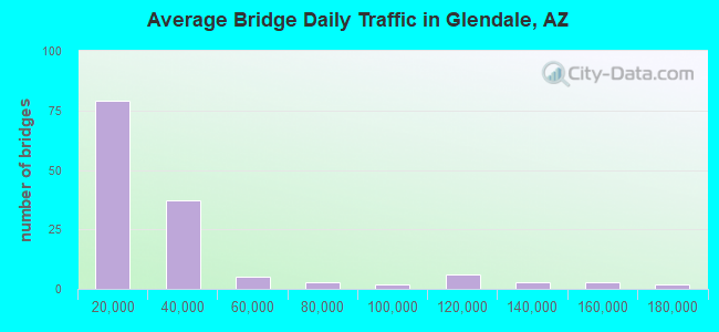
- 3,871,220Total average daily traffic
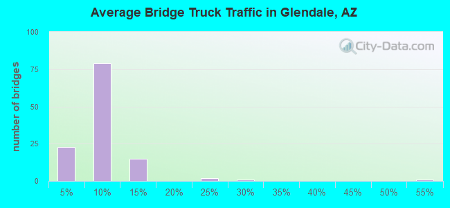
- 247,006Total average daily truck traffic
- National Bridge Inventory (NBI) Registered Bridges for Glendale
- No street view available for this location
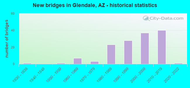
- New bridges - historical statistics
- 11930-1939
- 11950-1959
- 71960-1969
- 31970-1979
- 231980-1989
- 281990-1999
- 372000-2009
- 402010-2019
- 12020-2022
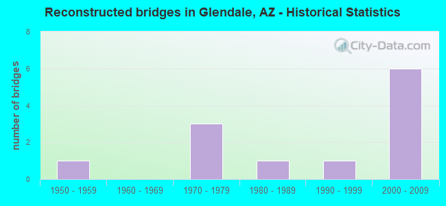
- Reconstructed bridges - Historical Statistics
- 11950-1959
- 01960-1969
- 31970-1979
- 11980-1989
- 11990-1999
- 62000-2009
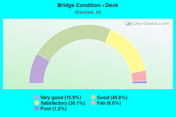
- Bridge Condition - Deck
- 16.9%Very good
- 45.8%Good
- 30.1%Satisfactory
- 6.0%Fair
- 1.2%Poor
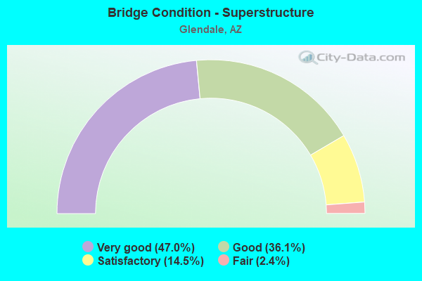
- Bridge Condition - Superstructure
- 47.0%Very good
- 36.1%Good
- 14.5%Satisfactory
- 2.4%Fair
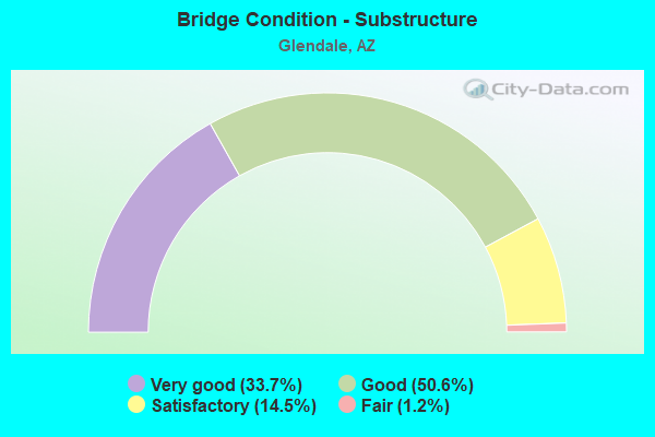
- Bridge Condition - Substructure
- 33.7%Very good
- 50.6%Good
- 14.5%Satisfactory
- 1.2%Fair
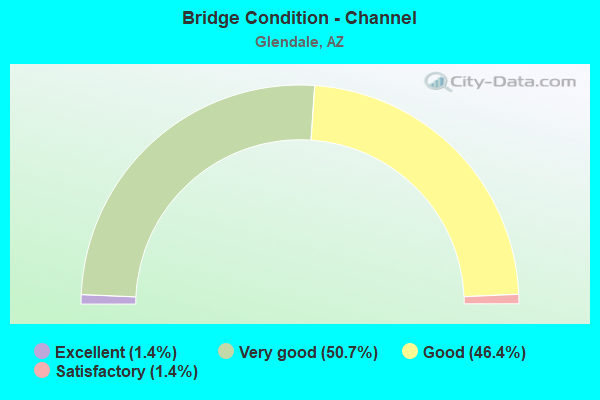
- Bridge Condition - Channel
- 1.4%Excellent
- 50.7%Very good
- 46.4%Good
- 1.4%Satisfactory
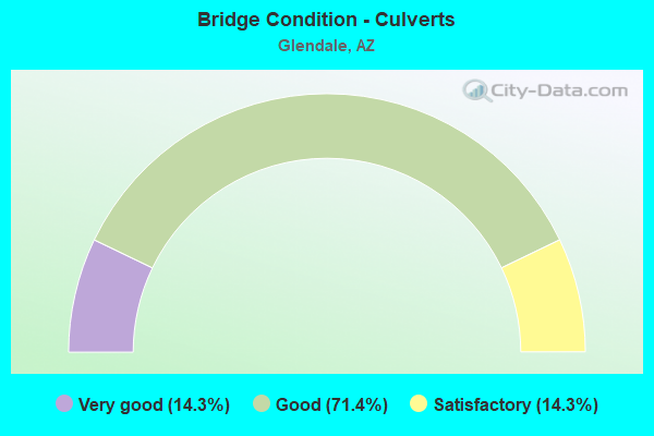
- Bridge Condition - Culverts
- 14.3%Very good
- 71.4%Good
- 14.3%Satisfactory
Find on map >> Show street view
Structure Number: 8831, Location: 200' E jct 58th Ave (Lat: 33.679900, Lng: -112.184900), Route carried "on" structure: City street , Year Built: 1985, Status: Open, Structure Length: 1.55m (5.09ft), Average Daily Traffic: 250 (year 2020), Truck Traffic: 1%, Average Future Daily Traffic: 260 (year 2040), Design Load: HS 20, Features Intersected: Lake, Facility Carried by Structure: Arrowhead Lakes Dr
Minimum Vertical Clearance: 30+ m (98+ ft), Kilometerpoint: 0.000, Lanes on structure: 2, Owner: City or Municipal Highway Agency, Approaching Roadway Width: 12.2m (40.0ft), Material/Design: Prestressed concrete, Design/Construction: Box Beam or Girders - Multiple, Number Of Spans In Main Unit: 1, Length of Maximum Span: 14.3m (46.9ft), Curb or Sidewalk Widths: Left: 1.6m (5.2ft), Right: 1.6m (5.2ft), Curb-To-Curb Width: 13.0m (42.7ft), Out-to-Out Width: 17.1m (56.1ft)
Condition: Deck: Good, Superstructure: Very good, Substructure: Satisfactory, Channel: Very good, Operating Rating: 84.4 metric tons, Method Used To Determine Operating Rating: Load Factor (LF), Inventory Rating: 49.9 metric tons, Method Used To Determine Inventory Rating: Load Factor (LF), Structural Evaluation: Equal to present minimum criteria, Deck Geometry: Superior to present desirable criteria, Waterway Adequacy: Equal to present desirable criteria, Approach Roadway Alignment: Equal to present desirable criteria, Designated Inspection Frequency: Every 24 months, Inspection Date: April 2020, Deck Structure Type: Concrete Cast-file-Place, Wearing Surface/Protective System: Wearing Surface: Bituminous
Find on map >> Show street view
Structure Number: 8832, Location: 200' S of Tonopah Dr (Lat: 33.670028, Lng: -112.176639), Route carried "on" structure: City street , Year Built: 1985, Status: Open, Structure Length: 0.85m (2.79ft), Average Daily Traffic: 250 (year 2020), Truck Traffic: 1%, Average Future Daily Traffic: 260 (year 2040), Design Load: HS 20, Features Intersected: Lake, Facility Carried by Structure: 54th Ave
Minimum Vertical Clearance: 30+ m (98+ ft), Kilometerpoint: 0.000, Lanes on structure: 2, Owner: City or Municipal Highway Agency, Approaching Roadway Width: 12.2m (40.0ft), Material/Design: Prestressed concrete, Design/Construction: Box Beam or Girders - Multiple, Number Of Spans In Main Unit: 1, Length of Maximum Span: 8.5m (27.9ft), Curb or Sidewalk Widths: Left: 1.6m (5.2ft), Right: 1.6m (5.2ft), Curb-To-Curb Width: 10.6m (34.8ft), Out-to-Out Width: 14.6m (47.9ft)
Condition: Deck: Good, Superstructure: Good, Substructure: Good, Channel: Very good, Operating Rating: 84.4 metric tons, Method Used To Determine Operating Rating: Load Factor (LF), Inventory Rating: 50.8 metric tons, Method Used To Determine Inventory Rating: Load Factor (LF), Structural Evaluation: Better than present minimum criteria, Deck Geometry: Better than present minimum criteria, Waterway Adequacy: Equal to present desirable criteria, Approach Roadway Alignment: Equal to present desirable criteria, Designated Inspection Frequency: Every 24 months, Inspection Date: April 2020, Deck Structure Type: Concrete Cast-file-Place, Wearing Surface/Protective System: Wearing Surface: Bituminous
Find on map >> Show street view
Structure Number: 8833, Location: 300' W jct 51st Ave (Lat: 33.671944, Lng: -112.170750), Route carried "on" structure: City street , Year Built: 1985, Status: Open, Structure Length: 1.55m (5.09ft), Average Daily Traffic: 350 (year 2020), Truck Traffic: 1%, Average Future Daily Traffic: 360 (year 2040), Design Load: HS 20, Features Intersected: Lake, Facility Carried by Structure: Tonapah Drive
Minimum Vertical Clearance: 30+ m (98+ ft), Kilometerpoint: 0.000, Lanes on structure: 2, Owner: City or Municipal Highway Agency, Approaching Roadway Width: 12.2m (40.0ft), Material/Design: Prestressed concrete, Design/Construction: Box Beam or Girders - Multiple, Number Of Spans In Main Unit: 1, Length of Maximum Span: 14.3m (46.9ft), Curb or Sidewalk Widths: Left: 1.6m (5.2ft), Right: 1.6m (5.2ft), Curb-To-Curb Width: 13.0m (42.7ft), Out-to-Out Width: 17.1m (56.1ft)
Condition: Deck: Good, Superstructure: Good, Substructure: Satisfactory, Channel: Very good, Operating Rating: 84.4 metric tons, Method Used To Determine Operating Rating: Load Factor (LF), Inventory Rating: 49.9 metric tons, Method Used To Determine Inventory Rating: Load Factor (LF), Structural Evaluation: Equal to present minimum criteria, Deck Geometry: Superior to present desirable criteria, Waterway Adequacy: Equal to present desirable criteria, Approach Roadway Alignment: Equal to present desirable criteria, Designated Inspection Frequency: Every 24 months, Inspection Date: April 2020, Deck Structure Type: Concrete Cast-file-Place, Wearing Surface/Protective System: Wearing Surface: Bituminous
Find on map >> Show street view
Structure Number: 8947, Location: 300' N Jct Union Hills Dr (Lat: 33.655300, Lng: -112.186300), Route carried "on" structure: City street , Year Built: 1985, Status: Open, Structure Length: 5.12m (16.80ft), Average Daily Traffic: 22,728 (year 2019), Truck Traffic: 5%, Average Future Daily Traffic: 22,738 (year 2039), Design Load: HS 20, Features Intersected: Skunk Creek, Facility Carried by Structure: 59th Ave
Minimum Vertical Clearance: 30+ m (98+ ft), Kilometerpoint: 0.000, Lanes on structure: 6, Owner: City or Municipal Highway Agency, Approaching Roadway Width: 21.9m (71.9ft), Skew: 20 degrees, Material/Design: Prestressed concrete continuous, Design/Construction: Slab, Number Of Spans In Main Unit: 3, Length of Maximum Span: 19.8m (65.0ft), Curb or Sidewalk Widths: Left: 1.6m (5.2ft), Right: 1.6m (5.2ft), Curb-To-Curb Width: 26.8m (87.9ft), Out-to-Out Width: 30.8m (101.0ft)
Condition: Deck: Satisfactory, Superstructure: Satisfactory, Substructure: Good, Channel: Good, Operating Rating: 89.8 metric tons, Method Used To Determine Operating Rating: Load Factor (LF), Inventory Rating: 59.9 metric tons, Method Used To Determine Inventory Rating: Load Factor (LF), Structural Evaluation: Equal to present minimum criteria, Deck Geometry: Better than present minimum criteria, Waterway Adequacy: Equal to present desirable criteria, Approach Roadway Alignment: Equal to present desirable criteria, Designated Inspection Frequency: Every 24 months, Inspection Date: May 2020, Deck Structure Type: Concrete Cast-file-Place, Wearing Surface/Protective System: Wearing Surface: Monolithic Concrete
Find on map >> Show street view
Structure Number: 8948, Location: 0.5 mi W Jct 59th Ave (Lat: 33.654300, Lng: -112.192200), Route carried "on" structure: City street , Year Built: 1987, Status: Open, Structure Length: 10.61m (34.81ft), Average Daily Traffic: 18,142 (year 2019), Truck Traffic: 5%, Average Future Daily Traffic: 18,152 (year 2039), Design Load: HS 20, Features Intersected: Skunk Creek, Facility Carried by Structure: Union Hills Dr
Minimum Vertical Clearance: 30+ m (98+ ft), Kilometerpoint: 0.000, Lanes on structure: 4, Owner: City or Municipal Highway Agency, Approaching Roadway Width: 19.5m (64.0ft), Skew: 26 degrees, Material/Design: Prestressed concrete continuous, Design/Construction: Box Beam or Girders - Multiple, Number Of Spans In Main Unit: 3, Length of Maximum Span: 34.1m (111.9ft), Curb or Sidewalk Widths: Left: 1.5m (4.9ft), Right: 1.5m (4.9ft), Curb-To-Curb Width: 28.0m (91.9ft), Out-to-Out Width: 32.6m (107.0ft)
Condition: Deck: Good, Superstructure: Good, Substructure: Good, Channel: Good, Operating Rating: 89.8 metric tons, Method Used To Determine Operating Rating: Load Factor (LF), Inventory Rating: 62.6 metric tons, Method Used To Determine Inventory Rating: Load Factor (LF), Structural Evaluation: Better than present minimum criteria, Deck Geometry: Superior to present desirable criteria, Waterway Adequacy: Equal to present desirable criteria, Approach Roadway Alignment: Equal to present desirable criteria, Designated Inspection Frequency: Every 24 months, Inspection Date: May 2020, Deck Structure Type: Concrete Cast-file-Place, Wearing Surface/Protective System: Wearing Surface: Monolithic Concrete
Find on map >> Show street view
Structure Number: 8949, Location: 0.15 mi N of Melinda Dr (Lat: 33.685858, Lng: -112.186639), Route carried "on" structure: City street , Year Built: 1985, Status: Open, Structure Length: 1.83m (6.00ft), Average Daily Traffic: 20,500 (year 2018), Truck Traffic: 5%, Average Future Daily Traffic: 20,510 (year 2038), Design Load: HS 20, Features Intersected: Wash, Facility Carried by Structure: 59th Ave
Minimum Vertical Clearance: 30+ m (98+ ft), Kilometerpoint: 0.000, Lanes on structure: 2, Owner: City or Municipal Highway Agency, Approaching Roadway Width: 17.7m (58.1ft), Skew: 24 degrees, Material/Design: Concrete continuous, Design/Construction: Culvert, Number Of Spans In Main Unit: 4, Length of Maximum Span: 3.0m (9.8ft), Curb or Sidewalk Widths: Left: 3.0m (9.8ft), Right: 0.0m
Condition: Channel: Good, Culverts: Good, Operating Rating: 59.9 metric tons, Method Used To Determine Operating Rating: Load Factor (LF), Inventory Rating: 36.3 metric tons, Method Used To Determine Inventory Rating: Load Factor (LF), Structural Evaluation: Better than present minimum criteria, Waterway Adequacy: Equal to present desirable criteria, Approach Roadway Alignment: Equal to present minimum criteria, Designated Inspection Frequency: Every 48 months, Inspection Date: April 2020
Find on map >> Show street view
Structure Number: 9124, Location: 0.1 mi E Jct 75th Ave (Lat: 33.638300, Lng: -112.213700), Route carried "on" structure: City street , Year Built: 1964, Year Reconstructed: 1977, Status: Open, Structure Length: 8.96m (29.40ft), Average Daily Traffic: 38,132 (year 2019), Truck Traffic: 5%, Average Future Daily Traffic: 38,142 (year 2039), Design Load: HS 20, Features Intersected: Skunk Creek, Facility Carried by Structure: Bell Road
Minimum Vertical Clearance: 30+ m (98+ ft), Kilometerpoint: 0.000, Lanes on structure: 6, Owner: City or Municipal Highway Agency, Approaching Roadway Width: 23.2m (76.1ft), Skew: 34 degrees, Material/Design: Concrete continuous, Design/Construction: Slab, Number Of Spans In Main Unit: 9, Length of Maximum Span: 10.4m (34.1ft), Curb-To-Curb Width: 22.6m (74.1ft), Out-to-Out Width: 23.5m (77.1ft)
Condition: Deck: Fair, Superstructure: Fair, Substructure: Satisfactory, Channel: Good, Operating Rating: 49.9 metric tons, Method Used To Determine Operating Rating: Load Factor (LF), Inventory Rating: 29.9 metric tons, Method Used To Determine Inventory Rating: Load Factor (LF), Structural Evaluation: Somewhat better than minimum adequacy, Deck Geometry: Meets minimum limits, Waterway Adequacy: Equal to present desirable criteria, Approach Roadway Alignment: Equal to present desirable criteria, Length Of Structure Improvement: 9.97m (32.71ft), Designated Inspection Frequency: Every 24 months, Inspection Date: May 2020, Bridge Improvement Cost: $2,000, Total Project Cost: $3,000 ( Estimate for 2020), Deck Structure Type: Concrete Cast-file-Place, Wearing Surface/Protective System: Wearing Surface: Monolithic Concrete
Find on map >> Show street view
Structure Number: 9141, Location: 1/2 mi W 99th Ave (Lat: 33.536750, Lng: -112.282194), Route carried "on" structure: City street , Year Built: 1960, Year Reconstructed: 2006, Status: Open, Structure Length: 10.91m (35.79ft), Average Daily Traffic: 21,194 (year 2019), Truck Traffic: 5%, Average Future Daily Traffic: 21,204 (year 2039), Design Load: HS 20, Features Intersected: New River, Facility Carried by Structure: Glendale Avenue
Minimum Vertical Clearance: 30+ m (98+ ft), Kilometerpoint: 0.000, Lanes on structure: 4, Owner: City or Municipal Highway Agency, Approaching Roadway Width: 15.8m (51.8ft), Material/Design: Steel continuous, Design/Construction: Stringer/Multi-beam, Number Of Spans In Main Unit: 7, Length of Maximum Span: 16.5m (54.1ft), Curb or Sidewalk Widths: Left: 1.8m (5.9ft), Right: 1.8m (5.9ft), Curb-To-Curb Width: 16.1m (52.8ft), Out-to-Out Width: 21.2m (69.6ft)
Condition: Deck: Satisfactory, Superstructure: Good, Substructure: Satisfactory, Channel: Very good, Operating Rating: 36.3 metric tons, Method Used To Determine Operating Rating: Load Factor (LF), Inventory Rating: 21.8 metric tons, Method Used To Determine Inventory Rating: Load Factor (LF), Structural Evaluation: Somewhat better than minimum adequacy, Deck Geometry: Meets minimum limits, Waterway Adequacy: Equal to present desirable criteria, Approach Roadway Alignment: Equal to present desirable criteria, Length Of Structure Improvement: 11.98m (39.30ft), Designated Inspection Frequency: Every 24 months, Inspection Date: July 2020, Bridge Improvement Cost: $1,000, Total Project Cost: $3,000 ( Estimate for 2020), Deck Structure Type: Concrete Cast-file-Place, Wearing Surface/Protective System: Wearing Surface: Monolithic Concrete
Find on map >> Show street view
Structure Number: 9301, Location: 0.2 mi E Jct El Mirage Rd (Lat: 33.536500, Lng: -112.320400), Route carried "on" structure: City street , Year Built: 1973, Status: Open, Structure Length: 18.38m (60.30ft), Average Daily Traffic: 20,306 (year 2019), Truck Traffic: 10%, Average Future Daily Traffic: 20,316 (year 2039), Design Load: HS 20, Features Intersected: Agua Fria River, Facility Carried by Structure: Glendale Avenue
Minimum Vertical Clearance: 30+ m (98+ ft), Kilometerpoint: 0.000, Lanes on structure: 4, Lanes under structure: 4, Owner: City or Municipal Highway Agency, Approaching Roadway Width: 22.6m (74.1ft), Material/Design: Prestressed concrete continuous, Design/Construction: Stringer/Multi-beam, Number Of Spans In Main Unit: 6, Length of Maximum Span: 30.5m (100.1ft), Curb-To-Curb Width: 22.6m (74.1ft), Out-to-Out Width: 23.3m (76.4ft)
Condition: Deck: Fair, Superstructure: Good, Substructure: Satisfactory, Channel: Good, Operating Rating: 70.8 metric tons, Method Used To Determine Operating Rating: Load Factor (LF), Inventory Rating: 32.7 metric tons, Method Used To Determine Inventory Rating: Load Factor (LF), Structural Evaluation: Equal to present minimum criteria, Deck Geometry: Superior to present desirable criteria, Underclear: High priority of corrective action, Waterway Adequacy: Better than present minimum criteria, Approach Roadway Alignment: Equal to present desirable criteria, Designated Inspection Frequency: Every 24 months, Inspection Date: May 2020, Deck Structure Type: Concrete Cast-file-Place, Wearing Surface/Protective System: Wearing Surface: Monolithic Concrete
Find on map >> Show street view
Structure Number: 9441, Location: 0.5 mi N Thunderbird (Lat: 33.618361, Lng: -112.202556), Route carried "on" structure: City street , Year Built: 1965, Year Reconstructed: 1988, Status: Open, Structure Length: 1.86m (6.10ft), Average Daily Traffic: 22,321 (year 2019), Truck Traffic: 5%, Average Future Daily Traffic: 22,331 (year 2039), Design Load: HS 20, Features Intersected: Arizona Canal, Facility Carried by Structure: 67th Avenue
Minimum Vertical Clearance: 30+ m (98+ ft), Kilometerpoint: 0.000, Lanes on structure: 5, Owner: City or Municipal Highway Agency, Approaching Roadway Width: 23.5m (77.1ft), Skew: 3 degrees, Material/Design: Concrete continuous, Design/Construction: Slab, Number Of Spans In Main Unit: 2, Length of Maximum Span: 9.1m (29.9ft), Curb or Sidewalk Widths: Left: 1.6m (5.2ft), Right: 2.9m (9.5ft), Curb-To-Curb Width: 23.5m (77.1ft), Out-to-Out Width: 27.3m (89.6ft)
Condition: Deck: Satisfactory, Superstructure: Satisfactory, Substructure: Good, Channel: Very good, Operating Rating: 49.0 metric tons, Method Used To Determine Operating Rating: Load Factor (LF), Inventory Rating: 29.0 metric tons, Method Used To Determine Inventory Rating: Load Factor (LF), Structural Evaluation: Equal to present minimum criteria, Deck Geometry: Better than present minimum criteria, Waterway Adequacy: Equal to present desirable criteria, Approach Roadway Alignment: Equal to present desirable criteria, Designated Inspection Frequency: Every 24 months, Underwater Inspection Frequency: Every 60 months, Inspection Date: January 2020, Underwater Inspection Date: December 2019, Deck Structure Type: Concrete Cast-file-Place, Wearing Surface/Protective System: Wearing Surface: Monolithic Concrete
Find on map >> Show street view
Structure Number: 9443, Location: at Bethany Home Road (Lat: 33.523300, Lng: -112.237700), Route carried "on" structure: City street , Year Built: 1974, Status: Open, Structure Length: 0.73m (2.40ft), Average Daily Traffic: 20,285 (year 2019), Truck Traffic: 5%, Average Future Daily Traffic: 20,295 (year 2039), Design Load: HS 20, Features Intersected: Grand Canal, Facility Carried by Structure: 83rd Avenue
Minimum Vertical Clearance: 13.72m (45.01ft), Kilometerpoint: 0.000, Lanes on structure: 6, Owner: City or Municipal Highway Agency, Approaching Roadway Width: 20.7m (67.9ft), Material/Design: Concrete, Design/Construction: Frame, Number Of Spans In Main Unit: 1, Length of Maximum Span: 6.7m (22.0ft), Curb or Sidewalk Widths: Left: 1.5m (4.9ft), Right: 2.4m (7.9ft), Curb-To-Curb Width: 31.5m (103.3ft), Out-to-Out Width: 36.5m (119.8ft)
Condition: Deck: Fair, Superstructure: Satisfactory, Substructure: Good, Channel: Good, Operating Rating: 48.1 metric tons, Method Used To Determine Operating Rating: Load Factor (LF), Inventory Rating: 29.0 metric tons, Method Used To Determine Inventory Rating: Load Factor (LF), Structural Evaluation: Equal to present minimum criteria, Deck Geometry: Superior to present desirable criteria, Waterway Adequacy: Equal to present desirable criteria, Approach Roadway Alignment: Equal to present desirable criteria, Designated Inspection Frequency: Every 24 months, Inspection Date: January 2022, Deck Structure Type: Concrete Cast-file-Place, Wearing Surface/Protective System: Wearing Surface: Monolithic Concrete
Find on map >> Show street view
Structure Number: 95, Location: 0.11 mi W of 51st Ave (Lat: 33.596361, Lng: -112.170500), Route carried "on" structure: City street , Year Built: 1968, Year Reconstructed: 1983, Status: Open, Structure Length: 1.86m (6.10ft), Average Daily Traffic: 31,880 (year 2019), Truck Traffic: 5%, Average Future Daily Traffic: 31,890 (year 2039), Design Load: HS 20, Features Intersected: Arizona Canal, Facility Carried by Structure: Cactus Road
Minimum Vertical Clearance: 30+ m (98+ ft), Kilometerpoint: 0.000, Lanes on structure: 6, Owner: City or Municipal Highway Agency, Approaching Roadway Width: 20.7m (67.9ft), Skew: 3 degrees, Material/Design: Concrete continuous, Design/Construction: Slab, Number Of Spans In Main Unit: 2, Length of Maximum Span: 9.1m (29.9ft), Curb or Sidewalk Widths: Left: 1.5m (4.9ft), Right: 1.5m (4.9ft), Curb-To-Curb Width: 20.7m (67.9ft), Out-to-Out Width: 24.4m (80.1ft)
Condition: Deck: Satisfactory, Superstructure: Satisfactory, Substructure: Very good, Channel: Good, Operating Rating: 36.3 metric tons, Method Used To Determine Operating Rating: Load Factor (LF), Inventory Rating: 21.8 metric tons, Method Used To Determine Inventory Rating: Load Factor (LF), Structural Evaluation: Somewhat better than minimum adequacy, Deck Geometry: High priority of replacement, Waterway Adequacy: Equal to present desirable criteria, Approach Roadway Alignment: Equal to present desirable criteria, Length Of Structure Improvement: 2.62m (8.60ft), Designated Inspection Frequency: Every 24 months, Inspection Date: January 2022, Total Project Cost: $2,000 ( Estimate for 2020), Deck Structure Type: Concrete Cast-file-Place, Wearing Surface/Protective System: Wearing Surface: Monolithic Concrete
Find on map >> Show street view
Structure Number: 9501, Location: Camelback at 75th Avenue (Lat: 33.509400, Lng: -112.220600), Route carried "on" structure: City street , Year Built: 1950, Status: Open, Structure Length: 1.25m (4.10ft), Average Daily Traffic: 26,400 (year 2015), Truck Traffic: 5%, Average Future Daily Traffic: 26,410 (year 2036), Design Load: HS 20, Features Intersected: Grand Canal, Facility Carried by Structure: Camelback Road
Minimum Vertical Clearance: 7.62m (25.00ft), Kilometerpoint: 0.000, Lanes on structure: 5, Owner: City or Municipal Highway Agency, Approaching Roadway Width: 19.8m (65.0ft), Skew: 4 degrees, Material/Design: Concrete continuous, Design/Construction: Culvert, Number Of Spans In Main Unit: 2, Length of Maximum Span: 4.6m (15.1ft), Curb or Sidewalk Widths: Left: 0.0m, Right: 2.1m (6.9ft)
Condition: Channel: Very good, Culverts: Good, Operating Rating: 62.6 metric tons, Method Used To Determine Operating Rating: Load Factor (LF), Inventory Rating: 37.2 metric tons, Method Used To Determine Inventory Rating: Load Factor (LF), Structural Evaluation: Better than present minimum criteria, Waterway Adequacy: Equal to present desirable criteria, Approach Roadway Alignment: Equal to present desirable criteria, Length Of Structure Improvement: 2.01m (6.59ft), Designated Inspection Frequency: Every 48 months, Inspection Date: April 2020, Total Project Cost: $1,000 ( Estimate for 2020)
Find on map >> Show street view
Structure Number: 9671, Location: 1 mi S Glendale Ave (Lat: 33.522861, Lng: -112.272389), Route carried "on" structure: City street , Year Built: 1980, Year Reconstructed: 1984, Status: Open, Structure Length: 1.10m (3.61ft), Average Daily Traffic: 9,619 (year 2019), Truck Traffic: 5%, Average Future Daily Traffic: 9,629 (year 2039), Design Load: HS 20, Features Intersected: Grand Canal, Facility Carried by Structure: 99th Avenue
Minimum Vertical Clearance: 30+ m (98+ ft), Kilometerpoint: 0.000, Lanes on structure: 5, Owner: City or Municipal Highway Agency, Approaching Roadway Width: 20.7m (67.9ft), Material/Design: Prestressed concrete, Design/Construction: Box Beam or Girders - Multiple, Number Of Spans In Main Unit: 1, Length of Maximum Span: 10.4m (34.1ft), Curb or Sidewalk Widths: Left: 0.0m, Right: 1.7m (5.6ft), Curb-To-Curb Width: 23.9m (78.4ft), Out-to-Out Width: 26.8m (87.9ft)
Condition: Deck: Satisfactory, Superstructure: Satisfactory, Substructure: Very good, Channel: Good, Operating Rating: 59.9 metric tons, Method Used To Determine Operating Rating: Load Factor (LF), Inventory Rating: 35.4 metric tons, Method Used To Determine Inventory Rating: Load Factor (LF), Structural Evaluation: Equal to present minimum criteria, Deck Geometry: Better than present minimum criteria, Waterway Adequacy: Equal to present desirable criteria, Approach Roadway Alignment: Equal to present desirable criteria, Designated Inspection Frequency: Every 24 months, Inspection Date: January 2022, Deck Structure Type: Concrete Precast Panels, Wearing Surface/Protective System: Wearing Surface: Bituminous
Find on map >> Show street view
Structure Number: 9685, Location: N. of Bethany Home Rd (Lat: 33.523300, Lng: -112.255100), Route carried "on" structure: City street , Year Built: 1981, Year Reconstructed: 2006, Status: Open, Structure Length: 1.01m (3.31ft), Average Daily Traffic: 9,765 (year 2019), Truck Traffic: 10%, Average Future Daily Traffic: 9,775 (year 2039), Design Load: HS 20, Features Intersected: Grand Canal, Facility Carried by Structure: 91st Ave
Minimum Vertical Clearance: 30+ m (98+ ft), Kilometerpoint: 0.000, Lanes on structure: 6, Owner: City or Municipal Highway Agency, Approaching Roadway Width: 29.3m (96.1ft), Material/Design: Prestressed concrete, Design/Construction: Box Beam or Girders - Multiple, Number Of Spans In Main Unit: 1, Length of Maximum Span: 9.8m (32.2ft), Curb or Sidewalk Widths: Left: 2.1m (6.9ft), Right: 1.5m (4.9ft), Curb-To-Curb Width: 29.3m (96.1ft), Out-to-Out Width: 34.1m (111.9ft)
Condition: Deck: Satisfactory, Superstructure: Good, Substructure: Good, Channel: Satisfactory, Operating Rating: 62.6 metric tons, Method Used To Determine Operating Rating: Load Factor (LF), Inventory Rating: 37.2 metric tons, Method Used To Determine Inventory Rating: Load Factor (LF), Structural Evaluation: Better than present minimum criteria, Deck Geometry: Superior to present desirable criteria, Waterway Adequacy: Equal to present desirable criteria, Approach Roadway Alignment: Equal to present desirable criteria, Designated Inspection Frequency: Every 24 months, Inspection Date: January 2022, Deck Structure Type: Concrete Cast-file-Place, Wearing Surface/Protective System: Wearing Surface: Bituminous
Find on map >> Show street view
Structure Number: 9764, Location: 0.6 mi N Jct Glendale Ave (Lat: 33.545400, Lng: -112.358600), Route carried "on" structure: City street , Year Built: 1982, Status: Open, Structure Length: 2.47m (8.10ft), Average Daily Traffic: 12,713 (year 2019), Truck Traffic: 10%, Average Future Daily Traffic: 12,723 (year 2039), Design Load: HS 20, Features Intersected: Dysart Drain, Facility Carried by Structure: Litchfield Road
Minimum Vertical Clearance: 30+ m (98+ ft), Kilometerpoint: 0.000, Lanes on structure: 5, Owner: City or Municipal Highway Agency, Approaching Roadway Width: 19.5m (64.0ft), Skew: 5 degrees, Material/Design: Concrete continuous, Design/Construction: Slab, Number Of Spans In Main Unit: 2, Length of Maximum Span: 11.9m (39.0ft), Curb or Sidewalk Widths: Left: 0.0m, Right: 1.4m (4.6ft), Curb-To-Curb Width: 20.7m (67.9ft), Out-to-Out Width: 23.4m (76.8ft)
Condition: Deck: Satisfactory, Superstructure: Satisfactory, Substructure: Good, Channel: Very good, Operating Rating: 89.8 metric tons, Method Used To Determine Operating Rating: Load Factor (LF), Inventory Rating: 75.3 metric tons, Method Used To Determine Inventory Rating: Load Factor (LF), Structural Evaluation: Equal to present minimum criteria, Deck Geometry: Somewhat better than minimum adequacy, Waterway Adequacy: Better than present minimum criteria, Approach Roadway Alignment: Equal to present desirable criteria, Designated Inspection Frequency: Every 24 months, Inspection Date: May 2020, Deck Structure Type: Concrete Cast-file-Place, Wearing Surface/Protective System: Wearing Surface: Monolithic Concrete
Find on map >> Show street view
Structure Number: 9793, Location: 0.15 mi West of 59th Ave (Lat: 33.610722, Lng: -112.190167), Route carried "on" structure: City street , Year Built: 1983, Status: Open, Structure Length: 1.71m (5.61ft), Average Daily Traffic: 28,315 (year 2019), Truck Traffic: 5%, Average Future Daily Traffic: 28,325 (year 2039), Design Load: HS 20, Features Intersected: Arizona Canal, Facility Carried by Structure: Thunderbird Road
Minimum Vertical Clearance: 30+ m (98+ ft), Kilometerpoint: 0.000, Lanes on structure: 6, Owner: City or Municipal Highway Agency, Approaching Roadway Width: 20.7m (67.9ft), Skew: 3 degrees, Material/Design: Concrete continuous, Design/Construction: Slab, Number Of Spans In Main Unit: 2, Length of Maximum Span: 8.5m (27.9ft), Curb or Sidewalk Widths: Left: 1.8m (5.9ft), Right: 1.8m (5.9ft), Curb-To-Curb Width: 20.7m (67.9ft), Out-to-Out Width: 24.9m (81.7ft)
Condition: Deck: Satisfactory, Superstructure: Satisfactory, Substructure: Very good, Channel: Very good, Operating Rating: 62.6 metric tons, Method Used To Determine Operating Rating: Load Factor (LF), Inventory Rating: 37.2 metric tons, Method Used To Determine Inventory Rating: Load Factor (LF), Structural Evaluation: Equal to present minimum criteria, Deck Geometry: High priority of replacement, Waterway Adequacy: Equal to present desirable criteria, Approach Roadway Alignment: Equal to present desirable criteria, Length Of Structure Improvement: 2.38m (7.81ft), Designated Inspection Frequency: Every 24 months, Inspection Date: January 2022, Total Project Cost: $1,000 ( Estimate for 2020), Deck Structure Type: Concrete Cast-file-Place, Wearing Surface/Protective System: Wearing Surface: Monolithic Concrete
Find on map >> Show street view
Structure Number: 9794, Location: 0.19 mi S Thunderbird Rd (Lat: 33.605806, Lng: -112.185917), Route carried "on" structure: City street , Year Built: 1983, Status: Open, Structure Length: 2.04m (6.69ft), Average Daily Traffic: 19,136 (year 2019), Truck Traffic: 5%, Average Future Daily Traffic: 19,146 (year 2039), Design Load: HS 20, Features Intersected: Arizona Canal, Facility Carried by Structure: 59th Avenue
Minimum Vertical Clearance: 12.19m (39.99ft), Kilometerpoint: 0.000, Lanes on structure: 6, Owner: City or Municipal Highway Agency, Approaching Roadway Width: 20.7m (67.9ft), Skew: 3 degrees, Material/Design: Concrete continuous, Design/Construction: Slab, Number Of Spans In Main Unit: 2, Length of Maximum Span: 9.8m (32.2ft), Curb or Sidewalk Widths: Left: 1.8m (5.9ft), Right: 1.8m (5.9ft), Curb-To-Curb Width: 20.7m (67.9ft), Out-to-Out Width: 24.8m (81.4ft)
Condition: Deck: Satisfactory, Superstructure: Satisfactory, Substructure: Very good, Channel: Very good, Operating Rating: 70.8 metric tons, Method Used To Determine Operating Rating: Load Factor (LF), Inventory Rating: 41.7 metric tons, Method Used To Determine Inventory Rating: Load Factor (LF), Structural Evaluation: Equal to present minimum criteria, Deck Geometry: High priority of replacement, Waterway Adequacy: Equal to present desirable criteria, Approach Roadway Alignment: Equal to present desirable criteria, Designated Inspection Frequency: Every 24 months, Inspection Date: January 2022, Deck Structure Type: Concrete Cast-file-Place, Wearing Surface/Protective System: Wearing Surface: Monolithic Concrete
Find on map >> Show street view
Structure Number: 9876, Location: 0.3 mi N Jct Bell Rd (Lat: 33.643500, Lng: -112.203000), Route carried "on" structure: City street , Year Built: 1996, Status: Open, Structure Length: 5.21m (17.09ft), Average Daily Traffic: 24,723 (year 2019), Truck Traffic: 5%, Average Future Daily Traffic: 24,733 (year 2039), Design Load: HS 20, Features Intersected: Wash (Flood Relief), Facility Carried by Structure: 67th Ave
Minimum Vertical Clearance: 30+ m (98+ ft), Kilometerpoint: 0.000, Lanes on structure: 5, Owner: City or Municipal Highway Agency, Approaching Roadway Width: 24.7m (81.0ft), Skew: 3 degrees, Material/Design: Prestressed concrete continuous, Design/Construction: Box Beam or Girders - Multiple, Number Of Spans In Main Unit: 3, Length of Maximum Span: 16.8m (55.1ft), Curb or Sidewalk Widths: Left: 1.6m (5.2ft), Right: 1.6m (5.2ft), Curb-To-Curb Width: 24.7m (81.0ft), Out-to-Out Width: 29.3m (96.1ft)
Condition: Deck: Good, Superstructure: Good, Substructure: Good, Channel: Very good, Operating Rating: 61.7 metric tons, Method Used To Determine Operating Rating: Load Factor (LF), Inventory Rating: 36.3 metric tons, Method Used To Determine Inventory Rating: Load Factor (LF), Structural Evaluation: Better than present minimum criteria, Deck Geometry: Superior to present desirable criteria, Waterway Adequacy: Equal to present desirable criteria, Approach Roadway Alignment: Equal to present desirable criteria, Designated Inspection Frequency: Every 24 months, Inspection Date: May 2020, Deck Structure Type: Concrete Precast Panels, Wearing Surface/Protective System: Wearing Surface: Monolithic Concrete
Find on map >> Show street view
Structure Number: 9883, Location: 0.2 mi S Jct Greenway Rd (Lat: 33.621000, Lng: -112.202500), Route carried "on" structure: City street , Year Built: 1985, Status: Open, Structure Length: 16.95m (55.61ft), Average Daily Traffic: 24,723 (year 2019), Truck Traffic: 5%, Average Future Daily Traffic: 24,733 (year 2039), Design Load: HS 20, Features Intersected: Az Cnl Diversion Channel, Facility Carried by Structure: 67th Avenue
Minimum Vertical Clearance: 30+ m (98+ ft), Kilometerpoint: 0.000, Lanes on structure: 4, Owner: City or Municipal Highway Agency, Approaching Roadway Width: 20.7m (67.9ft), Skew: 3 degrees, Material/Design: Prestressed concrete continuous, Design/Construction: Stringer/Multi-beam, Number Of Spans In Main Unit: 6, Length of Maximum Span: 28.0m (91.9ft), Curb or Sidewalk Widths: Left: 1.5m (4.9ft), Right: 1.5m (4.9ft), Curb-To-Curb Width: 20.7m (67.9ft), Out-to-Out Width: 25.1m (82.3ft)
Condition: Deck: Fair, Superstructure: Good, Substructure: Satisfactory, Channel: Very good, Operating Rating: 72.6 metric tons, Method Used To Determine Operating Rating: Load Factor (LF), Inventory Rating: 33.6 metric tons, Method Used To Determine Inventory Rating: Load Factor (LF), Structural Evaluation: Equal to present minimum criteria, Deck Geometry: Superior to present desirable criteria, Waterway Adequacy: Equal to present desirable criteria, Approach Roadway Alignment: Equal to present desirable criteria, Designated Inspection Frequency: Every 24 months, Inspection Date: May 2020, Deck Structure Type: Concrete Precast Panels, Wearing Surface/Protective System: Wearing Surface: Integral Concrete
Find on map >> Show street view
Structure Number: 9885, Location: 0.2 mi S Jct Thndrbird Rd (Lat: 33.606189, Lng: -112.185908), Route carried "on" structure: City street , Year Built: 1984, Status: Open, Structure Length: 18.29m (60.01ft), Average Daily Traffic: 19,136 (year 2019), Truck Traffic: 5%, Average Future Daily Traffic: 19,146 (year 2039), Design Load: HS 20, Features Intersected: Az Cnl Diversion Channel, Facility Carried by Structure: 59th Avenue
Minimum Vertical Clearance: 9.14m (29.99ft), Kilometerpoint: 0.000, Lanes on structure: 5, Owner: City or Municipal Highway Agency, Approaching Roadway Width: 20.7m (67.9ft), Skew: 4 degrees, Material/Design: Prestressed concrete continuous, Design/Construction: Stringer/Multi-beam, Number Of Spans In Main Unit: 5, Length of Maximum Span: 36.3m (119.1ft), Curb or Sidewalk Widths: Left: 1.5m (4.9ft), Right: 1.5m (4.9ft), Curb-To-Curb Width: 20.7m (67.9ft), Out-to-Out Width: 25.1m (82.3ft)
Condition: Deck: Satisfactory, Superstructure: Good, Substructure: Satisfactory, Channel: Very good, Operating Rating: 89.8 metric tons, Method Used To Determine Operating Rating: Load Factor (LF), Inventory Rating: 32.7 metric tons, Method Used To Determine Inventory Rating: Load Factor (LF), Structural Evaluation: Equal to present minimum criteria, Deck Geometry: Somewhat better than minimum adequacy, Waterway Adequacy: Equal to present desirable criteria, Approach Roadway Alignment: Equal to present desirable criteria, Designated Inspection Frequency: Every 24 months, Inspection Date: May 2020, Deck Structure Type: Concrete Cast-file-Place, Wearing Surface/Protective System: Wearing Surface: Monolithic Concrete
Find on map >> Show street view
Structure Number: 9886, Location: 100 ft W Jct 51st Ave (Lat: 33.596300, Lng: -112.170000), Route carried "on" structure: City street , Year Built: 1986, Status: Open, Structure Length: 8.63m (28.31ft), Average Daily Traffic: 25,046 (year 2019), Truck Traffic: 5%, Average Future Daily Traffic: 25,056 (year 2039), Design Load: HS 20, Features Intersected: Az Cnl Diversion Channel, Facility Carried by Structure: Cactus Road
Minimum Vertical Clearance: 30+ m (98+ ft), Kilometerpoint: 0.000, Lanes on structure: 5, Owner: City or Municipal Highway Agency, Approaching Roadway Width: 20.7m (67.9ft), Skew: 25 degrees, Material/Design: Prestressed concrete continuous, Design/Construction: Box Beam or Girders - Single/Spread, Number Of Spans In Main Unit: 2, Length of Maximum Span: 42.7m (140.1ft), Curb or Sidewalk Widths: Left: 1.5m (4.9ft), Right: 1.5m (4.9ft), Curb-To-Curb Width: 20.7m (67.9ft), Out-to-Out Width: 25.3m (83.0ft)
Condition: Deck: Good, Superstructure: Good, Substructure: Very good, Channel: Good, Operating Rating: 89.8 metric tons, Method Used To Determine Operating Rating: Load Factor (LF), Inventory Rating: 47.2 metric tons, Method Used To Determine Inventory Rating: Load Factor (LF), Structural Evaluation: Better than present minimum criteria, Deck Geometry: Somewhat better than minimum adequacy, Waterway Adequacy: Equal to present desirable criteria, Approach Roadway Alignment: Equal to present desirable criteria, Designated Inspection Frequency: Every 24 months, Inspection Date: May 2020, Deck Structure Type: Concrete Cast-file-Place, Wearing Surface/Protective System: Wearing Surface: Monolithic Concrete
Find on map >> Show street view
Structure Number: 9887, Location: 0.1 mi W Jct 59th Ave (Lat: 33.610700, Lng: -112.189700), Route carried "on" structure: City street , Year Built: 1984, Status: Open, Structure Length: 15.03m (49.31ft), Average Daily Traffic: 28,315 (year 2019), Truck Traffic: 5%, Average Future Daily Traffic: 28,325 (year 2039), Design Load: HS 20, Features Intersected: AZ Cnl Diversion Channel, Facility Carried by Structure: Thunderbird Road
Minimum Vertical Clearance: 9.14m (29.99ft), Kilometerpoint: 0.000, Lanes on structure: 5, Owner: City or Municipal Highway Agency, Approaching Roadway Width: 20.7m (67.9ft), Skew: 3 degrees, Material/Design: Prestressed concrete continuous, Design/Construction: Stringer/Multi-beam, Number Of Spans In Main Unit: 4, Length of Maximum Span: 37.5m (123.0ft), Curb or Sidewalk Widths: Left: 1.5m (4.9ft), Right: 1.5m (4.9ft), Curb-To-Curb Width: 20.7m (67.9ft), Out-to-Out Width: 25.2m (82.7ft)
Condition: Deck: Satisfactory, Superstructure: Good, Substructure: Satisfactory, Channel: Good, Operating Rating: 70.8 metric tons, Method Used To Determine Operating Rating: Load Factor (LF), Inventory Rating: 32.7 metric tons, Method Used To Determine Inventory Rating: Load Factor (LF), Structural Evaluation: Equal to present minimum criteria, Deck Geometry: Somewhat better than minimum adequacy, Waterway Adequacy: Equal to present desirable criteria, Approach Roadway Alignment: Equal to present desirable criteria, Designated Inspection Frequency: Every 24 months, Inspection Date: May 2020, Deck Structure Type: Concrete Cast-file-Place, Wearing Surface/Protective System: Wearing Surface: Monolithic Concrete
Find on map >> Show street view
Structure Number: 9906, Location: 180' E Jct 83rd Ave (Lat: 33.652700, Lng: -112.237000), Route carried "on" structure: City street , Year Built: 1997, Year Reconstructed: 2006, Status: Open, Structure Length: 7.50m (24.61ft), Average Daily Traffic: 24,090 (year 2019), Truck Traffic: 5%, Average Future Daily Traffic: 24,100 (year 2039), Design Load: HS 20, Features Intersected: New River Bridge, Facility Carried by Structure: Union Hills drive
Minimum Vertical Clearance: 30+ m (98+ ft), Kilometerpoint: 0.000, Lanes on structure: 8, Owner: City or Municipal Highway Agency, Approaching Roadway Width: 31.7m (104.0ft), Skew: 1 degrees, Material/Design: Concrete continuous, Design/Construction: Slab, Number Of Spans In Main Unit: 5, Length of Maximum Span: 14.9m (48.9ft), Curb or Sidewalk Widths: Left: 1.8m (5.9ft), Right: 1.8m (5.9ft), Curb-To-Curb Width: 31.7m (104.0ft), Out-to-Out Width: 36.7m (120.4ft)
Condition: Deck: Satisfactory, Superstructure: Good, Substructure: Good, Channel: Very good, Operating Rating: 89.8 metric tons, Method Used To Determine Operating Rating: Load Factor (LF), Inventory Rating: 54.4 metric tons, Method Used To Determine Inventory Rating: Load Factor (LF), Structural Evaluation: Better than present minimum criteria, Deck Geometry: Somewhat better than minimum adequacy, Waterway Adequacy: Equal to present desirable criteria, Approach Roadway Alignment: Equal to present desirable criteria, Designated Inspection Frequency: Every 24 months, Inspection Date: May 2020, Deck Structure Type: Concrete Cast-file-Place, Wearing Surface/Protective System: Wearing Surface: Monolithic Concrete
Find on map >> Show street view
Structure Number: 9949, Location: 0.5 mi N/ Glendale Ave (Lat: 33.543611, Lng: -112.324133), Route carried "on" structure: County highway , Year Built: 1995, Status: Open, Structure Length: 2.29m (7.51ft), Average Daily Traffic: 7,704 (year 2019), Truck Traffic: 10%, Average Future Daily Traffic: 7,714 (year 2039), Design Load: HS 20, Features Intersected: Dysart Drain, Facility Carried by Structure: El Mirage Rd
Minimum Vertical Clearance: 30+ m (98+ ft), Kilometerpoint: 0.000, Lanes on structure: 2, Owner: County Highway Agency, Approaching Roadway Width: 8.5m (27.9ft), Material/Design: Prestressed concrete, Design/Construction: Stringer/Multi-beam, Number Of Spans In Main Unit: 1, Length of Maximum Span: 21.9m (71.9ft), Curb or Sidewalk Widths: Left: 1.8m (5.9ft), Right: 1.8m (5.9ft), Curb-To-Curb Width: 20.7m (67.9ft), Out-to-Out Width: 25.6m (84.0ft)
Condition: Deck: Satisfactory, Superstructure: Good, Substructure: Good, Channel: Good, Operating Rating: 74.3 metric tons, Method Used To Determine Operating Rating: Load Factor (LF), Inventory Rating: 33.8 metric tons, Method Used To Determine Inventory Rating: Load Factor (LF), Structural Evaluation: Better than present minimum criteria, Deck Geometry: Superior to present desirable criteria, Waterway Adequacy: Equal to present desirable criteria, Approach Roadway Alignment: Equal to present desirable criteria, Designated Inspection Frequency: Every 24 months, Inspection Date: October 2020, Deck Structure Type: Concrete Cast-file-Place, Wearing Surface/Protective System: Wearing Surface: Monolithic Concrete
Find on map >> Show street view
Structure Number: 9997, Location: 0.1 mi E of 57th Ave (Lat: 33.661694, Lng: -112.178139), Route carried "on" structure: City street , Year Built: 1992, Status: Open, Structure Length: 1.65m (5.41ft), Average Daily Traffic: 3,120 (year 2018), Truck Traffic: 1%, Average Future Daily Traffic: 3,130 (year 2038), Design Load: HS 20, Features Intersected: Wash, Facility Carried by Structure: Utopia Road
Minimum Vertical Clearance: 30+ m (98+ ft), Kilometerpoint: 0.000, Lanes on structure: 2, Owner: City or Municipal Highway Agency, Approaching Roadway Width: 12.2m (40.0ft), Material/Design: Concrete continuous, Design/Construction: Culvert, Number Of Spans In Main Unit: 5, Length of Maximum Span: 3.0m (9.8ft)
Condition: Channel: Good, Culverts: Good, Operating Rating: 62.6 metric tons, Method Used To Determine Operating Rating: Load Factor (LF), Inventory Rating: 37.2 metric tons, Method Used To Determine Inventory Rating: Load Factor (LF), Structural Evaluation: Better than present minimum criteria, Waterway Adequacy: Equal to present desirable criteria, Approach Roadway Alignment: Equal to present desirable criteria, Designated Inspection Frequency: Every 48 months, Inspection Date: April 2020
Find on map >> Show street view
Structure Number: 1, Location: 0.5 mi N Jct Glendale Ave (Lat: 33.543700, Lng: -112.341300), Route carried "on" structure: City street , Year Built: 1995, Status: Open, Structure Length: 2.29m (7.51ft), Average Daily Traffic: 12,500 (year 2015), Truck Traffic: 10%, Average Future Daily Traffic: 12,510 (year 2038), Design Load: HS 20, Features Intersected: Dysart Drain, Facility Carried by Structure: Dysart Rd
Minimum Vertical Clearance: 30+ m (98+ ft), Kilometerpoint: 0.000, Lanes on structure: 4, Owner: City or Municipal Highway Agency, Approaching Roadway Width: 20.7m (67.9ft), Material/Design: Prestressed concrete, Design/Construction: Stringer/Multi-beam, Number Of Spans In Main Unit: 1, Length of Maximum Span: 21.6m (70.9ft), Curb or Sidewalk Widths: Left: 1.8m (5.9ft), Right: 1.8m (5.9ft), Curb-To-Curb Width: 20.7m (67.9ft), Out-to-Out Width: 25.6m (84.0ft)
Condition: Deck: Satisfactory, Superstructure: Very good, Substructure: Good, Channel: Good, Operating Rating: 70.8 metric tons, Method Used To Determine Operating Rating: Load Factor (LF), Inventory Rating: 32.7 metric tons, Method Used To Determine Inventory Rating: Load Factor (LF), Structural Evaluation: Better than present minimum criteria, Deck Geometry: Superior to present desirable criteria, Waterway Adequacy: Equal to present desirable criteria, Approach Roadway Alignment: Equal to present desirable criteria, Designated Inspection Frequency: Every 24 months, Inspection Date: April 2020, Deck Structure Type: Concrete Cast-file-Place
Find on map >> Show street view
Structure Number: 10154, Location: 4.5 mi N of Jct I 10 (Lat: 33.523556, Lng: -112.272389), Route carried "on" structure: City street , Year Built: 1999, Status: Open, Structure Length: 2.87m (9.42ft), Average Daily Traffic: 8,900 (year 2018), Truck Traffic: 3%, Average Future Daily Traffic: 8,910 (year 2038), Design Load: HS 20, Features Intersected: Drain Channel, Facility Carried by Structure: 99 th. Ave.
Minimum Vertical Clearance: 30+ m (98+ ft), Kilometerpoint: 0.000, Lanes on structure: 5, Owner: City or Municipal Highway Agency, Approaching Roadway Width: 20.4m (66.9ft), Material/Design: Concrete continuous, Design/Construction: Slab, Number Of Spans In Main Unit: 3, Length of Maximum Span: 9.1m (29.9ft), Curb or Sidewalk Widths: Left: 1.6m (5.2ft), Right: 1.6m (5.2ft), Curb-To-Curb Width: 29.9m (98.1ft), Out-to-Out Width: 34.7m (113.8ft)
Condition: Deck: Good, Superstructure: Good, Substructure: Good, Channel: Very good, Operating Rating: 68.9 metric tons, Method Used To Determine Operating Rating: Load Factor (LF), Inventory Rating: 40.8 metric tons, Method Used To Determine Inventory Rating: Load Factor (LF), Structural Evaluation: Better than present minimum criteria, Deck Geometry: Superior to present desirable criteria, Waterway Adequacy: Equal to present desirable criteria, Approach Roadway Alignment: Equal to present desirable criteria, Designated Inspection Frequency: Every 24 months, Inspection Date: April 2020, Deck Structure Type: Concrete Cast-file-Place, Wearing Surface/Protective System: Wearing Surface: Monolithic Concrete
Find on map >> Show street view
Structure Number: 10155, Location: 0.99 mi N of Camelback Rd (Lat: 33.522667, Lng: -112.290028), Route carried "on" structure: City street , Year Built: 1999, Status: Open, Structure Length: 2.35m (7.71ft), Average Daily Traffic: 10 (year 2020), Average Future Daily Traffic: 20 (year 2040), Design Load: HS 20, Features Intersected: Outfall Channel Wash, Facility Carried by Structure: 107th Ave
Minimum Vertical Clearance: 30+ m (98+ ft), Kilometerpoint: 0.000, Lanes on structure: 2, Owner: City or Municipal Highway Agency, Approaching Roadway Width: 11.0m (36.1ft), Material/Design: Concrete continuous, Design/Construction: Slab, Number Of Spans In Main Unit: 3, Length of Maximum Span: 8.2m (26.9ft), Curb or Sidewalk Widths: Left: 1.5m (4.9ft), Right: 1.5m (4.9ft), Curb-To-Curb Width: 11.0m (36.1ft), Out-to-Out Width: 14.6m (47.9ft)
Condition: Deck: Good, Superstructure: Good, Substructure: Very good, Channel: Very good, Operating Rating: 89.8 metric tons, Method Used To Determine Operating Rating: Load Factor (LF), Inventory Rating: 65.3 metric tons, Method Used To Determine Inventory Rating: Load Factor (LF), Structural Evaluation: Better than present minimum criteria, Deck Geometry: Superior to present desirable criteria, Waterway Adequacy: Equal to present desirable criteria, Approach Roadway Alignment: Equal to present desirable criteria, Designated Inspection Frequency: Every 24 months, Inspection Date: April 2020, Deck Structure Type: Concrete Cast-file-Place, Wearing Surface/Protective System: Wearing Surface: Monolithic Concrete
Find on map >> Show street view
Structure Number: 10512, Location: 200' E of 125th Ave (Lat: 33.522089, Lng: -112.327458), Route carried "on" structure: County highway , Year Built: 2004, Year Reconstructed: 2009, Status: Open, Structure Length: 0.85m (2.79ft), Average Daily Traffic: 3,036 (year 2020), Truck Traffic: 2%, Average Future Daily Traffic: 3,046 (year 2040), Design Load: HS 20, Features Intersected: Wash, Facility Carried by Structure: Bethany Home Rd
Minimum Vertical Clearance: 30+ m (98+ ft), Kilometerpoint: 0.000, Lanes on structure: 3, Owner: County Highway Agency, Approaching Roadway Width: 12.2m (40.0ft), Skew: 2 degrees, Material/Design: Concrete continuous, Design/Construction: Culvert, Number Of Spans In Main Unit: 3, Length of Maximum Span: 2.7m (8.9ft), Curb or Sidewalk Widths: Left: 1.5m (4.9ft), Right: 1.5m (4.9ft), Curb-To-Curb Width: 17.1m (56.1ft), Out-to-Out Width: 20.1m (65.9ft)
Condition: Channel: Good, Culverts: Satisfactory, Operating Rating: 49.0 metric tons, Method Used To Determine Operating Rating: Load Factor (LF), Inventory Rating: 29.0 metric tons, Method Used To Determine Inventory Rating: Load Factor (LF), Structural Evaluation: Equal to present minimum criteria, Deck Geometry: Superior to present desirable criteria, Waterway Adequacy: Equal to present desirable criteria, Approach Roadway Alignment: Equal to present desirable criteria, Designated Inspection Frequency: Every 48 months, Inspection Date: November 2021, Wearing Surface/Protective System: Wearing Surface: Bituminous
Find on map >> Show street view
Structure Number: 10516, Location: 0.53 mi W/ Perryville Rd (Lat: 33.566142, Lng: -112.470703), Route carried "on" structure: County highway , Year Built: 2004, Status: Open, Structure Length: 0.64m (2.10ft), Average Daily Traffic: 1,292 (year 2019), Truck Traffic: 5%, Average Future Daily Traffic: 1,302 (year 2039), Design Load: HS 20, Features Intersected: Wash W/ Beardsley Canal, Facility Carried by Structure: Olive Avenue
Minimum Vertical Clearance: 30+ m (98+ ft), Kilometerpoint: 0.000, Lanes on structure: 2, Owner: County Highway Agency, Approaching Roadway Width: 8.5m (27.9ft), Material/Design: Concrete continuous, Design/Construction: Culvert, Number Of Spans In Main Unit: 2, Length of Maximum Span: 3.0m (9.8ft), Curb-To-Curb Width: 9.8m (32.2ft), Out-to-Out Width: 9.8m (32.2ft)
Condition: Channel: Good, Culverts: Good, Operating Rating: 53.8 metric tons, Method Used To Determine Operating Rating: Load Factor (LF), Inventory Rating: 32.2 metric tons, Method Used To Determine Inventory Rating: Load Factor (LF), Structural Evaluation: Better than present minimum criteria, Deck Geometry: Somewhat better than minimum adequacy, Waterway Adequacy: Equal to present desirable criteria, Approach Roadway Alignment: Equal to present desirable criteria, Designated Inspection Frequency: Every 48 months, Inspection Date: December 2020, Wearing Surface/Protective System: Wearing Surface: Bituminous
Find on map >> Show street view
Structure Number: 10604, Location: 300' E Jct 63rd Ave (Lat: 33.667800, Lng: -112.194100), Route carried "on" structure: City street , Year Built: 2011, Status: Open, Structure Length: 1.44m (4.72ft), Average Daily Traffic: 5,387 (year 2019), Truck Traffic: 1%, Average Future Daily Traffic: 5,397 (year 2039), Design Load: HS 20, Features Intersected: Multiuse Path, Facility Carried by Structure: Beardsley
Minimum Vertical Clearance: 30+ m (98+ ft), Kilometerpoint: 0.000, Lanes on structure: 2, Owner: City or Municipal Highway Agency, Approaching Roadway Width: 8.7m (28.5ft), Material/Design: Prestressed concrete, Design/Construction: Box Beam or Girders - Multiple, Number Of Spans In Main Unit: 1, Length of Maximum Span: 13.4m (44.0ft), Curb-To-Curb Width: 8.7m (28.5ft), Out-to-Out Width: 9.9m (32.5ft)
Condition: Deck: Very good, Superstructure: Very good, Substructure: Good, Operating Rating: 63.5 metric tons, Method Used To Determine Operating Rating: Load Factor (LF), Inventory Rating: 39.0 metric tons, Method Used To Determine Inventory Rating: Load Factor (LF), Structural Evaluation: Better than present minimum criteria, Deck Geometry: High priority of corrective action, Approach Roadway Alignment: Equal to present desirable criteria, Length Of Structure Improvement: 1.43m (4.69ft), Designated Inspection Frequency: Every 24 months, Inspection Date: May 2020, Bridge Improvement Cost: $1,000, Total Project Cost: $1,000 ( Estimate for 2020), Deck Structure Type: Concrete Cast-file-Place, Wearing Surface/Protective System: Wearing Surface: Integral Concrete
Find on map >> Show street view
Structure Number: 10779, Location: 0.48 mi W/ Perryville Rd (Lat: 33.566150, Lng: -112.469844), Route carried "on" structure: County highway , Year Built: 2007, Status: Open, Structure Length: 0.82m (2.69ft), Average Daily Traffic: 1,292 (year 2019), Truck Traffic: 5%, Average Future Daily Traffic: 1,302 (year 2039), Design Load: HS 20, Features Intersected: Waterfall Wash, Facility Carried by Structure: Olive Avenue
Minimum Vertical Clearance: 30+ m (98+ ft), Kilometerpoint: 0.000, Lanes on structure: 2, Owner: County Highway Agency, Approaching Roadway Width: 8.5m (27.9ft), Skew: 3 degrees, Material/Design: Concrete continuous, Design/Construction: Culvert, Number Of Spans In Main Unit: 2, Length of Maximum Span: 4.0m (13.1ft)
Condition: Channel: Good, Culverts: Good, Structural Evaluation: Better than present minimum criteria, Waterway Adequacy: Equal to present desirable criteria, Approach Roadway Alignment: Equal to present desirable criteria, Designated Inspection Frequency: Every 48 months, Inspection Date: December 2020
Find on map >> Show street view
Structure Number: 1078, Location: 0.53 mi W/ Perryville Rd (Lat: 33.551586, Lng: -112.470842), Route carried "on" structure: County highway , Year Built: 2007, Status: Open, Structure Length: 1.58m (5.18ft), Average Daily Traffic: 200 (year 2020), Average Future Daily Traffic: 210 (year 2040), Design Load: HS 20, Features Intersected: Beardsley Wash, Facility Carried by Structure: Northern Avenue
Minimum Vertical Clearance: 30+ m (98+ ft), Kilometerpoint: 0.000, Lanes on structure: 2, Owner: Private, Maintenance Responsibility: County Highway Agency, Approaching Roadway Width: 7.3m (24.0ft), Material/Design: Concrete continuous, Design/Construction: Culvert, Number Of Spans In Main Unit: 4, Length of Maximum Span: 3.7m (12.1ft)
Condition: Channel: Good, Culverts: Good, Structural Evaluation: Better than present minimum criteria, Waterway Adequacy: Equal to present desirable criteria, Approach Roadway Alignment: Equal to present desirable criteria, Designated Inspection Frequency: Every 48 months, Inspection Date: December 2020
Find on map >> Show street view
Structure Number: 10781, Location: 0.52 mi W/ Perryville Rd (Lat: 33.551600, Lng: -112.470525), Route carried "on" structure: County highway , Year Built: 2007, Status: Open, Structure Length: 1.22m (4.00ft), Average Daily Traffic: 200 (year 2020), Average Future Daily Traffic: 210 (year 2040), Design Load: HS 20, Features Intersected: FRS#3 Dvrsn Chnl, Facility Carried by Structure: Northern Avenue
Minimum Vertical Clearance: 30+ m (98+ ft), Kilometerpoint: 0.000, Lanes on structure: 2, Owner: Private, Maintenance Responsibility: County Highway Agency, Approaching Roadway Width: 7.3m (24.0ft), Skew: 3 degrees, Material/Design: Concrete continuous, Design/Construction: Culvert, Number Of Spans In Main Unit: 3, Length of Maximum Span: 4.0m (13.1ft)
Condition: Channel: Good, Culverts: Good, Structural Evaluation: Better than present minimum criteria, Waterway Adequacy: Equal to present desirable criteria, Approach Roadway Alignment: Equal to present desirable criteria, Designated Inspection Frequency: Every 48 months, Inspection Date: December 2020
Find on map >> Show street view
Structure Number: 10829, Location: 100' N Jct Bethany Hm Rd (Lat: 33.522700, Lng: -112.237600), Route carried "on" structure: City street , Year Built: 2002, Status: Open, Structure Length: 4.57m (14.99ft), Average Daily Traffic: 20,285 (year 2019), Truck Traffic: 5%, Average Future Daily Traffic: 20,295 (year 2039), Design Load: HS 20, Features Intersected: Bethany Home Outfall Chn, Facility Carried by Structure: 83rd Ave
Minimum Vertical Clearance: 12.19m (39.99ft), Kilometerpoint: 0.000, Lanes on structure: 7, Owner: City or Municipal Highway Agency, Approaching Roadway Width: 27.4m (89.9ft), Material/Design: Concrete continuous, Design/Construction: Slab, Number Of Spans In Main Unit: 3, Length of Maximum Span: 14.9m (48.9ft), Curb or Sidewalk Widths: Left: 2.2m (7.2ft), Right: 2.2m (7.2ft), Curb-To-Curb Width: 27.4m (89.9ft), Out-to-Out Width: 32.5m (106.6ft)
Condition: Deck: Good, Superstructure: Good, Substructure: Good, Channel: Very good, Operating Rating: 89.8 metric tons, Method Used To Determine Operating Rating: Load Factor (LF), Inventory Rating: 59.0 metric tons, Method Used To Determine Inventory Rating: Load Factor (LF), Structural Evaluation: Better than present minimum criteria, Deck Geometry: Somewhat better than minimum adequacy, Waterway Adequacy: Equal to present desirable criteria, Approach Roadway Alignment: Equal to present desirable criteria, Designated Inspection Frequency: Every 24 months, Inspection Date: May 2020, Deck Structure Type: Concrete Cast-file-Place, Wearing Surface/Protective System: Wearing Surface: Monolithic Concrete
Find on map >> Show street view
Structure Number: 1083, Location: 0.2 mi S Jct Union Hills (Lat: 33.650300, Lng: -112.237100), Route carried "on" structure: City street , Year Built: 2002, Status: Open, Structure Length: 12.62m (41.40ft), Average Daily Traffic: 19,534 (year 2019), Truck Traffic: 5%, Average Future Daily Traffic: 19,544 (year 2039), Design Load: HS 20, Features Intersected: New River, Facility Carried by Structure: 83rd Ave
Minimum Vertical Clearance: 30+ m (98+ ft), Kilometerpoint: 0.000, Lanes on structure: 4, Owner: City or Municipal Highway Agency, Approaching Roadway Width: 20.7m (67.9ft), Skew: 5 degrees, Material/Design: Prestressed concrete continuous, Design/Construction: Stringer/Multi-beam, Number Of Spans In Main Unit: 5, Length of Maximum Span: 25.9m (85.0ft), Curb or Sidewalk Widths: Left: 1.8m (5.9ft), Right: 1.8m (5.9ft), Curb-To-Curb Width: 20.7m (67.9ft), Out-to-Out Width: 25.8m (84.6ft)
Condition: Deck: Satisfactory, Superstructure: Very good, Substructure: Good, Channel: Very good, Operating Rating: 74.4 metric tons, Method Used To Determine Operating Rating: Load Factor (LF), Inventory Rating: 45.4 metric tons, Method Used To Determine Inventory Rating: Load Factor (LF), Structural Evaluation: Better than present minimum criteria, Deck Geometry: Superior to present desirable criteria, Waterway Adequacy: Equal to present desirable criteria, Approach Roadway Alignment: Equal to present desirable criteria, Designated Inspection Frequency: Every 24 months, Inspection Date: May 2020, Deck Structure Type: Concrete Cast-file-Place, Wearing Surface/Protective System: Wearing Surface: Monolithic Concrete
Find on map >> Show street view
Structure Number: 10831, Location: 150' N Jct Bethany Hm Rd (Lat: 33.523600, Lng: -112.255100), Route carried "on" structure: City street , Year Built: 2003, Status: Open, Structure Length: 4.18m (13.71ft), Average Daily Traffic: 9,765 (year 2019), Truck Traffic: 5%, Average Future Daily Traffic: 9,775 (year 2039), Design Load: HS 20, Features Intersected: BHOC, Facility Carried by Structure: 91st Ave
Minimum Vertical Clearance: 30+ m (98+ ft), Kilometerpoint: 0.000, Lanes on structure: 5, Owner: City or Municipal Highway Agency, Approaching Roadway Width: 27.4m (89.9ft), Material/Design: Concrete continuous, Design/Construction: Slab, Number Of Spans In Main Unit: 3, Length of Maximum Span: 13.4m (44.0ft), Curb or Sidewalk Widths: Left: 2.2m (7.2ft), Right: 2.2m (7.2ft), Curb-To-Curb Width: 27.4m (89.9ft), Out-to-Out Width: 32.5m (106.6ft)
Condition: Deck: Good, Superstructure: Good, Substructure: Very good, Channel: Very good, Operating Rating: 79.8 metric tons, Method Used To Determine Operating Rating: Load Factor (LF), Inventory Rating: 48.1 metric tons, Method Used To Determine Inventory Rating: Load Factor (LF), Structural Evaluation: Better than present minimum criteria, Deck Geometry: Superior to present desirable criteria, Waterway Adequacy: Equal to present desirable criteria, Approach Roadway Alignment: Equal to present desirable criteria, Designated Inspection Frequency: Every 24 months, Inspection Date: May 2020, Deck Structure Type: Concrete Cast-file-Place, Wearing Surface/Protective System: Wearing Surface: Monolithic Concrete
Find on map >> Show street view
Structure Number: 10832, Location: 100' N Jct BH Rd (Lat: 33.523611, Lng: -112.263722), Route carried "on" structure: City street , Year Built: 2006, Status: Open, Structure Length: 5.76m (18.90ft), Average Daily Traffic: 5,000 (year 2020), Truck Traffic: 5%, Average Future Daily Traffic: 5,010 (year 2040), Design Load: HS 20, Features Intersected: Bethay Home Outfall Chnl, Facility Carried by Structure: 95th Ave
Minimum Vertical Clearance: 11.49m (37.70ft), Kilometerpoint: 0.000, Lanes on structure: 6, Owner: City or Municipal Highway Agency, Approaching Roadway Width: 24.1m (79.1ft), Material/Design: Prestressed concrete continuous, Design/Construction: Box Beam or Girders - Multiple, Number Of Spans In Main Unit: 4, Length of Maximum Span: 14.3m (46.9ft), Curb or Sidewalk Widths: Left: 2.0m (6.6ft), Right: 2.6m (8.5ft), Curb-To-Curb Width: 23.8m (78.1ft), Out-to-Out Width: 29.5m (96.8ft)
Condition: Deck: Good, Superstructure: Very good, Substructure: Good, Channel: Very good, Operating Rating: 65.3 metric tons, Method Used To Determine Operating Rating: Load Factor (LF), Inventory Rating: 38.1 metric tons, Method Used To Determine Inventory Rating: Load Factor (LF), Structural Evaluation: Better than present minimum criteria, Deck Geometry: Somewhat better than minimum adequacy, Waterway Adequacy: Equal to present desirable criteria, Approach Roadway Alignment: Equal to present desirable criteria, Designated Inspection Frequency: Every 24 months, Inspection Date: April 2020, Deck Structure Type: Concrete Precast Panels, Wearing Surface/Protective System: Wearing Surface: Monolithic Concrete
Find on map >> Show street view
Structure Number: 10833, Location: Jct w/ Bethany Home Rd (Lat: 33.523200, Lng: -112.263700), Route carried "on" structure: City street , Year Built: 2006, Status: Open, Structure Length: 1.43m (4.69ft), Average Daily Traffic: 5,000 (year 2018), Truck Traffic: 10%, Average Future Daily Traffic: 5,010 (year 2038), Design Load: HS 20, Features Intersected: Grand Canal, Facility Carried by Structure: 95th Ave
Minimum Vertical Clearance: 11.43m (37.50ft), Kilometerpoint: 0.000, Lanes on structure: 6, Owner: City or Municipal Highway Agency, Approaching Roadway Width: 23.8m (78.1ft), Material/Design: Prestressed concrete, Design/Construction: Box Beam or Girders - Multiple, Number Of Spans In Main Unit: 1, Length of Maximum Span: 14.3m (46.9ft), Curb or Sidewalk Widths: Left: 2.0m (6.6ft), Right: 2.6m (8.5ft), Curb-To-Curb Width: 23.8m (78.1ft), Out-to-Out Width: 29.3m (96.1ft)
Condition: Deck: Good, Superstructure: Very good, Substructure: Very good, Channel: Good, Operating Rating: 63.5 metric tons, Method Used To Determine Operating Rating: Load Factor (LF), Inventory Rating: 38.1 metric tons, Method Used To Determine Inventory Rating: Load Factor (LF), Structural Evaluation: Equal to present desirable criteria, Deck Geometry: Somewhat better than minimum adequacy, Waterway Adequacy: Equal to present desirable criteria, Approach Roadway Alignment: Equal to present desirable criteria, Designated Inspection Frequency: Every 24 months, Inspection Date: January 2022, Deck Structure Type: Concrete Cast-file-Place, Wearing Surface/Protective System: Wearing Surface: Monolithic Concrete
Find on map >> Show street view
Structure Number: 1087, Location: 1.2 mi W of 101L (Lat: 33.522500, Lng: -112.290300), Route carried "on" structure: City street , Year Built: 2019, Status: Open, Structure Length: 5.27m (17.29ft), Average Daily Traffic: 500 (year 2020), Truck Traffic: 1%, Average Future Daily Traffic: 510 (year 2040), Design Load: HL 93, Features Intersected: Bethany Home Outfall Chn, Facility Carried by Structure: Ball Park Blvd
Minimum Vertical Clearance: 30+ m (98+ ft), Kilometerpoint: 0.000, Lanes on structure: 4, Owner: City or Municipal Highway Agency, Approaching Roadway Width: 19.8m (65.0ft), Material/Design: Prestressed concrete, Design/Construction: Box Beam or Girders - Multiple, Number Of Spans In Main Unit: 3, Length of Maximum Span: 17.1m (56.1ft), Curb-To-Curb Width: 19.8m (65.0ft), Out-to-Out Width: 20.7m (67.9ft)
Condition: Deck: Very good, Superstructure: Very good, Substructure: Very good, Channel: Excellent, Operating Rating: 59.0 metric tons, Method Used To Determine Operating Rating: Load Factor (LF), Inventory Rating: 35.4 metric tons, Method Used To Determine Inventory Rating: Load Factor (LF), Structural Evaluation: Equal to present desirable criteria, Deck Geometry: Better than present minimum criteria, Waterway Adequacy: Superior to present desirable criteria, Approach Roadway Alignment: Equal to present desirable criteria, Designated Inspection Frequency: Every 24 months, Inspection Date: June 2020, Deck Structure Type: Concrete Cast-file-Place, Wearing Surface/Protective System: Wearing Surface: Monolithic Concrete